TRANSPORTATION IMPACT STUDY PROPOSED RIVERFRONT 47 MIXED USE DEVELOPMENT
|
|
|
- Kevin Horn
- 5 years ago
- Views:
Transcription

1 November 2016 TRANSPORTATION IMPACT STUDY PROPOSED RIVERFRONT 47 MIXED USE DEVELOPMENT & Aspinwall Borough, Sharpsburg Borough & O Hara Township, Allegheny County, Pennsylvania Prepared for: Riverfront 47 LP 535 Smithfield Street Henry Oliver ing, Suite 2425 Pittsburgh, Pennsylvania Prepared by: Trans Associates Engineering Consultants, Inc. Robert E. Goetz, P.E Steubenville Pike, Suite 400 Pittsburgh, Pennsylvania 15205
2 TABLE OF CONTENTS EXECUTIVE SUMMARY i PROJECT DESCRIPTION / DATA COLLECTION / EXISTING ROADWAY DESCRIPTION 1 Project Description 1 Data Collection 2 Existing Conditions 3 SITE TRAFFIC GENERATION AND DISTRIBUTION 6 Vehicular Trip Generation 6 Site Traffic Distribution 6 PROJECTED OPENING YEAR CONDITIONS 7 No (Base) Conditions 7 (Combined) Conditions 8 PROJECTED HORIZON YEAR CONDITIONS 9 No (Base) Conditions 9 (Combined) Conditions 10 ADDITIONAL ANALYSIS 11 Turn Lane Warrant and Storage Length Evaluation 11 Signal Warrant Evaluation 12 Queuing Analysis 13 Left Turn Phasing Evaluation 13 Sight Distance Evaluation-Site Access Intersections 14 CONCLUSIONS/RECOMMENDATIONS 14 TABLES Capacity Analysis Summary 1 Trip Generation Summary 2 Queue Analysis Summary 3 Sight Distance at Proposed Avenue Site Access 4 FIGURES Site Location 1 Site Plan 2 Study Intersections Existing Conditions Peak Hour Volumes 4 Phase 1 Primary Trip Distribution ( Avenue Access) 5A Phase 1 Primary Trip Distribution ( Avenue Access) 5B Full Development Primary Trip Distribution ( Avenue Access) 6A Full Development Primary Trip Distribution ( Avenue Access) 6B Phase 1 Pass-by Trip Distribution ( Avenue Access) 7A Phase 1 Pass-by Trip Distribution ( Avenue Access) 7B Full Development Pass-by Trip Distribution ( Avenue Access) 8A Full Development Pass-by Trip Distribution ( Avenue Access) 8B Phase 1 Primary Peak Hour Traffic Volumes ( Avenue Access) 9A Phase 1 Primary Peak Hour Traffic Volumes ( Avenue Access) 9B Phase 1 Pass-by Peak Hour Traffic Volumes ( Avenue Access) 10A Phase 1 Pass-by Peak Hour Traffic Volumes ( Avenue Access) 10B
3 FIGURES (cont d) Phase 1 Total Site Peak Hour Traffic Volumes ( Avenue Access) 11A Phase 1 Total Site Peak Hour Traffic Volumes ( Avenue Access) 11B Full Development Primary Peak Hour Traffic Volumes ( Avenue Access) 12A Full Development Primary Peak Hour Traffic Volumes ( Avenue Access) 12B Full Development Pass-by Peak Hour Traffic Volumes ( Avenue Access) 13A Full Development Pass-by Peak Hour Traffic Volumes ( Avenue Access) 13B Full Development Total Site Peak Hour Traffic Volumes ( Avenue Access) 14A Full Development Total Site Peak Hour Traffic Volumes ( Avenue Access) 14B Opening Year No Conditions Peak Hour Traffic Volumes 15 Rerouted River Avenue to Avenue Access Peak Hour Traffic Volumes 16 Elimination of Sunoco Peak Hour Traffic Volumes 17 Rerouted River Avenue to Avenue Access Peak Hour Traffic Volumes 18 Opening Year Conditions Peak Hour Traffic Volumes ( Avenue Access) 19 Opening Year Conditions Peak Hour Traffic Volumes ( Avenue Access) 20 Horizon Year No Conditions Peak Hour Traffic Volumes 21 Horizon Year Conditions Peak Hour Traffic Volumes ( Avenue Access) 22 Horizon Year Conditions Peak Hour Traffic Volumes ( Avenue Access) 23 Phase 1 Recommendations Avenue Access 24 Phase 1 Recommendations Avenue Access 25 Full Development Recommendations 19 th Street Access 26 Other Recommended Mitigation 27
4 TRANSPORTATION IMPACT STUDY FOR THE PROPOSED RIVERFRONT 47 MIXED USE DEVELOPMENT Aspinwall Borough, Sharpsburg Borough & O Hara Township Allegheny County, Pennsylvania EXECUTIVE SUMMARY General Overview of the Development The 1.5 mile long, 47-acre site is located along the southern side of the Norfolk Southern railway and /, and the northern bank of the Allegheny River, between 13 th Street in Sharpsburg and River Avenue in Aspinwall, Allegheny County, Pennsylvania. The site currently includes Aspinwall s Riverfront Park, a marina and a former industrial area. Proposed development to occur in three phases consisting of a 14 acre park, 35 berth marina, 329 apartments, 192 townhouse /condominiums, 50,946 square feet of general office, 15,000 square feet of specialty retail, 5,000 square feet of high turnover (sit-down) restaurants and 186,000 square feet of research and development. Site access proposed from via a new at-grade crossing of the Norfolk Southern opposite Avenue in Aspinwall and via an existing underpass of the Norfolk Southern at 19 th Street from in Sharpsburg. As an alternative access to that proposed opposite Avenue, a new at-grade crossing of the Norfolk Southern was also studied along opposite Avenue in Aspinwall. List of Study Intersections / 8th Street / Ali Street* / reet* / reet / 18th Street / 19th Street / 21st Street* / Highland Park Bridge Ramps (SR 8082) / Highland Park Bridge Ramps (SR 8082) / Western Avenue* / Center Avenue* / Avenue / Proposed Site Access (Existing Sunoco) / Avenue / River Avenue* / Delafield Avenue* Delafield Avenue / 2nd Street * Indicates existing signalized intersection i
5 Trip Generation and Distribution Trip generation of the proposed development determined using rates and equations contained in the Institute of Transportation Engineers (ITE) publication Trip Generation Manual, Ninth Edition, 2012 for Land Use 220, Apartments, Land Use 230, Townhouse, Land Use 411, Public Park, Land Use 420, Marina, Land Use 710, General Office, Land Use 760, Research & Development, Land Use 826, Specialty Retail and Land Use 932, High-Turnover, Sit-Down Restaurant. Pass-by trip generation for the proposed high-turnover, sit-down restaurants determined using the PM peak hour rate contained in the ITE publication Trip Generation Handbook, Third Edition, A pass-by rate of 43 percent was used for the PM peak hour and a rate 10 percent less than the PM peak hour rate (33 percent) was used for the AM peak hour and the Saturday peak hour was used as no data for these peak hours is included in the Trip Generation Handbook, Third Edition. Anticipated Trip Generation of Full Development: Average Weekday: 7,830 Trip Ends AM Peak Hour: Entering 424 Primary / 10 Pass-By / 434 Total Exiting 365 Primary / 8 Pass-By / 373 Total Total 789 Primary / 18 Pass-By / 807 Total PM Peak Hour: Entering 343 Primary / 12 Pass-By / 355 Total Exiting 443 Primary / 8 Pass-By / 451 Total Total 786 Primary / 20 Pass-By / 806 Total Saturday Peak Hour: Entering 293 Primary / 12 Pass-By / 305 Total Exiting 277 Primary / 10 Pass-By / 287 Total Total 570 Primary / 22 Pass-By / 592 Total Primary trip distribution based on volumes at study intersections. Pass-by trip distribution based on individual observed peak hour volumes along Freeport Road/ at the site access intersections. Mitigation Measures to be Completed Concurrent with Development Phase 1 Preferred Avenue Access (See Figure 24) Construct a high volume local road crossing the Norfolk Southern at-grade to serve the site along opposite Avenue providing a left turn and through/right egress lane and a single ingress lane. This access is projected to serve approximately 3,000 trips per day. Note: The existing River Avenue access and at-grade crossing to be eliminated. Restripe at the access opposite Avenue to create a westbound left turn lane providing 170 feet of storage exclusive of taper. Widen at the access opposite Avenue to provide a right turn lane in the eastbound direction. The right turn lane should provide 220 feet of storage exclusive of taper. Note: The existing parking in this area to be relocated to an area within ii
6 the Sunoco station lot. Right-of-way will be needed from Norfolk Southern to construct this turn lane. Install a fully actuated traffic signal at the / Avenue / site access intersection. This signal should be coordinated with the adjacent signals along and provide protected/permitted left turn phases for the eastbound/westbound SR 1001 approaches and train preemption. Phase 1 Alternate Avenue Access (See Figure 25) Construct a high volume local road crossing the Norfolk Southern at-grade to serve the site along opposite Avenue providing a left turn and through/right egress lane and a single ingress lane. This access is projected to serve approximately 3,000 trips per day. Note: The existing River Avenue access and at-grade crossing to be eliminated. Restripe at the access opposite Avenue to lengthen the westbound left turn lane to provide 150 feet of storage exclusive of taper. Widen at the access opposite Avenue to provide a longer right turn lane in the eastbound direction. The right turn lane should provide 225 feet of storage exclusive of taper. Replace the signal at the and Avenue intersection with a fully actuated traffic signal. This signal should be coordinated with the adjacent signals along and provide protected/permitted left turn phases for the eastbound/westbound SR 1001 approaches and train preemption. Phase 1 Either Avenue or Avenue Access Optimize the signal timings along at the Delafield Avenue, Avenue, Avenue, Center Avenue and Western Avenue intersections. Phase 2 and 3 Either Avenue or Avenue Access (See Figure 26) Stripe the 19 th Street underpass access at to provide left turn and right turn egress lanes back to the pier supporting the railroad overpass, and a single ingress lane. This access is projected to serve approximately 4,800 trips per day. Restripe at the 19 th Street access to create a westbound left turn lane providing 275 feet of storage exclusive of taper. Install a semi actuated traffic signal at the and 19 th Street access intersection. This signal should provide a protected/permitted left turn phase for the westbound SR 1001 approach and a right turn overlap for the 19 th Street approach. Optimize the signal timings along at the Delafield Avenue, Avenue, Avenue, Center Avenue and Western Avenue intersections. iii
7 Other Mitigation Needed (See Figure 27) Install a semi actuated two-phase traffic signal at the and 16 th Street intersection. Note: This intersection satisfies warrants for the installation of a signal in the No condition. Install a fully actuated two-phase traffic signal at the and Highland Park Bridge Ramps intersection. Coordinate with signals along in Aspinwall. Note: This intersection satisfies warrants for the installation of a signal in 2016 existing conditions. PennDOT is currently performing a study of the Highland Park Bridge interchange at to determine if signals are needed. iv
8 TRANSPORTATION IMPACT STUDY FOR THE PROPOSED RIVERFRONT 47 MIXED USE DEVELOPMENT Aspinwall Borough, Sharpsburg Borough & O Hara Township Allegheny County, Pennsylvania Trans Associates (TA) has completed this transportation impact study (TIS) for the proposed Riverfront 47 mixed use development to be constructed on a 1.5 mile long, 47-acre site located along the southern side of the Norfolk Southern railway and /, and the northern bank of the Allegheny River, between reet in Sharpsburg and River Avenue in Aspinwall, Allegheny County, Pennsylvania. The following sections of this report contain a: project description / data collection / existing roadway description; site traffic generation and distribution; projected opening year conditions; projected horizon year conditions; additional analysis; and conclusions and recommendations. PROJECT DESCRIPTION / DATA COLLECTION / EXISTING ROADWAY DESCRIPTION Project Description As shown in Figure 1, the proposed development is to be constructed between the Allegheny River and the Norfolk Southern railway, which is situated parallel to /, and extending from reet in Sharpsburg to River Avenue in Aspinwall. A portion of the ±47 acre site is presently occupied by Aspinwall s Riverfront Park and a marina. The park and marina are accessed via River Avenue, which intersects with at an unsignalized intersection located 140 feet west of the Avenue intersection. There is a second access to the site via 19 th Street in Sharpsburg, which intersects and is grade separated with the Norfolk Southern through an underpass. The majority of the site was previously used for industrial purposes, which have been largely removed. The development is proposed to occur in three phases. Phase 1 will contain the 14 acre park, a 35- berth marina, 49 apartment units, 175 townhouse/condominiums, 23,506 square feet of general office, 7,500 square feet of retail and a 2,500 square foot high-turnover sit-down restaurant at the eastern end of the site. Phases 2 and 3 will complete the site development and result in the following overall buildout: a 14 acre park, 35 berth marina, 329 apartments, 192 townhouse /condominiums, 50,946 square feet of general office, 15,000 square feet of specialty retail, 5,000 square feet of high turnover (sit-down) restaurants and 186,000 square feet of research and development. The site is zoned I-Industrial with a Riverfront Overlay in Sharpsburg, SM-Suburban Manufacturing in O Hara Township and AI-1-Limited Industrial / A-CD-Conservation in Aspinwall. Site access is proposed from via a new at-grade crossing of the Norfolk Southern opposite Avenue in Aspinwall and via an existing underpass of the Norfolk Southern at 19th Street from in Sharpsburg. As an alternative access to that proposed opposite Avenue, a new at-grade crossing of the Norfolk Southern was also studied along Freeport Road opposite Avenue in Aspinwall. The external access points would be connected internally via on-site roadways. A site plan that also identifies the phases of the proposed development is presented on Figure 2. 1
9 In accordance with a scope of study developed through discussions with representatives of the Pennsylvania Department of Transportation (PennDOT) Engineering District 11-0 at a scoping meeting held on September 26, 2016, the following intersections were selected for study: / 8th Street / Ali Street* / reet* / reet / 18th Street / 19th Street / 21st Street* / Highland Park Bridge Ramps (SR 8082) / Highland Park Bridge Ramps (SR 8082) / Western Avenue* / Center Avenue* / Avenue / Proposed Site Access (Existing Sunoco) / Avenue / River Avenue* / Delafield Avenue* Delafield Avenue / 2nd Street * Indicates existing signalized intersection A total of fourteen (14) intersections were studied. The study intersections with respect to the site are illustrated in Figure 3. The signed Transportation Impact Study Scoping Meeting Application is included in the Appendix. Data Collection Manual turning movement counts were performed by TA at each of the existing study intersections / driveways from 7:00 AM to 9:00 AM and from 4:00 PM to 6:00 PM, and on Saturday 3/12/16 from 11:00 AM to 2:00 PM, in May, June and October The weekday counts were performed when school was in session. The overall peak hours determined from these counts are as follows: AM Peak Hour 7:15 AM to 8:15 AM PM Peak Hour 4:30 PM to 5:30 PM Saturday Peak Hour 12:00 Noon to 1:00 PM The 2016 existing peak hour volumes determined from the turning movement counts are presented in Figure 4. Summaries of the data collected during the manual turning movement counts at each of the study intersections has been included in the Appendix to this report. TA also observed signal cycle lengths and phase split times at the study intersections during the peak hours. The observed signal cycle lengths and green times are included in the Appendix. Crash data for the study area was requested from the PennDOT Bureau of Highway Safety and Traffic Engineering and are included in a separately bound Crash Data Appendix. 2
10 Existing Conditions A field reconnaissance of the study area was conducted by TA to obtain information on roadway widths, roadway grades, and posted speed limits within the environs of each of the study intersections. The following provides a description of the study roadways. Unless otherwise identified, all roads are municipally owned. / Within the study area, SR 1001 is known as west of the Highland Park Bridge and east of the Highland Park Bridge. SR 1001 is a PennDOT minor arterial within the study area consisting of an 11 to 13 foot wide through lane in either direction. The cartway is predominantly curbed with a variable width from 32 feet in the Sharpsburg and Aspinwall business districts to 50 feet in the Highland Park interchange area. From 8 th Street to 10 th Street in Sharpsburg there is parallel parking on both sides of the street and 9.5 foot wide lanes. From 10 th Street to 23 rd Street there is parking along the southern side of. There is no parking within the Highland Park interchange area and an eastbound left turn lane for the northbound on ramp and a westbound right turn lane for the southbound on ramp to the Highland Park Bridge. There are also eastbound left turn lanes for the Western Avenue, Center Avenue, Avenue, Avenue and Delafield Avenue intersections. There is limited parallel parking along the northern side of near the Avenue intersection and angle parking along the southern side of between Center Avenue and River Avenue. The following provides the type of signal control by location, type of detection, number of phases and cycle length. Intersection Detection No. of Phases Cycle Length / 8 th Street / Ali Street Semi-Actuated 3 Phase Variable / 18 th Street Semi-Actuated 2 Phase Variable / 21 st Street Semi-Actuated 2 Phase Variable / Western Avenue Fully Actuated 3 Phase AM/PM-90 Sat-100 / Center Avenue Fully Actuated 3 Phase AM/PM-90 Sat-100 / Avenue Fully Actuated 2 Phase AM/PM-90 Sat-100 / Delafield Avenue Fully Actuated 3 Phase AM/PM-90 Sat-100 The four signals along in Aspinwall are currently operating in coordination while the signals in Sharpsburg operate in free mode. The posted speed limit of SR 1001 west of the Highland Park Bridge is 25 miles per hour (mph) and the posted speed limit east of the Highland Park Bridge is 35 miles per hour. There are three Port Authority of Allegheny County bus routes that serve the study corridor as follows: / : Route 1 and Route 91 Butler Street east of Highland Park Bridge: Route 75 Ellsworth There are between one and five buses on each route in each direction during the peak hours of study. The locations of bus stops and shelters are provided in the following descriptions. Ali Street/8 th Street Ali Street is offset from 8 th Street at by 50 feet. Ali Street is a dead-end street that provides an 11 foot wide approach lane to, an 11 foot wide receiving lane and 90 degree head-in parking along its eastern side. Eighth Street is one way southbound with a 10 foot wide approach lane to and parallel parking along both sides. 3
11 The signal at / 8 th Street / Ali Street provides separate phases for Ali Street and 8 th Street and a phase for. Neither Ali Street nor 8 th Street have a posted speed. There is a bus stop along at 8 th Street. 13 th Street 13 th Street provides a 24 foot wide cartway north of and parallel parking along the eastern side, and a 20 foot wide cartway south of with parallel parking along its eastern side. The approaches to are controlled with stop signs. There is a grade separated underpass of the Norfolk Southern south of that provides access to the Sharpsburg Islands Marina. There is no posted speed on 13 th Street. There is a bus stop along Main Street at 13 th Street. 16 th Street 16 th Street intersects the northern side of at a T intersection controlled with a stop sign. Sixteenth Street provides a 24 foot wide cartway and parallel parking along the eastern side. There is no posted speed on 16 th Street. There is a bus stop and shelter along Main Street at 16 th Street. 18 th Street 18 th Street is one way southbound and intersects the northern side of at a T intersection controlled with a traffic signal. Eighteenth Street provides a 24 foot wide cartway and parallel parking along both sides. There is no posted speed on 18 th Street. There is a bus stop along at 18 th Street. 19 th Street (south of ) 19 th Street intersects the southern side of at a T intersection controlled with a stop sign. Between and the Norfolk Southern underpass, 19 th Street provides a 43 foot wide cartway and parallel parking along the eastern side. The underpass of the Norfolk Southern is divided by piers and a median resulting in a single 19 foot wide northbound lane and a single 20 foot wide southbound lane. There is approximately 14 feet of overhead clearance under the underpass. There are sidewalks on both sides of 19 th Street and no posted speed. 21 st Street 21 st Street is one way southbound and intersects the northern side of at a T intersection controlled with a traffic signal. Twenty-first Street provides an 18 foot wide cartway and parallel parking along the western side. There is no posted speed on 21 st Street. There is a bus stop along at 21 st Street. Highland Park Bridge Ramps (SR 8082) Ramps to and from the southbound lanes of the Highland Park Bridge (SR 1005) intersect at a channelized intersection. Right turns from the off-ramp are controlled with a yield sign while left turns are controlled with a stop sign. Right turns from westbound to the on-ramp are free flow out of a dedicated lane. Right turns from eastbound enter the Highland Park Bridge on a separate ramp. There are no posted regulatory or advisory speed signs for the ramps except for the on-ramp from westbound which has a 15 mph advisory speed. Highland Park Bridge Ramps (SR 8082) Ramps to and from the northbound lanes of the Highland Park Bridge (SR 1005) intersect at a channelized intersection. Both right and left turns from the off-ramp are controlled with stop signs. Left turns from eastbound to the on-ramp have a dedicated lane. There is a separate ramp from the Highland Park Bridge to eastbound which is controlled with a yield sign. There are no posted regulatory or advisory speed signs for the ramps except for the on-ramp from the Highland Park Bridge to eastbound which has a 15 mph advisory speed. 4
12 PennDOT will be studying the Highland Park Bridge interchange with as well as the Route 28 interchange as part of the proposed reconstruction of these ramps and will evaluate the need for signalization at the Highland Park Bridge Ramps and. Western Avenue Western Avenue intersects the northern side of at a T intersection controlled with a traffic signal. Western Avenue provides a 28 foot wide cartway and parallel parking along both sides. The posted speed limit is 15 mph. There is a bus stop and shelter along at Western Avenue. Center Avenue Center Avenue intersects the northern side of at a T intersection controlled with a traffic signal. Center Avenue provides a 28 foot wide cartway. No parking is permitted in the block closest to. The posted speed limit is 15 mph. There is a bus stop along at Center Avenue. Avenue Avenue intersects the northern side of at a T intersection controlled with a stop sign. Avenue provides a 28 foot wide cartway with parallel parking permitted along the western side in the block closest to. The posted speed limit is 15 mph. There is a bus stop along at Avenue. River Avenue River Avenue intersects the southern side of at a T intersection approximately 140 feet west of the Avenue intersection. The River Avenue approach to is controlled with a stop sign. River Avenue provides a 16 to 20 foot wide cartway and crosses the Norfolk Southern at an at-grade crossing with flashing signals but no gates. River Avenue serves the Aspinwall Park and Marina, the Aspinwall Public Works facility and a Borough parking lot. There is no posted speed limit. Avenue Avenue intersects the northern side of at a T intersection controlled with a traffic signal. Avenue provides a 48 foot wide cartway with angle parking along the western side and parallel parking along the eastern side. The posted speed limit is 15 mph. There is a bus stop along at Avenue. Delafield Avenue Delafield Avenue intersects the northern side of at a T intersection controlled with a traffic signal. Delafield Avenue provides a 29 foot wide cartway with parallel parking along the western side. The posted speed limit is 25 mph. There is a bus stop and shelter along near Delafield Avenue. 2 nd Street 2 nd Street in Aspinwall intersects the western side of Delafield Avenue at a T intersection controlled via a three-way stop. Second Street provides a 25 foot wide cartway with parallel parking along the northern side between Delafield Avenue and Avenue. West of Avenue, 2 nd Street is one way eastbound with parallel parking along both sides. In addition to the intersection at Delafield Avenue, there is all-way stop sign control along 2 nd Street at Western Avenue, Center Avenue, Avenue, Avenue, Emerson Avenue, Virginia Avenue and Lexington Avenue. The posted speed limit is 15 mph. Photographs of the study roadways and intersections, along with copies of the traffic signal permit drawings for the signalized study intersections and sketches of the unsignalized intersections have been included in the Appendix to this report. Capacity calculations were performed for the existing study intersections using existing 2016 traffic volumes and conditions, and the observed signal timings for the weekday AM and PM peak hours, and the Saturday peak hour, using the methodologies published in the Highway Capacity Manual 5
13 2010, by the Transportation Research Board. This methodology determines how well an intersection, approach to an intersection, or movement at an intersection operates, and assigns to it a level of service (LOS) A through F, with LOS A representing the best operating conditions and LOS F, the worst. Detailed definitions of LOS have been included in the Appendix to this report. The results of the capacity calculations performed for existing conditions are summarized in Table 1. The results of the capacity analysis revealed that each of the study intersections currently operates at an overall intersection LOS D or better during each of the peak periods analyzed. Copies of capacity analyses performed for 2016 existing conditions are included in the Appendix to this report. Vehicular Trip Generation SITE TRAFFIC GENERATION AND DISTRIBUTION Vehicular trip generation for the proposed development was determined using the average rates and equations contained in the Institute of Transportation Engineers (ITE) publication Trip Generation Manual, 9th Edition, 2012 for Land Use 220 Apartments, Land Use 230, Townhouse, Land Use 411, Public Park, Land Use 420, Marina, Land Use 710, General Office, Land Use 760, Research & Development, Land Use 826, Specialty Retail and Land Use 932, High-Turnover, Sit-Down Restaurant. Although the mix of land uses could be expected to generate internal capture trips, that is, the interaction among land uses resulting in trips being made without using the off-site road system or by walking, this study conservatively did not assume any internal capture trips. Pass-by trips for the proposed high-turnover, sit-down restaurants in the proposed development were determined using the PM peak hour rate contained in the ITE publication Trip Generation Handbook, Third Edition, A pass-by rate of 43 percent was used for the PM peak hour. Since no pass-by trip data exists for the AM or Saturday peak hours, a rate 10 percent less than the PM peak hour was used. Therefore, a rate of 33 percent was used for the AM and Saturday peak hours. The total site generated trips for Phase 1 and the full development, including primary (new) and pass-by trips, are summarized in Table 2. Copies of the trip generation calculations are included in the Appendix to this report. Site Traffic Distribution The forecasted trips to be generated by the proposed development were then distributed through the study intersections. The overall distribution for primary trips was based on the volumes observed at the study intersections and major approach routes such as the Highland Park Bridge and Route 28 using PennDOT itms data. The distribution of pass-by trips for the restaurant portion of the development was based on the observed peak hour distribution of traffic on /Freeport Road. Since the Phase 1 development only assumes the access at Avenue or Avenue, and the full development assumes both the Avenue/ Avenue and 19 th Street accesses, separate distributions were developed for Phase 1 and the full development, as well as variations for the Avenue and Avenue accesses. The following figures present the primary and pass-by trip distributions for the Phase 1 and full development: Figure 5A - Phase 1 Primary Trip Distribution ( Avenue Access) Figure 5B - Phase 1 Primary Trip Distribution ( Avenue Access) Figure 6A - Full Development Primary Trip Distribution ( Avenue Access) 6
14 Figure 6B - Full Development Primary Trip Distribution ( Avenue Access) Figure 7A - Phase 1 Pass-by Trip Distribution ( Avenue Access) Figure 7B - Phase 1 Pass-by Trip Distribution ( Avenue Access) Figure 8A - Full Development Pass-by Trip Distribution ( Avenue Access) Figure 8B - Full Development Pass-by Trip Distribution ( Avenue Access) The aforementioned primary and pass-by distributions were applied to the Phase 1 and full development primary and pass-by trips in Table 2 to determine the forecasted primary and pass-by peak hour site traffic volumes for each access scenario. These volumes are shown as follows: Figure 9A - Phase 1 Primary Peak Hour Traffic Volumes ( Avenue Access) Figure 9B - Phase 1 Primary Peak Hour Traffic Volumes ( Avenue Access) Figure 10A - Phase 1 Pass-by Peak Hour Traffic Volumes ( Avenue Access) Figure 10B - Phase 1 Pass-by Peak Hour Traffic Volumes ( Avenue Access) Figure 11A - Phase 1 Total Site Peak Hour Traffic Volumes ( Avenue Access) Figure 11B - Phase 1 Total Site Peak Hour Traffic Volumes ( Avenue Access) Figure 12A - Full Development Primary Peak Hour Traffic Volumes ( Avenue Access) Figure 12B - Full Development Primary Peak Hour Traffic Volumes ( Avenue Access) Figure 13A - Full Development Pass-by Peak Hour Traffic Volumes ( Avenue Access) Figure 13B - Full Development Pass-by Peak Hour Traffic Volumes ( Avenue Access) Figure 14A - Full Development Total Site Peak Hour Traffic Volumes ( Avenue Access) Figure 14B - Full Development Total Site Peak Hour Traffic Volumes ( Avenue Access) PROJECTED OPENING YEAR CONDITIONS The proposed Phase 1 development is anticipated to be initially completed in ( opening year ). Therefore, traffic volumes were projected for the study intersections for opening year conditions. No (Base) Conditions Forecasted opening year no-build (base) traffic volumes for the weekday AM, weekday PM, and Saturday peak hours were determined by applying a background traffic growth rate of 1.05 percent per year, linear. This growth rate was obtained from the Southwestern Pennsylvania Commission (SPC) for Aspinwall Borough. It should be noted that of the three municipalities that the site is located in, Aspinwall has the highest traffic growth rate. Therefore, the background volumes may be considered to provide a conservative analysis. The peak hour background volumes are shown on Figure 15. For the no build-on conditions, a two phase signal was assumed at the and Highland Park Bridge ramps intersection. Capacity calculations were performed for forecasted opening year no-build (base) condition traffic volumes for the weekday AM, weekday PM, and Saturday peak hours. The results of the capacity calculations performed using forecasted opening year no-build (base) condition traffic volumes are summarized in Table 1. 7
15 The results of the capacity analysis performed using forecasted no-build (base) condition traffic volumes revealed that each of the study intersections are anticipated to operate at an overall intersection LOS D or better during each of the peak periods analyzed. Copies of capacity analyses performed for no build conditions are included in the Appendix to this report. (Combined) Conditions Forecasted opening year Phase 1 build (combined) traffic volumes for the weekday AM, weekday PM and Saturday peak hours were determined for preferred and alternative site access scenarios as follows: The preferred access scenario assumes a new at-grade crossing of the Norfolk Southern opposite Avenue in Aspinwall. This scenario assumes that the River Avenue access is eliminated and the Sunoco gas station along opposite Avenue is also eliminated. To adjust for the rerouting of existing River Avenue volumes to a proposed access opposite Avenue, the adjusted peak hour volumes shown in Figure 16 were applied to the background volumes. To account for the adjustments assuming the Sunoco was eliminated, see Figure 17. As an alternative access to that proposed opposite Avenue, a new at-grade crossing of the Norfolk Southern was also studied along opposite Avenue in Aspinwall. The adjusted volumes currently using River Avenue that would divert assuming an access opposite Avenue are shown in Figure 18. Forecasted opening year Phase 1 build (combined) traffic volumes for the weekday AM, weekday PM and Saturday peak hours assuming the Avenue site access were derived by combining the peak hour background volumes shown on Figure 15 with the adjustments shown on Figures 16 and 17, and adding the Phase 1 total site volumes shown on Figure 11A. The opening year Phase 1 combined volumes assuming the Avenue site access are shown on Figure 19. Forecasted opening year Phase 1 build (combined) traffic volumes for the weekday AM, weekday PM and Saturday peak hours assuming the Avenue site access were derived by combining the peak hour background volumes shown on Figure 15 with the adjustments shown on Figure 18, and adding the Phase 1 total site volumes shown on Figure 11B. The opening year Phase 1 combined volumes assuming the Avenue site access are shown on Figure 20. Capacity calculations were performed for forecasted opening year build (combined) condition traffic volumes for the weekday AM, weekday PM and Saturday peak hours for both access scenarios. For the opening year build conditions, the following was assumed for each access scenario: Avenue Access Scenario The River Avenue access is eliminated A westbound left turn lane is provided along for the proposed Avenue access; An eastbound right turn lane is provided along for the proposed Avenue access; and 8
16 A fully actuated traffic signal coordinated with adjacent signals is installed at and Avenue/proposed site access providing protected/permitted left turn phases for the eastbound/westbound approaches. Note: Turn lane and signal warrants are discussed in the Additional Analysis section. Avenue Access Scenario The River Avenue access is eliminated A westbound left turn lane is provided along for the proposed Avenue access; An eastbound right turn lane is provided along for the proposed Avenue access; and The traffic signal at and Avenue is modified/replaced with a signal providing protected/permitted left turn phases for the eastbound/westbound Freeport Road approaches. Note: Turn lane and signal warrants are discussed in the Additional Analysis section. The results of the capacity calculations performed using forecasted opening year build (combined) condition traffic volumes are summarized in Table 1. The results of the capacity analysis performed using forecasted build (combined) condition traffic volumes revealed that each of the study intersections are anticipated to continue to operate at an overall intersection LOS D or better during each of the peak periods analyzed with no intersection experiencing more than a 10 second overall increase in delay (not including unsignalized to signalized comparisons), provided that the following mitigation is implemented: Optimize the signal timings along at the Delafield Avenue, Avenue, Avenue, Center Avenue and Western Avenue intersections. Copies of capacity analysis performed for build conditions are included in the Appendix to this report. PROJECTED HORIZON YEAR CONDITIONS In accordance with PennDOT policy and the TIS Scoping Meeting, conditions were analyzed for a future horizon year assuming full development. No (Base) Conditions Forecasted horizon year no-build (base) traffic volumes for the weekday AM, weekday PM and Saturday peak hours were determined by applying the SPC background traffic growth rate of 1.05 percent per year, linear, to the existing 2016 traffic volumes (Figure 4) to determine the background traffic volumes shown on Figure 21. Capacity calculations were performed for forecasted horizon year no-build (base) condition traffic volumes for the weekday AM, weekday PM and Saturday peak hours. The results of the capacity calculations performed using forecasted horizon year no-build (base) condition traffic volumes are summarized in Table 1. 9
17 The results of the capacity analysis performed using forecasted no-build (base) condition traffic volumes revealed that each of the study intersections are anticipated to operate at an overall intersection LOS D or better during each of the peak periods analyzed. Copies of capacity analysis performed for no build conditions are included in the Appendix to this report. (Combined) Conditions Forecasted horizon year build (combined) traffic volumes for the weekday AM, weekday PM, and Saturday peak hours were determined for both the Avenue access scenario and the Avenue access scenario. To adjust for the rerouting of existing River Avenue volumes to a proposed access opposite Avenue, the adjusted peak hour volumes shown in Figure 16 were applied to the background volumes. The adjustments also included assuming the Sunoco was eliminated, by applying the adjustments shown in Figure 17. Volumes for the alternative access scenario opposite Avenue in Aspinwall were derived by applying the adjusted volumes currently using River Avenue that would divert assuming an access opposite Avenue shown in Figure 18. Forecasted full build (combined) traffic volumes for the weekday AM, weekday PM and Saturday peak hours assuming the Avenue site access were derived by combining the peak hour background volumes shown on Figure 21 with the adjustments shown on Figures 16 and 17, and adding the full development total site volumes shown on Figure 14A. The full build combined volumes assuming the Avenue site access are shown on Figure 22. Forecasted full build (combined) traffic volumes for the weekday AM, weekday PM and Saturday peak hours assuming the Avenue site access were derived by combining the peak hour background volumes shown on Figure 21 with the adjustments shown on Figure 18, and adding the full development total site volumes shown on Figure 14B. The full build combined volumes assuming the Avenue site access are shown on Figure 23. Capacity calculations were performed for forecasted horizon year build (combined) condition traffic volumes for the weekday AM, weekday PM and Saturday peak hours. In addition to the assumptions used in the conditions, the following additional assumptions are included in the analysis: For the Avenue access scenario, a fully actuated traffic signal coordinated with adjacent signals is installed at and Avenue providing two phase operation; A westbound left turn lane is provided on at 19 th Street and a three phase signal. A two lane approach is provided on 19 th Street; and A two-phase signal is assumed at the intersection of and 16 th Street. Note: Turn lane and signal warrants are discussed in the Additional Analysis section. The results of the capacity calculations performed using forecasted horizon year build (combined) condition traffic volumes are summarized in Table 1. The results of the capacity analysis performed using forecasted build (combined) condition traffic volumes revealed that each of the study intersections are anticipated to operate at an overall 10
18 intersection LOS D or better during each of the peak periods analyzed with no intersection experiencing more than a 10 second overall increase in delay (not including unsignalized to signalized comparisons), provided that the following mitigation is implemented: Optimize the signal timings along at the Delafield Avenue, Avenue, Avenue, Center Avenue and Western Avenue intersections. There is one exception to the 10 second overall increase. For the intersection of the Highland Park Bridge Ramp to eastbound there is a greater than 10 second increase during the PM peak hour. The intersection operates at an overall LOS C. This greater than 10 second increase can be mitigated if this ramp were eliminated and the Highland Park Bridge Ramp intersection along the north side of were signalized. This has not been assumed as PennDOT has undertaken a study of the Highland Park Bridge interchange and it is anticipated that the outcome of that study will be recommended mitigation for this ramp. Copies of capacity analysis performed for build conditions are included in the Appendix to this report. ADDITIONAL ANALYSIS Additional analyses performed included turn lane warrant evaluations, signal warrant evaluations, queuing analysis, left turn phasing evaluations and a sight distance evaluation at the proposed site driveways. Turn Lane Warrant and Storage Length Evaluation An evaluation of the guidelines for auxiliary turn lanes and storage lengths was performed in accordance with PennDOT Publication 46, Traffic Engineering Manual. The evaluation was performed for the highest hourly volumes. The following table summarizes the results of this evaluation. Condition Intersection/ Movements Main St & 19 th St/ WB Left & EB Right Freeport Rd & Ave/ WB Left & EB Right Freeport Rd & Ave/ WB Left & EB Right Warranted Storage Length (feet) Left Turn Lane Right Turn Lane AM PM Sat AM PM Sat Yes-275 Yes-200 Yes-175 Yes-100 Yes-100 No Yes-75 Yes-100 Yes-75 Yes-100 Yes-100 Yes-100 Yes-75 Yes-75 Yes-75 Yes-100 Yes-100 Yes-100 Although a right turn lane is shown being warranted on at 19 th Street, this lane was not assumed in the analysis since the right turn movement is less than 100 vehicles per hour, the posted speed is 25 mph and acceptable LOS are attained without it. For the turn movements at the Avenue access and alternate Avenue access grade crossings, queue calculations were also performed to determine the storage length of left and right turn lanes to accommodate a queue that would be obstructed by train movements. For the purposes of these calculations, it was assumed that a 3 minute blockage of the grade crossings would occur. The highest hourly volumes were used for these calculations. Based on the projected turn movements and a peak factor of 1.5 times, the calculations determined the following storage lengths: 11
19 Condition Intersection/ Movements Storage Length Based on Crossing Obstruction (feet) Left Turn Lane Right Turn Lane Freeport Rd & Ave/WB Left & EB Right Freeport Rd & Ave/WB Left & EB Right Note: Calculations rounded up to nearest 5 feet. Copies of the turn lane warrant evaluation worksheets and queue calculations assuming the crossing obstruction are included in the Appendix. Signal Warrant Evaluation An evaluation of applicable warrants for the installation of traffic signals at the following study intersections was performed in accordance with PennDOT Publication 212, Official Traffic Control Devices and the Federal Highway Administration (FHWA) Manual on Uniform Traffic Control Devices (MUTCD), 2009 Edition. and Avenue and the northbound Highland Park Bridge ramps and the southbound Highland Park Bridge ramps and 19 th Street and reet and 13 th Street It was determined that the following warrants were met under the following conditions: MUTCD Warrant Satisfied? Warrant 2. Condition / Intersection Four-Hour Vehicular Warrant 3. Peak Hour Volume 2016 Existing Conditions and the NB Highland Park Bridge ramps Yes Yes and the SB Highland Park Bridge ramps Yes Yes Opening Year Avenue Access and Avenue No No Opening Year Avenue Access and Avenue Yes Yes Opening Year Either Access and 19th Street No No and reet Yes No and reet No No 2020 Horizon Year No Either Access and reet Yes No MUTCD Warrant Satisfied? Condition / Intersection Warrant 2. Warrant 3. 12
20 Horizon Year Avenue Access Four-Hour Vehicular Volume Peak Hour and Avenue Yes Yes Horizon Year Either Access and 19th Street Yes Yes and reet No No Signalized intersection control was assumed at the aforementioned intersections for the condition that they initially satisfy warrants with two exceptions. At and the Highland Park Bridge Ramps, few vehicles turn left from the off-ramp and acceptable capacity is available for right turns from this ramp. Therefore, no signal was assumed in the analysis. At the intersection of and 16 th Street, acceptable capacity is available in the condition. A signal has been assumed in the No and conditions. Copies of the signal warrant evaluation worksheets are included in the Appendix. Queuing Analysis Traffic volumes at each of the study intersections were used to perform queuing analyses for each lane group, peak hour and scenario. These queuing analyses were performed using Synchro Traffic Signal Coordination Software by TrafficWare. No locations had Synchro queues reported with a # symbol in Synchro, indicating 95th percentile queue exceeds capacity and volume-to-capacity ratios are equal to or greater than 1.0. The queuing analysis is summarized in Table 3. Generally, the most significant queuing occurs in the through lanes along in Aspinwall. Several of these queues extend through adjacent intersections in both the no build and build conditions. In no case do the queues spill back onto the Highland Park Bridge on the ramps of the interchange. Copies of the queuing analysis performed for existing 2016, opening year no build, opening year build, horizon year no build and horizon year build conditions have been included in the Appendix to this report. Left Turn Phasing Evaluation An evaluation of the type of left turn phasing for the aforementioned warranted signals was performed in accordance with the left turns per signal cycle and conflict factor thresholds in PennDOT Publication 149, Traffic Signal Design Handbook. Based on projected opening year build and design year build volumes, the left turns per signal cycle and conflict factor thresholds are met for protected/permitted left turn phases for at the Avenue/ Avenue access intersection and at the Avenue/ Avenue access intersection. The left turns per signal cycle and conflict factor thresholds are also met for a protected/permitted left turn phase for westbound at 19 th Street. Copies of the left turn phase calculations are included in the Appendix. 13
21 Sight Distance Evaluation-Site Access Intersections Sight distance measurements were performed at the proposed site access intersections opposite Avenue and Avenue along, and at 19 th Street along Main Street using the methodologies published in PennDOT Publication 212, Official Traffic Control Devices, Available corner sight distance exceeds the safe stopping sight distance at all three site access locations. A summary of the available and the minimum corner sight distances at these locations is presented in Table 4. The worksheets used to verify the sight distance measurements have been included in the Appendix to this report. CONCLUSIONS/RECOMMENDATIONS This study concluded that the construction of the Riverfront 47 development will have minimal impact on the adjacent study roadways and intersections, provided that certain mitigation and site access is provided. A review of the crash history within the study area revealed that a crash problem does not exist at any of the study intersections. Therefore, no improvements are recommended at the existing study intersections based on the crash data available. Crash data is provided in a separate Crash Data Appendix. The results of the capacity analysis performed for each of the study intersections revealed that each intersection can be anticipated to continue to operate at either pre-development LOS under forecasted and forecasted build conditions, or within 10 seconds of overall delay, with the exception of the Highland Park Bridge Ramp to eastbound during the PM peak hour. This intersection operates at an overall LOS C. This greater than 10 second increase can be mitigated if this ramp were eliminated and the Highland Park Bridge Ramp intersection along the north side of were signalized. This has not been assumed as PennDOT has undertaken a study of the Highland Park Bridge interchange and it is anticipated that the outcome of that study will be recommended mitigation for this ramp. Generally, the most significant queuing occurs in the through lanes along in Aspinwall. Several of these queues extend through adjacent intersections in both the no build and build conditions. In no case do the queues spill back onto the Highland Park Bridge on the ramps of the interchange. Available sight distance exceeds the safe stopping sight distance at the site access locations along at Avenue and Avenue and along at 19 th Street. Based on the results of these analyses and evaluations, TA recommends the following: Phase 1 Preferred Avenue Access Construct a high volume local road crossing the Norfolk Southern at-grade to serve the site along opposite Avenue providing a left turn and through/right egress lane and a single ingress lane. This access is projected to serve approximately 3,000 trips per day. Note: The existing River Avenue access and at-grade crossing to be eliminated. 14
22 Restripe at the access opposite Avenue to create a westbound left turn lane providing 170 feet of storage exclusive of taper. Widen at the access opposite Avenue to provide a right turn lane in the eastbound direction. The right turn lane should provide 220 feet of storage exclusive of taper. Note: The existing parking in this area to be relocated to an area within the Sunoco station lot. Right-of-way will be needed from Norfolk Southern to construct this turn lane. Install a fully actuated traffic signal at the / Avenue / site access intersection. This signal should be coordinated with the adjacent signals along and provide protected/permitted left turn phases for the eastbound/westbound SR 1001 approaches and train preemption. These recommendations are presented graphically on Figure 24. Phase 1 Alternate Avenue Access Construct a high volume local road crossing the Norfolk Southern at-grade to serve the site along opposite Avenue providing a left turn and through/right egress lane and a single ingress lane. This access is projected to serve approximately 3,000 trips per day. Note: The existing River Avenue access and at-grade crossing to be eliminated. Restripe at the access opposite Avenue to lengthen the westbound left turn lane to provide 150 feet of storage exclusive of taper. Widen at the access opposite Avenue to provide a longer right turn lane in the eastbound direction. The right turn lane should provide 225 feet of storage exclusive of taper. Replace the signal at the and Avenue intersection with a fully actuated traffic signal. This signal should be coordinated with the adjacent signals along and provide protected/permitted left turn phases for the eastbound/westbound SR 1001 approaches and train preemption. These recommendations are presented graphically on Figure 25. Phase 1 Either Avenue or Avenue Access Optimize the signal timings along at the Delafield Avenue, Avenue, Avenue, Center Avenue and Western Avenue intersections. Phase 2 and 3 Either Avenue or Avenue Access Stripe the 19 th Street underpass access at to provide left turn and right turn egress lanes back to the pier supporting the railroad overpass, and a single ingress lane. This access is projected to serve approximately 4,800 trips per day. Restripe at the 19 th Street access to create a westbound left turn lane providing 275 feet of storage exclusive of taper. 15
23 Install a semi actuated traffic signal at the and 19 th Street access intersection. This signal should provide a protected/permitted left turn phase for the westbound SR 1001 approach and a right turn overlap for the 19 th Street approach. Optimize the signal timings along at the Delafield Avenue, Avenue, Avenue, Center Avenue and Western Avenue intersections. These recommendations are presented graphically on Figure 26. Other Mitigation Needed Install a semi actuated two-phase traffic signal at the and 16 th Street intersection. Note: This intersection satisfies warrants for the installation of a signal in the No condition. Install a fully actuated two-phase traffic signal at the and Highland Park Bridge Ramps intersection. Coordinate with signals along in Aspinwall. Note: This intersection satisfies warrants for the installation of a signal in 2016 existing conditions. PennDOT is currently performing a study of the Highland Park Bridge interchange at to determine if signals are needed. Due to the low volumes on the minor streets at several of the signalized intersections in Sharpsburg, i.e. 18 th Street and 21 st Street, the irregular spacing of existing and proposed signals, and the current semi-actuated signal detection, a coordinated signal system may be of limited benefit along Main Street. These recommendations are presented graphically on Figure 27. This concludes TA s transportation impact study for the proposed Riverfront 47 mixed use development to be constructed on a 1.5 mile long, 47-acre site located along the southern side of the Norfolk Southern railway and /, and the northern bank of the Allegheny River, between reet in Sharpsburg and River Avenue in Aspinwall, Allegheny County, Pennsylvania. Included with this report is a Technical Appendix containing all counts, analysis and calculations. File: mosit00/15118/reports/riverfront 47 TIS DRAFT
24 TABLES
25 TABLE 1 CAPACITY ANALYSIS SUMMARY Riverfront 47 Development Transportation Impact Study Sharpsburg Borough/O'Hara Township/Aspinwall Borough, Allegheny County, Pennsylvania Level of Service (Delay in Seconds) (1) Direction Approach / Movement 2016 Existing No - - No - - AM PEAK HOUR (2) ALI ST 8th ST 13th ST 13th ST 16th ST 16th ST 18th ST REET AND 8th STREET/ALI STREET Approach A (4.2) A (3.6) A (3.7) A (3.7) A (4.0) A (4.5) A (4.5) Approach A (5.4) A (4.6) A (4.8) A (4.8) A (5.3) A (5.8) A (5.8) Approach F (107.1) F (120.4) F (120.4) F (120.4) F (120.7) F (120.7) F (120.7) Approach E (57.4) E (75.5) E (75.5) E (75.5) E (79.0) E (79.0) E (79.0) A (8.5) A (8.9) A (8.8) A (8.8) A (9.7) A (9.6) A (9.6) REET AND 13th STREET Approach A (0.1) A (0.1) A (0.1) A (0.1) A (0.1) A (0.1) A (0.1) Approach A (0.1) A (0.1) A (0.1) A (0.1) A (0.1) A (0.0) A (0.0) Approach C (17.4) C (18.1) C (19.7) C (19.7) C (20.3) D (25.8) D (25.8) Approach B (13.3) B (13.8) B (14.6) B (14.6) B (14.6) C (18.0) C (18.0) A (1.2) A (1.3) A (1.3) A (1.3) A (1.3) A (1.5) A (1.5) REET AND 16th STREET Approach A (0.6) A (0.5) A (0.5) A (0.5) A (0.5) A (0.0) A (0.0) Approach A (0.0) A (0.0) A (0.0) A (0.0) A (0.0) B (11.1) B (11.1) Approach A (9.7) A (9.8) B (10.0) B (10.0) B (10.0) C (27.9) C (27.9) Approach D (31.5) E (37.6) F (53.3) F (53.3) F (58.9) D (40.9) D (40.9) A (7.4) A (8.6) B (11.8) B (11.8) B (13.4) B (13.9) B (13.9) REET AND 18th STREET Approach A (2.4) A (2.3) A (2.4) A (2.4) A (2.5) A (3.1) A (3.1) Approach A (2.9) A (2.7) A (2.9) A (2.9) A (3.1) A (3.7) A (3.7) Approach D (46.5) E (55.8) E (55.8) E (55.8) D (53.9) D (53.9) D (53.9) A (5.4) A (5.7) A (5.6) A (5.6) A (5.9) A (5.9) A (5.9)
26 TABLE 1 (CONT'D) CAPACITY ANALYSIS SUMMARY Riverfront 47 Development Transportation Impact Study Sharpsburg Borough/O'Hara Township/Aspinwall Borough, Allegheny County, Pennsylvania Level of Service (Delay in Seconds) (1) Direction Approach / Movement 2016 Existing No - - No - - AM PEAK HOUR (cont'd) 19th ST 21st ST HPB SB RAMPS HPB NB RAMPS HPB NB OFF-RAMP REET AND 19th STREET Through/Right N/A N/A N/A N/A N/A B (11.3) B (11.3) Approach A (0.0) A (0.0) A (0.0) A (0.0) A (0.0) B (11.3) B (11.3) Left N/A N/A N/A N/A N/A A (7.5) A (7.5) Through N/A N/A N/A N/A N/A A (4.6) A (4.6) Approach A (0.1) A (0.1) A (0.1) A (0.1) A (0.2) A (5.5) A (5.5) Left N/A N/A N/A N/A N/A D (39.4) D (39.4) Right N/A N/A N/A N/A N/A D (52.0) D (52.0) Approach B (14.8) C (15.4) C (16.5) C (16.5) C (16.5) D (48.4) D (48.4) A (0.3) A (0.3) A (0.3) A (0.3) A (0.3) B (14.2) B (14.2) REET AND 21st STREET Approach A (1.6) A (1.7) A (1.8) A (1.8) A (1.8) A (2.6) A (2.6) Approach A (1.9) A (2.0) A (2.2) A (2.2) A (2.2) A (3.8) A (3.8) Approach E (64.8) E (62.1) E (62.1) E (62.1) E (62.1) E (62.1) E (62.1) A (3.2) A (3.2) A (3.2) A (3.2) A (3.4) A (4.2) A (4.2) FREEPORT ROAD AND SOUTHBOUND HIGHLAND PARK BRIDGE RAMPS Approach A (0.0) A (2.8) A (3.1) A (3.1) A (3.1) A (3.9) A (3.9) Approach A (0.0) A (3.3) A (3.8) A (3.8) A (3.7) A (5.9) A (5.9) Approach B (10.8) D (53.1) D (52.5) D (52.5) E (57.1) D (52.0) D (52.0) A (3.1) B (11.0) B (11.1) B (11.1) B (12.0) B (10.5) B (10.5) FREEPORT ROAD AND NORTHBOUND HIGHLAND PARK BRIDGE RAMPS Left A (9.8) A (10.0) B (10.4) B (10.4) B (10.4) B (12.0) B (12.0) Through A (0.0) A (0.0) A (0.0) A (0.0) A (0.0) A (0.0) A (0.0) Approach A (1.9) A (1.8) A (1.7) A (1.7) A (1.9) A (1.9) A (1.9) Approach A (0.0) A (0.0) A (0.0) A (0.0) A (0.0) A (0.0) A (0.0) Approach C (16.0) C (16.7) C (18.3) C (18.3) C (18.7) E (35.0) E (35.0) A (1.9) A (1.9) A (1.9) A (1.9) A (2.1) A (3.6) A (3.6) FREEPORT ROAD AND NORTHBOUND HIGHLAND PARK BRIDGE RAMP Approach B (12.6) B (13.3) B (14.5) B (14.5) B (14.3) C (19.2) C (19.2) A (2.6) A (2.8) A (2.9) A (2.9) A (3.0) A (3.3) A (3.3)
27 TABLE 1 (CONT'D) CAPACITY ANALYSIS SUMMARY Riverfront 47 Development Transportation Impact Study Sharpsburg Borough/O'Hara Township/Aspinwall Borough, Allegheny County, Pennsylvania Level of Service (Delay in Seconds) (1) Direction Approach / Movement 2016 Existing No - - No - - AM PEAK HOUR (cont'd) WESTERN AVE CENTER AVE SUNOCO DWY/ SITE ACCESS DWY EASTERN AVE FREEPORT ROAD AND WESTERN AVENUE Left A (3.2) A (5.2) A (3.4) A (3.4) A (3.5) A (4.5) A (4.5) Through A (3.5) A (3.7) A 4.1) A 4.1) A (4.3) A (5.9) A (5.9) Approach A (3.5) A (3.8) A (4.1) A (4.1) A (4.2) A (5.8) A (5.8) Approach A (1.7) A (6.9) A (2.2) A (2.2) A (2.2) A (4.3) A (4.3) Approach D (51.4) D (55.0) D (55.0) D (55.0) D (53.7) E (75.4) E (75.4) A (5.6) A (8.4) A (5.9) A (5.9) A (6.2) A (8.7) A (8.7) FREEPORT ROAD AND CENTER AVENUE Left A (3.8) A (5.8) A (3.9) A (3.9) A (7.1) A (4.2) A (4.2) Through A (4.7) A (5.0) A (5.4) A (5.4) A (5.8) A (7.1) A (7.1) Approach A (4.7) A (5.0) A (5.3) A (5.3) A (5.8) A (6.9) A (6.9) Approach A (1.6) A (9.1) A (2.4) A (2.0) B (10.8) A (4.1) A (4.2) Approach E (63.7) E (70.9) E (60.8) E (60.8) E (71.1) E (71.1) E (71.1) B (11.0) B (14.9) B (10.2) B (10.1) B (16.1) B (11.9) B (12.0) FREEPORT ROAD AND EASTERN AVENUE/SITE ACCESS DRIVEWAY Left A (8.9) A (9.1) A (9.4) A (6.0) A (9.3) A (1.8) A (3.6) Through A (0.0) A (0.0) A (0.0) A (0.8) A (0.0) A (1.1) A (1.2) Right N/A N/A N/A A (0.2) N/A N/A A (0.3) Approach A (0.5) A (0.4) A (0.4) A (0.9) A (0.5) A (1.1) A (1.1) Left N/A N/A N/A A (3.4) N/A N/A A (3.4) Through/Right N/A N/A N/A B (14.1) N/A N/A A (1.7) Approach A (0.0) A (0.0) A (0.0) B (12.8) A (0.0) A (2.2) A (1.9) Left N/A N/A N/A D (45.4) N/A N/A D (45.4) Through/Right N/A N/A N/A D (46.4) N/A N/A D (45.2) Approach D (27.4) D (30.6) E (38.4) D (45.9) E (36.4) D (44.5) D (45.3) Approach B (14.3) C (15.9) C (20.3) D (43.0) C (17.2) D (50.2) D (43.0) A (0.9) A (1.0) A (1.1) B (13.6) A (1.1) A (3.7) A (8.0)
28 TABLE 1 (CONT'D) CAPACITY ANALYSIS SUMMARY Riverfront 47 Development Transportation Impact Study Sharpsburg Borough/O'Hara Township/Aspinwall Borough, Allegheny County, Pennsylvania Level of Service (Delay in Seconds) (1) Direction Approach / Movement 2016 Existing No - - No - - AM PEAK HOUR (cont'd) RIVER AVE ARP ACCESS DWY BRILLIANT AVE DELAFIELD AVE 2nd ST DELAFIELD AVE DELAFIELD AVE FREEPORT ROAD AND RIVER AVENUE Approach A (0.0) A (0.0) N/A N/A A (0.0) N/A N/A Approach A (0.1) A (0.3) N/A N/A A (0.3) N/A N/A Approach C (16.5) C (20.7) N/A N/A C (23.2) N/A N/A A (0.2) A (0.9) N/A N/A A (0.9) N/A N/A FREEPORT ROAD AND BRILLIANT AVENUE/ARP ACCESS DRIVEWAY Left A (0.1) A (1.7) A (4.6) A (2.5) A (0.1) A (5.2) A (3.0) Through A (0.6) A (2.7) A (1.1) A (0.7) A (0.8) A (1.5) A (0.9) Right N/A N/A A (0.3) N/A N/A A (0.3) N/A Approach A (0.6) A (2.6) A (1.1) A (0.9) A (0.7) A (1.4) A (1.1) Left N/A N/A A (4.4) N/A N/A A (4.9) N/A Through/Right N/A N/A A (1.1) A (1.7) N/A A (1.8) N/A Approach A (1.0) A (1.1) A (1.5) A (1.7) A (0.9) A (2.1) A (3.1) Left N/A N/A D (43.8) N/A N/A D (43.5) N/A Through/Right N/A N/A D (40.8) N/A N/A D (38.9) N/A Approach N/A N/A D (42.5) N/A N/A D (41.6) N/A Approach E (61.6) E (61.5) D (41.0) E (59.8) E (60.0) D (40.7) E (79.3) A (5.4) A (6.3) A (9.7) A (5.7) A (5.7) A (9.1) A (8.1) FREEPORT ROAD AND DELAFIELD AVENUE Left A (5.1) A (5.2) A (5.8) A (5.8) A (6.1) A (9.7) A (9.7) Through A (3.8) A (0.5) A (0.6) A (0.6) A (0.6) A (0.8) A (0.8) Approach A (4.0) A (1.3) A (1.4) A (1.4) A (1.5) A (2.1) A (2.0) Approach A (8.6) A (9.0) A (9.9) A (9.9) B (10.4) B (15.0) B (15.0) Approach E (64.9) D (53.9) D (54.9) D (54.9) E (57.4) E (60.5) E (60.5) B (14.8) B (12.2) B (12.3) B (12.3) B (13.5) B (15.1) B (15.1) DELAFIELD AVENUE AND 2nd STREET Approach A (8.3) A (8.3) A (8.4) A (8.4) A (8.5) A (8.7) A (8.7) Approach A (8.2) A (8.3) A (8.4) A (8.4) A (8.5) A (8.7) A (8.7) Approach A (8.4) A (8.4) A (8.5) A (8.5) A (8.6) A (9.0) A (9.0) A (8.3) A (8.3) A (8.4) A (8.4) A (8.5) A (8.8) A (8.8)
29 TABLE 1 (CONT'D) CAPACITY ANALYSIS SUMMARY Riverfront 47 Development Transportation Impact Study Sharpsburg Borough/O'Hara Township/Aspinwall Borough, Allegheny County, Pennsylvania Level of Service (Delay in Seconds) (1) Direction Approach / Movement 2016 Existing No - - No - - PM PEAK HOUR (3) ALI ST 8th ST 13th ST 13th ST 16th ST 16th ST 18th ST REET AND 8th STREET/ALI STREET Approach A (5.1) A (4.5) A (4.7) A (4.7) A (5.2) A (5.8) A (5.8) Approach A (3.3) A (2.9) A (3.0) A (3.0) A (3.2) A (3.5) A (3.5) Approach F (138.4) F (157.7) F (157.7) F (157.7) F (158.2) F (158.2) F (158.2) Approach F (96.7) F (112.4) F (112.4) F (112.4) F (97.1) F (97.1) F (97.1) A (9.4) A (9.5) A (9.4) A (9.4) A (9.4) A (9.3) A (9.3) REET AND 13th STREET Approach A (0.1) A (0.1) A (0.1) A (0.1) A (0.0) A (0.0) A (0.0) Approach A (0.2) A (0.2) A (0.2) A (0.2) A (0.2) A (0.2) A (0.2) Approach C (21.9) C (22.5) C (24.3) C (24.3) D (27.2) D (34.7) D (34.7) Approach C (17.5) C (18.1) C (19.9) C (19.9) C (20.7) C (28.1) C (28.1) A (1.6) A (1.6) A (1.7) A (1.7) A (1.8) A (2.3) A (2.3) REET AND 16th STREET Approach A (0.5) A (0.5) A (0.5) A (0.5) A (0.5) A (0.0) A (0.0) Approach A (0.0) A (0.0) A (0.0) A (0.0) A (0.0) A (7.1) A (7.1) Approach C (23.5) C (24.4) D (26.2) D (26.2) D (28.1) D (36.8) D (36.8) Approach E (44.6) E (49.3) F (72.1) F (72.1) F (85.0) D (45.5) D (45.5) A (5.6) A (6.1) A (9.1) A (9.1) B (10.4) A (9.0) A (9.0) REET AND 18th STREET Approach A (2.5) A (2.6) A (2.8) A (2.8) A (3.0) A (3.5) A (3.5) Approach A (2.4) A (2.5) A (2.6) A (2.6) A (2.8) A (3.4) A (3.4) Approach E (62.4) E (60.7) E (60.7) E (60.7) E (59.3) E (59.3) E (59.3) A (6.6) A (6.4) A (6.3) A (6.3) A (6.7) A (6.6) A (6.6)
30 TABLE 1 (CONT'D) CAPACITY ANALYSIS SUMMARY Riverfront 47 Development Transportation Impact Study Sharpsburg Borough/O'Hara Township/Aspinwall Borough, Allegheny County, Pennsylvania Level of Service (Delay in Seconds) (1) Direction Approach / Movement 2016 Existing No - - No - - PM PEAK HOUR (cont'd) 19th ST 21st ST HPB SB RAMPS HPB NB RAMPS HPB NB RAMPS REET AND 19th STREET Through/Right N/A N/A N/A N/A N/A B (18.1) B (18.1) Approach A (0.0) A (0.0) A (0.0) A (0.0) A (0.0) B (18.1) B (18.1) Left N/A N/A N/A N/A N/A B (16.8) B (16.8) Through N/A N/A N/A N/A N/A A (6.2) A (6.2) Approach A (0.1) A (0.1) A (0.1) A (0.1) A (0.1) A (8.2) A (8.2) Left N/A N/A N/A N/A N/A C (34.8) C (34.8) Right N/A N/A N/A N/A N/A D (54.7) D (54.7) Approach C (16.7) C (17.1) C (18.3) C (18.3) C (19.1) D (49.2) D (49.2) A (0.3) A (0.3) A (0.3) A (0.3) A (0.4) B (19.8) B (19.8) REET AND 21st STREET Approach A (2.1) A (1.8) A (2.3) A (1.8) A (2.4) A (3.5) A (3.5) Approach A (2.1) A (2.0) A (2.2) A (2.0) A (2.3) A (2.7) A (2.7) Approach E (62.5) E (66.6) C (66.6) E (66.6) E (69.4) E (56.1) E (56.1) A (4.0) A (4.1) A (4.1) A (4.1) A (4.5) A (4.4) A (4.4) FREEPORT ROAD AND SOUTHBOUND HIGHLAND PARK BRIDGE RAMPS Approach A (0.0) A (6.0) A (6.6) A (6.6) A (7.0) B (10.2) B (10.2) Approach A (0.0) A (5.4) A (5.9) A (5.9) A (6.2) A (7.9) A (7.9) Approach E (38.6) D (53.0) D (52.4) D (52.4) D (52.1) D (52.7) D (52.7) B (10.2) B (15.4) B (15.6) B (15.6) B (16.0) B (16.3) B (16.3) FREEPORT ROAD AND NORTHBOUND HIGHLAND PARK BRIDGE RAMPS Left B (11.2) B (11.4) B (11.9) B (11.9) B (12.3) B (14.6) B (14.6) Through A (0.0) A (0.0) A (0.0) A (0.0) A (0.0) A (0.0) A (0.0) Approach A (2.9) A (2.9) A (2.8) A (2.8) A (3.1) A (3.2) A (3.2) Approach A (0.0) A (0.0) A (0.0) A (0.0) A (0.0) A (0.0) A (0.0) Approach C (19.0) C (19.8) C (21.6) C (21.6) C (23.5) E (39.8) E (39.8) A (2.7) A (2.7) A (2.7) A (2.7) A (3.1) A (4.4) A (4.4) FREEPORT ROAD AND NORTHBOUND HIGHLAND PARK BRIDGE RAMP Approach D (25.8) D (28.4) E (39.1) E (39.1) E (42.3) F (144.1) F (144.1) A (5.7) A (6.2) A (8.5) A (8.5) A (9.3) D (27.8) D (27.8)
31 TABLE 1 (CONT'D) CAPACITY ANALYSIS SUMMARY Riverfront 47 Development Transportation Impact Study Sharpsburg Borough/O'Hara Township/Aspinwall Borough, Allegheny County, Pennsylvania Level of Service (Delay in Seconds) (1) Direction Approach / Movement 2016 Existing No - - No - - PM PEAK HOUR (cont'd) WESTERN AVE CENTER AVE SUNOCO DWY/ SITE ACCESS DWY EASTERN AVE FREEPORT ROAD AND WESTERN AVENUE Left A (1.9) A (2.0) A (2.0) A (2.0) A (2.1) A (2.2) A (2.2) Through A (3.7) A (3.8) A (4.4) A (4.4) A (4.6) A (8.1) A (8.1) Approach A (3.5) A (3.6) A (4.2) A (4.2) A (4.3) A (7.5) A (7.5) Approach A (1.4) A (1.5) A (1.6) A (1.6) A (1.7) A (2.2) A (2.2) Approach E (58.5) E (58.6) E (58.6) E (58.6) E (57.9) E (75.4) E (75.4) A (4.5) A (4.6) A (4.8) A (4.8) A (5.0) A (7.4) A (7.4) FREEPORT ROAD AND CENTER AVENUE Left A (2.7) A (2.8) A (2.7) A (2.7) A (8.8) A (2.8) A (2.8) Through A (3.8) A (3.9) A (4.3) A (4.3) A (4.4) A (6.0) A (6.0) Approach A (3.6) A (3.7) A (4.1) A (2.2) A (5.1) A (5.6) A (5.6) Approach A (2.1) A (2.6) A (2.8) A (2.8) B (11.2) A (3.3) A (3.5) Approach D (54.7) E (70.0) E (70.0) E (70.0) E (73.2) E (78.5) E (78.5) A (6.0) A (7.2) A (7.1) A (6.8) B (11.9) A (8.2) A (8.3) FREEPORT ROAD AND EASTERN AVENUE/SITE ACCESS DRIVEWAY Left A (9.3) A (9.4) A (9.6) A (3.8) A (9.7) A (2.0) A (3.9) Through A (0.0) A (0.0) A (0.0) A (1.8) A (0.0) B (16.8) A (3.5) Right N/A N/A N/A A (0.1) N/A N/A A (0.1) Approach A (0.4) A (0.4) A (0.4) A (1.7) A (0.5) B (16.1) A (3.2) Left N/A N/A N/A A (3.7) N/A N/A A (3.8) Through/Right N/A N/A N/A A (1.4) N/A N/A A (0.3) Approach A (0.0) A (0.0) A (0.0) A (1.7) A (0.0) A (1.4) A (0.7) Left N/A N/A N/A D (50.4) N/A N/A D (49.9) Through/Right N/A N/A N/A D (52.0) N/A N/A D (48.5) Approach B (14.1) B (14.4) C (15.4) D (51.3) C (15.3) D (47.4) D (49.2) Approach D (26.7) D (29.8) E (45.6) D (48.2) E (40.7) E (61.8) D (48.0) A (1.5) A (1.6) A (2.3) A (8.7) A (2.2) B (11.8) A (7.9)
32 TABLE 1 (CONT'D) CAPACITY ANALYSIS SUMMARY Riverfront 47 Development Transportation Impact Study Sharpsburg Borough/O'Hara Township/Aspinwall Borough, Allegheny County, Pennsylvania Direction Approach / Movement 2016 Existing No Level of Service (Delay in Seconds) (1) - - No - - PM PEAK HOUR (cont'd) RIVER AVE ARP ACCESS DWY BRILLIANT AVE DELAFIELD AVE 2nd ST DELAFIELD AVE DELAFIELD AVE FREEPORT ROAD AND RIVER AVENUE Approach A (0.0) A (0.0) N/A N/A A (0.0) N/A N/A Approach A (0.1) A (0.2) N/A N/A A (0.2) N/A N/A Approach D (28.2) E (36.9) N/A N/A E (48.5) N/A N/A A (0.5) A (1.6) N/A N/A A (1.9) N/A N/A FREEPORT ROAD AND BRILLIANT AVENUE/ARP ACCESS DRIVEWAY Left A (0.3) A (0.3) A (4.4) A (2.4) A (0.4) A (4.4) A (2.7) Through A (1.0) A (1.2) A (1.8) A (0.9) A (1.4) A (0.6) A (0.9) Right N/A N/A A (0.2) N/A N/A A (0.0) N/A Approach A (1.0) A (1.1) A (1.8) A (1.0) A (1.3) A (0.8) A (1.0) Left N/A N/A A (4.3) N/A N/A A (4.4) N/A Through/Right N/A N/A A (2.2) N/A N/A A (2.9) B (13.6) Approach A (2.0) A (2.1) A (2.4) A (4.3) A (2.4) A (3.0) B (13.6) Left N/A N/A D (49.4) N/A N/A D (51.3) N/A Through/Right N/A N/A D (45.9) N/A N/A D (45.6) N/A Approach N/A N/A D (47.6) N/A N/A D (48.4) N/A Approach F (80.1) F (80.3) D (47.7) F (123.2) F (81.3) D (50.8) F (138.4) A (5.6) A (5.5) A (8.6) A (9.0) A (5.8) A (8.0) B (14.3) FREEPORT ROAD AND DELAFIELD AVENUE Left A (9.6) B (12.4) B (14.8) B (14.7) B (17.3) C (28.4) C (28.3) Through A (0.8) A (0.9) A (1.0) A (0.9) A (1.0) A (1.3) A (1.0) Approach A (1.6) A (2.0) A (2.4) A (2.3) A (2.7) A (4.0) A (3.7) Approach B (14.4) B (16.6) B (19.1) B (19.0) C (22.1) D (36.4) D (36.4) Approach F (127.6) E (70.6) E (71.5) E (74.2) E (73.9) E (76.4) E (76.4) C (24.1) B (17.9) B (19.1) B (19.3) C (21.2) C (27.8) C (27.7) DELAFIELD AVENUE AND 2nd STREET Approach A (8.0) A (8.1) A (8.2) A (8.2) A (8.3) A (8.6) A (8.6) Approach A (8.3) A (8.3) A (8.4) A (8.4) A (8.6) A (8.8) A (8.8) Approach A (8.4) A (8.5) A (8.6) A (8.6) A (8.8) A (9.1) A (9.1) A (8.3) A (8.4) A (8.5) A (8.5) A (8.6) A (8.9) A (8.9)
33 TABLE 1 (CONT'D) CAPACITY ANALYSIS SUMMARY Riverfront 47 Development Transportation Impact Study Sharpsburg Borough/O'Hara Township/Aspinwall Borough, Allegheny County, Pennsylvania Level of Service (Delay in Seconds) (1) Direction Approach / Movement 2016 Existing No - - No - - SATURDAY PEAK HOUR (4) ALI ST 8th ST 13th ST 13th ST 16th ST 16th ST 18th ST REET AND 8th STREET/ALI STREET Approach A (3.3) A (2.8) A (2.9) A (2.9) A (3.0) A (3.3) A (3.3) Approach A (3.2) A (2.7) A (2.8) A (2.8) A (2.8) A (3.0) A (3.0) Approach F (126.8) F (139.8) F (139.8) F (139.8) F (140.6) F (139.9) F (139.9) Approach E (57.9) E (75.5) E (75.5) E (75.5) E (77.7) E (76.6) E (76.6) A (5.5) A (5.6) A (5.5) A (5.5) A (5.8) A (5.7) A (5.7) REET AND 13th STREET Approach A (0.1) A (0.1) A (0.1) A (0.1) A (0.1) A (0.1) A (0.1) Approach A (0.3) A (0.3) A (0.3) A (0.3) A (0.3) A (0.3) A (0.3) Approach B (14.4) B (14.8) C (15.7) C (15.7) C (15.7) C (18.1) C (18.1) Approach B (12.0) B (12.2) B (12.9) B (12.9) B (12.8) B (14.4) B (14.4) A (1.5) A (1.5) A (1.6) A (1.6) A (1.6) A (1.7) A (1.7) REET AND 16th STREET Approach A (0.5) A (0.5) A (0.4) A (0.4) A (0.5) A (0.0) A (0.0) Approach A (0.0) A (0.0) A (0.0) A (0.0) A (0.0) A (6.1) A (6.1) Approach C (15.1) C (15.6) C (16.6) C (16.6) C (16.8) D (38.6) D (38.6) Approach C (19.7) C (21.3) D (25.2) D (25.2) D (25.5) D (52.8) D (52.8) A (3.9) A (4.2) A (4.8) A (4.8) A (5.0) B (12.7) B (12.7) REET AND 18th STREET Approach A (1.8) A (1.9) A (2.0) A (2.0) A (2.1) A (2.3) A (2.3) Approach A (2.1) A (2.2) A (2.3) A (2.3) A (2.5) A (2.8) A (2.8) Approach E (65.8) E (63.6) E (63.6) E (63.6) E (61.7) E (61.7) E (61.7) A (6.0) A (5.8) A (5.6) A (5.6) A (5.9) A (5.7) A (5.7)
34 TABLE 1 (CONT'D) CAPACITY ANALYSIS SUMMARY Riverfront 47 Development Transportation Impact Study Sharpsburg Borough/O'Hara Township/Aspinwall Borough, Allegheny County, Pennsylvania Level of Service (Delay in Seconds) (1) Direction Approach / Movement 2016 Existing No - - No - - SATURDAY PEAK HOUR (cont'd) 19th ST 21st ST HPB SB RAMPS HPB NB RAMPS HPB NB RAMPS REET AND 19th STREET Through/Right N/A N/A N/A N/A N/A B (10.5) B (10.5) Approach A (0.0) A (0.0) A (0.0) A (0.0) A (0.0) B (10.5) B (10.5) Left N/A N/A N/A N/A N/A A (7.1) A (7.1) Through N/A N/A N/A N/A N/A A (3.5) A (3.5) Approach A (0.3) A (0.3) A (0.3) A (0.3) A (0.3) A (4.4) A (4.4) Left N/A N/A N/A N/A N/A B (19.8) B (19.8) Right N/A N/A N/A N/A N/A B (17.8) B (17.8) Approach B (12.2) B (12.5) B (13.2) B (13.2) B (13.3) B (18.4) B (18.4) A (0.4) A (0.4) A (0.4) A (0.4) A (0.4) A (9.0) A (9.0) REET AND 21st STREET Approach A (1.7) A (1.7) A (1.8) A (1.8) A (1.9) A (2.4) A (2.4) Approach A (2.1) A (2.1) A (2.2) A (2.2) A (2.4) A (3.0) A (3.0) Approach E (67.0) E (68.5) E (68.5) E (68.5) E (65.7) E (66.2) E (66.2) A (5.3) A (5.2) A (5.1) A (5.1) A (5.3) A (5.2) A (5.2) FREEPORT ROAD AND SOUTHBOUND HIGHLAND PARK BRIDGE RAMPS Approach A (0.0) A (2.9) A (3.2) A (3.2) A (3.3) A (4.0) A (4.0) Approach A (0.0) A (3.1) A (3.4) A (3.4) A (3.5) A (4.4) A (4.4) Approach B (12.9) E (56.7) E (56.2) E (56.2) E (56.0) E (55.7) E (55.7) A (3.3) B (12.7) B (12.6) B (12.6) B (13.0) B (11.8) B (11.8) FREEPORT ROAD AND NORTHBOUND HIGHLAND PARK BRIDGE RAMPS Left B (10.7) B (10.9) B (11.3) B (11.3) B (11.5) B (12.8) B (12.8) Through A (0.0) A (0.0) A (0.0) A (0.0) A (0.0) A (0.0) A (0.0) Approach A (2.0) A (1.9) A (1.8) A (1.8) A (2.0) A (2.0) A (2.0) Approach A (0.0) A (0.0) A (0.0) A (0.0) A (0.0) A (0.0) A (0.0) Approach C (20.2) C (21.1) C (23.3) C (23.3) D (25.2) E (40.4) E (40.4) A (2.1) A (2.1) A (2.1) A (2.1) A (2.4) A (3.6) A (3.6) FREEPORT ROAD AND NORTHBOUND HIGHLAND PARK BRIDGE RAMP Approach C (19.2) C (21.1) D (26.6) D (26.6) D (27.5) F (54.5) F (54.5) A (4.8) A (5.2) A (6.4) A (6.4) A (6.8) B (12.2) B (12.2)
35 TABLE 1 (CONT'D) CAPACITY ANALYSIS SUMMARY Riverfront 47 Development Transportation Impact Study Sharpsburg Borough/O'Hara Township/Aspinwall Borough, Allegheny County, Pennsylvania Level of Service (Delay in Seconds) (1) Direction Approach / Movement 2016 Existing No - - No - - SATURDAY PEAK HOUR (cont'd) WESTERN AVE CENTER AVE SUNOCO DWY/ SITE ACCESS DWY EASTERN AVE FREEPORT ROAD AND WESTERN AVENUE Left A (1.9) A (1.9) A (2.0) A (2.0) A (2.1) A (2.5) A (2.5) Through A (3.2) A (3.4) A (3.8) A (3.8) A (4.0) A (5.6) A (5.6) Approach A (3.1) A (3.3) A (3.8) A (3.8) A (3.9) A (5.5) A (5.5) Approach A (1.7) A (1.8) A (2.0) A (2.0) A (2.1) A (2.8) A (2.8) Approach E (60.5) E (60.5) E (60.6) E (60.6) E (65.8) E (70.8) E (70.8) A (4.0) A (4.1) A (4.4) A (4.4) A (4.7) A (5.9) A (5.9) FREEPORT ROAD AND CENTER AVENUE Left A (3.9) A (4.1) A (4.3) A (4.3) A (4.5) A (4.5) A (4.5) Through A (4.1) A (4.3) A (4.6) A (4.6) A (4.9) A (5.9) A (5.9) Approach A (4.1) A (4.2) A (4.6) A (4.6) A (4.8) A (5.8) A (5.8) Approach A (3.7) A (4.0) A (5.2) A (3.8) A (5.4) A (6.5) A (6.6) Approach D (54.6) E (71.8) E (77.6) E (77.6) E (75.1) E (75.1) E (75.1) A (6.8) A (8.0) A (8.8) A (8.2) A (9.2) A (9.6) A (9.7) FREEPORT ROAD AND EASTERN AVENUE/SITE ACCESS DRIVEWAY Left A (9.7) A (9.8) B (10.2) A (4.1) A (9.8) A (2.0) A (4.1) Through A (0.0) A (0.0) A (0.0) A (1.4) A (0.0) A (4.5) A (2.0) Right N/A N/A N/A A (0.2) N/A N/A A (0.2) Approach A (0.4) A (0.4) A (0.4) A (1.3) A (0.4) A (4.4) A (1.9) Left N/A N/A N/A A (3.8) N/A N/A A (4.0) Through/Right N/A N/A N/A A (2.0) N/A N/A A (2.6) Approach A (0.1) A (0.0) A (0.0) A (2.1) A (0.0) A (3.0) A (2.7) Left N/A N/A N/A D (49.8) N/A N/A D (49.6) Through/Right N/A N/A N/A D (48.5) N/A N/A D (47.6) Approach E (46.3) F (51.7) F (66.9) D (49.1) F (52.9) D (47.6) D (48.6) Approach E (37.8) E (44.8) F (74.9) D (46.9) E (47.8) E (57.1) D (47.2) A (2.1) A (2.3) A (3.6) A (8.4) A (2.6) A (6.0) A (8.2)
36 TABLE 1 (CONT'D) CAPACITY ANALYSIS SUMMARY Riverfront 47 Development Transportation Impact Study Sharpsburg Borough/O'Hara Township/Aspinwall Borough, Allegheny County, Pennsylvania Level of Service (Delay in Seconds) (1) Direction Approach / Movement 2016 Existing No - - No - - SATURDAY PEAK HOUR (cont'd) RIVER AVE ARP ACCESS DWY BRILLIANT AVE DELAFIELD AVE 2nd ST DELAFIELD AVE DELAFIELD AVE FREEPORT ROAD AND RIVER AVENUE Approach A (0.0) A (0.0) N/A N/A A (0.0) N/A N/A Approach A (0.0) A (0.1) N/A N/A A (0.1) N/A N/A Approach C (24.6) D (33.6) N/A N/A E (43.0) N/A N/A A (0.1) A (1.3) N/A N/A A (1.5) N/A N/A FREEPORT ROAD AND BRILLIANT AVENUE/ARP ACCESS DRIVEWAY Left A (0.2) A (0.2) A (4.4) A (1.9) A (0.3) A (4.1) A (2.3) Through A (1.0) A (1.1) A (1.9) A (1.1) A (1.3) A (1.3) A (1.3) Right N/A N/A A (0.2) N/A N/A A (0.1) N/A Approach A (1.0) A (1.1) A (1.8) A (1.1) A (1.3) A (1.4) A (1.4) Left N/A N/A A (4.2) N/A N/A A (4.1) N/A Through/Right N/A N/A A (1.7) N/A N/A A (1.9) N/A Approach A (1.4) A (1.4) A (1.9) A (2.4) A (1.6) A (2.1) A (3.8) Left N/A N/A D (49.2) N/A N/A D (53.8) N/A Through/Right N/A N/A D (46.5) N/A N/A D (47.9) N/A Approach N/A N/A D (46.2) N/A N/A D (50.9) N/A Approach E (67.6) E (68.4) D (46.2) E (77.4) F (81.3) D (49.9) E (78.1) A (4.2) A (4.2) A (8.5) A (5.3) A (5.0) A (8.4) A (6.3) FREEPORT ROAD AND DELAFIELD AVENUE Left A (8.1) A (8.9) B (10.2) B (10.2) B (11.9) B (17.6) B (17.6) Through A (0.8) B (12.8) A (1.0) A (0.9) A (6.0) A (1.2) A (1.1) Approach A (1.1) B (12.6) A (1.4) A (1.4) A (6.3) A (2.1) A (2.1) Approach B (11.5) B (12.3) B (13.8) B (13.8) B (15.4) C (21.4) C (21.4) Approach E (76.0) E (64.8) E (68.6) E (68.6) E (70.8) E (75.8) E (75.8) B (14.7) B (18.2) B (14.7) B (14.7) B (17.9) B (19.2) B (19.2) DELAFIELD AVENUE AND 2nd STREET Approach A (8.2) A (8.2) A (8.3) A (8.3) A (8.4) A (8.7) A (8.7) Approach A (8.5) A (8.6) A (8.7) A (8.7) A (8.8) A (9.0) A (9.0) Approach A (8.9) A (9.0) A (9.1) A (9.1) A (9.3) A (9.7) A (9.7) A (8.6) A (8.7) A (8.8) A (8.8) A (9.0) A (9.3) A (9.3)
37 TABLE 1 (CONT'D) CAPACITY ANALYSIS SUMMARY Riverfront 47 Development Transportation Impact Study Sharpsburg Borough/O'Hara Township/Aspinwall Borough, Allegheny County, Pennsylvania (1) Level of service and vehicular delay calculated using methodologies published in Highway Capacity Manual 2010, published by the Transportation Research Board, (2) 7:15 AM to 8:15 AM (3) 4:30 PM to 5:30 PM (4) 12:00 PM to 1:00 PM Note: Inputs shaded green indicates a proposed traffic signal at that location. Source: Analysis by Trans Associates.
38 TABLE 2 TRIP GENERATION SUMMARY Riverfront 47 Development Transportation Impact Study Sharpsburg Borough/O'Hara Township/Aspinwall Borough, Allegheny County, Pennsylvania Phase Zone Development Component Size ITE Land Use Code Weekday Average Daily Traffic (1) Trip Type Vehicle Trips Generated (1) A.M. Peak Hour P.M. Peak Hour Saturday Peak Hour Enter Exit Total Enter Exit Total Enter Exit Total June 6, Development Program A Phase 1 Zone 8 Zone 7 Zone 6 Public Riverfront Park 14.3 Acres Primary ZONE 8 TOTAL Primary Marina 35 Berths Primary ZONE 7 TOTAL Primary Apartment 49 Units Primary Townhouse/Condominium 175 Units 230 1,047 Primary General Office 23,506 SF Primary Specialty Retail 7,500 SF Primary Primary High Turnover (Sit-Down) 2,500 SF Pass-By Restaurant Total Primary ZONE 6 TOTAL -- 2,377 Pass-By Total Primary TOTAL PHASE 1 2,967 Pass-By SITE GENERATED TRAFFIC VOLUMES Total
39 TABLE 2 (CONT'D) TRIP GENERATION SUMMARY Riverfront 47 Development Transportation Impact Study Sharpsburg Borough/O'Hara Township/Aspinwall Borough, Allegheny County, Pennsylvania Phase Zone Development Component Size ITE Land Use Code Weekday Average Daily Traffic (1) Trip Type Vehicle Trips Generated (1) A.M. Peak Hour P.M. Peak Hour Saturday Peak Hour Enter Exit Total Enter Exit Total Enter Exit Total June 6, Development Program A Phase 2 Zone 5 Zone 4 Apartment 219 Units 220 1,451 Primary Townhouse/Condominium 17 Units Primary ZONE 5 TOTAL 1,589 Primary Apartment 61 Units Primary Specialty Retail 7,500 SF Primary General Office 27,440 SF Primary Primary High Turnover (Sit-Down) Res 2,500 SF Pass-By Total Primary ZONE 4 TOTAL 1446 Pass-By Total Primary TOTAL PHASE 2 3,035 Pass-By SITE GENERATED TRAFFIC VOLUMES Total
40 TABLE 2 (CONT'D) TRIP GENERATION SUMMARY Riverfront 47 Development Transportation Impact Study Sharpsburg Borough/O'Hara Township/Aspinwall Borough, Allegheny County, Pennsylvania Phase Zone Development Component Size ITE Land Use Code Weekday Average Daily Traffic (1) Trip Type Vehicle Trips Generated (1) A.M. Peak Hour P.M. Peak Hour Saturday Peak Hour Enter Exit Total Enter Exit Total Enter Exit Total Phase 3 Zone 3 Zone 2 Zone 1 Empty N/A -- 0 Primary ZONE 3 TOTAL 0 Primary Research and Development 154,000 SF 760 1,438 Primary ZONE 2 TOTAL 1,438 Primary Research and Development 32,000 SF Primary ZONE 1 TOTAL 390 Primary Primary TOTAL PHASE 3 1,828 Pass-By SITE GENERATED TRAFFIC VOLUMES Total
41 TABLE 2 (CONT'D) TRIP GENERATION SUMMARY Riverfront 47 Development Transportation Impact Study Sharpsburg Borough/O'Hara Township/Aspinwall Borough, Allegheny County, Pennsylvania Phase Zone Development Component Size ITE Land Use Code Weekday Average Daily Traffic (1) Trip Type Vehicle Trips Generated (1) A.M. Peak Hour P.M. Peak Hour Saturday Peak Hour Enter Exit Total Enter Exit Total Enter Exit Total June 6, Development Program A Phase 1 TOTAL PHASE 1 SITE GENERATED TRAFFIC VOLUMES 2,967 Primary Pass-By Total Phase 2 TOTAL PHASE 2 SITE GENERATED TRAFFIC VOLUMES 3,035 Primary Pass-By Total Phase 3 TOTAL PHASE 3 SITE GENERATED TRAFFIC VOLUMES 1,828 Primary Pass-By Total TOTAL FULL BUILDOUT SITE GENERATED TRAFFIC VOLUMES 7,830 Primary Pass-By Total (1) Total number of vehicle trips generated determined through the use of methodologies presented in Trip Generation, Ninth Edition published by the Institute of Transportation Engineers (ITE). Source: Analysis by Trans Associates.
42 TABLE 3 QUEUE ANALYSIS SUMMARY Riverfront 47 Development Transportation Impact Study Sharpsburg Borough/O'Hara Township/Aspinwall Borough, Allegheny County, Pennsylvania Direction Approach / Movement Available Capacity (2) (ft) (Exist/Prop ) 2016 Existing No 95th Percentile Queue Length (ft) (1) - - No - - AM PEAK HOUR (3) ALI ST 8th ST 13th ST 13th ST 16th ST 16th ST 18th ST 19th ST REET AND 8th STREET/ALI STREET Through/Right Left/Through Left/Through/Right Left/Through/Right REET AND 13th STREET Left/Through/Right Left/Through/Right Left/Through/Right Left/Through/Right REET AND 16th STREET Left/Through/Right Left/Through/Right Left/Through/Right Left/Through/Right REET AND 18th STREET Through Through Left/Right REET AND 19th STREET Through/Right 1, Left 275 N/A N/A N/A N/A N/A Through Left/Right N/A N/A Left 85 N/A N/A N/A N/A N/A Right 300 N/A N/A N/A N/A N/A
43 TABLE 3 (CONT'D) QUEUE ANALYSIS SUMMARY Riverfront 47 Development Transportation Impact Study Sharpsburg Borough/O'Hara Township/Aspinwall Borough, Allegheny County, Pennsylvania Direction Approach / Movement Available Capacity (2) (ft) (Exist/Prop ) 2016 Existing No 95th Percentile Queue Length (ft) (1) - - No - - AM PEAK HOUR (3) 21st ST HPB SB RAMPS HPB NB RAMPS HPB NB OFF-RAMP WESTERN AVE CENTER AVE REET AND 21st STREET Through Through Left/Right FREEPORT ROAD AND SOUTHBOUND HIGHLAND PARK BRIDGE RAMPS Through Through Right Left/Right FREEPORT ROAD AND NORTHBOUND HIGHLAND PARK BRIDGE RAMPS Left Through Through/Right Left/Right FREEPORT ROAD AND NORTHBOUND HIGHLAND PARK BRIDGE RAMP Right FREEPORT ROAD AND WESTERN AVENUE Left Through Through/Right Left/Right FREEPORT ROAD AND CENTER AVENUE Left Through Approach Approach
44 TABLE 3 (CONT'D) QUEUE ANALYSIS SUMMARY Riverfront 47 Development Transportation Impact Study Sharpsburg Borough/O'Hara Township/Aspinwall Borough, Allegheny County, Pennsylvania Direction Approach / Movement Available Capacity (2) (ft) (Exist/Prop ) 2016 Existing No 95th Percentile Queue Length (ft) (1) - - No - - AM PEAK HOUR (3) SUNOCO DWY/ SITE ACCESS DWY EASTERN AVE RIVER AVE ARP ACCESS DWY BRILLIANT AVE DELAFIELD AVE FREEPORT ROAD AND EASTERN AVENUE/SITE ACCESS DRIVEWAY Left Through Right 150 N/A N/A N/A 31 N/A N/A 25 Left 150 N/A N/A N/A 6 N/A N/A 21 Through/Right Left/Through/Right N/A 3 13 N/A Left -- N/A N/A N/A 150 N/A N/A 133 Through/Right -- N/A N/A N/A 134 N/A N/A 105 Left/Through/Right FREEPORT ROAD AND RIVER AVENUE Through/Right N/A N/A 0 N/A N/A Left/Through N/A N/A 3 N/A N/A Left/Right N/A N/A 15 N/A N/A FREEPORT ROAD AND BRILLIANT AVENUE/ARP ACCESS DRIVEWAY Left Through 65/ Right 150 N/A N/A 27 N/A N/A 30 N/A Left 150 N/A N/A 25 N/A N/A 20 N/A Through/Right Left 225 N/A N/A 143 N/A N/A 149 N/A Through/Right -- N/A N/A 122 N/A N/A 94 N/A Left/Right N/A N/A 177 Left/Through/Right 290 N/A N/A 126 N/A N/A 129 N/A FREEPORT ROAD AND DELAFIELD AVENUE Left Through Approach Approach
45 TABLE 3 (CONT'D) QUEUE ANALYSIS SUMMARY Riverfront 47 Development Transportation Impact Study Sharpsburg Borough/O'Hara Township/Aspinwall Borough, Allegheny County, Pennsylvania Direction Approach / Movement Available Capacity (2) (ft) (Exist/Prop ) 2016 Existing No 95th Percentile Queue Length (ft) (1) - - No - - AM PEAK HOUR (3) 2nd ST DELAFIELD AVE DELAFIELD AVE DELAFIELD AVENUE AND 2nd STREET Approach Approach Approach
46 TABLE 3 (CONT'D) QUEUE ANALYSIS SUMMARY Riverfront 47 Development Transportation Impact Study Sharpsburg Borough/O'Hara Township/Aspinwall Borough, Allegheny County, Pennsylvania Direction Approach / Movement Available Capacity (2) (ft) (Exist/Prop ) 2016 Existing No 95th Percentile Queue Length (ft) (1) - - No - - PM PEAK HOUR (4) ALI ST 8th ST 13th ST 13th ST 16th ST 16th ST 18th ST 19th ST REET AND 8th STREET/ALI STREET Through/Right Left/Through Left/Through/Right Left/Through/Right REET AND 13th STREET Left/Through/Right Left/Through/Right Left/Through/Right Left/Through/Right REET AND 16th STREET Left/Through/Right Left/Through/Right Left/Through/Right Left/Through/Right REET AND 18th STREET Through Through Left/Right REET AND 19th STREET Through/Right 1, Left 275 N/A N/A N/A N/A N/A Through Left/Right N/A N/A Left 85 N/A N/A N/A N/A N/A Right 300 N/A N/A N/A N/A N/A
47 TABLE 3 (CONT'D) QUEUE ANALYSIS SUMMARY Riverfront 47 Development Transportation Impact Study Sharpsburg Borough/O'Hara Township/Aspinwall Borough, Allegheny County, Pennsylvania Direction Approach / Movement Available Capacity (2) (ft) (Exist/Prop ) 2016 Existing No 95th Percentile Queue Length (ft) (1) - - No - - PM PEAK HOUR (4) 21st ST HPB SB RAMPS HPB NB RAMPS HPB NB OFF-RAMP WESTERN AVE CENTER AVE REET AND 21st STREET Through Through Left/Right FREEPORT ROAD AND SOUTHBOUND HIGHLAND PARK BRIDGE RAMPS Through Through Right Left/Right FREEPORT ROAD AND NORTHBOUND HIGHLAND PARK BRIDGE RAMPS Left Through Through/Right Left/Right FREEPORT ROAD AND NORTHBOUND HIGHLAND PARK BRIDGE RAMP Right FREEPORT ROAD AND WESTERN AVENUE Left Through Through/Right Left/Right FREEPORT ROAD AND CENTER AVENUE Left Through Approach Approach
48 TABLE 3 (CONT'D) QUEUE ANALYSIS SUMMARY Riverfront 47 Development Transportation Impact Study Sharpsburg Borough/O'Hara Township/Aspinwall Borough, Allegheny County, Pennsylvania Direction Approach / Movement Available Capacity (2) (ft) (Exist/Prop ) 2016 Existing No 95th Percentile Queue Length (ft) (1) - - No - - PM PEAK HOUR (4) SUNOCO DWY/ SITE ACCESS DWY EASTERN AVE RIVER AVE ARP ACCESS DWY BRILLIANT AVE DELAFIELD AVE FREEPORT ROAD AND EASTERN AVENUE/SITE ACCESS DRIVEWAY Left Through Right 150 N/A N/A N/A 31 N/A N/A 19 Left 150 N/A N/A N/A 12 N/A N/A 9 Through/Right Left/Through/Right N/A 0 0 N/A Left -- N/A N/A N/A 126 N/A N/A 143 Through/Right -- N/A N/A N/A 103 N/A N/A 130 Left/Through/Right FREEPORT ROAD AND RIVER AVENUE Through/Right N/A N/A 0 N/A N/A Left/Through N/A N/A 3 N/A N/A Left/Right N/A N/A 53 N/A N/A FREEPORT ROAD AND BRILLIANT AVENUE/ARP ACCESS DRIVEWAY Left Through 65/ Right 150 N/A N/A 45 N/A N/A 16 N/A Left 150 N/A N/A 20 N/A N/A 7 N/A Through/Right ,062 Left 225 N/A N/A 134 N/A N/A 159 N/A Through/Right -- N/A N/A 94 N/A N/A 123 N/A Left/Right N/A N/A 201 Left/Through/Right 290 N/A N/A 102 N/A N/A 167 N/A FREEPORT ROAD AND DELAFIELD AVENUE Left Through Approach ,012 1,012 Approach
49 TABLE 3 (CONT'D) QUEUE ANALYSIS SUMMARY Riverfront 47 Development Transportation Impact Study Sharpsburg Borough/O'Hara Township/Aspinwall Borough, Allegheny County, Pennsylvania Direction Approach / Movement Available Capacity (2) (ft) (Exist/Prop ) 2016 Existing No 95th Percentile Queue Length (ft) (1) - - No - - PM PEAK HOUR (4) 2nd ST DELAFIELD AVE DELAFIELD AVE DELAFIELD AVENUE AND 2nd STREET Approach Approach Approach
50 TABLE 3 (CONT'D) QUEUE ANALYSIS SUMMARY Riverfront 47 Development Transportation Impact Study Sharpsburg Borough/O'Hara Township/Aspinwall Borough, Allegheny County, Pennsylvania Direction Approach / Movement Available Capacity (2) (ft) (Exist/Prop ) 2016 Existing No 95th Percentile Queue Length (ft) (1) - - No - - SATURDAY PEAK HOUR (5) ALI ST 8th ST 13th ST 13th ST 16th ST 16th ST 18th ST 19th ST REET AND 8th STREET/ALI STREET Through/Right Left/Through Left/Through/Right Left/Through/Right REET AND 13th STREET Left/Through/Right Left/Through/Right Left/Through/Right Left/Through/Right REET AND 16th STREET Left/Through/Right Left/Through/Right Left/Through/Right Left/Through/Right REET AND 18th STREET Through Through Left/Right REET AND 19th STREET Through/Right 1, Left 275 N/A N/A N/A N/A N/A Through Left/Right N/A N/A Left 85 N/A N/A N/A N/A N/A Right 300 N/A N/A N/A N/A N/A 86 86
51 TABLE 3 (CONT'D) QUEUE ANALYSIS SUMMARY Riverfront 47 Development Transportation Impact Study Sharpsburg Borough/O'Hara Township/Aspinwall Borough, Allegheny County, Pennsylvania Direction Approach / Movement Available Capacity (2) (ft) (Exist/Prop ) 2016 Existing No 95th Percentile Queue Length (ft) (1) - - No - - SATURDAY PEAK HOUR (5) 21st ST HPB SB RAMPS HPB NB RAMPS HPB NB OFF-RAMP WESTERN AVE CENTER AVE REET AND 21st STREET Through Through Left/Right FREEPORT ROAD AND SOUTHBOUND HIGHLAND PARK BRIDGE RAMPS Through Through Right Left/Right FREEPORT ROAD AND NORTHBOUND HIGHLAND PARK BRIDGE RAMPS Left Through Through/Right Left/Right FREEPORT ROAD AND NORTHBOUND HIGHLAND PARK BRIDGE RAMP Right FREEPORT ROAD AND WESTERN AVENUE Left Through Through/Right ,043 1,043 Left/Right FREEPORT ROAD AND CENTER AVENUE Left Through Approach Approach
52 TABLE 3 (CONT'D) QUEUE ANALYSIS SUMMARY Riverfront 47 Development Transportation Impact Study Sharpsburg Borough/O'Hara Township/Aspinwall Borough, Allegheny County, Pennsylvania Direction Approach / Movement Available Capacity (2) (ft) (Exist/Prop ) 2016 Existing No 95th Percentile Queue Length (ft) (1) - - No - - SATURDAY PEAK HOUR (5) SUNOCO DWY/ SITE ACCESS DWY EASTERN AVE RIVER AVE ARP ACCESS DWY BRILLIANT AVE DELAFIELD AVE FREEPORT ROAD AND EASTERN AVENUE/SITE ACCESS DRIVEWAY Left Through Right 150 N/A N/A N/A 23 N/A N/A 18 Left 150 N/A N/A N/A 5 N/A N/A 4 Through/Right Left/Through/Right N/A 8 0 N/A Left -- N/A N/A N/A 123 N/A N/A 133 Through/Right -- N/A N/A N/A 127 N/A N/A 127 Left/Through/Right FREEPORT ROAD AND RIVER AVENUE Through/Right N/A N/A 0 N/A N/A Left/Through N/A N/A 0 N/A N/A Left/Right N/A N/A 45 N/A N/A FREEPORT ROAD AND BRILLIANT AVENUE/ARP ACCESS DRIVEWAY Left Through 65/ Right 150 N/A N/A 42 N/A N/A 22 N/A Left 150 N/A N/A 28 N/A N/A 5 N/A Through/Right Left 225 N/A N/A 126 N/A N/A 171 N/A Through/Right -- N/A N/A 118 N/A N/A 125 N/A Left/Right N/A N/A 70 Left/Through/Right 290 N/A N/A 101 N/A N/A 73 N/A FREEPORT ROAD AND DELAFIELD AVENUE Left Through Approach Approach
53 TABLE 3 (CONT'D) QUEUE ANALYSIS SUMMARY Riverfront 47 Development Transportation Impact Study Sharpsburg Borough/O'Hara Township/Aspinwall Borough, Allegheny County, Pennsylvania Direction Approach / Movement Available Capacity (2) (ft) (Exist/Prop ) 2016 Existing No 95th Percentile Queue Length (ft) (1) - - No - - SATURDAY PEAK HOUR (5) 2nd ST DELAFIELD AVE DELAFIELD AVE DELAFIELD AVENUE AND 2nd STREET Approach Approach Approach (1) 95th percentile queue lengths were calculated utilizing Synchro Traffic Signal Coordination Software, Version (2) Existing available queue capacity obtained through Google Earth, rounded to the nearest 5 feet. (3) 7:15 AM to 8:15 AM (4) 4:30 PM to 5:30 PM (5) 12:00 PM to 1:00 PM Note: Inputs shaded green indicates a proposed traffic signal at that location. Source: Analysis by Trans Associates.
54 TABLE 4 SIGHT DISTANCE AT PROPOSED SITE DRIVEWAY Riverfront 47 Development Transportation Impact Study Sharpsburg Borough/O'Hara Township/Aspinwall Borough, Allegheny County, Pennsylvania Location Measured Corner Sight Distance (ft) Speed Limit Approaching Roadway Grade Safe Stopping Sight Distance (ft) Sight Distance Acceptable? FREEPORT ROAD AND EASTERN AVENUE ACCESS DRIVEWAY Proposed Driveway Looking Left mph -0.6% 251 YES Proposed Driveway Looking Right mph 0.1% 249 YES Approaching From Rear on Major Street mph 0.1% 249 YES Approaching From Opposite Direction mph -0.6% 251 YES FREEPORT ROAD AND BRILLIANT AVENUE ACCESS DRIVEWAY Proposed Driveway Looking Left mph -0.2% 249 YES Proposed Driveway Looking Right mph 0.1% 249 YES Approaching From Rear on Major Street mph 0.1% 249 YES Approaching From Opposite Direction mph -0.2% 249 YES REET AND 19th STREET ACCESS DRIVEWAY Proposed Driveway Looking Left mph -0.5% 148 YES Proposed Driveway Looking Right mph 0.2% 147 YES Approaching From Rear on Major Street mph 0.2% 147 YES Approaching From Opposite Direction mph -0.5% 148 YES Source: Analysis by Trans Associates determined in accordance with PennDOT Chapter 212, Official Traffic Control Devices, 2006.
55 FIGURES


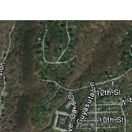
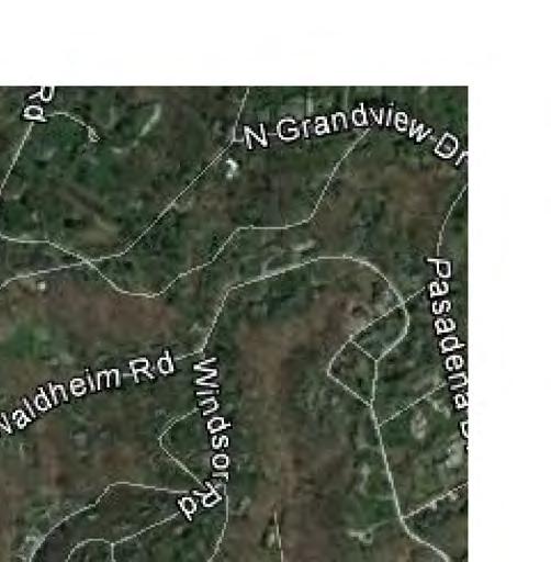
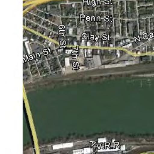

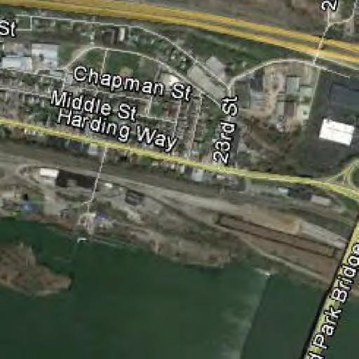
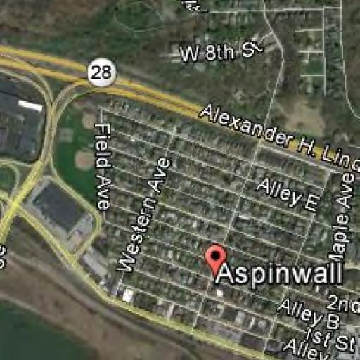
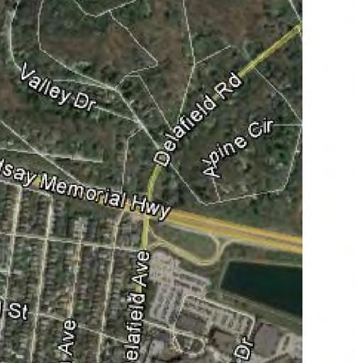

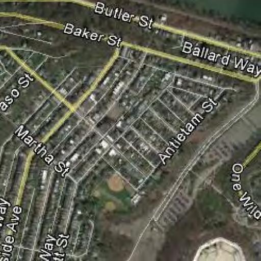
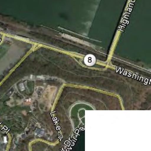
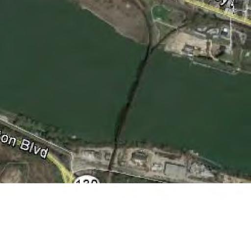
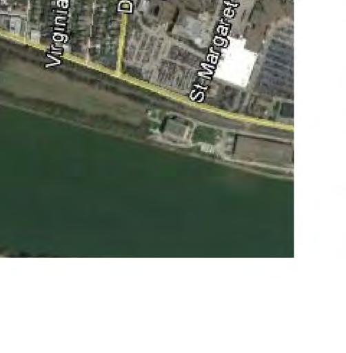
56 PLOTTED: 11/17/2016 8th St Ali St 18th St 19th St 21st St SITE Center Ave Ave Briliant Ave FILE NAME:P:\MOSIT00\ Acre Site\Figures\Traffic Im pact Sum m ary \Volum e Figures.dgn N SCALE: N.T.S. Tran s A SS O C IA T ES Small Firm Client Experience, Big Firm Capabilities 4955 Steubenville Pike, Twin Towers Suite 400 Pittsburgh, Pennsylvania 15205, PROJECT NO. PROJECT: TITLE: Freeport Rd MOSIT FIGURE Riverfront 47 Development Transportation Impact Study Site Location 1 D.B. CZ/MY C.B. MDS REV.


57 PLOTTED: 11/17/2016 FILE NAME:P:\MOSIT00\ Acre Site\Figures\Traffic Im pact Sum m ary \Recom m endation Figures.dgn N SCALE: N.T.S. Tran s A SS O C IA T ES Small Firm Client Experience, Big Firm Capabilities 4955 Steubenville Pike, Twin Towers Suite 400 Pittsburgh, Pennsylvania 15205, PROJECT NO. PROJECT: TITLE: MOSIT Riverfront 47 Development Transportation Impact Study Site Plan FIGURE 2 D.B. KBZ C.B. CAJ REV. CTZ
58 PLOTTED: 11/17/2016 Sharpsburg 8th St 18th St 21st St Ali St 19th St O'Hara/Aspinwall SB Ramps NB Ramps W estern Ave Center Ave Ave Briliant Ave 2nd Street Delafield Ave FILE NAME:P:\MOSIT00\ Acre Site\Figures\Novem ber 2016 Figures\ Figures.dgn Legend - Unsignalized Intersection - Signalized Intersection Highland Park Bridge N SCALE: N.T.S. Tran s A SS O C IA T ES Small Firm Client Experience, Big Firm Capabilities 4955 Steubenville Pike, Twin Towers Suite 400 Pittsburgh, Pennsylvania 15205, PROJECT NO. PROJECT: TITLE: MOSIT Riverfront 47 Development Transportation Impact Study Study Intersections FIGURE 3 D.B. MJY C.B. MDS REV.
59 PLOTTED: 11/17/2016 Sharpsburg 8th St 18th St 21st St [326] (510) 265 [4] (0) 2 35 (24) [14] 1 (0) [0] [1] (2) 2 17 (19) [12] [1] (2) (339) [378] 1 (1) [2] 35 (27) [16] 1 (1) [4] 14 (29) [22] [3] (4) 3 [218] (563) 223 [22] (16) 1 0 (14) [6] 401 (306) [221] 3 (7) [10] [10] (6) 4 [1] (0) 0 [5] (13) 3 32 (32) [18] 0 (1) [2] 160 (103) [122] [224] (436) 235 [0] (1) 1 15 (44) [22] 380 (497) [341] 2 (0) [0] [1] (4) 0 [0] (0) 0 [0] (1) 2 16 (25) [17] 39 (43) [35] 378 (538) [319] 464 (456) [451] 7 (5) [12] [14] (26) 17 [338] (483) 378 [341] (545) 394 [357] (508) 401 [10] (5) 1 [5] (7) 7 [9] (12) 5 11 (15) [12] 9 (17) [33] 472 (506) [480] FILE NAME:P:\MOSIT00\ Acre Site\Figures\Novem ber 2016 Figures\ Figures.dgn Ali St 19th St O'Hara/Aspinwall 128 (85) [75] 115 (228) [142] SB Ramps [292] (486) 251 [292] (486) 251 [113] (134) 205 Legend A.M. Peak Hour Traffic Volumes (123) - P.M. Peak Hour Traffic Volumes [123] - Saturday Peak Hour Traffic Volumes 391 (413) [415] 346 (387) [339] NB Ramps Highland Park Bridge 99 (121) [105] 1 (1) [0] [80] (181) 71 [354] (525) (143) [199] 639 (668) [684] [411] (379) (52) [32] 9 (9) [15] [31] (97) 8 [746] (792) 541 W estern Ave 10 (12) [12] 640 (741) [817] N 139 (59) [61] 23 (38) [36] [71] (122) 40 [690] (669) 508 SCALE: N.T.S. Center Ave 14 (38) [34] 523 (685) [764] 40 (58) [42] 1 (0) [2] [27] (37) 25 [594] (717) 456 [19] (20) 7 4 (15) [19] Sunoco Dwy Ave 12 (21) [30] 2 (2) [4] Tran s A SS O C IA T ES 512 (657) [685] Small Firm Client Experience, Big Firm Capabilities 4955 Steubenville Pike, Twin Towers Suite 400 Pittsburgh, Pennsylvania 15205, [4] (0) 4 [0] (0) 0 [2] (1) 0 [38] (50) 30 [594] (623) 412 [8] (3) 11 River Ave PROJECT NO. PROJECT: TITLE: 56 (51) [39] 1 (0) [0] [4] (12) 4 19 (30) [24] [0] (0) 0 [4] (11) 2 Briliant Ave 8 (5) [2] 2nd Street 25 (26) [31] 443 (823) [670] [37] (42) 41 [27] (63) 69 [576] (580) 368 MOSIT (25) [21] [27] (28) 8 92 (109) [59] 149 (162) [180] 55 (109) [113] Riverfront 47 Development Transportation Impact Study Delafield Ave [8] (8) Existing Conditions Peak Hour Traffic Volumes [136] (138) (101) [100] 382 (737) [679] D.B. C.B. REV. FIGURE 4 MJY MDS
60 PLOTTED: 11/17/2016 Sharpsburg 8th St 18th St 21st St 17% (17%) 17% 2% (2%) (17%) 19% 8% (8%) (19%) 27% (27%) 27% (27%) 27% (27%) Ali St 19th St O'Hara/Aspinwall SB Ramps NB Ramps W estern Ave Center Ave Ave Briliant Ave 2nd Street 9% Delafield Ave (9%) FILE NAME:P:\MOSIT00\ Acre Site\Figures\Novem ber 2016 Figures\ Figures.dgn 27% 27% Legend 12% - Arrival Distribution (12%) - Departure Distribution 8% (15%) (27%) [81] (183) 72 Highland Park Bridge 35% (8%) (42%) 15% 50% (50%) N 50% SCALE: N.T.S. (50%) 3% 50% Tran s A SS O C IA T ES Small Firm Client Experience, Big Firm Capabilities 4955 Steubenville Pike, Twin Towers Suite 400 Pittsburgh, Pennsylvania 15205, (50%) 47% (3%) (47%) (4%) (43%) PROJECT NO. PROJECT: TITLE: 4% 9% 43% 34% (9%) (34%) MOSIT FIGURE Riverfront 47 Development Transportation Impact Study Phase 1 Primary Trip Distribution ( Access) 5A D.B. MJY C.B. MDS REV.
61 PLOTTED: 11/17/2016 Sharpsburg 8th St 18th St 21st St 17% (17%) 17% 2% (2%) (17%) 19% 8% (8%) (19%) 27% (27%) 27% (27%) 27% (27%) Ali St 19th St O'Hara/Aspinwall SB Ramps NB Ramps W estern Ave Center Ave Ave Briliant Ave 2nd Street 9% Delafield Ave (9%) FILE NAME:P:\MOSIT00\ Acre Site\Figures\Novem ber 2016 Figures\ Figures.dgn 27% 27% Legend 12% - Arrival Distribution (12%) - Departure Distribution 8% (15%) (27%) [81] (183) 72 Highland Park Bridge 35% (8%) (42%) 15% 50% (50%) N 50% SCALE: N.T.S. (50%) 50% 3% Sunoco Dwy (3%) (50%) Tran s A SS O C IA T ES Small Firm Client Experience, Big Firm Capabilities 4955 Steubenville Pike, Twin Towers Suite 400 Pittsburgh, Pennsylvania 15205, PROJECT NO. PROJECT: TITLE: 53% 4% 9% ARP Access 43% 34% (53%) (4%) (43%) (9%) (34%) MOSIT FIGURE Riverfront 47 Development Transportation Impact Study Phase 1 Primary Trip Distribution ( Access) 5B D.B. MJY C.B. MDS REV.
62 PLOTTED: 11/17/2016 Sharpsburg 8th St 18th St 21st St (17%) 2% (2%) (17%) 17% 27% 17% 19% 8% (8%) (19%) (27%) 10% 17% (17%) (45%) (10%) 45% (45%) + 10% 45% + (10%) Ali St 19th St O'Hara/Aspinwall SB Ramps NB Ramps W estern Ave Center Ave Ave Briliant Ave 2nd Street 9% Delafield Ave (9%) FILE NAME:P:\MOSIT00\ Acre Site\Figures\Novem ber 2016 Figures\ Figures.dgn (36%) + 10% (36%) + 10% (9%) Legend 12% (12%) - Arrival Distribution - Departure Distribution 5% 3% (6%) 40% + (10%) Highland Park Bridge 9% 1 (1) [0] (5%) (31%) + 13% (3%) 31% + (16%) 6% (31%) + 19% 31% + (19%) (31%) + 19% N SCALE: N.T.S. 31% + (19%) 1% (2%) (29%) 19% Site Access Tran s A SS O C IA T ES Small Firm Client Experience, Big Firm Capabilities 4955 Steubenville Pike, Twin Towers Suite 400 Pittsburgh, Pennsylvania 15205, (19%) 29% 18% (1%) (18%) (4%) (43%) PROJECT NO. PROJECT: TITLE: 4% 9% 43% (9%) (34%) MOSIT FIGURE Riverfront 47 Development Transportation Impact Study 34% Full Development Primary Trip Distribution ( Avenue Access) 6A D.B. MJY C.B. MDS REV.
63 PLOTTED: 11/17/2016 Sharpsburg 8th St 18th St 21st St (17%) 2% (2%) (17%) 17% 27% 17% 19% 8% (8%) (19%) (27%) 10% 17% (17%) (45%) (10%) 45% (45%) + 10% 45% + (10%) Ali St 19th St O'Hara/Aspinwall SB Ramps NB Ramps W estern Ave Center Ave Ave Briliant Ave 2nd Street 9% Delafield Ave (9%) FILE NAME:P:\MOSIT00\ Acre Site\Figures\Novem ber 2016 Figures\ Figures.dgn (36%) + 10% (36%) + 10% (9%) Legend 12% (12%) - Arrival Distribution - Departure Distribution 5% 3% (6%) 40% + (10%) Highland Park Bridge 9% 1 (1) [0] (5%) (31%) + 13% (3%) 31% + (16%) 6% (31%) + 19% 31% + (19%) (31%) + 19% N SCALE: N.T.S. 31% + (19%) 2% (2%) (29%) 19% 1% Sunoco Dwy (1%) 29% + (19%) Tran s A SS O C IA T ES Small Firm Client Experience, Big Firm Capabilities 4955 Steubenville Pike, Twin Towers Suite 400 Pittsburgh, Pennsylvania 15205, PROJECT NO. PROJECT: TITLE: 2% 2% (2%) (27%) 20% ARP Access 27% 16% (20%) (2%) (16%) 9% (9%) (34%) MOSIT FIGURE Riverfront 47 Development Transportation Impact Study 34% Full Development Primary Trip Distribution ( Avenue Access) 6B D.B. MJY C.B. MDS REV.
64 PLOTTED: 11/17/2016 Sharpsburg 8th St 18th St 21st St Ali St 19th St O'Hara/Aspinwall SB Ramps NB Ramps W estern Ave Center Ave Ave Briliant Ave 2nd Street Delafield Ave FILE NAME:P:\MOSIT00\ Acre Site\Figures\Novem ber 2016 Figures\ Figures.dgn Legend 12% (12%) [12%] 12% ( 12%) - A.M. Arrival Distribution - P.M. Arrival Distribution - Saturday Arrival Distribution - A.M. Departure Distribution - P.M. Departure Distribution [ 12%] - Saturday Departure Distribution Highland Park Bridge N SCALE: N.T.S. [-47%] (-47%) -47% [47%] (47%) 47% Sunoco Dwy Tran s A SS O C IA T ES Small Firm Client Experience, Big Firm Capabilities 4955 Steubenville Pike, Twin Towers Suite 400 Pittsburgh, Pennsylvania 15205, % 43%) 53%] ( [ -53% (-53%) [-53%] 53% (53%) [53%] 47% 47%) 47%] ( [ PROJECT NO. PROJECT: TITLE: MOSIT FIGURE Riverfront 47 Development Transportation Impact Study Phase 1 Pass-By Distribution ( Avenue Access) 7A D.B. MJY C.B. MDS REV.
65 PLOTTED: 11/17/2016 Sharpsburg 8th St 18th St 21st St O'Hara/Aspinwall W estern Ave Ali St 19th St SB Ramps NB Ramps Center Ave Ave Briliant Ave 2nd Street Delafield Ave FILE NAME:P:\MOSIT00\ Acre Site\Figures\Novem ber 2016 Figures\ Figures.dgn Legend 12% (12%) [12%] 12% ( 12%) - A.M. Arrival Distribution - P.M. Arrival Distribution - Saturday Arrival Distribution - A.M. Departure Distribution - P.M. Departure Distribution [ 12%] - Saturday Departure Distribution Highland Park Bridge N SCALE: N.T.S. Sunoco Dwy Tran s A SS O C IA T ES Small Firm Client Experience, Big Firm Capabilities 4955 Steubenville Pike, Twin Towers Suite 400 Pittsburgh, Pennsylvania 15205, [-47%] (-43%) -48% [47%] (43%) 48% PROJECT NO. PROJECT: TITLE: ARP Access 52% 47%) 53%] ( [ -52% (-57%) [-53%] 52% (57%) [53%] 48% 43%) 47%] ( [ MOSIT Riverfront 47 Development Transportation Impact Study Phase 1 Pass-By Distribution ( Avenue Access) D.B. C.B. REV. FIGURE 7B MJY MDS
66 PLOTTED: 11/17/2016 Sharpsburg 8th St 18th St 21st St [-49%] (-50%) -52% [49%] (50%) 52% 48% 50%) 51%] ( -48% (-50%) [-51%] 48% (50%) [51%] 52% 50%) 49%] ( Ali St 19th St [ [ O'Hara/Aspinwall SB Ramps NB Ramps W estern Ave Center Ave Ave Briliant Ave 2nd Street Delafield Ave FILE NAME:P:\MOSIT00\ Acre Site\Figures\Novem ber 2016 Figures\ Figures.dgn Legend 12% (12%) [12%] 12% ( 12%) - A.M. Arrival Distribution - P.M. Arrival Distribution - Saturday Arrival Distribution - A.M. Departure Distribution - P.M. Departure Distribution [ 12%] - Saturday Departure Distribution Highland Park Bridge N SCALE: N.T.S. [-47%] (-47%) -47% [47%] (47%) 47% Site Access Tran s A SS O C IA T ES Small Firm Client Experience, Big Firm Capabilities 4955 Steubenville Pike, Twin Towers Suite 400 Pittsburgh, Pennsylvania 15205, % 53%) 53%] ( [ -53% (-53%) [-53%] 53% (53%) [53%] 47% 47%) 47%] ( [ PROJECT NO. PROJECT: TITLE: MOSIT FIGURE Riverfront 47 Development Transportation Impact Study Full Development Pass-By Distribution ( Avenue Access) 8A D.B. MJY C.B. MDS REV.
67 PLOTTED: 11/17/2016 Sharpsburg 8th St 18th St 21st St [-49%] (-50%) -52% [49%] (50%) 52% 48% 50%) 51%]( -48% (-50%) [-51%] 48% (50%) [51%] 52% 50%) 49%] ( Ali St 19th St O'Hara/Aspinwall [ [ SB Ramps NB Ramps W estern Ave Center Ave Ave Briliant Ave 2nd Street Delafield Ave FILE NAME:P:\MOSIT00\ Acre Site\Figures\Novem ber 2016 Figures\ Figures.dgn Legend 12% (12%) [12%] 12% ( 12%) - A.M. Arrival Distribution - P.M. Arrival Distribution - Saturday Arrival Distribution - A.M. Departure Distribution - P.M. Departure Distribution [ 12%] - Saturday Departure Distribution Highland Park Bridge N SCALE: N.T.S. Sunoco Dwy Tran s A SS O C IA T ES Small Firm Client Experience, Big Firm Capabilities 4955 Steubenville Pike, Twin Towers Suite 400 Pittsburgh, Pennsylvania 15205, [-47%] (-43%) -48% [47%] (43%) 48% PROJECT NO. PROJECT: TITLE: ARP Access 52% 47%) 53%] ( [ -52% (-57%) [-53%] 52% (57%) [53%] 48% 43%) 47%] ( [ MOSIT Riverfront 47 Development Transportation Impact Study Full Development Pass-By Distribution ( Avenue Access) D.B. C.B. REV. FIGURE 8B MJY MDS
68 PLOTTED: 11/17/2016 Sharpsburg 8th St Ali St 18th St 21st St [23] (26) (20) [21] 2 (3) [3] 3 (2) [2] 27 (20) [21] [23] (26) 21 [26] (29) (12) [11] 13 (9) [10] 30 (22) [23] [37] (41) (31) [33] 43 (31) [33] [37] (41) 33 [37] (41) (31) [33] 19th St O'Hara/Aspinwall SB Ramps NB Ramps W estern Ave Center Ave Ave Briliant Ave 2nd Street [4] (4) 5 4 (4) [4] 4 (5) [4] Delafield Ave [4] (4) 5 FILE NAME:P:\MOSIT00\ Acre Site\Figures\Novem ber 2016 Figures\ Figures.dgn [37] (41) 33 [37] (41) 33 Legend A.M. Peak Hour Traffic Volumes (123) - P.M. Peak Hour Traffic Volumes [123] - Saturday Peak Hour Traffic Volumes 10 (12) [10] 24 (17) [19] 43 (31) [33] Highland Park Bridge [47] (53) (9) [10] 67 (48) [52] [20] (22) 19 [67] (75) (57) [62] [67] (75) 62 N SCALE: N.T.S. 79 (57) [62] 7 (10) [8] [67] (75) 62 Site Access 55 (65) [59] Tran s A SS O C IA T ES Small Firm Client Experience, Big Firm Capabilities 4955 Steubenville Pike, Twin Towers Suite 400 Pittsburgh, Pennsylvania 15205, [62] (57) 79 [7] (7) 9 [56] (53) 70 [9] (9) 11 [47] (44) 59 PROJECT NO. PROJECT: TITLE: 9 (9) [9] 4 (5) [4] 46 (56) [50] [4] (4) 5 [43] (40) (51) [46] MOSIT FIGURE Riverfront 47 Development Transportation Impact Study Phase 1 Primary Peak Hour Traffic Volumes ( Avenue Access) 9A D.B. MJY C.B. MDS REV.
69 PLOTTED: 11/17/2016 Sharpsburg 8th St 18th St 21st St [23] (26) (20) [21] [23] (26) 21 2 (3) [3] 3 (2) [2] 27 (20) [21] [26] (29) (12) [11] 13 (9) [10] 30 (22) [23] [37] (41) (31) [33] [37] (41) (31) [33] [37] (41) (31) [33] Ali St 19th St O'Hara/Aspinwall SB Ramps NB Ramps W estern Ave Center Ave Ave Briliant Ave 2nd Street [4] (4) 5 4 (4) [4] 4 (5) [4] Delafield Ave [4] (4) 5 FILE NAME:P:\MOSIT00\ Acre Site\Figures\Novem ber 2016 Figures\ Figures.dgn [37] (41) 33 [37] (41) 33 Legend A.M. Peak Hour Traffic Volumes (123) - P.M. Peak Hour Traffic Volumes [123] - Saturday Peak Hour Traffic Volumes 10 (12) [10] 24 (17) [19] 43 (31) [33] Highland Park Bridge [47] (53) (9) [10] 67 (48) [52] [20] (22) 19 [67] (75) (57) [62] [67] (75) 62 N SCALE: N.T.S. 79 (57) [62] [67] (75) 62 4 (5) [4] Sunoco Dwy 5 (4) [4] 79 (57) [62] Tran s A SS O C IA T ES Small Firm Client Experience, Big Firm Capabilities 4955 Steubenville Pike, Twin Towers Suite 400 Pittsburgh, Pennsylvania 15205, [71] (80) 66 ARP Access PROJECT NO. PROJECT: TITLE: 12 (14) [13] 4 (5) [4] 46 (56) [50] [4] (4) 5 [66] (61) 84 [12] (12) 15 [47] (44) 59 [43] (40) (51) [46] MOSIT FIGURE Riverfront 47 Development Transportation Impact Study Phase 1 Primary Peak Hour Traffic Volumes ( Avenue Access) 9B D.B. MJY C.B. MDS REV.
70 PLOTTED: 11/17/2016 Sharpsburg 8th St 18th St 21st St -1 (-1) [0] -1 (-1) [0] -1 (-1) [0] -1 (-1) [0] -1 (-1) [0] -1 (-1) [0] Ali St 19th St O'Hara/Aspinwall SB Ramps NB Ramps W estern Ave Center Ave Ave Briliant Ave 2nd Street Delafield Ave FILE NAME:P:\MOSIT00\ Acre Site\Figures\Novem ber 2016 Figures\ Figures.dgn Legend 123 (123) - A.M. Peak Hour Traffic Volumes - P.M. Peak Hour Traffic Volumes [123] - Saturday Peak Hour Traffic Volumes -1 (-1) [0] -1 (-1) [0] -1 (-1) [0] -1 (-1) [0] Highland Park Bridge N SCALE: N.T.S. [-3] (-3) -2 [3] (3) 2 Site Access -3 (-3) [-3] 3 (3) [3] Tran s A SS O C IA T ES Small Firm Client Experience, Big Firm Capabilities 4955 Steubenville Pike, Twin Towers Suite 400 Pittsburgh, Pennsylvania 15205, [3] (2) 2 [2] (2) 2 [-1] (-1) 0 [-1] (-1) 0 PROJECT NO. PROJECT: TITLE: MOSIT FIGURE Riverfront 47 Development Transportation Impact Study Phase 1 Pass-By Peak Hour Traffic Volumes ( Avenue Access) 10A D.B. MJY C.B. MDS REV.
71 PLOTTED: 11/17/2016 Sharpsburg 8th St 18th St 21st St -1 (-1) [0] -1 (-1) [0] -1 (-1) [0] -1 (-1) [0] -1 (-1) [0] -1 (-1) [0] Ali St 19th St O'Hara/Aspinwall SB Ramps NB Ramps W estern Ave Center Ave Ave Briliant Ave 2nd Street Delafield Ave FILE NAME:P:\MOSIT00\ Acre Site\Figures\Novem ber 2016 Figures\ Figures.dgn Legend 123 (123) - A.M. Peak Hour Traffic Volumes - P.M. Peak Hour Traffic Volumes [123] - Saturday Peak Hour Traffic Volumes -1 (-1) [0] -1 (-1) [0] -1 (-1) [0] -1 (-1) [0] Highland Park Bridge N SCALE: N.T.S. Sunoco Dwy -1 (-1) [0] Tran s A SS O C IA T ES Small Firm Client Experience, Big Firm Capabilities 4955 Steubenville Pike, Twin Towers Suite 400 Pittsburgh, Pennsylvania 15205, [-3] (-3) -2 [3] (3) 2 ARP Access PROJECT NO. PROJECT: TITLE: -3 (-3) [-3] 3 (3) [3] [3] (2) 2 [2] (2) 2 [-1] (-1) 0 MOSIT FIGURE Riverfront 47 Development Transportation Impact Study Phase 1 Pass-By Peak Hour Traffic Volumes ( Avenue Access) 10B D.B. MJY C.B. MDS REV.
72 PLOTTED: 11/17/2016 Sharpsburg 8th St Ali St 18th St 21st St [23] (26) (19) [21] [23] (26) 21 2 (3) [3] 3 (2) [2] 26 (19) [21] [26] (29) (12) [11] 13 (9) [10] 29 (21) [23] 42 (30) [33] 42 (30) [33] [37] (41) 33 [37] (41) 33 [37] (41) (30) [33] 19th St O'Hara/Aspinwall SB Ramps NB Ramps W estern Ave Center Ave Ave Briliant Ave 2nd Street [4] (4) 5 4 (4) [4] 4 (5) [4] Delafield Ave [4] (4) 5 FILE NAME:P:\MOSIT00\ Acre Site\Figures\Novem ber 2016 Figures\ Figures.dgn [37] (41) 33 [37] (41) 33 Legend A.M. Peak Hour Traffic Volumes (123) - P.M. Peak Hour Traffic Volumes [123] - Saturday Peak Hour Traffic Volumes 10 (12) [10] 24 (17) [19] 42 (30) [33] Highland Park Bridge [47] (53) (9) [10] 66 (47) [52] [20] (22) 19 [67] (75) (56) [62] 78 (56) [62] [67] (75) 62 N SCALE: N.T.S. 7 (10) [8] [-3] (-3) -2 [70] (78) 64 Site Access -3 (-3) [-3] 58 (68) [62] Tran s A SS O C IA T ES Small Firm Client Experience, Big Firm Capabilities 4955 Steubenville Pike, Twin Towers Suite 400 Pittsburgh, Pennsylvania 15205, [65] (59) 81 [7] (7) 9 [58] (55) 72 [9] (9) 11 [46] (43) 59 PROJECT NO. PROJECT: TITLE: 9 (9) [9] 4 (5) [4] 46 (56) [50] [4] (4) 5 [44] (39) (51) [46] MOSIT FIGURE Riverfront 47 Development Transportation Impact Study Phase 1 Total Peak Hour Traffic Volumes ( Avenue Access) 11A D.B. MJY C.B. MDS REV.
73 PLOTTED: 11/17/2016 Sharpsburg 8th St Ali St 18th St 21st St [23] (26) (19) [21] [23] (26) 21 2 (3) [3] 3 (2) [2] 26 (19) [21] 0 (0) [0] [26] (29) (12) [11] 13 (9) [10] 29 (21) [23] [37] (41) (30) [33] 42 (30) [33] [37] (41) 33 [37] (41) (30) [33] 19th St O'Hara/Aspinwall SB Ramps NB Ramps W estern Ave Center Ave Ave Briliant Ave 2nd Street [4] (4) 5 4 (4) [4] 4 (5) [4] Delafield Ave [4] (4) 5 FILE NAME:P:\MOSIT00\ Acre Site\Figures\Novem ber 2016 Figures\ Figures.dgn [37] (41) 33 [37] (41) 33 Legend A.M. Peak Hour Traffic Volumes (123) - P.M. Peak Hour Traffic Volumes [123] - Saturday Peak Hour Traffic Volumes 10 (12) [10] 24 (17) [19] 42 (30) [33] Highland Park Bridge [47] (53) (9) [10] 66 (47) [52] [20] (22) 19 [67] (75) (56) [62] [67] (75) 62 [67] (75) 62 N SCALE: N.T.S. 78 (56) [62] 4 (5) [4] Sunoco Dwy 5 (4) [4] 78 (56) [62] Tran s A SS O C IA T ES Small Firm Client Experience, Big Firm Capabilities 4955 Steubenville Pike, Twin Towers Suite 400 Pittsburgh, Pennsylvania 15205, (14) [13] [-3] (-3) -2 [74] (83) 68 ARP Access PROJECT NO. PROJECT: TITLE: -3 (-3) [-3] 49 (59) [53] [69] (63) 86 [12] (12) 15 [49] (46) 61 4 (5) [4] [4] (4) 5 [42] (39) (51) [46] MOSIT FIGURE Riverfront 47 Development Transportation Impact Study Phase 1 Total Peak Hour Traffic Volumes ( Avenue Access) 11B D.B. MJY C.B. MDS REV.
74 PLOTTED: 11/17/2016 Sharpsburg 8th St 18th St 21st St [50] (59) (76) [47] 8 (7) [7] 7 (8) [5] 62 (76) [47] [50] (59) 72 [58] (66) (28) [24] 29 (35) [22] 69 (84) [52] [81] (94) (119) [74] 43 (31) [33] 219 (140) [115] [37] (41) 33 [148] (279) 185 [44] (53) 81 [41] (88) 55 [111] (238) (171) [148] Ali St 19th St O'Hara/Aspinwall SB Ramps NB Ramps W estern Ave Center Ave Ave Briliant Ave 2nd Street 13 (9) [9] 13 (11) [9] [9] (14) 11 Delafield Ave [9] (14) 11 FILE NAME:P:\MOSIT00\ Acre Site\Figures\Novem ber 2016 Figures\ Figures.dgn 24 (16) [12] 10 (12) [10] [125] (230) 153 [125] (230) 153 [23] (49) 32 Legend A.M. Peak Hour Traffic Volumes (123) - P.M. Peak Hour Traffic Volumes [123] - Saturday Peak Hour Traffic Volumes 24 (17) [19] 238 (155) [136] Highland Park Bridge 45 (30) [24] [12] (26) 16 [123] (216) (9) [10] 166 (65) [65] [20] (22) 19 9 (5) [5] [5] (10) 6 [138] (228) (146) [136] [138] (228) 160 N SCALE: N.T.S. 220 (146) [136] 9 (6) [5] 7 (10) [8] [4] (9) 6 [67] (144) 92 [67] (75) 62 Site Access Tran s A SS O C IA T ES Small Firm Client Experience, Big Firm Capabilities 4955 Steubenville Pike, Twin Towers Suite 400 Pittsburgh, Pennsylvania 15205, [62] (57) (83) [69] 55 (65) [59] [7] (7) 9 [56] (53) 70 PROJECT NO. PROJECT: TITLE: 30 (21) [19] [19] (32) 26 [104] (165) (127) [109] MOSIT Riverfront 47 Development Transportation Impact Study Full Development Primary Peak Hour Traffic Volumes 13 (11) [9] [9] (14) 11 [95] (151) 125 ( Avenue Access) 144 (116) [100] D.B. C.B. REV. FIGURE 12A MJY MDS
75 PLOTTED: 11/17/2016 Sharpsburg 8th St 18th St 21st St [50] (59) (76) [47] 8 (7) [7] 7 (8) [5] 62 (76) [47] [50] (59) 72 [58] (66) (28) [24] 29 (35) [22] 69 (84) [52] [81] (94) (119) [74] 43 (31) [33] 219 (140) [115] [37] (41) 33 [148] (279) 185 [44] (53) 81 [41] (88) 55 [111] (238) (171) [148] Ali St 19th St O'Hara/Aspinwall SB Ramps NB Ramps W estern Ave Center Ave Ave Briliant Ave 2nd Street 13 (9) [9] 13 (11) [9] [9] (14) 11 Delafield Ave [9] (14) 11 FILE NAME:P:\MOSIT00\ Acre Site\Figures\Novem ber 2016 Figures\ Figures.dgn 24 (16) [12] 10 (12) [10] [125] (230) 153 [125] (230) 153 [23] (49) 32 Legend A.M. Peak Hour Traffic Volumes (123) - P.M. Peak Hour Traffic Volumes [123] - Saturday Peak Hour Traffic Volumes 24 (17) [19] 238 (155) [136] Highland Park Bridge 45 (30) [24] [12] (26) 16 [123] (216) (9) [10] 166 (65) [65] [20] (22) 19 9 (5) [5] [5] (10) 6 [138] (228) (146) [136] [138] (228) 160 N SCALE: N.T.S. 220 (146) [136] 9 (6) [5] [4] (9) 6 [134] (219) (5) [4] Sunoco Dwy 5 (4) [4] Tran s A SS O C IA T ES 211 (140) [131] Small Firm Client Experience, Big Firm Capabilities 4955 Steubenville Pike, Twin Towers Suite 400 Pittsburgh, Pennsylvania 15205, PROJECT NO. PROJECT: TITLE: 21 (12) [10] 12 (14) [13] [10] (23) 15 [57] (121) 77 [71] (80) 66 ARP Access [66] (61) (71) [59] 46 (56) [50] [12] (12) 15 [47] (44) 59 MOSIT (11) [9] [9] (14) 11 [95] (151) 125 Riverfront 47 Development Transportation Impact Study Full Development Primary Peak Hour Traffic Volumes ( Avenue Access) 144 (116) [100] D.B. C.B. REV. FIGURE 12B MJY MDS
76 PLOTTED: 11/17/2016 Sharpsburg 8th St 18th St 21st St -1 (-2) [0] -1 (-2) [0] -1 (-2) [0] -3 (-4) [-3] -1 (-2) [0] 2 (3) [3] -1 (-1) [0] [-3] (-3) -3 [3] (3) 3 [3] (2) 2 [2] (2) 2 [-1] (-1) -1 Ali St 19th St O'Hara/Aspinwall SB Ramps NB Ramps W estern Ave Center Ave Ave Briliant Ave 2nd Street Delafield Ave FILE NAME:P:\MOSIT00\ Acre Site\Figures\Novem ber 2016 Figures\ Figures.dgn Legend 123 (123) [-1] (-1) -1 [-1] (-1) -1 - A.M. Peak Hour Traffic Volumes - P.M. Peak Hour Traffic Volumes [123] - Saturday Peak Hour Traffic Volumes Highland Park Bridge -1 (-1) [0] -1 (-1) [0] -1 (-1) [0] -1 (-1) [0] [-1] (-1) -1 [-1] (-1) -1 [-1] (-1) -1 N SCALE: N.T.S. [-4] (-4) -3 [3] (3) 2 Site Access -3 (-3) [-3] 3 (3) [3] Tran s A SS O C IA T ES Small Firm Client Experience, Big Firm Capabilities 4955 Steubenville Pike, Twin Towers Suite 400 Pittsburgh, Pennsylvania 15205, [3] (2) 2 [2] (2) 2 [-2] (-2) -1 [-2] (-2) -1 PROJECT NO. PROJECT: TITLE: MOSIT FIGURE Riverfront 47 Development Transportation Impact Study Full Development Pass-By Peak Hour Traffic Volumes ( Avenue Access) 13A D.B. MJY C.B. MDS REV.
77 PLOTTED: 11/17/2016 Sharpsburg 8th St 18th St 21st St -1 (-2) [0] -1 (-2) [0] -1 (-2) [0] -3 (-4) [-3] -1 (-2) [0] 2 (3) [3] -1 (-1) [0] [-3] (-3) -3 [3] (3) 3 [3] (2) 2 [2] (2) 2 [-1] (-1) -1 Ali St 19th St O'Hara/Aspinwall SB Ramps NB Ramps W estern Ave Center Ave Ave Briliant Ave 2nd Street Delafield Ave FILE NAME:P:\MOSIT00\ Acre Site\Figures\Novem ber 2016 Figures\ Figures.dgn Legend 123 (123) [123] [-1] (-1) -1 [-1] (-1) -1 - A.M. Peak Hour Traffic Volumes - P.M. Peak Hour Traffic Volumes - Saturday Peak Hour Traffic Volumes Highland Park Bridge -1 (-1) [0] -1 (-1) [0] -1 (-1) [0] -1 (-1) [0] [-1] (-1) -1 [-1] (-1) -1 [-1] (-1) -1 [-1] (-1) -1 N SCALE: N.T.S. Sunoco Dwy -1 (-1) [0] Tran s A SS O C IA T ES Small Firm Client Experience, Big Firm Capabilities 4955 Steubenville Pike, Twin Towers Suite 400 Pittsburgh, Pennsylvania 15205, [-4] (-4) -3 [3] (3) 2 PROJECT NO. PROJECT: TITLE: ARP Access -3 (-3) [-3] 3 (3) [3] [3] (2) 2 [2] (2) 2 [-2] (-2) -1 MOSIT FIGURE Riverfront 47 Development Transportation Impact Study Full Development Pass-By Peak Hour Traffic Volumes ( Avenue Access) 13B D.B. MJY C.B. MDS REV.
78 PLOTTED: 11/17/2016 Sharpsburg 8th St 18th St 21st St [50] (59) (74) [47] [50] (59) 72 8 (7) [7] 7 (8) [5] 61 (74) [47] [57] (66) (28) [24] 29 (35) [22] 68 (82) [52] [81] (94) (117) [74] [34] (38) 30 [47] (56) 84 [44] (90) 57 [113] (240) (27) [30] 221 (143) [118] [147] (278) (170) [148] Ali St 19th St O'Hara/Aspinwall SB Ramps NB Ramps W estern Ave Center Ave Ave Briliant Ave 2nd Street 13 (9) [9] 13 (11) [9] [9] (14) 11 Delafield Ave [9] (14) 11 FILE NAME:P:\MOSIT00\ Acre Site\Figures\Novem ber 2016 Figures\ Figures.dgn 24 (16) [12] 10 (12) [10] [124] (229) 152 [124] (229) 152 [23] (49) 32 Legend A.M. Peak Hour Traffic Volumes (123) - P.M. Peak Hour Traffic Volumes [123] - Saturday Peak Hour Traffic Volumes 24 (17) [19] 237 (154) [136] [12] (26) 16 [122] (215) 146 Highland Park Bridge 45 (30) [24] 12 (9) [10] 216 (141) [131] [20] (22) 19 9 (5) [5] [5] (10) 6 [137] (227) (145) [136] [137] (227) 159 N SCALE: N.T.S. 219 (145) [136] 9 (6) [5] 7 (10) [8] [4] (9) 6 [63] (140) 89 [70] (78) 64 Site Access 129 (80) [66] 58 (68) [62] Tran s A SS O C IA T ES Small Firm Client Experience, Big Firm Capabilities 4955 Steubenville Pike, Twin Towers Suite 400 Pittsburgh, Pennsylvania 15205, [65] (59) 81 [7] (7) 9 [58] (55) 72 [19] (32) 26 [102] (163) 135 PROJECT NO. PROJECT: TITLE: 30 (21) [19] 157 (127) [109] [95] (149) 124 MOSIT (11) [9] [9] (14) 11 Riverfront 47 Development Transportation Impact Study Full Development Total Site Peak Hour Traffic Volumes ( Avenue Access) 144 (116) [100] D.B. C.B. REV. FIGURE 14A MJY MDS
79 PLOTTED: 11/17/2016 Sharpsburg 8th St 18th St 21st St [50] (59) (74) [47] [50] (59) 72 8 (7) [7] 7 (8) [5] 61 (74) [47] [57] (66) (28) [24] 29 (35) [22] 68 (82) [52] [81] (94) (117) [74] [34] (38) 30 [47] (56) 84 [44] (90) 57 [113] (240) (27) [30] 221 (143) [118] [147] (278) (170) [148] Ali St 19th St O'Hara/Aspinwall SB Ramps NB Ramps W estern Ave Center Ave Ave Briliant Ave 2nd Street 13 (9) [9] 13 (11) [9] [9] (14) 11 Delafield Ave [9] (14) 11 FILE NAME:P:\MOSIT00\ Acre Site\Figures\Novem ber 2016 Figures\ Figures.dgn 24 (16) [12] 10 (12) [10] [124] (229) 152 [124] (229) 152 [23] (49) 32 Legend A.M. Peak Hour Traffic Volumes (123) - P.M. Peak Hour Traffic Volumes [123] - Saturday Peak Hour Traffic Volumes 24 (17) [19] 237 (154) [136] Highland Park Bridge 45 (30) [24] [12] (26) 16 [122] (215) (9) [10] 216 (141) [131] [20] (22) 19 9 (5) [5] [5] (10) 6 [137] (227) (145) [136] [137] (227) 159 N SCALE: N.T.S. 219 (145) [136] 9 (6) [5] [4] (9) 6 [133] (218) (5) [4] Sunoco Dwy 5 (4) [4] Tran s A SS O C IA T ES 210 (139) [131] Small Firm Client Experience, Big Firm Capabilities 4955 Steubenville Pike, Twin Towers Suite 400 Pittsburgh, Pennsylvania 15205, [10] (23) 15 [53] (117) 74 [74] (83) 68 PROJECT NO. PROJECT: TITLE: 21 (12) [10] 12 (14) [13] ARP Access [69] (63) (68) [56] 49 (59) [53] [12] (12) 15 [49] (46) 61 [93] (149) 124 MOSIT (11) [9] [9] (14) 11 Riverfront 47 Development Transportation Impact Study Full Development Total Site Peak Hour Traffic Volumes ( Avenue Access) 144 (116) [100] D.B. C.B. REV. FIGURE 14B MJY MDS
80 PLOTTED: 11/17/2016 Sharpsburg 8th St 18th St 21st St [340] (520) 282 [4] (0) 2 35 (24) [14] 1 (0) [0] [1] (2) 2 17 (19) [12] [1] (2) (349) [390] 1 (1) [2] 35 (27) [16] 1 (1) [4] 16 (30) [23] [3] (4) 3 [231] (574) 239 [22] (16) 1 1 (15) [7] 414 (315) [231] 3 (7) [10] [10] (6) 4 [1] (0) 0 [5] (13) 3 32 (32) [18] 0 (1) [2] 168 (106) [127] [14] (26) 17 [238] (447) 253 [0] (1) 1 19 (46) [25] 394 (509) [354] 2 (0) [0] [1] (4) 0 [0] (0) 0 [0] (1) 2 16 (25) [17] [358] (496) (43) [35] 483 (470) [468] [361] (559) 420 [10] (5) 1 [5] (7) 7 [9] (12) (553) [334] 7 (5) [12] 11 (15) [12] [377] (521) (17) [33] 491 (520) [497] FILE NAME:P:\MOSIT00\ Acre Site\Figures\Novem ber 2016 Figures\ Figures.dgn Ali St 19th St O'Hara/Aspinwall 129 (86) [76] 120 (232) [146] SB Ramps [311] (499) 276 [311] (499) 276 [114] (135) 207 Legend A.M. Peak Hour Traffic Volumes (123) - P.M. Peak Hour Traffic Volumes [123] - Saturday Peak Hour Traffic Volumes 403 (422) [425] 364 (400) [355] NB Ramps Highland Park Bridge 100 (122) [106] 1 (1) [0] [81] (183) 72 [377] (541) (147) [203] 668 (689) [709] [423] (388) (53) [32] 9 (9) [15] [31] (98) 8 [781] (815) 585 W estern Ave 10 (12) [12] 672 (765) [846] N 140 (60) [62] 23 (38) [36] [72] (123) 40 [724] (691) 551 SCALE: N.T.S. Center Ave 14 (38) [34] 553 (708) [792] 40 (59) [42] 1 (0) [2] [27] (37) 25 [627] (740) 499 [19] (20) 7 6 (16) [20] Sunoco Dwy Ave Tran s A SS O C IA T ES Small Firm Client Experience, Big Firm Capabilities 4955 Steubenville Pike, Twin Towers Suite 400 Pittsburgh, Pennsylvania 15205, [4] (0) 4 13 (22) [31] 542 (680) [712] 2 (2) [4] [0] (0) 0 [2] (1) 0 [38] (51) 30 [600] (630) 416 [36] (19) 51 River Ave PROJECT NO. PROJECT: TITLE: 57 (52) [39] 1 (0) [0] [25] (29) (30) [24] [0] (0) 0 [30] (37) 6 Briliant Ave 2nd Street 25 (26) [31] 448 (832) [677] 19 (21) [11] MOSIT (25) [21] [37] (42) 41 [27] (28) 8 95 (113) [62] [32] (69) 71 [603] (607) (167) [184] 56 (110) [114] Riverfront 47 Development Transportation Impact Study Delafield Ave [8] (8) 3 [142] (144) (102) [101] 395 (758) [693] Opening Year No Conditions Peak Hour Traffic Volumes D.B. C.B. REV. FIGURE 15 MJY MDS
81 PLOTTED: 11/17/2016 Sharpsburg 8th St 18th St 21st St Ali St 19th St O'Hara/Aspinwall SB Ramps NB Ramps W estern Ave Center Ave Ave Briliant Ave 2nd Street Delafield Ave FILE NAME:P:\MOSIT00\ Acre Site\Figures\Novem ber 2016 Figures\ Figures.dgn Legend A.M. Peak Hour Traffic Volumes (123) - P.M. Peak Hour Traffic Volumes [123] - Saturday Peak Hour Traffic Volumes Highland Park Bridge N SCALE: N.T.S. 3 (1) [1] [-32] (-19) -51 [32] (19) 51-2 (-1) [-1] Site Access Tran s A SS O C IA T ES Small Firm Client Experience, Big Firm Capabilities 4955 Steubenville Pike, Twin Towers Suite 400 Pittsburgh, Pennsylvania 15205, [25] (29) 30-1 (-1) [-1] -30 (-29) [-25] 19 (21) [11] [1] (1) 1 [30] (37) 6 [34] (38) 6 [-36] (-19) -51 River Ave PROJECT NO. PROJECT: TITLE: -1 (0) [0] [-25] (-29) -30 [0] (0) 0 [-30] (-37) (21) [11] -19 (-21) [-11] MOSIT Riverfront 47 Development Transportation Impact Study Access Peak Hour Traffic Volumes Rerouted River Avenue to Avenue D.B. C.B. REV. FIGURE 16 MJY MDS
82 PLOTTED: 11/17/2016 Sharpsburg 8th St 18th St 21st St Ali St 19th St O'Hara/Aspinwall SB Ramps NB Ramps W estern Ave Center Ave Ave Briliant Ave 2nd Street Delafield Ave FILE NAME:P:\MOSIT00\ Acre Site\Figures\Novem ber 2016 Figures\ Figures.dgn Legend A.M. Peak Hour Traffic Volumes (123) - P.M. Peak Hour Traffic Volumes [123] - Saturday Peak Hour Traffic Volumes Highland Park Bridge N SCALE: N.T.S. -1 (0) [-2] [19] (20) 7 [-19] (-20) -7 1 (0) [2] Sunoco Dwy 6 (2) [16] -2 (-2) [-4] Tran s A SS O C IA T ES Small Firm Client Experience, Big Firm Capabilities 4955 Steubenville Pike, Twin Towers Suite 400 Pittsburgh, Pennsylvania 15205, [-4] (0) -4 [0] (0) 0 [-1] (-1) 0 River Ave PROJECT NO. PROJECT: TITLE: MOSIT FIGURE Riverfront 47 Development Transportation Impact Study Elimination of Sunoco Peak Hour Traffic Volumes 17 D.B. MJY C.B. MDS REV.
83 PLOTTED: 11/17/2016 Sharpsburg 8th St 18th St 21st St O'Hara/Aspinwall W estern Ave Ali St Ave 19th St SB Ramps NB Ramps Center Ave Briliant Ave 2nd Street Delafield Ave FILE NAME:P:\MOSIT00\ Acre Site\Figures\Novem ber 2016 Figures\ Figures.dgn Highland Park Bridge N SCALE: N.T.S. Sunoco Dwy [36] (19) 51 [-36] (-19) -51 Tran s A SS O C IA T ES River Ave Small Firm Client Experience, Big Firm Capabilities 4955 Steubenville Pike, Twin Towers Suite 400 Pittsburgh, Pennsylvania 15205, [-25] (-29) (29) [25] -19 (-21) [-11] [-30] (-37) -6 [-30] -37) -6 [36] (19) 51 PROJECT NO. PROJECT: TITLE: ARP Access [25] (29) (-21) [-11] 19 (21) [11] [0] (0) 0 [30] (37) 6 MOSIT Riverfront 47 Development Transportation Impact Study Rerouted River Avenue to Avenue Access Peak Hour Traffic Volumes D.B. C.B. REV. FIGURE 18 MJY MDS
84 PLOTTED: 11/17/2016 Sharpsburg 8th St 18th St 21st St [363] (546) 303 [4] (0) 2 35 (24) [14] 1 (0) [0] [1] (2) 2 17 (19) [12] [1] (2) (368) [411] 1 (1) [2] 35 (27) [16] 1 (1) [4] 18 (33) [26] [3] (4) 3 [254] (600) 260 [22] (16) 1 4 (17) [9] 440 (334) [252] 3 (7) [10] [10] (6) 4 [1] (0) 0 [5] (13) 3 32 (32) [18] 0 (1) [2] 178 (118) [138] [14] (26) 17 [264] (476) 276 [0] (1) 1 32 (55) [35] 423 (530) [377] 2 (0) [0] [1] (4) 0 [0] (0) 0 [0] (1) 2 16 (25) [17] [395] (537) (43) [35] 525 (500) [501] [398] (600) 453 [10] (5) 1 [5] (7) 7 [9] (12) (583) [367] 7 (5) [12] 11 (15) [12] [414] (562) (17) [33] 533 (550) [530] FILE NAME:P:\MOSIT00\ Acre Site\Figures\Novem ber 2016 Figures\ Figures.dgn Ali St 19th St O'Hara/Aspinwall 129 (86) [76] 130 (244) [156] SB Ramps [348] (540) 309 [348] (540) 309 [114] (135) 207 Legend A.M. Peak Hour Traffic Volumes (123) - P.M. Peak Hour Traffic Volumes [123] - Saturday Peak Hour Traffic Volumes 427 (439) [444] 406 (430) [388] NB Ramps [81] (183) 72 [424] (594) 371 Highland Park Bridge 100 (122) [106] 1 (1) [0] 98 (156) [213] 734 (736) [761] [443] (410) (53) [32] 9 (9) [15] [31] (98) 8 [848] (890) 647 W estern Ave 10 (12) [12] 750 (821) [908] [72] (123) 40 [791] (766) 613 N 140 (60) [62] 23 (38) [36] SCALE: N.T.S. Center Ave 14 (38) [34] 631 (764) [854] 40 (59) [42] 10 (11) [9] [27] (37) 25 [607] (738) 453 [106] (97) (15) [21] Site Access Ave 12 (21) [30] 77 (89) [73] Tran s A SS O C IA T ES 515 (650) [700] Small Firm Client Experience, Big Firm Capabilities 4955 Steubenville Pike, Twin Towers Suite 400 Pittsburgh, Pennsylvania 15205, [90] (88) 111 [8] (8) 10 [89] (92) 78 [47] (60) 41 [680] (711) 481 PROJECT NO. PROJECT: TITLE: 66 (61) [48] 19 (30) [24] Briliant Ave 2nd Street 25 (26) [31] 513 (909) [738] [36] (73) 76 [647] (646) 429 MOSIT (29) [25] [41] (46) 46 [27] (28) 8 99 (118) [66] 157 (172) [188] 56 (110) [114] Riverfront 47 Development Transportation Impact Study Delafield Ave [8] (8) 3 [146] (148) (102) [101] Opening Year Conditions Peak Hour Traffic Volumes ( Avenue Access) 437 (809) [739] D.B. C.B. REV. FIGURE 19 MJY MDS
85 PLOTTED: 11/17/2016 Sharpsburg 8th St 18th St 21st St [363] (546) 303 [4] (0) 2 35 (24) [14] 1 (0) [0] [1] (2) 2 17 (19) [12] [1] (2) (368) [411] 1 (1) [2] 35 (27) [16] 1 (1) [4] 18 (33) [26] [3] (4) 3 [254] (600) 260 [22] (16) 1 4 (17) [9] 440 (334) [252] 3 (7) [10] [10] (6) 4 [1] (0) 0 [5] (13) 3 32 (32) [18] 0 (1) [2] 178 (118) [138] [14] (26) 17 [264] (476) 276 [0] (1) 1 32 (55) [35] 423 (530) [377] 2 (0) [0] [1] (4) 0 [0] (0) 0 [0] (1) 2 16 (25) [17] [395] (537) (43) [35] 525 (500) [501] [398] (600) 453 [10] (5) 1 [5] (7) 7 [9] (12) (583) [367] 7 (5) [12] 11 (15) [12] [414] (562) (17) [33] 533 (550) [530] Ali St FILE NAME:P:\MOSIT00\ Acre Site\Figures\Novem ber 2016 Figures\ Figures.dgn 19th St O'Hara/Aspinwall 129 (86) [76] 130 (244) [156] SB Ramps [348] (540) 309 [348] (540) 309 [114] (135) 207 Legend A.M. Peak Hour Traffic Volumes (123) - P.M. Peak Hour Traffic Volumes [123] - Saturday Peak Hour Traffic Volumes 427 (439) [444] 406 (430) [388] NB Ramps Highland Park Bridge 100 (122) [106] 1 (1) [0] [81] (183) 72 [424] (594) (156) [213] 734 (736) [761] [443] (410) (53) [32] 9 (9) [15] [31] (98) 8 [848] (890) 647 W estern Ave 10 (12) [12] 750 (821) [908] N 140 (60) [62] 23 (38) [36] [72] (123) 40 [791] (766) 613 SCALE: N.T.S. Center Ave 14 (38) [34] 631 (764) [854] 40 (59) [42] 1 (0) [2] [27] (37) 25 [694] (815) 561 [19] (20) 7 10 (21) [24] Sunoco Dwy Ave 18 (26) [35] 2 (2) [4] Tran s A SS O C IA T ES 620 (736) [774] Small Firm Client Experience, Big Firm Capabilities 4955 Steubenville Pike, Twin Towers Suite 400 Pittsburgh, Pennsylvania 15205, [4] (0) 4 [0] (0) 0 [2] (1) 0 PROJECT NO. PROJECT: TITLE: 57 (52) [39] 13 (14) [13] [38] (51) 30 [597] (627) 414 [110] (102) (30) [24] ARP Access [94] (92) 116 Briliant Ave 2nd Street 25 (26) [31] 445 (829) [674] 68 (80) [64] [12] (12) 15 [79] (83) 67 [36] (73) 76 [645] (646) 429 MOSIT (29) [25] [41] (46) 46 [27] (28) 8 99 (118) [66] 157 (172) [188] 56 (110) [114] Riverfront 47 Development Transportation Impact Study Delafield Ave [8] (8) 3 [146] (148) (102) [101] 437 (809) [739] Opening Year Conditions Peak Hour Traffic Volumes ( Avenue Access) D.B. C.B. REV. FIGURE 20 MJY MDS
86 PLOTTED: 11/17/2016 Sharpsburg 8th St 18th St 21st St [371] (569) 307 [4] (0) 2 39 (27) [15] 1 (0) [0] [1] (2) 2 19 (21) [13] [1] (2) (381) [426] 1 (1) [2] 39 (30) [18] 1 (1) [4] 17 (33) [25] [3] (4) 3 [252] (627) 260 [24] (18) 1 1 (16) [8] 452 (344) [252] 3 (8) [11] [11] (7) 4 [1] (0) 0 [6] (14) 3 35 (35) [20] 0 (1) [2] 183 (116) [139] [15] (29) 19 [260] (488) 276 [0] (1) 1 21 (51) [27] 430 (556) [386] 2 (0) [0] [1] (4) 0 [0] (0) 0 [0] (1) 2 18 (28) [19] [389] (542) (48) [39] 527 (513) [510] [393] (610) 457 [11] (6) 1 [6] (8) 8 [10] (13) (603) [364] 8 (6) [13] 12 (17) [13] [410] (569) (19) [36] 536 (568) [542] FILE NAME:P:\MOSIT00\ Acre Site\Figures\Novem ber 2016 Figures\ Figures.dgn Ali St 19th St O'Hara/Aspinwall 141 (94) [83] 131 (254) [160] SB Ramps [339] (545) 299 [339] (545) 299 [125] (148) 227 Legend A.M. Peak Hour Traffic Volumes (123) - P.M. Peak Hour Traffic Volumes [123] - Saturday Peak Hour Traffic Volumes 440 (461) [465] 396 (437) [387] NB Ramps Highland Park Bridge 109 (134) [116] 1 (1) [0] [88] (200) 78 [410] (590) (160) [222] 728 (752) [774] [462] (424) (57) [35] 10 (10) [17] [34] (107) 9 [851] (890) 636 W estern Ave 11 (13) [13] 732 (835) [923] N 154 (65) [67] 25 (42) [40] [78] (135) 44 [789] (754) 599 SCALE: N.T.S. Center Ave 15 (42) [38] 603 (773) [864] 44 (64) [46] 1 (0) [2] [30] (41) 28 [683] (807) 542 [19] (20) 7 6 (18) [22] Sunoco Dwy Ave 14 (24) [34] 2 (2) [4] Tran s A SS O C IA T ES 591 (742) [777] Small Firm Client Experience, Big Firm Capabilities 4955 Steubenville Pike, Twin Towers Suite 400 Pittsburgh, Pennsylvania 15205, [4] (0) 4 [0] (0) 0 [2] (1) 0 [42] (55) 33 [656] (688) 455 [36] (19) 51 River Ave PROJECT NO. PROJECT: TITLE: 62 (56) [43] 1 (0) [0] [25] (29) (33) [27] [0] (0) 0 [30] (37) 6 Briliant Ave 2nd Street 28 (29) [34] 490 (909) [740] 19 (21) [11] MOSIT (28) [23] [41] (46) 45 [30] (31) (123) [67] [35] (75) 77 [657] (662) (182) [201] 61 (120) [125] Riverfront 47 Development Transportation Impact Study Delafield Ave [9] (9) 3 [155] (157) (112) [111] 431 (827) [757] Horizon Year No Conditions Peak Hour Traffic Volumes D.B. C.B. REV. FIGURE 21 MJY MDS
87 PLOTTED: 11/17/2016 Sharpsburg 8th St 18th St 21st St [421] (628) 379 [4] (0) 2 39 (27) [15] 1 (0) [0] [1] (2) 2 19 (21) [13] [1] (2) (455) [473] 1 (1) [2] 39 (30) [18] 1 (1) [4] 25 (40) [32] [3] (4) 3 [302] (686) 332 [24] (18) 1 8 (24) [13] 513 (418) [299] 3 (8) [11] [11] (7) 4 [1] (0) 0 [6] (14) 3 35 (35) [20] 0 (1) [2] 217 (144) [163] [15] (29) 19 [317] (554) 356 [0] (1) 1 50 (86) [49] 498 (638) [438] 2 (0) [0] [1] (4) 0 [0] (0) 0 [0] (1) 2 18 (28) [19] [470] (636) (48) [39] 624 (630) [584] [427] (648) 487 [58] (62) 85 [50] (98) 65 [123] (253) (630) [394] 229 (149) [131] 12 (17) [13] [557] (847) (19) [36] 797 (738) [690] Ali St FILE NAME:P:\MOSIT00\ Acre Site\Figures\Novem ber 2016 Figures\ Figures.dgn 19th St O'Hara/Aspinwall 165 (110) [95] 141 (266) [170] SB Ramps [463] (774) 451 [463] (774) 451 [148] (197) 259 Legend A.M. Peak Hour Traffic Volumes (123) - P.M. Peak Hour Traffic Volumes [123] - Saturday Peak Hour Traffic Volumes 464 (478) [484] 633 (591) [523] NB Ramps [100] (226) 94 [532] (805) 502 Highland Park Bridge 154 (164) [140] 1 (1) [0] 106 (169) [232] 944 (893) [905] [482] (446) 328 [39] (117) 15 [988] (1117) (62) [40] 10 (10) [17] W estern Ave 11 (13) [13] 951 (980) [1059] [78] (135) 44 [926] (981) 758 N 154 (65) [67] 25 (42) [40] SCALE: N.T.S. Center Ave 15 (42) [38] 822 (918) [1000] 53 (70) [51] 10 (11) [9] [34] (50) 34 [729] (948) 587 [106] (97) (17) [23] Site Access Ave 13 (23) [33] 77 (89) [73] Tran s A SS O C IA T ES 696 (795) [834] Small Firm Client Experience, Big Firm Capabilities 4955 Steubenville Pike, Twin Towers Suite 400 Pittsburgh, Pennsylvania 15205, [90] (88) 111 [8] (8) 10 [89] (92) 78 [61] (87) 59 [792] (889) 596 PROJECT NO. PROJECT: TITLE: 92 (77) [62] 21 (33) [27] Briliant Ave 2nd Street 28 (29) [34] 666 (1057) [860] [50] (60) 56 [44] (89) 88 [752] (811) 534 MOSIT (37) [32] [30] (31) (134) [76] 180 (193) [210] 61 (120) [125] Riverfront 47 Development Transportation Impact Study Delafield Ave Horizon Year Conditions Peak Hour Traffic Volumes [9] (9) 3 ( Avenue Access) [164] (171) (112) [111] 575 (943) [857] D.B. C.B. REV. FIGURE 22 MJY MDS
88 PLOTTED: 11/17/2016 Sharpsburg 8th St 18th St 21st St [421] (628) 379 [4] (0) 2 39 (27) [15] 1 (0) [0] [1] (2) 2 19 (21) [13] [1] (2) (455) [473] 1 (1) [2] 39 (30) [18] 1 (1) [4] 25 (40) [32] [3] (4) 3 [302] (686) 332 [24] (18) 1 8 (24) [13] 513 (418) [299] 3 (8) [11] [11] (7) 4 [1] (0) 0 [6] (14) 3 35 (35) [20] 0 (1) [2] 217 (144) [163] [15] (29) 19 [317] (554) 356 [0] (1) 1 50 (86) [49] 498 (638) [438] 2 (0) [0] [1] (4) 0 [0] (0) 0 [0] (1) 2 18 (28) [19] [470] (636) (48) [39] 624 (630) [584] [427] (648) 487 [58] (62) 85 [50] (98) 65 [123] (253) (630) [394] 229 (149) [131] 12 (17) [13] [557] (847) (19) [36] 797 (738) [690] FILE NAME:P:\MOSIT00\ Acre Site\Figures\Novem ber 2016 Figures\ Figures.dgn Ali St 19th St O'Hara/Aspinwall 165 (110) [95] 141 (266) [170] SB Ramps [463] (774) 451 [463] (774) 451 [148] (197) 259 Legend A.M. Peak Hour Traffic Volumes (123) - P.M. Peak Hour Traffic Volumes [123] - Saturday Peak Hour Traffic Volumes 464 (478) [484] 633 (591) [523] NB Ramps Highland Park Bridge 154 (164) [140] 1 (1) [0] [100] (226) 94 [532] (805) (169) [232] 944 (893) [905] [482] (446) 328 [39] (117) 15 [988] (1117) (62) [40] 10 (10) [17] W estern Ave 11 (13) [13] 951 (980) [1059] N 154 (65) [67] 25 (42) [40] [78] (135) 44 [926] (981) 758 SCALE: N.T.S. Center Ave 15 (42) [38] 822 (918) [1000] 53 (70) [51] 1 (0) [2] [34] (50) 34 [816] (1025) 695 [19] (20) 7 10 (23) [26] Sunoco Dwy Ave Tran s A SS O C IA T ES Small Firm Client Experience, Big Firm Capabilities 4955 Steubenville Pike, Twin Towers Suite 400 Pittsburgh, Pennsylvania 15205, [4] (0) 4 19 (28) [38] 801 (881) [908] 2 (2) [4] [0] (0) 0 [2] (1) 0 PROJECT NO. PROJECT: TITLE: 83 (68) [53] 13 (14) [13] [52] (78) 48 [709] (805) 529 [110] (102) (33) [27] ARP Access [94] (92) 116 Briliant Ave 2nd Street 28 (29) [34] 598 (977) [796] 68 (80) [64] [12] (12) 15 [79] (83) 67 [44] (89) 88 [750] (811) 534 MOSIT (37) [32] [50] (60) 56 [30] (31) (134) [76] 180 (193) [210] 61 (120) [125] Riverfront 47 Development Transportation Impact Study Delafield Ave [9] (9) 3 [164] (171) (112) [111] Horizon Year Conditions Peak Hour Traffic Volumes ( Avenue Access) 575 (943) [857] D.B. C.B. REV. FIGURE 23 MJY MDS


 ADD 170'")


89 EASTERN AVENUE PLOTTED: 11/17/2016 MAINTAIN EXISTING LEFT TURN LANE PROPOSED 3 PHASE SIGNAL WITH TRAIN PREEMPTION (COORDINATE) ADD 170' LEFT TURN LANE LEGAL RIGHT-OF-WAY LINE 44' FREEPORT ROAD FREEPORT ROAD LEGAL RIGHT-OF-WAY LINE ADD 220' RIGHT TURN LANE MATCH PAINT LINES TO EXISTING PAINT FILE NAME:P:\MOSIT00\ Acre Site\Figures\Freeport.dgn N SCALE: 1" = 50' Tran s A SS O C IA T ES Small Firm Client Experience, Big Firm Capabilities 4955 Steubenville Pike, Twin Towers Suite 400 Pittsburgh, Pennsylvania 15205, PROJECT NO. MIOST PROJECT: Riverfront 47 Development Transportation Impact Study TITLE: Phase 1 Recommendations Avenue Access FIGURE 24 D.B. CTZ C.B. MDS REV. 7/15/16

")


90 PLOTTED: 11/17/2016 BRILLIANT AVENUE PROPOSED 3 PHASE SIGNAL WITH TRAiN PREEMPTION (COORDINATE) MAINTAIN LEFT TURN LANE LENGTHEN LEFT TURN LANE FROM 25'TO 150' LEGAL RIGHT-OF-WAY LINE FREEPORT STREET 44' LEGAL RIGHT-OF-WAY LINE LENGTHEN RIGHT TURN LANE FROM 35'TO 225' FILE NAME:P:\MOSIT00\ Acre Site\Figures\Freeport Briliant.dgn ADD 225'LEFT TURN LANE N SCALE: 1" = 50' ADD 225' THROUGH /RIGHT TURN LANE Tran s A SS O C IA T ES Small Firm Client Experience, Big Firm Capabilities 4955 Steubenville Pike, Twin Towers Suite 400 Pittsburgh, Pennsylvania 15205, PROJECT NO. MIOST PROJECT: Riverfront 47 Development Transportation Impact Study TITLE: Phase 1 Recommendations Avenue Access FIGURE 25 D.B. JAB C.B. CAJ REV. 6/28/16


91 PLOTTED: 11/17/2016 REET PROPOSED 3 PHASE SIGNAL 275' TAPER REET 19TH STREET ADD 275' LEFT TURN LANE ADD 80' LEFT TURN LANE 275' TAPER FILE NAME:P:\MOSIT00\ Acre Site\Figures\Main - 19th Concept Plan.dgn N SCALE: 1" = 50' EXISTING TUNNEL WITH APPROX. 4' WIDE CENTER SUPPORT COLUMNS Tran s A SS O C IA T ES Small Firm Client Experience, Big Firm Capabilities 4955 Steubenville Pike, Twin Towers Suite 400 Pittsburgh, Pennsylvania 15205, PROJECT NO. MIOST PROJECT: Riverfront 47 Development Transportation Impact Study TITLE: Full Development Recommendations 19th Street Access FIGURE 26 D.B. KBZ C.B. CAJ REV. 6/28/16
 FILE NAME:P:\MOSIT00\15118 47 Acre Site\Figures\Novem ber 2016 Figures\11-03-2016 Figures.dgn Highland Park Bridge N SCALE: N.")
92 PLOTTED: 11/18/2016 Sharpsburg 8th St 18th St 21st St Install 2-Phase Semi-Actuated Signal By Ali St 19th St O'Hara/Aspinwall Install 2-Phase SB Ramps NB Ramps W estern Ave Center Ave Ave Briliant Ave 2nd Street Delafield Ave Fully Actuated Signal (Currently Warranted) FILE NAME:P:\MOSIT00\ Acre Site\Figures\Novem ber 2016 Figures\ Figures.dgn Highland Park Bridge N SCALE: N.T.S. Tran s A SS O C IA T ES Small Firm Client Experience, Big Firm Capabilities 4955 Steubenville Pike, Twin Towers Suite 400 Pittsburgh, Pennsylvania 15205, PROJECT NO. PROJECT: TITLE: MOSIT FIGURE Riverfront 47 Development Transportation Impact Study Other Recommended Mitigation 27 D.B. MJY C.B. MDS REV.
Harrah s Station Square Casino
 Transportation Analysis Harrah s Station Square Casino Pittsburgh, Pennsylvania Submitted To: City of Pittsburgh and Pennsylvania Gaming Control Board Prepared By: DKS Associates GAI Consultants December
TRAFFIC IMPACT STUDY And A TRAFFIC SIGNAL WARRANT ANALYSIS FOR A SENIOR LIVING AND APARTMENT DEVELOPMENT
 TRAFFIC IMPACT STUDY And A TRAFFIC SIGNAL WARRANT ANALYSIS FOR A SENIOR LIVING AND APARTMENT DEVELOPMENT DEERFIELD TOWNSHIP, WARREN COUNTY, OHIO Nantucket Circle and Montgomery Road () Prepared for: ODLE
Glenn Avenue Corridor Traffic Operational Evaluation
 Glenn Avenue Corridor Traffic Operational Evaluation PREPARED FOR: THE CITY OF AUBURN PREPARED BY: DECEMBER 2007 Glenn Avenue Corridor Study--Auburn, Alabama TABLE OF CONTENTS Introduction... 1 Background
Traffic Impact Analysis Chatham County Grocery Chatham County, NC
 Chatham County Grocery Chatham County, NC TABLE OF CONTENTS 1. INTRODUCTION... 1 1.1. Location and Study Area... 1 1.2. Proposed Land Use and Access... 2 1.3. Adjacent Land Uses... 2 1.4. Existing ways...
Traffic Impact Study Little Egypt Road Development Denver, North Carolina June 2017
 Traffic Impact Study Little Egypt Road Development Denver, North arolina June 2017 N. Little Egypt Road DQ\ QDQFLQJ VDOHV RU RWKHU SHUIRUPDQFH EDVHG FULWHULD Proposed Site Driveways Site Driveway 1 TRAFFI
Traffic Impact Analysis Walton Acres at Riverwood Athletic Club Clayton, NC
 Traffic Impact Analysis Walton Acres at Riverwood Athletic Club Clayton, NC 1. TABLE OF CONTENTS INTRODUCTION...1 1.1. Site Location and Study Area...1 1.2. Proposed Land Use and Site Access...2 1.3.
Transportation Impact Study for Abington Terrace
 Transportation Impact Study for Abington Terrace Abington Township, Montgomery County, PA Sandy A. Koza, P.E., PTOE PA PE License Number PE059911 Prepared by McMahon Associates, Inc. 425 Commerce Drive,
5858 N COLLEGE, LLC N College Avenue Traffic Impact Study
 5858 N COLLEGE, LLC nue Traffic Impact Study August 22, 2016 Contents Traffic Impact Study Page Preparer Qualifications... 1 Introduction... 2 Existing Roadway Conditions... 5 Existing Traffic Conditions...
Troutbeck Farm Development
 Troutbeck Farm Development Willistown Township, Chester County PA For Submission To: Willistown Township Last Revised: October, 4 TPD# INLM.A. 5 E. High Street Suite 65 Pottstown, PA 9464 6.36.3 TPD@TrafficPD.com
Traffic Impact Study WestBranch Residential Development Davidson, NC March 2016
 Traffic Impact Study WestBranch Residential Development Davidson, NC March 216 TRAFFIC IMPACT STUDY FOR THE WestBranch Residential Development LOCATED IN DAVIDSON, NC Prepared For: Lennar Carolinas, LLC
Shockoe Bottom Preliminary Traffic and Parking Analysis
 Shockoe Bottom Preliminary Traffic and Parking Analysis Richmond, Virginia August 14, 2013 Prepared For City of Richmond Department of Public Works Prepared By 1001 Boulders Pkwy Suite 300, Richmond, VA
Traffic Impact Study. Westlake Elementary School Westlake, Ohio. TMS Engineers, Inc. June 5, 2017
 TMS Engineers, Inc. Traffic Impact Study Westlake Elementary School Westlake, Ohio June 5, 2017 Prepared for: Westlake City Schools - Board of Education 27200 Hilliard Boulevard Westlake, OH 44145 TRAFFIC
THIS PAGE LEFT BLANK INTENTIONALLY
 GA SR 25 Spur at Canal Road Transportation Impact Analysis PREPARED FOR GLYNN COUNTY, GEORGIA 1725 Reynolds Street, Suite 300 Brunswick, Georgia 31520 PREPARED BY 217 Arrowhead Boulevard Suite 26 Jonesboro,
Traffic Impact Study. Roderick Place Columbia Pike Thompson s Station, TN. Transportation Group, LLC Traffic Engineering and Planning
 F i s c h b a c h Transportation Group, LLC Traffic Engineering and Planning Traffic Impact Study Roderick Place Columbia Pike Thompson s Station, TN Prepared March 2016 Ms. Gillian L. Fischbach, P.E.,
King Soopers #116 Thornton, Colorado
 Traffic Impact Study King Soopers #116 Thornton, Colorado Prepared for: Galloway & Company, Inc. 1.0 EXECUTIVE SUMMARY King Soopers #116, a grocery marketplace anchored commercial development, is proposed
Donahue Drive Corridor Traffic Operational Evaluation
 Donahue Drive Corridor Traffic Operational Evaluation PREPARED FOR: THE CITY OF AUBURN PREPARED BY: JANUARY 2007 Donahue Drive Corridor Study--Auburn, Alabama TABLE OF CONTENTS Introduction... 1 Background
Walmart (Store # ) 60 th Street North and Marion Road Sioux Falls, South Dakota
 60 th Street North and Marion Road Sioux Falls, South Dakota") Walmart (Store #4865-00) 60 th Street North and Marion Road Sioux Falls, South Dakota Prepared for: Wal-Mart Stores, Inc. Bentonville, Arkansas Prepared by: Kimley-Horn and Associates, Inc. ã2013 Kimley-Horn
Walmart (Store #4865-00) 60 th Street North and Marion Road Sioux Falls, South Dakota Prepared for: Wal-Mart Stores, Inc. Bentonville, Arkansas Prepared by: Kimley-Horn and Associates, Inc. ã2013 Kimley-Horn
Traffic Impact Statement
 Traffic Impact Statement Mixed Use Development, US 41 and Old Trail Drive aka Tide-Starbucks 4900 9 th Street North General Development Site Plan (GDSP) Collier County, FL 10/6/2015 Prepared for: Prepared
TRANSPORTATION ANALYSIS REPORT US Route 6 Huron, Erie County, Ohio
 TRANSPORTATION ANALYSIS REPORT US Route 6 Huron, Erie County, Ohio December 12, 2012 Prepared for: The City of Huron 417 Main Huron, OH 44839 Providing Practical Experience Technical Excellence and Client
TRAFFIC IMPACT STUDY COMPREHENSIVE UPDATE TOWN OF THOMPSON S STATION, TENNESSEE PREPARED FOR: THE TOWN OF THOMPSON S STATION
 TRAFFIC IMPACT STUDY COMPREHENSIVE UPDATE TOWN OF THOMPSON S STATION, TENNESSEE PREPARED FOR: THE TOWN OF THOMPSON S STATION Transportation Consultants, LLC 1101 17 TH AVENUE SOUTH NASHVILLE, TN 37212
TRAFFIC ASSESSMENT River Edge Colorado
 TRAFFIC ASSESSMENT River Edge Colorado Submitted by: Fehr & Peers 621 17th Street, Ste. 231 Denver, CO 8293 (33) 296-43 December, 21 App. M-2 Traffic Assessment River Edge Colorado December 21 TABLE OF
Traffic Circulation Study for Neighborhood Southwest of Mockingbird Lane and Airline Road, Highland Park, Texas
 ARIZONA TEXAS NEW MEXICO OKLAHOMA February 13, 2015 Mr. Meran Dadgostar P.E., R.S. Town of Highland Park 4700 Drexel Dr. Highland Park, Texas 75205 Re: Traffic Circulation Study for Neighborhood Southwest
Technical Memorandum TRAFFIC IMPACT STUDY. RIDLEY ROAD CONVENIENCE STORE Southampton County, VA. Prepared for: Mr. David Williams.
 Technical Memorandum TRFFIC IMPCT STUDY RIDLEY ROD CONVENIENCE STORE Southampton County, V Prepared for: Mr. David Williams By: Charles Smith, P.E., PTOE EPR Charlottesville, V July 2014 1 TBLE OF CONTENTS
List of Attachments. Location Map... Site Plan... City of Lake Elsinore Circulation Element... City of Lake Elsinore Roadway Cross-Sections...
 List of Attachments Exhibits Location Map... Site Plan... City of Lake Elsinore Circulation Element... City of Lake Elsinore Roadway Cross-Sections... Existing Lane Geometry and Traffic Controls... Existing
Date: September 7, Project #: Re: Spaulding Youth Center Northfield, NH Property. Traffic Impact Study
 To: Ms. Susan C. Ryan Spaulding Youth Center 72 Spaulding Road Northfield, NH 03276 Date: September 7, 2017 Project #: 52455.00 From: Robin Bousa Director of Transportation Systems Re: Spaulding Youth
Henderson Avenue Mixed-Use Development
 Zoning Case: Z145-3 Traffic Impact Analysis Henderson Avenue Mixed-Use Development Dallas, TX October 26 th, 216 Kimley-Horn and Associates, Inc. Dallas, Texas Project #644827 Registered Firm F-928 Traffic
TRAFFIC IMPACT STUDY. Creekside Thornton, Colorado. For. August 2015 November 2015 Revised: August Prepared for:
 TRAFFIC IMPACT STUDY For Creekside Thornton, Colorado August 215 November 215 Revised: August 216 Prepared for: Jansen Strawn Consulting Engineers 45 West 2 nd Avenue Denver, Colorado 8223 Prepared by:
1609 E. FRANKLIN STREET HOTEL TRAFFIC IMPACT STUDY EXECUTIVE SUMMARY
 1609 E. FRANKLIN STREET HOTEL TRAFFIC IMPACT STUDY EXECUTIVE SUMMARY Prepared for: The Town of Chapel Hill Public Works Department Traffic Engineering Division Prepared by: HNTB North Carolina, PC 343
PINESTONE TRAFFIC IMPACT STUDY Travelers Rest, South Carolina
 PINESTONE TRAFFIC IMPACT STUDY Travelers Rest, South Carolina Prepared for Longbranch Development Prepared by January 13, 219 ii Table of Contents Subject Page Signature Page... i Table of Contents...
MEMORANDUM. Matt Folden, AICP, MNCPPC Rebecca Torma, MCDOT. Nancy Randall, AICP, PTP Barbara Mosier, P.E., PTOE Kevin Berger
 To: From: Matt Folden, AICP, MNCPPC Rebecca Torma, MCDOT Nancy Randall, AICP, PTP Barbara Mosier, P.E., PTOE Kevin Berger 1110 Bonifant Street Suite 210, Silver Spring, MD 20910 301-448-1333 WellsandAssociates.com
OTTAWA TRAIN YARDS PHASE 3 DEVELOPMENT CITY OF OTTAWA TRANSPORTATION IMPACT STUDY. Prepared for:
 OTTAWA TRAIN YARDS PHASE 3 DEVELOPMENT CITY OF OTTAWA TRANSPORTATION IMPACT STUDY Prepared for: The Ottawa Train Yards Inc. 223 Colonnade Road South, Suite 212 Nepean, Ontario K2E 7K3 January 17, 2012
INDUSTRIAL BUILDING 3009 HAWTHORNE ROAD CITY OF OTTAWA TRANSPORTATION OVERVIEW REVISED. Prepared for: Canada Inc.
 INDUSTRIAL BUILDING 3009 HAWTHORNE ROAD CITY OF OTTAWA TRANSPORTATION OVERVIEW REVISED Prepared for: 7849648 Canada Inc. Octiober 1, 2015 114-598 Overview_2.doc D. J. Halpenny & Associates Ltd. Consulting
O HARA TOWNSHIP. O Hara Township Trail Feasibility and Planning Project, prepared by PBS&J TriLine, April 2005.
 Township of O Hara O HARA TOWNSHIP Chapter 7 - Transportation and Circulation OVERVIEW The transportation network in O Hara Township evolved from access to two (2) regional arterials, PA 28 and SR 1001,
EXECUTIVE SUMMARY. Page 1 of 6
 EXECUTIVE SUMMARY The purpose of this report is to identify conformance with the original traffic impact study for the proposed retail development on Lot 5 of Riverdale Retail Filing No. 1 located on the
MEETING FACILITY 2901 GIBFORD DRIVE CITY OF OTTAWA TRANSPORTATION BRIEF. Prepared for: Holiday Inn Express 2881 Gibford Drive Ottawa, ON K1V 2L9
 MEETING FACILITY 2901 GIBFORD DRIVE CITY OF OTTAWA TRANSPORTATION BRIEF Prepared for: Holiday Inn Express 2881 Gibford Drive Ottawa, ON K1V 2L9 December 18, 2012 112-566 Brief_1.doc D. J. Halpenny & Associates
FINAL Albertville Business Park AUAR Update Traffic Study
 FINAL Albertville Business Park AUAR Update Traffic Study Prepared for City of Albertville, MN July 20, 2017 SRF No. 10060.00 Table of Contents Introduction... 1 Existing Conditions... 1 Data Collection...
QUICKIE C STORE AND GAS BAR 1780 HERON ROAD OTTAWA, ONTARIO TRANSPORTATION BRIEF. Prepared for:
 QUICKIE C STORE AND GAS BAR 1780 HERON ROAD OTTAWA, ONTARIO TRANSPORTATION BRIEF Prepared for: Quickie Convenience Stores Larny Holdings Ltd. c/o PBC Group April 15, 2015 115-615 Report_1.doc D. J. Halpenny
3.2.2 Proposed Road Network within Phase 1B Lands
 3.2.2 Proposed Road Network within Phase 1B Lands Figure 3.1 also shows the proposed road network within the Premier Gateway Phase 1B Employment Area lands, which features two collector roads providing
Project Report. South Kirkwood Road Traffic Study. Meadows Place, TX October 9, 2015
 Meadows Place, TX October 9, 2015 Contents 1 Introduction... 1 2 Data Collection... 1 3 Existing Roadway Network... 2 4 Traffic Volume Development... 2 5 Warrant Analysis... 3 6 Traffic Control Alternative
Traffic Study North Shore School District 112
 Traffic Study North Shore School District 112 Proposed Expansion of Northwood Junior High School Prepared By: May 1, 2015 1. Introduction Kenig, Lindgren, O Hara, Aboona, Inc. (KLOA, Inc.) has been retained
Walton Acres at Riverwood Athletic Club Clayton, North Carolina
 9. CONCLUSIONS This Traffic Impact Analysis Update was conducted to determine the potential traffic impacts of the proposed Walton Acres at Riverwood Athletic Club residential development, located east
Bistro 6. City of Barrie. Traffic Impact Study for Pratt Hansen Group Inc. Type of Document: Final Report. Project Number: JDE 1748
 City of Barrie Traffic Impact Study for Pratt Hansen Group Inc. Type of Document: Final Report Project Number: JDE 1748 Date Submitted: June 12 th, 2017 06/12/17 John Northcote, P.Eng. Professional License
OFFICE/RETAIL DEVELOPMENT 1625 BANK STREET OTTAWA, ONTARIO TRANSPORTATION BRIEF. Prepared for: Canada Inc.
 OFFICE/RETAIL DEVELOPMENT 1625 BANK STREET OTTAWA, ONTARIO TRANSPORTATION BRIEF Prepared for: 9402209 Canada Inc. December 15, 2015 115-625 Report_2.doc D. J. Halpenny & Associates Ltd. Consulting Transportation
Road Conversion Study Plumas Street
 Plumas Street Phase I Submitted to The Regional Transportation Commission of Washoe County Submitted by Zong Tian, Ph.D., P.E. Saeedeh Farivar Haiyuan Li, Ph.D. Center for Advanced Transportation Education
FRONT RANGE CROSSINGS TRAFFIC IMPACT STUDY
 FRONT RANGE CROSSINGS TRAFFIC IMPACT STUDY Prepared for: City of Thornton And Colorado Department of Transportation Prepared by: 11 Blake Street, Suite 2 Denver, Colorado 822 Contact: Brian Bern, PE, PTOE
REDEVELOPMENT TRAFFIC IMPACT STUDY
 REDEVELOPMENT TRAFFIC IMPACT STUDY For Wendy s Parker, Colorado January 215 Prepared for: Sterling Design Associates, LLC 29 W. Littleton Boulevard #3 Littleton, Colorado 812 Prepared by: 1233 Airport
METHODOLOGY. Signalized Intersection Average Control Delay (sec/veh)
") Chapter 5 Traffic Analysis 5.1 SUMMARY US /West 6 th Street assumes a unique role in the Lawrence Douglas County transportation system. This principal arterial street currently conveys commuter traffic
Chapter 5 Traffic Analysis 5.1 SUMMARY US /West 6 th Street assumes a unique role in the Lawrence Douglas County transportation system. This principal arterial street currently conveys commuter traffic
Appendix C. NORTH METRO STATION AREA TRAFFIC IMPACT STATEMENT 88th Avenue Station
 Appendix C NORTH METRO STATION AREA TRAFFIC IMPACT STATEMENT 88th Avenue Station Prepared for: Regional Transportation Department and URS Corporation as part of the North Metro EIS David Evans and Associates,
PRELIMINARY DRAFT WADDLE ROAD / I-99 INTERCHANGE PROJECT ALTERNATIVE ANALYSIS FINAL TRAFFIC SUMMARY REPORT
 PRELIMINARY DRAFT WADDLE ROAD / I-99 INTERCHANGE PROJECT ALTERNATIVE ANALYSIS FINAL TRAFFIC SUMMARY REPORT Prepared by: In Association with: November 2013 EXECUTIVE SUMMARY Patton Township, in partnership
Draft Report. Traffic Impact Study. Superstore, Wal-Mart, and Kent Development. Yarmouth, Nova Scotia. Prepared for
 oad & Traffic Management Road & Traffic Management R Atlantic Traffic Engineering Specialists Draft Report Traffic Impact Study Superstore, Wal-Mart, and Kent Development Yarmouth, Nova Scotia Prepared
Existing Conditions. Date: April 16 th, Dan Holderness; Coralville City Engineer Scott Larson; Coralville Assistant City Engineer
 Date: April 16 th, 2015 To: From: Re: Dan Holderness; Coralville City Engineer Scott Larson; Coralville Assistant City Engineer Darian Nagle-Gamm, Traffic Engineering Planner Highway 6 (2 nd Street) /
COMMERCIAL DEVELOPMENT 2015 ROBERTSON ROAD OTTAWA, ONTARIO TRANSPORTATION BRIEF. Prepared for:
 COMMERCIAL DEVELOPMENT 2015 ROBERTSON ROAD OTTAWA, ONTARIO TRANSPORTATION BRIEF Prepared for: First Bay Properties Inc. 311 Richmond Road, Suite 203 Ottawa, ON K1Z 6X3 August 8, 2017 117-663 Brief_1.doc
Washington St. Corridor Study
 FIGURE 7.17 Bridge Alternatives - Cross Sections 86 Discarded Alternative: Short-Term Bridge Repair Short-term repairs and west bridge span replacement were considered during analysis. Short-term repairs
Marina Loft (DRC 51-R-12)
") Marina Loft (DRC 51-R-12) traffic study prepared for: Cymbal Development OCtober 2012 Traf Tech October 1, 2012 Mr. Asi Cymbal - President Cymbal Development 3470 North Miami Avenue Upper Suite Miami,
Marina Loft (DRC 51-R-12) traffic study prepared for: Cymbal Development OCtober 2012 Traf Tech October 1, 2012 Mr. Asi Cymbal - President Cymbal Development 3470 North Miami Avenue Upper Suite Miami,
Figure 1: Vicinity Map of the Study Area
 ARIZONA TEXAS NEW MEXICO OKLAHOMA May 5, 2016 Mr. Anthony Beach, P.E. BSP Engineers 4800 Lakewood Drive, Suite 4 Waco, Texas 76710 Re: Intersection and Access Analysis along Business 190 in Copperas Cove
TABLE TRAFFIC ANALYSIS SCENARIOS
 4.11 TRANSPORTATION The potential traffic impacts of the proposed project are evaluated in the Buena Park Beach/Orangethorpe Mixed Use Project Traffic Analysis (Traffic Analysis) by Austin-Foust Associates
Traffic Impact Analysis (TIA) Process and Procedures Manual. September 2017
 Process and Procedures Manual. September 2017") Traffic Impact Analysis (TIA) Process and Procedures Manual Post Office Box 664 101 Huntersville-Concord Road Huntersville, NC 28070 Phone 704-766-2220 Fax 704-992-5528 www.huntersville.org (c) 2017, Town
Traffic Impact Analysis (TIA) Process and Procedures Manual Post Office Box 664 101 Huntersville-Concord Road Huntersville, NC 28070 Phone 704-766-2220 Fax 704-992-5528 www.huntersville.org (c) 2017, Town
FORM A PASCO COUNTY ACCESS CONNECTION PERMIT APPLICATION
 FORM 901.3.A PASCO COUNTY ACCESS CONNECTION PERMIT APPLICATION The following information is required from all applicants directly or indirectly accessing any collector or arterial road or as otherwise
Truck Climbing Lane Traffic Justification Report
 ROUTE 7 (HARRY BYRD HIGHWAY) WESTBOUND FROM WEST MARKET STREET TO ROUTE 9 (CHARLES TOWN PIKE) Truck Climbing Lane Traffic Justification Report Project No. 6007-053-133, P 101 Ι UPC No. 58599 Prepared by:
HILTON GARDEN INN HOTEL HOTEL EXPANSION 2400 ALERT ROAD, OTTAWA TRANSPORTATION BRIEF. Prepared for:
 HILTON GARDEN INN HOTEL HOTEL EXPANSION 2400 ALERT ROAD, OTTAWA TRANSPORTATION BRIEF Prepared for: Bona Building & Management Co. Ltd. Place Vanier, 333 North River Road Vanier, Ontario K1L 8B9 October
Evaluation of M-99 (Broad Street) Road Diet and Intersection Operational Investigation
 Road Diet and Intersection Operational Investigation") Evaluation of M-99 (Broad Street) Road Diet and Intersection Operational Investigation City of Hillsdale, Hillsdale County, Michigan June 16, 2016 Final Report Prepared for City of Hillsdale 97 North Broad
Evaluation of M-99 (Broad Street) Road Diet and Intersection Operational Investigation City of Hillsdale, Hillsdale County, Michigan June 16, 2016 Final Report Prepared for City of Hillsdale 97 North Broad
DIMARCO CANANDAIGUA PROPERTIES HOUSING PROJECT CANANDAIGUA, ONTARIO COUNTY, NEW YORK
 TRAFFIC IMPACT STUDY FOR THE DIMARCO CANANDAIGUA PROPERTIES HOUSING PROJECT CANANDAIGUA, ONTARIO COUNTY, NEW YORK MARCH 14, 2017 PREPARED FOR: 1950 Brighton Henrietta Town Line Rd Rochester, NY 14623 PREPARED
FAIRFIELD INN & SUITES HOTEL 135 THAD JOHNSON PRIVATE OTTAWA TRANSPORTATION BRIEF. Prepared for:
 FAIRFIELD INN & SUITES HOTEL 135 THAD JOHNSON PRIVATE OTTAWA TRANSPORTATION BRIEF Prepared for: Bona Building & Management Co. Ltd. Place Vanier, 333 North River Road Vanier, Ontario K1L 8B9 August 12,
The proposed development is located within 800m of an existing Transit Station where infill developments and intensification are encouraged.
 Stantec Consulting Ltd. 1331 Clyde Avenue, Suite 4 Ottawa ON K2C 3G4 Tel: (613) 722-442 Fax: (613) 722-2799 May 14, 213 File: 1638823 Robinson Park Development Corp. 5699 Power Road Ottawa, ON, K1G 3N4
Grant Avenue Streetscape
 REPORT TYPE GOES HERE Grant Avenue Streetscape PREPARED FOR City of Manassas 9027 Center Street Manassas, VA 20110 PREPARED BY 8300 Boone Boulevard Suite 700 Vienna, Virginia 22182 571.389.8121 July 31,
Abrams Associates. Transportation Impact Analysis. City of Rocklin. Prepared for: David Mohlenbrok City of Rocklin 4081 Alvis Court Rocklin, CA 95677
 Transportation Impact Analysis Sierra College Boulevard Commercial Project City of Rocklin Prepared for: David Mohlenbrok City of Rocklin 081 Alvis Court Rocklin, CA 95677 Prepared by: 1875 Olympic Boulevard,
Gateway Transportation Study
 Gateway Transportation Study Amherst, Massachusetts SUBMITTED TO University of Massachusetts Amherst Town of Amherst SUBMITTED BY Vanasse Hangen Brustlin, Inc. Watertown, Massachusetts March 213 Back of
INDUSTRIAL BUILDING 1660 COMSTOCK ROAD CITY OF OTTAWA TRANSPORTATION OVERVIEW. Prepared for:
 INDUSTRIAL BUILDING 1660 COMSTOCK ROAD CITY OF OTTAWA TRANSPORTATION OVERVIEW Prepared for: Simluc Contractors Limited 2550 Blackwell Street, Ottawa K1B 5R1 October 18, 2013 113-584 Overview_1.doc D. J.
Subject: Solberg Avenue / I-229 Grade Separation: Traffic Analysis
 MEMORANDUM Transportation Bill Troe, AICP Jason Carbee, AICP 12120 Shamrock Plaza Suite 300 Omaha, NE 68154 (402) 334-8181 (402) 334-1984 (Fax) To: Project File Date: Subject: Solberg Avenue / I-229 Grade
ENKA INTERMEDIATE SCHOOL
 TRANSPORTATION IMPACT ANALYSIS Prepared for Buncombe County Schools ENKA INTERMEDIATE SCHOOL Asheville, NC Project Number: 13-71 8/1/13 www.davenportworld.com DAVENlORT Transportation Impact Analysis Enka
Gene Dillon Elementary School Traffic Study Division Street Site
 To: From: Dr. James Hess, Superintendent Jordan Schwarze, PE, Senior Engineer Matt Pacyna, PE, Senior Associate Date: March 30, 2016 Subject: Gene Dillon Elementary School Traffic Study reet Site Memorandum
HOLIDAY INN HOTEL 235 KING EDWARD AVENUE CITY OF OTTAWA TRANSPORTATION BRIEF. Prepared for:
 HOLIDAY INN HOTEL 235 KING EDWARD AVENUE CITY OF OTTAWA TRANSPORTATION BRIEF Prepared for: Momentum Planning & Communications 1165 Greenlawn Crescent Ottawa, ON K1L 6C2 June 29, 2015 115-618 Brief_1.doc
DUNBOW ROAD FUNCTIONAL PLANNING
 DUNBOW ROAD FUNCTIONAL PLANNING Final Report August 3, 216 #31, 316 5th Avenue NE Calgary, AB T2A 6K4 Phone: 43.273.91 Fax: 43.273.344 wattconsultinggroup.com Dunbow Road Functional Planning Final Report
CITY OF OAKLAND. 27th Street Bikeway Feasibility and Design. Final Report (v3) March 23, Kimley-Horn and Associates, Inc.
 March 23, Kimley-Horn and Associates, Inc.") CITY OF OAKLAND 27th Street Bikeway Feasibility and Design Final Report (v3) March 23, 2007 PREPARED BY: Kimley-Horn and Associates, Inc. Table of Contents 1. Introduction 3 2. 27 th Street/Bay Place Corridor
CITY OF OAKLAND 27th Street Bikeway Feasibility and Design Final Report (v3) March 23, 2007 PREPARED BY: Kimley-Horn and Associates, Inc. Table of Contents 1. Introduction 3 2. 27 th Street/Bay Place Corridor
 TRAFFIC IMPACT STUDY CANYON HILLS PROJECT LOS ANGELES, CALIFORNIA INTRODUCTION This traffic analysis has been conducted to identify and evaluate the potential traffic impacts of the proposed Canyon Hills
STILLWATER AVENUE CORRIDOR STUDY Old Town, Maine
 Draft Study STILLWATER AVENUE CORRIDOR STUDY Old Town, Maine SUBMITTED TO: BANGOR AREA COMPREHENSIVE TRANSPORTATION SYSTEM SUBMITTED BY: I MAY 23, 2017 DRAFT STILLWATER AVENUE STUDY FINAL REPORT Table
TRAFFIC IMPACT ANALYSIS
 TRAFFIC IMPACT ANALYSIS FOR THE CHAMPAIGN UNIT#4 SCHOOL DISTRICT PROPOSED HIGH SCHOOL (SPALDING PARK SITE) IN THE CITY OF CHAMPAIGN Final Report Champaign Urbana Urbanized Area Transportation Study 6/24/2014
Highway 111 Corridor Study
 Highway 111 Corridor Study June, 2009 LINCOLN CO. HWY 111 CORRIDOR STUDY Draft Study Tea, South Dakota Prepared for City of Tea Sioux Falls Metropolitan Planning Organization Prepared by HDR Engineering,
VIVA RETIREMENT COMMUNITIES OAKVILLE TRAFFIC IMPACT STUDY
 VIVA RETIREMENT COMMUNITIES OAKVILLE TRAFFIC IMPACT STUDY VIVA RETIREMENT COMMUNITIES OAKVILLE TRAFFIC IMPACT STUDY DECEMBER 2012 READ, VOORHEES & ASSOCIATES TORONTO, ONTARIO Read, Voorhees & Associates
TABLE OF CONTENTS TABLE OF CONTENTS... I APPENDICES... III LIST OF EXHIBITS... V LIST OF TABLES... VII LIST OF ABBREVIATED TERMS...
 TABLE OF CONTENTS TABLE OF CONTENTS... I APPENDICES... III LIST OF EXHIBITS... V LIST OF TABLES... VII LIST OF ABBREVIATED TERMS... IX 1 INTRODUCTION... 1 1.1 Project Overview... 1 1.2 Analysis Scenarios...
MEDICAL/OFFICE BUILDING 1637 BANK STREET OTTAWA, ONTARIO TRANSPORTATION OVERVIEW. Prepared for:
 MEDICAL/OFFICE BUILDING 1637 BANK STREET OTTAWA, ONTARIO TRANSPORTATION OVERVIEW Prepared for: 2434984 Ontario Inc. 13-5510 Canotek Road Ottawa, Ontario K1J 9J5 June 4, 2015 115-613 Report_2.doc D. J.
Traffic Signal Optimization Project (Hosman Road) (Future Coordinated Corridor)
 (Future Coordinated Corridor)") Onondaga County Department of Transportation Traffic Signal Optimization Project (Hosman Road) (Future Coordinated Corridor) Prepared for: Syracuse Metropolitan Transportation Council 126 North Salina
Onondaga County Department of Transportation Traffic Signal Optimization Project (Hosman Road) (Future Coordinated Corridor) Prepared for: Syracuse Metropolitan Transportation Council 126 North Salina
TRAFFIC STUDY GUIDELINES Clarksville Street Department
 TRAFFIC STUDY GUIDELINES Clarksville Street Department 9/1/2009 Introduction Traffic studies are used to help the city determine potential impacts to the operation of the surrounding roadway network. Two
I-95 Northbound at US 1 (Exit 126) Design and Study Final Report
 Design and Study Final Report") I-95 Northbound at US 1 (Exit 126) Design and Study Final Report July 2018 Prepared by: Prepared for: TABLE OF CONTENTS 1 Introduction... 1 Study Area Limits... 1 Purpose and Need of the Study... 1 Safety
I-95 Northbound at US 1 (Exit 126) Design and Study Final Report July 2018 Prepared by: Prepared for: TABLE OF CONTENTS 1 Introduction... 1 Study Area Limits... 1 Purpose and Need of the Study... 1 Safety
Magnolia Place. Traffic Impact Analysis. Prepared for: City of San Mateo. Prepared by: Hexagon Transportation Consultants, Inc.
 Magnolia Place Traffic Impact Analysis Prepared for: City of San Mateo Prepared by: Hexagon Transportation Consultants, Inc. Updated January 4, 2010 Table of Contents 1. Introduction...1 2. Existing Conditions...6
Michael A. Werthmann, PE, PTOE Principal
 9575 West Higgins Road, Suite 400 Rosemont, Illinois 60018 p: 847-518-9990 f: 847-518-9987 MEMORANDUM TO: FROM: Brian Lorenc GHB-630, LLC Michael A. Werthmann, E, TOE rincipal Luay R. Aboona, E rincipal
NEW YORK CENTRAL PARK SUBDIVISION BLAIS STREET/ST-PIERRE STREET EMBRUN, ONTARIO TRAFFIC IMPACT STUDY. Prepared for:
 NEW YORK CENTRAL PARK SUBDIVISION BLAIS STREET/ST-PIERRE STREET EMBRUN, ONTARIO TRAFFIC IMPACT STUDY Prepared for: Solidex Holdings Limited & Investissement Maurice Lemieux Investments Attn: Mr. Anthony
Intersection Traffic Control Feasibility Study
 Intersection Traffic Control Feasibility Study CSAH 9 at CSAH 60 (185th Avenue) Prepared For: Dakota County Transportation Department Western Service Center 14955 Galaxie Avenue, 3rd Floor Apple Valley,
4.0 TRAFFIC IMPACT STUDIES
 SECTION 4 4.0 TRAFFIC IMPACT STUDIES 4.1 TRAFFIC IMPACT STUDY REQUIREMENTS The City has established Traffic Impact Study (TIS) requirements for the purpose of ensuring that both the quantitative and qualitative
APARTMENT BUILDING DEVELOPMENT 1161 HERON ROAD OTTAWA, ONTARIO TRANSPORTATION IMPACT STUDY. Prepared for:
 APARTMENT BUILDING DEVELOPMENT 1161 HERON ROAD OTTAWA, ONTARIO TRANSPORTATION IMPACT STUDY Prepared for: 1649362 Ontario Inc. c/o Manor Park Management 231 Brittany Drive, Suite D Ottawa ON K1K 0R8 July
9 Leeming Drive Redevelopment Ottawa, ON Transportation Brief. Prepared By: Stantec Consulting Ltd.
 9 Leeming Drive Redevelopment Ottawa, ON Transportation Brief Prepared By: Stantec Consulting Ltd. TIA GUIDELINES CHECKLIST Report Context Municipal Address Comment: Section 1.1 Location relative to major
Date: 09/22/2016 Subject: To: From: PennDOT Engineering District 5-0. Dear Applicant,
 Date: 09/22/2016 Subject: Highway Occupancy Permit Application No. 112807 Returned For Revisions To: Wal-Mart Real Estate Business Trust 2001 SE 10th Street Bentonville, AR 72716 From: PennDOT Engineering
TRAFFIC IMPACT STUDY CRITERIA
 Chapter 6 - TRAFFIC IMPACT STUDY CRITERIA 6.1 GENERAL PROVISIONS 6.1.1. Purpose: The purpose of this document is to outline a standard format for preparing a traffic impact study in the City of Steamboat
FINAL DESIGN TRAFFIC TECHNICAL MEMORANDUM
 FINAL DESIGN TRAFFIC TECHNICAL MEMORANDUM July 2014 FINAL (SR 43) Project Development and Environment Study From State Road 60 (Adamo Drive) to I-4 (SR 400) Hillsborough County, Florida Work Program Item
Place Vanier 250 Montreal Road Transportation Impact Study Addendum. Prepared for Broccolini Construction September 20 th, 2012
 Update for the May 31 st, 2012 Traffic Impact Study Prepared for Broccolini Construction 111-23596-00 September 20 th, 2012 2611 Queensview Drive, Suite 300, Ottawa, Ontario CANADA K2B 8K2 Telephone: 613-829-2800
ORLEANS GARDENS SHOPPING CENTRE 1615 ORLEANS BOULEVARD CITY OF OTTAWA, ONTARIO TRANSPORTATION IMPACT STUDY. Prepared for:
 ORLEANS GARDENS SHOPPING CENTRE 1615 ORLEANS BOULEVARD CITY OF OTTAWA, ONTARIO TRANSPORTATION IMPACT STUDY Prepared for: Orleans Gardens Shopping Centre Inc. 2851 John Street, Suite 1 Markham, ON K3R 5R7
6060 North Central Expressway Mixed-Use Site Dallas, Texas
 Volume 1 Traffic Impact Analysis 6060 North Central Expressway Mixed-Use Site Dallas, Texas April 30, 2018 Kimley-Horn and Associates, Inc. Dallas, Texas Project #063238300 Registered Firm F-928 Traffic
2016 Church Street Access Study. 100 Clinton Square 126 North Salina Street, Suite 100 Syracuse, NY
 2016 Church Street Access Study 100 Clinton Square 126 North Salina Street, Suite 100 Syracuse, NY 13202 www.smtcmpo.org Syracuse Metropolitan Transportation Council Final Report February 23, 2016 This
Meadowlake Ranch Traffic Impact Analysis (LSC #184600) August 27, 2018
 August 27, 2018") LSC TRANSPORTATION CONSULTANTS, INC. 545 East Pikes Peak Avenue, Suite 210 Colorado Springs, CO 80903 (719) 633-2868 FAX (719) 633-5430 E-mail: lsc@lsctrans.com Website: http://www.lsctrans.com Traffic
LSC TRANSPORTATION CONSULTANTS, INC. 545 East Pikes Peak Avenue, Suite 210 Colorado Springs, CO 80903 (719) 633-2868 FAX (719) 633-5430 E-mail: lsc@lsctrans.com Website: http://www.lsctrans.com Traffic
Chapter 4 Traffic Analysis
 Chapter 4 Traffic Analysis PURPOSE The traffic analysis component of the K-68 Corridor Management Plan incorporates information on the existing transportation network, such as traffic volumes and intersection