Preliminary Review of the T-REX Southeast Corridor Highway and Light Rail Transit Project
|
|
|
- Paula Fitzgerald
- 5 years ago
- Views:
Transcription
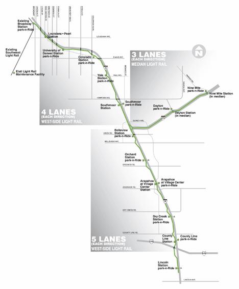
1 Preliminary Review of the T-REX Southeast Corridor Highway and Light Rail Transit Project DRCOG Congestion Mitigation Program White Paper 07-1 (February 16, 2007) On time and under budget! Festivities were held in November 2006 as the Denver region saw the completion of the largest single congestion and mobility project in its history T-REX, or the Transportation Expansion Project. Commuters, visitors, and business are now able to use light rail transit or new highway lanes to travel along the I-25 and I-225 corridors. The Colorado Department of Transportation (CDOT) and Regional Transportation District (RTD) worked cooperatively to get this major project completed in a highly efficient manner. It is a shining example for the rest of the country. A lot of media attention has been given to describing congestion and comparing Southeast Corridor travel times (before and after, rail vs. car, rail vs. bus). Final conclusions on travel times, delay, and congestion cannot yet be reached due to holiday traffic patterns and December s snowy weather, but benefits surely have been achieved. So what are the benefits of T-REX? This paper describes some of the initial benefits and discusses future analyses of benefits to be conducted by RTD. Background The need for rapid transit service and highway capacity improvements in the Southeast Corridor has been clearly noted in the regional transportation plans since The 1979 State Implementation Plan for air quality (carbon monoxide) also identified light rail along I-25 as a Transportation Control Measure to help reduce motor vehicle pollutant emissions. The completion date was set for However, funding for project was not obtained. The highway and light rail project was further solidified through a major investment study (MIS) completed in The Southeast Corridor MIS identified a light rail transit project along about 15 miles of I-25 from Broadway to Lincoln Avenue in Douglas County and 5 miles of I-225 from I-25 to Parker Road (SH-83). Recommendations for the highway included drainage, shoulder, interchange, and minor auxiliary lane improvements. In 1999 funding was finally approved by local voters to construct the light rail transit line and by statewide voters to add new travel lanes to I-25 and I-225 along the entire length of the project. Shortly thereafter, the DRCOG Board approved the light rail line through the Senate Bill 208 approval process and an Environmental Impact Statement was completed in Construction on the newly named T-REX project began in 2001 amid newspaper headlines predicting highway hell for the next seven years. Contrary to this prediction, the general consensus was that the construction impacts were relatively minor, especially when compared to other major national projects such as the I-15 project in Salt Lake City and the infamous Big Dig project in Boston. T-REX was completed by Southeast Corridor Constructors, a joint venture between Kiewit Construction and Parsons Transportation Group, within the original $1.67 billion budget and in less than six years rather than seven years. The project became a shining example across the country of an efficient and cooperatively managed major transportation project. CDOT, RTD, local governments, residents, and businesses worked closely together to enable the opening of the light rail transit and all new travel lanes by November
2 2
3 What Did T-REX Include? Transit: A 19-mile-long double-tracked light rail line was constructed starting at the existing I-25/Broadway station. Thirteen new rail stations were built, including over 7,500 motor vehicle parking spaces, 88 bicycle lockers, and racks to hold 90 bicycles. Pedestrian crossing bridges were provided at several stations, with one additional set to open over the next year. Four specific new rail routes (E, F, G, and H) were established to provide service parallel to I-225 and I-25 and connect to Lower Downtown (Denver Union Station) and Central Downtown (Stout Street and California Street) Bus service operation changes were also made to coincide with the light rail line. Many bus routes were terminated at light rail stations to act as feeder routes. This has been the source of some concern from previous riders who traveled on a single vehicle to reach downtown Denver, but now are required to transfer to a train. RTD is evaluating the connections and transfer times for these trips. Another key bus service change was the provision of seven new call-n-ride service areas. Highway: I-25 and I-225 were widened from their previous design. In general, one new through-lane and one auxiliary lane (between on-ramps and off-ramps) were added in each direction. For I-25 south of Belleview Avenue, two through-lanes were added in each direction. The complete interchange of I- 25 and I-225 was reconstructed, as were six additional interchanges and several ramps connecting to arterial streets along the corridor. It should be noted that two adjacent complementary projects that were not a part of T-REX were also completed recently the I-25 bridge over Broadway, and the Parker Road/I-225 interchange. Management and Operations: The T-REX Project partnered with businesses, DRCOG, and other transportation organizations to develop the TransOptions program. Through the T-REX Web site, special events, and outreach efforts, TransOptions supported or encouraged carpooling, vanpooling, transit, teleworking, walking and bicycling as means to reduce the impacts of the construction on the traveling public. The benefits of introducing people and businesses to these commuting options during the construction should extend well into the future. Numerous intelligent transportation systems (ITS) devices and systems were installed during the T- REX construction to help manage traffic, respond to incidents, and provide real-time information to travelers. Closed-circuit television cameras, dynamic message signs, vehicle detection systems, and ramp meters were installed and are monitored and operated through the CDOT Traffic Management Center. ITS applications were also installed in conjunction with the light rail stations including parking facility use monitoring, bus and train arrival/departure information, and transit signal priority at exits from stations. 3
4 What Are the Impacts of T-REX? The completion of the T-REX project has resulted in many impacts. Some are already evident and are discussed below. However, some impacts will not be known for some time. For example, a couple of years of data will be needed before determining the impact on the number and rate of traffic crashes (aka accidents ). We ll also need to account for extreme weather conditions that may have caused abnormalities in the number of crashes. It should be noted that for each of the questions and responses discussed below, additional information must be collected and analyzed before reaching final conclusions. It will take time for all of the freeways and arterials in the corridor area to reach equilibrium as travelers adjust their typical travel routes after becoming familiar with the travel time changes and new transit options. Traffic Congestion and Travel Times Within weeks after the opening of the new travel lanes on I-25 and I-225, the media began reporting on travel time and speed changes. Over the next year RTD and CDOT will be concluding a before and after study that thoroughly analyzes the changes in travel patterns due to T- REX. In the meantime, DRCOG has compiled initial field measurements and results from the Congestion Mitigation Program database to take a preliminary look at post-t-rex travel changes. Has traffic congestion been eliminated? Not entirely. For the overall corridor, measures of congestion have improved and the Southeast light rail line has provided a new travel option to people living or working along the corridor. However, on average, I-25 and I-225 still carry nearly 200,000 and 120,000 vehicles respectively per day. With those volumes of traffic there is bound to be some congestion. Does traffic congestion occur for a shorter period of time each day? Yes. One consideration for evaluating congestion is the length of time, or duration, of congested conditions on a typical day. Clearly, on average in the peak periods, congested conditions now begin a little later and end a little earlier. Have average highway travel times been reduced? Yes, and this is directly related to average increased travel speed. Before and after travel times are presented in the table below. On average, it appears that the travel time for vehicles traveling the entire length of I-25 in the peak hour are 10 minutes less than before T-REX. Travel Time Estimates: I-25 from Lincoln Avenue (Douglas County) to Broadway Off-Peak PM Peak Hour (minutes) Before and After (Free-Flow) DRCOG CDOT Denver T-REX (minutes) CMP Study Post Average Travel Time Before Travel Time After x
5 Someone traveling the entire length of the project will normally experience these results, but conditions will vary day by day. Short distance trips along specific portions of the corridor will not reap the entire benefits. For example, a driver who enters northbound I-25 from University Boulevard and travels through past Broadway may have minimal benefits. Where does the most severe and longest duration of congestion continue to occur? Northbound I-25 approach to Broadway/Santa Fe: This is a key bottleneck location where the number of northbound through-lanes decreases from 4 to 3 lanes just prior to the Santa Fe Drive on-ramp; Off-ramps of some major interchanges: At certain time periods, the storage capacity of offramps is exceeded. It is important to prevent vehicles from queuing up back to the freeway. The timing of traffic signals at the off-ramp intersections will be monitored and adjusted to provide adequate green-light time to move the traffic through and reduce such back-ups; and Southbound I-225 approach to I-25: This is one of the busiest three-way freeway interchanges in the country. More than 50,000 vehicles per day travel from I-225 on to I- 25. So even with the T-REX improvements, some congestion is bound to occur. Are more cars traveling on I-25 and I-225? Over time it is very likely that traffic volumes will increase. This would be due to overall regional growth and shifting of travel paths. As motorists learn about the improved travel times on the freeways, the route for some trips may shift from parallel side streets (e.g. Quebec Street and University Boulevard). This could provide benefits to those streets. Because of the extreme winter weather conditions and short time since T-REX was completed, conclusive results are not yet available. The RTD before-and-after study referenced earlier will provide results later in the year. Are more people riding in transit vehicles? Preliminary data indicate that overall transit ridership has increased substantially in the Southeast Corridor. Free-Flow Travel Speeds Following the widening of I-25 south of I-225, the posted speed limit was raised from 55 mph to 65 mph. This factor alone would decrease legal travel times on I-25 through the Denver Tech Center area by at least 5 minutes. Though increases in speed limits are generally implemented in response to existing free-flow travel speeds, some increase in overall average travel speeds may occur. Monitoring of conditions and speeds by CDOT, the Colorado State Patrol, and local law enforcement agencies will continue. Through enforcement and other efforts, unsafe travel speeds can be discouraged. Transit Trip Times Transit along the Southeast Corridor light rail line has offered lower travel times to most, but not all transit users. It offers better reliability and a significant increase in vehicle capacity to handle a higher number of riders. RTD is still working out some of the technical and operational kinks, just as with any new product or service. Some commuters that previously used bus routes that traveled directly to downtown Denver have faced longer commute time because of required transfers onto the light rail line. Adjustments to the bus routes may be considered by RTD to respond to concerns from large markets of riders. In many typical instances, door-to-door travel times are comparatively longer via transit than driving a car. But commuters consider many other factors in deciding how to travel. Parking and fuel costs, vehicle wear and tear, stress, reliability, trip requirements, and weather conditions are 5
6 among many of the factors considered. Periodic incidents related to weather, crashes, construction, and lane closures will greatly increase travel times on the highway with minimal impact on light rail. Mechanical failures on light rail tracks and vehicles do occur, but much less frequently than highway incidents. Thus, there is no definitive answer for determining the better mode of travel. Conclusion Time will tell the entire story of the impacts of T-REX. The following factors will influence the story, but may not be evident for several months or even years: Drivers adjusting travel routes; Travelers switching travel modes (transit, carpooling, etc.); Entirely new trips or longer trips being made because of decreased travel time and improved transit service; Price and supply of gasoline; Popularity of existing housing near transit stations to different demographic populations; Construction of new housing units near transit stations; Maturing of transit oriented developments (TODs) at transit stations; Business and personal cultural shifts that encourage teleworking; and Overall economic and population growth in the corridor, region, and state. To learn more about T-REX, Southeast Corridor light rail, and day-to-day travel information and travel options in the Southeast Corridor visit the following Web sites: T-REX: RTD: CDOT traveler information (cameras, message signs, travel times, etc.): DRCOG RideArrangers (carpool, vanpool, telework, travel options): Southeast Business Partnership (travel options and assistance): 6
Regional Transportation Needs Within Southeastern Wisconsin
 Regional Transportation Needs Within Southeastern Wisconsin #118274 May 24, 2006 1 Introduction The Southeastern Wisconsin Regional Planning Commission (SEWRPC) is the official areawide planning agency
Improving Mobility Without Building More Lanes
 Improving Mobility Without Building More Lanes By Mike Salisbury and Will Toor July 2017 Copyright 2017 by Southwest Energy Efficiency Project. All rights reserved. Photo: Courtesy of the Denver Post Anyone
Congestion Reducing Activities. Toby Carr GDOT Director of Planning April 10, 2014
 Congestion Reducing Activities Toby Carr GDOT Director of Planning April 10, 2014 GDOT Performance Dashboard Congestion Congestion Relief Strategies 511 HEROS RTOP Highway Emergency Response Operators
1. Operate along freeways, either in regular traffic lanes, in high-occupancy vehicle (HOV) lanes, or along the shoulders.
 lanes, or along the shoulders.") Most decisions about whether or not to use transit involve time and cost, and most transit services are slower than travel by private vehicle. However, when transit is faster or nearly as fast as travel
Most decisions about whether or not to use transit involve time and cost, and most transit services are slower than travel by private vehicle. However, when transit is faster or nearly as fast as travel
Appendix C. NORTH METRO STATION AREA TRAFFIC IMPACT STATEMENT 88th Avenue Station
 Appendix C NORTH METRO STATION AREA TRAFFIC IMPACT STATEMENT 88th Avenue Station Prepared for: Regional Transportation Department and URS Corporation as part of the North Metro EIS David Evans and Associates,
MCTC 2018 RTP SCS and Madera County RIFP Multi-Modal Project Eval Criteria GV13.xlsx
 MCTC 8 RTP SCS and Madera County RIFP Multi-Modal Project Eval Criteria GV.xlsx Madera County Transportation Commission Regional Transportation Plan / Sustainable Communities Strategy Multi-Modal Project
395 Express Lanes Extension
 395 Express Lanes Extension January 2016 Building a network of Express Lanes Project overview Add capacity on I-395 with addition of a third HOV lane and active traffic management Generate guaranteed transit
2. Context. Existing framework. The context. The challenge. Transport Strategy
 Transport Strategy Providing quality connections Contents 1. Introduction 2. Context 3. Long-term direction 4. Three-year priorities 5. Strategy tree Wellington City Council July 2006 1. Introduction Wellington
Technical Working Group November 15, 2017
 Technical Working Group November 15, 2017 Welcome and Introductions Project Partners Regional Transportation District (RTD) Colorado Department of Transportation (CDOT) Denver Regional Council of Governments
SPEED MANAGEMENT FOR VISION ZERO
 SPEED MANAGEMENT FOR VISION ZERO LUANN HAMILTON, DEPUTY COMMISSIONER FOR PROJECT DEVELOPMENT CHICAGO DEPARTMENT OF TRANSPORTATION NACTO DESIGNING CITIES 2017 Vision Zero Action Plan Speed management and
Bus Rapid Transit ALTERNATIVES ANALYSIS. Open House
 Bus Rapid Transit ALTERNATIVES ANALYSIS Open House June 23, 2015 Open House Meeting Agenda Agenda Introductions What is BRT? Project Goals Study Tasks Next steps Discussion PVTA Bus Rapid Transit Study
4 DISRUPTION MANAGEMENT PLAN HIGHWAY 7 RAPIDWAY CONSTRUCTION BETWEEN BAYVIEW AVENUE AND WARDEN AVENUE TOWNS OF MARKHAM AND RICHMOND HILL
 4 DISRUPTION MANAGEMENT PLAN HIGHWAY 7 RAPIDWAY CONSTRUCTION BETWEEN BAYVIEW AVENUE AND WARDEN AVENUE TOWNS OF MARKHAM AND RICHMOND HILL The Transportation Services Committee recommends the adoption of
Highway 217 Corridor Study. Phase I Overview Report
 Highway 217 Corridor Study Phase I Overview Report November 3, 24 BACKGROUND AND OVERVIEW Study purpose The Highway 217 Corridor Study is developing multi-modal transportation solutions for traffic problems
Purpose and Need. Chapter Introduction. 2.2 Project Purpose and Need Project Purpose Project Need
 Chapter 2 Purpose and Need 2.1 Introduction The El Camino Real Bus Rapid Transit (BRT) Project (Project) would make transit and other transportation improvements along a 17.6-mile segment of the El Camino
University Hill Transportation Study Technical Memorandum Alternatives Modeling and Analysis May 2007
 Technical Memorandum May 2007 Syracuse Metropolitan Transportation Council Edwards and Kelcey with Wallace Roberts and Todd Alta Planning and Design CONTENTS SECTION ONE- INTRODUCTION...1 SECTION TWO-
A District Council of the Urban Land Institute
 A District Council of the Urban Land Institute Thank you to our sponsors! A District Council of the Urban Land Institute Thank you to our Community Partners! A District Council of the Urban Land Institute
# Southeastern Wisconsin Regional Freeway System Reconstruction Study and Preliminary Recommended Plan
 #70421 Southeastern Wisconsin Regional Freeway System Reconstruction Study and Preliminary Recommended Plan Public Information Meetings and Hearings May June 2002 1 Reason for Freeway System Study 270-mile
I-25 South Gap Project Monument to Castle Rock
 I-25 South Gap Project Monument to Castle Rock Project Overview Castle Rock Town Council April 3, 2018 by Chuck Attardo I-25 South: Monument to C-470 An Important Corridor to Colorado Links the state s
ROUTES 55 / 42 / 676 BUS RAPID TRANSIT LOCALLY PREFERRED ALTERNATIVE
 ROUTES 55 / 42 / 676 BUS RAPID TRANSIT LOCALLY PREFERRED ALTERNATIVE April, 2012 1 INTRODUCTION The need for transit service improvements in the Routes 42/55/676 corridor was identified during the Southern
4. ENVIRONMENTAL IMPACT ANALYSIS 9. TRANSPORTATION AND TRAFFIC
 4. ENVIRONMENTAL IMPACT ANALYSIS 9. TRANSPORTATION AND TRAFFIC 4.9.1 INTRODUCTION The following section addresses the Proposed Project s impact on transportation and traffic based on the Traffic Study
Community Task Force July 25, 2017
 Community Task Force July 25, 2017 Welcome and Introductions Project Partners Regional Transportation District (RTD) Colorado Department of Transportation (CDOT) Denver Regional Council of Governments
95 Express Annual Operations Report: Fiscal Year
 95 Express Annual Operations Report: Fiscal Year 2014-2015 General The 95 Express Program completed its sixth full Fiscal Year of operations in June 2015. For the FDOT, its Fiscal Year (FY) is from July
Highway 17 Transportation Improvement Study
 Final Report Highway 17 Transportation Improvement Study prepared for Santa Cruz County Regional Transportation Commission (SCCRTC) prepared by Planning and Engineering, Inc. 1155 North First Street, Suite
Shenango Valley MPO. State Transportation Commission 2015 Twelve Year Program Development
 State Transportation Commission 2015 Twelve Year Program Development Regional results of the survey and public feedback from August thru November 2013 Shenango Valley MPO Version 01-2014 Mobility Concerns
Community Task Force November 15, 2017
 Community Task Force November 15, 2017 Welcome and Introductions Project Partners Regional Transportation District (RTD) Colorado Department of Transportation (CDOT) Denver Regional Council of Governments
North Coast Corridor:
 North Coast Corridor: Connecting People, Transportation & Environment Legislative Hearing: 11.8.10 1 North Coast Corridor Region s Lifeline A Regional Strategy Mobility, Economy & Environment North Coast
Chapter 6 Transportation Plan
 Chapter 6 Transportation Plan Transportation Plan Introduction Chapter 6 Transportation Plan Transportation Plan Introduction This chapter describes the components of Arvada s transportation system, comprised
METHODOLOGY. Signalized Intersection Average Control Delay (sec/veh)
") Chapter 5 Traffic Analysis 5.1 SUMMARY US /West 6 th Street assumes a unique role in the Lawrence Douglas County transportation system. This principal arterial street currently conveys commuter traffic
Chapter 5 Traffic Analysis 5.1 SUMMARY US /West 6 th Street assumes a unique role in the Lawrence Douglas County transportation system. This principal arterial street currently conveys commuter traffic
State Highway 16 Kuna-Mora Road to Ada/Gem County Line
 Background Update! (February 2018): This project has been partially funded; see below. State Highway 16 is the main commuter route from Gem County to the Treasure Valley. An increase in traffic and accidents
Managed Lanes. Steve Schilke, P.E. Major Projects Unit Head District 1. Illinois Traffic Engineering and Safety Conference October 2016
 Managed Lanes Steve Schilke, P.E. Major Projects Unit Head District 1 Illinois Traffic Engineering and Safety Conference October 2016 Agenda Managed Lanes Projects I-55 (Stevenson Expressway) Express Toll
Maryland State Highway Mobility Report. Morteza Tadayon
 Maryland State Highway Mobility Report Morteza Tadayon Background Mobility is a Key Performance Area (KPA) in the SHA Business Plan SHA adopts a performance based approach Monitors Highway System to identify
Santa Clara I-280 CORRIDOR STUDY
 Santa Clara I-280 CORRIDOR STUDY OCTOBER 2017 PREPARED BY: 1.1 Background The I-280 Corridor Study within Santa Clara County is a high-level highway planning study led by the Santa Clara VTA, in partnership
Memorandum. Fund Allocation Fund Programming Policy/Legislation Plan/Study Capital Project Oversight/Delivery Budget/Finance Contract/Agreement Other:
 Memorandum Date: November 20, 2017 To: Transportation Authority Board From: Eric Cordoba Deputy Director Capital Projects Subject: 12/5/17 Board Meeting: San Francisco Freeway Corridor Management Study
Solana Beach Comprehensive Active Transportation Strategy (CATS)
") Solana Beach Comprehensive Active Transportation Strategy (CATS) 3.0 Goals & Policies The Solana Beach CATS goals and objectives outlined below were largely drawn from the Solana Beach Circulation Element
Solana Beach Comprehensive Active Transportation Strategy (CATS) 3.0 Goals & Policies The Solana Beach CATS goals and objectives outlined below were largely drawn from the Solana Beach Circulation Element
Congestion Management Report
 Congestion Management Report F.E. EVERETT TURNPIKE (NORTH), MERRIMACK Segment Length: 7.0 miles Daily Traffic Volumes: 60,000-69,000 Analysis Period: May 2015 Number of Traffic Signals: 0 Number of travel
Tunnel Reconstruction Brooklyn CB 1 August 14, 2018
 Tunnel Reconstruction Brooklyn CB 1 August 14, 2018 Reconstructing the Tunnel 2 Service During Tunnel Reconstruction April 2019 through July 2020 3 Projected Cross River Travel Paths of Customers The Service
EXECUTIVE SUMMARY... vii 1 STUDY OVERVIEW Study Scope Study Area Study Objectives
 Contents EXECUTIVE SUMMARY... vii 1 STUDY OVERVIEW... 1-1 1.1 Study Scope... 1-1 1.2 Study Area... 1-1 1.3 Study Objectives... 1-3 2 EXISTING CONDITIONS... 2-1 2.1 Existing Freeway Conditions... 2-4 2.1.1
State Highway 16 Kuna-Mora Road to Ada/Gem County Line
 Background State Highway 16 is the main commuter route from Gem County to the Treasure Valley. An increase in traffic and accidents on this highway have been a concern for several years, and the Idaho
Preliminary Transportation Analysis
 Preliminary Transportation Analysis Goals of a Robust, Multimodal Transportation Network Safe Accessible/Connected Efficient Comfortable Context-Sensitive Motor Vehicle: Continue to analyze the data to
Congestion Management Report
 Congestion Management Report DANIEL WEBSTER HIGHWAY, MERRIMACK Segment Length: 9.9 miles Daily Traffic Volumes: 13,000-21,000 Analysis Period: July August 2015 Number of Traffic Signals: 14 Number of travel
State Highway 16/McDermott Road Kuna-Mora Road to Ada/Gem County Line
 Background State Highway 16 is the main commuter route from Gem County to the Treasure Valley. An increase in traffic and accidents on this highway have been a concern for several years, and the Idaho
ITS-NY ANNUAL MEETING Bus Rapid Transit in New York City: Bus Lane Operations on One-Way Arterial Streets
 ITS-NY ANNUAL MEETING Bus Rapid Transit in New York City: Bus Lane Operations on One-Way Arterial Streets June 9, 2011 Ted Orosz AICP, Director Long Range Bus Planning MTA New York City Transit 1 Overview
Parks Highway: MP Lucus Road to Big Lake Road
 2 Purpose and Need 2.1 Corridor History The Parks Highway is a 324-mile long Rural Interstate Highway that extends from its intersection with the Glenn Highway north to Fairbanks, Alaska. The Parks Highway
LSC TRANSPORTATION CONSULTANTS, INC. 516 North Tejon Street Colorado Springs, CO (719) FAX (719)
 FAX (719)") LSC TRANSPORTATION CONSULTANTS, INC. 516 North Tejon Street Colorado Springs, CO 80903 (719) 633-2868 FAX (719) 633-5430 E-mail: lsc@lsccs.com May 15, 2009 Mr. Davis Farrar Western Slope Consulting, LLC
LSC TRANSPORTATION CONSULTANTS, INC. 516 North Tejon Street Colorado Springs, CO 80903 (719) 633-2868 FAX (719) 633-5430 E-mail: lsc@lsccs.com May 15, 2009 Mr. Davis Farrar Western Slope Consulting, LLC
Key objectives of the survey were to gain a better understanding of:
 3 COMMUNITY INPUT Community input is an essential part of corridor studies. For the SR 87 corridor study, VTA staff conducted an extensive online survey of people living and commuting along the corridor.
Circulation in Elk Grove includes: Motor vehicles, including cars and trucks
 Circulation, as it is used in this General Plan, refers to the many ways people and goods move from place to place in Elk Grove and the region. Circulation in Elk Grove includes: Motor vehicles, including
I 10 Phoenix to California Border Multimodal Corridor Profile Study
 I 10 Phoenix to California Border Multimodal Corridor Profile Study December 2012 Prepared by Arizona Department of Transportation 206 S. 17th Ave. Phoenix, AZ 85007 In cooperation with U.S. Department
Capital Beltway HOT Lanes - Frequently Asked Questions
 Capital Beltway HOT Lanes - Frequently Asked Questions December 20, 2007 1. What is the cost of the project? The fixed-price design-build cost is approximately $1.4 billion. 2. Why have the project costs
3.0 Future Conditions
 3.0 Future Conditions In order to be able to recommend appropriate improvements to the transportation system of the Town, it is important to first understand the nature and volume of traffic that is expected
State Road & Tollway Authority Georgia 400 Demolition Project Frequently Asked Questions
 State Road & Tollway Authority Georgia 400 Demolition Project Frequently Asked Questions 1. When will toll collection end? Toll collection is scheduled to end on Friday, November 22, weather permitting.
Community Task Force March 14, 2018
 Community Task Force March 14, 2018 Welcome and Introductions Project Partners Regional Transportation District (RTD) City of Aurora Colorado Department of Transportation (CDOT) Denver Regional Council
Freeway Improvement Project
 CapCity Corridor History and Milestones CapCity Partners CapCity Origin and Destination analysis Origins and Destinations Destinations based on Origins North of I-80 8% O & D data prepared by SACOG Origins
Chapter 7. Transportation. Transportation Road Network Plan Transit Cyclists Pedestrians Multi-Use and Equestrian Trails
 Chapter 7 Transportation Transportation Road Network Plan Transit Cyclists Pedestrians Multi-Use and Equestrian Trails 7.1 TRANSPORTATION BACKGROUND The District of Maple Ridge faces a number of unique
North Shore Transportation Improvement Strategy
 North Shore Transportation Improvement Strategy Preliminary, Near-term Recommendation 2016 April Transportation Improvement Strategy (TIS) Comprehensive and Analytical A multi-modal transportation strategy
INTRODUCTION. The focus of this study is to reduce congestion and improve mobility for all modes of transportation. Figure ES-1 Study Corridor Map
 INTRODUCTION The I-280 Corridor Study is a highway planning study led by Santa Clara VTA, in partnership with the City of Cupertino and in coordination with other stakeholders in the study area. The study
Regional Travel Demand Management Strategic Plan
 Regional Travel Demand Management Strategic Plan Adopted November 16, 2005 THE DENVER REGIONAL COUNCIL OF GOVERNMENTS Regional Travel Demand Management Strategic Plan Adopted November 16, 2005 Regional
Southwest Bus Rapid Transit (SW BRT) Functional Planning Study - Executive Summary January 19 LPT ATTACHMENT 2.
 Functional Planning Study - Executive Summary January 19 LPT ATTACHMENT 2.") Southwest Bus Rapid Transit (SW BRT) Functional Planning Study - Executive Summary 2011 January 19 1 of 19 Introduction This executive summary presents the results of the Southwest Bus Rapid Transit (SW
Southwest Bus Rapid Transit (SW BRT) Functional Planning Study - Executive Summary 2011 January 19 1 of 19 Introduction This executive summary presents the results of the Southwest Bus Rapid Transit (SW
Regional Travel Demand Management Strategic Plan DRAFT
 Regional Travel Demand Management Strategic Plan DRAFT November 16, 2005 Regional Travel Demand Management Strategic Plan Table of Contents 1. Introduction A. TDM in DRCOG s Regional Plans B. Effects
Develop a Multi-Modal Transportation Strategy (Theme 6)
") DEVELOP A MULTI-MODAL TRANSPORTATION STRATEGY (THEME 6) WHY IS THIS THEME ADDRESSED? Develop a Multi-Modal Transportation Strategy (Theme 6) Statement of Ideal Reduce resident and visitor reliance on single
DEVELOP A MULTI-MODAL TRANSPORTATION STRATEGY (THEME 6) WHY IS THIS THEME ADDRESSED? Develop a Multi-Modal Transportation Strategy (Theme 6) Statement of Ideal Reduce resident and visitor reliance on single
7.0 FREEWAYS CONGESTION HOT SPOT PROBLEM & IMPROVEMENT PROJECT ANALYSIS & DEFINITION
 7.0 FREEWAYS CONGESTION HOT SPOT PROBLEM & IMPROVEMENT PROJECT ANALYSIS & DEFINITION 7.1 INTRODUCTION & METHODOLOGY FEASIBILITY REPORT Congestion hot spot problem locations have been assessed using the
Performance Criteria for 2035 Long Range Transportation Plan
 Minimizing Impacts on Natural, Historic, Cultural or Archeological Resources 2035 LRTP Weighting Factor: 7% Objective 1.1: Use appropriate planning and design criteria to protect and enhance the built
How To Encourage More Efficient Transportation in Brazilian Cities
 How To Encourage More Efficient Transportation in Brazilian Cities Todd Litman Victoria Transport Policy Institute Presented Seminar on Discouraging The Use Of Cars São Paulo, Brazil 3 September 2013 Creating
3.0 PROJECT DESCRIPTION
 The following section of the Draft EIR contains a description of the proposed Elk Grove Boulevard/SR 99 Interchange Modification project, consistent with the requirements of CEQA Guidelines Section 15124.
Eliminate on-street parking where it will allow for a dedicated bus only lane %
 Traffic Dashboard Priorities Survey Responses Introduction 1) Are you familiar with bus rapid transit (BRT)? a. No, BRT is new to me. 597 23.5% b. I ve heard of BRT, but I don t know much about it. 1,136
MOBILITY RESULTS AREA. Budgeting For Outcomes Council Presentation January 12, 2007
 MOBILITY RESULTS AREA Budgeting For Outcomes Council Presentation January 12, 2007 Mobility Results Team Members 2 Hammond Perot, OED, Co-Team Leader Bonnie Meeder, DEV (returning), Co-Team Leader Peer
STATION #3 INITIAL ALTERNATIVES
 www.dot.il.gov www.eisenhowerexpressway.com STATIO #3 IHB RR Heavy Rail Transit (HRT) High capacity transit mode serving urban areas:» Steel wheeled, high performance electric powered rail vehicles» Right-of-way
Bicycle - Motor Vehicle Collisions on Controlled Access Highways in Arizona
 Bicycle - Motor Vehicle Collisions on Controlled Access Highways in Arizona Analysis from January 1, 1991 to June 30, 2002 Richard C. Moeur, PE Traffic Design Manager, Northern Region Michelle N. Bina
TRANSPORTATION TRAINING TOPICS. April 6, 2010
 TRANSPORTATION TRAINING TOPICS April 6, 2010 Roles of Transportation Providers Context and Policy Makers Division of Transportation and Traffic Other City Operations Other Transportation Operators CMA
PEDESTRIAN ACTION PLAN
 ATTACHMENT 2 CITY OF SANTA MONICA PEDESTRIAN ACTION PLAN CITY OF SANTA MONICA PEDESTRIAN ACTION PLAN This page intentionally left blank EXECUTIVE SUMMARY CHAPTER 1 EXECUTIVE SUMMARY Setting the Stage
Planning Transit Operations and Bike Sharing Denver RTD. Bill Van Meter, Assistant General Manager, Planning March 23, 2012
 Planning Transit Operations and Bike Sharing Denver RTD Bill Van Meter, Assistant General Manager, Planning March 23, 2012 1 Overview RTD Background RTD Bike-n-Ride Program RTD - Bike Share Coordination:
Downtown BRT Corridor Alternatives Review: 1 st, 2 nd, 3 rd and 4 th Avenue. Bus Rapid and Conventional Transit Planning and Design Services
 Downtown BRT Corridor Alternatives Review: 1 st, 2 nd, 3 rd and 4 th Avenue Bus Rapid and Conventional Transit Planning and Design Services City of Saskatoon February 2018 Project Team HDR Corporation
El Paso County 2040 Major Transportation Corridors Plan
 El Paso County 2040 Major Transportation Corridors Plan Connect-our-County Online Transportation User Survey Preliminary Results June 24, 2010 Years of Residence 2. How many years have you LIVED HERE?
M14A/D Select Bus Service
 M14A/D Select Bus Service Manhattan Community Board 6: April 1, 2019 New York City Transit 2 Background M14 Select Bus Service M14 was identified as a critical future SBS corridor in past BRT studies as
Dear City Council Members,
 From: Bob Kenyon [mailto: ] Sent: Monday, February 08, 2016 10:20 AM To: City Clerk Subject: Please prioritize Caltrain and a complete transit network Thank you for prioritizing bringing BART to San Jose
INNOVATIVE INTERSECTION DESIGN
 INNOVATIVE INTERSECTION DESIGN J. Eddie Valtier, P.E. ELP TP&D Director Introduction Why Do We Need To Start Looking For Innovative Intersection Designs? Congestion is worsening and traffic volumes and
Typical Rush Hour Commute. PennyforTransportation.com
 Typical Rush Hour Commute In the News Overview of the Plan Collaborative plan with projects in every community Prioritizing connectivity and congestion relief Dedicated transportation-specific funding;
Base Information. 1. Project Title Parker/Quincy/Smoky Hill Intersection Improvements
 Part 1 Base Information 1. Project Title Parker/Quincy/Smoky Hill Intersection Improvements 2. Project Start/End points or Geographic Area Provide a map with submittal, as appropriate 3. Project Sponsor
SANTA CLARA COUNTY I-280 CORRIDOR STUDY
 SANTA CLARA COUNTY I-280 CORRIDOR STUDY Appendix D CrowdSpot Outreach Summary SANTA CLARA VALLEY TRANSPORTATION AUTHORITY (VTA) 1-1 Introduction Background I-280 Corridor Study project used Crowdspot mapping
REVIEW OF LOCAL TRAFFIC FLOW / LONG RANGE PLANNING SOLUTIONS STUDY
 ITEM Town of Atherton TRANSPORTATION COMMITTEE STAFF REPORT TO: FROM: MEMBERS OF THE COMMITTEE ROBERT OVADIA, PUBLIC WORKS DIRECTOR DATE: FEBRUARY 12, 2019 SUBJECT: REVIEW OF LOCAL TRAFFIC FLOW / LONG
Congestion Evaluation Best Practices
 Congestion Evaluation Best Practices Todd Litman Victoria Transport Policy Institute Presented International Transportation and Economic Development Conference 10 April 2014 Congestion Indicators Indicator
Simulating Street-Running LRT Terminus Station Options in Dense Urban Environments Shaumik Pal, Rajat Parashar and Michael Meyer
 Simulating Street-Running LRT Terminus Station Options in Dense Urban Environments Shaumik Pal, Rajat Parashar and Michael Meyer Abstract The Exposition Corridor transit project is a light rail project
State Highway 44/State Street High Capacity Corridor
 Background State Highway 44/State Street runs from I-84 in Canyon County through parts of the cities of Middleton, Star, Eagle, and Garden City to downtown Boise. It is a commuter route from several communities
Appendix T-2: Transportation Facilities Inventory
 Appendix T-2: Transportation Facilities Inventory Roads, Highways and Bridges The Georgia Department of Transportation (GDOT) maintains centerline mile measures for all counties in Georgia based on functional
SANTA MONICA BOULEVARD CORRIDOR
 CIRCULATION ELEMENT WHITE PAPER NO. 3 SANTA MONICA BOULEVARD CORRIDOR INTRODUCTION From the 1930s to the beginning of Los Angeles freeway era, Santa Monica Boulevard, (previously Route 66, the Beverly
ARTINSVILLE ENRY OUNTY REA RANSPORTATION TUDY
 ARTINSVILLE ENRY OUNTY REA RANSPORTATION TUDY DEVELOPED BY THE TRANSPORTATION AND MOBILITY PLANNING DIVISION OF THE VIRGINIA DEPARTMENT OF TRANSPORTATION IN COOPERATION WITH THE U.S. DEPARTMENT OF TRANSPORTATION,
SOLANA BEACH BICYCLE TRANSPORTATION PLAN SECOND ADDENDUM
 SOLANA BEACH BICYCLE TRANSPORTATION PLAN SECOND ADDENDUM Prepared by the City of Solana Beach January 2005 Introduction In June of 1993, the Solana Beach City Council adopted a Bikeway Master Plan as directed
Strategies to keep people and goods moving in and through Seattle
 Strategies to keep people and goods moving in and through Seattle The Seattle Squeeze and the #Realign99 Closure 2018-2024 Commute Seattle Employer Department Open of Transportation House December 7, 2018
New Seward and 36 th Avenue Intersection Conceptual Design
 University of Alaska Anchorage New Seward and 36 th Avenue Intersection Conceptual Design Prepared By: Zaid S. Hussein Dana Menendez Galen Jones Civil Engineering Department Prof. Osama Abaza CE A404 Highway
MULTIMODAL NEEDS ASSESSMENT
 5. PORTS OF ENTRY INTRODUCTION The El Paso MPO region is one of the most significant border crossing regions in the United States. Known as the world s largest international border metroplex, traffic and
Measuring the Distribution and Costs of Congestion. Tim Lomax Texas Transportation Institute
 Measuring the Distribution and Costs of Congestion Tim Lomax Texas Transportation Institute http://mobility.tamu.edu The Congestion Measurement Story Travel time, variations, compare to goals WHAT? WHY?
NORTH TURNAROUND. Recommended Design: Expand the existing transit terminal
 NORTH TURNAROUND Recommended Design: Expand the existing transit terminal Feedback from stakeholders and the public: Make it easy to transfer between local and Rapid Transit service Why is this design
Mission Bay Loop (MBL) Public Meeting
 Public Meeting") Mission Bay Loop (MBL) Public Meeting La Scuola Internazionale di San Francisco, November 18, 2014 Frequently Asked Questions 1. When would construction have to start before the SFMTA loses TIGER funds?
Mission Bay Loop (MBL) Public Meeting La Scuola Internazionale di San Francisco, November 18, 2014 Frequently Asked Questions 1. When would construction have to start before the SFMTA loses TIGER funds?
SETTINGS AND OPPORTUNITIES MOBILITY & ACCESS
 7 mobility & access how do people use el camino what is it like to drive on el camino/to park along el camino what is the pedestrian experience like what is the role of transit along the corridor what
Corpus Christi Metropolitan Transportation Plan Fiscal Year Introduction:
 Introduction: The Safe, Accountable, Flexible, Efficient Transportation Equity Act: A Legacy for Users (SAFETEA-LU) has continued the efforts started through the Intermodal Surface Transportation Efficiency
Welcome to the McKenzie Interchange Project Open House!
 Welcome to the McKenzie Interchange Project Open House! Purpose of Open House To provide you with information regarding the project and for you to have the opportunity to share your input on design concepts.
Bluffdale South (SR140) Bicycle/Shoulder Lanes Project Type Bicycle
 Bicycle/Shoulder Lanes Project Type Bicycle") Bluffdale 14600 South (SR140) Bicycle/Shoulder Lanes Project Type Bicycle From Pony Express to UPRR Bridge over SR-140 $ 669,700 $ 624,361 To build bicycle/shoulder lanes on SR-140. SR-140 is an official
Bluffdale 14600 South (SR140) Bicycle/Shoulder Lanes Project Type Bicycle From Pony Express to UPRR Bridge over SR-140 $ 669,700 $ 624,361 To build bicycle/shoulder lanes on SR-140. SR-140 is an official
2016 Northwest Metro Region Mobility Report. July 2018
 2016 Northwest Metro Region Mobility Report July 2018 Table of Contents Executive Summary... 6 US 36 Express Lanes Project... 6 2015 US 36 Communities Transportation Mode Share... 7 Preliminary Outcomes
Transportation Master Plan Advisory Task Force
 Transportation Master Plan Advisory Task Force Network Alternatives & Phasing Strategy February 2016 BACKGROUND Table of Contents BACKGROUND Purpose & Introduction 2 Linking the TMP to Key Council Approved
Public Information and Participation Comments
 Two public meetings were held in December. The first meeting was December 6, 2011 at Mary Ellen Henderson Middle School and had 36 public attendees. The second meeting was on December 14, 2011 at the Arlington
Corporate. Report COUNCIL DATE: June 26, 2006 NO: C012 COUNCIL-IN-COMMITTEE. TO: Mayor & Council DATE: June 22, 2006
 Corporate NO: C012 Report COUNCIL DATE: June 26, 2006 COUNCIL-IN-COMMITTEE TO: Mayor & Council DATE: June 22, 2006 FROM: General Manager, Engineering FILE: 0410-20(MoT/Gate) SUBJECT: Surrey Response on