Approved Developed by WILMAPCO. In partnership with The Town of Perryville, Maryland Cecil County
|
|
|
- Aubrey Nichols
- 5 years ago
- Views:
Transcription

1 A Plan for Walking and Bicycling in the Town of Perryville PERRYVILLE GREENWAY PLAN Developed by WILMAPCO In partnership with The Town of Perryville, Maryland Cecil County With technical assistance from Design Collective Approved
2 CONTENTS Introduction... 1 Goals and Objectives... 1 Why We Developed A Perryville Greenway Plan... 3 Transportation Benefits... 4 Environmental Benefits... 5 Economic Benefits... 5 Health and Quality of Life Benefits... 6 Existing Conditions... 7 Current Challenges... 7 Fragmented Sidewalk Network... 7 Barriers and Difficult Crossings... 7 Lack of Designated Bicycle Facilities... 9 Other Challenges... 9 Current Opportunities Regional Greenway Routes Other Opportunities Recommended Pedestrian, Bicycle and Greenway Route Network Strategies and Actions Develop a coordinated network that is safe, accessible, convenient and provides intermodal connections Increase the use of walking and bicycling for transportation Expand bicycle, pedestrian and greenway accessibility and connectivity Foster intermodal linkages and amenities to support trips by walking and cycling Provide end of trip facilities for bicyclists and Greenway users Use best practices for engineering safe trail, sidewalk and bicycle facilities Maintain existing trails Expand partnerships and coordination to support walking and bicycling Funding, Implementation and Evaluation Funding Maintenance and Management Plan Organizational Strategies Greenway Maintenance Requirements Sidewalk Maintenance Requirements Bicycle Route Maintenance Requirements Evaluation Adopted by the Perryville Mayor and Commissioners on March 6, 2012 Endorsed by the WILMAPCO Council March 8, 2012 The preparation of this document was financed in part with funds provided by the Federal Government, including the Federal Transit Administration and the Federal Highway Administration of the United States Department of Transportation.


3 Introduction 1 INTRODUCTION The Town of Perryville recognizes that bicycling and walking enhance the quality of life for residents, commuters and visitors, and that safe routes should connect neighborhoods, parks, schools, transit and commercial areas. Developed in coordination with the Perryville Transit Oriented Development (TOD) Plan, this Greenway Plan provides a coordinated and strategic approach to the development of a network of off-road bicycle and pedestrian greenways, and connecting sidewalks and bicycle routes. Located along the Lower Susquehanna Heritage Greenway and East Coast Greenway, the Town of Perryville is interested in expanding facilities for walking and bicycling for local transportation, recreation and regional tourism. The Plan identifies projects and strategies to improve quality of life for residents and visitors by expanding transportation choice and opportunities, providing safe, healthy and convenient facilities for pedestrian and bicycle commuting and recreation for residents and visitors of all ages. The Town will increase walking and bicycling use and safety by providing a network with links to other modes of transportation, and developing education programs and encouragement activities. This Plan seeks to guide the enhancement of greenways, bicycle routes and pedestrian facilities in Perryville by: Identifying best practices and their possible use in Perryville Evaluating existing conditions and identifying gaps in the network Identifying potential greenways, sidewalks, and bike routes that include links to other modes of transportation Proposing programs, policies and projects for fostering development, maintenance and use of the network Identify possible funding sources and partnerships This Plan is guided by state, local and regional policies and was developed under the direction of the Town s Greenway Committee, comprised of local elected officials, nonprofits, Town staff and residents. GOALS AND OBJECTIVES Goals and objectives of this Plan include: Increase Walking and Bicycling for Transportation: Enhance the user experience as well as access to schools, places of employment, shopping, parks and recreation, natural areas, community centers and other key destinations: Expand greenway accessibility and connectivity Foster intermodal linkages and amenities to support trips by walking and cycling Integrate walking and bicycling with public transit facilities and services Provide adequate and secure bicycle parking at all major trip destinations Provide capital and engineered safety enhancements for safe travel across the town s nonmotorized network Maintain existing trails
4 2 Perryville Greenway Plan Develop a Coordinated Network for Walking and Bicycling That is Safe, Accessible, Convenient and Provides Intermodal Connections: Systematically develop and enhance greenways, sidewalks and bike routes where residents and visitors live, learn, work, and play: Explore greenway development in underutilized rail and utility corridors Focus greenway development on linkages with existing infrastructure Provide safely designed, well-marked and maintained on and off street bicycle routes Integrate greenways into existing communities Promote greenway design standards Routinely inventory greenway, pedestrian and bicycling assets Expand Partnerships and Coordination to Support Walking and Bicycling: Facilitate collaborative relationships among stakeholder groups and pursue new approaches to promoting greenway, sidewalk and bicycle route development: Attract state agency, local, and non-traditional partners in greenway development and promotion Practice coordinated inter-agency and inter-jurisdictional planning Incorporate pedestrian and bicycle elements into planning and development activities Refine roles and responsibilities of state agencies, the Town government and outside stakeholders Engage in innovative marketing and outreach techniques Provide connectivity to county, regional and national bicycle and greenway routes Teach children and adults safe bicycling techniques and motor vehicle operations Provide enforcement of traffic laws related to bicycling and pedestrians Maximize resources to support private and nonprofit sponsors Foster preplanning and engineering to address future maintenance needs The 2010 Town of Perryville Comprehensive Plan laid out a vision and strategies for a walkable, transit-friendly community. This Plan supports several strategies from the 2010 Town of Perryville Comprehensive Plan including: Link the residential, commercial and tourism sites through expansion of the transportation network Encourage use of public transit the MARC Train System Plan for improvements to existing and creation of new pedestrian access to the waterfront. Within this strategic context the Town has established the following priority initiatives: o Perryville Boat Ramp o Boardwalk along the shore at Rodgers Tavern o Greenway Trail System o Sidewalk retrofit along MD 7 o Improvements to the Perryville Community Park Objectives in the Comprehensive Plan s transportation section include the following that are addressed by this Plan: Provide a balance of transportation facilities meeting the needs of Perryville Coordinate various modes of transportation so that they complement each other Improve pedestrian and bicycle opportunities in the Town Provide adequate transportation network with minimal Town expense Maximize the desired use of transportation systems while minimizing possible effects upon neighborhoods, the environment and the general public In conjunction with County efforts, encourage the improvement of an efficient, convenient public transportation system to serve the specialized needs of residents and encourage new development and redevelopment activities to facilitate pedestrian and non-vehicular traffic or to integrate with public transportation systems
5 Introduction 3 WHY WE DEVELOPED A PERRYVILLE GREENWAY PLAN Walking and bicycling facilities are an important part of Perryville s community, serving not only as a low-cost means of transportation, but providing economic, environmental, health and quality of life benefits. GREENWAYS, SIDEWALKS AND BIKE ROUTES CONTRIBUTE TO STATE, REGIONAL AND LOCAL GOALS Transportation Expand travel choices Support transit Reduce congestion Affordable infrastructure Health & quality of life Support healthy, active lifestyles Provide recreation Inspire community pride Greenways, sidewalks and bike routes Environment Achieve smart growth Improve air quality Access nature & historic resources Economic Development Support local business Attract new business Promote tourism Increase land value Source: Adapted from 2009 Maryland Trails: Strategic Implementation Plan

6 4 Perryville Greenway Plan TRANSPORTATION BENEFITS Primary transportation benefits of walking and bicycling include: i) Expanded travel choices ii) Support for transit iii) Reduced congestion iv) Provides affordable infrastructure Pedestrian and bicycle facilities both parallel to roads and along greenways are a necessary part of the transportation system in Perryville and the surrounding region. Walking is the most basic form of transportation, and almost everyone is a pedestrian. Walking and bicycling are ideal, but underused, modes of travel for short trips between where we live, work, learn, shop, and play. Facilities to walk and bike are particularly critical for transit riders, those too young to drive, those for whom physical or financial conditions limit the ability to drive, and those choosing not to drive. According to the Census Bureau, 19 percent of Perryville residents are younger than age 16 and 8 percent of Perryville households have no vehicle available 1. Fostering transit-oriented development and convenient transit service requires good pedestrian and bicycle access around the train station and bus stops. Ridership on Cecil County Community Transit and the Perryville MARC service has seen steady increases in recent years. Bus transit riders depend on walking to access bus stops and destinations. Cecil County Community Transit is also in the process of adding bike racks to buses which will allow for longer trips combined with transit. While many using the MARC service drive to the station, parking at the station is often at capacity and riders within walking and bicycling distance can reduce the demand for parking. The overflow park and ride lot at the Perryville United Methodist Church requires a short walk. For longer trips, using greenways and bike routes connect people to surrounding areas. Interregional routes have been identified as part of the Lower Susquehanna Heritage Greenway and East Coast Greenway plans and a Cecil County Bicycle Plan is under development beginning in Access to Aberdeen Proving Ground (APG) can be achieved with a reasonable bicycle ride, if access is provided across the Hatem Bridge and bicycling is being encouraged to avoid congestion by the base entrance. According to the APG, the base is ideal for bicycling because of the flat terrain, well marked roads, and employees that are used to sharing the road with soldiers, cyclists and pedestrians. In addition, federal employees who commute by bicycle are eligible for a $20 tax-free federal transit subsidy per month. In addition to being a form of low cost transportation for residents, walking and bicycling facilities are a low cost way of providing transportation infrastructure for the town and state as well. Shifting even a small percentage of short distance driving trips to walking and bicycling can reduce congestion. According to the National Household Travel Survey, 29 percent of all trips are one mile or less; of these, currently only 35 percent are walked and 2.25 percent are biked. Providing walking and biking routes for these short trips represents the greatest opportunity to reduce the amount driving. Construction costs for building sidewalks, pathways and bike lanes are much less than those of expanding roads. On-road bike routes often can be added at almost no additional cost if striping is done when a road is resurfaced. 1 U.S. Census Bureau, American Community Survey 5-Year Estimates


7 Introduction 5 ENVIRONMENTAL BENEFITS Primary environmental benefits of walking and bicycling include: i) Part of achieving smart growth ii) Improves air quality iii) Provides access nature and historic resources Smart growth and quality facilities for walking and bicycling must work as one. Mixed-use, higher density development provides the option of trips by walking and bicycling by locating homes, jobs, shopping, services and recreation within close distance of each other. Yet high density development without transportation choices, including transit, sidewalks and crosswalks, can lead to areas with excessive traffic congestion. Greenways, sidewalks and bike routes play a part in improving the region s air quality. Cecil County is federally-classified for ozone as moderate non-attainment. Ozone forms when air pollution, including emissions from cars, mixes with heat and sunlight. As a region we are required to take steps toward reducing the transportation impact on regional pollution; the mix of tools to achieve this includes walking and bicycling facilities. In addition to more regional environmental benefits, greenways provide important access for children and adults to the natural and historic resources that Perryville offers. The No Child Left Inside movement advocates that access to these resources is critical to our children s development and fosters a lifelong appreciation for the nature and history in the community and beyond. In 2011, Maryland became the first state in the country to require its high school seniors be environmentally literate in order to graduate. Greenway links between schools and natural areas provides Perryville opportunities for hand-on environmental education. ECONOMIC BENEFITS Primary economic benefits of walking and bicycling include: i) Support local business and attract new business ii) Promote tourism iii) Increase land value Developing greenway, bike and pedestrian connections will support Perryville s economy. Access to recreation and transportation are key factors when choosing where to live or locate a business. Access to rail and I-95 already make Perryville a desirable location, but this can be enhanced by improving pedestrian and bicycle facilities as well. Perryville s location along the planned East Coast Greenway and Lower Susquehanna Heritage Greenway make it an ideal community to promote active recreation and tourism as part of the economy. A model to examine is that of the Trail Towns along the Great Allegheny Passage Greenway in Pennsylvania. The nine small towns along the trail report over $40 million in direct annual spending is attributed to trail user spending. Similarly, a substantial section of greenway connecting Perryville to the greater region would foster demand for overnight lodging, restaurants, bike shops, and water based services (water taxi, boat rental, etc.). No doubt because of the desirability to live near quality walking facilities, national research has found that houses in more walkable neighborhoods those with a mix of common daily shopping and social destinations within a short distance have a higher value compared to similar houses in less walkable areas. Research found that this walkable premium ranges from about $4,000 to $34,000 over houses with just average levels of walkability in the typical metropolitan areas studied 2. The research also finds that this premium exists for commercial property
 Inspire community pride Countless research exists regarding the health benefits of exercise and the negative impacts of not getting enough physical activity.")

8 6 Perryville Greenway Plan HEALTH AND QUALITY OF LIFE BENEFITS Primary health and quality of life benefits of walking and bicycling include: i) Support healthy, active lifestyles ii) Provide recreation iii) Inspire community pride Countless research exists regarding the health benefits of exercise and the negative impacts of not getting enough physical activity. Those who live within walkable, bikeable communities are able to get sufficient physical activity through normal activities within the community. For instance, a daily walk to the post office, a bicycle ride to the store or a hike to the park can provide the recommended level of exercise, all at little or no cost. What is harder to quantify is the tremendous sense of community pride that is fostered within walkable communities. Greenways provide for access to recreation that is affordable for all ages and incomes. Walking combined with transit provides access to social interaction, jobs, and services needed by all physical abilities. Walkable neighborhoods have a greater sense of community as residents are better able to get to know one another and interact. More people walking and bicycling provides eyes on the street so that the community can remain alert to crime and other issues. Photo by Frank Chan,
9 Existing Conditions 7 EXISTING CONDITIONS This Plan builds upon past plans and coordination, and seeks to identify a seamless network for walking and bicycling by connecting existing facilities with proposed projects. First settled in 1622 and incorporated in 1882, Perryville dates back to a time when walkable community centers were needed prior to the advent of the automobile. Over the years, this walkable town center has grown and travel routes have become auto-oriented, as roads have been built and widened to modern standards without the accompanying bicycle and pedestrian facilities needed to serve all travel needs. Major gaps force people to walk in the street, ride bicycles on sidewalks, or choose not to walk or bike at all. Major roads lack crosswalks which limit the ability for residents to reach shopping and other destinations. North of US 40, in particular, there are few walking and bicycling connections. Currently, Maryland Transportation Authority (MdTA) and Maryland State Highway Administration (MD SHA) are completing the l-95/md222 Concept Study, which includes options for bicycle and pedestrian facilities. Funding for future planning, engineering and construction beyond the initial Concept Study is not in place. CURRENT CHALLENGES FRAGMENTED SIDEWALK NETWORK Perryville currently has an incomplete network of walking routes in many parts of the town (Map 1: Existing Greenways and Sidewalks). Sidewalks exist on most of the busier streets within the historic downtown as well as in recently developed neighborhoods. Other areas have sidewalks on one side only or no sidewalks. Aiken Avenue has a model design and attractive streetscaping, but many other sidewalks lack good design features and ADA accessibility. BARRIERS AND DIFFICULT CROSSINGS Natural and man-made barriers impact pedestrian travel in and beyond Perryville and limit the ability to provide direct routes. Major barriers include: Rail lines (Norfolk Southern, CSX and Amtrak). Two east/west rail lines (CSX and Amtrak) and one north/south line (Norfolk Southern) cross Perryville and offer limited locations at which to cross the tracks. Within Perryville, roads pass under Amtrak in three locations (Avenue A, Avenue G, and an unnamed access road) and over at Ikea Way. Roads pass under the NS track at Broad Street, US 40 and Frenchtown Road and cross at grade at Otsego Street. Across CSX, Frenchtown Road passes over and MD 222 under. Rail providers seek to limit pedestrian access near tracks due to safety concerns but the extensive rail network in Perryville limits direct pedestrian and bicycle travel. Major roads, including I-95 and US 40. Three roads provide access across I-95, Frenchtown and Bythedale roads under and MD 222 over, limiting north/south travel in the northern part of Perryville. Crossing US 40 offers more potential for improvements. The Lower Susquehanna Heritage Greenway and local roads pass under US 40 s bridge approaches. To the east, however, there is currently only one marked crosswalk, which is on only one side of the US 40/MD 222 intersection. Despite high traffic volumes and fast speeds, frequent jaywalking has been observed in other areas where pedestrians wish to access commercial areas along US 40. Susquehanna River. Currently bicycles and pedestrians are prohibited from using the Hatem Bridge along US 40. Taxi service is available and transit began According to the Maryland Transportation Authority, shuttle service across might be provided upon request depending on availability of staff. Biller s Bikes, located in Havre de Grace, provides shuttle service for cyclists. Pedestrians and bicyclists face a variety of street crossing conditions. While some crosswalks are well marked, many are not well designed for pedestrian and bicycle safety and comfort, with overly large turning radii that facilitate faster traffic speeds, lack of curb ramps, and lack of marked crosswalks and pedestrian signals. Most intersections do not meet national guidelines for ADA accessibility.

10 8 Perryville Greenway Plan Map 1: Existing Greenways and Sidewalks
11 Existing Conditions 9 LACK OF DESIGNATED BICYCLE FACILITIES Most respondents to the Perryville Planning Survey distributed at the public workshops rated bike paths and lanes as bad or very bad and indicated that lack of bikeways was a primary reason for not bicycling or bicycling more. Maryland s state Bicycle Map identifies US 40 and MD 222 as bicycle routes. US 40 is signed as a bicycle route and has shoulders, however on MD 222 there are only narrow shoulders and no bike route signs. While a small percentage of cyclists are confident enough riders to travel on a road with faster traffic and no shoulders, the vast majority of potential cyclists require marked bicycle lanes or low volume neighborhood streets to feel comfortable riding. OTHER CHALLENGES Safety of pedestrians and cyclists is always a concern when planning for nonmotorized travel. Pedestrian and bicycle crashes make up a small percentage of total crashes but account for a larger percentage of injury crashes. Between , 86 percent of pedestrian crashes in Cecil County resulted in an injury and 3.7 percent were fatal. In 2009, pedestrian crashes accounted for 23 percent of total fatalities; Cecil County ranked sixth out of Maryland counties based on pedestrian fatalities per capita (Map 2: Bicycle and Pedestrian Crashes). Data also indicates that travel by walking and bicycling in Perryville is infrequent. Currently, we only have travel data for commute trips that is supplied by the U.S. Census. The 2000 Census indicated that 1.2 percent of commute trips are made by walking. During , the American Community Survey found less than one percent of Perryville residents walk or bicycle to work. Many road segments score as medium, high or very high priorities for pedestrian travel based on the WILMAPCO pedestrian priority area analysis (Map 3: Pedestrian Priority Areas). Using this analysis, roads are awarded one point for segments within: A municipality 1 mile of a school (except rural schools in Cecil Co.) ¼ mile of a transit stop, commercial zone, community center, library, and park Dense population and employment within a Transportation Analysis Zone Environmental Justice Area (concentration of low income or minority population) Transportation Justice Area (concentration of elderly, disabled and zero-car household population) ½ mile of an existing/planned greenway WILMAPCO supports the funding of projects to address gaps within the identified pedestrian priority areas.
12 10 Perryville Greenway Plan Map 2: Bicycle and Pedestrian Crashes
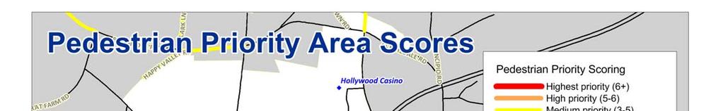


13 Map 3: Pedestrian Priority Areas Existing Conditions 11


14 12 Perryville Greenway Plan CURRENT OPPORTUNITIES REGIONAL GREENWAY ROUTES EAST COAST GREENWAY The East Coast Greenway, or ECG, is a 3000-mile traffic-free trail being developed to connect cities and towns from Calais, Maine to Key West, Florida. Linking together publicly-owned, firm-surface trails, the ECG is emerging as a safe route for exercise, recreation & transportation for the thirty million Americans who live near the route and as a tourism destination for millions of visitors. Through Cecil County, the planned route was identified in the 2003 East Coast Greenway Plan. Travelling through the most populated areas of Cecil County, the identified route connects Perryville, Charlestown, North East and Elkton before continuing to Wilmington, Delaware and Baltimore, Maryland. To date, the only section of the ECG built in Cecil County is the trail through Perryville Community Park and Perry Point, and no sections have been designated by the ECG Alliance. An interim-on-road route has been identified for travelers who wish a continuous bicycle route; cue sheets and a user guide (under development) are intended to promote use of the on-road route. Currently, the only weekend and off hour connection to Hartford County, where the trail continues southbound, is using Billers Bikes shuttle service or taxi. Bicycle racks are available on buses between Perryville and Harford County on weekdays. A water taxi is also planned to serve as an alternative river crossing. More information is available at LOWER SUSQUEHANNA HERITAGE GREENWAY The Lower Susquehanna Heritage Greenway (LSHG) is a nonprofit organization whose mission is to stimulate local economic activity by developing a linkage between our natural, historic and cultural resources. This linkage is a series of land and water recreational trails along both banks of the Susquehanna River. Currently, the greenways in the Perryville Community Park, Perry Point and paralleling Frenchtown Road are part of the LSHG network. As with the ECG, currently only Billers Bikes shuttle service and taxi connect the two sides of the river for nonmotorized use. In 2012, however Harford and Cecil counties have teamed up to being transit service across the river using buses equipped with bike racks. Plans are also under development for water taxi service. Long-term, the LSHG plans 40 miles of interconnected public recreation trails connecting Harford and Cecil Counties as detailed in the 2000 LSHG Management Plan. The Management Plan lists old town Perryville as one of four target investment zones. Information may be found at Lower Susquehanna Heritage Greenway MASON-DIXON TRAIL The Mason Dixon Trail (M-DT) links the Appalachian Trail and Brandywine Trail. This 193-mile trail starts at Whiskey Springs on the Appalachian Trail and ends in Chadds Ford, PA on the banks of the Brandywine River, passing through Pennsylvania, Maryland and Delaware. The M-DT crosses the Susquehanna River and travels through Perryville near the southernmost section of the route. Maintained primarily be volunteers, the M-DT is a walking trail that prefers unpaved, off-road facilities. Information may be found at

15 Existing Conditions 13 OTHER OPPORTUNITIES STATE LEVEL SUPPORT FOR WALKING AND BICYCLING The Maryland Department of Transportation, through the Maryland Trails Strategic Implementation Plan and Maryland Bicycle & Pedestrian Access Master Plan lays out actions that can be accomplished in coordination with the state to promote additional walking and bicycling facilities and their use. PERRYVILLE GREENWAY COMMITTEE Having an established Greenway Committee is a large advantage towards implementing this plan. A key to having a plan that does more than stay on the shelf, is having a dedicated group to monitor progress and adjust recommendations over time. WALKABLE LAND USE Most important destinations schools, the town hall, post office, shopping fall within a 20 minute, one mile walk of most residential areas, particularly south of US 40. Perryville is also blessed with natural areas, parks and historic sites that, when combined with active recreational opportunities, can attract tourism to the community.
16 Recommended Pedestrian, Bicycle and Greenway Route Network 15 RECOMMENDED PEDESTRIAN, BICYCLE AND GREENWAY ROUTE NETWORK The recommended bicycle, pedestrian and greenway network provides a comprehensive network of trails, pathways and bikeways that connect to schools, parks, community centers, the library and retail areas. The following three maps show both existing and recommended facilities. Some of the recommended facilities exist in previous planning documents including the Lower Susquehanna Heritage Greenway Management Plan and East Coast Greenway Feasibility Study, while other recommendations are presented for the first time in this document. Alignments shown are conceptual in nature and subject to adjustment, field verification and additional studies. Greenways shown are intended as all-weather transportation spines; additional single track nature trails or mountain bike trails might connect to these to increase the variety of recreational experiences offered in Perryville. Some segments show sidewalk and greenway options, for which the preferred design should be determined through additional engineering analysis. Types of facilities described as part of the routes include, with more details included in the Strategies and Actions section: PATHWAY: A multi-use bicycle and pedestrian path separated from motorized vehicular traffic by an open space, barrier or curb (Map 4). Multi-use paths may be within the highway right-of-way or within an independent right-of-way, such as on an abandoned railroad bed or along a stream valley park. Multi-use paths typically accommodate two-way travel and are open to pedestrians, bicyclists, in-line skaters, wheelchair users, joggers and other nonmotorized users. They are typically surfaced in asphalt or concrete, but may have hard-packed/all weather gravel or dirt surfaces. To safely accommodate a range of users, multi-use paths should be a minimum of 10 wide (but may be less in constrained conditions). Greenway trails and sidepaths are types of pathways. GREENWAY TRAIL: A linear park outside of roadway right-of-way which accommodates pathways principally for foot traffic and/or bicycles (Map 4). Typically, greenway trails are planned along creeks, streams, rivers or other natural features and managed as natural environments. In many cases, the term greenway refers to pathways such as the Lower Susquehanna Heritage Greenway or East Coast Greenway. SIDEPATH: A pathway within the roadway right-of-way or near the road within an easement for multi-use nonmotorized travel (Map 4). Sidepaths should be a minimum of 10 wide (but sidewalks may be substituted in constrained conditions). SIDEWALK: That portion of a highway, road or street specifically constructed for the use of pedestrians on the outside edge of the vehicular travel way (Map 5). Sidewalks are typically, but not always, curb-separated from the roadway and made of concrete, brick, asphalt or another hard surface material. Sidewalks should be a minimum width of 5 feet if set back from the curb or 6 feet if at the curb face. Five foot paved sidewalks are not always feasible due to Critical Areas and other environmental factors. MULTI-USE: Refers to multiple transportation options sharing a system or corridor (Map 4). Multi-use routes allow for travel by walking, bicycling, and other nonmotorized uses. SHARROWS OR SHARED LANE MARKING: On urban roads without sufficient width for bicycle lanes, sharrows are a pavement marking showing a bicycle with a chevron that is placed in the travel lane (Map 6). Sharrows serve to assist bicyclists with proper lane positioning relative to the curb and on-street parallel parking in lanes that are too narrow for a motor vehicle and a bicycle to travel side by side within the same traffic lane, alert road users of the lateral location bicyclists are likely to occupy within the lane, encourage safe passing of bicyclists by motorists, and reduce the incidence of wrong-way bicycling. BICYCLE LANE: A portion of a road that has been designated for preferential or exclusive use by bicyclists by pavement markings and, if used, signs (Map 6). The preferred width is 5 feet, or 6 feet when on-street parking is present. CROSSWALK: A designated point on a road at which some means are employed to assist pedestrians who wish to cross a road or intersection. They are designed to keep pedestrians together where they can be seen by motorists, and where they can cross most safely.

 pedestrian and bicycle access using transit or water taxi, (2) signing and marking bridge for bicycle travel, and/or (3) subsidizing cost of taxi/shuttle service to")


17 16 Perryville Greenway Plan KEY RECOMMENDATIONS Project or Program Susquehanna River Crossing Description The Susquehanna River is a barrier to bicycle and pedestrian travel along the East Coast Greenway and Lower Susquehanna Heritage Greenway as well as regional destinations in Harford County. A dedicated bicycle and pedestrian crossing would increase access to Cecil and Harford counties without the time-of-day and mode of travel constraints of the short-term options. Short-term options include (1) pedestrian and bicycle access using transit or water taxi, (2) signing and marking bridge for bicycle travel, and/or (3) subsidizing cost of taxi/shuttle service to make bicycle and pedestrian travel costs no more that the toll. Reconstruction of the railroad bridge over the Susquehanna offers one potential opportunity for a dedicated bicycle and pedestrian crossing. Planning for a reconstructed railroad bridge should examine the feasibility of providing a pedestrian and bicycle facility adjacent to freight or commuter rail tracks that is safe, provides adequate separation and addresses security concerns. Trailheads can serve to support those crossing the Susquehanna. Trailhead facilities after the Hatem Bridge and near the pier can have bicycle/pedestrian route information, parking, and transfer facility for other travel modes. Enhanced Bridge marking options: The graphic on the right shows the use of sharrows and signs to indicate that the bridge is shared with bicycle traffic. On the left, bicyclists push a button, similar to a crosswalk button, to trigger flashing lights on the bridge. Wayfinding/signing program Pedestrian and bicycle scale directional signing to key destinations will promote walking and bicycling by residents and visitors. The example to the right, provided in the NACTO Urban Bikeway Design Guide, shows direction of locations of interest to pedestrians and bicycles, distance and estimated travel time by bicycle. Additional walk/bike directional signs should complement the existing driver wayfinding sign at the intersection of Broad and Aiken as pedestrians will arrive from other areas including the train station and town pier. Wayfinding to greenways is important as some trailheads, such as the greenway south of the Amtrak rail, are not easy to find for those unfamiliar with them. Additional signing can be oriented towards fitness users by marking distances along greenways and loop walking and bicycle routes for exercise.
18 Recommended Pedestrian, Bicycle and Greenway Route Network 17 KEY RECOMMENDATIONS Project or Program Description Safe Routes to Establish a Safe Routes to School (SRTS) program to bring together parents, school administrators, School teachers, and other community groups and agencies, to improve the safety of children who walk or bicycle to school. The program enables and encourages children in grades K-8 to walk and bicycle to school. Through the promotion of walking, Safe Routes to School also bolsters child health by encouraging physical activity and enhances the environment by reducing traffic, fuel consumption and air pollution near elementary and middle schools. WILMAPCO can provide planning assistance to interested schools. Participants in a SRTS program are eligible for federal funding for implementing associated programs and physical improvements. Complete Streets Policy Greenway Committee Regional Greenway Network Complete Streets are streets for designed and operated to enable safe access for all users. Pedestrians, bicyclists, motorists, emergency vehicles and transit riders of all ages and abilities must be able to safely move along and across a complete street. Complete Streets make it easy to cross the street, walk to shops, and bicycle to work. They allow buses to run on time and make it safe for people to walk to and from train stations. According the the National Complete Streets Coalition, an ideal complete streets policy: Includes a vision for how and why the community wants to complete its streets Specifies that all users includes pedestrians, bicyclists and transit passengers of all ages and abilities, as well as trucks, buses and automobiles. Applies to both new and retrofit projects, including design, planning, maintenance, and operations, for the entire right of way. Makes any exceptions specific and sets a clear procedure that requires high-level approval of exceptions. Encourages street connectivity and aims to create a comprehensive, integrated, connected network for all modes. Is adoptable by all agencies to cover all roads. Directs the use of the latest and best design criteria and guidelines while recognizing the need for flexibility in balancing user needs. Directs that complete streets solutions will complement the context of the community. Establishes performance standards with measurable outcomes. Includes specific next steps for implementation of the policy The existing Greenway Committee should continue to work towards implementing the Plan, monitoring its effectiveness and modifying its recommendations as needed. Committee membership should be expanded to include additional state and local partners who can assist with the Plan implementation. The Lower Susquehanna Heritage Greenway and East Coast Greenway provide important regional and interregional connections. Continue to work with these organizations to develop the routes and then market their use.

19 18 Perryville Greenway Plan Map 4: Recommended Greenways
20 Recommended Pedestrian, Bicycle and Greenway Route Network 19 ID Project Road From - To Description Length Lead Greenway G1 Casino to Outlets MD 222 Turnpike Dr. - Heather Sidepath connecting Hollywood Casino and Perryville Outlets. An 0.56 MD SHA Connector Ln. alternative would be sidewalks and bicycle lane. G2 Perryville High Cedar Corner Rd. - Greenway connects sidewalks in planned Cedar Corner subdivision 0.35 Perryville School Connector Ingleside Ave. to existing greenway around high school G3 Woodlands Greenway within the planned Woodlands subdivision connecting residential to transit center, commercial areas, parkland and library. approx 1.8 Town Point Development G4 Woodlands US 40 Couden Blvd. - Sidepath extends Woodlands planned route further along US 40 to 2.6 MD SHA Connector Woodlands property Couden Blvd, connecting to additional Woodlands greenway here. G5 Schools and Library Connector G6 G7 G8 G9 G10 G11 G12 G13 G14 MD 7, East Coast Greenway Ikea Way, East Coast Greenway Marion N. Tapp Parkway, East Coast Greenway Avenue A, East Coast Greenway Town Hall Connector Franklin to John Connector Frankin-LSHG Connector Lower Susquehanna Heritage Greenway Lower Susquehanna Heritage Greenway MD 7 Principio Station Rd. - Ikea Way Ikea Way MD 7 - Marion N. Tapp Parkway Marion N. Tapp Ikea Way - Avenue A Parkway Greenway connects Perryville Elementary School, Good Shepherd Catholic School, Perryville Middle School and the Perryville Library, through Cecil County Board of Education Property. Planned East Coast Greenway route into Perryville is proposed as a sidepath parallel to MD 7. Planned Lower Susquehanna Heritage Greenway and East Coast Greenway. Sidepath connecting to park access road. Planned Lower Susquehanna Heritage Greenway and East Coast Greenway. Greenway paralleling park access road Perryville, Cecil County Board of Education 1.64 MD SHA 0.36 Perryville 1.96 Perryville Avenue A Marion N. Tapp - Frenchtown Rd Planned Lower Susquehanna Heritage Greenway and East Coast Greenway. Greenway parallel to Avenue A LSHG/VA Honaker St. - Otsego Greenway along public right of way connecting to Town Hall. 0.2 Perryville St. Franklin St. - John St. Greenway along public right of way providing connection through 0.06 Perryville neighborhood. Franklin St. - Rustic Greenway along utility line connecting neighborhood to Lower 0.12 Perryville Court Susquehanna Heritage Greenway. Would require coordination with utility and an at grade crossing of Norfolk Southern Delmarva Secondary Track. Frenchtown Rd. LSHG gap in greenway near NS railroad overpass LSHG Frenchtown Rd. N. of Rustic Court - Perryville Line Continuation of LSHG north of existing sections LSHG
21 20 Perryville Greenway Plan Map 5: Recommended Sidewalks
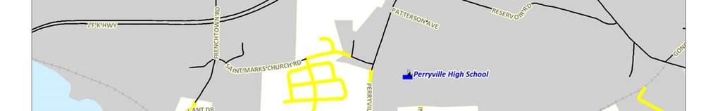
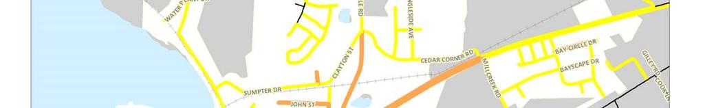
22 Recommended Pedestrian, Bicycle and Greenway Route Network 21 ID Project Road From - To Description Length Lead Sidewalk S1 MD 222 MD 222 Turnpike Dr. - Heather Ln. S2 MD 222 MD 222 Heather Ln. - Cedar Corner Rd. S3 St. Marks Church St. Marks MD Beacon Rd. Church Rd. Point Dr./Penny Ln. S4 Sumpter Dr./Clayton St. Sumpter Dr./Clayton St. S5 Cedar Corner Rd. Cedar Corner Rd. S6 Cedar Corner Rd. development Frenchtown Rd. - MD 222 S7 MD 222 MD 222 Cedar Corner Rd. - US 40 S8 US 40 US 40 East Perryville boundary - MD 222 Construct sidewalk on west side of road if recommended greenway (G1) is not feasible MD SHA Pedestrian Priority Area 3 Construct sidewalk on both sides of road MD SHA Medium Construct sidewalk to Beacon Point Drive on south side and to Penny Lane on north side. Sidewalk should extend further west if development occurs Cecil County Construct sidewalk on at least one side of the road Perryville Medium MD US 40 Construct sidewalk on north side of the road at minimum Perryville Medium Construct sidewalk within planned development off of Cedar Corner Rd. 0.8 Developer Medium Construct sidewalk on east side of the road MD SHA High Construct missing sidewalk on both sides of road MD SHA High S9 Coudon Blvd. Coudon Blvd. US 40 - Broad St. Construct sidewalk on west side of road if recommended greenway (G3) is not feasible. SHA would consider Coudon Blvd./US 40 crosswalk upon implementation of S9. S10 Broad Street Broad Street Coudon Blvd. - Ikea Way S11 Broad Street Broad Street Ikea Way - existing sidewalk S12 Broad Street Broad Street Roundhouse Dr. - existing sidewalk 0.54 Perryville/ Cecil Co. Construct sidewalk on north side of the road at minimum MD SHA High Highest Construct sidewalk on both sides of road MD SHA/ High Developer Construct missing sidewalk on south side of road MD SHA Highest S13 Otsego Street Otsego Street Evans Street - Construct missing sidewalk on north side of road Perryville Highest existing sidewalk S14 Ikea Way Broad Street Park entrance Construct sidewalk to provide access to the park 0.5 Perryville Medium 3 WILMAPCO 2011 Pedestrian Priority Area scoring adjusted for Perryville. Scores may not reflect town priorities or opportunities to combine pedestrian facilities with other transportation or development projects.

23 22 Perryville Greenway Plan Map 6: Recommended Bicycle Routes
24 Recommended Pedestrian, Bicycle and Greenway Route Network 23 ID Project Road From - To Description Length Lead Bicycle B1 Bainbridge Rd. Bainbridge Rd. Port Deposit - MD 222 Restripe road to provide bicycle lane. 2.5 MD SHA B2 MD 222 MD 222 Bainbridge Rd. - Restripe road to provide bicycle lane. Limits might be reduced if 0.85 MD SHA Blythedale Rd. Greenway G1 is constructed. B3 Blythedale Rd. Blythedale Rd. Bainbridge Rd. - MD Restripe road to provide bicycle lane MD SHA 222 B4 MD 222 MD 222 Blythedale Rd. - US 40 Restripe road to provide bicycle lane MD SHA B5 US 40 US 40 Winch Rd. - Hatem Bridge Mark shoulder as bicycle lane. Remark intersections to include bike facilities through turn lanes 2.51 MD SHA B6 Principio Furnace Rd. Principio Furnace Rd. Cook Ln. - Coudon Blvd. Mark with shared lane markings or narrow lanes to include bike lane. Might be eliminated if Greenway G6 is implemented MD SHA B7 Broad Street Broad Street Coudon Blvd. - Ikea Way B8 Ikea Way Ikea Way Broad St. - Marion N. Tapp Park. B9 Marion N. Tapp Parkway Marion N. Tapp Parkway Ikea Way - Avenue A Restripe to provide bike lanes. Might be eliminated if Greenway G6 is implemented. Mark with shared lane markings. Might be eliminated if Greenway G7 is implemented. Mark with shared lane markings. Might be eliminated if Greenway G8 is implemented. B10 Avenue A Avenue A Avenue A - Front St. Restripe to provide bike lanes. Might be eliminated if Greenway G9 is implemented. B11 Broad Street Broad Street Front St. - Ikea Way Mark with shared lane markings. Space might exist to combine shared lane markings on one side with a bicycle lane on the other 0.24 MD SHA 0.35 Perryville 1.86 Perryville 0.33 Perryville 0.69 MD SHA B12 Aiken Avenue Aiken Ave. Broad St. -US 40 Mark with shared lane markings MD SHA B13 Franklin St. Franklin St. MD end Mark with shared lane markings Perryville B14 Hatem Bridge US 40 Coordinate with Maryland DOT and MDTA to determine preferred option for bicycle access. 1.3 MDTA SHA will require further study to assess the feasibility of B1, B2, B3, B5, B6, B7 and B11. SHA shares the Plan goal to increase bicycle facilities on SHA maintained roads and is working to take advantage of available road width when roads are resurfaced by restriping with bicycle facilities.


25 Strategies and Actions 25 STRATEGIES AND ACTIONS DEVELOP A COORDINATED NETWORK THAT IS SAFE, ACCESSIBLE, CONVENIENT AND PROVIDES INTERMODAL CONNECTIONS INCREASE THE USE OF WALKING AND BICYCLING FOR TRANSPORTATION A Complete Streets Policy is a key approach towards providing facilities along important transportation corridors. Complete Streets are streets designed and operated to enable safe access for all users. Pedestrians, bicyclists, motorists and transit riders of all ages and abilities must be able to safely move along and across a complete street. Complete Streets make it easy to cross the street, walk to shops, and bicycle to work. They allow buses to run on time and make it safe for people to walk to and from train stations. A Complete Streets Policy directs Perryville, working with Maryland State Highway Administration and Maryland Department of Transportation, to routinely design and operate the entire right of way to enable safe access for all users, regardless of age, ability, or mode of transportation along both state and locally maintained roads. Every transportation project should make the street network better and safer for drivers, transit users, pedestrians, and bicyclists where feasible. This approach provides transportation by walking and bicycling to the destinations served by existing roads. The National Complete Streets Coalition has additional guidance at EXPAND BICYCLE, PEDESTRIAN AND GREENWAY ACCESSIBILITY AND CONNECTIVITY Bordered by the Susquehanna River and Chesapeake Bay, and bisected by I-95 and Amtrak, Norfolk Southern and CSX rail lines, Perryville s geography limits its connections within the town and to surrounding areas. Rail and utility corridors offer potential alignments for greenways with minimal road crossings. The recommended Bicycle, Pedestrian and Greenway Route Network, described earlier in this plan, includes projects which provide new connections for bicycle and pedestrian access. Priority connections include working with MDOT and MDTA to provide access across the Susquehanna River and coordinating with SHA on connections along and across MD 222 and US 40. Other priority projects include completion of the Lower Susquehanna Heritage Greenway and East Coast Greenway. The proposed network should be incorporated into future Comprehensive Plan updates. The town should seek funding for identified priority gap projects; suggested funding sources are included in the Funding, Implementation and Evaluation section of the plan. The bridge at Harpers Ferry is an example of a combined rail and pedestrian bridge Planning for Safe Routes to Schools is an important component of access and connectivity. In 1969, about half of all students walked or bicycled to school nationwide, while today fewer than 15 percent of all school trips are made by walking or bicycling, one-quarter are made on a school bus, and over half of all children arrive at school in private automobiles. This decline in walking and bicycling has had an adverse effect on traffic congestion and air quality around schools, as well as pedestrian and bicycle safety. In addition, a growing body of evidence has shown that children who lead sedentary lifestyles are at risk for a variety of health problems such as obesity, diabetes, and cardiovascular disease. Safety issues are a big concern for parents, who consistently cite traffic danger as a reason why their children are unable to bicycle or walk to school. The Safe Routes to School Program (SRTS), at both the state and federal levels, seeks to promote safe walking and bicycling around schools by funding infrastructure improvements (sidewalks, crosswalks, pedestrian signals/signage, school zone signage) as well as a variety of outreach, education and promotional programs.

26 26 Perryville Greenway Plan FOSTER INTERMODAL LINKAGES AND AMENITIES TO SUPPORT TRIPS BY WALKING AND CYCLING Ensuring a strong bicycle and pedestrian link to transit is important for the success of transit service in Perryville. The integration of walking and bicycling facilities with public transit facilities and services allows users to reach transit stops and destinations; indeed, most transit riders are pedestrians at either one or both ends of the trip. Four primary components of bicycle and pedestrian integration with transit include: Allowing bicycles on transit. Cecil County is working towards installing bicycle racks on all buses, allowing longer trips to combine bicycling and transit. These racks will equip buses to carry two bikes on the front of the bus. MARC's current bicycle policy allows for the transportation of folding bicycles only and the existing fleet offers no designated storage areas for bikes. Offering benches, shelters, schedule information and bicycle parking at transit. Bus ridership benefits from having information about the routes and facilities to make riders comfortable at bus stops. Currently Perryville has some of these amenities at bus stops, but Perryville should work with Cecil County transit to monitor ridership and provide amenities at the better performing stops as warranted. Currently the MARC station has a bicycle rack, but this rack should be upgraded to a preferred design and supplemented with bicycle lockers or secure parking for longer-term storage. The transit center planned for the Woodlands development is a good example of this integration and includes bicycle racks and lockers. Improving connections to transit. Priority projects for implementation include improved and additional crosswalks near transit stops and the train station, as well as additional sidewalks to bus stops. As most transit riders will need to cross the street for the return trip, safe crosswalks are particularly important. At the train station, a crosswalk between overflow parking at the Methodist Church and pedestrian facilities within the parking lot should be added. Perryville should continue to explore the potential bicycle and pedestrian access via a water taxi. In additional to providing a transportation to Havre de Grace and Port Deposit, the water taxi itself, has the potential to attract active recreation tourism to the area when combined with connecting bicycle and pedestrian pathways. PROVIDE END OF TRIP FACILITIES FOR BICYCLISTS AND GREENWAY USERS Adequate and secure bicycle parking should be provided at all major trip destinations to encourage travel by bike. Bicycle parking should be provided as part of multi-family residential developments and all commercial, industrial and institutional developments and park-and-ride lots. Perryville s zoning code does currently require parking for commercial and mixed-use development but ARTICLE XVI PARKING does not give specific detail for meeting the requirement; provides links to suggested zoning code. The zoning code should be updated to: Specify number of bicycle spaces by land use. For all workplaces, transit stations and multi-unit residential, this should include secure long-term parking such as bicycle lockers or indoor parking. Other land uses should require adequate short-term parking. Provide site planning requirements. Bicycle parking should be located as close as possible to building entrances. Where this is not possible, signs should direct cyclists to the location of bicycle parking, especially if the rack is not visible from the entrance or street. Ideally, rack should be located in a covered area. Provide rack and locker design requirements; suggested designs are described in detail at Inadequate racks put bikes at risk of theft because they can t be properly locked and may damage bikes by bending the wheels. Racks should: support the frame of the bicycle, not just one wheel allow the frame and one wheel to be locked to the rack when both wheels are left on the bike and both wheels to be locked if the front wheel is removed allow the use of either a cable or U-shaped lock be securely anchored be usable by a wide variety of sizes and types of bicycles including those with no kickstand and bikes with water bottle cages Old-fashioned schoolyard racks do not provide secure parking for modern style bikes. Bikes shown here have wider tires and are unable to use rack as designed.
27 Strategies and Actions 27 In addition to bicycle racks, provision of showers and changing areas at worksites will encourage commute trips using bicycle routes and greenways. Source: Association of Bicycle/Pedestrian Professionals
28 28 Perryville Greenway Plan USE BEST PRACTICES FOR ENGINEERING SAFE TRAIL, SIDEWALK AND BICYCLE FACILITIES Perryville and SHA should draw upon existing design standards to design new facilities and improve those that fall short of modern standards, most notably the SHA Accessibility Policy & Guidelines for Pedestrian Facilities along State Highways and SHA Pedestrian and Bicycle Design Guidelines. In addition, existing guidance can be found in the Architectural and Transportation Barriers Compliance Board (Access Board), AASHTO Guide for the Planning, Design, and Operation of Bicycle Facilities (update currently draft), and Manual on Uniform Traffic Control Devices (MUTCD). The NACTO Urban Bikeway Design Guide, while not accepted design by Maryland DOT, is used to design bicycle facilities in Baltimore and other urban locations around the country. Links to design resources can be found at In addition, MD SHA has developed design guidelines for the preferred accommodations to benefit bicycling and walking along State highways and SHA Pedestrian and Bicycle Design Guidelines. It is SHA s goal to provide the preferred accommodations as part of all roadway projects where feasible and reasonable. Providing bicycle and pedestrian accommodations is especially important where the existing or proposed land use supports cycling and walking. This includes trip generators and destinations such as employment, education, residential, commercial, recreation, and transit centers. A short summary of preferred route design is as follows: Perryville Pedestrian, Bicycle and Greenway Route Types Design Type Width Surface Primary User Treatment Function Sidewalk 5-16 ft Concrete, brick Pedestrian Located along streets, preferably separated by curb, planting strip, parking lane, etc. Provides access to homes, businesses and local destinations for pedestrians and wheelchair users. Bicycle lane 4-6 ft Asphalt Bicyclist Striped lane for bike travel on road. Bicycle travel along roads. Sharrow/Shared Street NA NA Bicyclist Share lane marking and/or signage for shared use of lane Accommodates bicyclist on lower volume roads or roads without sufficient width for bicycle lanes. Pathway, Sidepath or Greenway ft Asphalt, concrete, stone dust Pedestrian and bicyclist Provides a route completely separated from motor vehicles and shared by bicycles and pedestrians. Provides linear park space and desirable, traffic-free connections to key destinations. May parallel roads where traffic speeds or limited right-of-way make providing sidewalks and bicycle lanes infeasible or undesirable. Trail Less than 10 ft Earth or stone dust Pedestrian and mountain bike Provides a primarily recreational route that should connect with larger bicycle and pedestrian network. Provides more natural trail for recreational use.


29 Strategies and Actions 29 SIDEWALKS Sidewalks provide the most fundamental element of the walking network in a town setting, and in a smart growth community, the end of the sidewalk typically signals the boundary between town and country. Main elements include the curb and buffer, which separate the sidewalk from vehicular traffic and the sidewalk itself. The buffer can also include on street parking or a bike lane. Street trees make attractive buffers but care should be taken to select trees whose roots will have minimum impact of the sidewalk. The pedestrian zone should be free of obstructions such as utility poles but can wind around trees and poles. The minimum five-foot width enables uses by two people walking side-by-side, passing other users, and wheel chair users. Concrete sidewalks offer smooth surfaces and long lifespans, but brick or asphalt may also be used. In addition, the shy zone provides separation between pedestrians and adjacent land use; this shy zone can be wider to accommodate window shopping, benches, or outdoor dining. The SHA Pedestrian and Bicycle Design Guidelines include desired minimum widths for these elements, shown on the next page. Sidewalks ideally are installed as part of individual development projects because retrofitting sidewalks can be difficult and costly for several reasons. New sidewalks typically require drainage improvements such as undergrounding roadside culverts and installation of curb and gutter. Obtaining needed right-of-way presents another challenge and even when sufficient width exists the adjacent property owners may object if they see the public land as part of their front yard. Building gaps in sidewalks however is important to creating a continuous pedestrian routes and can save the community over time by reducing personal transportation expenses and reducing the need for school bussing. Driveways present another challenge for building sidewalks. Sidewalks that remain level are preferred to sidewalks that dip down at each driveway. Sidewalks that slope with the driveway may not meet ADA guidelines if the grade of the slope is more than 2%. The sidewalk can wrap around the driveway ramp if needed to remain level, however this presents a challenge for those who have visual impairments. The photos 4 below show example driveway designs. Example of level sidewalk with driveway apron using the planting strip Example of sidewalk wrapped around driveway It is also desirable to use access management between adjacent land uses to reduce the number of curb cuts interrupting sidewalks. This includes shared driveways between properties and pedestrian connections from one development to the next. 4 Photo source: Dan Burden
30 30 Perryville Greenway Plan Source: SHA Pedestrian and Bicycle Design Guidelines


31 Strategies and Actions 31 BICYCLE LANES A Bicycle Lane is a dedicated travel lane for bicycles that is separated from vehicle travel lanes with striping and pavement stencils. Properly designed bicycle lanes can increase safety and promote proper riding. They define the road space for all users and discourage cyclists from riding on the sidewalk. Bicycle lanes are most appropriate on arterial and collector streets where the higher speeds and traffic volumes warrant greater separation for the safety and comfort of bicyclists. Depending on the speed and volume of traffic, the SHA Pedestrian and Bicycle Design Guidelines, shown on the next page, recommend a minimum of 4-6 feet in width for bike lanes. Additional width is needed where there is on-street parking so that cyclists can avoid car doors. A maximum width of 7 feet is preferred because wider bike lanes may get blocked by delivery vehicles, turning cars, etc. Parking spaces can also have a marked buffer zone to indicate the door zone to cyclists as shown in the image on the right. Where additional width exists or vehicle/bicycle conflicts are a concern, some Bicycle lane with marked door zone communities have begun using buffered bicycle lanes and colored bicycle lanes. Buffered bike lanes are conventional bicycle lanes paired with a designated buffer space separating the bicycle lane from the adjacent motor vehicle travel lane and/or parking lane. Buffered lanes provides greater shy distance between motor vehicles and cyclists, allow bicyclists to pass one another without encroaching into the motor vehicle travel lane, and provide greater space for bicycling without making the bike lane appear so wide that it might be mistaken for a travel lane or a parking lane. Green coloring may be used to highlight bike lane at conflict points with cars, such as driveways. Color draws attention to the bike lane but may quickly wear off in high traffic areas. As with retrofitting sidewalks, retrofitting bicycle lanes onto existing streets Buffered bicycle lane presents challenges. The recommended bicycle lanes should be incorporated into land use development projects or transportation projects when these occur. To reduce expense, retrofitting bicycle lanes is least expensive when done at the same time as roadway resurfacing and restriping. Retrofitting bicycle lanes may be achieved with: Remarking shoulders as bicycle lanes. This presents the easiest conversion because sufficient width is in place. Special care must be taken to redesign facilities at intersections and where shoulders are eliminated due to turning lanes. Narrowing the width of motor vehicle lanes. Many existing roads are far wider than standards suggest and striped motor vehicle lanes can be narrowed to allow for bike lanes. Road design standards allow 11 foot motor vehicle lanes in most town settings and in some cases 10 foot lanes are sufficient. Parking reduction or narrowing. While an 8 foot parking lane is desirable, a 7 foot parking lane will accommodate most vehicles and when combined with lane narrowing, provides space for bike lanes. Due to the high demand for parking in Perryville, this plan does not recommend eliminating on street parking. Widening the road to add bicycle lanes. This option can be quite costly and is only recommended on high volume roads without width to mark bike lanes.


32 32 Perryville Greenway Plan Source: SHA Pedestrian and Bicycle Design Guidelines

33 Strategies and Actions 33 SHARROW/SHARED STREET According to the SHA Pedestrian and Bicycle Design Guidelines, in Maryland, shared roadways include all roadways EXCEPT those with posted speed limits greater than 50 mph and no shoulder, and controlled access freeways. In a town setting, streets with higher traffic benefit from shared lane markings, also known as sharrows, when there is not sufficient width for bicycle lanes. Sharrows are pavement markings that help position bicyclist within the travel lane and alert motorist to the presence of bicycle traffic. Along streets without on-street parking, sharrows should be 4 feet from the curb or edge of street; with on-street parking present, sharrows should be at least 11 feet from the curb or at least 2.5 feet from the edge of the parking lane. This shows cyclist the correct position to ride to avoid car doors. Perryville and SHA may wish to position sharrows near the center of the lane; placing markings between vehicle tire tracks will increase the life of the markings. Sharrow or shared lane marking Source: SHA Pedestrian and Bicycle Design Guidelines

34 34 Perryville Greenway Plan PATHWAYS, GREENWAYS AND TRAILS Pathways provide a community far more than just a means of transportation. A pathway is a route shared by pedestrians, bicycles, wheel chair users and often other nonmotorized users including equestrians. They provide direct links between destinations with fewer road crossings than sidewalks and bike lanes. Children and novice bicyclists find pathways a safe place to learn to ride and people of all ages find them a convenient place to recreate. For many communities, pathways generate tremendous community pride for residents and draw visitors from the surrounding region. To safely serve both bicycles and pedestrians, pathways should provide addition width over a standard sidewalk. Pathways may be sidepaths build adjacent to roads or greenways through parks or open space. Sidepaths should be a minimum of 10 feet wide to allow two-way shared use with 12 feet recommended for as the minimum for most facilities. Where there are space constraints, the path may narrow to 8 feet but should be accompanied by signs warning that the trail narrows. Sufficient clearance along the sides and overhead is needed with a minimum of 2 feet on each side and 10 foot clear zone overhead. Additional elements can enhance a pathway s design including: Frequent access points with directional signs on how to reach the path. Paths that are built away from the road may be hard for potential users to find without directional signs. Build path to a standard that will allow heavy maintenance equipment and emergency vehicles. This higher upfront cost will result in a longer lasting path with lower maintenance expense. Limit the number of road crossings. The joy of using a pathway is having a direct route away from interaction with vehicle traffic. Identify and address potential safety issues. If a pathway is likely to be used for commuting and shopping trips, lighting is needed for year round use. Paths in more remote location may benefit from having emergency blue light phones. Consider the sight distances for bicycles. Sharp turns or heavy vegetation may limit faster moving cyclists from seeing oncoming bikes or pedestrians. For sidepaths, a 5 foot buffer between the road is desirable or a physical barrier should be considered. Asphalt is the most common surface however concrete or stone dust surface are alternatives. Intersections with roads need careful design and are discussed in more detail on the next page. Provide amenities for pathway users. Amenities include trail heads, public art, maps, interpretive kiosks, water fountains, bike parking, benches, restrooms, and other features to make the facility unique to Perryville.

35 Strategies and Actions 35 INTERSECTION DESIGN Intersection design is a critical part of planning for safe pedestrian and bicycle travel. Crosswalks must be conveniently located as pedestrians are not willing to travel very far out of the way to get to a designated crossing or cross multiple legs or traffic when not all sides of the intersection have crosswalks. Within mixed-use streets and high pedestrian areas, crosswalks should be provided between feet apart. Intersections should: Have good visibility for motorists. At signalized intersections, all crosswalks should be marked. Parallel line markings are not desirable because lines are hard for drivers to see and may be confused with the stop bar. Instead, ladder or piano key marking offer much better visibility. Meet modern crosswalk standards. Crosswalks should have clear space at corners with room for curb ramps. ADA curb ramps have textured/colored surface for those with limited sight. Ramps should be designed to accommodate wheel chairs, baby strollers, and those who may have mobility limitations that limit ability to step up onto a curb. Pedestrian signal heads now are required to give clear instruction with count down time shown so pedestrians can judge how much time they have to cross. Dash lines across the crosswalk Midblock or unsignalized crossings may warrant additional measures to increase driver compliance and pedestrian visibility. MAINTAIN EXISTING TRAILS Ongoing maintenance of existing facilities is needed so that they remain safe and comfortable for pedestrians and bicyclists and to reduce Perryville and MDOT s exposure to liability claims. Along on-road facilities, potholes and debris can lead to cyclists swerving toward traffic while buckled or cracked sidewalks may prevent their use by persons with disabilities. Maintenance should be addressed through three processes: 1. Maintenance of sidewalks and on-road bicycle routes should be completed in conjunction with roadway paving and rehabilitation projects. Scope of work for roadway preservation should account for needed bike lane paving and striping, sidewalks, crosswalks and curb ramps. Any paving project should upgrade curb ramps to be ADA accessible and add pedestrian countdown signals. Future maintenance and operations should be incorporated into the planning and design of all transportation projects. Public works and emergency response personnel should be involved in project design to ensure the consideration of maintenance and operations issues that impact these agencies. Each new project should establish a management and operations plan during the initial planning which accounts for who will complete each maintenance and operations task and how they will be funded. 2. Establish a schedule for routine maintenance activities. Details about recommended maintenance activities are show in the Funding, Implementation and Evaluation section of this plan. Funding for ongoing operations and maintenance should be including in the Town s annual budget. Many routine activities can be supported by an Adopt-a-Greenway program. Scouting troops and other community service organizations can also support routine maintenance and operations. For example a Trail Stewards program can train volunteers hit the trail to become ambassadors and provide eyes-and-on the greenway. Trail Stewards can assist trail users with directions and advice, promote use of the trail and report on trail conditions, visitor needs and safety concerns. 3. Establish a program for facility users to report maintenance issues. Publicizing phone contacts for bike lane, greenway and sidewalk issues is important. Phone-in reporting can be supplemented by using a web site such a This web site offers free service that allows users to report issues directly onto a map using a computer or smart phone. Perryville then
Perryville TOD and Greenway Plan
 Perryville TOD and Greenway Plan Greenway Glossary Pathway: A bicycle and pedestrian path separated from motorized vehicular traffic by an open space, barrier or curb. Multi-use paths may be within the
Proposed. City of Grand Junction Complete Streets Policy. Exhibit 10
 Proposed City of Grand Junction Complete Streets Policy Exhibit 10 1 City of Grand Junction Complete Streets Policy Vision: The Complete Streets Vision is to develop a safe, efficient, and reliable travel
City of Novi Non-Motorized Master Plan 2011 Executive Summary
 City of Novi Non-Motorized Master Plan 2011 Executive Summary Prepared by: February 28, 2011 Why Plan? Encouraging healthy, active lifestyles through pathway and sidewalk connectivity has been a focus
Perryville Transit Oriented Development & Greenway Plan
 A Partnership of the Town of Perryville and WILMAPCO Perryville Transit Oriented Development & Greenway Plan Why plan for TOD and Greenways? Identify strategies to enhance community character in Perryville
ACTIVE TRANSPORTATION
 ACTIVE TRANSPORTATION Mobility 2040 Supported Goals Improve the availability of transportation options for people and goods. Support travel efficiency measures and system enhancements targeted at congestion
NM-POLICY 1: Improve service levels, participation, and options for non-motorized transportation modes throughout the County.
 Transportation PRINCE WILLIAM COUNTY 2008 COMPREHENSIVE PLAN NON-MOTORIZED PLAN CONTENTS Goals, Policies, and Action Strategies Table 4 (Bike Facility Classifications and Descriptions) Table 5 (Bike Facility
CITY OF BLOOMINGTON COMPLETE STREETS POLICY
 CITY OF BLOOMINGTON COMPLETE STREETS POLICY POLICY OBJECTIVE: The City of Bloomington will enhance safety, mobility, accessibility and convenience for transportation network users of all ages and abilities,
Solana Beach Comprehensive Active Transportation Strategy (CATS)
") Solana Beach Comprehensive Active Transportation Strategy (CATS) 3.0 Goals & Policies The Solana Beach CATS goals and objectives outlined below were largely drawn from the Solana Beach Circulation Element
Solana Beach Comprehensive Active Transportation Strategy (CATS) 3.0 Goals & Policies The Solana Beach CATS goals and objectives outlined below were largely drawn from the Solana Beach Circulation Element
Chapter 2. Bellingham Bicycle Master Plan Chapter 2: Policies and Actions
 Chapter 2 Bellingham Bicycle Master Plan Chapter 2: Policies and Actions Chapter 2: Policies and Actions The Bicycle Master Plan provides a road map for making bicycling in Bellingham a viable transportation
INDOT Complete Streets Guideline & Policy
 INDOT Complete Streets Guideline & Policy INTRODUCTION The Complete Streets guidelines build upon multiple efforts and promote a multimodal transportation system that is integrated and sustains land use
DRAFT MOVING FORWARD RHODE ISLAND BICYCLE MOBILITY PLAN 2018 PREPARED FOR PREPARED BY IN ASSOCIATION WITH
 RHODE ISLAND MOVING FORWARD BICYCLE MOBILITY PLAN 2018 PREPARED FOR PREPARED BY IN ASSOCIATION WITH T AF CHAPTER 1 D R INTRODUCTION CHAPTER 3 ARTICULATES VISION Bicycling is safe, fun and practical in
Corpus Christi Metropolitan Transportation Plan Fiscal Year Introduction:
 Introduction: The Safe, Accountable, Flexible, Efficient Transportation Equity Act: A Legacy for Users (SAFETEA-LU) has continued the efforts started through the Intermodal Surface Transportation Efficiency
Bikeway action plan. Bicycle Friendly Community Workshop March 5, 2007 Rochester, MN
 Bikeway action plan Summary The was held on March 5, 2007 at the Rochester Mayo Civic Center. The workshop was hosted by Rochester-Olmsted County Planning Department in collaboration with the League of
Non-Motorized Transportation 7-1
 Non-Motorized Transportation 7-1 Transportation facilities no longer mean just accommodating a vehicle powered by a combustion engine. Pedestrian and non-motorized facilities are important modes of travel
CITY OF COCOA BEACH 2025 COMPREHENSIVE PLAN. Section VIII Mobility Element Goals, Objectives, and Policies
 CITY OF COCOA BEACH 2025 COMPREHENSIVE PLAN Section VIII Mobility Element Goals, Objectives, and Policies Adopted August 6, 2015 by Ordinance No. 1591 VIII MOBILITY ELEMENT Table of Contents Page Number
Transportation Master Plan Advisory Task Force
 Transportation Master Plan Advisory Task Force Network Alternatives & Phasing Strategy February 2016 BACKGROUND Table of Contents BACKGROUND Purpose & Introduction 2 Linking the TMP to Key Council Approved
Living Streets Policy
 Living Streets Policy Introduction Living streets balance the needs of motorists, bicyclists, pedestrians and transit riders in ways that promote safety and convenience, enhance community identity, create
Cecil County, Maryland. Bicycle Master Plan
 Cecil County, Maryland Bicycle Master Plan Overview Background Schedule and Tasks Network Assessment Network Identification Next Steps Schedule and Tasks May 2011 Plan Scoping and Mobilization Data Collection
Chapter 5 Future Transportation
 Chapter 5 Future Transportation The Future Land Use Plan identifies the desired land use designations. The land uses desired for Crozet depend, in large part, on the success of the transportation system,
ACTIVE TRANSPORTATION/NONMOTORIZED TRANSPORTATION
 ACTIVE TRANSPORTATION/NONMOTORIZED TRANSPORTATION BACKGROUND Active transportation, also known as nonmotorized transportation, is increasingly recognized as an important consideration when planning and
PEDESTRIAN ACTION PLAN
 ATTACHMENT 2 CITY OF SANTA MONICA PEDESTRIAN ACTION PLAN CITY OF SANTA MONICA PEDESTRIAN ACTION PLAN This page intentionally left blank EXECUTIVE SUMMARY CHAPTER 1 EXECUTIVE SUMMARY Setting the Stage
Agenda. Overview PRINCE GEORGE S PLAZA METRO AREA PEDESTRIAN PLAN
 PRINCE GEORGE S PLAZA METRO AREA PEDESTRIAN PLAN May 28, 2008 Agenda Welcome and introductions Project overview and issue identification Planning context and strengths Design challenges and initial recommendations
CONNECTING PEOPLE TO PLACES
 CONNECTING PEOPLE TO PLACES 82 EAST BENCH MASTER PLAN 07 Introduction The East Bench transportation system is a collection of slow moving, treelined residential streets and major arteries that are the
Section 9. Implementation
 Section 9. Implementation The transportation system is just one of many aspects that must be carefully planned to maintain and enhance the quality of living in Cecil County. The Cecil County Bicycle Plan
Exhibit 1 PLANNING COMMISSION AGENDA ITEM
 Exhibit 1 PLANNING COMMISSION AGENDA ITEM Project Name: Grand Junction Circulation Plan Grand Junction Complete Streets Policy Applicant: City of Grand Junction Representative: David Thornton Address:
Chapter 14 PARLIER RELATIONSHIP TO CITY PLANS AND POLICIES. Recommendations to Improve Pedestrian Safety in the City of Parlier (2014)
") Chapter 14 PARLIER This chapter describes the current status and future plans for biking and walking in the City of Parlier. RELATIONSHIP TO CITY PLANS AND POLICIES The Parlier General Plan is the primary
Chapter 14 PARLIER This chapter describes the current status and future plans for biking and walking in the City of Parlier. RELATIONSHIP TO CITY PLANS AND POLICIES The Parlier General Plan is the primary
APPENDIX A: Complete Streets Checklist DRAFT NOVEMBER 2016
 APPENDIX A: Complete Streets Checklist DRAFT NOVEMBER 2016 Complete Streets Checklist MetroPlan Orlando s Complete Streets Checklist is an internal planning tool for staff to further implementation of
RESOLUTION NO ?? A RESOLUTION OF THE CITY OF NEPTUNE BEACH ADOPTING A COMPLETE STREETS POLICY
 RESOLUTION NO. 2018-?? A RESOLUTION OF THE CITY OF NEPTUNE BEACH ADOPTING A COMPLETE STREETS POLICY WHEREAS, safe, convenient, and accessible transportation for all users is a priority of the City of Neptune
Chapter 5. Complete Streets and Walkable Communities.
 Chapter 5. Complete Streets and Walkable Communities. 5.1 Description of Complete Streets. Cities throughout the world, and specifically the United States, are coming to embrace a new transportation and
4 Goals, Objectives & Actions
 Chapter4 4 This chapter presents goals, objectives, and recommended actions to support the vision of making Overland Park a safer and easier place to ride a bicycle. 35 4.1 Recommendations Structure The
Physical Implications of Complete Streets Policies
 Presentation Overview Physical Implications of Complete Norm Cox, ASLA, LLA Landscape Architect Ann Arbor, Michigan, 10:45 to Noon What Are Complete Streets? What Matters to Bicyclists and Pedestrians
2. Context. Existing framework. The context. The challenge. Transport Strategy
 Transport Strategy Providing quality connections Contents 1. Introduction 2. Context 3. Long-term direction 4. Three-year priorities 5. Strategy tree Wellington City Council July 2006 1. Introduction Wellington
Goal 3: Foster an environment of partnerships and collaboration to connect our communities and regions to one another.
 Non-Motorized Transportation Plan (NMTP) Draft Vision, Goal and,, Tri-County Regional Planning Commission (TCRPC) Purpose The purpose of the Tri-County Regional Planning Commission (TCRPC) Non-Motorized
TOWN OF PORTLAND, CONNECTICUT COMPLETE STREETS POLICY
 TOWN OF PORTLAND, CONNECTICUT COMPLETE STREETS POLICY I. VISION, GOALS & PRINCIPLES VISION To improve the streets of Portland making them safer and more accessible for all users including pedestrians,
Cecil County, Maryland Bicycle Master Plan
 Cecil County, Maryland Bicycle Master Plan November 2012 Let s make the journey as important as the destination. www.wilmapco.org/bikececil Prepared For: Cecil County, Maryland 200 Chesapeake Boulevard
Regional Transportation Needs Within Southeastern Wisconsin
 Regional Transportation Needs Within Southeastern Wisconsin #118274 May 24, 2006 1 Introduction The Southeastern Wisconsin Regional Planning Commission (SEWRPC) is the official areawide planning agency
Executive Summary Route 30 Corridor Master Plan
 Route Corridor Master Plan Project Overview The Route Corridor Master Plan is a coordinated multimodal transportation and land use plan for the entire stretch of Route through East Whiteland Township,
Bicycle Master Plan Goals, Strategies, and Policies
 Bicycle Master Plan Goals, Strategies, and Policies Mobilizing 5 This chapter outlines the overarching goals, action statements, and action items Long Beach will take in order to achieve its vision of
Chapter 9: Pedestrians and Bicyclists
 Chapter 9: Pedestrians and Bicyclists Walking and bicycling are essential modes of transportation. These modes allow people to travel without contributing to congestion and air pollution, to access other
MAG Town of Cave Creek Bike Study Task 6 Executive Summary and Regional Significance Report
 Page 1 MAG Town of Cave Creek Bike Study Task 6 Executive Summary and Regional Significance Report August 1, 2012 MAG Project #481 Page 2 Task 6 Executive Summary and Regional Significance Report Introduction
EXECUTIVE SUMMARY. Vision
 Vision Walking and bicycling in Salt Lake City will be safe, convenient, comfortable, and viable transportation options that connect people to places, foster recreational and economic development opportunities,
Duwamish Way-finding and CTR Report
 V. North Tukwila When the North Tukwila Manufacturing and Industrial Center was designated in 1992 as part of the region s land use and transportation plan, the plan called for the area to set a light-rail
AMATS Complete Streets Policy
 AMATS Complete Streets Policy Table of Contents: Section 1. Definition of Complete Streets Section 2. Principles of Complete Streets Section 3. Complete Streets Policy Section 4. Consistency Section 5.
Section 5: Bike and Pedestrian
 Section 5: Bike and Pedestrian Existing Conditions: One defining feature of Glynn County appreciated by both residents and visitors is the extensive sidewalk and bike path system. The City of Brunswick,
Chapter 7. Transportation. Transportation Road Network Plan Transit Cyclists Pedestrians Multi-Use and Equestrian Trails
 Chapter 7 Transportation Transportation Road Network Plan Transit Cyclists Pedestrians Multi-Use and Equestrian Trails 7.1 TRANSPORTATION BACKGROUND The District of Maple Ridge faces a number of unique
Introduction. Who is WILMAPCO. Why are walkable communities important
 Walkable Community Workshops Round 1 April 2005 SPONSORED BY WILMAPCO AND CCOBH CITY OF NEW CASTLE EDGEMOOR GARDENS CIVIC ASSOCIATION WITH FUNDING BY DELAWARE DEPARTMENT OF TRANSPORTATION AND THE DELAWARE
Kelowna On the Move. Pedestrian and Bicycle Master Plan
 Kelowna On the Move Pedestrian and Bicycle Master Plan Executive Summary April 2016 Purpose of the Plan The Pedestrian and Bicycle Master Plan identifies infrastructure, planning, and policy requirements
2.0 Existing Conditions
 20 2.0 Existing Conditions 2.1 Land Use, Future Growth Patterns, Physical Barriers Geographic Overview Sutter County s land use pattern is characterized by extensive agricultural areas, significant natural
Land Use Bicycle Spaces Required Type Residential
 SAMPLE ORDINANCES AND RESOLUTIONS APPENDIX B SAMPLE BICYCLE PARKING ORDINANCE Land Use Bicycle Spaces Required Type Residential Single Family/Two Family N/A N/A Apartment/Townhome 1 per unit plus 6 space
ACTION TRANSMITTAL No
 Transportation Advisory Board of the Metropolitan Council of the Twin Cities ACTION TRANSMITTAL No. 2016-15 DATE: January 14, 2016 TO: TAC Planning Committee PREPARED BY: Steven Elmer (651) 602-1756 SUBJECT:
Hennepin County Bicycle and Pedestrian Planning
 Hennepin County Bicycle and Pedestrian Planning 1 Value of bicycle and sidewalk systems Safety Livability Mobility Health Personal Finances Economic Sustainability Clean Air Recreation Parking and congestion
Madison Urban Area and Dane County. Bicycle Transportation Plan Summary. September Introduction. Bicycle Plan Scope and Planning Process
 Bicycle Transportation Plan Summary Madison Urban Area and Dane County Introduction September 2000 Bicycling is an important mode of transportation in the Madison urban area and countywide that is available
BIKE PLAN CONTENTS GATEWAY
 CONTENTS Acknowledgments...vii Great Rivers Greenway District Board of Directors... vii Great Rivers Greenway District Staff... vii Project Consultants... vii Committees... viii Citizens Advisory Committee
PRINCE GEORGE S PLAZA METRO AREA PEDESTRIAN PLAN
 PRINCE GEORGE S PLAZA METRO AREA PEDESTRIAN PLAN May 28, 2008 Agenda Welcome and introductions Project overview and issue identification Planning context and strengths Design challenges and initial recommendations
Climate Change Action Plan: Transportation Sector Discussion Paper: Cycling
 Climate Change Action Plan: Transportation Sector Discussion Paper: Cycling ontario.ca/climatechange Contents 1. Minister of Transportation s message... 3 2. Introduction... 5 3. Sector Overview and Support
Active Transportation Facility Glossary
 Active Transportation Facility Glossary This document defines different active transportation facilities and suggests appropriate corridor types. Click on a facility type to jump to its definition. Bike
Appendix C 3. Bicycle / Pedestrian Planning
 Appendix C 3. Bicycle / Pedestrian Planning BICYCLE/PEDESTRIAN PLANNING 2005 Master Plan GOAL: Provide for safe and convenient bicycle and pedestrian circulation throughout the City. Develop a city-wide
A Matter of Fairness: ROCOG s Environmental Justice Protocol. What is Mobility Limitation?
 No Person Left Behind What is Mobility Limitation? What is the Access Limitation? Environmental Justice population should be provided adequate mobility & access to meet their needs; Identify acceptable
G AT E WAY PLAN. Community BRIEFING KIT GATEWAY BIKE
 G AT E WAY PLAN GATEWAY BIKE Community BRIEFING KIT PLAN August 2016 TABLE OF CONTENTS INTRODUCTION... 1 THE BENEFITS OF A BIKEABLE COMMUNITY... 2 ECONOMY...2 SAFETY...3 HEALTH...3 HOUSEHOLD SPENDING...3
CHAPTER 7.0 IMPLEMENTATION
 CHAPTER 7.0 IMPLEMENTATION Achieving the vision of the Better Streets Plan will rely on the ability to effectively fund, build and maintain improvements, and to sustain improvements over time. CHAPTER
Complete Streets. Designing Streets for Everyone. Sarnia
 Complete Streets Designing Streets for Everyone Sarnia Complete Streets ~ Sarnia ~ 2018 Introduction Our City is made up of a network of streets that we use to go for a walk, cycle to work, drive to the
Circulation in Elk Grove includes: Motor vehicles, including cars and trucks
 Circulation, as it is used in this General Plan, refers to the many ways people and goods move from place to place in Elk Grove and the region. Circulation in Elk Grove includes: Motor vehicles, including
Chapter 13 ORANGE COVE
 Chapter 13 ORANGE COVE This chapter describes the current status and future plans for biking and walking in the City of Orange Cove. RELATIONSHIP TO CITY PLANS AND POLICIES The Orange Cove General Plan
PEDALING FORWARD. A Glance at the SFMTA s Bike Program for SFMTA.COM
 PEDALING FORWARD A Glance at the SFMTA s Bike Program for 2017-2021 SFMTA.COM INTRODUCTION About This Booklet More people from all walks of life see their bicycle as a more convenient way to get where
City of Gainesville Transportation/Roadway Needs PROJECT SUMMARY
 A1 Roadway Resurfacing $23,846,000 TYPE: Preservation of existing system Roadway resurfacing A2 Signal Replacement $6,000,000 TYPE: Preservation of existing system Replace traffic signals. B1 W 6th St
Proposed Bridge Street East Bicycle Lanes Public Open House Thursday, April 27, 2017
 WELCOME Proposed Bridge Street East Bicycle Lanes Public Open House Thursday, April 27, 2017 Purpose of the Open House The purpose of this Open House is to gain public input on the bicycle lanes proposed
Bicycle and Pedestrian Connectivity Study Phase 2
 Connectivity Study Phase 2 Process PROCESS OUTCOMES Phase Prepared By STEP I Public Participation and Outreach 1. RTP Outreach activities, and development of the Bike and Ped Task Force Phase 1 2011 OCPC
West Dimond Blvd Upgrade Jodhpur Street to Sand Lake Road
 West Dimond Blvd Jodhpur St to Sand Lake CSS Transportation Project Summary Municipality of Anchorage Project # 05 005 Project Manager: John Smith, P.E. (MOA PM&E) Project Administrator: Julie Makela,
A CHANGING CITY. of Edmonton, it is essential that it reflects the long-term vision of the City.
 A CHANGING CITY By the year 2040, Edmonton will be home to more than 1 million people. To accommodate growth and support a healthy and compact city, we need a new approach to development/redevelopment
Introduction.
 2307-1.0. Introduction. Delaware s Safe Routes to School (SRTS) Program was established September 10, 2002 when Governor Ruth Ann Minner signed Senate Bill 353 of the 141st General Assembly of Delaware
Proposed White Flint Separated Bike Lane Network September 2015
 Proposed White Flint Separated Bike Lane Network September 2015 Abstract This report includes a proposed separated bike lane network for the White Flint Sector Plan area. Separated bike lanes create a
TxDOT Bicycle Tourism Trails Study Update. April 2017 BAC Meeting April 10, 2017
 AGENDA ITEM 6 TxDOT Bicycle Tourism Trails Study Update April 2017 BAC Meeting April 10, 2017 Agenda Approval of interim products o Present study vision statement, goals, and study objectives o Present
SUPPORTING DOCUMENTATION PROPOSED TRAILS DEVELOPMENT AND IMPLEMENTATION PLAN
 SUPPORTING DOCUMENTATION PROPOSED TRAILS DEVELOPMENT AND IMPLEMENTATION PLAN Prepared For: Prepared By: Town of Rocky Mountain House Recreation, Parks and Community Services 1 INTRODUCTION 1.1 Purpose
North Coast Corridor:
 North Coast Corridor: Connecting People, Transportation & Environment Legislative Hearing: 11.8.10 1 North Coast Corridor Region s Lifeline A Regional Strategy Mobility, Economy & Environment North Coast
TOWN OF WILLIAMSTON, SC BICYCLE AND PEDESTRIAN MASTER PLAN TOWN OF WILLIAMSTON, SC BICYCLE AND PEDESTRIAN MASTER PLAN
 TOWN OF WILLIAMSTON, SC BICYCLE AND PEDESTRIAN MASTER PLAN Americans Want Choices 55% of Americans would rather drive less & walk more. Transit use is growing faster than population or highway travel.
CONNECTIVITY PLAN. Adopted December 5, 2017 City of Virginia Beach
 CONNECTIVITY PLAN Adopted December 5, 2017 City of Virginia Beach CONTENTS 1.0 Background & Purpose... 2 2.0 Existing Inventory & Analysis... 3 ViBe District Existing Walking Conditions... 4 3.0 ViBe District
o n - m o t o r i z e d transportation is an overlooked element that can greatly enhance the overall quality of life for the community s residents.
 N o n - m o t o r i z e d transportation is an overlooked element that can greatly enhance the overall quality of life for the community s residents. 84 Transportation CHAPTER 11 INTRODUCTION Transportation
Paoli Road Improvement Feasibility Study
 Paoli Road Improvement Feasibility Study & Public Participation Project March 24, 2015 Prepared for: Tredyffrin Township Prepared by: McMahon Associates, Inc. with Town Planning Partnership, LLC Glackin
Prince George s County plans, policies, and projects
 Prince George s County plans, policies, and projects Over 250 projects for trails, bikeways, designated bike lanes and sidewalk construction Trail projects that improve access to Metro Sidewalk and trail
North Shore Transportation Improvement Strategy
 North Shore Transportation Improvement Strategy Preliminary, Near-term Recommendation 2016 April Transportation Improvement Strategy (TIS) Comprehensive and Analytical A multi-modal transportation strategy
TRANSPORTATION & MOBILITY
 TRANSPORTATION & MOBILITY ROADWAY SYSTEM There are approximately 40 miles of roadways in Manitou Springs. For planning purposes, roadways are typically assigned a functional classification which defines
REGIONAL BICYCLE AND PEDESTRIAN DESIGN GUIDELINES
 REGIONAL BICYCLE AND PEDESTRIAN DESIGN GUIDELINES November 16, 2011 Deb Humphreys North Central Texas Council of Governments Bicycle and Pedestrian Advisory Committee Snapshot of the Guide 1. Introduction
Fitting Light Rail through Well-established Communities
 Fitting Light Rail through Well-established Communities San Francisco 2008 Michael D. Madden Chief, Project Development, Maryland Transit Administration Project Setting Located inside the Capital Beltway
SANTA CLARA COUNTYWIDE BICYCLE PLAN August 2008
 SANTA CLARA COUNTYWIDE BICYCLE PLAN August 2008 To assist VTA and Member Agencies in the planning, development and programming of bicycle improvements in Santa Clara County. Vision Statement To establish,
City of Waterloo Complete Streets Policy
 City of Waterloo Complete Streets Policy Chris Hodgson P. Eng City of Waterloo Complete Streets Forum 2011 April 28-29 Toronto Waterloo context: Current population Major employers Universities and student
Complete Streets 101: The Basics
 Complete Streets 101: The Basics Michigan Municipal League - Capital Conference March 21, 2017 Chip Smith, AICP - Senior Planner - Wade Trim Inc. and City Council member City of Ann Arbor 2017 MML Capital
Clackamas County Comprehensive Plan
 ROADWAYS The County s road system permits the movement of goods and people between communities and regions, using any of a variety of modes of travel. Roads provide access to virtually all property. They
BICYCLE FACILITIES & PROGRAMS
 CHAPTER 5 BICYCLE FACILITIES & PROGRAMS This component reviews existing bicycle facilities and issues associated with bicycling in the region. The chapter also presents the regional bicycle route system
Town of Babylon Sustainable Complete Streets Policy
 Town of Babylon Sustainable Complete Streets Policy Steve Bellone, Supervisor Adopted July 14, 2010 1 Table of Contents Vision... 3 Policy Statement... 3 Definition... 3 Road Users... 4 Network... 4 Roads...
CITY OF ELKO BICYCLE AND PATHWAY PLAN
 CITY OF ELKO BICYCLE AND PATHWAY PLAN INTRODUCTION: The City of Elko is intended to provide the basic framework for the development of a functional bicycle and pathway system for the community with connections
Overview. Illinois Bike Summit IDOT Complete Streets Policy Presentation. What is a Complete Street? And why build them? And why build them?
 Overview Illinois Bike Summit IDOT Complete Streets Policy Presentation Aren Kriks, P.E. District One Bicycle Coordinator and Bureau of Programming Project Engineer History of Complete Streets IDOT Policy
Appendix 3 Roadway and Bike/Ped Design Standards
 Appendix 3 Roadway and Bike/Ped Design Standards OTO Transportation Plan 2040 4/20/2017 Page A3-1 Adopted Standards The adopted OTO Design Standards and Major Thoroughfare Plan are contained herein.
Moving Cambridge. City of Cambridge Transportation Master Plan Public Consultation Centre. March 7, :00 8:00 PM.
 City of Cambridge Transportation Master Plan Public Consultation Centre March 7, 2018 5:00 8:00 PM Region of Waterloo City of Cambridge Transportation Master Plan Public Consultation Centre March 7, 2018
We believe the following comments and suggestions can help the department meet those goals.
 The Honorable Secretary Anthony Foxx The Secretary of Transportation United States Department of Transportation 1200 New Jersey Avenue, SE Washington, DC 20590 August 30, 2013 Dear Secretary Foxx, Thank
Plant City Walk-Bike Plan
 Plant City Walk-Bike Plan Plant City Commute Mode Share 2.2% 1.4% 2.9% Drove alone 10.2% Carpooled Public transportation (0.1%) Walked Used a Bike (0.4%) 82.9% Taxicab, motorcycle, or other means Worked
Creating walkable, bikeable and transit-supportive communities in Halton
 Creating walkable, bikeable and transit-supportive communities in Halton By presenting current research and best practices, the information in this paper is meant to support and broaden discussion on how
City of Birmingham Draft Multi-modal Transportation Plan
 City of Birmingham Draft Multi-modal Transportation Plan City Commission Public Hearing Monday, November 25, 2013 7:30 pm Norman Cox, PLA, ASLA The Greenway Collaborative, Inc. Ann Arbor, Michigan The
2. Vision & Goals. Vision. Santa Rosa is a community where walking and bicycling are comfortable and convenient for people of all ages and abilities.
 2. Vision & Goals Overview The goals of the Santa Rosa Bicycle and Pedestrian Master Plan Update reflect the priorities expressed by the community throughout the public outreach phase of this Plan Update.
Gordon Proctor Director Policy on Accommodating Bicycle and Pedestrian Travel on ODOT Owned or Maintained Facilities
 Approved: Policy: 20-004(P) Responsible Office: Planning Gordon Proctor Director Policy on Accommodating Bicycle and Pedestrian Travel on ODOT Owned or Maintained Facilities I. POLICY STATEMENT: This policy
This page intentionally left blank.
 This page intentionally left blank. COMMUNITY Coweta Community Overview Coweta Coweta, a residential community located in Wagoner County, is a suburb of Tulsa situated southeast of the metropolitan area