Pedestrian & Bicycle Safety Innovations & Applications
|
|
|
- Shauna Carson
- 5 years ago
- Views:
Transcription


1 Pedestrian & Bicycle Safety Innovations & Applications County Engineers Association of Maryland Spring, 2017 Conference May 25, 2017 George Branyan Pedestrian Program Coordinator District Department of Transportation
2 Why protected bike lanes? Safety Perception and popularity Benefits to pedestrians and neighbors Benefits to drivers Credit: People for Bikes, using DDOT data 2


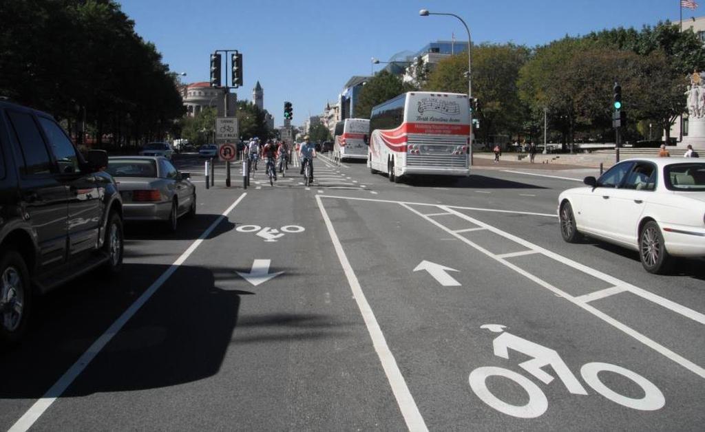
3 15 th Street NW The first physically separated bike lanes in the City Two-way cycle track Protected by Parking Lane


4 15th Street, NW Cycle Track Two-way for Bikes Residential One Way North for Cars Two Way for Cars Downtown CBD Two-way for Bikes


5 15 th Street Before North Half 4 lanes 1-way North Residential Neighborhood Concerns of safety, traffic speeds Posted speed th Percentile between mph Excess capacity 6 to 12,000 ADT South Half 6 to 7 lanes, 2-way Downtown


6 15 th St. After North Half Removed 1 NB auto lane Protected left-turns LOS drop of one letter grade at most intersections South Half Removed 1 auto lane One Way North Residential CBD Two Way


7 Signalization Challenges of Bidirectional Cycletracks 15 th St has 46 Intersections 21 signal control 6 uncontrolled minor streets 4 parking garage drives 1 hotel driveway 11 alleys 3 residential driveways Same direction bicyclist crashes with left turning vehicles is the primary danger where utilizing two way roadway and cycle track designs
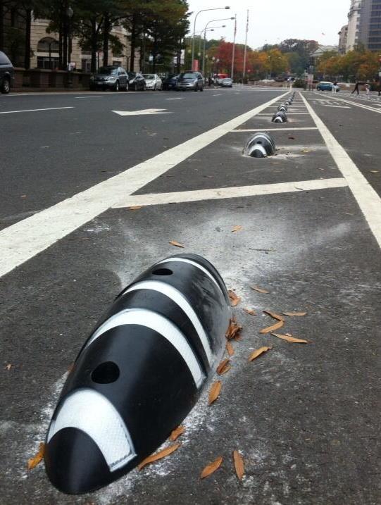
8 Controlled Intersection. Left Turn Conflict Mitigation, one-way section Separate phasing Left arrow/lane Leading bike/ped phase Parking restriction Bike SSD 50 feet Chicane bike approach designed for 10 mph Shifts cyclist to line of sight of approaching motorists Flex post keep cars in lane No color in bike xwalk
9 Controlled Intersection. Left Turn Conflict Mitigation, one-way section Separate phasing Left arrow/lane Leading bike/ped phase Parking restriction Bike SSD 50 feet Chicane bike approach designed for 10 mph Shifts cyclist to line of sight of approaching motorists Flex post keep cars in lane No color in bike x-walk
10 Controlled Intersection. Left Turn Conflict Mitigation, one-way section Separate phasing Left arrow/lane Leading bike/ped phase Parking restriction Bike SSD 50 feet Chicane bike approach designed for 10 mph Shifts cyclist to line of sight of approaching motorists Flex post keep cars in lane No color in bike x-walk


11 Uncontrolled Intersection Mitigations Parking restriction on approach Chicane cycle track approaching conflict Flex posts up to crosswalk Bike symbols within conflict zone Signs Replace parking to minimize complaints
")

12 Two-way traffic CBD mitigations Fully protect left turns Left turn prohibitions at 3 locations (to reduce traffic delay) Parking restrictions to create right turn lanes for 100 feet RTOR prohibited Separate bike crosswalk Leading Bike/Ped Interval of 3 seconds _
13 Pennsylvania Avenue, NW Center median bike lanes with buffers Turn lane and signals for cars turning left across the bike path

14 Pennsylvania Ave. Before Dozen WMATA bus routes Tour bus loading zones Flush median portions with parking Limited curb side parking with some VIP and valet High pedestrian volumes (up to 2,000/hr/intersection)
 Excellent Vehicular LOS ADT - 35,000 vehicles per day Not a")
15 Pennsylvania Ave. Before Mix of left turn treatments (protected /restricted /permitted) Excellent Vehicular LOS ADT - 35,000 vehicles per day Not a through route all vehicles turn off to congested north/south routes Inauguration Parade & other local & national events
16 Pennsylvania Ave. Before

17 Pennsylvania Ave. After Median cycle track Avoids bus & other curb conflicts No Left Turn easier to enforce than No Right Turn Auto left turns prohibited or changed to protected only phasing Bike turns via crosswalks, following ped signals

18 Pennsylvania Ave After

19 Pennsylvania Ave. After
20 Pennsylvania Ave After

21 Pennsylvania Ave Illegal u-turns

22 Pennsylvania Ave After After


23 L Street Parking and Loading Impacts North Side Parking Removed South Side Parking during non rush-hours Loading zones on south side and side streets Reduction in redundant signs/clutter
24 L Street NW Left Turn Typical Car/bike merge area cars must yield to through bikes Left-turn lane Green through bike lane Mix zone adherence vs. perception
25 14 th St to Connecticut Ave Connecticut Ave to 28 th St M STREET, NW

26 M Street NW Right Turn Typical Section

27 1 st St NE First hard-barrier cycletrack


28 Measures of Success: Goals of 15 th St Cycle Track Pilot Increase bicycle trips Improve safety for all modes Calm traffic Minimize motorist delay Provide more options for cyclists Provide DDOT with a better understanding for future cycle tracks


29 Research Overview One Year Three projects: Safety 16 th, U, New Hampshire Pennsylvania Avenue 15 th Street Compliance with traffic laws Modal interactions Crash analysis Traffic volumes Operations Multi-modal LOS Convenience Multi-modal travel time Comfort Intercept & neighborhood surveys 15 th St, NW 15 th St, NW 16 th St, U St, New Hampshire Ave NW 16 th St, U St, New Hampshire Ave NW


30 Highlights of Research Results 15 th St Increase bicycle trips Over 500% increase in bicyclist volumes Improve safety for all modes Bicycle crashes increased but remained similar when adjusted for exposure No increase for other modes Calm traffic > 45 mph -98% > 25 mph -60% Minimize motorist delay Motor vehicle volumes remained the same Minor changes in LOS Provide DDOT with a better understanding for future cycle tracks Bicycle signals are important, but be cautious which intersection you choose to signalize Consider coloring conflict zones Improve signal progression for southbound (contra-flow) movement
, easier (98%), more convenient (98%), and would go out of their way")


31 Highlights of Research Results 15 th St Cyclists Cyclists believe that the cycle track makes riding a bicycle safer (96%), easier (98%), more convenient (98%), and would go out of their way to ride in it (93%). Up to 39% of riders do not understand what traffic signal they should follow. Cyclists violate traffic signals 41% of the time. Residents 81% agree that DC should be investing in projects that encourage more people to ride bicycles for transportation. 83% think that the cycle track is a valuable neighborhood asset Only 45% think bicycling in DC is safe Benchmarking Report
32 Highlights of Research Results Pennsylvania Ave, NW Arterial LOS was similar for motor vehicles before and after the bicycle facilities were installed. Motor vehicle volumes decreased between 15% and 21% since the installation of the bike facilities. Cyclists Cycling volume increased over 300%. Cyclists believe that the center bike lanes make riding a bicycle safer (90%), easier (94%), more convenient (92%), and would go out of their way to ride in it (86%). Cyclists understand what traffic signal to follow, but frequently don t obey: 42% violate the red signal indication. 26% indicated that they would stop in the crosswalk, a potential safety hazard due to the path of left-turning vehicles. Bicycle crashes have increased: 16 in 14 months versus 9 during previous 4 years. Pedestrians 75% notice fewer cyclists on the sidewalks since the installation of the center bike lanes. 33% feel that crossing the street is more difficult with the center bike lanes. Motorists 69% think that there are fewer cyclists in the car lanes due to the bike facility. 84% like that bicycles are separated from the motor vehicle traffic. Residents 74% agree that DC should be investing in projects that encourage more people to ride bicycles for transportation. 71% think that the cycle track is a valuable neighborhood asset. Only 33% think bicycling in DC is safe.

33

 c. Pedestrian Refuge Crossing Island d.")

34 Vision Zero & MoveDC Multi-Modal Plan policy foundations: 1. Crosswalk Marking Policy - Recommends enhancements for crosswalks multi-lane arterials with high traffic volumes: a. Pedestrian Hybrid Beacon ( HAWK ) b. Rectangular Rapid Flash Beacon (RRFB) c. Pedestrian Refuge Crossing Island d. Uncontrolled Crosswalk Side-of-Street Sign 2. Bus stop alignment with safer crossings 3. Curb Extensions 4. Leading Pedestrian Interval Signal Timing 5. Complete Streets Policy 6. Vision Zero Reduce speeding and reduce crash severity
35
36 DC Pedestrian Crash Types Pedestrian Action, No Code Against Signal in Crosswalk From Between Parked Cars In Unmarked Crosswalk In Crosswalk - No Signal Not in Crosswalk With Signal in Crosswalk Other Unknown
37 Most Frequent DC Ped Crash Types Uncontrolled crosswalk- Fail to yield


38 High Risk Motorist At-Fault Crashes, Unsignalized Multiple Threat crash In crosswalk, no signal, multiple threat

39 Safety Effects of Marked vs. Unmarked Crosswalks at Uncontrolled Locations (Zegeer, 2002):

40 FHWA Crosswalk Compliance Matrix Zegeer Study, FHWA, 2002
41 FHWA Guidance on Uncontrolled Crosswalks New marked crosswalks alone, without other measures designed to reduce traffic speeds, shorten crossing distances, enhance driver awareness of the crossing, and/or provide active warning of pedestrian presence, should not be installed across uncontrolled roadways where the speed limit exceeds 40 mph and either: A. The roadway has four or more lanes of travel without a raised median or pedestrian refuge island and an ADT of 12,000 vehicles per day or greater; or B. The roadway has four or more lanes of travel with a raised median or pedestrian refuge island and an ADT of 15,000 vehicles per day or greater MUTCD, Section 3B-18 (page 384)
42 DDOT Uncontrolled Crosswalk Policy Matrix Volumes Below 1500 vpd Treatment A Treatment B Treatment C Treatment D Parallel Crosswalk and/or W11-2 assembly High Visibility Crosswalk and Side of Street Ped Law Sign In-Street Stop For Peds Sign and/or Traffic Calming Activated Pedestrian Device (RRFB, In-road LEDs, etc.) Something with a red signal (Ped Hybrid, Full Signal)

43 Uncontrolled Crosswalk Compliance by Corridor

44 DC HAWK Preliminary Evaluation Form Planning department conducts preliminary evaluation If score is sufficiently high, Signals Team conducts formal Warrant Study


45 Uncontrolled Crosswalks: For Use at selected uncontrolled crosswalks on major arterial streets HAWK Pedestrian Hybrid Beacon/Signal


46 HAWK Pedestrian Hybrid Beacons in DC Major roadway sees a beacon/signal Minor roadway sees a stop sign Dark when not in use FHWA Study: Up to a 69% reduction in pedestrian crashes Up to a 29% reduction in total crashes. DDOT study showed 97% compliance No problem observed with stopcontrolled side street Minor roadway gets less cutthrough traffic


47 Operational Issues with the PHB/HAWK in DC 1. Some drivers do not understand that they may proceed on Flashing Red: Not observed as a safety problem Reduces somewhat the operational advantage of the PHB DDOT posted a sign to help explain the Flashing Red phase 2. Some reports of drivers moving on the Flashing Red in a manner that seemed hazardous to pedestrians: Lengthen the solid red phase Enforcement

48 PHBs in the suburban context Most pedestrian fatalities occur at mid-block crossings or on multi-lane roadways at non-signalized locations.
49 PHB Warrant - MUTCD
 study published in 2010 found that pedestrian hybrid beacons can reduce pedestrian crashes by 69 percent and")
50 FHWA PHB Guide, 2014 PHBs have been shown to significantly reduce pedestrian crashes. A Federal Highway Administration (FHWA) study published in 2010 found that pedestrian hybrid beacons can reduce pedestrian crashes by 69 percent and total crashes by 29 percent. /ped bike

51 DC HAWK Brochure


52 Rectangular Rapid Flashing Beacon (RRFB): Pedestrian actuated, solar powered, high intensity LED beacons that flash in a stutter pattern at approaching drivers 7 Locations in DC Interim Approval from FHWA (2008)

53 RRFB Evaluation Results- Baseline

54 RRFB Evaluation Results- 100 days
55


56
57 Why Road Diets? Do you want to slow speeders, especially top end speeders? Do you want to reduce right angle, sideswipe and rear-end crashes? (29%-53%) Do you want to make it safer and easier for people to cross the street? Do you want to improve conditions for cycling? Do you want the street to support more nonmotorized human activity?


58 Sherman Ave. NW Road Diet, 2013 After.85 mile, mainly residential BEFORE: 4 travel lanes On street parking No bike facility No sidewalk buffer


59 Sherman Ave. NW Road Diet, 2013 After: 2 travel lanes LT pockets Raised, landscaped median On street parking 14 wide shared lane Added 4 ft. tree/grass buffer to each side.

60 Sherman Ave. NW After: Example of the give and take required to right size a street and make a former auto-dominated corridor with poor pedestrian, bike and transit facilities function as a complete street. After
: Before, northbound- 32 mph After, northbound- 29 mph Before, southbound- 35 mph After, southbound- 28 mph Crashes: Total crashes- 23%")
61 Sherman Ave. NW Road Diet Evaluation Study: 85%ile Speeds (25 mph posted): Before, northbound- 32 mph After, northbound- 29 mph Before, southbound- 35 mph After, southbound- 28 mph Crashes: Total crashes- 23% decline Injury crashes- 44% decline Auto Mobility: Traffic volumes: Before: 15,000 ADT. After: 13,000 ADT Intersection delay: One LOS B before to D after. All others are LOS C or better. Bicycle LOC: Before: D, After C+


62 Sherman Ave. NW Road Diet Forward to the Past
63 Road diet candidate guidelines (DPS-201 Course) ADT (Road Diet Candidate) 23,000 or less (suburban) 17,000 or less (urban) Peak hour peak direction volume (Road Diet Candidate) 1,200 or less (suburban) 950 or less (urban) Other factors: Percentage of left turns at intersection VPH on side street These apply IF you want to accommodate existing traffic volumes (discuss ) Look for opportunities to implement Road Diets

64 George Branyan Pedestrian Program Coordinator District Department of Transportation
Designing for Pedestrian Safety in Washington, DC
 Designing for Pedestrian Safety in Washington, DC February 25, 2014 George Branyan Pedestrian Program Coordinator District Department of Transportation DC Journey to work mode split: 2012 Means of Transportation
The DC Pedestrian Master Plan
 The DC Pedestrian Master Plan September 28, 2010 George Branyan Pedestrian Program Coordinator District Department of Transportation Presentation Agenda Scope of the Plan Methodology Recommendations Implementation
Active Transportation Facility Glossary
 Active Transportation Facility Glossary This document defines different active transportation facilities and suggests appropriate corridor types. Click on a facility type to jump to its definition. Bike
STATUS OF 2009 PEDESTRIAN MASTER PLAN (AS OF DECEMBER 2013)
") Appendix P.1 STATUS OF 2009 PEDESTRIAN MASTER PLAN (AS OF DECEMBER 2013) The 2009 Pedestrian Master Plan establishes 21 core recommendations in three goal areas to improve pedestrian transportation in
Appendix P.1 STATUS OF 2009 PEDESTRIAN MASTER PLAN (AS OF DECEMBER 2013) The 2009 Pedestrian Master Plan establishes 21 core recommendations in three goal areas to improve pedestrian transportation in
MEMORANDUM. Charlotte Fleetwood, Transportation Planner
 MEMORANDUM Date: Updated August 22, 2017 To: Organization: Charlotte Fleetwood, Transportation Planner Boston Transportation Department From: Jason DeGray, P.E., PTOE, Regional Director of Engineering
UNCONTROLLED PEDESTRIAN CROSSING GUIDELINES
 City and County of Denver UNCONTROLLED PEDESTRIAN CROSSING GUIDELINES Prepared for: Prepared by: Adopted September 2016 This page is intentionally left blank. Contents for Denver Uncontrolled Pedestrian
Bicycle Facilities Planning
 Bicycle Facilities Planning Overview Types of Cyclists Purpose for Riding Types of Facilities Bike Lanes Bicycle Boulevards Cycle Tracks Intersections Signals Signing and Marking Discussion Types of Bicyclists
Designing for Pedestrian Safety
 Designing for Pedestrian Safety Treatments at Unsignalized Pedestrian Crossings Presented by: Charlie Zegeer PBIC Director August 17, 2010 Crossing Crashes Part 1: General Principles 3 2 Why do people
PEDESTRIAN SAFETY IMPROVEMENT EVALUATION GUIDELINE FOR UNCONTROLLED CROSSINGS
 PEDESTRIAN SAFETY IMPROVEMENT EVALUATION GUIDELINE FOR UNCONTROLLED CROSSINGS Traffic Safety Engineering Division Updated: April 2018 EXECUTIVE SUMMARY NDOT Traffic Safety Engineering Division developed
Dr. M.L. King, Jr. Street North Complete Streets Resurfacing Opportunities HOUSING, LAND USE, AND TRANSPORTATION COMMITTEE MARCH 22, 2018
 Dr. M.L. King, Jr. Street North Complete Streets Resurfacing Opportunities HOUSING, LAND USE, AND TRANSPORTATION COMMITTEE MARCH 22, 2018 What s Happening The City plans to mill and resurface Dr. M.L.
HAWK Signal. Pedestrian Safety. Illinois Traffic Engineering & Safety Conference Thursday, October 21, 2010
 HAWK Signal Pedestrian Safety Illinois Traffic Engineering & Safety Conference Thursday, October 21, 2010 Background Information High-intensity Activated crosswalk Developed by the City of Tuscon, AZ First
GLOSSARY CROSSWALK. CROSSING TYPES
 CROSSWALK The part of a roadway at an intersection included within the connections of the lateral lines of the sidewalks on opposite sides of the street measured from the curbs, or in the absence of curbs
Draft North Industrial Area-Wide Traffic Plan
 Summary of North Industrial and Hudson Bay Industrial Recommended Improvements Table 1. Summary of s Item Location 1 2 3 4 5 6 7 8 9 10 11 12 Millar Ave north of 51st St Super 8 Motel back lane 400 Block
Effective Pedestrian & Bicycle Safety Enforcement
 Effective Pedestrian & Bicycle Safety Enforcement October 20, 2011 George Branyan Pedestrian Program Coordinator District Department of Transportation Increasingly multi-modal region Change in Daily Trip
Town of Windsor Pedestrian Crossing Guidelines
 Town of Windsor Pedestrian Crossing Guidelines Prepared for: Town of Windsor Engineering Department 301 Walnut Street Windsor, Colorado 80550 For More Information, please contact: Engineering Department
Development of Arlington County s Marked Crosswalk Guidelines. Jon Lawler, P.E. Design Engineer Arlington County, VA
 Development of Arlington County s Marked Crosswalk Guidelines Jon Lawler, P.E. Design Engineer Arlington County, VA April 13, 2015 Transportation System Users Residents Estimated 215,000 in 2014 Lowest
Designing for Pedestrian Safety. Alabama Department of Transportation Pre-Construction Conference May 2016
 Designing for Pedestrian Safety Alabama Department of Transportation Pre-Construction Conference May 2016 1 Designing for Pedestrians Marking Crosswalks at Signalized intersections High Visibility Markings
Bay to Bay Boulevard Complete Streets Project
 Bay to Bay Boulevard Complete Streets Project Dale Mabry Highway to Bayshore Boulevard February 08, 2018 Photo Source: Tampa Bay Times Alessandra Da Pra Meeting Format Introduction Resurfacing Information
City of Albert Lea Policy and Procedure Manual 4.10 ALBERT LEA CROSSWALK POLICY
 4.10 ALBERT LEA CROSSWALK POLICY PURPOSE: Pedestrian crosswalks are an integral part of our transportation infrastructure. To be effective and promote safety, marked crosswalks must be installed after
Project Team. Refined Pedestrian Crossing Toolbox. Problem Statement. Aerial of Study Corridor. Crossing Accommodations and Pedestrian Fatalities
 Project Team Refined Pedestrian Crossing Toolbox Treatments on Wide, High Speed Urban Roadways Developed as Part of the Springfield Main Street (OR 126) Safety Study Consultants Scott Mansur, P.E., P.T.O.E.
Broad Street Bicycle Boulevard Design Guidelines
 Broad Street Bicycle Boulevard Design Guidelines Building from the strategies introduced in the 2013 Bicycle Transportation Plan and community input received thus far, City Transportation Staff have identified
In response to your request for information on mid-block pedestrian crossing policies and guidelines, the following information is enclosed:
 August 18, 2016 City of Brentwood, Tennessee Mr. Kirk Bednar City Manager 5211 Maryland Way P. O. Box 788 Brentwood, Tennessee 37024 VIA ELECTRONIC MAIL Dear Mr. Bednar: In response to your request for
Bicycle Boulevards and Neighborhood Greenways
 Bicycle Boulevards and Neighborhood Greenways Traffic Safety is Improving for Everyone 90 80 70 60 50 40 30 20 10 0 PORTLAND: TOTAL TRAFFIC FATALITIES 1986-2008 1986 1987 1988 1989 1990 1991 1992 1993
Appendix A: Crosswalk Policy
 Appendix A: Crosswalk Policy Appendix A: Crosswalk Policy Introduction This citywide Crosswalk Policy is aimed at improving pedestrian safety and enhancing pedestrian mobility by providing a framework
Chapter 5: Crossing the Street
 Chapter 5: Crossing the Street Whether walking or bicycling, a student s journey to school will more than likely require crossing one or more streets. Per the Safe Routes to School Guide, maintained by
C/CAG. Sunnybrae Elementary School Walking and Bicycling Audit. San Mateo-Foster City School District JUNE 2013
 Sunnybrae Elementary School Walking and Bicycling Audit JUNE 2013 San Mateo-Foster City School District C/CAG City/County Association of Governments of San Mateo County SUNNYBRAE ELEMENTARY SCHOOL WALKING
Rightsizing Streets: The Seattle Experience
 Rightsizing Streets: The Seattle Experience April 30, 2013 Brian Dougherty Seattle Department of Transportation Complete Streets 16% of households do not have a car Seniors Youth Transit riders Safety
MEMORANDUM. Date: 9/13/2016. Citywide Crosswalk Policy
 MEMORANDUM Date: 9/13/2016 Re: Citywide Crosswalk Policy Foreword Through the s Circulation Element and Complete Streets Policy, it is the City s goal to promote walking trips and provide safe facilities
Guidance for Installation of Pedestrian Crosswalks on Michigan State Trunkline Highways
 Guidance for Installation of Pedestrian Crosswalks on Michigan State Trunkline Highways Michigan Department of Transportation July 7, 2014 Engineering Manual Preamble This manual provides guidance to administrative,
Road Diets FDOT Process
 Florida Department of TRANSPORTATION Road Diets FDOT Process Humberto Castillero, PE, PTOE Roadway Design Office Purpose of Guide Develop a statewide lane elimination review process Balance state & local
INTERSECTION DESIGN TREATMENTS
 Designing for Bicyclist Safety INTERSECTION DESIGN TREATMENTS LEARNING OUTCOMES Understand intersection design options and features Select appropriate design feature for a bikeway in a given context C1
Caltrans Sloat Boulevard Pedestrian Safety Project Response to Community Questions, Comments & Concerns
 Caltrans Sloat Boulevard Pedestrian Safety Project Response to Community Questions, Comments & Concerns Revised: May 10, 2016 The California Department of Transportation (Caltrans) is planning various
TRAFFIC IMPACT ANALYSIS
 TRAFFIC IMPACT ANALYSIS FOR THE CHAMPAIGN UNIT#4 SCHOOL DISTRICT PROPOSED HIGH SCHOOL (SPALDING PARK SITE) IN THE CITY OF CHAMPAIGN Final Report Champaign Urbana Urbanized Area Transportation Study 6/24/2014
SPEED MANAGEMENT FOR VISION ZERO
 SPEED MANAGEMENT FOR VISION ZERO LUANN HAMILTON, DEPUTY COMMISSIONER FOR PROJECT DEVELOPMENT CHICAGO DEPARTMENT OF TRANSPORTATION NACTO DESIGNING CITIES 2017 Vision Zero Action Plan Speed management and
Walk Friendly Communities Engineering Strategies. Carl Sundstrom Walk Friendly Communities Workshop Grandview, MO June 2015
 Walk Friendly Communities Carl Sundstrom Walk Friendly Communities Workshop Grandview, MO June 2015 Module Overview Topics Background and purpose Sidewalks Crossings Traffic calming www.pedbikeimages.org
Broadway Street Pedestrian Safety Study Cass Street to 700 Feet North of Randall Avenue
 Broadway Street Pedestrian Safety Study Cass Street to 700 Feet North of Randall Avenue Prepared for: City of De Pere, Wisconsin Prepared by: June, 2017 Broadway Street Pedestrian Safety Study Cass Street
C. Best Practice Pedestrian Treatment Toolbox
 C. Best Practice Pedestrian Toolbox The Best Practice Pedestrian Toolbox presents the recommended tools in striping, signalization, signage, geometry and other categories for improving both uncontrolled
Appendix C. City of Fort Collins Recommended Bicycle Design Guidelines. Appendix C: Recommended Bicycle Design Guidelines 1
 Appendix C City of Fort Collins Recommended Bicycle Design Guidelines Appendix C: Recommended Bicycle Design Guidelines 1 This appendix provides general design considerations for implementation of bicycle
2018 AASHTO BIKE GUIDE
 2018 AASHTO BIKE GUIDE Your presenters Jessica Fields, PE Denver Office Director Sagar Onta, PE, PTOE Denver Engineering Director 35 years of combined experience street design, transportation planning,
Northbound San Jose Avenue & I-280 Off-Ramp Road Diet Pilot Project
 Project Overview Fed by a two-lane Interstate-280 (I-280) off-ramp, high vehicular volumes and speeds are longstanding issues along San Jose Avenue. Residents in the surrounding neighborhoods have expressed
Establishing Procedures and Guidelines for Pedestrian Treatments at Uncontrolled Locations
 1 Establishing Procedures and Guidelines for Pedestrian Treatments at Uncontrolled Locations Yan Qi Southern Illinois University Edwardsville 66th Illinois Traffic Engineering and Safety Conference Champaign,
Improving Pedestrian Safety at Unsignalized Crossings. Shawn Turner, P.E. Texas A&M Transportation Institute
 Improving Pedestrian Safety at Unsignalized Crossings Shawn Turner, P.E. Texas A&M Transportation Institute Overview of Presentation What are the issues/problems? Framework for crossing treatments Marked
PEDESTRIAN CROSSING SOLUTIONS ANDREA HARTH, PE, PTOE TEC ENGINEERING, INC.
 PEDESTRIAN CROSSING SOLUTIONS ANDREA HARTH, PE, PTOE TEC ENGINEERING, INC. Pedestrian Safety 2017 Pedestrian Crashes in Ohio Crash Severity Number % Fatal Crash 141 4.9% Injury Crash 2546 89.1% Property
Pedestrian Treatments by
 Pedestrian Treatments by Kay Fitzpatrick Texas A&M Transportation Institute TxDOT Short Course October 15-16, 2013 Recent Research Efforts FHWA Studies Crosswalk markings Driver yielding (DY) at rectangular
Pedestrian Hybrid Beacon Guide Recommendations and Case Study. FHWA Safety Program.
 Pedestrian Hybrid Beacon Guide ecommendations and Case Study FHWA Safety Program http://safety.fhwa.dot.gov A pedestrian hybrid beacon (PHB) is a traffic control device similar to a European pedestrian
CITY OF SARATOGA SPRINGS PEDESTRIAN CROSSING TOOLBOX
 CITY OF SARATOGA SPRINGS PEDESTRIAN CROSSING TOOLBOX This toolbox is to be used to guide pedestrian crossing improvements within the City of Saratoga Springs. Details for each crossing type are provided.
Chapter 2: Standards for Access, Non-Motorized, and Transit
 Standards for Access, Non-Motorized, and Transit Chapter 2: Standards for Access, Non-Motorized, and Transit The Washtenaw County Access Management Plan was developed based on the analysis of existing
PEDESTRIAN CROSSING TREATMENTS
 PEDESTRIAN CROSSING TREATMENTS BEST PRACTICES Presented by: Doug Enderson, P.E., PTOE Cody Salo, P.E. 1 PRESENTER INTRODUCTIONS Doug Enderson, P.E., PTOE Ped Crossing Experience: ADA Design-Build ADA Inventory
Potential Bicycle Facility on Bayou Street Mobile, Alabama
 Potential Bicycle Facility on Bayou Street Mobile, Alabama By Richard A. Hall, P.E. Prepared For Mobile Downtown Alliance Hall Planning & Engineering, Inc. March 28, 2018 Introduction Review of the February
REGIONAL BICYCLE AND PEDESTRIAN DESIGN GUIDELINES
 REGIONAL BICYCLE AND PEDESTRIAN DESIGN GUIDELINES November 16, 2011 Deb Humphreys North Central Texas Council of Governments Bicycle and Pedestrian Advisory Committee Snapshot of the Guide 1. Introduction
Creating Complete Streets to Accommodate All Users
 Creating Complete Streets to Accommodate All Users Peter Lagerwey, Toole Design Group plagerwey@tooledesign.com Brian Dougherty, Seattle DOT brian.dougherty@seattle.gov International Conference on Urban
Safety Benefits of Raised Medians and Pedestrian Refuge Areas. FHWA Safety Program.
 Safety Benefits of Raised Medians and Pedestrian Refuge Areas FHWA Safety Program http://safety.fhwa.dot.gov There s a signal up the block, but looking left there s a gap in traffi c. Looking right there
PEDESTRIAN ACCOMMODATIONS DPS 201 AT INTERCHANGES
 PEDESTRIAN ACCOMMODATIONS DPS 201 AT INTERCHANGES UNDERSTANDING THE ISSUES Intersections of freeway ramp terminals at crossroads are the most critical components of an interchange Challenge: balance mobility
Guidelines for Pedestrian Treatments at Uncontrolled Locations January 18, 2018
 Est. Dec. 2014 Guidelines for Pedestrian Treatments at Uncontrolled Locations January 18, 2018 Presented by: Kyle Armstrong, Illinois DOT Yan Qi, Southern Illinois University Webinar Logistics Duration
PEDESTRIAN ACCOMMODATIONS DPS 201 AT ROUNDABOUTS
 PEDESTRIAN ACCOMMODATIONS DPS 201 AT ROUNDABOUTS WHY THEY WORK FOR PEDESTRIANS IF DESIGNED CORRECTLY Separated sidewalks direct peds to crosswalks Splitter island Slow speed exit Truck apron Crosswalk
Balancing Operation & Safety for Motorized and Non-Motorized Traffic
 Balancing Operation & Safety for Motorized and Non-Motorized Traffic Brian Willham, PE, PTOE Iowa Director - MOVITE June 30, 2014 Learning Objectives: When & Why should we measure the performance of complete
Who is Toole Design Group?
 2018 AASHTO Bike Guide Status Update NCHRP 15 60 Amalia Leighton Cody, PE, AICP & Kenneth Loen, PE Washington APWA October 4, 2018 Who is Toole Design Group? TDG is a full service engineering, planning
Effective Pedestrian & Bicycle Safety Enforcement
 Effective Pedestrian & Bicycle Safety Enforcement August 29, 2013 George Branyan Pedestrian Program Coordinator District Department of Transportation Sgt. Terry Thorne Special Operations Division Metropolitan
Transportation Planning Division
 Transportation Planning Division Presentation Outline Study Tasks Recap of Previous Meetings Data Collected Focus Areas within Study Limits Design Principles Tool Box Recommended Concepts Schedule Moving
Simulation Analysis of Intersection Treatments for Cycle Tracks
 Abstract Simulation Analysis of Intersection Treatments for Cycle Tracks The increased use of cycle tracks also known as protected bike lanes has led to investigations of how to accommodate them at intersections.
Physical Implications of Complete Streets Policies
 Presentation Overview Physical Implications of Complete Norm Cox, ASLA, LLA Landscape Architect Ann Arbor, Michigan, 10:45 to Noon What Are Complete Streets? What Matters to Bicyclists and Pedestrians
COWETA HIGH SCHOOL AND EAST HIGHWAY 51
 COWETA HIGH SCHOOL AND EAST HIGHWAY 51 Lack of sidewalks along Ben Lumpkin Rd. Lack of crosswalks and ramps at intersection. Hwy 51 is wide to cross as a pedestrian. No ADA compliance or connection to
Acknowledgements. Mr. David Nicol 3/23/2012. Daniel Camacho, P.E. Highway Engineer Federal Highway Administration Puerto Rico Division
 Daniel Camacho, P.E. Highway Engineer Federal Highway Administration Puerto Rico Division Acknowledgements Mr. David Nicol Director, FHWA Office of Safety FHWA Office of Safety http://safety.fhwa.dot.gov/provencountermeasures/
Peer Review of Highlands Neighborhood Traffic and Pedestrian Safety Plan
 FINAL REPORT March 14, 2017 Prepared for: Ada County Highway District Prepared by: SIX MILE ENGINEERING, PA Executive Summary The (Highlands Safety Plan) developed by the Ada County Highway District (ACHD)
BETHEL ROAD AND SEDGWICK ROAD CORRIDOR STUDY
 DRAFT PLAN City Council Meeting August 14, 2017 STUDY AREA Sedgwick Corridor State Route 160, principal arterial with Class 3 access management designation, commuter and freight route, connection to SR
Clybourn Ave. Protected Bike Lane Study Halsted St. to Division St.
 Clybourn Ave. Protected Bike Lane Study Halsted St. to Division St. Nathan Roseberry, Senior Engineer Pam Broviak, Project Manager July 24, 2014 Agenda Project Goals Existing Roadway Conditions Traffic
Appendix C. TRAFFIC CALMING PROGRAM TOOLBOX
 Appendix C. TRAFFIC CALMING PROGRAM TOOLBOX PHASE I...2 Do Not Enter Sign...3 One-Way Sign...4 Turn Prohibition...5 Pavement Markings...6 Speed Monitoring Trailer...7 Neighborhood Speed Watch...8 Police
Multimodal Analysis in the 2010 Highway Capacity Manual
 Multimodal Analysis in the 2010 Highway Capacity Manual It s not just cars anymore! Jamie Parks, AICP HCAT Conference May 9-10, 2011 Multimodal LOS in the 2010 HCM History and background Overview of methods
2018 AASHTO BIKE GUIDE
 2018 AASHTO BIKE GUIDE Your presenter Rob Burchfield, PE NW Regional Engineering Director 35 years of experience in traffic engineering and bicycle facility design Toole Design Group Toole Design Group
Multimodal Through Corridors and Placemaking Corridors
 68 Multimodal Through Corridors and Placemaking Corridors Corridors have different functions in a region. Some corridors are used to get smoothly and rapidly through a region or to get quickly to major
Addendum to SDDCTEA Pamphlet 55 17: Better Military Traffic Engineering Revision 1 Effective: 24 Aug Crosswalk Guidelines
 Addendum to SDDCTEA Pamphlet 55 17: Better Military Traffic Engineering Revision 1 Effective: 24 Aug 2017 Crosswalk Guidelines Warrants for Uncontrolled Crosswalk Locations Crosswalks at Midblock Locations
TOWN OF MORAGA MORAGA WAY AND CAMINO PABLO/CANYON ROAD IMPROVEMENTS Town Council Meeting March 13, 2019
 TOWN OF MORAGA MORAGA WAY AND CAMINO PABLO/CANYON ROAD IMPROVEMENTS Town Council Meeting March 13, 2019 1 Edric Kwan, Public Works Director Josh Peterman, Principal, Fehr and Peers Shawn Knapp, Senior
WELCOME Public Information Centre
 WELCOME Public Information Centre Fernforest Drive Brampton Soccer Centre Community Room #2 Tuesday January 19, 2016 6:30 p.m.to 9:00 p.m. Please sign in Neighbourhood Traffic Calming Guide Background
Traffic Engineering Update on Bike/Ped Topics. Marc Lipschultz, P.E. PTOE Central Office Traffic Engineering Division
 Traffic Engineering Update on Bike/Ped Topics Marc Lipschultz, P.E. PTOE Central Office Traffic Engineering Division Bicycle/Pedestrian Advisory Committee August 3, 2016 Agenda Share the Road / Bikes May
System Performance Innovation FACT Sheet Hawk Pedestrian Beacon
 Hawk Pedestrian Beacon Description of the Challenge or Opportunity Hawk Pedestrian Beacon Understanding the motivation. Describe the pre-existing product/process that is the subject of the innovation:
Cycle Track Design Best Practices Cycle Track Sections
 Design Best Practices Sections It is along street segments where the separation and protection methods of cycle tracks offer more comfort than conventional bicycle lanes, and are more attractive to a wide
TODAY S WEBINAR AGENDA
 TODAY S WEBINAR AGENDA 3:00 pm: Introduction 3:05 pm: Presentation 3:45 pm: Questions 4:00 pm: Webinar Ends For technical assistance during the webinar: 1-800-263-6317 Choose these prompts: 1, 1, 1 CONTINUING
Welcome! San Jose Avenue Open House August 25, 2015
 Welcome! San Jose Avenue Open House August 25, 2015 Vision Zero The City and County of San Francisco adopted Vision Zero San Francisco Vision Zero High Injury Network as a policy in 2014, committing an
Pedestrians and Bicyclists. Bruce Friedman and Scott Wainwright FHWA MUTCD Team
 Impact of the New MUTCD on Pedestrians and Bicyclists Bruce Friedman and Scott Wainwright FHWA MUTCD Team Development of the 2009 MUTCD NPA published in the Federal Register on January 2, 2008 Received
IMPROVING PEDESTRIAN SAFETY AT UNCONTROLLED CROSSINGS. Guidelines for Marked Crosswalks
 IMPROVING PEDESTRIAN SAFETY AT UNCONTROLLED CROSSINGS Presented by Nazir Lalani P.E. Traffex Engineers Inc. N_lalani@hotmail.com Guidelines for Marked Crosswalks Source: FHWA, Safety Effects of Marked
RE: City of Portland Request to Experiment with HAWK/Bike signal
 October 4, 2005 Regina S. McElroy, Director Office of Transportation Operations HOTO Room 3401 400 7 th Street, S.W. Washington, D.C. 20590 RE: City of Portland Request to Experiment with HAWK/Bike signal
El Camino Real Specific Plan. TAC/CAC Meeting #2 Aug 1, 2018
 El Camino Real Specific Plan TAC/CAC Meeting #2 Aug 1, 2018 Land Use Alternatives Goals and Tradeoffs Parks & open space Housing Retail & services Civic spaces Parking Community gathering spaces 3 Alternatives
APPENDIX A: Complete Streets Checklist DRAFT NOVEMBER 2016
 APPENDIX A: Complete Streets Checklist DRAFT NOVEMBER 2016 Complete Streets Checklist MetroPlan Orlando s Complete Streets Checklist is an internal planning tool for staff to further implementation of
City of Cape Coral Traffic Calming. City Council May 16,
 City of Cape Coral Traffic Calming City Council May 16, 2016 1 In This Presentation Why Traffic Calming? What is Traffic Calming? Examples Traffic Calming in the City of Cape Coral How to develop a Traffic
DPS 201 RECTANGULAR RAPID FLASHING BEACON (RRFB)
") DPS 201 RECTANGULAR RAPID FLASHING BEACON (RRFB) WHY? PEDESTRIANS NEED TO CROSS CASE STUDY: RRFB (ST. PETERSBURG, FL) St. Petersburg, FL Problem/Background Multi-lane, high-speed roadways Conflicts at
DPS 201 RECTANGULAR RAPID FLASHING BEACON (RRFB) WHY? PEDESTRIANS NEED TO CROSS CASE STUDY: RRFB (ST. PETERSBURG, FL) St. Petersburg, FL Problem/Background Multi-lane, high-speed roadways Conflicts at
Off-road Trails. Guidance
 Off-road Trails Off-road trails are shared use paths located on an independent alignment that provide two-way travel for people walking, bicycling, and other non-motorized users. Trails specifically along
City of Vallejo Traffic Calming Toolbox
 City of Vallejo Traffic Calming Toolbox June 1, 2013 Final Table of Contents Introduction... 1 Non-Physical Devices... 3 High-Visibility Crosswalk... 3 In Pavement Lighted Crosswalk... 4 Rapid Flashing
City of Wilsonville 5 th Street to Kinsman Road Extension Project
 City of Wilsonville 5 th Street to Kinsman Road Walking Tour & Neighborhood Workshop Summary Report Public Outreach Overview On July 18 th, 2017, the City of Wilsonville hosted a neighborhood walking tour
EXECUTIVE SUMMARY. Vision
 Vision Walking and bicycling in Salt Lake City will be safe, convenient, comfortable, and viable transportation options that connect people to places, foster recreational and economic development opportunities,
CONTRA COSTA Countywide Bicycle and Pedestrian Plan. Appendix C Best Practices: Pedestrian and Bicycle Treatments
 CONTRA COSTA Countywide Bicycle and Pedestrian Plan Appendix C Best Practices: Pedestrian and Bicycle Treatments The preparation of this report has been financed through a grant from the U.S. Department
Military Road Safety Improvements
 Military Road Safety Improvements 26 th Road North to 31 st Street North SUMMARY OF DATA REVIEW AND PRELIMINARY RECOMMENDATIONS Prepared for: Department of Environmental Services Traffic Engineering and
How to Develop a Pedestrian Safety Action Plan
 How to Develop a Pedestrian Safety Action Plan Course Introduction Presented by: Peter Eun FHWA RC Safety Engineer Ryan Snyder President, Ryan Snyder Associates, LLC Paul Zykofsky Director, Land Use and
DEPARTMENT OF ENVIRONMENTAL SERVICES. North Harrison Street (Lee Highway to Little Falls Road) Comparative Analysis. Prepared for:
 Comparative Analysis. Prepared for:") DEPARTMENT OF ENVIRONMENTAL SERVICES North Harrison Street (Lee Highway to Little Falls Road) Comparative Analysis Prepared for: Arlington County Department of Environmental Services 2100 Clarendon Boulevard,
DEPARTMENT OF ENVIRONMENTAL SERVICES North Harrison Street (Lee Highway to Little Falls Road) Comparative Analysis Prepared for: Arlington County Department of Environmental Services 2100 Clarendon Boulevard,
EVALUATION OF HAWK SIGNAL AT GEORGIA AVENUE AND HEMLOCK STREET, NW IN THE DISTRICT OF COLUMBIA FINAL REPORT. August 30, 2010
 EVALUATION OF HAWK SIGNAL AT GEORGIA AVENUE AND HEMLOCK STREET, NW IN THE DISTRICT OF COLUMBIA FINAL REPORT August 30, 2010 Submitted to: Mr. George Branyan Pedestrian Program Manager Policy, Planning
Neighborhood Pedestrian Safety and Traffic Calming Study
 Neighborhood Pedestrian Safety and Traffic Calming Study for the area bounded by Foster Avenue, Bedford Avenue, Farragut Road and Ocean Avenue Flatbush, Brooklyn, New York prepared by Michael King, miking@trafficcalmer.com
2014 FHWA Aging Road User Handbook. Recommendations to Accommodate Aging Pedestrians. Lifesaver National Conference. What is the Handbook?
 2014 FHWA Aging Road User Handbook Recommendations to Accommodate Aging Pedestrians Lifesaver National Conference March 17, 2015 Revised June 2014 1 What is the Handbook? 1998 1st Edition 2001 2nd Edition
Access Management in the Vicinity of Intersections
 Access Management in the Vicinity of Intersections FHWA-SA-10-002 Technical Summary Photo: Ralph Bentley (used with permission) 0 Access Management is: The design, implementation and management of entry
Agenda. Overview PRINCE GEORGE S PLAZA METRO AREA PEDESTRIAN PLAN
 PRINCE GEORGE S PLAZA METRO AREA PEDESTRIAN PLAN May 28, 2008 Agenda Welcome and introductions Project overview and issue identification Planning context and strengths Design challenges and initial recommendations
Document 2 - City of Ottawa Pedestrian Crossover (PXO) Program
 Program") 40 Document 2 - City of Ottawa Pedestrian Crossover (PXO) Program OVERVIEW The City of Ottawa Pedestrian Crossover (PXO) Program provides the basis for PXO implementation in Ottawa. The program s processes
40 Document 2 - City of Ottawa Pedestrian Crossover (PXO) Program OVERVIEW The City of Ottawa Pedestrian Crossover (PXO) Program provides the basis for PXO implementation in Ottawa. The program s processes
Project Goal and Description. Why Broadway? Broadway SFMTA.COM/BROADWAY. The goal of the Broadway Safety Improvement
 PROJECT OVERVIEW Project Goal and Description The goal of the Broadway Safety Improvement d St Van Ness Ave Project is to improve safety and comfort for all who Franklin St Hyde St Octavia St Gough St