Item No. 8.1 Transportation Standing Committee June 28, 2018
|
|
|
- Harriet Beasley
- 5 years ago
- Views:
Transcription
1 P.O. Box 1749 Halifax, Nova Scotia B3J 3A5 Canada Item No. 8.1 Transportation Standing Committee June 28, 2018 TO: Chair and Members of Transportation Standing Committee Original Signed SUBMITTED BY: Bruce Zvaniga, P.Eng., Director, Transportation and Public Works Original Signed Jacques Dubé, Chief Administrative Officer DATE: May 17, 2018 SUBJECT: Supplementary Report Herring Cove Sidewalk Request ORIGIN February 22, 2018 Transportation Standing Committee motion (Item ): MOVED by Councillor Smith, seconded by Councillor Mason THAT Transportation Standing Committee defer consideration of the November 21, 2017 staff report pending receipt of a supplementary staff report with possible creative, immediate solutions for prioritized pedestrian safety that can be implemented in 2018/19. MOTION PUT AND PASSED. LEGISLATIVE AUTHORITY Halifax Regional Municipality Charter, Section 322(1): The Council may design, lay out, open, expand, construct, maintain, improve, alter, repair, light, water, clean, and clear streets in the Municipality. Halifax Regional Municipality Charter, Section 79(1): Council may expend money required by the Municipality for: (aa) streets, culverts, retaining walls, sidewalks, curbs and gutters. Halifax Regional Municipality Charter, Section 79(1): Council may expend money required by the Municipality for: (ah) playgrounds, trails [ ] bicycle paths [ ] and other recreational facilities. RECOMMENDATION It is recommended that Transportation Standing Committee recommend that Regional Council direct staff to continue detailed design for the implementation of a new permanent street cross-section on Herring Cove Road from Lynnett Road to Civic 554, including sidewalks, bike lanes, bus stops and other elements and consider it for the capital budget, rather than pursue an interim option in 2018.
, the staff report Herring Cove Road Sidewalk Request dated November 21, 2017 described planning and engineering design work underway to install pedestrian facilities along Herring Cove Road")

2 Supplementary Report Herring Cove Sidewalk Request Transportation Standing Committee Report June 28, 2018 BACKGROUND At the February 22 nd, 2018 meeting of Transportation Standing Committee (TSC), the staff report Herring Cove Road Sidewalk Request dated November 21, 2017 described planning and engineering design work underway to install pedestrian facilities along Herring Cove Road from Lynnett Road to Civic 554 (Attachment A). The report explained the rationale for why construction is targeted for 2019, pending available budget and Council approval of that budget. The staff recommendation was that the report be forwarded to Regional Council as an information item. TSC deferred consideration of this report (copy in Attachment A) and requested that staff explore an interim measure that could be installed to improve pedestrian safety and comfort until the sidewalks are constructed. DISCUSSION Consideration of Interim Solutions When tasked with finding an interim measure for improved sidewalk safety, staff discussed temporary measures such as: Bollards; Paint; Jersey barriers and/or water-filled plastic barriers; Curb stops / parking stops; Precast concrete curb; and, Planters. The majority of these solutions would be successful in creating the perceived separation between pedestrians and vehicles (with the exception of paint). Pedestrians may feel more comfortable using this space. Further, the effect is a visually narrowed roadway that has the potential to slow traffic and alert drivers to the pedestrian area (see Figure 1, Figure 2). Figure 1: Painted Jersey Barrier on Highway Figure 2: Pedestrian Improvements by Painting Roadway and Adding Bollards The following factors were considered in developing an interim solution: 1. Cost There is no approved budget for such a project in 2018/19, so a separate request to Council would likely have to be made. The estimated cost of an interim solution would be $330,000 (see page 5). 2. Accessibility (including accessible surface width) The interim solution should not create a situation that is less accessible than the existing condition. It is necessary that the interim solution be fully accessible for users of all ages and abilities. Users should be able to freely move around the barriers and along the protected surface without obstacle.

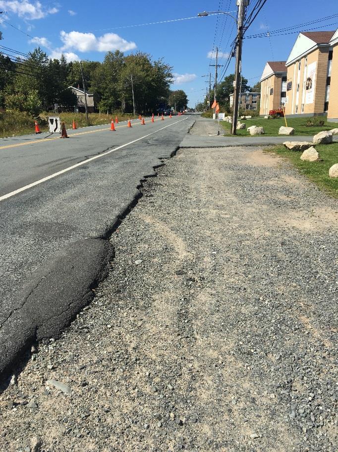
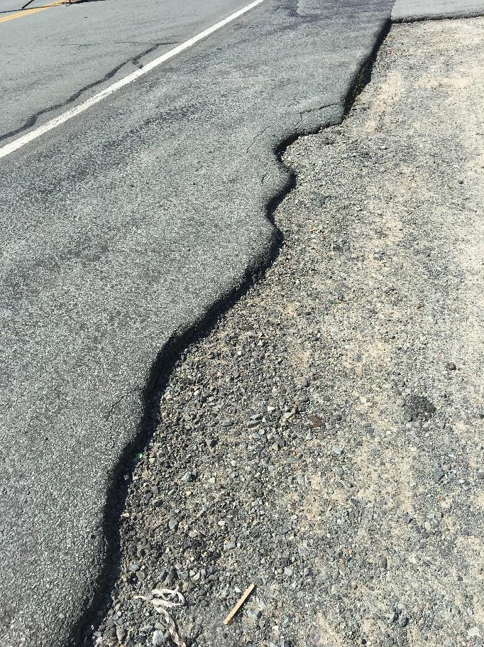
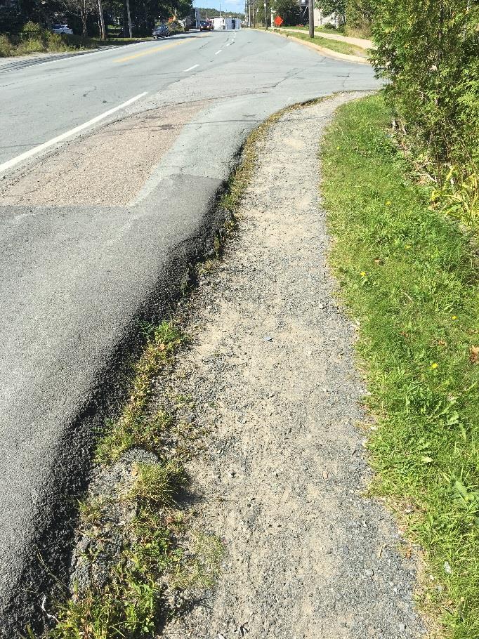
3 Supplementary Report Herring Cove Sidewalk Request Transportation Standing Committee Report June 28, Safety While many of the interim design treatments (e.g. bollards, paint, curb stops, planters) may enhance feelings of safety in pedestrians, they are not able to physically stop a car should the need arise. This may lead to a false sense of security and reduced vigilance when interacting with traffic, particularly in a higher speed context. 4. Driveways, curbside loading, and bus stops The interim solution must allow continued curbside access for Halifax transit and not interfere with passenger boarding from the three bus stops along this segment. The Redbook recommends a minimum 14.5m gap in temporary barriers to maintain transit access. There are also five wide driveways (7-13m) which would require further gaps in the temporary sidewalk protection. Treatments such as jersey barriers and planters may obscure the view and would require special treatments (e.g. tapered barriers) on either side of each driveway to improve safety and visibility. 5. Drainage Attaching a barrier to the roadway e.g. jersey barrier, water filled plastic barrier, and/or curb stops may impact drainage on the street. It would be important to ensure that water does not collect on either the road-side or the pedestrian-side of the barrier and lead to standing water and/or ice in the winter. 6. Winter maintenance and visibility Some barriers (e.g. bollards) may create difficulties with snow clearing in the winter. Plows have been known to sweep bollards away -- their bases are prone to catching on the blades of snow clearing equipment. Low-height barriers such as curb stops may need to have bollards to ensure they are visible. Regardless of which design treatment or barrier style is chosen, professional standards recommend a 0.6m (2ft) offset buffer from the white line on the edge of the travel lane for safety purposes. This would be taken from the existing 2m (6.5ft) paved shoulder that is already sub-standard and crumbling in most sections (Figure 3, Figure 4). If the barrier itself takes approximately 0.3m (1ft), the result of what s left would be a crumbling shoulder that is 1.1m (3.5ft) or less in width. Figure 3: Inconsistent Shoulder Width Sept 2017 Figure 4: Crumbling Shoulder Sept 2017
 state that new pedestrian infrastructure should be accessible for people of all ages and abilities. Staff are concerned that this new 1.1m (3.")
4 Supplementary Report Herring Cove Sidewalk Request Transportation Standing Committee Report June 28, 2018 Policies from the Integrated Mobility Plan (3.1.5a) state that new pedestrian infrastructure should be accessible for people of all ages and abilities. Staff are concerned that this new 1.1m (3.5ft) paved shoulder width may be impassable for people in wheelchairs or pushing strollers. To achieve this accessible width of 1.8m (6ft), the existing shoulder would have to be removed and replaced with a widened and repaved new shoulder. Interim Solution Option Considering the above factors, the option developed in response to TSC s request for possible creative, immediate solutions for prioritized pedestrian safety that can be implemented in 2018/19 is as follows: Figure 5: Cross Section of Interim Solution with Curb Stops and Repaved Shoulders The preferred interim option as identified by Staff is to widen and repave the shoulder on the east side, then place concrete curb stops as a delineator/barrier along the edge of the interim sidewalk (see Figure 5 for a concept technical drawing with widths). Inspiration comes from an installation in Seattle, WA involving paved shoulders with stamped asphalt and curb stops (Figure 6). This is the preferred solution because: 1. It achieves a small barrier between the paved shoulder and the roadway that will visually narrow the roadway and alert vehicles of the possibility of pedestrians; 2. It is easier and more cost-effective to install vs larger jersey barriers; 3. Placement can be modified more easily than jersey barriers; 4. There are less issues around visibility and driveway entrances; and, 5. Curb stops can be stepped over by pedestrians if absolutely necessary. Figure 6: Temporary Sidewalk Installation in Seattle, Washington
5 Supplementary Report Herring Cove Sidewalk Request Transportation Standing Committee Report June 28, 2018 The interim option involves adding temporary sidewalk on the east side of Herring Cove Road only. Extending the repaved shoulders and curb stops to the west side of the street would be challenging as the ditches would need to be infilled and a stormwater system installed. This stormwater infrastructure is costly and should not be considered as part of a temporary solution. It is not advisable to install a stormwater system until the permanent cross-section (including lane widths and placement) is determined. Anticipated Cost The total cost of this project is around $330,000 +HST including a 30% contingency. Section 1: Lynnett St to Civic 532 Section 2: Civic 532 to Civic 554 $130,000 including 2.0m repaved shoulder $200,000 including curb stop delineators and East side only 1.8m repaved shoulder East side only This money is not currently available in the capital budget for installation this summer. If Council chooses to pursue this option, staff would need to return to Audit and Finance Committee to seek approval of a funding source. If the interim option to be implemented, it would have to be completely removed when the permanent infrastructure is constructed. Staff Assessment This interim solution is not recommended by staff for the following reasons: 1. Curb stop barriers could only be incorporated on the east side of Herring Cove Road between Civic 532 and Civic 554. Property issues between Lynnett St and Civic 532 make it impossible to widen the shoulder meaning that this section will just be repaved to 2.0m (6.5ft) without the addition of the barriers; and, 2. The widened and repaved asphalt sidewalks will need to be removed when the permanent sidewalks are constructed, which are being designed for construction in 2019 (pending available budget). This may not be a prudent use of limited capital budget. FINANCIAL IMPLICATIONS There are no financial implications associated with the recommendation of this report. RISK CONSIDERATION The original Recommendation Report (Attachment A) identified no significant risks. No new or significant risks have emerged based on the recommendations contained in this Supplementary Report. COMMUNITY ENGAGEMENT On April 25 th, AT Staff were invited to meet with eight members of the Spryfield Community Association to discuss work completed on the project to date, and to get their community perspective on the temporary design options. Staff shared images of what the temporary option with curb stops could look like and described the criteria that were used in determining this option. Staff explained that while implementing a sidewalk on this section of Herring Cove Road is a priority, there are no guarantees that it could be built in 2019 without budget approval. However, staff are continuing with the detailed design and property acquisition process and noted that this is identified as a priority project in the Integrated Mobility Plan. The primary concerns of the group were: vehicular speed, crosswalk safety, project timelines, and the community perception of a second-rate sidewalk. The consensus of the group was that they would prefer to wait one year for a high-quality sidewalk than to implement the temporary option discussed.
6 Supplementary Report Herring Cove Sidewalk Request Transportation Standing Committee Report June 28, 2018 ENVIRONMENTAL IMPLICATIONS This project is supportive of the sustainability objectives of the Municipality as it aims to make it safer and more comfortable for residents to choose sustainable transportation options for everyday transportation purposes. ALTERNATIVES Transportation Standing Committee may recommend to Regional Council that the temporary sidewalk design described in this report, including $330,000 plus net HST of repaved shoulders and curb stop barriers, be approved and implemented in summer 2018, subject to the identification and approval of a funding source by Audit and Finance Standing Committee. This alternative is not recommended based on the discussion above. ATTACHMENTS Attachment A February 22, 2018 Report to TSC Herring Cove Sidewalk Request A copy of this report can be obtained online at halifax.ca or by contacting the Office of the Municipal Clerk at Report Prepared by: Siobhan Witherbee, Active Transportation Planner,
7 P.O. Box 1749 Halifax, Nova Scotia B3J 3A5 Canada Item No Transportation Standing Committee February 22, 2018 TO: Chair and Members of Transportation Standing Committee SUBMITTED BY: Original Signed Bruce Zvaniga, P.Eng., Director, Transportation and Public Works DATE: November 21, 2017 SUBJECT: Herring Cove Road Sidewalk Request ORIGIN February 8, 2017 Committee of the Whole motion (Item 7). MOVED by Councillor Adams, seconded by Councillor Whitman THAT Committee of the Whole request a staff report outlining the cost of installing sidewalk on the Herring Cove Road from Lynnett Road to 564 Herring Cove Road including potential sources of funding from other municipal funds and with a view to having this installation take place in 2017/18. MOTION PUT AND PASSED. LEGISLATIVE AUTHORITY Halifax Regional Municipality Charter, Section 322(1): The Council may design, lay out, open, expand, construct, maintain, improve, alter, repair, light, water, clean, and clear streets in the Municipality. Halifax Regional Municipality Charter, Section 79(1): Council may expend money required by the Municipality for: (aa) streets, culverts, retaining walls, sidewalks, curbs and gutters. Halifax Regional Municipality Charter, Section 79(1): Council may expend money required by the Municipality for: (ah) playgrounds, trails [ ] bicycle paths [ ] and other recreational facilities. RECOMMENDATION It is recommended that Transportation Standing Committee forward this report to Regional Council for information.
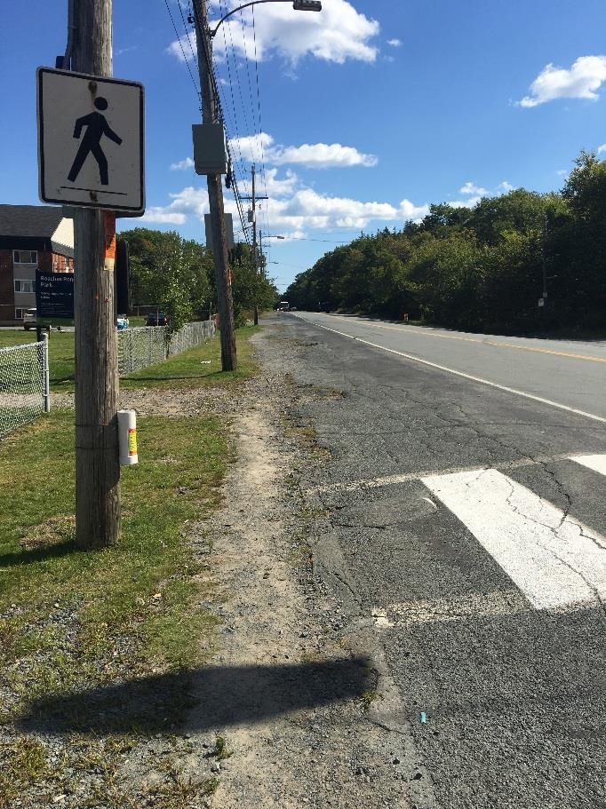
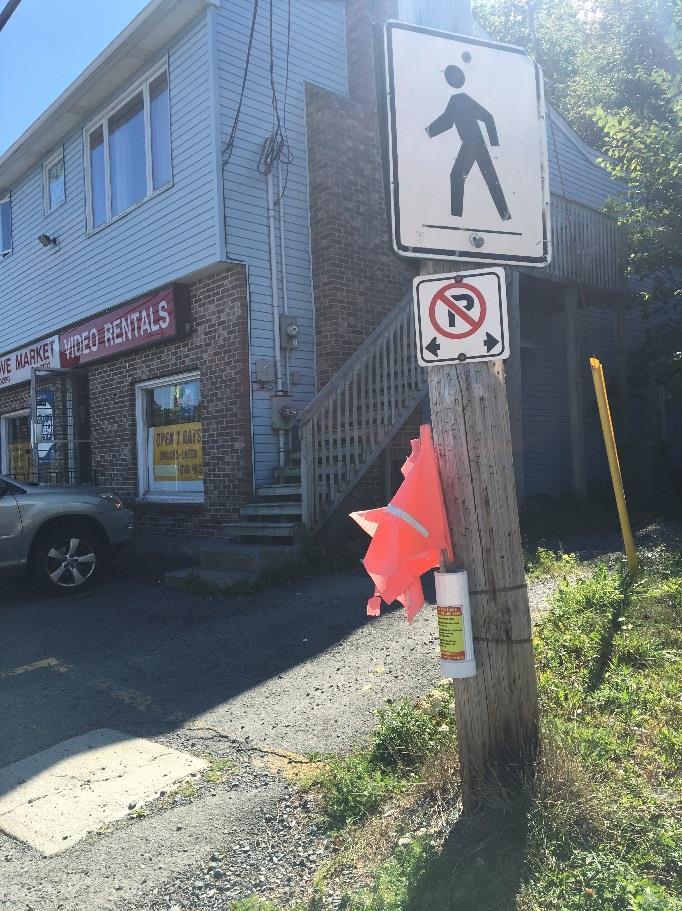
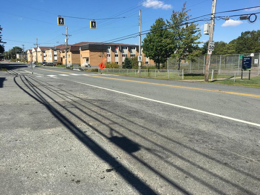
8 Herring Cove Sidewalk Request Transportation Standing Committee Report February 22, 2018 BACKGROUND New Sidewalk Assessment Tool and Prioritization Requests for new sidewalks are typically submitted through the area councillor or through HRM s 311 service. The requested road segments are then evaluated based on a number of criteria including proximity to schools, daycares, seniors homes, commercial and high-density residential areas, parks, and public transit stops. Requests are also considered if the sidewalk fills a gap by connecting two existing areas with a new sidewalk or if there are safety concerns due to poor sightlines, high motor vehicle volumes or speeds. Each request is scored and placed onto a list that currently has over 400 new sidewalk locations for prioritization. Approximately 5-10 new sidewalk projects are constructed annually based on funding availability and project integration opportunities (e.g. road repaving projects). Based on the new sidewalk criteria this segment of Herring Cove Road ranks HIGH on the prioritization list for construction. Neighbourhood Context and Existing Sidewalk Condition Herring Cove Road is the main thoroughfare for the community of Spryfield (population approx. 13,500). Much of the commercial activity, higher-density residential buildings and transit are clustered along this corridor. Similar to other pre-amalgamation suburban arterials, Herring Cove Road was not built with adequate pedestrian infrastructure. Some sidewalks and paved shoulders have been installed over the years to meet localized demand, however, large gaps still exist. A continuous sidewalk currently exists on the west side of Herring Cove Road connecting Spryfield to the Armdale roundabout as far as Greystone Drive (4.7 km), however, not all sections are up to standard. There is intermittent sidewalk on the east side of Herring Cove Road with the longest segment existing between McMullen Road and Lynnett Road (2.6 km). There are paved shoulders on the east side of Herring Cove Road south of Lynnett Road, and on the west side south of Greystone to facilitate walking (Attachment A). A small segment of asphalt sidewalk facilitates access to a bus stop/shelter (approx. 60m) on the east side of Herring Cove Road near the intersection of McIntosh Street. Social Considerations Many residents of Herring Cove Road between Lynnett Road and Civic 564 rely on transit and walking as their primary means of transportation. These paved shoulders are well used as they pass in front of a row of apartment buildings where residents walk to and from the bus stops, nearby schools, community centres and shops. Residents with disabilities as well as parents pushing strollers are frequently observed traveling on the paved shoulder in this area. Improving the active transportation infrastructure along this section of Herring Cove Road is necessary to improve comfort and safety for a high density of residents getting to and from their destinations. Safety Considerations The relatively straight, wide lanes along this segment of Herring Cove Road may contribute to the high vehicular speed in this area. A nearby speed study 1 found that approximately 1 in 7 vehicles exceeded the 50 km/h speed limit by more than 10 km/h along this segment. Of greatest concern, there have been recent vehicular-pedestrian collisions along this segment. Proposed Herring Cove Road Future Widening Project The need for sidewalks along this segment of Herring Cove Road has been discussed in previous years. The project has been on hold in part due to the uncertainty around road widening from two lanes to four 1 Speed study was conducted in August 2016 for inbound vehicles only in front of 647 Herring Cove Road.
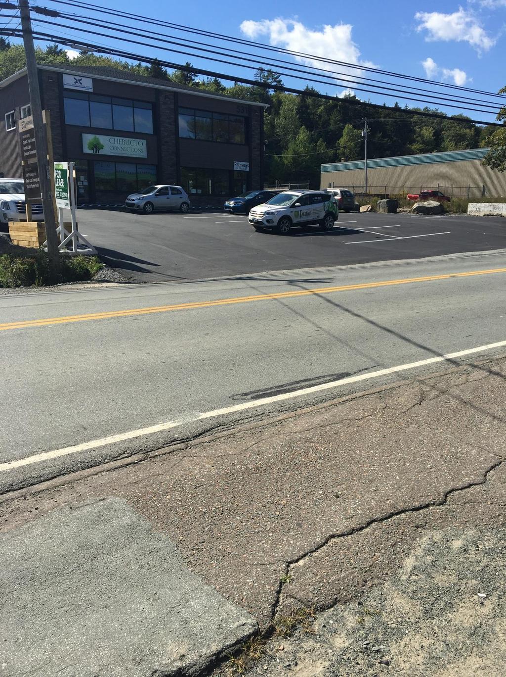
9 Herring Cove Sidewalk Request Transportation Standing Committee Report February 22, 2018 lanes. The 2014 Regional Plan identifies the widening of Herring Cove Road from the Armdale Rotary to Old Sambro Road as a potential project, however, there was no clear timeframe established for its completion. It is unlikely that the project would impact the study area further up Herring Cove Road between Lynnett Road and Civic 564 in the near future. Related Active Transportation Policy In April 2010, Regional Council endorsed the International Charter for Walking, a symbolic commitment to promote active transportation, physical activity, community planning and environmental sustainability in the Municipality. The Active Transportation Priorities Plan (AT Plan) was adopted by Regional Council in The primary goal of the document is to establish a complete, integrated, and readily available region-wide AT network serving urban, suburban, and rural areas. The AT Plan identifies that there are incomplete sidewalk networks in Fairview, Spryfield, Dartmouth and the business parks. The AT Plan identifies the segment of Herring Cove Road between Lynnett Road and Civic 564 as a highly rated segment for a new sidewalk connection. The Integrated Mobility Plan recommended that the Municipality continue to focus efforts on establishing AT connections within communities outside the Regional Centre. Action 69 of the Integrated Mobility Plan identified three major sidewalk connections to be completed by 2020; this segment of Herring Cove Road along between Lynnett Road and Civic 564 is one of them. Bicycle Lanes Herring Cove Road is identified in the AT Plan as a Proposed Bicycle Route on Major Road. Community desire for bicycle lanes along this segment was also identified in the community engagement sessions of the Integrated Mobility Plan. Functional study of Herring Cove Road should also include the consideration of bicycle facilities and connectivity along this corridor as part of a complete streets approach. Bicycle lanes currently exist on Herring Cove Road between Sarah Drive and Hebridean Drive (2.3km). Additionally, the provincial government has been proactively adding bicycle lanes and paved shoulders on nearby rural roads (e.g. Ketch Harbour Road, Old Sambro Road) to create an on-road recreational cycling loop. Bicycle lanes on Herring Cove Road from Lynnett Road to Civic 564 would eventually connect to this cycling loop and assist in continuing the network into the city. DISCUSSION As the above section illustrates, the addition of sidewalks and bicycle lanes along this segment of Herring Cove Road is supported by HRM policy and plans, the sidewalk assessment tool, safety considerations and policy direction from the Integrated Mobility Plan. As a result, staff is planning how to implement the project and reviewing costs, possible property requirements, and overall project scope. Estimated Cost This is a large scale project with full implementation costs estimated at $2.8 million (Class D estimate). This includes 1.8m sidewalk on both sides, 1.5m painted bike lane on both sides, new curb, gutter, drainage systems, road resurfacing, and street trees. While the focus of this project is providing pedestrian infrastructure due to the nature of the current road, some of the highest costs associated with this project would be installation of a drainage system. Given that the proposed budget for active transportation capital projects (sidewalks, multi-use pathways and bike lanes) in is $4.1 million, a project of this magnitude is challenging to implement. Staff has explored the feasibility of a smaller project to establish the most critical sidewalk connections in the 2018 construction year. The concept that was explored was to build sidewalks only to connect Lynnett Road to Civic 564 on the east side of Herring Cove Road, and Greystone Drive to Civic 531 (Chebucto
10 Herring Cove Sidewalk Request Transportation Standing Committee Report February 22, 2018 Connections) on the west side. However, the cost estimated for this intermediary project is $2.3 million (Class D estimate), with very little savings associated with the significant downscaling of infrastructure. If the municipality moves forward with constructing portions of sidewalk, the installation of the expensive drainage system is still required. The option of a smaller-scale project that may have been implemented on a faster timeframe is not recommended as there is minimal cost savings and for additional reasons as outlined below. Property Issues Investigation for this report led to the discovery that there is no legal survey available for this section of Herring Cove Road. Due to sporadic property acquisition for the future widening of Herring Cove Road, the property line adjacent to the HRM right-of-way is uneven and occasionally unclear. It is difficult to plan and construct a consistent cross section until the Municipality knows which land it legally owns and how much width is available. Upon realization of this gap, staff engaged a consultant to review the necessary documentation and conduct the legal survey of upwards of 50 properties along Herring Cove Road. This is a lengthy process that will take several months to complete. Results are expected in early-mid Herring Cove Road Functional Study Concurrently, while Project Planning and Design staff are reviewing options for sidewalks and bicycle lanes along this segment, the Transportation Planning group from Planning and Development are about to initiate a planning study of the full Herring Cove Road corridor. This planning study will aim to develop a complete vision of Herring Cove Road from the roundabout to the Hebridean Drive. The study will address pedestrian needs, vehicle and transit needs, recommended bicycle facilities and overall street design. This planning process for Herring Cove Road will assist in establishing the cross-section that would be built for the segment in question from Lynnett Road to Civic 564. Next Steps Although staff recognize the importance of this project and have explored avenues for the project to be constructed in 2018, the limiting factors are: o Lack of legal survey for this section of Herring Cove Road; o $2.8 million project cost including new drainage system; o Partial implementation or intermediary step is still costly at $2.3 million; and, o Requirement of a complete streets review of Herring Cove Road which includes the segment from Lynnett Road to Civic 564. Current and future actions to implement this project include: o Continued planning and design (conducting legal survey, understanding and planning for new drainage system, producing revised cost estimates, etc.); o Conducting a full planning study of Herring Cove Road corridor; and, o Budgeting and project planning to position installation of sidewalk and bicycle lanes on Herring Cove Road from Lynnett Road to Civic 564. At this time, it is anticipated the planning and detailed design phases can be completed in time to consider a 2019 construction of a new sidewalk and bicycle facilities from Lynnett Road to Civic 564. Additional review is required through the budget process to determine available funding and project planning to support the Herring Cove Road project. As with any project, detailed engineering design challenges may be identified that could impact the timing and cost of the project.
11 Herring Cove Sidewalk Request Transportation Standing Committee Report February 22, 2018 FINANCIAL IMPLICATIONS There are no immediate financial implications associated with the recommendations in this report. In 2018/19, staff will continue project planning and design in preparation for implementing this project in the 2019/20 budget year and construction season, if feasible. RISK CONSIDERATION There are no significant risks associated with the recommendations in this Report. The risks considered rate Low. COMMUNITY ENGAGEMENT Two community groups in this area brought forward the request for consideration of new sidewalks in the budget Chebucto Connections and the Spryfield Community Association. According to the community groups, new sidewalks along the 500 block of Herring Cove Road would improve safety of neighbourhood children walking to school, and facilitate at-risk students attending after school tutoring programs at Chebucto Connections, where there is currently no sidewalk (or safe access). Recent public engagement from the Integrated Mobility Plan in November 2016 and February 2017 identified the desire for improved infrastructure for walking and cycling along Herring Cove Road. Many of the people walking and cycling along this road feel unsafe due to the combination of vehicular speed and narrow/ crumbling sidewalks and shoulders. The specific segment between Greystone Drive and Civic 554 is identified as a priority sidewalk connection to be implemented by ENVIRONMENTAL IMPLICATIONS This project is supportive of the sustainability objectives of the Municipality as it aims to make it safer and more comfortable for residents to choose sustainable transportation options for everyday transportation purposes. ALTERNATIVES Transportation Standing Committee may not wish to forward this report to Regional Council for information. ATTACHMENTS Attachment A: Context Map and Proposed Sidewalk Connections Attachment B: Photos from Site Visit September 2017 A copy of this report can be obtained online at halifax.ca or by contacting the Office of the Municipal Clerk at Report Prepared by: Siobhan Witherbee, Active Transportation Planner,


12 GREYSTONE FORBES Lynett Road Park LYNNETT MCINTOSH AUTUMN N Chebucto Connections ===> Cove Market & Video ===> HERRING COVE Roaches Pond Park Attachment A Context: Herring Cove Road New Sidewalk Request Existing Sidewalks Proposed Sidewalks with Bike Lane Parcel Boundaries Building Footprints Municipal Parks Ocean Schools Key Bus Stops
13 Attachment B: Photos from Site Visit September 2017
14
15
Item No Halifax Regional Council January 16, 2018 January 30, 2018
 P.O. Box 1749 Halifax, Nova Scotia B3J 3A5 Canada Item No. 9.2.1 Halifax Regional Council January 16, 2018 January 30, 2018 TO: Mayor Savage and Members of Halifax Regional Council Original Signed SUBMITTED
Chair and Members of Transportation Standing Committee. Bruce Zvaniga, P.Eng., Director, Transportation and Public Works
 P.O. Box 1749 Halifax, Nova Scotia B3J 3A5 Canada Item No. 12.1.1 Transportation Standing Committee December 7, 2017 TO: Chair and Members of Transportation Standing Committee SUBMITTED BY: ORIGINAL SIGNED
P.O. Box 1749 Halifax, Nova Scotia B3J 3A5 Canada Item No. Halifax Regional Council January 16, 2017
 P.O. Box 1749 Halifax, Nova Scotia B3J 3A5 Canada Item No. Halifax Regional Council January 16, 2017 TO: Mayor Savage and Members of Halifax Regional Council SUBMITTED BY: Jacques Dubé, Chief Administrative
CITY OF SAINT JOHN TRAFFIC CALMING POLICY
 CITY OF SAINT JOHN TRAFFIC CALMING POLICY VERSION: 1.0 April 10, 2012 Pedestrians, Cyclists and Motorists Sharing Street Spaces CONTENTS INTRODUCTION... 3 POLICY GOAL... 3 POLICY OBJECTIVES... 3 GUIDING
TRAFFIC CALMING GUIDE FOR TORONTO CITY OF TORONTO TRANSPORTATION SERVICES DIVISION
 TRAFFIC CALMING GUIDE FOR TORONTO CITY OF TORONTO TRANSPORTATION SERVICES DIVISION CITY OF TORONTO TRANSPORTATION SERVICES DIVISION 2016 TRAFFIC CALMING GUIDE FOR TORONTO TABLE OF CONTENTS Introduction
P.O. Box 1749 Halifax, Nova Scotia B3J 3A5 Canada Item No Halifax Regional Council September 18, 2018
 P.O. Box 1749 Halifax, Nova Scotia B3J 3A5 Canada Item No. 14.1.6 Halifax Regional Council September 18, 2018 TO: SUBMITTED BY: Mayor Savage and Members of Halifax Regional Council Original Signed Jacques
Active Transportation Facility Glossary
 Active Transportation Facility Glossary This document defines different active transportation facilities and suggests appropriate corridor types. Click on a facility type to jump to its definition. Bike
CITY OF COCOA BEACH 2025 COMPREHENSIVE PLAN. Section VIII Mobility Element Goals, Objectives, and Policies
 CITY OF COCOA BEACH 2025 COMPREHENSIVE PLAN Section VIII Mobility Element Goals, Objectives, and Policies Adopted August 6, 2015 by Ordinance No. 1591 VIII MOBILITY ELEMENT Table of Contents Page Number
Chapter 3 DESIGN SPECIFICATIONS
 Brampton PathWays Planning and Design Guidelines 27 Chapter 3 DESIGN SPECIFICATIONS 3.1 CLASS 1 MULTI-USE PATH Off-road multi-use trails are the backbone of the Brampton PathWays Network. They are typically
Item No Halifax Regional Council March 6, 2018
 P.O. Box 1749 Halifax, Nova Scotia B3J 3A5 Canada Item No. 14.3.2 Halifax Regional Council March 6, 2018 TO: SUBMITTED BY: Mayor Savage and Members of Halifax Regional Council Original Signed Councillor
Cyclists and Bikeways: What s your match? A guide to bikeway options for a variety of cyclists
 Cyclists and Bikeways: What s your match? guide to bikeway options for a variety of cyclists The workshop and this resource were made possible by funding from the Province of Ontario via the Ministry of
City of Charlottesville Bicycle and Pedestrian Master Plan Update
 City of Charlottesville Bicycle and Pedestrian Master Plan Update September 17, 2014 I. Welcome and meeting overview II. Project status update III. Network overview IV. Break-out groups Pedestrian Network
CONNECTIVITY PLAN. Adopted December 5, 2017 City of Virginia Beach
 CONNECTIVITY PLAN Adopted December 5, 2017 City of Virginia Beach CONTENTS 1.0 Background & Purpose... 2 2.0 Existing Inventory & Analysis... 3 ViBe District Existing Walking Conditions... 4 3.0 ViBe District
Tonight is for you. Learn everything you can. Share all your ideas.
 Strathcona Neighbourhood Renewal Draft Concept Design Tonight is for you. Learn everything you can. Share all your ideas. What is Neighbourhood Renewal? Creating a design with you for your neighbourhood.
Cycle Track Design Best Practices Cycle Track Sections
 Design Best Practices Sections It is along street segments where the separation and protection methods of cycle tracks offer more comfort than conventional bicycle lanes, and are more attractive to a wide
Item No Transportation Standing Committee June 23, 2016
 P.O. Box 1749 Halifax, Nova Scotia B3J 3A5 Canada Item No. 12.1.2 Transportation Standing Committee June 23, 2016 TO: SUBMITTED BY: Chair and Members of Transportation Standing Committee Original Signed
Active Transportation Infrastructure Investment A Business Case
 Active Transportation Infrastructure Investment A Business Case In 2016, the Real Estate Foundation awarded the Capital Regional District a $50,000 grant for Shifting Gears: Land Use Change through Active
REGIONAL BICYCLE AND PEDESTRIAN DESIGN GUIDELINES
 REGIONAL BICYCLE AND PEDESTRIAN DESIGN GUIDELINES November 16, 2011 Deb Humphreys North Central Texas Council of Governments Bicycle and Pedestrian Advisory Committee Snapshot of the Guide 1. Introduction
2.0 LANE WIDTHS GUIDELINE
 2.0 LANE WIDTHS GUIDELINE Road Engineering Design Guidelines Version 2.0.1 May 2018 City of Toronto, Transportation Services City of Toronto Page 0 Background In early 2014, Transportation Services initiated
Item No Halifax Regional Council July 19, 2016
 P.O. Box 1749 Halifax, Nova Scotia B3J 3A5 Canada Item No. 14.5.3 Halifax Regional Council July 19, 2016 TO: Mayor Savage and Members of Halifax Regional Council Original Signed SUBMITTED BY: Councillor
WELCOME Public Information Centre
 WELCOME Public Information Centre Fernforest Drive Brampton Soccer Centre Community Room #2 Tuesday January 19, 2016 6:30 p.m.to 9:00 p.m. Please sign in Neighbourhood Traffic Calming Guide Background
Governance and Priorities Committee Report For the July 2, 2015 Meeting
 CITY OF VICTORIA For the July 2, 2015 Meeting To: Governance and Priorities Committee Date: From: Subject: Brad Dellebuur, A/Assistant Director, Transportation and Parking Services Executive Summary The
Public Information Centre
 WELCOME Public Information Centre Father Tobin Road Lougheed Middle School - Library Wednesday November 7, 2012 7:00 p.m.to 9:00 p.m. Please sign in Neighbourhood Traffic Calming Guide Background The City
Building Great Neighbourhoods BELLEVUE AND VIRGINIA PARK
 Building Great Neighbourhoods BELLEVUE AND VIRGINIA PARK This is Meeting 2 Unfortunately, some residents in Bellevue and Virginia Park received the wrong information for this public open house (Meeting
Omaha s Complete Streets Policy
 Omaha s Complete Streets Policy (Adopted August 2015) VISION To create great places and enhance our quality of life, the City of Omaha will provide safe, accessible streets for all users. Complete Streets
Access Management Guidelines February 2013 THE CITY OF
 Access Management Guidelines February 2013 THE CITY OF Table of Contents Introduction 2 Review and Approval Process 5 Technical Guidelines 9... 10... 12 3. Separation Distance: Non-Signalized All-Turns
Coquitlam Cross-town Bike Route Improving Bicycle Facilities in a Mature Suburban Environment
 Coquitlam Cross-town Bike Route Improving Bicycle Facilities in a Mature Suburban Environment Sarah Rocchi, Vice-President, Projects, Opus International Consultants (Main Presenter) Catherine Mohoruk,
MAG Town of Cave Creek Bike Study Task 6 Executive Summary and Regional Significance Report
 Page 1 MAG Town of Cave Creek Bike Study Task 6 Executive Summary and Regional Significance Report August 1, 2012 MAG Project #481 Page 2 Task 6 Executive Summary and Regional Significance Report Introduction
TOWN OF PORTLAND, CONNECTICUT COMPLETE STREETS POLICY
 TOWN OF PORTLAND, CONNECTICUT COMPLETE STREETS POLICY I. VISION, GOALS & PRINCIPLES VISION To improve the streets of Portland making them safer and more accessible for all users including pedestrians,
Saskatchewan Drive Roadway Rehabilitation and Shared-Use Path Widening
 Saskatchewan Drive Roadway Rehabilitation and Shared-Use Path Widening We are here today to present the draft plan for the Saskatchewan Drive Roadway Rehabilitation and Shared-Use Path Widening project
ACTIVE TRANSPORTATION
 ACTIVE TRANSPORTATION Mobility 2040 Supported Goals Improve the availability of transportation options for people and goods. Support travel efficiency measures and system enhancements targeted at congestion
5 Transit & Traffic. Overview
 5 Transit & Traffic Overview Montgomery Place s roadways and overall traffic circulation are unique in the city due to the narrow streets and avenues with boulevards; however, no sidewalks or curbs in
10.0 CURB EXTENSIONS GUIDELINE
 10.0 CURB EXTENSIONS GUIDELINE Road Engineering Design Guidelines Version 1.0 March 2017 City of Toronto, Transportation Services City of Toronto Page 0 Background In early 2014, Transportation Services
CITY OF HAMILTON PLANNING AND ECONOMIC DEVELOPMENT DEPARTMENT Transportation Planning and Parking Division
 CITY OF HAMILTON PLANNING AND ECONOMIC DEVELOPMENT DEPARTMENT Transportation Planning and Parking Division TO: Chair and Members Public Works Committee COMMITTEE DATE: June 18, 2018 SUBJECT/REPORT NO:
CITY OF WEST KELOWNA COUNCIL POLICY MANUAL
 CITY OF WEST KELOWNA COUNCIL POLICY MANUAL Page 1 of 7 DEPARTMENT: Engineering Services SUBJECT: Traffic Calming Policy (Revised June 6, 2017) Policy Statement: The provision of traffic calming measures
2014/2015 BIKE ROUTE PLAN 83 AVENUE PROTECTED BIKE LANE
 About the Project The City of Edmonton is planning a major bike route on the southside of Edmonton. The Strathcona Bike Route will connect the communities of Strathcona, Garneau and the University area,
CITY OF VAUGHAN EXTRACT FROM COUNCIL MEETING MINUTES OF OCTOBER 30, 2012
 CITY OF VAUGHAN EXTRACT FROM COUNCIL MEETING MINUTES OF OCTOBER 30, 2012 Item 31, Report No. 39, of the Committee of the Whole, which was adopted without amendment by the Council of the City of Vaughan
2014/2015 BIKE ROUTE PLAN 83 AVENUE PROTECTED BIKE LANE
 About the Project 2014/2015 BIKE ROUTE PLAN The City of Edmonton is planning a major bike route on the south side of Edmonton. This bike route is one part of a plan to provide citizens with transportation
122 Avenue: 107 Street to Fort Road
 : 107 Street to Fort Road November 24, 2015 4:30 8:00 p.m. Meeting Purpose Summarize project work completed to date Share results of public input from Phase 1 Share the draft concept plan and proposed
Cycling Network Plan Implementation in Thorncliffe Park and Flemingdon Park
 PW28.13 REPORT FOR ACTION Cycling Network Plan Implementation in Thorncliffe Park and Flemingdon Park Date: March 26, 2018 To: Public Works and Infrastructure Committee From: General Manager, Transportation
Physical Implications of Complete Streets Policies
 Presentation Overview Physical Implications of Complete Norm Cox, ASLA, LLA Landscape Architect Ann Arbor, Michigan, 10:45 to Noon What Are Complete Streets? What Matters to Bicyclists and Pedestrians
Bicycling Routes on Provincial Roads Policy
 Bicycling Routes on Provincial Roads Policy Policy Statement Rationale To support bicycling in Nova Scotia, the Department of Transportation and Infrastructure Renewal (TIR) may designate some portions
Agenda Item # Page # RECOMMENDATION
 TO: FROM: SUBJECT: CHAIR AND MEMBERS CIVIC WORKS COMMITTEE MEETING ON FEBRUARY 2, 2016 JOHN BRAAM, P. ENG. MANAGING DIRECTOR, ENVIRONMENTAL & ENGINEERING SERVICES AND CITY ENGINEER FIELD MARSHAL WOLSELEY
WALKNBIKE DRAFT PLAN NASHVILLE, TENNESSEE EXECUTIVE SUMMARY NASHVILLE, TENNESSEE
 NASHVILLE, TENNESSEE EXECUTIVE SUMMARY Executive Summary A world-class multi-modal transportation system is essential to a vibrant city and better quality of life. -Mayor Barry The WalknBike plan aims
o n - m o t o r i z e d transportation is an overlooked element that can greatly enhance the overall quality of life for the community s residents.
 N o n - m o t o r i z e d transportation is an overlooked element that can greatly enhance the overall quality of life for the community s residents. 84 Transportation CHAPTER 11 INTRODUCTION Transportation
Zlatko Krstulich, P.Eng. City of O9awa
 Zlatko Krstulich, P.Eng. City of O9awa 1. Introduction to the Ontario Traffic Manual Series 2. What is OTM Book 18: Bicycle Facilities? 3. Study / Committee Team Members 4. Brief overview of the content
CONNECTING PEOPLE TO PLACES
 CONNECTING PEOPLE TO PLACES 82 EAST BENCH MASTER PLAN 07 Introduction The East Bench transportation system is a collection of slow moving, treelined residential streets and major arteries that are the
Living Streets Policy
 Living Streets Policy Introduction Living streets balance the needs of motorists, bicyclists, pedestrians and transit riders in ways that promote safety and convenience, enhance community identity, create
P.O. Box 1749 Halifax, Nova Scotia B3J 3A5 Canada Item No Halifax Regional Council December 12, 2017
 P.O. Box 1749 Halifax, Nova Scotia B3J 3A5 Canada Item No. 14.1.2 Halifax Regional Council December 12, 2017 TO: Mayor Savage and Members of Halifax Regional Council SUBMITTED BY: Jacques Dubé, Chief Administrative
REPORT. Engineering and Construction Department
 REPORT COMMUNITY SERVICES COMMITTEE MEETING DATE: JUNE 11, 2013 FROM: Engineering and Construction Department DATE: May 24, 2013 SUBJECT: Great Lakes Boulevard Mini Roundabout LOCATION: Great Lakes Boulevard
Chapter 5. Complete Streets and Walkable Communities.
 Chapter 5. Complete Streets and Walkable Communities. 5.1 Description of Complete Streets. Cities throughout the world, and specifically the United States, are coming to embrace a new transportation and
Chapter 5 Future Transportation
 Chapter 5 Future Transportation The Future Land Use Plan identifies the desired land use designations. The land uses desired for Crozet depend, in large part, on the success of the transportation system,
CLOSED. The draft concept design has been broken down into 5 categories for the purpose of this survey:
 Old Strathcona s neighbourhood renewal process is now at the draft concept design phase. Over the last several months, the city has been gathering local knowledge and resident input that has been used
Broad Street Bicycle Boulevard Design Guidelines
 Broad Street Bicycle Boulevard Design Guidelines Building from the strategies introduced in the 2013 Bicycle Transportation Plan and community input received thus far, City Transportation Staff have identified
CHAPTER 16 PEDESTRIAN FACILITIES DESIGN AND TECHNICAL CRITERIA TABLE OF CONTENTS
 CHAPTER 16 PEDESTRIAN FACILITIES DESIGN AND TECHNICAL CRITERIA TABLE OF CONTENTS Section Title Page 16.1 General... 16-1 16.1.1 AASHTO Reference... 16-1 16.1.2 ADA Requirements... 16-1 16.2 Sidewalks...
City of Seattle Edward B. Murray, Mayor
 City of Seattle Edward B. Murray, Mayor Department of Transportation Scott Kubly, Director Eastlake Community Council 117 E Louisa St. #1 Seattle, WA 98102-3278 January 28, 2016 RE: Roosevelt to Downtown
Toronto Complete Streets Guidelines
 88 90 5.1 Cycling Design Principles 92 5.2 Context-sensitive Cycling Facilities 96 5.3 Key Cycling Elements Cycling infrastructure provides choice in how people are able to move around the city. Cyclists
FOCUS AREA 1 - Alberta Avenue Pocket Park 3 (121 Ave and 92 St)
") FOCUS AREA 1 - Alberta Avenue Pocket Park 3 (121 Ave and 92 St) New benches Plant evergreen trees Widen existing sidewalk from 1.5m to 1.8m Marked crosswalk 1.8m wide sidewalk Add pedestrian oriented lights
FOCUS AREA 1 - Alberta Avenue Pocket Park 3 (121 Ave and 92 St) New benches Plant evergreen trees Widen existing sidewalk from 1.5m to 1.8m Marked crosswalk 1.8m wide sidewalk Add pedestrian oriented lights
Uptown West Neighbourhood Transportation Study
 Uptown West Neighbourhood Transportation Study Public Open House #2 Information for Review As we move towards the second public open house on May 6, 2014, information on the alternative solutions that
City of Vallejo Traffic Calming Toolbox
 City of Vallejo Traffic Calming Toolbox June 1, 2013 Final Table of Contents Introduction... 1 Non-Physical Devices... 3 High-Visibility Crosswalk... 3 In Pavement Lighted Crosswalk... 4 Rapid Flashing
CITY OF OTTAWA ROADWAY MODIFICATION APPROVAL UNDER DELEGATED AUTHORITY
 RMA-2015-ATM-038 CITY OF OTTAWA ROADWAY MODIFICATION APPROVAL UNDER DELEGATED AUTHORITY DATE: April 22, 2015 SUBJECT Approval of Roadway Modifications Recommended through an Area Traffic Management Study
Complete Streets. Designing Streets for Everyone. Sarnia
 Complete Streets Designing Streets for Everyone Sarnia Complete Streets ~ Sarnia ~ 2018 Introduction Our City is made up of a network of streets that we use to go for a walk, cycle to work, drive to the
Downey Road. Transportation Improvement Study
 Downey Road Transportation Improvement Study Workshop 2 Participant Handbook Workshop 1 May 18 and 19, 2016 Workshop 2 June 23 and 28, 2016 Prepared By: City of Guelph Paradigm Transportation Solutions
PRINCE GEORGE S PLAZA METRO AREA PEDESTRIAN PLAN
 PRINCE GEORGE S PLAZA METRO AREA PEDESTRIAN PLAN May 28, 2008 Agenda Welcome and introductions Project overview and issue identification Planning context and strengths Design challenges and initial recommendations
Agenda. Overview PRINCE GEORGE S PLAZA METRO AREA PEDESTRIAN PLAN
 PRINCE GEORGE S PLAZA METRO AREA PEDESTRIAN PLAN May 28, 2008 Agenda Welcome and introductions Project overview and issue identification Planning context and strengths Design challenges and initial recommendations
P.O. Box 1749 Halifax, Nova Scotia B3J 3A5 Canada Item No. 6 Halifax Regional Council April 11, 2017
 P.O. Box 1749 Halifax, Nova Scotia B3J 3A5 Canada Item No. 6 Halifax Regional Council April 11, 2017 TO: SUBMITTED BY: Mayor Savage and Members of the Transportation Standing Committee Original Signed
ARLINGTON COUNTY, VIRGINIA
 ARLINGTON COUNTY, VIRGINIA County Board Agenda Item Meeting of October 15, 2016 DATE: October 7, 2016 SUBJECT: Adoption of amendments to the Master Transportation Plan (MTP) to create a new Pedestrian
This page intentionally left blank.
 This page intentionally left blank. COMMUNITY Coweta Community Overview Coweta Coweta, a residential community located in Wagoner County, is a suburb of Tulsa situated southeast of the metropolitan area
Bank Street Widening Class EA Study Leitrim Road to Rideau Road. Gloucester South Seniors Centre, 4550 Bank Street
 AECOM 302 1150 Morrison Drive 613 820 8282 tel Ottawa, ON, Canada K2H 8S9 613 820 8338 fax www.aecom.com Minutes of Meeting Date of Meeting April 4, 2013 Start Time 6:30 p.m. Project Number 60246226 Project
BETHEL ROAD AND SEDGWICK ROAD CORRIDOR STUDY
 DRAFT PLAN City Council Meeting August 14, 2017 STUDY AREA Sedgwick Corridor State Route 160, principal arterial with Class 3 access management designation, commuter and freight route, connection to SR
Almon Street Bike Lane Planning
 Almon Street Bike Lane Planning Public Engagement Session Maritime Room, Halifax Forum May 3, 2017 Agenda 6:30 pm 7:00 pm Browse display boards, talk to staff. 7:00 pm 7:30 pm Presentation 7:30 pm 7:40
What Is a Complete Street?
 Session 5 Charleen Zimmer, AICP, Zan Associates May 5-7, 2010 What Is a Complete Street? May 2010 5-1 Not a Complete Street More of a Complete Street May 2010 5-2 Benefits of Complete Streets Safety for
South Park Street Bicycle Lane Improvements. Public Engagement. November 2017
 South Park Street Bicycle Lane Improvements Public Engagement November 2017 South Park Street Bicycle Lane Improvements WHAT WE HEARD REPORT Introduction To improve safety and bicycle route continuity
Edenbrook Hill Drive Traffic Calming Study
 WELCOME Public Information Centre Edenbrook Hill Drive Traffic Calming Study Fletchers Meadow Secondary School Wednesday January 20, 2016 6:30 p.m.to 9:00 p.m. Please sign in Neighbourhood Traffic Calming
Frome Street Bicycle Route
 The Adelaide City Council invites engagement from the community about Frome Street Bicycle Route Project Summary Adelaide City Council is seeking feedback on design options to construct bicycle facilities
West Dimond Blvd Upgrade Jodhpur Street to Sand Lake Road
 West Dimond Blvd Jodhpur St to Sand Lake CSS Transportation Project Summary Municipality of Anchorage Project # 05 005 Project Manager: John Smith, P.E. (MOA PM&E) Project Administrator: Julie Makela,
CURB EXTENSIONS BULB OUTS DPS 201 NECKDOWNS
 CURB EXTENSIONS BULB OUTS DPS 201 NECKDOWNS WHY WHEN & WHERE When Limited Sight Distance Pedestrians & Vehicles Vehicles and Signs Want to put two curb ramps in Discourage High speed turning High number
Duwamish Way-finding and CTR Report
 V. North Tukwila When the North Tukwila Manufacturing and Industrial Center was designated in 1992 as part of the region s land use and transportation plan, the plan called for the area to set a light-rail
City of Margate, Florida. Neighborhood Traffic Management Manual
 City of Margate, Florida Neighborhood Traffic Management Manual Table of Contents Page No. I. INTRODUCTION... 1 II. TRAFFIC CALMING REQUEST AND PROCESSING PROCEDURES... 2 1. COMPLETE AND SUBMIT PROJECT
Welcome. If you have any questions or comments on the project, please contact:
 Welcome This drop-in public open house is intended to provide information about the Bay Street bike lanes project. This project proposes a dedicated cycling facility along Bay Street between Aberdeen Avenue
Planning Guidance in the 2012 AASHTO Bike Guide
 Planning Guidance in the 2012 AASHTO Bike Guide Presentation by: RJ Eldridge Peter Lagerwey August 22, 2012 WEBINAR 2: PLANNING GUIDANCE IN THE 2012 AASHTO BIKE GUIDE Today s Webinar Significant Updates
General Design Factors
 Chapter 3: 3-1.0 Introduction General Design Factors Mn/DOT s goals include encouraging and accommodating safe bicycling. From a design perspective, these goals are achieved by first having an understanding
University of Victoria Campus Cycling Plan Terms of Reference. 1.0 Project Description
 University of Victoria Campus Cycling Plan Terms of Reference 1.0 Project Description The Campus Cycling Plan, a first for the University, will provide a comprehensive and coordinated approach to support
Alta Planning + Design
 Alta Planning + Design Gavin Davidson, MCIP, RPP Principal, Senior Planner Vancouver Kate Whitfield, P.Eng., MCIP, RPP Senior Associate Engineer/Planner Ottawa Ottawa, Ontario, Canada Ottawa Toronto Syracuse
ACTIVE TRANSPORTATION/NONMOTORIZED TRANSPORTATION
 ACTIVE TRANSPORTATION/NONMOTORIZED TRANSPORTATION BACKGROUND Active transportation, also known as nonmotorized transportation, is increasingly recognized as an important consideration when planning and
NM-POLICY 1: Improve service levels, participation, and options for non-motorized transportation modes throughout the County.
 Transportation PRINCE WILLIAM COUNTY 2008 COMPREHENSIVE PLAN NON-MOTORIZED PLAN CONTENTS Goals, Policies, and Action Strategies Table 4 (Bike Facility Classifications and Descriptions) Table 5 (Bike Facility
AGENDA REPORT. Issue: Discussion of potential improvements on Barnwell Road at Niblick Drive
 AGENDA REPORT To: From: By: Honorable Mayor and City Council Members Warren Hutmacher, City Manager Tom Black, Public Works Director Date: March 23, 2016 Agenda: March 28, 2016 WORK SESSION AGENDA: Barnwell
County of Greenville South Carolina. Traffic Calming Program Neighborhood Traffic Education Program and Speed Hump Program
 County of Greenville South Carolina Traffic Calming Program Neighborhood Traffic Education Program and Speed Hump Program (rev) August 2008 I. PURPOSE The potential negative impacts from vehicular traffic
Agency Advisory Group Meeting #3 and Walk Audit Anchorage Non-Motorized Plan
 Agency Advisory Group Meeting #3 and Walk Audit Anchorage Non-Motorized Plan Friday, May 18 th Walk Audit 10:00-11:30 AM Meeting 11:30 AM 1:00 PM Municipal Planning Department, 4700 Elmore Road, Training
Byron Avenue. Public Meeting. Thursday June 16, Traffic Calming Design Sherbourne Road to Island Park Drive
 Byron Avenue Traffic Calming Design Sherbourne Road to Island Park Drive Public Meeting Thursday June 16, 2016 Our Lady of Fatima Parish 153 Woodroffe Avenue 6 9pm 1 Project Summary Area Projects Background
City of Ann Arbor Pedestrian Safety & Access Task Force
 City of Ann Arbor Pedestrian Safety & Access Task Force (PSATF) Community Wide Meeting Wednesday, July 8th 6:30 to 8:30 PM Multi purpose Room, Downtown Library www.a2gov.org/pedsafety The Greenway Collaborative,
Pavement Management Report. City Council Meeting of May 21, 2013
 Pavement Management Report City Council Meeting of May 21, 2013 Previous Meetings Summary In February, we presented the 2012 pavement survey and our consultant presented general pavement management strategies
2.0 Existing Conditions
 20 2.0 Existing Conditions 2.1 Land Use, Future Growth Patterns, Physical Barriers Geographic Overview Sutter County s land use pattern is characterized by extensive agricultural areas, significant natural
Southwest Bus Rapid Transit (SW BRT) Functional Planning Study - Executive Summary January 19 LPT ATTACHMENT 2.
 Functional Planning Study - Executive Summary January 19 LPT ATTACHMENT 2.") Southwest Bus Rapid Transit (SW BRT) Functional Planning Study - Executive Summary 2011 January 19 1 of 19 Introduction This executive summary presents the results of the Southwest Bus Rapid Transit (SW
Southwest Bus Rapid Transit (SW BRT) Functional Planning Study - Executive Summary 2011 January 19 1 of 19 Introduction This executive summary presents the results of the Southwest Bus Rapid Transit (SW
TRANSPORTATION NEEDS ASSESSMENT
 TRANSPORTATION NEEDS ASSESSMENT A travel demand analysis was carried out to determine the operational issues and the potential benefit that adding traffic capacity would have on the road network. All the
Safe Routes to School Action Plan Aberdeen, Idaho
 Background Aberdeen, Idaho is a largely agricultural community of nearly 2,000 people and is located in the southeast portion of the state on the western edge of American Falls Reservoir. The community
Pedestrian Crosswalk Audit
 1200, Scotia Place, Tower 1 10060 Jasper Avenue Edmonton, Alberta T5J 3R8 edmonton.ca/auditor Pedestrian Crosswalk Audit June 19, 2017 The conducted this project in accordance with the International Standards
APPENDIX A: Complete Streets Checklist DRAFT NOVEMBER 2016
 APPENDIX A: Complete Streets Checklist DRAFT NOVEMBER 2016 Complete Streets Checklist MetroPlan Orlando s Complete Streets Checklist is an internal planning tool for staff to further implementation of
Building Great Neighbourhoods LANSDOWNE
 Building Great Neighbourhoods LANSDOWNE We are here today to Explain how the City is investing in improving your neighbourhood and how your neighbourhood will be improved to meet current City standards.
Item to be Addressed Checklist Consideration YES NO N/A Required Description Complete Streets Guidelines
 Passaic County Complete Streets Checklist - Concept Development Project Name Item to be Addressed Checklist Consideration YES NO N/A Required Description Complete Streets Guidelines Existing Plans Have