I-35W Solutions Alliance Project Update July 13, 2017
|
|
|
- Judith Briggs
- 5 years ago
- Views:
Transcription


1 Title I-35W Solutions Alliance Project Update July 13, 2017 Evaluating the potential for Bus Rapid Transit and MnPASS Express Lanes in the southwest Metro, Investigating options for improved bus service between the Twin Cities and Mankato
2 Agenda Study Overview Intercity Bus Study Outcomes BRT/MnPASS Study Status Remaining Analysis 2
3 Study Overview Study was commenced to identify costeffective options for improving transit and reducing congestion on Hwy 169 Collaborative effort between MnDOT, Met Council, and Scott County Study scope includes two components: Task 1 includes identifying and evaluating: Bus Rapid Transit (BRT) alternatives along Hwy. 169 between Shakopee & downtown Mpls. Highway improvements on 169 between Shakopee & Golden Valley MnPASS Express Lanes Spot Mobility Improvements Task 2 included the evaluation of improved intercity bus service between Mankato & the Twin Cities 3

4 Task 2: Project Need Improved regional connections between people, jobs, services, and other destinations throughout the corridor Expanded travel options for those with limited or no access to a vehicle Intercity service that is frequent, affordable, and connected to other transit services

5 Task 2: Intercity Bus Demand Maximum ridership on the entire corridor is forecasted to be approximately 98,000 boardings per year ridership on Land-to- Air Express is estimated to be 25,000-30,000 boardings Evidence supports growth potential on the corridor.
6 Task 2: Next Steps Short Term Stay involved with Land to Air in terms of the implementation and performance of their 2017 Intercity Bus service along Highway 169 Corridor between Mankato and Minneapolis Create an Intercity Bus Service Transit Advisory Committee (TAC) to continue the discussion on expanding service along 169 Corridor and implementation of recommended service plan Develop minimum requirements for corridor stop improvements, including minimum size, access, park and ride, shelter and amenities Work with communities where a corridor stop is proposed to identify potential sites and entitlement process Work with MnDOT on identifying funding opportunities for capital improvements
7 Task 2: Next Steps Long Term Intercity Bus Service TAC continue to meet to determine any need for expanded intercity bus service beyond LTA 2017 service, funding opportunities, and how to implement expanded service as proposed by this study This will include working closely with LTA, MnDOT, transit agencies, and local communities

8 Task 1: Study Process & Schedule 8 Coordination throughout process with the I-494/Hwy. 62 Congestion Relief Study, MnPASS Phase 3 System Study, and CMSP 4 Study
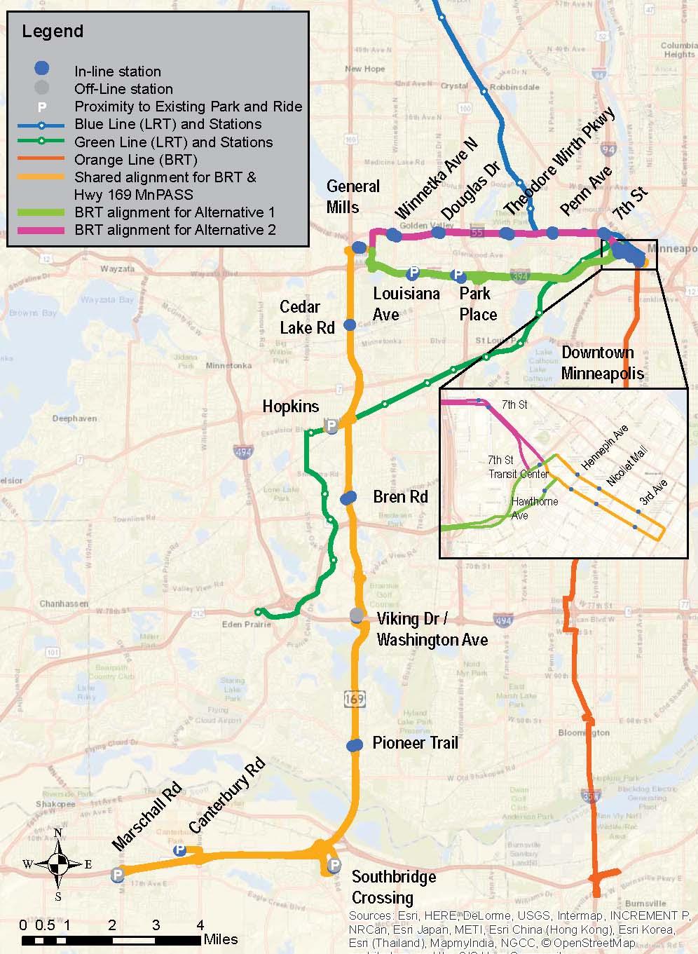


9 Alternatives MnPASS 9
10 Task 1: Competed Work Initial alternative identification & screening 7 initial BRT alternatives screened Hwy. 169 North Analysis (Hwy Brooklyn Blvd.) 11 initial MnPASS alternatives screened (7 termini and 4 cross section options) Final alternatives moving into detailed concept development and evaluation BRT: Marschall Rd. - downtown Mpls. via Hwy. 169/I-394 BRT: Marschall Rd. - downtown Mpls. via Hwy. 169/Hwy. 55 MnPASS: Marschall Rd. I-394 MnPASS: Marschall Rd. Hwy. 55 MnPASS: Marschall Rd. I

11 Task 1: Completed Work BRT Alternatives I-394 alternative 12 stations Hwy. 55 alternative 15 stations 18-hr/day service, seven days per week min. frequency depending on time of day Mostly right shoulder running 11
12 Task 1: Completed Work MnPASS Alternatives Marschall Rd. I-394; Marschall Rd. Hwy. 55; Marschall Rd. I- 494 Added inside lane in each direction w/current MnPASS concept of operations South of Hwy. 62: Mostly standard MnPASS lane design w/widening to the inside North of Hwy. 62: Mostly minimum MnPASS lane design w/widening to the outside Multiple concept design options being evaluated at certain locations (e.g. I-394, Hwy. 55, Cedar Lake Rd., Excelsior Blvd., I- 494, Bloomington Ferry Bridge) Detailed evaluation of alternatives Some spot mobility improvements 12
13 Marschall Rd to I
14 I-494 to TH 62 14
15 North of TH 62 15
16 I-394 to TH 55 16
17 Project Goals Goal 1 Goal 2 Goal 3 Goal 4 Goal 5 Goal 6 Improve Access Current Population Current Employment Travel Time Reliability Employment Centers Mobility Ridership Return on Investment Peak-Hour Congestion Delay Per User Vehicle Hours Traveled Crash Risk Factor Reduction Supportive Conditions BRT Ridership Capital Costs Multi-Modal Policies Transit-Dependent Ridership Reverse-Commute Ridership Off-Peak Ridership SW Transit Routes Shift Total Corridor Ridership Operations and Maintenance Costs Cost per Reliable Trip Cost Effectiveness O&M factors Bicycle and Pedestrian Connections Forecast Population Forecast Employment Preserve Environment Natural Environment Built Environment 17


18 Goal 1 Improve Access Improve access to local and regional destinations, activity centers, and employment concentration Measure Alternative 1: I-394 Alternative 2: TH 55 Current Population 16,300 21,900 Current Employment 38,100 32,800 Travel Time Reliability (Peak Period Trips) Employment Centers 28,100 28,100 Regional Large Medium Small Alternative 2 has 5,600 more residents and Alternative 1 has 5,300 more jobs within ½ mile of station areas Alternative 2 serves more employment centers 18
19 Goal 2 Mobility Provide better mobility in the corridor and options to lessen congestion Measure Alternative 1: I-394 Alternative 2: TH 55 Person throughput 12,300-13,400 12,400-13,600 Delay per user 0:30 to 6:10 (-60%) 0:30 to 6:10 (-60%) Change in VHT -5,500-5,500 Reduction in crash risk -44% congestion (mi-hr) -35% bottleneck conflicts -44% congestion (mi-hr) -35% bottleneck conflicts MnPASS improvements are effective in achieving the mobility goal and associated measures: Increased person throughput along corridor Meaningful reductions in delay Reduction in VHT (important for benefit-cost) Improvement to bottlenecks and congestion 19
20 Goal 3 Ridership Improve the attractiveness of transit to serve more people in the corridor Measure Alternative 1: I-394 Alternative 2: TH 55 Station-to-Station BRT 7,400 6,600 Transit-Dependent 2,000 2,400 Reverse Commute 2,800 3,600 Off-Peak 3,100 2,700 Express Bus 1,000 1,000 Guideway Total 8,400 7,600 Express Bus Routes w/ potential to use 169 2,500 2,500 20
21 Goal 4 Return on Investment Provide a high long-term return on the transportation investment Measure Alternative 1: I-394 Alternative 2: TH 55 Overall Capital Costs $658 million $660 million BRT Capital Cost $67 million $69.0 million BRT Operating & Maint Costs $16.5 million $17.1 million Annualized Capital + Operating Costs per Trip (BRT only) $8.85 $10.25 MnPASS Capital Cost $591 million $591 million Cost per Reliable Trip $4.05 $4.05 Alternative 1 is slightly more cost effective for BRT. 21
22 Results Summary Goal Alternative 1: I-394 Alternative 2: TH Improve Access 2. Mobility 3. Ridership 4. Return on Investment 5. Supportive Conditions 6. Preserve Environment Does not satisfy goal Satisfies goal Best satisfies goal 22
")

23 Alternative 3 MnPASS lanes on Hwy 169 between Marschall Road and I-494 No BRT component or other additional transit service Limited ability to compare directly to BRT Alternatives (1&2) Potential to consider for phasing within Implementation Plan? MnPASS lanes between Marschall Road and I-494 perform sufficiently to merit consideration as a separate phase in the Implementation Plan 23
24 Goal 1 - Access Measure Alternatives 1 & 2 Alternative 3 Travel Time Reliability (Peak Period Trips) 28,100 23,300 Approximately 20% fewer reliable trips compared to Alternatives 1 & 2 24
25 Goal 2 Mobility Measure Alternative 1 & 2 Alternative 3 Person throughput 12,300-13,400 10,100-13,100 Delay per user 0:30 to 6:10 (-60%) 0:40 to 7:50 (-37%) Change in VHT -5,500-2,200 Reduction in crash risk -44% congestion (mi-hr) -35% bottleneck conflicts -23% congestion (mi-hr) -4% bottleneck conflicts Effective at improving throughput and reducing delay along Hwy 169 south of I
26 Goal 4 Return on Investment Measure Alternatives 1 & 2 Alternative 3 Overall Capital Costs $ million $136 million BRT Operating & Maint Costs Annualized Capital + Operating Costs per Trip (BRT only) $16,500,000- $17,100,000 $8.85-$ MnPASS Capital Cost $591 million $136 million Cost per Reliable Trip $4.05 $1.11 Lower cost commitments for MnPASS operations & enforcement and incident management - 26
27 Task 1: Study Outcomes Study results will be incorporated into the Met Council s 2040 Transportation Policy Plan Update The recommended implementation plan of improvements will be used by MnDOT and corridor partners to help determine whether to: Advance specific improvements into project scoping and the environmental/pre-design process; Add specific improvements to projects already programmed or planned within the corridor; and Otherwise get improvements ready should additional funding become available. 27
28 Task 1: Next Steps Finalize spot mobility improvements Complete Sensitivity Tests Optional: Choose Optimized Scenario Develop implementation plan Complete public involvement (Share Alternatives) Final Report 28
29 Sensitivity Tests Peak period frequency reduction BRT without MnPASS Station removal 29
30 Questions? Thank you! Brad Larsen MnPASS Policy & Planning Lisa Freese Scott County Cole Hiniker Metropolitan Council
Title. Metropolitan Council Transportation Committee December 12, Brad Larson Metro District MnDOT
 Title Metropolitan Council Transportation Committee December 12, 2016 Evaluating the potential for Bus Rapid Transit and MnPASS Express Lanes in the southwest Metro Brad Larson Metro District MnDOT Background
Highway 169 Mobility Study Technical Advisory Committee Meeting #9 Meeting Record
 Highway 169 Mobility Study Technical Advisory Committee Meeting #9 Meeting Record Thursday, May 25, 2017 8:30-10:30 a.m. City of Eden Prairie Heritage Rooms I and II Attendees Brad Larsen, MnDOT Angie
Highway 169 Mobility Study Policy Advisory Committee Meeting #5 Meeting Record
 Highway 169 Mobility Study Policy Advisory Committee Meeting #5 Meeting Record Thursday June 22, 2017 3:30 5:30 p.m. Bloomington Public Works Public Works Training Room 1700 West 98th Street, Bloomington,
Enhancing Return on Investment for MnPASS Express Lanes
 Enhancing Return on Investment for MnPASS Express Lanes Minnesota s Transportation Conference February 28, 2018 mnpass.org Agenda MnPASS Express Lane Background MnPASS System Update Enhancing Return on
Highway 169 Mobility Study Policy Advisory Committee Meeting #4 Meeting Record
 Highway 169 Mobility Study Policy Advisory Committee Meeting #4 Meeting Record Wednesday April 5, 2017 3:30 5:30 p.m. Scott County Government Center County Board Room, 2nd Floor 200 4th Ave W, Shakopee,
Highway Transitway Corridor Study
 Highway Transitway Corridor Study CTS Research Conference May 21, 2014 1 2030 Transportation Policy Plan Transitway modes on highways: Highway bus rapid transit (BRT), plan identified 6 total Highway BRT
Bus Rapid Transit Plans
 Twin Cities Region Bus Rapid Transit Plans ULI Minnesota Workshop Connecting Bus Rapid Transit to the Community December 15, 2009 John Levin Director of Service Development Metro Transit Metropolitan Area
Arterial Transitway Corridors Study. Ave
 Arterial Transitway Corridors Study Ave January 2012 Arterial Transitway Corridors Study Overview Corridor Features and Demographics 11 study corridors, 95 route miles 86,000 daily rides and half of existing
MnPASS System Today and the Future
 MnPASS System Today and the Future April 2010 By Nick Thompson Minnesota Department of Transportation Topics Minnesota s Current and Future MnPASS High Occupancy Toll Systems Overview of the MnPASS System
Corridor Advisory Group and Task Force Meeting #10. July 27, 2011
 Corridor Advisory Group and Task Force Meeting #10 July 27, 2011 1 Agenda Recap CAG/TF #9 Public Meeting #2 Summary Single Mode Alternatives Evaluation Results Next Steps 2 3 CAG/TF #9 Recap CAG /TF #9
Cedar Avenue Transitway/ METRO Red Line Implementation Plan Update. Metropolitan Transportation Committee July 27, 2015
 Cedar Avenue Transitway/ METRO Red Line Implementation Plan Update Metropolitan Transportation Committee July 27, 2015 Purpose of Cedar Avenue Transitway Previous IPU August 2011 Review current transit
Arterial Transitway Corridors Study
 Arterial Transitway Corridors Study February 2012 Arterial Transitway Corridors Study Overview Corridor Features and Demographics 11 study corridors, 95 route miles Routes: 86,000 daily rides and half
Eliminate on-street parking where it will allow for a dedicated bus only lane %
 Traffic Dashboard Priorities Survey Responses Introduction 1) Are you familiar with bus rapid transit (BRT)? a. No, BRT is new to me. 597 23.5% b. I ve heard of BRT, but I don t know much about it. 1,136
Metropolitan Council Transportation Committee
 Nicollet-Central Transit Alternatives Metropolitan Council Transportation Committee August 2013 Project Purpose (approved by Policy Advisory Committee 10/25/2012) The purpose is to improve transit connectivity,
Bus Rapid Transit ALTERNATIVES ANALYSIS. Open House
 Bus Rapid Transit ALTERNATIVES ANALYSIS Open House June 23, 2015 Open House Meeting Agenda Agenda Introductions What is BRT? Project Goals Study Tasks Next steps Discussion PVTA Bus Rapid Transit Study
Purpose and Need. Chapter Introduction. 2.2 Project Purpose and Need Project Purpose Project Need
 Chapter 2 Purpose and Need 2.1 Introduction The El Camino Real Bus Rapid Transit (BRT) Project (Project) would make transit and other transportation improvements along a 17.6-mile segment of the El Camino
Community Task Force July 25, 2017
 Community Task Force July 25, 2017 Welcome and Introductions Project Partners Regional Transportation District (RTD) Colorado Department of Transportation (CDOT) Denver Regional Council of Governments
Spring Lake Park Mounds View North Oaks. Arden Hills. Shoreview. Roseville. Little Canada. Falcon Heights SNELLING. Lilydale. West Saint Paul 35E
 Coon Rapids Blaine Spring Lake Park Mounds View rth Oaks In 2011, Metro Transit embarked on the Arterial 494 Minnetonka Maple Grove Plymouth Hopkins Brooklyn Park New Hope Golden Valley Louis Park Edina
Highway Transitway Corridor Study
 Highway Transitway Corridor Study Highway 55: Final Report Addendum Prepared for: Metropolitan Council February 2015 SRF No. 7994 Table of Contents Why were these corridors selected for the study?...
Afeasibility study to evaluate bus rapid transit service in the East-West Corridor connecting major employment and activity centers between downtown
 East-West Bus Rapid Transit Feasibility Study Update and Recommended Locally Preferred Alternative (LPA) Summary City of Wauwatosa, Transportation Affairs Committee June 2016 Afeasibility study to evaluate
Highway Transitway Corridor Study
 Highway Transitway Corridor Study Final Report Prepared for: Metropolitan Council May 2014 SRF No. 7994 Prepared for: Metropolitan Council SRF Consulting Group, Inc. Table of Contents Introduction... 1
ROUTES 55 / 42 / 676 BUS RAPID TRANSIT LOCALLY PREFERRED ALTERNATIVE
 ROUTES 55 / 42 / 676 BUS RAPID TRANSIT LOCALLY PREFERRED ALTERNATIVE April, 2012 1 INTRODUCTION The need for transit service improvements in the Routes 42/55/676 corridor was identified during the Southern
Arterial Transitway Corridors Study. Sept. 26, 2011
 Arterial Transitway Corridors Study Sept. 26, 2011 Purpose of Study Study 11 urban corridors in Minneapolis, St. Paul and surrounding communities Develop service and facilities plan to improve Transit
State Road 54/56 Tampa Bay s Northern Loop. The Managed Lane Solution Linking I-75 to the Suncoast Parkway
 State Road 54/56 Tampa Bay s Northern Loop The Managed Lane Solution Linking I-75 to the Suncoast Parkway SUNCOAST PARKWAY Both I 75 and the Suncoast Parkway are planning, or in the process of constructing,
I-105 Corridor Sustainability Study (CSS)
") I-105 Corridor Sustainability Study (CSS) Metro Streets and Freeways Subcommittee March 21, 2019 Gary Hamrick Cambridge Systematics, Inc. I-105 CSS Project History & Background Funded by Caltrans Sustainable
I-105 Corridor Sustainability Study (CSS) Metro Streets and Freeways Subcommittee March 21, 2019 Gary Hamrick Cambridge Systematics, Inc. I-105 CSS Project History & Background Funded by Caltrans Sustainable
ALTERNATIVES ANALYSIS EXECUTIVE SUMMARY
 West Valley Connector Corridor ALTERNATIVES ANALYSIS EXECUTIVE SUMMARY FINAL September 2014 Ontario International Airport Ontario Mills Rancho Cucamonga Metrolink Station Kaiser Permanente PARSONS EXECUTIVE
ACTION TRANSMITTAL No
 Transportation Advisory Board of the Metropolitan Council of the Twin Cities ACTION TRANSMITTAL No. 2016-15 DATE: January 14, 2016 TO: TAC Planning Committee PREPARED BY: Steven Elmer (651) 602-1756 SUBJECT:
ITS-NY ANNUAL MEETING Bus Rapid Transit in New York City: Bus Lane Operations on One-Way Arterial Streets
 ITS-NY ANNUAL MEETING Bus Rapid Transit in New York City: Bus Lane Operations on One-Way Arterial Streets June 9, 2011 Ted Orosz AICP, Director Long Range Bus Planning MTA New York City Transit 1 Overview
Moving Cambridge. City of Cambridge Transportation Master Plan Public Consultation Centre. March 7, :00 8:00 PM.
 City of Cambridge Transportation Master Plan Public Consultation Centre March 7, 2018 5:00 8:00 PM Region of Waterloo City of Cambridge Transportation Master Plan Public Consultation Centre March 7, 2018
Southwest Bus Rapid Transit (SW BRT) Functional Planning Study - Executive Summary January 19 LPT ATTACHMENT 2.
 Functional Planning Study - Executive Summary January 19 LPT ATTACHMENT 2.") Southwest Bus Rapid Transit (SW BRT) Functional Planning Study - Executive Summary 2011 January 19 1 of 19 Introduction This executive summary presents the results of the Southwest Bus Rapid Transit (SW
Southwest Bus Rapid Transit (SW BRT) Functional Planning Study - Executive Summary 2011 January 19 1 of 19 Introduction This executive summary presents the results of the Southwest Bus Rapid Transit (SW
Midtown Corridor Alternatives Analysis
 Midtown Corridor Alternatives Analysis Ridership Forecast Methodology and Results December 2013 Prepared by the SRF Consulting Group Team for Table of Contents Introduction... 1 Methodology... 1 Assumptions...
Chapter 7. Transportation. Transportation Road Network Plan Transit Cyclists Pedestrians Multi-Use and Equestrian Trails
 Chapter 7 Transportation Transportation Road Network Plan Transit Cyclists Pedestrians Multi-Use and Equestrian Trails 7.1 TRANSPORTATION BACKGROUND The District of Maple Ridge faces a number of unique
Typical Rush Hour Commute. PennyforTransportation.com
 Typical Rush Hour Commute In the News Overview of the Plan Collaborative plan with projects in every community Prioritizing connectivity and congestion relief Dedicated transportation-specific funding;
Priced Managed Lanes in America. October 2013
 Priced Managed Lanes in America October 2013 1 Priced Managed Lanes What are they? Where are they? Why do them? When to do them? Common issues Lessons learned What are Priced Managed Lanes? The subset
North Coast Corridor:
 North Coast Corridor: Connecting People, Transportation & Environment Legislative Hearing: 11.8.10 1 North Coast Corridor Region s Lifeline A Regional Strategy Mobility, Economy & Environment North Coast
York Region Population and Employment Growth
 March 1, 2016 1 York Region Population and Employment Growth York Region needs to comply with The Provincial Growth Plan and new forecasts introduced to 2036 and 2041 2 Regional Official Plan Review York
Linking Land Use & Transportation in Minneapolis
 CITY OF MINNEAPOLIS Linking Land Use & Transportation in Minneapolis Presentation to All Transportation is Local Council President Lisa Bender March 22, 2018 1 Overview Minneapolis and the Twin Cities
Scottsdale Road/Rural Road Alternatives Analysis (AA) Study. Arizona ITE/IMSA Spring Conference March 7, 2012
 Study. Arizona ITE/IMSA Spring Conference March 7, 2012") Scottsdale Road/Rural Road Alternatives Analysis (AA) Study Arizona ITE/IMSA Spring Conference March 7, 2012 Study Location and Duration Primary Study Corridor (major focus of effort) Rural Road and Scottsdale
Scottsdale Road/Rural Road Alternatives Analysis (AA) Study Arizona ITE/IMSA Spring Conference March 7, 2012 Study Location and Duration Primary Study Corridor (major focus of effort) Rural Road and Scottsdale
Transportation Master Plan Advisory Task Force
 Transportation Master Plan Advisory Task Force Network Alternatives & Phasing Strategy February 2016 BACKGROUND Table of Contents BACKGROUND Purpose & Introduction 2 Linking the TMP to Key Council Approved
North Shore Transportation Improvement Strategy
 North Shore Transportation Improvement Strategy Preliminary, Near-term Recommendation 2016 April Transportation Improvement Strategy (TIS) Comprehensive and Analytical A multi-modal transportation strategy
Calgary Transit Route 302 Southeast BRT Year One Review June
 Calgary Transit Route 302 Southeast BRT Year One Review 2011 June Calgary Transit Route 302 Southeast BRT: Year One Review 2011 April Table of Contents 1.0 Executive Summary... 1 2.0 Introduction... 3
11,000. P.M. Peak Hour Vehicles/Hour 10,000 9,000 8,000. Year
 CONGESTION RELIEF TASK FORCE The problem today With traffic levels hampering downtown circulation, and long delays in west Salem, policy makers are evaluating potential transportation infrastructure, programs,
Preliminary Transportation Analysis
 Preliminary Transportation Analysis Goals of a Robust, Multimodal Transportation Network Safe Accessible/Connected Efficient Comfortable Context-Sensitive Motor Vehicle: Continue to analyze the data to
Highway 17 Transportation Improvement Study
 Final Report Highway 17 Transportation Improvement Study prepared for Santa Cruz County Regional Transportation Commission (SCCRTC) prepared by Planning and Engineering, Inc. 1155 North First Street, Suite
Highway 217 Corridor Study. Phase I Overview Report
 Highway 217 Corridor Study Phase I Overview Report November 3, 24 BACKGROUND AND OVERVIEW Study purpose The Highway 217 Corridor Study is developing multi-modal transportation solutions for traffic problems
Public Information Meeting
 Richmond Highway (U.S. Route 1) Corridor Improvements Public Information Meeting Tuesday, April 18, 2017 Mount Vernon High School 8515 Old Mt. Vernon Road, Alexandria, VA 22309 Amanda Baxter, VDOT, Special
Hennepin/First Transportation Study
 CITY OF MINNEAPOLIS Hennepin/First Transportation Study NIEBNA Board Meeting November 10, 2016 11/10/2016 1 Study Overview Evaluate transportation system and alternatives Coordinate with County, Metro
Corridor Vision Workshop Summary James Madison Elementary February 22,2018
 Corridor Vision Workshop Summary James Madison Elementary February 22,2018 WHY DEVELOP THIS STUDY? Ogden City is planning for better connectivity and access to jobs and housing. Working with area partners,
MCTC 2018 RTP SCS and Madera County RIFP Multi-Modal Project Eval Criteria GV13.xlsx
 MCTC 8 RTP SCS and Madera County RIFP Multi-Modal Project Eval Criteria GV.xlsx Madera County Transportation Commission Regional Transportation Plan / Sustainable Communities Strategy Multi-Modal Project
WHITE PAPER: TRANSIT SERVICE FOR SOUTH SHAGANAPPI
 9/27/2012 TRANSIT PLANNING WHITE PAPER: TRANSIT SERVICE FOR SOUTH SHAGANAPPI 2012 Calgary Transit 1 Table of Contents Purpose... 3 Area of Change... 3 Background... 3 Access to destinations... 5 Connecting
Wilshire Boulevard Bus Rapid Transit Project
 Los Angeles County Metropolitan Transportation Authority Wilshire Boulevard Bus Rapid Transit Project COMMUNITY MEETINGS November 2008 Agenda Introduction Proposed Project Overview Participating Agencies
Durham Region Long Term Transit Strategy
 Durham Region Long Term Transit Strategy An adaptive, safe, reliable, frequent, accessible and desirable transit system that shapes and connects Durham Region and beyond in an economically and environmentally
EL CAMINO REAL BUS RAPID TRANSIT (BRT) PROJECT
 PROJECT") Agenda Item #4.2 EL CAMINO REAL BUS RAPID TRANSIT (BRT) PROJECT VTA BOARD WORKSHOP MAY 1, 2015 ABOUT THIS PRESENTATION CONTEXT Existing conditions and planning for growth WHAT IS THE PROJECT? Project alternatives
Agenda Item #4.2 EL CAMINO REAL BUS RAPID TRANSIT (BRT) PROJECT VTA BOARD WORKSHOP MAY 1, 2015 ABOUT THIS PRESENTATION CONTEXT Existing conditions and planning for growth WHAT IS THE PROJECT? Project alternatives
Regional Transportation Needs Within Southeastern Wisconsin
 Regional Transportation Needs Within Southeastern Wisconsin #118274 May 24, 2006 1 Introduction The Southeastern Wisconsin Regional Planning Commission (SEWRPC) is the official areawide planning agency
Managed Lanes: A National Perspective Managed Lane Strategies
 Managed Lanes: A National Perspective Managed Lane Strategies Use the following control strategies to manage a lane(s) to provide a reliable transportation option: Eligibility/occupancy Access control
I-66 Corridor Improvements Route 15 to I-495. November 2014
 I-66 Corridor Improvements Route 15 to I-495 November 2014 I-66 Corridor: Haymarket to the Beltway = Park and Ride Lots 2 Purpose and Need Improve multimodal mobility along the I-66 corridor by providing
Presentation of Staff Draft March 18, 2013 COUNTYWIDE TRANSIT CORRIDORS FUNCTIONAL MASTER PLAN
 Presentation of Staff Draft March 18, 2013 COUNTYWIDE TRANSIT CORRIDORS FUNCTIONAL MASTER PLAN Public Outreach Fall 2011: Two community meetings/open houses Fall 2012: Three community meetings/open houses
Westside Transportation Access Needs Assessment - Short and Long Term Improvements
 ABSTRACT The Los Angeles County Metropolitan Transportation Authority (MTA) adopted the 2001 Long Range Transportation Plan (LRTP), which sets out the County s transportation investments for the next 20-25
Task Force Meeting #5, August 3, Prepared by DKS Associates
 Task Force Meeting #5, August 3, 2018 Prepared by DKS Associates Agenda 1. Agenda Review and Meeting #4 Recap 2. Review Project Goal, Data, and Project Ideas 3. Recommendations and Reporting a) Recommended
Tulsa Metropolitan Area LONG RANGE TRANSPORTATION PLAN
 Tulsa Metropolitan Area LONG RANGE TRANSPORTATION PLAN Indian Nations Council of Governments August 2005 CONTACTING INCOG In developing the Destination 2030 Long Range Transportation Plan, INCOG s Transportation
4 Ridership Growth Study
 Clause 4 in Report No. 15 of Committee of the Whole was adopted, without amendment, by the Council of The Regional Municipality of York at its meeting held on November 16, 2017. 4 Ridership Growth Study
2. Context. Existing framework. The context. The challenge. Transport Strategy
 Transport Strategy Providing quality connections Contents 1. Introduction 2. Context 3. Long-term direction 4. Three-year priorities 5. Strategy tree Wellington City Council July 2006 1. Introduction Wellington
Bottineau Transitway Health Impact Assessment Summary
 December 2013 Hennepin County Bottineau Transitway Health Impact Assessment Summary Prepared by Crystal Myslajek Overview of the Bottineau Transitway The Bottineau Transitway (METRO Blue Line extension)
PURPOSE AND NEED SUMMARY 54% Corridor Need 1. Corridor Need 2. Corridor Need 3. Corridor Need 4. Corridor Need 5
 SUMMARY PURPOSE AND NEED Chapel Hill Transit ridership has increased Buses operate every 4 minutes and have standing room only Exceeding seated capacity by 12% Corridor Need 1 by more than 20 percent between
Washington DC Section of ITE Project Briefing
 Washington DC Section of ITE Project Briefing November 5, 2015 Renée Hamilton, VDOT, Deputy District Administrator I-66 Outside the Beltway Improvement Area Project Location Virginia 2 Purpose and Need
Evaluation of Alternatives and Final Screening Results November 20 and 21, 2013
 Midtown Corridor Alternatives ti Analysis Evaluation of Alternatives and Final Screening Results November 20 and 21, 2013 Today s Agenda Alternatives background Process update Key evaluation factors cost
Seattle Transit Master Plan
 Seattle Transit Master Plan Seattle City Council Transportation Committee Briefing July 26, 2011 Seattle Department of Transportation In Association with: URS Corporation SVR DKS Associates The Underhill
WELCOME BUS RAPID TRANSIT PUBLIC MEETING. MEETING TIME: 5 p.m. - 8 p.m.
 WELCOME BUS RAPID TRANSIT PUBLIC MEETING MEETING TIME: 5 p.m. - 8 p.m. Milwaukee County in conjunction with the Federal Transit Administration is hosting today s meeting to give the public an opportunity
Arlington County 10-Year Transit Development Plan & Premium Transit Network Briefing. May 2016
 Arlington County 10-Year Transit Development Plan & Premium Transit Network Briefing May 2016 Overview 10-Year Transit Development Plan Premium Transit Network Columbia Pike service concept Premium amenities
Craig Rempp, Transit Superintendent Mary Karlsson, Kimley-Horn. Mankato City Council Meeting 6/25/2018
 Craig Rempp, Transit Superintendent Mary Karlsson, Kimley-Horn Mankato City Council Meeting 6/25/2018 What is a Transit Development Plan (TDP)? Engagement Issues Goals, objectives, design guidelines and
DULLES AREA TRANSPORTATION ASSOCIATION (DATA) February 18, Susan Shaw, P.E., VDOT, Megaprojects Director
 February 18, Susan Shaw, P.E., VDOT, Megaprojects Director") DULLES AREA TRANSPORTATION ASSOCIATION (DATA) February 18, 2015 Susan Shaw, P.E., VDOT, Megaprojects Director I-66 Corridor Conditions Steady population growth Employment growth in activity centers Congestion
DULLES AREA TRANSPORTATION ASSOCIATION (DATA) February 18, 2015 Susan Shaw, P.E., VDOT, Megaprojects Director I-66 Corridor Conditions Steady population growth Employment growth in activity centers Congestion
VISION Long Range Plan Update Board Workshop. February 10, 2016
 VISION 2040 Long Range Plan Update Board Workshop February 10, 2016 Vision 2040 Key Milestones UNDERSTAND THE NEED IDENTIFY A RANGE OF OPTIONS EVALUATE COMMUNITY OPTIONS DEFINE PROJECTS & PLANS Vision
Today s Agenda. Welcome & Introductions. I-526 Lowcountry Corridor Update. Table Discussions. Next Steps / Conclusion
 SCDOT Turns 100! SCDOT Turns 100! Today s Agenda Welcome & Introductions I-526 Lowcountry Corridor Update Table Discussions Next Steps / Conclusion Project Limits I-526 Lowcountry Corridor Project Description
Speaker: Brian Dranzik, Fiscal & Policy Administrator Milwaukee County
 Milwaukee County Speaker: Brian Dranzik, Fiscal & Policy Administrator Milwaukee County Department of Transportation and Public Works Project coordinated by Milwaukee County Transit System and Southeastern
FY Transportation Capital Improvement Plan Update Arlington Committee for Transportation Choices
 FY 2017-2026 Transportation Capital Improvement Plan Update Arlington Committee for Transportation Choices November 1, 2017 Forecasted Growth Arlington continues to grow with a shift towards multi-family
Governor s Transportation Vision Panel
 Office of Governor Kate Brown Governor s Transportation Vision Panel JLA Public Involvement Project Overview The is a yearlong effort to develop a series of recommendations for the Governor that address
El Camino Real Bus Rapid Transit Conceptual Engineering. Los Altos Council Workshop January 24, 2012
 El Camino Real Bus Rapid Transit Conceptual Engineering Los Altos Council Workshop January 24, 2012 Agenda Introduction Growth in the El Camino Real Corridor Benefits of BRT El Camino Real BRT Decision
Benefits for the Bronx, Brooklyn, Queens and Staten Island
 Congestion Pricing for New York: Benefits for the Bronx, Brooklyn, and Staten Island Prepared for the Coalition for Traffic Relief April 007 Schaller Consulting 94 Windsor Place, Brooklyn, NY (78) 768-3487
Interstate 66 Tier 1 Environmental Impact Statement. Cooperating and Participating Agencies Meeting March 19, 2012
 Interstate 66 Tier 1 Environmental Impact Statement Cooperating and Participating Agencies Meeting March 19, 2012 Chris Collins Virginia Department of Transportation, Environmental Division Meeting Agenda
Multi Modal Transit Access Plan KIPDA ID # 239. Project Type: STUDY
 Multi Modal Transit Access Plan KIPDA ID # 239 Project Type: STUDY Description: In conjunction with the results from Project Gobility and the Transit LOS Analysis, TARC seeks to examine the possibilities
Community Task Force March 14, 2018
 Community Task Force March 14, 2018 Welcome and Introductions Project Partners Regional Transportation District (RTD) City of Aurora Colorado Department of Transportation (CDOT) Denver Regional Council
Short-Term Enhancements Improvements to keep Austin moving. MetroRapid
 Short-Term Enhancements Improvements to keep Austin moving Long-Term Investments Projects to support our future Mobility Hubs MetroRapid MetroRail MetroExpress Commuters Connectors Circulators Project
Congestion Reducing Activities. Toby Carr GDOT Director of Planning April 10, 2014
 Congestion Reducing Activities Toby Carr GDOT Director of Planning April 10, 2014 GDOT Performance Dashboard Congestion Congestion Relief Strategies 511 HEROS RTOP Highway Emergency Response Operators
Standing Committee on Policy and Strategic Priorities
 POLICY REPORT Report Date: January 15, 2019 Contact: Steve Brown Contact No.: 604.873.9733 RTS No.: 12955 VanRIMS No.: 08-2000-20 Meeting Date: January 30, 2019 TO: FROM: SUBJECT: Standing Committee on
DES MOINES AREA MPO. Presentation to Iowa Commercial Real Estate Association. April 6, 2017
 DES MOINES AREA MPO Presentation to Iowa Commercial Real Estate Association April 6, 2017 Presentation Outline MPO Overview Trends We re Watching Plans, Projects, Initiatives, Regional Transportation Priorities
Goal 3: Foster an environment of partnerships and collaboration to connect our communities and regions to one another.
 Non-Motorized Transportation Plan (NMTP) Draft Vision, Goal and,, Tri-County Regional Planning Commission (TCRPC) Purpose The purpose of the Tri-County Regional Planning Commission (TCRPC) Non-Motorized
Metropolitan Council Transportation Committee. Twin Cities Regional Bicycle Barriers Study
 Metropolitan Council Transportation Committee Twin Cities Regional Bicycle Barriers Study June 27, 2016 Study Background Regional Bicycle Transportation Network Established in 2040 Transportation Policy
UPDATING THE WEST COUNTY ACTION PLAN
 UPDATING THE WEST COUNTY ACTION PLAN Presentation to the WCCTAC Technical Advisory Committee Presented By: In Association With: DKS CH2M HILL Dyett & Bhatia Eisen Letunic February 14, 2013 The Consultant
Providing an Efficient and Multi-modal Transportation System
 Providing an Efficient and Multi-modal Transportation System Welcome and Introductions The Plan Process Transportation Overview Workshop Discussions Report Out and Next Steps AGENDA Comprehensive Plan
WELCOME TO OPEN HOUSE # 1 June 14, 2017
 Langstaff Road Weston Road to Highway 7 Class Environmental Assessment Study WELCOME TO OPEN HOUSE # 1 June 14, 2017 Please sign in and join our mailing list Purpose of Open House #1 & Study Area York
Transit Operations in the I-95 Express Lanes
 Transit Operations in the I-95 Express Lanes TRB 15 th International Conference on Managed Lanes Miami, Florida Presented by Diane Quigley FDOT Transit Planning Administrator May 5, 2016 FDOT Governance
Everett Transit Action Plan. Community Open House November 16, 2015
 Everett Transit Action Plan Community Open House Everett has a great location, but getting around the city and into surrounding communities is a problem for all ages Many Voices, One Future: The Everett
Welcome to the McKenzie Interchange Project Open House!
 Welcome to the McKenzie Interchange Project Open House! Purpose of Open House To provide you with information regarding the project and for you to have the opportunity to share your input on design concepts.
Town of Superior. Superior Trails Plan
 Part 1 Base Information 1. Project Title US 36 Bikeway Extension 2. Project Start/End points or Geographic Area Provide a map with submittal, as appropriate 3. Project Sponsor (entity that will construct/
Bus Rapid Transit on Silicon Valley s El Camino Real: Working Together to Create a Grand Boulevard Steven Fisher
 Bus Rapid Transit on Silicon Valley s El Camino Real: Working Together to Create a Grand Boulevard Steven Fisher Senior Transportation Planner Santa Clara Valley Transportation Authority San Jose, CA How
POLICY ADVISORY COMMITTEE
 September 27, 2018 POLICY ADVISORY COMMITTEE ENVIRONMENTAL ANALYSIS PHASE Agenda 1. Welcome and introductions. 2. Overview of project activities and process. 3. Public engagement update. 4. Community Advisory
SANTA MONICA BOULEVARD CORRIDOR
 CIRCULATION ELEMENT WHITE PAPER NO. 3 SANTA MONICA BOULEVARD CORRIDOR INTRODUCTION From the 1930s to the beginning of Los Angeles freeway era, Santa Monica Boulevard, (previously Route 66, the Beverly
Project Description Form 6V
 Project Description Form 6V Basic Project Information Submitting Jurisdiction/Agency: Prince William County Project Title: Route 15 Widening: Route 55 to south of RR tracks & Construct RR Overpass Project
Main-McVay Transit Study: Phase 2 Options Definition and High Level Constraints Evaluation
 Main-McVay Transit Study: Phase 2 Options Definition and High Level Constraints Evaluation APRIL 2016 A collaborative study between: For Additional Information or to Comment If you would like additional
REDWOOD CITY STREETCAR - ALTERNATIVES ANALYSIS
 REDWOOD CITY STREETCAR - ALTERNATIVES ANALYSIS The purpose of this document is to ennumerate the analysis of alternatives for a streetcar along the Broadway Corriodor of Redwood City. The six alternatives