Traffic Impact Study. Crestline Piggly Wiggly Mountain Brook, Alabama. Goodwyn, Mills and Cawood, Inc. Birmingham, Alabama.
|
|
|
- Roger Lawrence
- 5 years ago
- Views:
Transcription

1 Traffic Impact Study Crestline Piggly Wiggly Mountain Brook, Alabama Prepared for: Goodwyn, Mills and Cawood, Inc. Birmingham, Alabama September 214 Revision 1 October 214
2

3
4
5 Crestline Piggly Wiggly Mountain Brook, Alabama TABLE OF CONTENTS Page Introduction... 1 Background Information... 4 Study Area and Intersections... 4 Study Area Roadways... 4 Existing Intersection Turning Movement Traffic Counts... 6 Historical Traffic Growth... 6 Analysis Existing Intersection Capacity Analysis Background 219 Intersection Capacity Analysis Trip Generation Directional Distribution Traffic Assignment Future 219 Intersection Capacity Analysis Future 219 Turn Lane Warrant Analysis Future 219 Queue Analysis Traffic Impacts of the Proposed Development Delivery Truck Routing Analysis Pedestrian Access and Circulation Analysis Site Circulation Issues APPENDICES Appendix A Appendix B Appendix C Appendix D Appendix E Appendix F Appendix G Site Plan Existing Intersection Turning Movement Traffic Counts Existing Intersection Capacity Analysis Worksheets Background 219 Intersection Capacity Analysis Worksheets Future 219 Intersection Capacity Analysis Worksheets Future 219 Right Turn Lane Warrant Analysis Worksheets Future 219 Intersection Capacity Analysis Worksheets Church Street at Dexter Avenue (Signalized) Skipper Consulting, Inc. Page i
6 Crestline Piggly Wiggly Mountain Brook, Alabama LIST OF ILLUSTRATIONS Figure Page 1 Site Location Map Existing Turning Movement Traffic Volumes A.M. Peak Hour Existing Turning Movement Traffic Volumes Afternoon School Peak Hour Existing Turning Movement Traffic Volumes P.M. Peak Hour Background 219 Turning Movement Traffic Volumes A.M. Peak Hour Background 219 Turning Movement Traffic Volumes Afternoon School Peak Hour Background 219 Turning Movement Traffic Volumes P.M. Peak Hour Directional Distribution Future 219 Turning Movement Traffic Volumes A.M. Peak Hour Future 219 Turning Movement Traffic Volumes Afternoon School Peak Hour Future 219 Turning Movement Traffic Volumes P.M. Peak Hour Truck Turning Templates Dexter Avenue Truck Turning Templates West Jackson Blvd Truck Turning Templates Euclid Avenue Truck Turning Templates Loading Dock Pedestrian System Recommendations Pedestrian Crosswalk Church Street at Dexter Avenue Table 1 Historical Traffic Growth Existing Intersection Capacity Analysis Background 219 Intersection Capacity Analysis Trip Generation Future 219 Intersection Capacity Analysis Future 219 Right Turn Lane Warrant Analysis Future 219 Queue Analysis Future 219 Intersection Capacity Analysis with Improvements Future 219 Microsimulation Model Comparison Skipper Consulting, Inc. Page ii
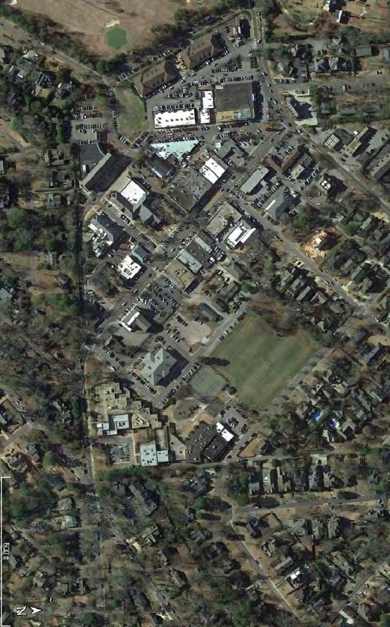
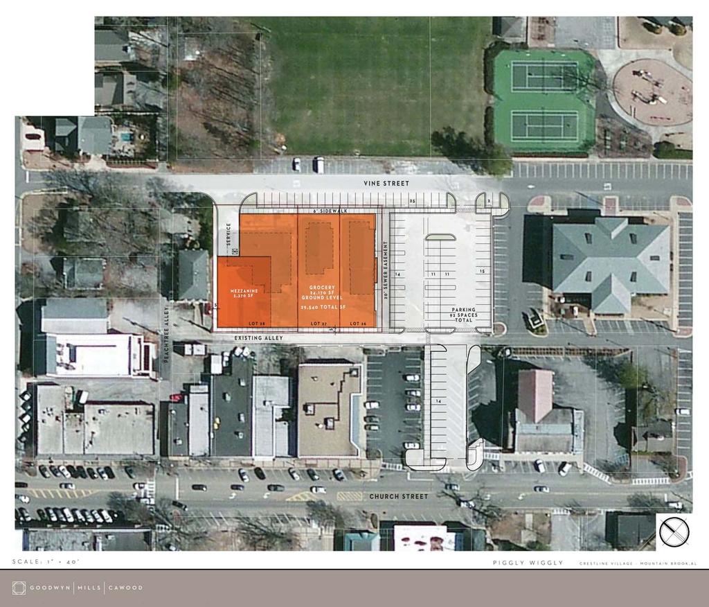
7 Crestline Piggly Wiggly Mountain Brook, Alabama Introduction This report documents a traffic impact study performed for a proposed grocery store to be located on Vine Street between Dexter Avenue and West Jackson Boulevard in Mountain Brook, Alabama. The location of the site with respect to the area roadway network is shown in Figure 1. The proposed development will be constructed in a single phase. The buildout of the site will include a grocery store of approximately 27,932 29,54 square feet of retail space and a Girl Scout meeting facility of 1,76 square feet. The proposed development will occupy land which currently contains a daycare facility, an invitation printing business, a Girl Scout meeting facility, and a vacant lot. For the purposes of this study, an analysis year of 219 was selected. The proposed development is to be accessed by driveways on Vine Street, on the alley between Vine Street and Church Street, and an access to Church Street at the location of an existing access to Regions Bank. The proposed site plan is included in Appendix A. The purposes of this study are to: Analyze the existing traffic conditions on the roadways in the vicinity of the proposed development; Determine the projected growth in traffic to the year 219; Analyze background traffic conditions without the proposed development for 219 conditions on the roadways in the vicinity of the proposed development; Estimate the trip generation of the proposed development; Estimate the directional distribution of traffic generated by the proposed development; Assign site generated traffic to the area roadway network and analyze the resultant traffic operations; Determine whether a right turn lane will be warranted on Church Street at the site access point; Estimate the queue lengths of turning traffic at the intersection of Church Street at the site access with the proposed development in place; Develop recommendations for site access and roadway improvements required to support the proposed development for buildout traffic conditions; Skipper Consulting, Inc. Page 1
8
9 Crestline Piggly Wiggly Mountain Brook, Alabama Analyze truck routes for delivery to the proposed development; Analyze pedestrian routes for the proposed development; and Develop specific site traffic circulation recommendations related to the interrelationship between the proposed development and Crestline Elementary School. Sources of information used in this report included Goodwyn, Mills, and Cawood, Inc., the City of Mountain Brook, Mountain Brook City Schools, the Regional Planning Commission of Greater Birmingham, the Institute of Transportation Engineers, the Transportation Research Board, the National Cooperative Highway Research Program, and office files and field reconnaissance efforts of Skipper Consulting, Inc. Skipper Consulting, Inc. Page 3
10 Crestline Piggly Wiggly Mountain Brook, Alabama Background Information Study Area and Intersections The study area determined for the preparation of the traffic impact study includes the following intersections: Montevallo Road at Church Street/Montrose Road Church Street at West Jackson Boulevard The three driveways on Church Street between Regions Bank and CVS Church Street at Dexter Avenue Dexter Avenue at Vine Street The locations of the study intersections are depicted in Figure 1. Study Area Roadways Montevallo Road. In the vicinity of the site, Montevallo Road is a two lane classified minor arterial roadway with a posted speed limit of 3 miles per hour. The intersection of Montevallo Road at Church Street/Montrose Road is controlled by a traffic signal. Skipper Consulting, Inc. Page 4
11 Crestline Piggly Wiggly Mountain Brook, Alabama Church Street. In the vicinity of the site, Church Street is a three lane local roadway with a posted speed limit of 2 miles per hour. Vine Street. In the vicinity of the site, Vine Street is a two lane local roadway with a posted speed limit of 2 miles per hour. Vine Street is one way westbound from West Jackson Boulevard to Dexter Avenue during the hours of 7:2 a.m. to 4: p.m. to account for traffic operations of Crestline Elementary School. Dexter Avenue. In the vicinity of the site, Dexter Avenue is a two lane local roadway with a posted speed limit of 2 miles per hour. West Jackson Boulevard. In the vicinity of the site, West Jackson Boulevard is a three lane local roadway with no posted speed limit. West Jackson Boulevard is one way northbound from Church Street to Vine Street during the hours of 7:2 a.m. to 4: p.m. to account for traffic operations of Crestline Elementary School. West Jackson Boulevard serves as a primary pick up and drop off area for Crestline Elementary School. Skipper Consulting, Inc. Page 5
12 Crestline Piggly Wiggly Mountain Brook, Alabama Existing Intersection Turning Movement Traffic Counts Existing intersection turning movement traffic counts were performed at the study area intersections on typical weekdays between Wednesday, May 14, 214 and Wednesday, May 21, 214 from 7: to 9: a.m., 2:3 to 3:3 p.m., and 4: to 6: p.m. by Traffic Data, LLC, on behalf of Skipper Consulting, Inc. The existing traffic counts are included in Appendix B. Existing a.m., afternoon school, and p.m. peak hour traffic counts were calculated using the traffic count data included in Appendix B. The existing a.m., afternoon school, and p.m. peak hour traffic volumes are included in Figures 2, 3, and 4. Historical Traffic Growth Existing average daily traffic counts were obtained from the Regional Planning Commission of Greater Birmingham for Montevallo Road in the vicinity of the site for various years between 1987 and An analysis was performed to determine the rate of historical traffic growth on Montevallo Road. The traffic counts and growth analysis are shown in Table 1. For the purposes of projecting background traffic volumes for the year 219, a growth rate of +3.% per year was applied to the existing traffic counts. The background 219 a.m., afternoon school, and p.m. peak hour traffic volumes are included in Figures 5, 6, and 7. Table 1 Historical Traffic Growth Year Daily Traffic Count Per Year Growth , , % ,4 5.8% , % , +.9% Overall Growth : +3.% per year Skipper Consulting, Inc. Page 6
13 Vine Street Dexter Avenue Church Street LEGEND Traffic Volumes Pedestrian Volumes Oak Street Road Montevallo Crestline Piggly Wiggly - Mountain Brook, Alabama 1 Existing Turning Movement Traffic Volumes A.M. Peak Hour Sept 214 Montrose Road North Scale: n.t.s 2 Figure 7
14 Vine Street 3 42 Dexter Avenue Church Street LEGEND Traffic Volumes Pedestrian Volumes Oak Street Road Montevallo Crestline Piggly Wiggly - Mountain Brook, Alabama 5 Existing Turning Movement Traffic Volumes Afternoon School Peak Hour Sept 214 Montrose Road North Scale: n.t.s 3 Figure 8
15 Vine Street Dexter Avenue Church Street LEGEND Traffic Volumes Pedestrian Volumes Oak Street Montevallo Existing Turning Movement Traffic Volumes P.M. Peak Hour Road Crestline Piggly Wiggly - Mountain Brook, Alabama Sept 214 Montrose Road North Scale: n.t.s 4 Figure 9
16 Vine Street Dexter Avenue Church Street LEGEND Traffic Volumes Pedestrian Volumes Oak Street Road Montevallo Crestline Piggly Wiggly - Mountain Brook, Alabama 1 Background 219 Turning Movement Traffic Volumes A.M. Peak Hour Sept 214 Montrose Road North Scale: n.t.s 5 Figure 1
17 Vine Street 3 48 Dexter Avenue Church Street LEGEND Traffic Volumes Pedestrian Volumes Oak Street Road Montevallo Crestline Piggly Wiggly - Mountain Brook, Alabama 5 Background 219 Turning Movement Traffic Volumes Afternoon School Peak Hour Sept 214 Montrose Road North Scale: n.t.s 6 Figure 11
18 Vine Street Dexter Avenue Church Street LEGEND Traffic Volumes Pedestrian Volumes Oak Street Road Montevallo Crestline Piggly Wiggly - Mountain Brook, Alabama Background 219 Turning Movement Traffic Volumes P.M. Peak Hour Sept 214 Montrose Road North Scale: n.t.s 7 Figure 12
19 Crestline Piggly Wiggly Mountain Brook, Alabama Analysis Existing Intersection Capacity Analysis Existing a.m., afternoon school, and p.m. peak hour intersection capacity analyses were performed for the study intersections using the method of analysis included in the 21 Highway Capacity Manual, published by the Transportation Research Board. Capacities are expressed as levels of service, and range from a level of service A (highest quality of service) to a level of service F (jammed conditions). As a general rule, operation at a level of service C or better is desirable, with a level of service D considered acceptable during peak hours of traffic flow. The existing a.m., afternoon school, and p.m. peak hour intersection capacity analysis worksheets are included in Appendix C and are summarized in Table 2. Background 219 Intersection Capacity Analysis Background 219 (without the proposed development) a.m., afternoon school, and p.m. peak hour intersection capacity analyses were performed for the study intersections using the method of analysis included in the 21 Highway Capacity Manual, published by the Transportation Research Board. Capacities are expressed as levels of service, and range from a level of service A (highest quality of service) to a level of service F (jammed conditions). As a general rule, operation at a level of service C or better is desirable, with a level of service D considered acceptable during peak hours of traffic flow. The background 219 a.m., afternoon school, and p.m. peak hour intersection capacity analysis worksheets are included in Appendix D and are summarized in Table 3. Skipper Consulting, Inc. Page 13
20 Crestline Piggly Wiggly Mountain Brook, Alabama Table 2 Existing Intersection Capacity Analysis Level of Service Intersection Approach Movement Aft. AM School PM Left C C C Church Street Eastbound Through Right F D F Overall approach F D F Left C C C Montrose Road Westbound Through Right D D E Overall approach D D E Montevallo Road at Church Street/ Montrose Road Church Street at West Jackson Boulevard Church Street at Regions Bank Church Street at Site Access (Center Driveway) Church Street at CVS Driveway Church Street at Dexter Avenue Dexter Avenue at Vine Street* Montevallo Road Northbound Left F D D Through Right C C E Overall approach F C E Montevallo Road Southbound Left Through Right F D F Overall intersection F D F Church Street Eastbound Left B A A Church Street Westbound Left A A A West Jackson Boulevard Northbound Left Through Right E C C West Jackson Boulevard Southbound Left Through Right n/a n/a D Left D C C Regions Bank Driveway Right B B B Southbound Overall approach C B B Site Access Southbound Left Right A B B Church Street Eastbound Left A A A CVS Driveway Southbound Left Right C C C Church Street Eastbound Left A A A Dexter Avenue Southbound Left Right F E C Vine Street Eastbound Left Through Right B B B Vine Street Westbound Left Through Right B C B Dexter Avenue Northbound Left Through Right A A A Dexter Avenue Southbound Left Through Right A A A * See the detailed discussion concerning the capacity of intersection of Dexter Avenue at Vine Street beginning on page 26 of this report. The actual traffic conditions are not accurately reflected in the results of the capacity analysis. Skipper Consulting, Inc. Page 14
21 Crestline Piggly Wiggly Mountain Brook, Alabama Table 3 Background 219 Intersection Capacity Analysis Level of Service Intersection Approach Movement Aft. AM School PM Left C C C Church Street Eastbound Through Right F E F Overall approach F D F Left C C C Montrose Road Westbound Through Right E E F Overall approach E D E Montevallo Road at Church Street/ Montrose Road Church Street at West Jackson Boulevard Church Street at Regions Bank Church Street at Site Access (Center Driveway) Church Street at CVS Driveway Church Street at Dexter Avenue Dexter Avenue at Vine Street* Montevallo Road Northbound Left F F F Through Right C D F Overall approach F E F Montevallo Road Southbound Left Through Right F F F Overall intersection F F F Church Street Eastbound Left B A A Church Street Westbound Left A A A West Jackson Boulevard Northbound Left Through Right F D C West Jackson Boulevard Southbound Left Through Right n/a n/a E Left D C C Regions Bank Driveway Right B B B Southbound Overall approach C B B Site Access Southbound Left Right A B C Church Street Eastbound Left A A A CVS Driveway Southbound Left Right C C C Church Street Eastbound Left A A A Dexter Avenue Southbound Left Right F F D Vine Street Eastbound Left Through Right B C B Vine Street Westbound Left Through Right B D B Dexter Avenue Northbound Left Through Right A A A Dexter Avenue Southbound Left Through Right A A A * See the detailed discussion concerning the capacity of intersection of Dexter Avenue at Vine Street beginning on page 26 of this report. The projected traffic conditions are not accurately reflected in the results of the capacity analysis. Skipper Consulting, Inc. Page 15
22 Crestline Piggly Wiggly Mountain Brook, Alabama Trip Generation The trip generation of the proposed development for buildout traffic conditions was calculated based on information contained in the Institute of Transportation Engineers publication Trip Generation, Ninth Edition. Trip generation calculations were performed for an average weekday and for the a.m., afternoon school, and p.m. peak hours of traffic flow. ITE Land Use code 85, Supermarket was used for the trip generation analysis. A portion of the trips generated by the proposed development will be intercepted trips. Intercepted trips are those trips which are made by vehicles already on the adjacent roadway for another purpose, but stop at the site while enroute to their final destination. The intercept rate for this development, calculated using an Institute of Transportation Engineers formula, is 36%. It should be noted that the proposed land use displaces existing land uses. The Girl Scout building is being replaced in the proposed development. Traffic generated by the other two land uses being displaced (the invitation printing company and the daycare) are not subtracted from the trip generation of the proposed development. The trip generation calculations for the proposed development are shown in Table 4. Table 4 Trip Generation Total Trips Daily A.M. Peak Hour Afternoon School Peak P.M. Peak Hour In Out Total In Out Total In Out Total In Out Total 1,631 1,631 3, Intercept Trips Daily A.M. Peak Hour Afternoon School Peak P.M. Peak Hour In Out Total In Out Total In Out Total In Out Total , Skipper Consulting, Inc. Page 16
23 Crestline Piggly Wiggly Mountain Brook, Alabama Directional Distribution The directional distribution of traffic generated by the proposed development was estimated based on traffic flow patterns on roadways within the vicinity of the site. The directional distribution is shown in Figure 8. Traffic Assignment Traffic generated by the proposed development for buildout conditions for the a.m., afternoon school, and p.m. peak hours of traffic flow was assigned to the study intersections based on the directional distribution and access usage assumptions. The resultant future 219 traffic volumes are shown in Figures 9, 1, and 11. Future 219 Intersection Capacity Analysis Future 219 (with the proposed development) a.m., afternoon school, and p.m. peak hour intersection capacity analyses were performed for the study intersections using the method of analysis included in the 21 Highway Capacity Manual, published by the Transportation Research Board. Capacities are expressed as levels of service, and range from a level of service A (highest quality of service) to a level of service F (jammed conditions). As a general rule, operation at a level of service C or better is desirable, with a level of service D considered acceptable during peak hours of traffic flow. The future 219 a.m., afternoon school, and p.m. peak hour intersection capacity analysis worksheets are included in Appendix E and are summarized in Table 5. Skipper Consulting, Inc. Page 17
24
25 Vine Street Dexter Avenue Church Street LEGEND Traffic Volumes Pedestrian Volumes Oak Street Road Montevallo Crestline Piggly Wiggly - Mountain Brook, Alabama 1 Future 219 Turning Movement Traffic Volumes A.M. Peak Hour Sept 214 Montrose Road North Scale: n.t.s 9 Figure 19
26 Vine Street 3 53 Dexter Avenue Church Street LEGEND Traffic Volumes Pedestrian Volumes Oak Street Road Montevallo Crestline Piggly Wiggly - Mountain Brook, Alabama 5 Future 219 Turning Movement Traffic Volumes Afternoon School Peak Hour Sept 214 Montrose Road North Scale: n.t.s 1 Figure 2
27 Vine Street Dexter Avenue Church Street LEGEND Traffic Volumes Pedestrian Volumes Oak Street Road Montevallo Crestline Piggly Wiggly - Mountain Brook, Alabama Future 219 Turning Movement Traffic Volumes P.M. Peak Hour Sept 214 Montrose Road North Scale: n.t.s 11 Figure 21
28
29 Crestline Piggly Wiggly Mountain Brook, Alabama Table 5 Future 219 Intersection Capacity Analysis Level of Service Intersection Approach Movement Aft. AM School PM Left C C C Church Street Eastbound Through Right F F F Overall approach F E F Left C C C Montrose Road Westbound Through Right F E F Overall approach E E F Montevallo Road at Church Street/ Montrose Road Church Street at West Jackson Boulevard Church Street at Regions Bank Church Street at Site Access (Center Driveway) Church Street at CVS Driveway Church Street at Dexter Avenue Dexter Avenue at Vine Street* Montevallo Road Northbound Left F F F Through Right C D F Overall approach F F F Montevallo Road Southbound Left Through Right F F F Overall intersection F F F Church Street Eastbound Left B A A Church Street Westbound Left A A A West Jackson Boulevard Northbound Left Through Right F E D West Jackson Boulevard Southbound Left Through Right n/a n/a F Left E C C Regions Bank Driveway Right B B B Southbound Overall approach C B B Church Street Eastbound Left A A A Site Access Southbound Left Right D E D Church Street Eastbound Left A A A CVS Driveway Southbound Left Right C C C Church Street Eastbound Left A A A Dexter Avenue Southbound Left Right F F E Vine Street Eastbound Left Through Right B B B Vine Street Westbound Left Through Right C F B Dexter Avenue Northbound Left Through Right A A A Dexter Avenue Southbound Left Through Right A A A * See the detailed discussion concerning the capacity of intersection of Dexter Avenue at Vine Street beginning on page 26 of this report. The projected traffic conditions are not accurately reflected in the results of the capacity analysis. Skipper Consulting, Inc. Page 22
30 Crestline Piggly Wiggly Mountain Brook, Alabama Future 219 Turn Lane Warrant Analysis The warranting of a right turn lane on Church Street westbound at the site access point was performed using the methodology contained in the National Cooperative Highway Research Program Report 457 Evaluating Intersection Improvements. Turn lane warrants are based on future 219 peak hour traffic volumes. The right turn warrant analysis worksheets are included in Appendix F and are summarized in Table 6. Table 6 Future 219 Right Turn Lane Warrant Analysis Church Street Westbound at Site Access Peak Hour Movement Volume Advancing Volume 452 vph A.M. Peak Hour Right Turning Volume 23 vph Right Turn Lane is Not Warranted Advancing Volume 413 vph Afternoon School Peak Hour Right Turning Volume 56 vph Right Turn Lane is Not Warranted Advancing Volume 418 vph PM Peak Hour Right Turning Volume 43 vph Right Turn Lane is Not Warranted Future 219 Queue Analysis 95 th percentile queue lengths at the intersection of Church Street at the site access were evaluated using Synchro software and are included in the capacity analysis worksheets in Appendix E. Future 219 a.m., afternoon school, and p.m. peak hour 95 th percentile queue lengths are summarized in Table 7. The results of the queue analysis show that the left turn from Church Street into the site access will be accommodated within the center left turn lane without interfering with left turns into the CVS driveway. Also, the queue exiting the site access driveway will not extend past the end of the parking bay into the alley. Skipper Consulting, Inc. Page 23
31 Crestline Piggly Wiggly Mountain Brook, Alabama Table 7 Future 219 Queue Analysis Queue Length Intersection Approach Movement Aft. AM School PM Church Street at Church Street Eastbound Left Site Access Site Access Southbound Left Right Traffic Impacts of the Proposed Development Montevallo Road at Church Street/Montrose Road The intersection of Montevallo Road at Church Street/Montrose Road currently experiences inadequate levels of service during the a.m. and p.m. peak hours of traffic flow. With growth through the year 219, the inadequate levels of service continue to decline and the afternoon school peak hour also begins to experience inadequate levels of service. The analyses indicate that the additional traffic generated by the proposed development will increase the average delay experienced by each vehicle by 4 to 11 seconds, dependent upon the hour of the day. Church Street at West Jackson Street The proposed development has negative traffic impacts to the intersection of Church Street at West Jackson Boulevard. During the a.m. peak hour, the northbound movement on West Jackson Boulevard is projected to operate at a level of service F for background 219 conditions. The addition of sitegenerated traffic will significantly increase the delay on this movement. During the afternoon school peak hour, the additional site generated traffic is projected to cause the level of service on the West Jackson Boulevard northbound approach to decline from a level of service D to a level of service E. During the p.m. peak hour the additional site generated traffic is projected to cause the level of service on the West Jackson Boulevard southbound approach to decline from a level of service E to a level of service F. There are no reasonable improvements to mitigate these traffic impacts. Skipper Consulting, Inc. Page 24
32 Crestline Piggly Wiggly Mountain Brook, Alabama Church Street at Regions Driveway During the a.m. peak hour the additional site generated traffic is projected to cause the level of service on the left turn movement from the Regions driveway to decline from a level of service D to a level of service E. There are no reasonable improvements to mitigate these traffic impacts. Church Street at Site Access During the afternoon school peak hour, the site access driveway is projected to experience a level of service E. Altering the approach to have exclusive left and right turn lanes does not improve this deficiency. There are no reasonable improvements which would yield an acceptable level of service. Traffic signalization is not warranted for the intersection. Church Street at CVS Access All movements at the intersection of Church Street at the CVS access are projected to operate at acceptable levels of service for future 219 traffic conditions. Church Street at Dexter Avenue The intersection of Church Street at Dexter Avenue currently operates with inadequate levels of service during the a.m. and afternoon school peak hours. Background traffic growth through the year 219 increases the delay on Dexter Avenue, and the addition of site generated traffic causes further increase in delay. Based on the limited traffic counts conducted, it appears that a traffic signal is warranted today. It is recommended that a traffic signal be installed at this intersection to correct existing deficiencies and mitigate the impacts of site generated traffic. The future 219 intersection capacity analysis for this intersection with traffic signalization is included in Appendix G and summarized in Table 8. Skipper Consulting, Inc. Page 25
33 Crestline Piggly Wiggly Mountain Brook, Alabama Table 8 Future 219 Intersection Capacity Analysis with Improvements Church Street at Dexter Avenue Level of Service Signalized Approach Movement Afternoon AM Peak PM Peak School Left A A A Church Street Eastbound Through B B A Overall approach B B A Church Street Westbound Through Right A A A Dexter Avenue Southbound Left Right C B B Overall intersection B B A Dexter Avenue at Vine Street The traffic conditions at the intersection of Dexter Avenue at Vine Street are abnormally influenced by the traffic pattern of Crestline Elementary School. The results of the existing intersection capacity analyses for the a.m. and afternoon school peak periods do not appear to accurately reflect traffic conditions at the intersection. Observations of traffic during these two peak periods indicate queues and delays which are significantly in excess of what is predicted by the capacity analysis methodology. This is likely due to the high degree of traffic attempting to exit onto Dexter Avenue in a very short amount of time. It is assumed that this same deficiency also predicts a better level of service for the Vine Street westbound movement for background 219 and future 219 conditions than will actually be present. Based on this, additional analyses were performed for future 219 traffic conditions at the intersection of Dexter Street using a microsimulation model for the peak 15 minutes of traffic flow during the a.m. and afternoon school peak periods. The microsimulation model was calibrated to existing conditions based on observed queue lengths, and then projected forward to future 219 conditions, including background traffic growth and traffic generated by the proposed development. This microsimulation model was then used to determine the appropriate traffic control measure to apply at the intersection based on average queue lengths on each approach. Options which were evaluated included: The existing orientation of the stop signs on Vine Street and no stop signs on Dexter Avenue Skipper Consulting, Inc. Page 26
34 Crestline Piggly Wiggly Mountain Brook, Alabama Reversing the position of the stops signs, such that Dexter Avenue has stop signs and Vine Street does not have stop signs Installing additional stop signs on Dexter Avenue to make the intersection a four way stop Installing a traffic signal at the intersection The results of these alternative analyses are documented in Table 9. As shown, the only viable options for appropriate traffic control which will minimize queues are Option 2 Dexter Avenue Stop and Option 4 Traffic Signal. Both the current configuration (Option 1) of the intersection and a four way stop configuration (Option 3) yield extensive queues on Vine Street westbound. Based on the traffic flow characteristics, it is recommended that the intersection initially be configured as Option 2 Dexter Avenue Stop. In the future, the City may wish to consider installation of a traffic signal at the intersection based on actual traffic volumes and crash experience. It should be noted that the results similar to either Option 2 or Option 4 could be achieved without any modification to the existing traffic control at the intersection by using a police officer to control the intersection during the two peak times for Crestline Elementary School. The required manpower to implement this alternative is considerable and would need to be carefully evaluated by the City and/or School Board before implementation. Skipper Consulting, Inc. Page 27
35 Crestline Piggly Wiggly Mountain Brook, Alabama Table 9 Future 219 Microsimulation Model Comparison Dexter Avenue at Vine Street Peak Hour AM Afternoon School Movement Vine Street Eastbound Vine Street Westbound Dexter Avenue Northbound Dexter Avenue Southbound Vine Street Eastbound Vine Street Westbound Dexter Avenue Northbound Dexter Avenue Southbound Option 1 Vine Street Stop Average Queue (number of vehicles) Option 2 Option 3 Dexter Avenue Stop Four Way Stop Option 4 Traffic Signal Delivery Truck Routing Analysis An analysis was performed to determine the potential impacts of truck routing for deliveries to the proposed development. Negative impacts could include: 1) encroachment of the truck into adjacent lanes and 2) locations where parking will need to be prohibited. A WB 5 design vehicle was selected for the analysis. It is possible that the development could be serviced by larger vehicles. The analysis shows that a vehicle larger than a WB 5 will not be able to negotiate the required turns to access the loading dock. The analysis is depicted in Figures 12, 13, 14 and 15. As shown, a WB 5 design vehicle will require significant encroachment into adjacent travel lanes to negotiate the turns to access the loading dock of the proposed development. Additionally, parking will need to be prohibited in two locations where it is currently allowed in order for a WB 5 design vehicle to serve the development. If the 9 degree on street parking along the playing field is extended northward from its current terminus (as has been indicated on proposed changes to the site plan), then the potential parking conflict on Vine Street will be eliminated. Skipper Consulting, Inc. Page 28
36
37
38
39
40 Crestline Piggly Wiggly Mountain Brook, Alabama The traffic flow operations and pedestrian activity surrounding Crestline Elementary School on West Jackson Boulevard and Vine Street are not compatible with truck loading activities for the proposed development. It is therefore recommended that the owner place restrictions on times when deliveries may be made by trucks with more than six (6) wheels to the loading dock using either West Jackson Boulevard or Vine Street. In order to avoid most school related activities, the preliminary hours of this truck restriction should be from 6:3 a.m. to 6: p.m. weekdays. The final hours should be discussed and agreed upon by the City and owner and made a condition of approval of the development. A sign should be posted at the south end of West Jackson Boulevard and west end of Vine Street noting this truck restriction and the hours it is in effect. Pedestrian Access and Circulation Analysis Pedestrian activity in the vicinity of the site is generated by two sources: 1) Crestline Elementary School, and, 2) commercial and institutional land uses within Crestline Village. For the second source (commercial and institutional land uses within Crestline Village), the pedestrian activity occurs mainly along Church Street from the intersection of Euclid Avenue to the intersection of West Jackson Boulevard. The location of the proposed development is isolated from this pedestrian corridor at the present time. The existing parking lots between the CVS and Regions Bank are configured to discourage pedestrian traffic beyond the alley which parallels Church Street and Vine Street. The reconfiguration of the center parking lot to provide vehicular access for the Piggly Wiggly also provides an opportunity to improve pedestrian access which would allow the proposed development greater integration with the pedestrian system on Church Street. The current site plan shows an area between the between the center parking bay and the CVS parking which could be developed with a pedestrian walkway. The linkage between the existing pedestrian system and the proposed development using this corridor is illustrated in Figure 16. The installation of the proposed signal at the intersection of Church Street at Dexter Avenue presents the opportunity to install a signalized crosswalk crossing Church Street. However, this would require removal of an existing parking space on the south side of Church Street. A concept for this crosswalk is illustrated in Figure 17. Skipper Consulting, Inc. Page 33
41
42
43 Crestline Piggly Wiggly Mountain Brook, Alabama Site Circulation Issues The construction of the proposed development with the access system as shown in the latest site plan will result in certain traffic operational issues which should be addressed as part of the planning for the proposed development. These issues are addressed in the following paragraphs. Crestline Elementary School Crestline Elementary School relies heavily upon West Jackson Boulevard and Vine Street for vehicular drop off and pick up of students as well as paths for pedestrian flow. These vehicle and pedestrian activities are present throughout a typical weekday, and are heavy from 7:3 a.m. to 8:15 a.m. and from 2:3 p.m. to 3:15 p.m. Currently, the developments which access Vine Street are limited and generate a negligible amount of traffic during these time periods. The traffic which will be generated by the proposed development is greater in magnitude than the existing developments, particularly during the period of 2:3 p.m. to 3:15 p.m. In order to discourage use of West Jackson Boulevard and Vine Street by traffic generated by the proposed development, two three measures are recommended: The City should erect a sign on West Jackson Boulevard at the intersection of Church Street with the message SCHOOL TRAFFIC ONLY and a placard with time restrictions from 7:3 a.m. to 8:15 a.m. and from 2:3 p.m. to 3:15 p.m. 7:2 a.m. to 4: p.m. The manager of the proposed grocery store should place a barricade (such as a sawhorse) with a sign which reads NO EXIT in the throat of the driveway entering Vine Street from 7:3 a.m. to 8:15 a.m. and from 2:3 p.m. to 3:15 p.m. on each day when school is in session. It is anticipated that after a period of time when the patrons of the proposed grocery store have learned traffic patterns these barricades will no longer be needed and their use should be reevaluated by the City, the School Board, and the owner. The City should consider posted a 15 mile per hour speed limit on West Jackson Boulevard. Skipper Consulting, Inc. Page 36
44 Crestline Piggly Wiggly Mountain Brook, Alabama West Jackson Boulevard/Vine Street One Way Currently, West Jackson Boulevard and Vine Street are one way only from 7:2 a.m. to 4: p.m. It has been suggested that perhaps this one way restriction should be extended to 24 hours a day, 7 days a week. An element of this discussion includes the limits of the section which should be one way, whether it should be the entire length of the roadway or just the section of West Jackson Boulevard and Vine Street in front of Crestline Elementary School. Existing traffic counts show the following traffic flows which could potentially be impacted by a 24/7 one way restriction on West Jackson Boulevard and Vines Street: Vehicles Exiting W. Jackson Blvd. Vehicles Entering Vine St. 7: 9: AM 19 2:3 3:3 PM 2 1 4: 6: PM 28 3 As shown, if West Jackson Boulevard were restricted to one way operation 24/7, approximately 8 vehicles would be impacted over the five hours counted. Furthermore, there are businesses and other properties located on the western end of Vine Street which would have no effective inbound route that would not involve going in front of the school if Vine Street were one way 24/7. This traffic study assumes that a limited amount of outbound traffic from the proposed grocery store will use West Jackson Boulevard during the p.m. peak period (after 4: p.m.), specifically 7% of the outbound site generate traffic is assigned to West Jackson Boulevard during the p.m. peak period. However, the site is not dependent upon exiting via West Jackson Boulevard to provide adequate access during the p.m. peak hour. These trips could be reassigned to the site access on Church Street and to Dexter Avenue without causing any significant decline in levels of service. Two factors may influence the decision on whether to extend the one way restriction of West Jackson Boulevard and Vine Street: Skipper Consulting, Inc. Page 37
45 Crestline Piggly Wiggly Mountain Brook, Alabama The section of West Jackson Boulevard from Dexter Avenue to the Crestline Early Learning Center is narrow for two way operation, particularly when there are vehicles parked along the roadway; and The signing and striping on West Jackson Boulevard and Vine Street are not entirely appropriate and consistent for two way traffic operations, as shown in the following pictures: Based on the traffic counts conducted, existing lane uses, striping and signing, and a review of property access constraints, and meetings with the City and Board of Education, this report recommends that the City consider the following restrictions to traffic on West Jackson Boulevard and Vine Street: West Jackson Boulevard should be considered for one way northbound operation 24 hours a day, 7 days a week along it entire length from Church Street to Vine Street. Vine Street should be considered for one way westbound operation 24 hours a day, 7 days a week from West Jackson Boulevard to the western edge of the Board of Education property. Vine Street should be considered for one way westbound operation during the period of 7:3 a.m. to 8:15 a.m. and 2:3 p.m. to 3:15 p.m. 7:2 a.m. to 4: p.m. along its entire length from West Jackson Boulevard to Dexter Avenue (this is the current condition). Skipper Consulting, Inc. Page 38
46
47 Appendix A Site Plan
48
49
50
51 Appendix B Existing Intersection Turning Movement Traffic Counts
52
53
54
55
56
57
58
59
60
61
62
63
64
65
66
67 Appendix C Existing Intersection Capacity Analysis Worksheets
68
69 HCM Signalized Intersection Capacity Analysis 1: Church Street & Montevallo Road 9/9/214 Movement EBL EBT EBR WBL WBT WBR NBL NBT NBR SBL SBT SBR Lane Configurations Ideal Flow (vphpl) Total Lost time (s) Lane Util. Factor Frpb, ped/bikes Flpb, ped/bikes Frt Flt Protected Satd. Flow (prot) Flt Permitted Satd. Flow (perm) Volume (vph) Peak-hour factor, PHF Adj. Flow (vph) RTOR Reduction (vph) Lane Group Flow (vph) Confl. Peds. (#/hr) Turn Type Split Split Perm Perm Protected Phases Permitted Phases 2 2 Actuated Green, G (s) Effective Green, g (s) Actuated g/c Ratio Clearance Time (s) Vehicle Extension (s) Lane Grp Cap (vph) v/s Ratio Prot.1 c.31.4 c v/s Ratio Perm c v/c Ratio Uniform Delay, d Progression Factor Incremental Delay, d Delay (s) Level of Service C F C D F C F Approach Delay (s) Approach LOS F D F F Intersection Summary HCM Average Control Delay HCM Level of Service F HCM Volume to Capacity ratio 1.25 Actuated Cycle Length (s) 98.8 Sum of lost time (s) 12. Intersection Capacity Utilization 95.1% ICU Level of Service F Analysis Period (min) 15 c Critical Lane Group Crestline Village 9/9/214 Existing AM Synchro 6 Report Skipper Consulting Page 1
70 HCM Unsignalized Intersection Capacity Analysis 2: Church Street & West Jackson Boulevard 9/9/214 Movement EBL EBT EBR WBL WBT WBR NBL NBT NBR SBL SBT SBR Lane Configurations Sign Control Free Free Stop Stop Grade % % % % Volume (veh/h) Peak Hour Factor Hourly flow rate (vph) Pedestrians Lane Width (ft) Walking Speed (ft/s) Percent Blockage Right turn flare (veh) Median type None None Median storage veh) Upstream signal (ft) 6 px, platoon unblocked vc, conflicting volume vc1, stage 1 conf vol vc2, stage 2 conf vol vcu, unblocked vol tc, single (s) tc, 2 stage (s) tf (s) p queue free % cm capacity (veh/h) Direction, Lane # EB 1 EB 2 WB 1 WB 2 NB 1 Volume Total Volume Left Volume Right csh Volume to Capacity Queue Length 95th (ft) Control Delay (s) Lane LOS B A E Approach Delay (s) Approach LOS E Intersection Summary Average Delay 3.7 Intersection Capacity Utilization 53.8% ICU Level of Service A Analysis Period (min) 15 Crestline Village 9/9/214 Existing AM Synchro 6 Report Skipper Consulting Page 1
71 HCM Unsignalized Intersection Capacity Analysis 3: Church Street & Regions 9/9/214 Movement EBL EBT WBT WBR SBL SBR Lane Configurations Sign Control Free Free Stop Grade % % % Volume (veh/h) Peak Hour Factor Hourly flow rate (vph) Pedestrians Lane Width (ft) Walking Speed (ft/s) Percent Blockage Right turn flare (veh) Median type None Median storage veh) Upstream signal (ft) 825 px, platoon unblocked vc, conflicting volume vc1, stage 1 conf vol vc2, stage 2 conf vol vcu, unblocked vol tc, single (s) tc, 2 stage (s) tf (s) p queue free % cm capacity (veh/h) Direction, Lane # EB 1 WB 1 SB 1 SB 2 Volume Total Volume Left 15 Volume Right 23 csh Volume to Capacity Queue Length 95th (ft) 6 3 Control Delay (s) Lane LOS D B Approach Delay (s) Approach LOS C Intersection Summary Average Delay.5 Intersection Capacity Utilization 43.3% ICU Level of Service A Analysis Period (min) 15 Crestline Village 9/9/214 Existing AM Synchro 6 Report Skipper Consulting Page 2
72 HCM Unsignalized Intersection Capacity Analysis 4: Church Street & Site Access 9/9/214 Movement EBL EBT WBT WBR SBL SBR Lane Configurations Sign Control Free Free Stop Grade % % % Volume (veh/h) Peak Hour Factor Hourly flow rate (vph) Pedestrians Lane Width (ft) Walking Speed (ft/s) Percent Blockage Right turn flare (veh) Median type None Median storage veh) Upstream signal (ft) 925 px, platoon unblocked vc, conflicting volume vc1, stage 1 conf vol vc2, stage 2 conf vol vcu, unblocked vol tc, single (s) tc, 2 stage (s) tf (s) p queue free % cm capacity (veh/h) Direction, Lane # EB 1 WB 1 SB 1 Volume Total Volume Left Volume Right csh Volume to Capacity Queue Length 95th (ft) Control Delay (s)... Lane LOS A Approach Delay (s)... Approach LOS A Intersection Summary Average Delay. Intersection Capacity Utilization 32.7% ICU Level of Service A Analysis Period (min) 15 Crestline Village 9/9/214 Existing AM Synchro 6 Report Skipper Consulting Page 3
73 HCM Unsignalized Intersection Capacity Analysis 5: Church Street & CVS 9/9/214 Movement EBL EBT WBT WBR SBL SBR Lane Configurations Sign Control Free Free Stop Grade % % % Volume (veh/h) Peak Hour Factor Hourly flow rate (vph) Pedestrians Lane Width (ft) Walking Speed (ft/s) Percent Blockage Right turn flare (veh) Median type None Median storage veh) Upstream signal (ft) 125 px, platoon unblocked vc, conflicting volume vc1, stage 1 conf vol vc2, stage 2 conf vol vcu, unblocked vol tc, single (s) tc, 2 stage (s) tf (s) p queue free % cm capacity (veh/h) Direction, Lane # EB 1 EB 2 WB 1 SB 1 Volume Total Volume Left 11 7 Volume Right 5 11 csh Volume to Capacity Queue Length 95th (ft) 1 5 Control Delay (s) Lane LOS A C Approach Delay (s) Approach LOS C Intersection Summary Average Delay.3 Intersection Capacity Utilization 43.1% ICU Level of Service A Analysis Period (min) 15 Crestline Village 9/9/214 Existing AM Synchro 6 Report Skipper Consulting Page 4
74 HCM Unsignalized Intersection Capacity Analysis 6: Church Street & Dexter Avenue 9/9/214 Movement EBL EBT WBT WBR SBL SBR Lane Configurations Sign Control Free Free Stop Grade % % % Volume (veh/h) Peak Hour Factor Hourly flow rate (vph) Pedestrians Lane Width (ft) Walking Speed (ft/s) Percent Blockage Right turn flare (veh) Median type None Median storage veh) Upstream signal (ft) px, platoon unblocked vc, conflicting volume vc1, stage 1 conf vol vc2, stage 2 conf vol vcu, unblocked vol tc, single (s) tc, 2 stage (s) tf (s) p queue free % cm capacity (veh/h) Direction, Lane # EB 1 EB 2 WB 1 SB 1 Volume Total Volume Left Volume Right csh Volume to Capacity Queue Length 95th (ft) Control Delay (s) Lane LOS A F Approach Delay (s) Approach LOS F Intersection Summary Average Delay 1.7 Intersection Capacity Utilization 41.8% ICU Level of Service A Analysis Period (min) 15 Crestline Village 9/9/214 Existing AM Synchro 6 Report Skipper Consulting Page 5
75 HCM Unsignalized Intersection Capacity Analysis 7: Vine Street & Dexter Avenue 9/9/214 Movement EBL EBT EBR WBL WBT WBR NBL NBT NBR SBL SBT SBR Lane Configurations Sign Control Stop Stop Free Free Grade % % % % Volume (veh/h) Peak Hour Factor Hourly flow rate (vph) Pedestrians Lane Width (ft) Walking Speed (ft/s) Percent Blockage Right turn flare (veh) Median type None None Median storage veh) Upstream signal (ft) px, platoon unblocked vc, conflicting volume vc1, stage 1 conf vol vc2, stage 2 conf vol vcu, unblocked vol tc, single (s) tc, 2 stage (s) tf (s) p queue free % cm capacity (veh/h) Direction, Lane # EB 1 WB 1 NB 1 SB 1 Volume Total Volume Left Volume Right csh Volume to Capacity Queue Length 95th (ft) 2 52 Control Delay (s) Lane LOS B B A A Approach Delay (s) Approach LOS B B Intersection Summary Average Delay 9.1 Intersection Capacity Utilization 33.% ICU Level of Service A Analysis Period (min) 15 Crestline Village 9/9/214 Existing AM Synchro 6 Report Skipper Consulting Page 6
REDEVELOPMENT TRAFFIC IMPACT STUDY
 REDEVELOPMENT TRAFFIC IMPACT STUDY For Wendy s Parker, Colorado January 215 Prepared for: Sterling Design Associates, LLC 29 W. Littleton Boulevard #3 Littleton, Colorado 812 Prepared by: 1233 Airport
James M. Moore, Director of Planning & Building Services, Town of Fairfax. Victory Village Senior Housing Development Traffic Study
 Traffic Study To: From: James M. Moore, Director of Planning & Building Services, Town of Fairfax David Parisi, PE, TE, Parisi Transportation Consulting Date: October 14, 216 Subject: Victory Village Senior
9 Leeming Drive Redevelopment Ottawa, ON Transportation Brief. Prepared By: Stantec Consulting Ltd.
 9 Leeming Drive Redevelopment Ottawa, ON Transportation Brief Prepared By: Stantec Consulting Ltd. TIA GUIDELINES CHECKLIST Report Context Municipal Address Comment: Section 1.1 Location relative to major
HUMC/Mountainside Hospital Redevelopment Plan
 Traffic and Parking Analysis HUMC/Mountainside Hospital Redevelopment Plan in Glen Ridge Borough and Montclair Township PREPARED FOR H2M 119 Cherry Hill Road, Suite 11 Parsippany, NJ 754 862.27.59 PREPARED
Place Vanier 250 Montreal Road Transportation Impact Study Addendum. Prepared for Broccolini Construction September 20 th, 2012
 Update for the May 31 st, 2012 Traffic Impact Study Prepared for Broccolini Construction 111-23596-00 September 20 th, 2012 2611 Queensview Drive, Suite 300, Ottawa, Ontario CANADA K2B 8K2 Telephone: 613-829-2800
MEMO DRAFT VIA . Mr. Terry Bailey Foremost Development Company. To: Michael J. Labadie, PE Steven J. Russo, E.I.T. Fleis & VandenBrink.
 MEMO DRAFT VIA EMAIL To: From: Mr. Terry Bailey Foremost Development Company Michael J. Labadie, PE Steven J. Russo, E.I.T. Fleis & VandenBrink Date: August 29, 214 Re: Proposed Apartments City of Walled
George Street Transportation Impact Study. Paradigm Transportation Solutions Limited
 George Transportation Impact Study Paradigm Transportation Solutions Limited January 217 Project Summary Project Number 16191 January 217 Client Wastell Homes 5-1895 Blue Heron Drive London ON N6H 5L9
February 13, Mr. Chuck Marshall Stewart's Shops Corp. PO Box 435 Saratoga Springs, NY 12866
 February 13, 2017 Mr. Chuck Marshall Stewart's Shops Corp. PO Box 435 Saratoga Springs, NY 12866 Re: Modified Entrance Layout - Revised Traffic Assessment and Sight Distance Analysis Proposed Stewart's
Michigan Avenue Traffic Study
 City of Sarnia Michigan Avenue Traffic Study Final Report November 29, 218 B17 SUBMITTED BY CIMA CANADA INC. 4 327 Harvester Road Burlington, ON L7N 3G7 T 289 288-287 F 289 288-285 cima.ca CONTACT Stephen
Student Housing Development
 Traffic Impact Study for the proposed Student Housing Development City of Oneonta Otsego County, New York Project No. 3259 December 212 Revised February 13, 212 Prepared For: Newman Development Group,
Bistro 6. City of Barrie. Traffic Impact Study for Pratt Hansen Group Inc. Type of Document: Final Report. Project Number: JDE 1748
 City of Barrie Traffic Impact Study for Pratt Hansen Group Inc. Type of Document: Final Report Project Number: JDE 1748 Date Submitted: June 12 th, 2017 06/12/17 John Northcote, P.Eng. Professional License
The proposed development is located within 800m of an existing Transit Station where infill developments and intensification are encouraged.
 Stantec Consulting Ltd. 1331 Clyde Avenue, Suite 4 Ottawa ON K2C 3G4 Tel: (613) 722-442 Fax: (613) 722-2799 May 14, 213 File: 1638823 Robinson Park Development Corp. 5699 Power Road Ottawa, ON, K1G 3N4
STRATEGY 4 INC Mainway, City of Burlington. [ Month Year ] Project No.: TRAFFIC IMPACT AND PARKING STUDY APRIL 2018
![STRATEGY 4 INC Mainway, City of Burlington. [ Month Year ] Project No.: TRAFFIC IMPACT AND PARKING STUDY APRIL 2018](/thumbs/96/127235543.jpg "STRATEGY 4 INC Mainway, City of Burlington. [ Month Year ] Project No.: TRAFFIC IMPACT AND PARKING STUDY APRIL 2018") STRATEGY 4 INC. TRAFFIC IMPACT AND PARKING STUDY 3257 Mainway, City of Burlington Project No.: 27-675 APRIL 28 [ Month Year ] April 7, 28 Reference No. 27-675 Mr. Jeff Kenny Strategy 4 Inc. 262 Bristol
STRATEGY 4 INC. TRAFFIC IMPACT AND PARKING STUDY 3257 Mainway, City of Burlington Project No.: 27-675 APRIL 28 [ Month Year ] April 7, 28 Reference No. 27-675 Mr. Jeff Kenny Strategy 4 Inc. 262 Bristol
Travel Demand Management Plan
 Travel Demand Management Plan Linden Corner at 43 rd Street & Upton Avenue South AUTHORIZED PROPERTY REPRESENTATIVE: By Dated: Mark Dwyer Linden Hills Redevelopment, LLC 4632 Washburn Avenue South Minneapolis,
EXECUTIVE SUMMARY. Page 1 of 6
 EXECUTIVE SUMMARY The purpose of this report is to identify conformance with the original traffic impact study for the proposed retail development on Lot 5 of Riverdale Retail Filing No. 1 located on the
Syracuse University University Place Road Closure
 Transportation Impact Study for the proposed Syracuse University University Place Road Closure City of Syracuse, Onondaga County, NY March 216 Project No. 3613 Prepared For: Syracuse University Office
February 24, 2017 Project #: 20076
 February 24, 217 Project #: 276 Jinde Zhu Washington County Department of Land Use and Transportation 14 SW Walnut Street MS 17 Hillsboro, Oregon 97213 RE: Sunset Ridge Phase 2 Access Report and Zone Change
Technical Memo. Steve Gramm, SDDOT. RE: Phase 1, Task 100: Baseline Analysis. To: From: Steve Hoff, HDR Engineering, Inc.
 Technical Memo To: Steve Gramm, SDDOT From: Steve Hoff, Engineering, Inc. Project: I-190/Silver Street Study CC: Date: 6//010 Job No: DOT Contract 41044, Order PD-0-09 RE: Phase 1, Task 100: Baseline Analysis
Traffic Impact Study, Premier Gold Mines Limited, Hardrock Property
 Traffic Impact Study, Premier Gold Mines Limited, Hardrock Property Prepared for: Premier Gold Mines Limited Prepared by: Stantec Consulting Ltd. November 2014
INDUSTRIAL BUILDING 3009 HAWTHORNE ROAD CITY OF OTTAWA TRANSPORTATION OVERVIEW REVISED. Prepared for: Canada Inc.
 INDUSTRIAL BUILDING 3009 HAWTHORNE ROAD CITY OF OTTAWA TRANSPORTATION OVERVIEW REVISED Prepared for: 7849648 Canada Inc. Octiober 1, 2015 114-598 Overview_2.doc D. J. Halpenny & Associates Ltd. Consulting
SUNY Uptown Campus and Harriman State Office Campus Traffic Impact Study for the Emerging Technology and Entrepreneurship Complex (ETEC) Building
 Building") SUNY Uptown Campus and Harriman State Office Campus Traffic Impact Study for the Emerging Technology and Entrepreneurship Complex (ETEC) Building State University of New York at Albany City of Albany,
SUNY Uptown Campus and Harriman State Office Campus Traffic Impact Study for the Emerging Technology and Entrepreneurship Complex (ETEC) Building State University of New York at Albany City of Albany,
Bank Street Retail/Hotel Development
 M a y 214 89-9 Bank Street Retail/Hotel Development Transportation Brief Google 214 Bing 214 Prepared for: Prepared by: Study 89-9 Type Bank Street May 214 Study Retail/Hotel Name Development February
OFFICE/RETAIL DEVELOPMENT 1625 BANK STREET OTTAWA, ONTARIO TRANSPORTATION BRIEF. Prepared for: Canada Inc.
 OFFICE/RETAIL DEVELOPMENT 1625 BANK STREET OTTAWA, ONTARIO TRANSPORTATION BRIEF Prepared for: 9402209 Canada Inc. December 15, 2015 115-625 Report_2.doc D. J. Halpenny & Associates Ltd. Consulting Transportation
Traffic Impact Analysis Chatham County Grocery Chatham County, NC
 Chatham County Grocery Chatham County, NC TABLE OF CONTENTS 1. INTRODUCTION... 1 1.1. Location and Study Area... 1 1.2. Proposed Land Use and Access... 2 1.3. Adjacent Land Uses... 2 1.4. Existing ways...
ENKA INTERMEDIATE SCHOOL
 TRANSPORTATION IMPACT ANALYSIS Prepared for Buncombe County Schools ENKA INTERMEDIATE SCHOOL Asheville, NC Project Number: 13-71 8/1/13 www.davenportworld.com DAVENlORT Transportation Impact Analysis Enka
Walmart (Store # ) 60 th Street North and Marion Road Sioux Falls, South Dakota
 60 th Street North and Marion Road Sioux Falls, South Dakota") Walmart (Store #4865-00) 60 th Street North and Marion Road Sioux Falls, South Dakota Prepared for: Wal-Mart Stores, Inc. Bentonville, Arkansas Prepared by: Kimley-Horn and Associates, Inc. ã2013 Kimley-Horn
Walmart (Store #4865-00) 60 th Street North and Marion Road Sioux Falls, South Dakota Prepared for: Wal-Mart Stores, Inc. Bentonville, Arkansas Prepared by: Kimley-Horn and Associates, Inc. ã2013 Kimley-Horn
Glenn Avenue Corridor Traffic Operational Evaluation
 Glenn Avenue Corridor Traffic Operational Evaluation PREPARED FOR: THE CITY OF AUBURN PREPARED BY: DECEMBER 2007 Glenn Avenue Corridor Study--Auburn, Alabama TABLE OF CONTENTS Introduction... 1 Background
joint access drive. will be
 Date: To: From: Subject: June 22, 2015 Bradley Reiner, PE Bowman Consulting David R. Kline, PE, PTOE, Incline Associates Thornton Self-Storage Traffic Analysis (DRAFT) - Thornton, Colorado INTRODUCTION
TRAFFIC IMPACT REPORT CASTLE PINES APARTMENTS CASTLE PINES, COLORADO
 TRAFFIC IMPACT REPORT CASTLE PINES APARTMENTS CASTLE PINES, COLORADO APRIL 12, 218 REV. JULY 16, 218 Prepared for: Davis Development 43 Corporate Center Dr Suite 21 Stockbridge, GA 3281 Prepared by: 112
HOLIDAY INN HOTEL 235 KING EDWARD AVENUE CITY OF OTTAWA TRANSPORTATION BRIEF. Prepared for:
 HOLIDAY INN HOTEL 235 KING EDWARD AVENUE CITY OF OTTAWA TRANSPORTATION BRIEF Prepared for: Momentum Planning & Communications 1165 Greenlawn Crescent Ottawa, ON K1L 6C2 June 29, 2015 115-618 Brief_1.doc
CENTRAL TRANSPORTATION PLANNING STAFF MEMORANDUM
 CTPS CENTRAL TRANSPORTATION PLANNING STAFF Staff to the Boston Region Metropolitan Planning Organization MEMORANDUM To: Thomas Cummings February 17, 2011 Holbrook Public Works Superintendent From: Re:
INDUSTRIAL BUILDING 1660 COMSTOCK ROAD CITY OF OTTAWA TRANSPORTATION OVERVIEW. Prepared for:
 INDUSTRIAL BUILDING 1660 COMSTOCK ROAD CITY OF OTTAWA TRANSPORTATION OVERVIEW Prepared for: Simluc Contractors Limited 2550 Blackwell Street, Ottawa K1B 5R1 October 18, 2013 113-584 Overview_1.doc D. J.
4. Include the associated years anticipated for the short term and long term analysis in the
 2nd DE Review SM ROCHA, LLC responses to City comments are provided within. 8. Trip distribution is displayed in Figure 6. Distribution assumes SFA and commercial traffic combined for most conservative
Prepared for Lutheran Services Carolinas. Project Number: /07/2017. Trinity Landing. New Hanover County, NC
 Prepared for Lutheran Services Carolinas Project Number: 16273 4/7/217 Trinity Landing New Hanover County, NC Trinity Landing Transportation Impact nalysis Prepared for Lutheran Services Carolinas New
Traffic Impact Analysis Walton Acres at Riverwood Athletic Club Clayton, NC
 Traffic Impact Analysis Walton Acres at Riverwood Athletic Club Clayton, NC 1. TABLE OF CONTENTS INTRODUCTION...1 1.1. Site Location and Study Area...1 1.2. Proposed Land Use and Site Access...2 1.3.
MEDICAL/OFFICE BUILDING 1637 BANK STREET OTTAWA, ONTARIO TRANSPORTATION OVERVIEW. Prepared for:
 MEDICAL/OFFICE BUILDING 1637 BANK STREET OTTAWA, ONTARIO TRANSPORTATION OVERVIEW Prepared for: 2434984 Ontario Inc. 13-5510 Canotek Road Ottawa, Ontario K1J 9J5 June 4, 2015 115-613 Report_2.doc D. J.
February 8, Ms. Jamie Jun, Esq. Fromhold Jaffe & Adams 789 East Lancaster Avenue, Suite 220 Villanova, PA 19085
 WWW.TRAFFICPD.COM February 8, 2016 Ms. Jamie Jun, Esq. Fromhold Jaffe & Adams 789 East Lancaster Avenue, Suite 220 Villanova, PA 19085 Re: Kohelet Yeshiva School Lower Merion Township, Montgomery County,
HILTON GARDEN INN HOTEL HOTEL EXPANSION 2400 ALERT ROAD, OTTAWA TRANSPORTATION BRIEF. Prepared for:
 HILTON GARDEN INN HOTEL HOTEL EXPANSION 2400 ALERT ROAD, OTTAWA TRANSPORTATION BRIEF Prepared for: Bona Building & Management Co. Ltd. Place Vanier, 333 North River Road Vanier, Ontario K1L 8B9 October
FAIRFIELD INN & SUITES HOTEL 135 THAD JOHNSON PRIVATE OTTAWA TRANSPORTATION BRIEF. Prepared for:
 FAIRFIELD INN & SUITES HOTEL 135 THAD JOHNSON PRIVATE OTTAWA TRANSPORTATION BRIEF Prepared for: Bona Building & Management Co. Ltd. Place Vanier, 333 North River Road Vanier, Ontario K1L 8B9 August 12,
OTTAWA TRAIN YARDS PHASE 3 DEVELOPMENT CITY OF OTTAWA TRANSPORTATION IMPACT STUDY. Prepared for:
 OTTAWA TRAIN YARDS PHASE 3 DEVELOPMENT CITY OF OTTAWA TRANSPORTATION IMPACT STUDY Prepared for: The Ottawa Train Yards Inc. 223 Colonnade Road South, Suite 212 Nepean, Ontario K2E 7K3 January 17, 2012
Oregon Country Fair Events
 Oregon Country Fair Events Traffic Impact Analysis Lane County, Oregon September, 5 Oregon Country Fair Events Traffic Impact Analysis. Introduction The purpose of this report is to provide a Traffic Impact
URBAN QUARRY HEADQUARTERS 2717 STEVENAGE DRIVE CITY OF OTTAWA TRANSPORTATION OVERVIEW. Prepared for: Urban Quarry 4123 Belgreen Drive, Ottawa K1G 3N2
 URBAN QUARRY HEADQUARTERS 2717 STEVENAGE DRIVE CITY OF OTTAWA TRANSPORTATION OVERVIEW Prepared for: Urban Quarry 4123 Belgreen Drive, Ottawa K1G 3N2 February 27, 2014 113-584 Overview_1.doc D. J. Halpenny
Alfred Street Baptist Church (301 Alfred Street) Supplemental Traffic Analysis Based on Comments Received at Meeting on November 16, 2016
 Supplemental Traffic Analysis Based on Comments Received at Meeting on November 16, 2016") To: Cc: From: Re: Subject: Ravindra Raut City of Alexandria, VA Bob Garbacz Katye North City of Alexandria, VA Larry Sefcik Grady Vaughan, EIT Wells + Associates, Inc. (31 Alfred Street) Supplemental Traffic
To: Cc: From: Re: Subject: Ravindra Raut City of Alexandria, VA Bob Garbacz Katye North City of Alexandria, VA Larry Sefcik Grady Vaughan, EIT Wells + Associates, Inc. (31 Alfred Street) Supplemental Traffic
Multnomah County Courthouse Relocation. Transportation Alternatives Analysis Technical Memorandum: FINAL
 Multnomah County Courthouse Relocation Portland, Oregon Transportation Alternatives Analysis Technical Memorandum: FIL Prepared for Multnomah County Facilities and Property Management Division 41 N Dixon
APARTMENT BUILDING DEVELOPMENT 1161 HERON ROAD OTTAWA, ONTARIO TRANSPORTATION IMPACT STUDY. Prepared for:
 APARTMENT BUILDING DEVELOPMENT 1161 HERON ROAD OTTAWA, ONTARIO TRANSPORTATION IMPACT STUDY Prepared for: 1649362 Ontario Inc. c/o Manor Park Management 231 Brittany Drive, Suite D Ottawa ON K1K 0R8 July
5858 N COLLEGE, LLC N College Avenue Traffic Impact Study
 5858 N COLLEGE, LLC nue Traffic Impact Study August 22, 2016 Contents Traffic Impact Study Page Preparer Qualifications... 1 Introduction... 2 Existing Roadway Conditions... 5 Existing Traffic Conditions...
MEETING FACILITY 2901 GIBFORD DRIVE CITY OF OTTAWA TRANSPORTATION BRIEF. Prepared for: Holiday Inn Express 2881 Gibford Drive Ottawa, ON K1V 2L9
 MEETING FACILITY 2901 GIBFORD DRIVE CITY OF OTTAWA TRANSPORTATION BRIEF Prepared for: Holiday Inn Express 2881 Gibford Drive Ottawa, ON K1V 2L9 December 18, 2012 112-566 Brief_1.doc D. J. Halpenny & Associates
TRANSPORTATION ANALYSIS REPORT US Route 6 Huron, Erie County, Ohio
 TRANSPORTATION ANALYSIS REPORT US Route 6 Huron, Erie County, Ohio December 12, 2012 Prepared for: The City of Huron 417 Main Huron, OH 44839 Providing Practical Experience Technical Excellence and Client
Donahue Drive Corridor Traffic Operational Evaluation
 Donahue Drive Corridor Traffic Operational Evaluation PREPARED FOR: THE CITY OF AUBURN PREPARED BY: JANUARY 2007 Donahue Drive Corridor Study--Auburn, Alabama TABLE OF CONTENTS Introduction... 1 Background
LIBERTY TREE ACADEMY TRAFFIC IMPACT STUDY
 LIBERTY TREE ACADEMY TRAFFIC IMPACT STUDY Prepared for: Liberty Tree Academy Prepared by: 161 Blake Street, Suite 2 Denver, Colorado 822 Contact: David Kline, PE, PTOE (33)-572-2 On Behalf of: Liberty
TRAFFIC IMPACT STUDY And A TRAFFIC SIGNAL WARRANT ANALYSIS FOR A SENIOR LIVING AND APARTMENT DEVELOPMENT
 TRAFFIC IMPACT STUDY And A TRAFFIC SIGNAL WARRANT ANALYSIS FOR A SENIOR LIVING AND APARTMENT DEVELOPMENT DEERFIELD TOWNSHIP, WARREN COUNTY, OHIO Nantucket Circle and Montgomery Road () Prepared for: ODLE
6060 North Central Expressway Mixed-Use Site Dallas, Texas
 Volume 1 Traffic Impact Analysis 6060 North Central Expressway Mixed-Use Site Dallas, Texas April 30, 2018 Kimley-Horn and Associates, Inc. Dallas, Texas Project #063238300 Registered Firm F-928 Traffic
QUICKIE C STORE AND GAS BAR 1780 HERON ROAD OTTAWA, ONTARIO TRANSPORTATION BRIEF. Prepared for:
 QUICKIE C STORE AND GAS BAR 1780 HERON ROAD OTTAWA, ONTARIO TRANSPORTATION BRIEF Prepared for: Quickie Convenience Stores Larny Holdings Ltd. c/o PBC Group April 15, 2015 115-615 Report_1.doc D. J. Halpenny
Traffic Impact Study WestBranch Residential Development Davidson, NC March 2016
 Traffic Impact Study WestBranch Residential Development Davidson, NC March 216 TRAFFIC IMPACT STUDY FOR THE WestBranch Residential Development LOCATED IN DAVIDSON, NC Prepared For: Lennar Carolinas, LLC
Traffic Impact Study. Westlake Elementary School Westlake, Ohio. TMS Engineers, Inc. June 5, 2017
 TMS Engineers, Inc. Traffic Impact Study Westlake Elementary School Westlake, Ohio June 5, 2017 Prepared for: Westlake City Schools - Board of Education 27200 Hilliard Boulevard Westlake, OH 44145 TRAFFIC
VIVA RETIREMENT COMMUNITIES OAKVILLE TRAFFIC IMPACT STUDY
 VIVA RETIREMENT COMMUNITIES OAKVILLE TRAFFIC IMPACT STUDY VIVA RETIREMENT COMMUNITIES OAKVILLE TRAFFIC IMPACT STUDY DECEMBER 2012 READ, VOORHEES & ASSOCIATES TORONTO, ONTARIO Read, Voorhees & Associates
Harrah s Station Square Casino
 Transportation Analysis Harrah s Station Square Casino Pittsburgh, Pennsylvania Submitted To: City of Pittsburgh and Pennsylvania Gaming Control Board Prepared By: DKS Associates GAI Consultants December
CENTRAL TRANSPORTATION PLANNING STAFF MEMORANDUM
 CTPS CENTRAL TRANSPORTATION PLANNING STAFF Staff to the Boston Region Metropolitan Planning Organization MEMORANDUM To: Martha White, Natick Town Administrator February 17, 2011 Eric Nascimento, MassDOT
Henderson Avenue Mixed-Use Development
 Zoning Case: Z145-3 Traffic Impact Analysis Henderson Avenue Mixed-Use Development Dallas, TX October 26 th, 216 Kimley-Horn and Associates, Inc. Dallas, Texas Project #644827 Registered Firm F-928 Traffic
Arterial Traffic Analysis Some critical concepts. Prepared by Philip J. Tarnoff
 Arterial Traffic Analysis Some critical concepts Prepared by Philip J. Tarnoff Agenda Fundamentals Signal timing concepts Actuated signal controllers Developing timing plans Types of signal control First
NO BUILD TRAFFIC OPERATIONS
 3. 23 NO BUILD TRAFFIC OPERATIONS This section addresses the operations of the transportation system and details how it would be expected to function under year 23 No Build conditions with the projected
Harbord Street and Hoskin Avenue (Queens Park Crescent to Ossington Avenue) Final Report
 Final Report") Consultant Services for Updating Intersections Operations to Accommodate Bi-Directional Cycle Tracks Harbord Street and Hoskin Avenue (Queens Park Crescent to Ossington Avenue) January 30, 2014 Consultant
Consultant Services for Updating Intersections Operations to Accommodate Bi-Directional Cycle Tracks Harbord Street and Hoskin Avenue (Queens Park Crescent to Ossington Avenue) January 30, 2014 Consultant
Table of Contents FIGURES TABLES APPENDICES. Traffic Impact Study Hudson Street Parking Garage MC Project No.: A Table of Contents
 Traffic Impact Study Hudson Street Parking Garage MC Project No.: 151714A Table of Contents Table of Contents I. INTRODUCTION... 2 II. EXISTING CONDITIONS... 5 III. 215 EXISTING TRAFFIC CONDITIONS... 6
ORLEANS GARDENS SHOPPING CENTRE 1615 ORLEANS BOULEVARD CITY OF OTTAWA, ONTARIO TRANSPORTATION IMPACT STUDY. Prepared for:
 ORLEANS GARDENS SHOPPING CENTRE 1615 ORLEANS BOULEVARD CITY OF OTTAWA, ONTARIO TRANSPORTATION IMPACT STUDY Prepared for: Orleans Gardens Shopping Centre Inc. 2851 John Street, Suite 1 Markham, ON K3R 5R7
Signal Warrant Studies
 Signal Warrant Studies Seven Locations Piqua, Ohio December 12, 217 Signal Warrant Studies Seven Locations Piqua, Ohio TABLE OF CONTENTS Executive Summary... 3 Introduction... 5 Study Location... 5 Data
March 11, Lynnfield Board of Selectmen Town of Lynnfield 55 Summer Street Lynnfield, MA Walnut Street Traffic Assessment
 March 11, 2015 Lynnfield Board of Selectmen Town of Lynnfield 55 Summer Street Lynnfield, MA 01940 Re: Walnut Street Traffic Assessment Dear Board of Selectmen Members: As requested, BETA Group, Inc. (BETA)
TRAFFIC IMPACT STUDY COMPREHENSIVE UPDATE TOWN OF THOMPSON S STATION, TENNESSEE PREPARED FOR: THE TOWN OF THOMPSON S STATION
 TRAFFIC IMPACT STUDY COMPREHENSIVE UPDATE TOWN OF THOMPSON S STATION, TENNESSEE PREPARED FOR: THE TOWN OF THOMPSON S STATION Transportation Consultants, LLC 1101 17 TH AVENUE SOUTH NASHVILLE, TN 37212
TRAFFIC IMPACT STUDY
 675 Millcreek Drive, Unit 1 Mississauga, Ontario L5N 5M4 T: 416.213.7121 F: 95.89.8499 www.transtech.co TRAFFIC IMPACT STUDY PROPOSED MOSQUE DEVELOPMENT 4269 REGIONAL ROAD 25 TOWN OF OAKVILLE PREPARED
1609 E. FRANKLIN STREET HOTEL TRAFFIC IMPACT STUDY EXECUTIVE SUMMARY
 1609 E. FRANKLIN STREET HOTEL TRAFFIC IMPACT STUDY EXECUTIVE SUMMARY Prepared for: The Town of Chapel Hill Public Works Department Traffic Engineering Division Prepared by: HNTB North Carolina, PC 343
THIS PAGE LEFT BLANK INTENTIONALLY
 GA SR 25 Spur at Canal Road Transportation Impact Analysis PREPARED FOR GLYNN COUNTY, GEORGIA 1725 Reynolds Street, Suite 300 Brunswick, Georgia 31520 PREPARED BY 217 Arrowhead Boulevard Suite 26 Jonesboro,
Traffic Impact Study Little Egypt Road Development Denver, North Carolina June 2017
 Traffic Impact Study Little Egypt Road Development Denver, North arolina June 2017 N. Little Egypt Road DQ\ QDQFLQJ VDOHV RU RWKHU SHUIRUPDQFH EDVHG FULWHULD Proposed Site Driveways Site Driveway 1 TRAFFI
FAIRFIELD - RYAN S CORNER TRAFFIC IMPACT ANALYSIS LOUDOUN COUNTY, VIRGINIA
 FAIRFIELD - RYAN S CORNER TRAFFIC IMPACT ANALYSIS LOUDOUN COUNTY, VIRGINIA Submitted on behalf of: Fairfield Residential Prepared by: Wells + Associates, Inc. 1420 Spring Hill Road, Suite 00 McLean, Virginia
List of Exhibits...ii
 One Brickell Traffic Study TABLE OF CONTENTS List of Exhibits...ii EXECUTIVE SUMMARY...1 1. INTRODUCTION...2 1.1 Study Area...2 1.2 Study Objective...5 2. EXISTING TRAFFIC CONDITIONS...6 2.1 Data Collection...6
Transportation Impact Study for Abington Terrace
 Transportation Impact Study for Abington Terrace Abington Township, Montgomery County, PA Sandy A. Koza, P.E., PTOE PA PE License Number PE059911 Prepared by McMahon Associates, Inc. 425 Commerce Drive,
TRAFFIC IMPACT ANALYSIS
 TRAFFIC IMPACT ANALYSIS FOR THE CHAMPAIGN UNIT#4 SCHOOL DISTRICT PROPOSED HIGH SCHOOL (SPALDING PARK SITE) IN THE CITY OF CHAMPAIGN Final Report Champaign Urbana Urbanized Area Transportation Study 6/24/2014
Shockoe Bottom Preliminary Traffic and Parking Analysis
 Shockoe Bottom Preliminary Traffic and Parking Analysis Richmond, Virginia August 14, 2013 Prepared For City of Richmond Department of Public Works Prepared By 1001 Boulders Pkwy Suite 300, Richmond, VA
List of Attachments. Location Map... Site Plan... City of Lake Elsinore Circulation Element... City of Lake Elsinore Roadway Cross-Sections...
 List of Attachments Exhibits Location Map... Site Plan... City of Lake Elsinore Circulation Element... City of Lake Elsinore Roadway Cross-Sections... Existing Lane Geometry and Traffic Controls... Existing
TRAFFIC STUDY GUIDELINES Clarksville Street Department
 TRAFFIC STUDY GUIDELINES Clarksville Street Department 9/1/2009 Introduction Traffic studies are used to help the city determine potential impacts to the operation of the surrounding roadway network. Two
Road Conversion Study Plumas Street
 Plumas Street Phase I Submitted to The Regional Transportation Commission of Washoe County Submitted by Zong Tian, Ph.D., P.E. Saeedeh Farivar Haiyuan Li, Ph.D. Center for Advanced Transportation Education
Traffic Circulation Study for Neighborhood Southwest of Mockingbird Lane and Airline Road, Highland Park, Texas
 ARIZONA TEXAS NEW MEXICO OKLAHOMA February 13, 2015 Mr. Meran Dadgostar P.E., R.S. Town of Highland Park 4700 Drexel Dr. Highland Park, Texas 75205 Re: Traffic Circulation Study for Neighborhood Southwest
ALLEY 24 TRAFFIC STUDY
 ALLEY 24 TRAFFIC STUDY in City of Frostburg, Maryland January 2013 3566 Teays Valley Road Hurricane, WV Office: (304) 397-5508 www.denniscorporation.com Alley 24 Traffic Study January 2013 Frostburg, Maryland
Kanata North Catholic Elementary School
 December 216 Kanata North Catholic Elementary School Transportation Brief SITE Potential Future Development Trillium Woods Prepared for: Bryden Martel Architects Inc Prepared by: KANATA NORTH CATHOLIC
Project Report. South Kirkwood Road Traffic Study. Meadows Place, TX October 9, 2015
 Meadows Place, TX October 9, 2015 Contents 1 Introduction... 1 2 Data Collection... 1 3 Existing Roadway Network... 2 4 Traffic Volume Development... 2 5 Warrant Analysis... 3 6 Traffic Control Alternative
PRELIMINARY DRAFT WADDLE ROAD / I-99 INTERCHANGE PROJECT ALTERNATIVE ANALYSIS FINAL TRAFFIC SUMMARY REPORT
 PRELIMINARY DRAFT WADDLE ROAD / I-99 INTERCHANGE PROJECT ALTERNATIVE ANALYSIS FINAL TRAFFIC SUMMARY REPORT Prepared by: In Association with: November 2013 EXECUTIVE SUMMARY Patton Township, in partnership
EAST AND SOUTH STREET CITY OF ANAHEIM, CALIFORNIA
 T R A F F I C I M P A C T A N A LY S I S EAST AND SOUTH STREET CITY OF ANAHEIM, CALIFORNIA April 217 T R A F F I C I M P A C T A N A LY S I S EAST AND SOUTH STREET CITY OF ANAHEIM, CALIFORNIA Submitted
Appendices. Appendix J: Traffic Study
 Appendices Appendix J: Traffic Study The Platinum Triangle Subsequent EIR The Planning Center Appendices This page intentionally left blank. The Platinum Triangle Subsequent EIR The Planning Center TRAFFIC
FORM A PASCO COUNTY ACCESS CONNECTION PERMIT APPLICATION
 FORM 901.3.A PASCO COUNTY ACCESS CONNECTION PERMIT APPLICATION The following information is required from all applicants directly or indirectly accessing any collector or arterial road or as otherwise
ATTACHMENT A EXISTING TRAFFIC ENVIRONMENT
 ATTACHMENT A EXISTING TRAFFIC ENVIRONMENT a partnership of EXISTING CONDITIONS AND OPPORTUNITIES REPORT Public Review Draft December 217 Bascom Avenue Complete Streets Study Existing Data Review: Traffic
TRAFFIC IMPACT STUDY. Creekside Thornton, Colorado. For. August 2015 November 2015 Revised: August Prepared for:
 TRAFFIC IMPACT STUDY For Creekside Thornton, Colorado August 215 November 215 Revised: August 216 Prepared for: Jansen Strawn Consulting Engineers 45 West 2 nd Avenue Denver, Colorado 8223 Prepared by:
192 & 196 Bronson Avenue / 31 Cambridge Street
 Bronson Inc. July 213 192 & 196 Bronson Avenue / 31 Cambridge Street TRANSPORTATION BRIEF Prepared by: Study 192 Bronson Type Avenue July 213 Study Transportation Name Brief February 211 TB Check List
Traffic Impact Study. Roderick Place Columbia Pike Thompson s Station, TN. Transportation Group, LLC Traffic Engineering and Planning
 F i s c h b a c h Transportation Group, LLC Traffic Engineering and Planning Traffic Impact Study Roderick Place Columbia Pike Thompson s Station, TN Prepared March 2016 Ms. Gillian L. Fischbach, P.E.,
Northwest Corridor Project Interchange Modification, Interchange Justification and System Analysis Report Reassessment (Phase I)
") Northwest Corridor Project Interchange Modification, Interchange Justification and System Analysis Report Reassessment (Phase I) Introduction The Georgia Department of Transportation (GDOT) prepared a
Northwest Corridor Project Interchange Modification, Interchange Justification and System Analysis Report Reassessment (Phase I) Introduction The Georgia Department of Transportation (GDOT) prepared a
COMMERCIAL DEVELOPMENT 2015 ROBERTSON ROAD OTTAWA, ONTARIO TRANSPORTATION BRIEF. Prepared for:
 COMMERCIAL DEVELOPMENT 2015 ROBERTSON ROAD OTTAWA, ONTARIO TRANSPORTATION BRIEF Prepared for: First Bay Properties Inc. 311 Richmond Road, Suite 203 Ottawa, ON K1Z 6X3 August 8, 2017 117-663 Brief_1.doc
FINAL DESIGN TRAFFIC TECHNICAL MEMORANDUM
 FINAL DESIGN TRAFFIC TECHNICAL MEMORANDUM July 2014 FINAL (SR 43) Project Development and Environment Study From State Road 60 (Adamo Drive) to I-4 (SR 400) Hillsborough County, Florida Work Program Item
Grant Avenue Streetscape
 REPORT TYPE GOES HERE Grant Avenue Streetscape PREPARED FOR City of Manassas 9027 Center Street Manassas, VA 20110 PREPARED BY 8300 Boone Boulevard Suite 700 Vienna, Virginia 22182 571.389.8121 July 31,
2136 And 2148 Trafalgar Road Townhouse Development Traffic Brief. Paradigm Transportation Solutions Limited
 2136 And 2148 Trafalgar Road Townhouse Development Traffic Brief Paradigm Transportation Solutions Limited March 217 March 217 Project: 1627 Diana Vlasic, M.C.I.P., R.P.P Metropolitan Consulting 445 Paletta
S. Johnston (IBI Group)
") IBI GROUP 100 175 Galaxy Boulevard Toronto ON M9W 0C9 Canada tel 416 679 1930 fax 416 675 4620 ibigroup.com Memorandum To/Attention Project File Date October 15, 2013 From A. Ortlieb Project No 24RX12.0246.00
IBI GROUP 100 175 Galaxy Boulevard Toronto ON M9W 0C9 Canada tel 416 679 1930 fax 416 675 4620 ibigroup.com Memorandum To/Attention Project File Date October 15, 2013 From A. Ortlieb Project No 24RX12.0246.00
DUNBOW ROAD FUNCTIONAL PLANNING
 DUNBOW ROAD FUNCTIONAL PLANNING Final Report August 3, 216 #31, 316 5th Avenue NE Calgary, AB T2A 6K4 Phone: 43.273.91 Fax: 43.273.344 wattconsultinggroup.com Dunbow Road Functional Planning Final Report
BOARD OF SUPERVISORS TRANSPORTATION AND LAND USE COMMITTEE ACTION ITEM
 BOARD OF SUPERVISORS TRANSPORTATION AND LAND USE COMMITTEE ACTION ITEM Date of Meeting: May 12, 2017 # 1 SUBJECT: ELECTION DISTRICT: Response to Board Member Initiative: Safety Concerns for Left Hand Turn
Volume 1 Traffic Impact Analysis. Texas Odyssey TIA Dallas, Texas. Kimley-Horn and Associates, Inc. Dallas, Texas. May 23, 2018
 Volume 1 Traffic Impact Analysis Texas Odyssey TIA Dallas, Texas May 23, 2018 Kimley-Horn and Associates, Inc. Dallas, Texas Project #064529800 Registered Firm F-928 Traffic Impact Analysis Texas Odyssey