Countywide Transit Corridors Functional Master Plan
|
|
|
- Anastasia Conley
- 5 years ago
- Views:
Transcription
1 Countywide Transit Corridors Functional Master Plan Makeover Montgomery II May 10, 2014
2 Master Plan Status Begun: August 2011 Planning Board Approved Draft Plan: July 2013 Council Approved Final Plan: November 2013 Commission Adoption of Final Plan: December 2013
3 Master Plan Purpose To designate dedicated transit lanes to facilitate the development of Bus Rapid Transit (BRT) service to: Provide faster, more reliable alternative to single occupant vehicles and congested roadways Bridge rail transit and local bus service Enhance transit service for existing patrons Intercept long distance commuters, allowing roadway capacity to better serve planned development within the County

4 Master Plan Focus Determine where rights of way should be reserved for transit corridors, including: BRT only facilities Dedicated bus lanes shared by BRT and local buses Accommodation for pedestrians and bicyclists Not in Master Plan Operational issues: BRT routes and rerouting of local bus system Span of service and BRT headways Land use changes
5 Montgomery County Demographic and Travel Forecast Summary based on 2012 Constrained Long Range Plan (CLRP) Population Employment Difference Percent Difference 998k 1.2M 206k 21% 529k 737k 208k 39% Vehicle Miles Traveled 22.0m 26.8m 4.8m 22% Lane Miles* 2,592 2, % Lane Miles of Congestion % *Note: Modeled lane miles include freeways, arterials, & many collectors, but few local roads
6 Outreach
7 Stakeholder Agencies Maryland State Highway Administration MoCo Dept of Transportation, including Ride On Washington Metropolitan Area Transit Authority (Metro) Cities of Rockville, Gaithersburg, and Takoma Park Frederick, Howard, Prince George s, and Fairfax Counties District of Columbia Public utilities General Public Over two dozen presentations to community groups and other venues open to the public Plan webpage links to staff memos, presentations, and resources, as well as a blog for comments Two segments on the Montgomery Plans cable show Ten Planning Board meetings, plus one public hearing with testimony from 273 individuals and groups Two County Council public hearings
8 Analysis

9 approximately 150 miles of corridors from MCDOT BRT Feasibility Study, plus additional segments recommended by Transit Task Force
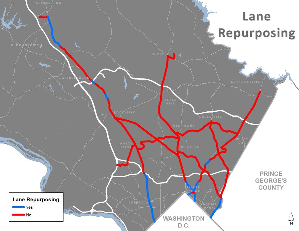
10 4 Transportation Modeling Runs Initial modeling included all median busways treated the same as Light Rail Transit (LRT) to determine maximum potential ridership in 2040 forecast year. No Build: ex. transportation network + Constrained Long Range Plan Build 1: 152 mile network of median busways Build 2: 152 mile network with some dedicated curb lanes achieved via lane repurposing* Build 2A: 87 mile network with a mix of treatments Treatment Build 1 Build 2 Build 2A Two Way Median Curb Lanes Mixed Traffic 17 Total (miles)
11 Definition: Designating an existing or planned travel lane for transit use only, whether during peak periods or all day Recommended where: *Lane Repurposing Forecast transit ridership was greater than the general trafficcarrying capacity of the lane, and Expanding the roadway was determined to be infeasible Consistent with 1993 General Plan Refinement which: Moved away from accommodating travel demand and toward managing travel demand Promoted more efficient use of our rights of way Recommended favoring transit over automobile use
12 Activity Center Corridor Corridor Typology multiple activity centers along its length all day, night and weekend activity and transit demand in both directions variable trip length example: MD355 Express Corridor highly peaked directional split in travel mostly long trips example: US29 north of New Hampshire Avenue Commuter Corridor characteristics that are intermediate between the above two types example: Georgia Avenue
13 Treatment Thresholds Treatment thresholds were lowered to account for: high level of analysis long time frame (beyond 2040 forecast to consider master plan build out) model attributes that could increase ridership up to 30% Transit Capacity and Quality Service Manual (TCQSM) vs. Countywide Transit Corridors Functional Master Plan (CTCFMP) Treatment TCQSM CTCFMP Mixed Traffic <1,200 pphpd <1,000 pphpd Curb Lanes 1,200 to 2,400 pphpd 1,000 1,600 pphpd Median Busway >2,400 pphpd >1,600 pphpd pphpd= passengers per peak hour in the peak direction
14 Corridor Function Network & Treatment Considerations activity center corridor express corridor commuter corridor Forecast Peak Hour Ridership >1,600* = busway 1,000-1,600* = curb lanes <1,000* = mixed traffic *passengers in the peak hour in the peak direction Corridor Treatment 1 or 2-lane median busway or side busway curb lanes mixed traffic
15 2040 Forecast Daily BRT Ridership Corridor Build 1 Build 2 Build 2A MD 355 South 49k 46k 44k MD 355 North 34k 32k 22k Veirs Mill Rd & University Blvd 27k 27k 18k Georgia Avenue (North & South) 24k 24k 12k New Hampshire Avenue 22k 21k 10k US 29 18k 16k 16k Randolph Road 16k 16k 11k Rockville Life Sciences Center 14k 14k 7k Old Georgetown Road South 11k 11k Old Georgetown Road North 8k 8k Muddy Branch Road 8k 8k Connecticut Avenue 6k 7k InterCounty Connector 6k 6k Norbeck Road 6k 5k North Bethesda Transitway 4k 4k 10k University Blvd Grosvenor 2k 2k Total 254k 247k 150k
16 2040 Forecast Daily BRT Ridership Corridor Build 1 Build 2 Build 2A MD 355 South 49k 46k 44k MD 355 North 34k 32k 22k Veirs Mill Rd & University Blvd 27k 27k 18k Georgia Avenue (North & South) 24k 24k 12k New Hampshire Avenue 22k 21k 10k US 29 18k 16k 16k Randolph Road 16k 16k 11k Rockville Life Sciences Center 14k 14k 7k Old Georgetown Road South 11k 11k Old Georgetown Road North 8k 8k Muddy Branch Road 8k 8k Connecticut Avenue 6k 7k InterCounty Connector 6k 6k Norbeck Road 6k 5k North Bethesda Transitway 4k 4k 10k University Blvd Grosvenor 2k 2k Total 254k 247k 150k
17 2040 Forecast Daily BRT Ridership Corridor Build 1 Build 2 Build 2A MD 355 South 49k 46k 44k MD 355 North 34k 32k 22k Veirs Mill Rd & University Blvd 27k 27k 18k Georgia Avenue (North & South) 24k 24k 12k New Hampshire Avenue 22k 21k 10k US 29 18k 16k 16k Randolph Road 16k 16k 11k Rockville Life Sciences Center 14k 14k 7k Old Georgetown Road South 11k 11k Old Georgetown Road North 8k 8k Muddy Branch Road 8k 8k Connecticut Avenue 6k 7k InterCounty Connector 6k 6k Norbeck Road 6k 5k North Bethesda Transitway 4k 4k 10k University Blvd Grosvenor 2k 2k Total 254k 247k 150k

18 ~150k Forecast Daily Ridership
19 Decrease in Vehicle Miles Traveled (VMT) Decrease in Vehicle Hours Traveled (VHT) Daily Benefits Summary No Build Build 1 Build 2 Build 2A 193,800 miles 230,600 miles 143,100 miles 69,600 hours 58,700 hours 28,600 hours Transit User Benefits* 84,333 hours 80,789 hours 39,856 hours *Benefits to all users of the regional transportation network attributable to MC-BRT include a time conversion of other factors including costs, span of service, reliability, passenger amenities, ride quality, number of transfers, and personal safety.
20 Where is Additional ROW Needed?
21 Network & Treatment Considerations BRT Demand Bus Speed Impacts on Other Traffic Transit Corridor Network Property Impacts Local Bus Demand Network Integrity
22 Determining Corridor Treatment Recommended rights of way reflect higher level of treatment in some cases to maintain network integrity Final plan states only whether or not dedicated transit lanes should be provided Implementing agency has flexibility to determine final treatment based on: more detailed ridership forecasts and traffic analysis service planning decisions further refinement of property and environmental impacts and costs
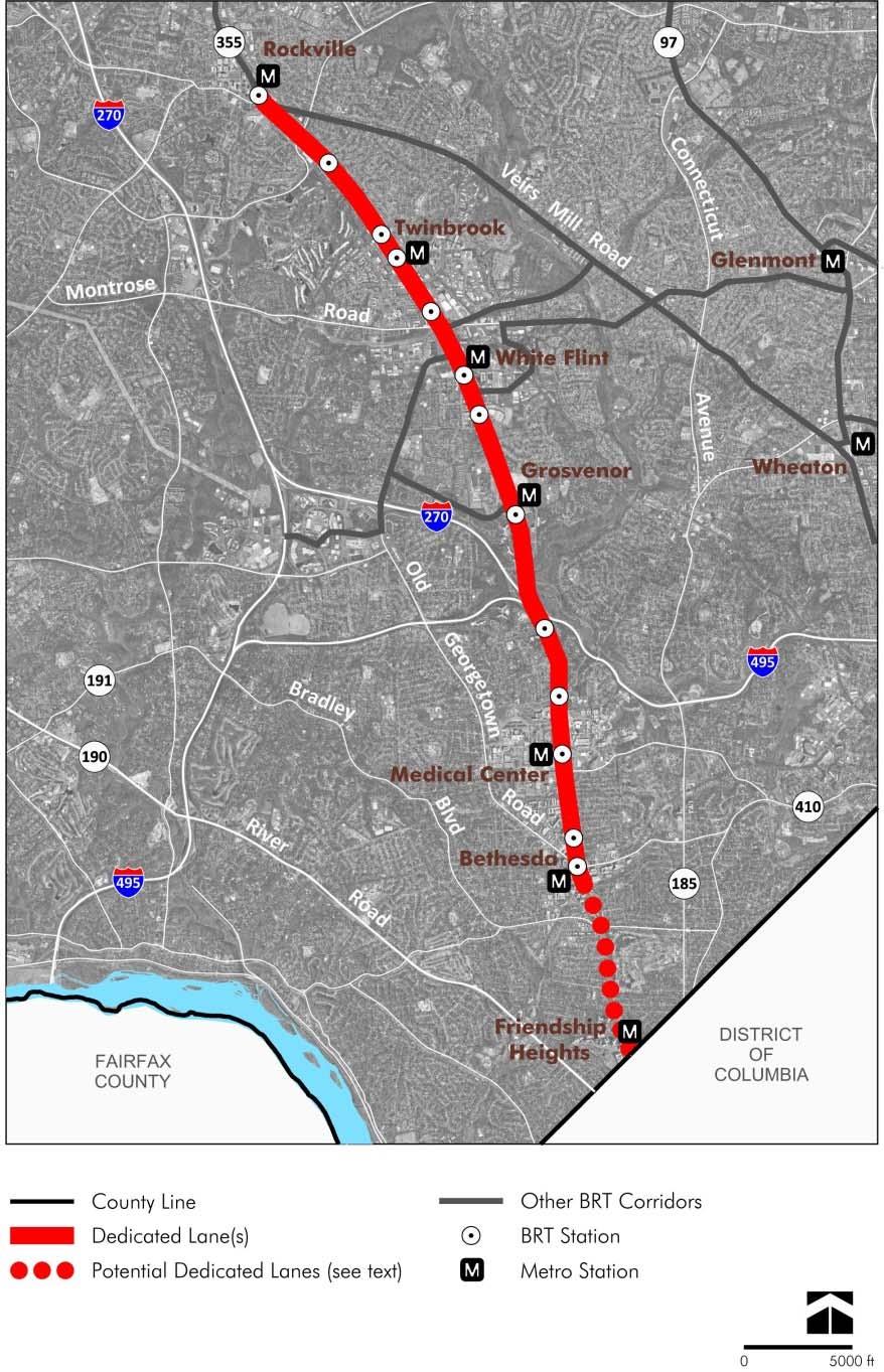
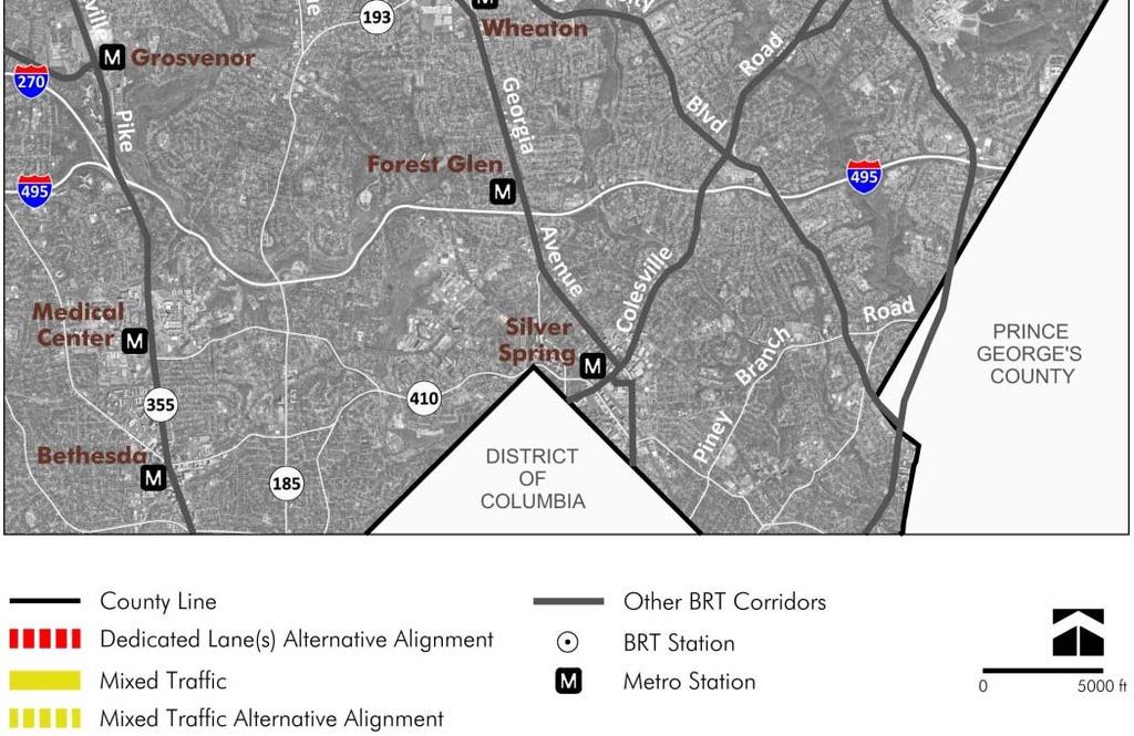
23 Plan Recommendations Ten Transit Corridors plus Corridor Cities Transitway 102 mile network, 80% dedicated lanes Additional ROW recommended where needed to accommodate dedicated lanes and pedestrian & bike facilities Corridor treatments to be determined during Project Planning 125 BRT stations located by nearest intersection
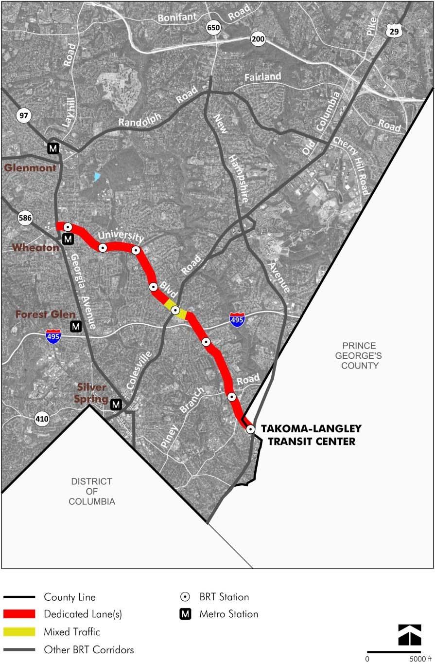
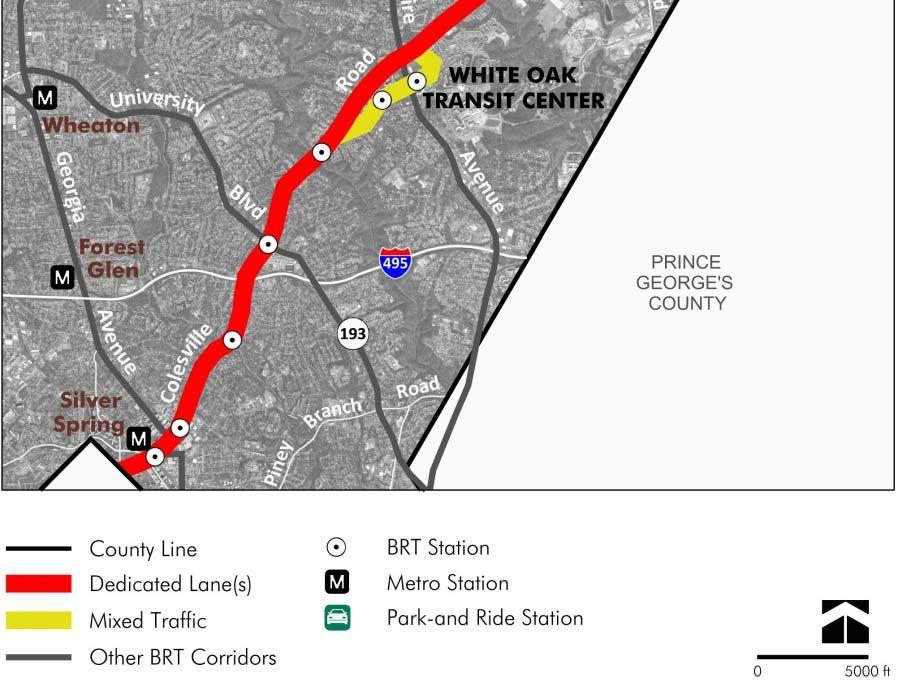
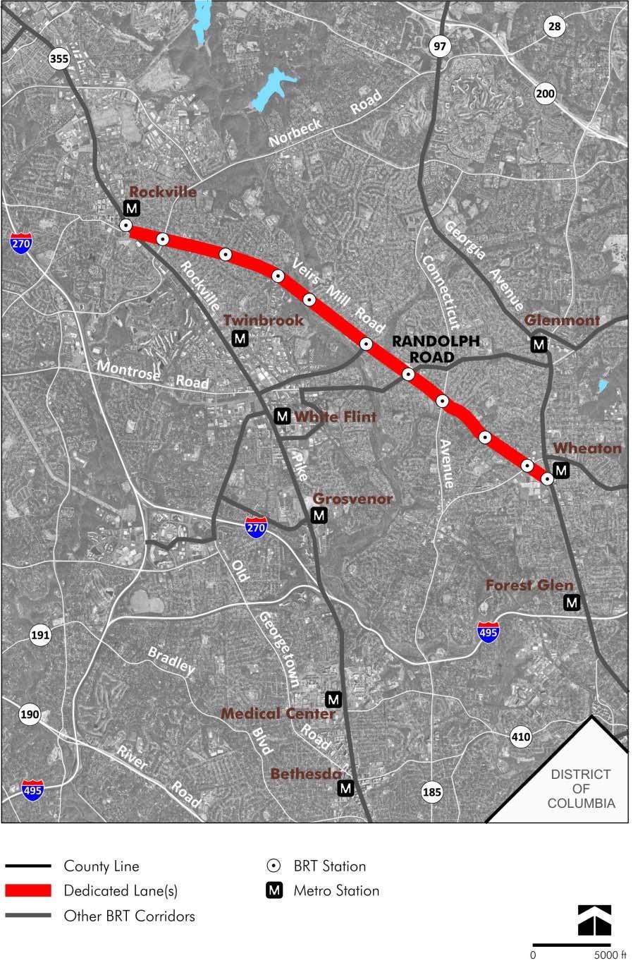
24 Recommended Transit Corridor Network Corridors 1. Georgia Ave North 2. Georgia Ave South 3. MD355 North 4. MD355 South 5. NH Avenue 6. N. Bethesda Twy 7. Randolph Road 8. University Blvd 9. US29 10.Veirs Mill Road CCT. Corridor Cities Transitway
25 Recommended Transit Corridor Network Corridors Dedicated Lanes Mixed Traffic Total Corridor Cities Transitway Georgia Avenue North Georgia Avenue South MD 355 North MD 355 South New Hampshire Avenue North Bethesda Transitway Randolph Road University Boulevard US Veirs Mill Road Grand Total
26 Randolph Road & MD355 North


27 25% 30% 50% 30% 37% 39% 50% 25%* *per White Oak Science Gateway draft Master Plan Recommended Transit Corridor Network w/ Non Auto Driver Mode Share goals
28 Changes by Planning Board and County Council Following Public Input Discussion of potential future expansion of BRT deleted Recommendations for specific transitway treatments deleted in favor of recommending dedicated lanes only Dedicated lanes added on US29 through Four Corners Extension of MD355 transitway south of Bethesda Metro Station made contingent on DC having a similar recommendation Extension of MD355 transitway from Germantown to Clarksburg added as a mixed traffic corridor Additional spurs added on two corridors Alternative alignments added for consideration on two corridors Additional stations recommended
29 Network Length MCDOT Feasibility Study = 150 miles Transit Task Force = 162 miles Countywide Transit Corridors Functional Master Plan = 82 miles Dedicated Lanes Network Comparisons (not incl. Corridor Cities Transitway) Transit Task Force = 162 miles Countywide Transit Corridors Functional Master Plan = 61 miles
30 BRT Corridors in Planning and Design
31 BRT Corridors currently in Planning and Design 1: Georgia Avenue North 2: Georgia Avenue South 3: MD 355 North 4: MD 355 South 5: New Hampshire Ave 6: North Bethesda Twy 7: Randolph Road 8: University Boulevard 9: US 29 10: Veirs Mill Road CCT: Corridor Cities Twy 1
 EllisMo@pbworld.")
32 Contact info: Larry Cole M NCPPC (lead planner) larry.cole@montgomeryplanning.org Monique Ellis Parsons Brinckerhoff (consultant) EllisMo@pbworld.com (410)
33 Countywide Transit Corridors Functional Master Plan Makeover Montgomery II May 10, 2014
34 BRT CORRIDORS IN PLANNING AND DESIGN 1& 10: Georgia Avenue North (Olney to Wheaton Metro) and Veirs Mill Road (Rockville Metro to Wheaton Metro): MD State Highway Administration (SHA) is planning w/county funding 3, 4, & 9: MD 355 North (Clarksburg to Rockville Metro), MD355 South (Rockville Metro to Bethesda Metro/Purple Line), and US29 (Burtonsville to Silver Spring Transit Center): SHA will begin planning shortly w/$10m in State funding and $0.5M in County funding Corridor Cities Transitway (Clarksburg to Shady Grove Metro): MD Transit Administration (MTA) in Preliminary Design for Phase I w/state funding

35 Households Recommended Transit Corridor Network vs Jobs and Households Forecasts Jobs
36 Duplication of Metrorail Most concerns about duplicating Metrorail were about MD355 South but Georgia Avenue South was also referenced. These corridors serve the same area as the two legs of the Red Line but provide a different service that is intermediate between Metrorail and local buses, with a closer stop spacing and less of a time penalty to access the system for moderate length trips. MD 355 and Georgia Ave BRT ridership coming from Red Line ridership Corridor Build 1 Build 2 Build 2A A MD 355 South BRT ridership 48,700 46,000 43,900 B Georgia Avenue North/South BRT ridership 24,300 23,700 12,300 C total ridership coming from Red Line 23,100 21,700 13,900 D % ridership coming from the Red Line 32% 31% 25%
37 Duplication of Metrorail On a network wide basis, the BRT ridership would come from the following sources: 2040 Forecast BRT Network Trips Build 1 Build 2 Build 2A New Transit Trips 58% 57% 50% From Metrobus 12% 12% 15% From Metrorail 9% 9% 10% From Ride On 17% 18% 20% From Other Services 4% 4% 5% Total 100% 100% 100%
38 Existing Daily Bus Ridership Based on data rec d from Institute for Transportation and Development Policy (ITDP)
39 What is BRT?
40 What is Bus Rapid Transit (BRT)? Dedicated Lanes Stylish Vehicles Branded Service Bus Rapid Transit Advanced Technologies Faster Fare Collection Enhanced Stations

41 Enhanced Stations

42 Level boarding areas

43 Off vehicle fare collection

44 Real Time Transit Information
 Branded")


45 Eugene (OR) EmX (from LTD) Branded vehicles Kansas City MAX (from KCATA) Cleveland Silver Line (from GCRTA) Los Angeles Orange Line (from flickr.com)


46 Two lane median Curb lane One lane median Dedicated lanes & corridor treatment types
47 ITDP Demand and Service Planning Report to MCDOT (Dec 2012) The report stated that US29 is not a good candidate for BRT: The main cause of delay was normal congestion which can be resolved with simple dedicated bus lanes in the peak direction, so full BRT on Route 29 does not seem warranted at this time. The report fairly off handedly recommends dedicated lanes as a simple solution, but gaining the space for such lanes is a critical master plan issue. The report is narrowly focused on what constitutes true BRT, whereas the CTCFMP is focused on what ROWs are needed to accommodate both BRT as we see it and other bus services.
48 Gaithersburg Rockville


49 Georgia Avenue North & South

50 MD355 North & South

51 NH Ave & N Bethesda Transitway

52 Randolph Road & University Boulevard

53 US29 & Veirs Mill Road


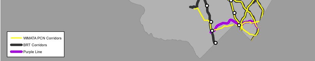
54 WMATA Priority Corridor Network

55 Recommended Transit Corridor Network vs. WMATA Priority Corridor Network
56 Bicycle Pedestrian Priority Areas Designation around station areas will promote better pedestrian/bike accommodation in: design construction operations

57 BPPA Example: Silver Spring CBD West


58 MARC Brunswick Line Expansion Addition of a third track west of Metropolitan Grove will reduce conflicts with freight to increase: capacity flexibility reliability and to enable: more frequent service all day service weekend service
59 2040 Forecast Daily BRT Ridership per Mile Corridor Build 2A MD 355 South 4,700 MD 355 North 2,050 Veirs Mill Rd & University Blvd 1,400 Georgia Avenue (North & South) 900 New Hampshire Avenue 1,150 US 29 1,150 Randolph Road 1,100 North Bethesda Transitway 3,750
Presentation of Staff Draft March 18, 2013 COUNTYWIDE TRANSIT CORRIDORS FUNCTIONAL MASTER PLAN
 Presentation of Staff Draft March 18, 2013 COUNTYWIDE TRANSIT CORRIDORS FUNCTIONAL MASTER PLAN Public Outreach Fall 2011: Two community meetings/open houses Fall 2012: Three community meetings/open houses
Rapid Transit in Montgomery County
 Rapid Transit in Montgomery County Montgomery County Department of Transportation Al Roshdieh, Acting Director 1 Background Corridors in Detail Corridor Cities Transitway MD 355 (Bethesda to Rockville
Abstract. Source of Copies The Maryland-National Capital Park and Planning Commission 8787 Georgia Avenue Silver Spring, MD 20910
 1 Abstract This document contains an examination of and recommendations for transit, bicycle, and pedestrian infrastructure that will help create complete transportation options. With the approval and
MONTGOMERY COUNTY PLANNING DEPARTMENT THE MARYLAND-NATIONAL CAPITAL PARK AND PLANNING COMMISSION
 MONTGOMERY COUNTY PLANNING DEPARTMENT THE MARYLAND-NATIONAL CAPITAL PARK AND PLANNING COMMISSION MCPB Item No. 2 Date: 12-15-11 Network and Methodology Report - Countywide Transit Corridors Functional
MONTGOMERY COUNTY PLANNING DEPARTMENT THE MARYLAND-NATIONAL CAPITAL PARK AND PLANNING COMMISSION
 MONTGOMERY COUNTY PLANNING DEPARTMENT THE MARYLAND-NATIONAL CAPITAL PARK AND PLANNING COMMISSION MCPB Item No. 3 Date: 01-19-12 Worksession: Countywide Transit Corridors Functional Master Plan Larry Cole,
Abstract. Source of Copies The Maryland-National Capital Park and Planning Commission 8787 Georgia Avenue Silver Spring, MD 20910
 1 Abstract This document contains an examination of and recommendations for transit, bicycle, and pedestrian infrastructure that will help create complete transportation options. With the approval and
Bus Rapid Transit Plans
 Twin Cities Region Bus Rapid Transit Plans ULI Minnesota Workshop Connecting Bus Rapid Transit to the Community December 15, 2009 John Levin Director of Service Development Metro Transit Metropolitan Area
Countywide Bus Rapid Transit Study Consultant s Report (Final) July 2011 DEPARTMENT OF TRANSPORTATION. Barrier system (from TOA)
 July 2011 DEPARTMENT OF TRANSPORTATION. Barrier system (from TOA)") Countywide Bus Rapid Transit Study Consultant s Report (Final) July 2011 DEPARTMENT OF TRANSPORTATION Barrier system (from TOA) COUNTYWIDE BUS RAPID TRANSIT STUDY Consultant s Report (Final) July 2011
Countywide Bus Rapid Transit Study Consultant s Report (Final) July 2011 DEPARTMENT OF TRANSPORTATION Barrier system (from TOA) COUNTYWIDE BUS RAPID TRANSIT STUDY Consultant s Report (Final) July 2011
2014 Mobility Assessment Report Functional Planning & Policy Montgomery County Planning Department
 2014 Mobility Assessment Report Functional Planning & Policy Montgomery County Planning Department Travel Trends National & Local Travel Trends Multi-Modal Monitoring Pedestrian Bikes Bus Rail Future Efforts
Preliminary Transportation Analysis
 Preliminary Transportation Analysis Goals of a Robust, Multimodal Transportation Network Safe Accessible/Connected Efficient Comfortable Context-Sensitive Motor Vehicle: Continue to analyze the data to
Appendix G: Bicycle Parking Space Recommendations at Transit Stations
 Appendix G: Bicycle Parking Space Recommendations at Transit Stations Bicycle parking is needed at all Metrorail Red Line, MARC, Purple Line and Corridor Cities Transitway stations. This appendix includes
Spring Lake Park Mounds View North Oaks. Arden Hills. Shoreview. Roseville. Little Canada. Falcon Heights SNELLING. Lilydale. West Saint Paul 35E
 Coon Rapids Blaine Spring Lake Park Mounds View rth Oaks In 2011, Metro Transit embarked on the Arterial 494 Minnetonka Maple Grove Plymouth Hopkins Brooklyn Park New Hope Golden Valley Louis Park Edina
US 29 Bus Rapid Transit Corridor Planning Study FINAL. Corridor Study Report From Silver Spring Transit Center. April 2017
 US 29 Bus Rapid Transit Corridor Planning Study Corridor Study Report From Silver Spring Transit Center to Burtonsville Park and Ride FINAL April 2017 APRIL 2017 Table of Contents page Executive Summary...
MONTGOMERY COUNTY PLANNING DEPARTMENT THE MARYLAND-NATIONAL CAPITAL PARK AND PLANNING COMMISSION
 MONTGOMERY COUNTY PLANNING DEPARTMENT THE MARYLAND-NATIONAL CAPITAL PARK AND PLANNING COMMISSION MCPB Item No. 4 Date: 04-17-14 2014 Mobility Assessment Report José Dory, Senior Planner, Functional Planning
Arterial Transitway Corridors Study. Ave
 Arterial Transitway Corridors Study Ave January 2012 Arterial Transitway Corridors Study Overview Corridor Features and Demographics 11 study corridors, 95 route miles 86,000 daily rides and half of existing
MONTGOMERY COUNTY PLANNING DEPARTMENT
 MONTGOMERY COUNTY PLANNING DEPARTMENT THE MARYLAND-NATIONAL CAPITAL PARK AND PLANNING COMMISSION Veirs Mill Corridor Master Plan: Work Session #5 MCPB Item No. Date: 10/04/18 Jessica McVary, Planner Coordinator,
Description of Planning Board Recommended Network
 I-270 Corridor Interchanges Frederick (MD 355) at Ridge (MD 1 27) New Interchange N/A N/A N/A X X n/a $ 66 2 I-270 at Clopper (MD 117) Upgrade Interchange, Include Park-and-Ride Lot N/A N/A N/A X X X n/a
Roadways. Roadways III.
 Introduction 97 Roadway Design Principles 98 Safe Speeds 99 Optimizing of Street Space 00 Minimum Lane Widths in the City of Boston 02 Design Features that Reduce Operating Speeds 05 Travel Lanes Transit
ALTERNATIVES ANALYSIS EXECUTIVE SUMMARY
 West Valley Connector Corridor ALTERNATIVES ANALYSIS EXECUTIVE SUMMARY FINAL September 2014 Ontario International Airport Ontario Mills Rancho Cucamonga Metrolink Station Kaiser Permanente PARSONS EXECUTIVE
APPENDIX 14: CONNECTIONS: TRANSPORTATION ANALYSIS. Transportation Planning, Analysis
 APPENDIX 14: CONNECTIONS: TRANSPORTATION ANALYSIS Transportation Planning, 2008 Germantown has various options of transportation for citizens in the community. There are major highways, buses, MARC, bicycle
Arterial Transitway Corridors Study
 Arterial Transitway Corridors Study February 2012 Arterial Transitway Corridors Study Overview Corridor Features and Demographics 11 study corridors, 95 route miles Routes: 86,000 daily rides and half
MONTGOMERY COUNTY PLANNING DEPARTMENT THE MARYLAND-NATIONAL CAPITAL PARK AND PLANNING COMMISSION
 MONTGOMERY COUNTY PLANNING DEPARTMENT THE MARYLAND-NATIONAL CAPITAL PARK AND PLANNING COMMISSION MCPB Item No. 4 Date: 09-10-15 Scope of Work for the Bicycle Master Plan David Anspacher, Planner/Coordinator,
PURPOSE AND NEED SUMMARY 54% Corridor Need 1. Corridor Need 2. Corridor Need 3. Corridor Need 4. Corridor Need 5
 SUMMARY PURPOSE AND NEED Chapel Hill Transit ridership has increased Buses operate every 4 minutes and have standing room only Exceeding seated capacity by 12% Corridor Need 1 by more than 20 percent between
Arlington County 10-Year Transit Development Plan & Premium Transit Network Briefing. May 2016
 Arlington County 10-Year Transit Development Plan & Premium Transit Network Briefing May 2016 Overview 10-Year Transit Development Plan Premium Transit Network Columbia Pike service concept Premium amenities
APPENDIX E BIKEWAY PRIORITIZATION METHODOLOGY
 APPENDIX E BIKEWAY PRIORITIZATION METHODOLOGY INTRODUCTION The network of bikeways recommended in the Bicycle Master Plan is extensive and is likely to be only partially completed during the 25-year life
PERFORMANCE ANALYSIS of The Draft 2015 CLRP
 Item 9 PERFORMANCE ANALYSIS of The Draft CLRP Presentation to the Transportation Planning Board September 16, CLRP Performance Analysis 1 What is the Long-Range Transportation Plan (CLRP)? The CLRP identifies
Multimodal Approach to Planning & Implementation of Transit Signal Priority within Montgomery County Maryland
 Multimodal Approach to Planning & Implementation of Transit Signal Priority within Montgomery County Maryland A Path to Successful Implementation James Allday Bunch - Sabra, Wang & Associates, Inc. ITS
WELCOME! Please complete a comment sheet as we value your feedback. 4 pm to 8 pm. September 15, Hosted by: AECOM on behalf of City of Calgary
 WELCOME! Thank you for attending our open house. There will be no formal presentation today so please take the time to read the boards. If you have any questions, please do not hesitate to approach one
Scope of the Transit Priority Project
 Transit Planning Committee #1 March 19, 2015 Scope of the Transit Priority Project Review of the 2010 plan Analysis of Transit Priority Measures Preliminary plans for rapid transit Recommendations for
MONTGOMERY COUNTY PLANNING DEPARTMENT THE MARYLAND-NATIONAL CAPITAL PARK AND PLANNING COMMISSION
 MONTGOMERY COUNTY PLANNING DEPARTMENT THE MARYLAND-NATIONAL CAPITAL PARK AND PLANNING COMMISSION SHA CTP Project No. MO891A21, US 29, Fairland Road to Musgrove Road Interchange Improvement, Design Review
Scottsdale Road/Rural Road Alternatives Analysis (AA) Study. Arizona ITE/IMSA Spring Conference March 7, 2012
 Study. Arizona ITE/IMSA Spring Conference March 7, 2012") Scottsdale Road/Rural Road Alternatives Analysis (AA) Study Arizona ITE/IMSA Spring Conference March 7, 2012 Study Location and Duration Primary Study Corridor (major focus of effort) Rural Road and Scottsdale
Scottsdale Road/Rural Road Alternatives Analysis (AA) Study Arizona ITE/IMSA Spring Conference March 7, 2012 Study Location and Duration Primary Study Corridor (major focus of effort) Rural Road and Scottsdale
Corridor Advisory Group and Task Force Meeting #10. July 27, 2011
 Corridor Advisory Group and Task Force Meeting #10 July 27, 2011 1 Agenda Recap CAG/TF #9 Public Meeting #2 Summary Single Mode Alternatives Evaluation Results Next Steps 2 3 CAG/TF #9 Recap CAG /TF #9
Bus Rapid Transit ALTERNATIVES ANALYSIS. Open House
 Bus Rapid Transit ALTERNATIVES ANALYSIS Open House June 23, 2015 Open House Meeting Agenda Agenda Introductions What is BRT? Project Goals Study Tasks Next steps Discussion PVTA Bus Rapid Transit Study
MONTGOMERY COUNTY PLANNING DEPARTMENT THE MARYLAND-NATIONAL CAPITAL PARK AND PLANNING COMMISSION
 MONTGOMERY COUNTY PLANNING DEPARTMENT THE MARYLAND-NATIONAL CAPITAL PARK AND PLANNING COMMISSION MCPB Item No. 9 Date: 01-09-14 MD355 Crossing (BRAC) Project, CIP Project 501209, Mandatory Referral No.
Proposed White Flint Separated Bike Lane Network September 2015
 Proposed White Flint Separated Bike Lane Network September 2015 Abstract This report includes a proposed separated bike lane network for the White Flint Sector Plan area. Separated bike lanes create a
Chapter 3 BUS IMPROVEMENT CONCEPTS
 Chapter 3 BUS IMPROVEMENT CONCEPTS The purpose of this chapter is to describe potential bus improvement strategies and potential impacts or implications associated with BRT implementation within the existing
the Story of the 30s & 70s Bus Lines James Hamre - WMATA
 Evaluation of a Service Restructuring: the Story of the 30s & 70s Bus Lines James Hamre - WMATA Metrorail is the second largest rail transit system in the nation 230 million annual riders 780,000 weekday
Washington DC Section of ITE Project Briefing
 Washington DC Section of ITE Project Briefing November 5, 2015 Renée Hamilton, VDOT, Deputy District Administrator I-66 Outside the Beltway Improvement Area Project Location Virginia 2 Purpose and Need
Bus Rapid Transit on Silicon Valley s El Camino Real: Working Together to Create a Grand Boulevard Steven Fisher
 Bus Rapid Transit on Silicon Valley s El Camino Real: Working Together to Create a Grand Boulevard Steven Fisher Senior Transportation Planner Santa Clara Valley Transportation Authority San Jose, CA How
BRIEFING ON PROPOSED ADDITIONS AND CHANGES Additions and Changes to Projects Proposed for Inclusion in the 2015 CLRP Update
 BRIEFING ON PROPOSED ADDITIONS AND CHANGES Additions and Changes to Projects Proposed for Inclusion in the 2015 CLRP Update January 23, 2015 Travel Forecasting Subcommittee What is the CLRP? Federally
South King County High-Capacity Transit Corridor Study
 HIGH-CAPACITY TRANSIT CORRIDOR STUDY South King County Corridor South King County High-Capacity Transit Corridor Study Corridor Report August 2014 South King County High Capacity Transit Corridor Report
Prioritization of Bicycle Supportive Laws, Regulations and Policies. Recommended Expanded Bicycle-Supportive Programs
 1) Table of Contents, Add these subsections: s Bicycle Facility Classifications General Application Breezeway Network Recommendations Bicycle Parking Short-Term Bicycle Parking Long-Term Bicycle Parking
Southwest Bus Rapid Transit (SW BRT) Functional Planning Study - Executive Summary January 19 LPT ATTACHMENT 2.
 Functional Planning Study - Executive Summary January 19 LPT ATTACHMENT 2.") Southwest Bus Rapid Transit (SW BRT) Functional Planning Study - Executive Summary 2011 January 19 1 of 19 Introduction This executive summary presents the results of the Southwest Bus Rapid Transit (SW
Southwest Bus Rapid Transit (SW BRT) Functional Planning Study - Executive Summary 2011 January 19 1 of 19 Introduction This executive summary presents the results of the Southwest Bus Rapid Transit (SW
5. RUNNINGWAY GUIDELINES
 5. RUNNINGWAY GUIDELINES These guidelines should be considered collectively when making runningway decisions. A runningway is the linear component of the transit system that forms the right-of-way reserved
WHAT IS BRT? Jack M. Gonsalves, PE, Parsons Brinckerhoff, Inc. February 22, 2012
 WHAT IS BRT? Jack M. Gonsalves, PE, Parsons Brinckerhoff, Inc. February 22, 2012 What is Bus Rapid Transit (BRT)? A flexible, high performance rapid transit mode that combines a variety of physical, operating,
Eliminate on-street parking where it will allow for a dedicated bus only lane %
 Traffic Dashboard Priorities Survey Responses Introduction 1) Are you familiar with bus rapid transit (BRT)? a. No, BRT is new to me. 597 23.5% b. I ve heard of BRT, but I don t know much about it. 1,136
The Nexus between Transportation Demand Your sub title Management (TDM), Transit Station Access, and Internal Station Circulation
, Transit Station Access, and Internal Station Circulation") YOUR LINKING TITLE THE LINKS The Nexus between Transportation Demand Your sub title Management (TDM), Transit Station Access, and Internal Station Circulation Presentation Makeover Montgomery Location
YOUR LINKING TITLE THE LINKS The Nexus between Transportation Demand Your sub title Management (TDM), Transit Station Access, and Internal Station Circulation Presentation Makeover Montgomery Location
Main-McVay Transit Study: Phase 2 Options Definition and High Level Constraints Evaluation
 Main-McVay Transit Study: Phase 2 Options Definition and High Level Constraints Evaluation APRIL 2016 A collaborative study between: For Additional Information or to Comment If you would like additional
1. Operate along freeways, either in regular traffic lanes, in high-occupancy vehicle (HOV) lanes, or along the shoulders.
 lanes, or along the shoulders.") Most decisions about whether or not to use transit involve time and cost, and most transit services are slower than travel by private vehicle. However, when transit is faster or nearly as fast as travel
Most decisions about whether or not to use transit involve time and cost, and most transit services are slower than travel by private vehicle. However, when transit is faster or nearly as fast as travel
EL CAMINO REAL BUS RAPID TRANSIT (BRT) PROJECT
 PROJECT") Agenda Item #4.2 EL CAMINO REAL BUS RAPID TRANSIT (BRT) PROJECT VTA BOARD WORKSHOP MAY 1, 2015 ABOUT THIS PRESENTATION CONTEXT Existing conditions and planning for growth WHAT IS THE PROJECT? Project alternatives
Agenda Item #4.2 EL CAMINO REAL BUS RAPID TRANSIT (BRT) PROJECT VTA BOARD WORKSHOP MAY 1, 2015 ABOUT THIS PRESENTATION CONTEXT Existing conditions and planning for growth WHAT IS THE PROJECT? Project alternatives
FY2006 Budget Board Budget Committee request for information. Board Request: Detailed information on bus route 5A DC-Dulless Airport
 Board Request: Detailed information on bus route 5A DC-Dulless Airport Tracking Number: 29 Assigned to Dept/Office: OPER Contact Person: Jim Hughes Metrobus Route 5A was established in December 2000 in
TRANSIT PERFORMANCE IN THE I-66 INSIDE THE BELTWAY CORRIDOR
 TRANSIT PERFORMANCE IN THE I-66 INSIDE THE BELTWAY CORRIDOR June 2018 This report summarizes the performance of public transportation systems serving the I-66 inside the Beltway corridor in Northern Virginia.
Arterial Transitway Corridors Study. Sept. 26, 2011
 Arterial Transitway Corridors Study Sept. 26, 2011 Purpose of Study Study 11 urban corridors in Minneapolis, St. Paul and surrounding communities Develop service and facilities plan to improve Transit
Purpose and Need. Chapter Introduction. 2.2 Project Purpose and Need Project Purpose Project Need
 Chapter 2 Purpose and Need 2.1 Introduction The El Camino Real Bus Rapid Transit (BRT) Project (Project) would make transit and other transportation improvements along a 17.6-mile segment of the El Camino
ADVANCED TRANSIT OPERATIONS AND MODELING
 SOUTHERN DISTRICT OF INSTITUTE OF TRANSPORTATION ENGINEERS (SDITE) 2017 ADVANCED TRANSIT OPERATIONS AND MODELING SURESH KARRE, PE, PTOE ROBERT DUBNICKA, PE, TE, PTOE AGENDA Background Transit operations
Fitting Light Rail through Well-established Communities
 Fitting Light Rail through Well-established Communities San Francisco 2008 Michael D. Madden Chief, Project Development, Maryland Transit Administration Project Setting Located inside the Capital Beltway
MONTGOMERY COUNTY COUNCIL
 MONTGOMERY COUNTY COUNCIL R O C K V I L L E, M A R Y L A N D October 20, 2015 The Honorable Isiah Leggett Montgomery County Executive 101 Monroe Street, 2nd Floor Rockville, MD 20850 Dear County Executive
Measuring and Communicating Mobility:
 Measuring and Communicating Mobility: The District Mobility Project Stephanie Dock, District Department of Transportation TRB Transportation Issues in Major Cities Committee May 2, 2017 Deconstructing
Wilshire Boulevard Bus Rapid Transit Project
 Los Angeles County Metropolitan Transportation Authority Wilshire Boulevard Bus Rapid Transit Project COMMUNITY MEETINGS November 2008 Agenda Introduction Proposed Project Overview Participating Agencies
In station areas, new pedestrian links can increase network connectivity and provide direct access to stations.
 The Last Mile Planning for Pedestrians Planning around stations will put pedestrians first. Making walking to stations safe and easy is important; walking will be a part of every rapid transit Accessible
December For more information, call the Area 2 Division at (301)
") December 2013 Appendix B: Transportation Analysis For more information, call the Area 2 Division at (301) 495-4500 GLENMONT SECTOR PLAN TRANSPORTATION APPENDIX November 8, 2013 1 Contents Purpose Transportation
December 2013 Appendix B: Transportation Analysis For more information, call the Area 2 Division at (301) 495-4500 GLENMONT SECTOR PLAN TRANSPORTATION APPENDIX November 8, 2013 1 Contents Purpose Transportation
METRO RTA TRANSIT MASTER PLAN. May 25-26, 2011
 METRO RTA TRANSIT MASTER PLAN May 25-26, 2011 WHAT IS THE TRANSIT MASTER PLAN? A twenty-year plan for METRO RTA What will METRO look like in 2031? 1 TRANSIT TECHNOLOGIES 2 TRANSIT TECHNOLOGIES Transit
Metropolitan Council Transportation Committee
 Nicollet-Central Transit Alternatives Metropolitan Council Transportation Committee August 2013 Project Purpose (approved by Policy Advisory Committee 10/25/2012) The purpose is to improve transit connectivity,
DULLES AREA TRANSPORTATION ASSOCIATION (DATA) February 18, Susan Shaw, P.E., VDOT, Megaprojects Director
 February 18, Susan Shaw, P.E., VDOT, Megaprojects Director") DULLES AREA TRANSPORTATION ASSOCIATION (DATA) February 18, 2015 Susan Shaw, P.E., VDOT, Megaprojects Director I-66 Corridor Conditions Steady population growth Employment growth in activity centers Congestion
DULLES AREA TRANSPORTATION ASSOCIATION (DATA) February 18, 2015 Susan Shaw, P.E., VDOT, Megaprojects Director I-66 Corridor Conditions Steady population growth Employment growth in activity centers Congestion
BRT for Berkeley A Proposal for Consideration
 BRT for Berkeley A Proposal for Consideration CITY OF BERKELEY STAFF PROPOSAL FOR A LOCALLY PREFERRED ALTERNATIVE OF THE EAST BAY BUS RAPID TRANSIT PROJECT SEPTEMBER 8, 2009 Table of Contents Executive
Central Jersey Transportation Forum. March 2007
 Central Jersey Transportation Forum March 2007 Feasibility Analysis of BRT on Dinky Right of Way from Princeton Station to Alexander Rd. in West Windsor (west of Rt. 1) Study spurred by Princeton University's
WHITE OAK SCIENCE GATEWAY MASTER PLAN Transportation Appendix
 WHITE OAK SCIENCE GATEWAY MASTER PLAN Transportation Appendix Montgomery County Planning Department M-NCPPC www.montgomeryplanning.org Contents Master Plan and Study Area Boundaries... 1 Existing Conditions
Community Task Force July 25, 2017
 Community Task Force July 25, 2017 Welcome and Introductions Project Partners Regional Transportation District (RTD) Colorado Department of Transportation (CDOT) Denver Regional Council of Governments
Washington Metropolitan Area Transit Authority Board Action/Information Summary. MEAD Number:
 Washington Metropolitan Area Transit Authority Board Action/Information Summary Action Information MEAD Number: 100962 Resolution: Yes No TITLE: Bicycle and Pedestrian Access Improvements Study PURPOSE:
City of Gainesville Transportation/Roadway Needs PROJECT SUMMARY
 A1 Roadway Resurfacing $23,846,000 TYPE: Preservation of existing system Roadway resurfacing A2 Signal Replacement $6,000,000 TYPE: Preservation of existing system Replace traffic signals. B1 W 6th St
Washington Metropolitan Area Transit Authority Board Action/Information Summary
 Washington Metropolitan Area Transit Authority Board Action/Information Summary Action Information MEAD Number: 200242 Resolution: Yes No TITLE: MWCOG Strategic Investment Plan & TPB Priorities PRESENTATION
MOBILITY WORKSHOP. Joint City Council and Transportation Commission May 5, 2014
 MOBILITY WORKSHOP Joint City Council and Transportation Commission May 5, 2014 Review of General Plan M-1 Develop world-class transit system M-3 Maintain/enhance pedestrian-oriented City M-4 Create comprehensive
Complete Street Analysis of a Road Diet: Orange Grove Boulevard, Pasadena, CA
 Complete Street Analysis of a Road Diet: Orange Grove Boulevard, Pasadena, CA Aaron Elias, Bill Cisco Abstract As part of evaluating the feasibility of a road diet on Orange Grove Boulevard in Pasadena,
Appendix F: Detailed Modeling Results
 Appendix F: Detailed Modeling Results TransAction Technical Report (This page intentionally left blank) METHODOLOGY FOR CALCULATION OF PERFORMANCE MEASURES F-3 (This page intentionally left blank) Approved
Ownership Lots 17 & 18 (Part of Lot 14), Montgomery Auto Sales Park
, Montgomery Auto Sales Park") Traffic Impact Analysis Ownership Lots 17 & 18 (Part of Lot 14), Montgomery Auto Sales Park Silver Spring, MD Lot 17: Site Plan No. 821413 Lot 18: Site Plan No. 821414 Filing Number: 13-TS-1198527A Prepared
Traffic Impact Analysis Ownership Lots 17 & 18 (Part of Lot 14), Montgomery Auto Sales Park Silver Spring, MD Lot 17: Site Plan No. 821413 Lot 18: Site Plan No. 821414 Filing Number: 13-TS-1198527A Prepared
Comments EXECUTIVE SUMMARY
 Comments 1. Under any Alternatives, MCDOT should provide better at-grade pedestrian crossing of Georgia Avenue and Forest Glen Road, including improved crosswalks with wider medians and adequate signal
MONTGOMERY COUNTY PLANNING DEPARTMENT THE MARYLAND-NATIONAL CAPITAL PARK AND PLANNING COMMISSION
 MONTGOMERY COUNTY PLANNING DEPARTMENT THE MARYLAND-NATIONAL CAPITAL PARK AND PLANNING COMMISSION MCPB Item No. 5 Date: 12/3/15 Draft White Flint Separated Bike Lanes Network David Anspacher, Functional
I-105 Corridor Sustainability Study (CSS)
") I-105 Corridor Sustainability Study (CSS) Metro Streets and Freeways Subcommittee March 21, 2019 Gary Hamrick Cambridge Systematics, Inc. I-105 CSS Project History & Background Funded by Caltrans Sustainable
I-105 Corridor Sustainability Study (CSS) Metro Streets and Freeways Subcommittee March 21, 2019 Gary Hamrick Cambridge Systematics, Inc. I-105 CSS Project History & Background Funded by Caltrans Sustainable
Appendix A-K Public Information Centre 2 Materials
 Appendix A-K Public Information Centre 2 Materials Our Rapid Transit Initiative Make an impact on the future of transit Join the discussion on Rapid Transit in London You re invited to a Public Information
BETHEL ROAD AND SEDGWICK ROAD CORRIDOR STUDY
 DRAFT PLAN City Council Meeting August 14, 2017 STUDY AREA Sedgwick Corridor State Route 160, principal arterial with Class 3 access management designation, commuter and freight route, connection to SR
Previous Transit Studies MTTF MEETING #
 Previous Transit Studies MTTF MEETING #4 2013-03-22 Agenda Project timeline Final transit recommendation (2011) Transit planning and development (2002 2011) Moving forward (2011 2013) 2 Project Timeline
C C C
 C-012-001 Thank you for your support for the creation of new public space and nonmotorized access between downtown and the waterfront through the Overlook Walk, the East-West Connections, and the Promenade.
MONTGOMERY COUNTY CLIMATE PROTECTION PLAN TRANSPORTATION
 MONTGOMERY COUNTY CLIMATE PROTECTION PLAN TRANSPORTATION What impact do transportation policies in Montgomery County have on our environment? In 2009, Montgomery County developed a Climate Protection Plan
Regional Transportation Needs Within Southeastern Wisconsin
 Regional Transportation Needs Within Southeastern Wisconsin #118274 May 24, 2006 1 Introduction The Southeastern Wisconsin Regional Planning Commission (SEWRPC) is the official areawide planning agency
ITEM 13 - Information March 19, Briefing on Final Report of the TPB Regional Value Pricing Study
 ITEM 13 - Information March 19, 2008 Briefing on Final Report of the TPB Regional Value Pricing Study Staff Recommendation: Receive briefing on the final report for the study, which was reviewed by the
Van Ness Avenue BRT Overview and Scoping Process. Geary BRT CAC January 8, 2009
 Van Ness Avenue BRT Overview and Scoping Process Geary BRT CAC January 8, 2009 VAN NESS AVENUE S ROLE Identified in Prop K for BRT treatment Muni 47 and 49; 19 operates on Polk 20,000 daily riders on Van
EVAN GLASS. Montgomery County Council District 5
 EVAN GLASS 1. Do you support funding and advancing the Purple Line to groundbreaking as described in the Locally Yes. As a member of the recently convened Purple Line Implementation Advisory Group, I will
Transit Signal Priority (TSP) Application to Miami-Dade Transit
 Application to Miami-Dade Transit") Transit Signal Priority (TSP) Application to Miami-Dade Transit Amar Sarvepalli Parsons Brinckerhoff Southeast Florida FSUTMS Users Group August 15, 2008 Overview PART A WHAT IS TSP INTRODUCTION PURPOSE
Transit Signal Priority (TSP) Application to Miami-Dade Transit Amar Sarvepalli Parsons Brinckerhoff Southeast Florida FSUTMS Users Group August 15, 2008 Overview PART A WHAT IS TSP INTRODUCTION PURPOSE
Set of plans containing details for game day operations of the Ballpark. Plans set forth the responsibilities and the specific actions of:
 What is the TOPP? Set of plans containing details for game day operations of the Ballpark. Plans set forth the responsibilities and the specific actions of: Ballpark management, District Department of
DRAFT. Memo. Range of the Alternatives Considered in the EIS
 Memo Date: Friday, December 09, 2016 Project: To: From: Subject: State Route 30 EIS UDOT Vince Izzo This memorandum summarizes the draft State Route (S.R.) 30 Level 1 screening results. A more detailed
Dulles Area Transportation Association. October 11, Susan Shaw, P.E., Megaprojects Director Virginia Department of Transportation
 Dulles Area Transportation Association October 11, 2017 Susan Shaw, P.E., Megaprojects Director Virginia Department of Transportation Transform 66: Outside the Beltway 2 Project Overview Multimodal improvements
Technical Working Group November 15, 2017
 Technical Working Group November 15, 2017 Welcome and Introductions Project Partners Regional Transportation District (RTD) Colorado Department of Transportation (CDOT) Denver Regional Council of Governments
Gratiot Avenue Transit Study Tech Memo #4: Ridership
 Gratiot Avenue Transit Study Tech Memo #4: Ridership 5/31/2016 Table of Contents 1 INTRODUCTION... 3 PROJECT DESCRIPTION... 3 2 TECH MEMO #4 OVERVIEW... 5 METHODOLOGY... 5 3 THE ALTERNATIVES AND POTENTIAL
Figure 1: East West Connector Alignment Alternatives Concept Drawing
 Page 2 of 9 Figure 1: East West Connector Alignment Alternatives Concept Drawing The Montebello Drive extension will run north south and connect Wilsonville Road to the Boones Ferry Road to Brown Road
El Camino Real Bus Rapid Transit Conceptual Engineering. Los Altos Council Workshop January 24, 2012
 El Camino Real Bus Rapid Transit Conceptual Engineering Los Altos Council Workshop January 24, 2012 Agenda Introduction Growth in the El Camino Real Corridor Benefits of BRT El Camino Real BRT Decision
M14A/D Select Bus Service
 M14A/D Select Bus Service Manhattan Community Board 6: April 1, 2019 New York City Transit 2 Background M14 Select Bus Service M14 was identified as a critical future SBS corridor in past BRT studies as
Locally Preferred Alternative Report May 27, North-South Corridor Study
 Locally Preferred Alternative Report May 27, 2016 North-South Corridor Study i Table of Contents 1. Executive Summary... 4 2. Introduction... 6 2.1 Project Overview... 6 2.2 Project Process... 8 2.3 Project
Seattle Transit Master Plan
 Seattle Transit Master Plan Seattle City Council Transportation Committee Briefing July 26, 2011 Seattle Department of Transportation In Association with: URS Corporation SVR DKS Associates The Underhill
Aurora Corridor to E Line
 Aurora Corridor to E Line Jack Whisner Transit Planner, Service Development King County Metro Transit Seattle, Washington jack.whisner@kingcounty.gov 206-477-5847 King County Metro Transit Part of general
Item B1 November 19, 2009
 November 19, 2009 Planning and Development Department Land Use Planning Division DATE: November 19, 2009 STAFF REPORT TO: FROM: SUBJECT: Members of the Transportation Commission Elizabeth Greene Senior