Bistro 6. City of Barrie. Traffic Impact Study for Pratt Hansen Group Inc. Type of Document: Final Report. Project Number: JDE 1748
|
|
|
- Barnaby Powers
- 5 years ago
- Views:
Transcription


1 City of Barrie Traffic Impact Study for Pratt Hansen Group Inc. Type of Document: Final Report Project Number: JDE 1748 Date Submitted: June 12 th, /12/17 John Northcote, P.Eng. Professional License #: JD Northcote Engineering Inc. 86 Cumberland Street Barrie, ON
2 Legal Notification Pratt Hansen Group Inc. This report was prepared by JD Northcote Engineering Inc. for the account of Pratt Hansen Group Inc. Any use which a third party makes of this report, or any reliance on or decisions to be made based on it, are the responsibility of such third parties. JD Northcote Engineering Inc. accepts no responsibility for damages, if any, suffered by any third party as a result of decisions made or actions based on this project. ii
3 Table of Contents Pratt Hansen Group Inc. 1 Introduction Background Study Area Study Scope and Objectives Horizon Year and Analysis Periods Information Gathering Street and Intersection Characteristics Local Transportation Infrastructure Improvements Horizon Year Traffic Volumes Proposed Development Traffic Generation and Assignment Traffic Generation Traffic Assignment Total Horizon Year Traffic Volumes with the Proposed Development Intersection Operation with Proposed Development Introduction Total (2020) Intersection Operation Total (2021) Intersection Operation Total (2031) Intersection Operation Sight Distance Review Barrie South GO Station Access Phasing and Site Access Construction Parking Summary List of Tables Table 1 Estimated Traffic Generation of Proposed Development... 9 Table 2 Distribution of Traffic from the Proposed Development... 9 Table 3 Site Access Summary Table 4 Level of Service Criteria for Intersections Table 5 Total (2020) LOS Table 6 Total (2021) LOS Table 7 Total (2031) LOS iii
4 List of Figures Figure 1 Proposed Site Location and Study Area... 2 Figure 2 Existing (2017) Intersection Spacing and Lane Configuration with in Study Area... 4 Figure 3 Background (2020) Traffic Volumes... 6 Figure 4 Background (2021) Traffic Volumes... 7 Figure 5 Background (2031) Traffic Volumes... 8 Figure 6 Subject Site Traffic Assignment (2020) Figure 7 Subject Site Traffic Assignment (2021) Figure 8 Subject Site Traffic Assignment (2031) Figure 9 Total (2020) Traffic Volumes Figure 10 Total (2021) Traffic Volumes Figure 11 RIRO Access Redistribution Figure 12 Total (2031) Traffic Volumes List of Appendices APPENDIX A Crisdawn Lands Functional Design Review and Hewitt Transportation Study Excerpts APPENDIX B Site Plan APPENDIX C Synchro Analysis Output Total Traffic Volumes APPENDIX D OTM Signal Justification Sheets iv
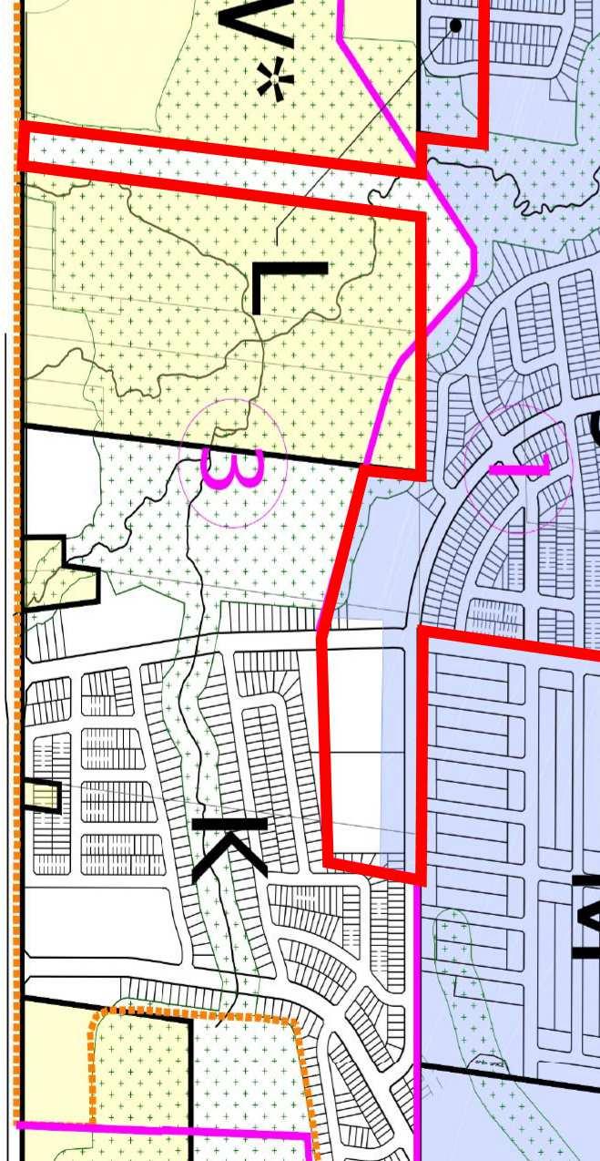
5 1 Introduction 1.1 Background Pratt Hansen Group Inc. [The Developer] is proposing to develop a high-density residential phase [subject site] of the Crisdawn Lands located within Block 613 of the Hewitt s Gate Subdivision in the City of Barrie [City]. The Crisdawn Lands are located on the south side of Mapleview Drive between Yonge Street and 20 th Sideroad (excerpt showing the Crisdawn Lands area provided in Appendix A). The subject site is located on the southeast corner of the future collector road [Street D] within the Crisdawn Lands area. The subject site includes six residential apartment buildings with a total of 440 units. The proposed development includes a right-in, right-out access [RIRO] onto Mapleview Drive East [RIRO Access] and two full-movement access driveways onto the future collector road [North Street D Access and South Street D Access]. The City has confirmed that the RIRO Access can operate as a fullmovement access prior to the reconstruction of Mapleview Drive East (construction currently scheduled to start in 2022). The Developer has retained JD Northcote Engineering Inc. [JD Engineering] to prepare this traffic brief in support of the proposed phase of the residential development. A Transportation Study was completed for the Hewitt Secondary Plan Area, dated February 2017 by LEA Consulting Ltd. [Hewitt Transportation Study], which functions as the traffic study for the Draft Plans of Subdivision for the lands within the Hewitt Secondary Plan Area. A Functional Design Review by LEA Consulting Ltd. was also completed for the proposed draft plan of subdivisions for the Crisdawn Construction Inc. Lands (now referred to as the Hewitt s Gate subdivision), dated February 2017 [Crisdawn FDR]. This traffic brief will build on the findings of these previous studies. 1.2 Study Area Figure 1 shows the location of the subject site and study area intersections in relation to the surrounding area. The Conceptual Site Plan by Jones Consulting Group Limited is shown in Appendix B. The subject site is bound by Mapleview Drive East to the north and the undeveloped Crisdawn Lands to the west, south and east. Through consultation with the City, the following intersections are included in the Traffic Brief: Mapleview Drive East/ RIRO Access; North Street D Access / Street D; and South Street D Access / Street D. 1

6 Figure 1 Proposed Site Location and Study Area 1.3 Study Scope and Objectives The purpose of this study is to identify the potential impacts to traffic flow at the site access and on the surrounding roadway network. The study analysis includes the following tasks: Consult with the City to address any traffic-related issues or concerns they have with the proposed development; Determine existing traffic volumes and circulation patterns; Estimate future traffic volumes if the proposed development was not constructed, including the impact of additional proposed developments in the area based on the Hewitt Transportation Study; Estimate the amount of traffic that would be generated by the proposed development and assign to the roadway network; Complete level-of-service [LOS] analysis of horizon year (with the proposed development) traffic conditions and identify additional operational deficiencies; Identify improvement options to address operational deficiencies; 2
7 Review the available sight distance at all site access driveways; Complete a review of traffic calming requirements within the study area; Review and comment on how pedestrians will access Mapleview Drive East and cross midblock to access the GO Train Station; Review and comment on the phasing of build-out in relation to the construction of Street D and the proposed internal roadways / site entrances; Review and comment on the construction staging plan as it relates to parking of trades people, delivery of construction material, maintenance of adjacent property access, pedestrian movements, City infrastructure, etc.; and Document findings and recommendations in a final report. 1.4 Horizon Year and Analysis Periods Traffic scenarios for 67% buildout year (2020), full-buildout year (2021) and 10-year post full-buildout year (2031) were selected for analysis of traffic operations in the study area. The weekday morning [AM] and weekday afternoon [PM] peak hours have been selected as the analysis periods for this study. 2 Information Gathering 2.1 Street and Intersection Characteristics Mapleview Drive East is a two-lane major arterial road with paved shoulders and an urban cross section within the study area. Mapleview Drive East generally has a sidewalk on the north side of the road within the study area. Mapleview Drive East has a posted speed limit of 60km/h and is under the jurisdiction of the City within the study area. The existing intersection spacing and lane configuration within the study area is illustrated in Figure 2. 3

8 Figure 2 Existing (2017) Intersection Spacing and Lane Configuration with in Study Area 2.2 Local Transportation Infrastructure Improvements According to the City of Barrie Multi-Modal Active Transportation Master Plan [MMATMP], the following road improvements were anticipated to be completed prior to 2016, but have not been completed at the time of this study: Mapleview Drive East (within study area) o Addition of one lane in both directions plus a two way left turn lane Through discussions with City staff, construction for the above-noted road widening is anticipated to begin in
9 2.3 Horizon Year Traffic Volumes The Hewitt Transportation Study analyzes the impact of the entire Hewitt Lands, including a detailed traffic study for each land parcel including the Crisdawn Lands. Traffic volumes for the Mapleview Drive East / Street D intersection during the 2020 PM, 2031 AM and 2031 PM peak hours were calculated in this study 1 (excerpts are provided in Appendix A). Since the 2020 AM peak hour traffic projections were not calculated as a part of the Hewitt Transportation Study, we have estimated the 2020 AM peak hour traffic volumes using the 2020 and 2031 PM peak hour traffic volumes assuming the same ratio of traffic will exist in 2020 compared to 2031 for both the AM and PM peak hour. Linear traffic growth from 2020 to 2031 for the AM and PM peak hour has been assumed. The AM and PM peak hour traffic volumes for the 2021 horizon year scenario have been estimated using this traffic growth rate assumption. Figure 3, 4 and 5 illustrate the background (2020, 2021 and 2031) AM and PM peak hour traffic volumes within the study area. 1 Street D is identified as Street 1 in the Hewitt Transportation Study 5
 Traffic")
10 Figure 3 Background (2020) Traffic Volumes 6
11 Figure 4 Background (2021) Traffic Volumes 7
12 Figure 5 Background (2031) Traffic Volumes 8
13 3 Proposed Development Traffic Generation and Assignment 3.1 Traffic Generation The traffic generation for the subject site has been based on the Crisdawn FDR. Residential traffic generation in the Crisdawn FDR was based on trip rates obtained from a proxy site survey of the residential development located along Prince William Way between Mapleview Drive and Big Bay Point Road. The trip rates for the above-noted proxy site and the estimated trip generation of the proposed development is illustrated below in Table 1. Development Table 1 Estimated Traffic Generation of Proposed Development Size AM Peak Hour PM Peak Hour IN OUT TOTAL IN OUT TOTAL Crisdawn Lands FDR Proxy Site Subject Site 67% Buildout 293 units Subject Site Full Buildout 440 units In order to be conservative, no transportation modal split has been applied to the above-noted traffic generation calculation. 3.2 Traffic Assignment For the purposes of this study, it has been assumed that all residential traffic generated by the proposed development will follow the traffic distribution calculated in the 2031 horizon year at the Mapleview Drive East / Street D intersection in the Hewitt Transportation Study. The distribution of trips is illustrated in Table 2 using the methodology outlined above. Table 2 Distribution of Traffic from the Proposed Development Peak Hour Eastbound via Mapleview Drive East Ingress Traffic Direction Westbound via Mapleview Drive East Eastbound via Mapleview Drive East Egress Traffic Direction Westbound via Mapleview Drive East AM 97.2% 2.8% 0.6% 99.4% PM 98.9% 1.1% 2.5% 97.5% The distribution of traffic entering at each access location is based on our review of the internal parking and building layout, in conjunction with the external traffic distribution. For the 2020 horizon year, the RIRO Access will function as a full-movement access and the South Street D Access will not yet be constructed. For the 2021 horizon year, the RIRO Access will function as a full-movement access and both Street D accesses will be operational. For the 2031 horizon year, the RIRO Access will function as a RIRO access and both Street D accesses will be operational. A summary of the site accesses for each horizon year is provided in Table 3. 9
14 Table 3 Site Access Summary Horizon Year Site Accesses RIRO Access North Street D Access South Street D Access 2020 Full Movement Access Full Movement Access Not Constructed 2021 Full Movement Access Full Movement Access Full Movement Access 2031 RIRO Access Full Movement Access Full Movement Access The total traffic generation by the subject site is illustrated in Figures 6, 7 and 8 for the AM and PM peak hour. 10
15 Figure 6 Subject Site Traffic Assignment (2020) 11
16 Figure 7 Subject Site Traffic Assignment (2021) 12
17 Figure 8 Subject Site Traffic Assignment (2031) 3.3 Total Horizon Year Traffic Volumes with the Proposed Development The background traffic volumes calculated from the Hewitt Transportation Study and Crisdawn FDR in Section 2.3 include traffic generated as a result of the development of the subject site, as the subject site is a small component of the Crisdawn Lands area. However, in the 2020 and 2021 horizon year, the site-generated volumes calculated in Section 3.1 are higher than the traffic volume projected on Street D in the Hewitt Transportation Study. This is due to the occupancy and buildout 13
18 assumptions for the Crisdawn Lands in the Hewitt Transportation Study. Therefore, in order to be conservative, the total (2020 and 2021) horizon year traffic volumes were calculated by adding the subject site traffic to the background (2020 and 2021) traffic volumes. We have conservatively assumed that all the projected traffic on Street D from the Hewitt Transportation Study will travel past the Subject Site. The resulting total (2020 and 2021) horizon year traffic volumes for the AM and PM peak hour can be found in Figures 9 and 10. Figure 9 Total (2020) Traffic Volumes 14
19 Figure 10 Total (2021) Traffic Volumes The background (2031) traffic volumes (illustrated in Figure 5) were developed based on the Hewitt Transportation Study, which included the full buildout of the Crisdawn Lands. Consequently, the traffic generated by the subject site (illustrated in Figure 8) have been deducted from the volume of traffic passing by the Subject Site on Street D. The RIRO Access would not have been accounted for in the Hewitt Transportation Study; consequently, the volume of traffic using the RIRO Access has been removed from the traffic volume projections for the Mapleview Drive East / Street D intersection and reassigned to the RIRO Access. The RIRO Access redistribution is illustrated in Figure 11. The 15
20 resulting total (2031) horizon year traffic volumes for the AM and PM peak hour can be found in Figure 12. Figure 11 RIRO Access Redistribution 16
21 Figure 12 Total (2031) Traffic Volumes 17
22 4 Intersection Operation with Proposed Development 4.1 Introduction Traffic operations within the study area were evaluated using the horizon year traffic volumes with the existing road configuration and traffic control. The intersection performance was measured using the traffic analysis software, Synchro 9, a deterministic model that employs Highway Capacity Manual and Intersection Capacity Utilization methodologies for analyzing intersection operations. These procedures are accepted by provincial and municipal agencies throughout North America. Synchro 9 enables the study area to be graphically defined in terms of streets and intersections, along with their geometric and traffic control characteristics. The user is able to evaluate both signalized and unsignalized intersections in relation to each other, thus not only providing level of service for the individual intersections, but also enabling an assessment of the impact the various intersections in a network have on each other in terms of spacing, traffic congestion, delay, and queuing. Individual turning movements with a volume-to-capacity [V/C] ratio of 0.85 or greater are considered to be critical movements and have been highlighted in the LOS tables. The intersection operations were also evaluated in terms of the LOS. LOS is a common measure of the quality of performance at an intersection and is defined in terms of vehicular delay. This delay includes deceleration delay, queue move-up time, stopped delay, and acceleration delay. LOS is expressed on a scale of A through F, where LOS A represents very little delay (i.e. less than 10 seconds per vehicle) and LOS F represents very high delay (i.e. greater than 50 seconds per vehicle for a stop sign controlled intersection and greater than 80 seconds per vehicle for a signalized intersection). The LOS criteria for signalized and stop sign controlled intersections are shown in Table 4. A description of traffic performance characteristics is included for each LOS. 18
23 Table 4 Level of Service Criteria for Intersections LOS LOS Description Control Delay (seconds per vehicle) Signalized Intersections Stop Controlled Intersections A Very low delay; most vehicles do not stop (Excellent) less than 10.0 less than 10.0 B Higher delay; more vehicles stop (Very Good) between 10.0 and 20.0 between 10.0 and 15.0 C D E F Higher level of congestion; number of vehicles stopping is significant, although many still pass through intersection without stopping (Good) Congestion becomes noticeable; vehicles must sometimes wait through more than one red light; many vehicles stop (Satisfactory) Vehicles must often wait through more than one red light; considered by many agencies to be the limit of acceptable delay This level is considered to be unacceptable to most drivers; occurs when arrival flow rates exceed the capacity of the intersection (Unacceptable) between 20.0 and 35.0 between 15.0 and 25.0 between 35.0 and 55.0 between 25.0 and 35.0 between 55.0 and 80.0 between 35.0 and 50.0 greater than 80.0 greater than Total (2020) Intersection Operation The results of the LOS analysis under total (2020) traffic volumes during the AM and PM peak hour can be found below in Table 5. The interim intersection geometry and traffic control from the Hewitt Transportation Study has been utilized for this scenario. Detailed output of the Synchro analysis can be found in Appendix C. Table 5 Total (2020) LOS Location (E-W Street / N-S Street) Weekday AM Peak Hour Weekday PM Peak Hour V/C Delay (s) LOS V/C Delay (s) LOS Mapleview Drive East / RIRO Access B B NB E E Street D North Access / Street D A A WB A A The results of the LOS analysis indicate that all intersections are operating within the typical design limits noted in Section 4.1. An analysis was completed for left turn movements at unsignalized intersections within the study area, based on the criteria outlined in Section E.9.1 of the MTO GDSOH. No additional left turn lanes are warranted at any of the study area intersections. The criterion outlined in Section E.7 of the MTO GDSOH (60vph minimum right turn volume warrant) has been used to assess whether an auxiliary right turn lane is required at any unsignalized study area intersections. The eastbound right-turn volume in the PM peak hour at the Mapleview Drive East / RIRO Access intersection exceeds the minimum volume threshold; however, this infrastructure improvement is not recommended based on the excellent LOS for this movement at this intersection. Furthermore, the planned Mapleview Drive East road widening (planned for 2022) includes two eastbound lanes which will provide additional eastbound capacity for through movements on 19
24 Mapleview Drive East. No additional right turn lanes are warranted at any of the other study area intersections. Based on the Ontario Traffic Manual Book 12 Signal Justification, traffic signals are not warranted at any of the unsignalized intersections (results are provided in Appendix D). No infrastructure improvements are recommended within the study area. 4.3 Total (2021) Intersection Operation The results of the LOS analysis under total (2021) traffic volumes during the AM and PM peak hour can be found below in Table 6. The interim intersection geometry and traffic control from the Hewitt Transportation Study has been utilized for this scenario. Detailed output of the Synchro analysis can be found in Appendix C. Location (E-W Street / N-S Street) Table 6 Total (2021) LOS Weekday AM Peak Hour Weekday PM Peak Hour V/C Delay (s) LOS V/C Delay (s) LOS Mapleview Drive East / RIRO Access B C NB F F Street D North Access / Street D A A WB A A Street D South Access / Street D A A WB A A The results of the LOS analysis indicate that the northbound movements at the Mapleview Drive East / RIRO Access intersection are operating at an LOS F during the AM and PM peak hour. Although the control delay for the northbound movements exceeds the typical design thresholds specified in Section 4.1, infrastructure improvements are not recommended at this intersection as traffic signals are not warranted at this intersection based on the OTM Book 12 Signal Justification (results are provided in Appendix D). Furthermore, the control delay at this intersection is heavily influenced by the northbound left turn movement control delay. As the control delay at this driveway increases, it is anticipated that traffic will be diverted to the Street D North Access / Street D intersection which would allow for northbound left turn movements at the intersection of Mapleview Drive East / Street D. This redistribution of traffic would improve the control delay at the RIRO Access. The results of the LOS analysis indicate that all other intersections are operating within the typical design limits noted in Section 4.1. An analysis was completed for left turn movements at unsignalized intersections within the study area, based on the criteria outlined in Section E.9.1 of the MTO GDSOH. No additional left turn lanes are warranted at any of the study area intersections. The criterion outlined in Section E.7 of the MTO GDSOH (60vph minimum right turn volume warrant) has been used to assess whether an auxiliary right turn lane is required at any unsignalized study area intersections. The eastbound right-turn volume in the PM peak hour at the Mapleview Drive East / RIRO Access intersection exceeds the minimum volume threshold; however, this infrastructure improvement is not recommended based on the excellent LOS for this movement at this intersection. Furthermore, the planned Mapleview Drive East road widening (planned for 2022) includes two eastbound lanes which will provide additional eastbound capacity for through movements on 20
25 Mapleview Drive East. No additional right turn lanes are warranted at any of the other study area intersections. Based on the Ontario Traffic Manual Book 12 Signal Justification, traffic signals are not warranted at any of the unsignalized intersections (results are provided in Appendix D). No infrastructure improvements are recommended within the study area. 4.4 Total (2031) Intersection Operation The results of the LOS analysis under total (2031) traffic volumes during the AM and PM peak hour can be found below in Table 7. The ultimate intersection geometry and traffic control from the Hewitt Transportation Study has been utilized for this scenario. Detailed output of the Synchro analysis can be found in Appendix C. Location (E-W Street / N-S Street) Table 7 Total (2031) LOS Weekday AM Peak Hour Weekday PM Peak Hour V/C Delay (s) LOS V/C Delay (s) LOS Mapleview Drive East / RIRO Access A A NB B B Street D North Access / Street D A A WB B A Street D South Access / Street D A A WB A A The results of the LOS analysis indicate that all intersections are operating within the typical design limits noted in Section 4.1. An analysis was completed for left turn movements at unsignalized intersections within the study area, based on the criteria outlined in Section E.9.1 of the MTO GDSOH. No additional left turn lanes are warranted at any of the study area intersections. The criterion outlined in Section E.7 of the MTO GDSOH (60vph minimum right turn volume warrant) has been used to assess whether an auxiliary right turn lane is required at any unsignalized study area intersections. The eastbound right-turn volume in the PM peak hour at the Mapleview Drive East / RIRO Access intersection exceeds the minimum volume threshold; however, this infrastructure improvement is not recommended based on the excellent LOS for right turn movements at this intersection and the excess capacity available for eastbound through movements on Mapleview Drive East. There are two eastbound lanes on Mapleview Drive East at this intersection and there is sufficient excess capacity to accommodate right turn movements in the first eastbound lane and provide the necessary eastbound through capacity for this scenario in the second lane. No additional right turn lanes are warranted at any of the other study area intersections. Based on the Ontario Traffic Manual Book 12 Signal Justification, traffic signals are not warranted at any of the unsignalized intersections (results are provided in Appendix D). No infrastructure improvements are recommended within the study area. 21
26 4.5 Sight Distance Review A review of the available sight distance for the proposed RIRO Access was completed as part of this analysis. The sight distance east and west of the Site Access is significantly greater than the minimum stopping sight distance requirements as identified in the Transportation Association of Canada Design Guide for Canadian Roads (2011) [TAC Guidelines] for a design speed of 70km/h (110 meters). There are no issues with the sight distance available for the proposed RIRO Access. A review of the sight distance for the proposed Street D North Access and Street D South Access was completed as part of this analysis. Based on the proposed alignment of Street D, there are no horizontal sight line constraints within the minimum stopping sight distance requirements as identified in the Transportation Association of Canada Design Guide for Canadian Roads (2011) [TAC Guidelines] for a design speed of 60km/h (85 meters). A review of the vertical sight distance should be completed for the proposed Street D North Access and Street D South Access, once the vertical profile of Street D has been confirmed. Based on our preliminary review, the vertical profile of Street D will not result in sight distance issues for the proposed Street D North Access and Street D South Access. 4.6 Barrie South GO Station Access There is currently no sidewalk on the south side of Mapleview Drive East between Yonge Street and the subject site. In order to provide access to the Barrie South GO Station, a temporary asphalt walkway is recommended starting at Street D and extending to Yonge Street on the south side of Mapleview Drive East. The Barrie South GO Station is located northeast of the Yonge Street / Mapleview Drive East intersection. Currently, the only pedestrian access to this GO Station is through the GO Station access driveway on Yonge Street, north of the Yonge Street / Mapleview Drive East intersection. It is not anticipated that a direct pedestrian access to Mapleview Drive East from the Barrie South GO Station will be constructed before 2031; therefore, a midblock crossing on Mapleview Drive East is not required. Pedestrians would cross at the Yonge Street / Mapleview Drive East intersection, since this path would be the most direct pedestrian route to the existing pedestrian access to the GO Station property. After 2031, if an additional pedestrian access is provided to Barrie South GO Station, near the southwest corner of the GO Station property, pedestrians from the subject site will be able to cross Mapleview Drive East at the signalized intersection of Mapleview Drive East / Street D. According to the recommendation outlined in the Hewitt Transportation Study, the Mapleview Drive East / Street D intersection will be signalized prior to Phasing and Site Access The residential development will be constructed in two phases. Phase 1 will include 67% buildout of the development and Street D will be constructed to a location just south of the North Street D Access. In this phase, the subject site will have a single full-movement access onto Street D at the North Street D Access, with a single lane for ingress and egress movements. Phase 1 will also include an access directly onto Mapleview Drive East at the RIRO Access, with a single lane for ingress and egress movements. Prior to 2022 and the planned Mapleview Drive East road widening, the RIRO Access onto Mapleview Drive East will be temporarily configured as a full-movement 22
27 access. The Phase 1 traffic can be adequately conveyed by the above-noted site access configuration. Phase 2 will include buildout of the remaining development and Street D will be extended to just south of the South Street D Access. In this phase, the subject site will have two full-movement access driveways onto Street D at the North Street D Access and South Street D Access. Both access driveways onto Street D will have a single lane for ingress and egress movements. Phase 2 will also include an access directly onto Mapleview Drive East at the RIRO Access, with a single lane for ingress and egress movements. Prior to 2022 and the planned Mapleview Drive East road widening, the RIRO Access onto Mapleview Drive East will be temporarily configured as a fullmovement access. The Phase 2 (ultimate site buildout) traffic can be adequately conveyed by the above-noted site access configuration. During each phase, the proposed development access as illustrated on the Site Plan will not cause any operational issues and will not add significant delay or congestion to the local roadway network. Subsequent to 2022 and the Mapleview Drive East road widening, the access onto Mapleview Drive East (RIRO Access) will be converted from the temporary full-movement configuration to the final right-in right-out configuration, with a single lane for ingress and egress movements. Along with the North Street D Access and South Street D Access the ultimate site buildout traffic can be adequately conveyed by the above-noted site access configuration. In the event that the subject site remains in the Phase 1 configuration subsequent to 2022 (with the reconstruction of Mapleview Drive East), the Phase 1 traffic can be adequately conveyed by the fullmovement North Street D Access and the ultimate right-in, right-out configuration of the RIRO Access on Mapleview Drive East. The proposed 54 metre spacing 2 between the proposed intersection of Street E / Street D and the South Street D Access and the 50 metre spacing 2 between the proposed intersection of Street F / Street D and the South Street D Access both meet the TAC Guidelines (Figure ) for suggested minimum corner clearance to access or public lanes at major intersections. 4.8 Construction Parking Based on our correspondence with the design team for this project, the Developer is committed to the following arrangement for construction parking: The parking of construction vehicles and vehicles owned by staff and subcontractors employed by the Developer will be formally directed (in writing where possible) to avoid parking on municipal streets surrounding the subject site and avoid parking within private parking lots surrounding the subject site, without consent from the owner of the parking lots. 5 Summary Pratt Hansen Group Inc. retained JD Engineering to prepare this traffic brief in support of the high density residential phase of the Crisdawn Lands located within Block 613 of the Hewitt s Gate Plan of Subdivision in the City of Barrie. The proposed Site Plan is shown in Appendix B. This chapter summarizes the conclusions and recommendations from the study. 1. The subject site includes six residential apartment buildings with a total of 440 units. 2 Measured centre of intersection to centre of intersection. 23
28 2. The proposed development is expected to generate a total of 212 AM and 290 PM peak hour primary trips. 3. Traffic volumes were obtained for the Mapleview Drive East / Street D intersection during the 2020 PM, 2031 AM and 2031 PM peak hours from the Hewitt Transportation Study. Using these traffic volumes and assuming year-over-year linear traffic growth within the study area, the 2020 AM, 2021 AM and 2021 PM traffic volumes were calculated within the study area. 4. An estimate of the amount of traffic that would be generated by the subject site was prepared and assigned to the study area intersections. In the 2020 and 2021 horizon year scenarios, the subject site volumes were included over-and-above Hewitt Transportation Study traffic volume projections for the study area. In the 2031 horizon year scenario, the Hewitt Transportation Study traffic volumes include the subject site traffic volumes at the Street D / Mapleview Drive East intersection; consequently, a reassignment of the traffic volume projections was made to account for the traffic volumes at the Mapleview Drive East / RIRO Access intersection. 5. An intersection operation analysis was completed under total (2020, 2021 and 2031) traffic volumes with the proposed development operational at the study area intersections. No infrastructure improvements are recommended. 6. The sight distance available for the RIRO Access driveway meet the minimum stopping sight distance requirements. There are no horizontal sight line constraints on Street D at the North Street D Access or the South Street D Access. A review of the vertical sight lines along Street D at the North Street D Access or the South Street D Access is recommended once the final vertical profile of Street D has been confirmed. 7. A single ingress and egress lane will provide the necessary capacity to convey the traffic generated by the subject site at the proposed Street D North Access and Street D South Access. For the ultimate buildout of the subject site (prior to 2022 and the Mapleview Drive East road widening), a single ingress and egress lane at the RIRO Access on Mapleview Drive East will provide the necessary capacity to convey the traffic generated by the proposed development. 8. For the ultimate buildout of the subject site (subsequent to 2022 and the Mapleview Drive East road widening), a single RIRO ingress and egress lane will provide the necessary capacity to convey the traffic generated by the proposed development, in conjunction with the proposed Street D North Access and Street D South Access. 9. In summary, the proposed development will not cause any operational issues and will not add significant delay or congestion to the local roadway network. 24
29 Appendix A Crisdawn Lands Functional Design Review and Hewitt Transportation Study Excerpts 25
 located within the Hewitt Secondary Plan Area in the City of Barrie (herein referred to as the")
30 Crisdawn Construction Inc. Hewitt Land Parcel I & J Draft Plan of Subdivision Phase 1 Functional Design Review 1 1 INTRODUCTION LEA Consulting Ltd. (LEA) was retained by Crisdawn Construction Inc. to conduct a Functional Design Review for the proposed lands (herein referred to as the Crisdawn Lands ) located within the Hewitt Secondary Plan Area in the City of Barrie (herein referred to as the City ). The Crisdawn Lands, which are currently vacant, are located on the south side of Mapleview Drive between Yonge Street and 20 th Sideroad, as illustrated in Figure 1-1. The lands are bounded by Mapleview Drive to the north, a cemetery and the GO train lines to the west, and vacant lands to the south and east. Subject Site Crisdawn Lands Figure 1-1: Site Context The proposal for the lands includes a residential development with single-detached, street and back-toback townhouse, multi-unit and high density units, and an institutional development, with the main accesses provided through the extension of Royal Jubilee Drive and Prince William Way south of Mapleview Drive. An additional access will be provided through Street 1, which is proposed to be located east of Yonge Street. Figure 1-2 illustrates the Crisdawn Lands with respect to the Hewitt 2031 Development Plan. February /200


31
32


33
34
35 Appendix B Site Plan 26
36
37 Appendix C Synchro Analysis Output Total Traffic Volumes 27
38 Development HCM Unsignalized Intersection Capacity Analysis 6: RIRO Access & Mapleview Dr E Total (2020) AM Peak Hour Movement EBT EBR WBL WBT NBL NBR Lane Configurations Traffic Volume (veh/h) Future Volume (Veh/h) Sign Control Free Free Stop Grade 0% 0% 0% Peak Hour Factor Hourly flow rate (vph) Pedestrians Lane Width (m) Walking Speed (m/s) Percent Blockage Right turn flare (veh) Median type None None Median storage veh) Upstream signal (m) 162 px, platoon unblocked vc, conflicting volume vc1, stage 1 conf vol vc2, stage 2 conf vol vcu, unblocked vol tc, single (s) tc, 2 stage (s) tf (s) p0 queue free % cm capacity (veh/h) Direction, Lane # EB 1 WB 1 NB 1 Volume Total Volume Left Volume Right csh Volume to Capacity Queue Length 95th (m) Control Delay (s) Lane LOS A E Approach Delay (s) Approach LOS E Intersection Summary Average Delay 1.8 Intersection Capacity Utilization 57.1% ICU Level of Service B Analysis Period (min) 15 JD Engineering Synchro 9 Report 06/07/2017
39 Development HCM Unsignalized Intersection Capacity Analysis 8: Street D & Street D North Access Total (2020) AM Peak Hour Movement WBL WBR NBT NBR SBL SBT Lane Configurations Traffic Volume (veh/h) Future Volume (Veh/h) Sign Control Stop Free Free Grade 0% 0% 0% Peak Hour Factor Hourly flow rate (vph) Pedestrians Lane Width (m) Walking Speed (m/s) Percent Blockage Right turn flare (veh) Median type None None Median storage veh) Upstream signal (m) 182 px, platoon unblocked vc, conflicting volume vc1, stage 1 conf vol vc2, stage 2 conf vol vcu, unblocked vol tc, single (s) tc, 2 stage (s) tf (s) p0 queue free % cm capacity (veh/h) Direction, Lane # WB 1 NB 1 SB 1 Volume Total Volume Left Volume Right csh Volume to Capacity Queue Length 95th (m) Control Delay (s) Lane LOS A A Approach Delay (s) Approach LOS A Intersection Summary Average Delay 6.0 Intersection Capacity Utilization 18.2% ICU Level of Service A Analysis Period (min) 15 JD Engineering Synchro 9 Report 06/07/2017
40 Development HCM Unsignalized Intersection Capacity Analysis 6: RIRO Access & Mapleview Dr E Total (2020) PM Peak Hour Movement EBT EBR WBL WBT NBL NBR Lane Configurations Traffic Volume (veh/h) Future Volume (Veh/h) Sign Control Free Free Stop Grade 0% 0% 0% Peak Hour Factor Hourly flow rate (vph) Pedestrians Lane Width (m) Walking Speed (m/s) Percent Blockage Right turn flare (veh) Median type None None Median storage veh) Upstream signal (m) 162 px, platoon unblocked vc, conflicting volume vc1, stage 1 conf vol vc2, stage 2 conf vol vcu, unblocked vol tc, single (s) tc, 2 stage (s) tf (s) p0 queue free % cm capacity (veh/h) Direction, Lane # EB 1 WB 1 NB 1 Volume Total Volume Left Volume Right csh Volume to Capacity Queue Length 95th (m) Control Delay (s) Lane LOS A E Approach Delay (s) Approach LOS E Intersection Summary Average Delay 1.3 Intersection Capacity Utilization 61.4% ICU Level of Service B Analysis Period (min) 15 JD Engineering Synchro 9 Report 06/07/2017
41 Development HCM Unsignalized Intersection Capacity Analysis 8: Street D & Street D North Access Total (2020) PM Peak Hour Movement WBL WBR NBT NBR SBL SBT Lane Configurations Traffic Volume (veh/h) Future Volume (Veh/h) Sign Control Stop Free Free Grade 0% 0% 0% Peak Hour Factor Hourly flow rate (vph) Pedestrians Lane Width (m) Walking Speed (m/s) Percent Blockage Right turn flare (veh) Median type None None Median storage veh) Upstream signal (m) 182 px, platoon unblocked vc, conflicting volume vc1, stage 1 conf vol vc2, stage 2 conf vol vcu, unblocked vol tc, single (s) tc, 2 stage (s) tf (s) p0 queue free % cm capacity (veh/h) Direction, Lane # WB 1 NB 1 SB 1 Volume Total Volume Left Volume Right csh Volume to Capacity Queue Length 95th (m) Control Delay (s) Lane LOS A A Approach Delay (s) Approach LOS A Intersection Summary Average Delay 6.0 Intersection Capacity Utilization 20.5% ICU Level of Service A Analysis Period (min) 15 JD Engineering Synchro 9 Report 06/07/2017
42 Development HCM Unsignalized Intersection Capacity Analysis 6: RIRO Access & Mapleview Dr E Total (2021) AM Peak Hour Movement EBT EBR WBL WBT NBL NBR Lane Configurations Traffic Volume (veh/h) Future Volume (Veh/h) Sign Control Free Free Stop Grade 0% 0% 0% Peak Hour Factor Hourly flow rate (vph) Pedestrians Lane Width (m) Walking Speed (m/s) Percent Blockage Right turn flare (veh) Median type None None Median storage veh) Upstream signal (m) 162 px, platoon unblocked vc, conflicting volume vc1, stage 1 conf vol vc2, stage 2 conf vol vcu, unblocked vol tc, single (s) tc, 2 stage (s) tf (s) p0 queue free % cm capacity (veh/h) Direction, Lane # EB 1 WB 1 NB 1 Volume Total Volume Left Volume Right csh Volume to Capacity Queue Length 95th (m) Control Delay (s) Lane LOS A F Approach Delay (s) Approach LOS F Intersection Summary Average Delay 4.1 Intersection Capacity Utilization 60.7% ICU Level of Service B Analysis Period (min) 15 JD Engineering Synchro 9 Report 06/07/2017
43 Development HCM Unsignalized Intersection Capacity Analysis 8: Street D & Street D North Access Total (2021) AM Peak Hour Movement WBL WBR NBT NBR SBL SBT Lane Configurations Traffic Volume (veh/h) Future Volume (Veh/h) Sign Control Stop Free Free Grade 0% 0% 0% Peak Hour Factor Hourly flow rate (vph) Pedestrians Lane Width (m) Walking Speed (m/s) Percent Blockage Right turn flare (veh) Median type None None Median storage veh) Upstream signal (m) 182 px, platoon unblocked vc, conflicting volume vc1, stage 1 conf vol vc2, stage 2 conf vol vcu, unblocked vol tc, single (s) tc, 2 stage (s) tf (s) p0 queue free % cm capacity (veh/h) Direction, Lane # WB 1 NB 1 SB 1 Volume Total Volume Left Volume Right csh Volume to Capacity Queue Length 95th (m) Control Delay (s) Lane LOS A A Approach Delay (s) Approach LOS A Intersection Summary Average Delay 4.1 Intersection Capacity Utilization 20.0% ICU Level of Service A Analysis Period (min) 15 JD Engineering Synchro 9 Report 06/07/2017
44 Development HCM Unsignalized Intersection Capacity Analysis 10: Street D & Street D South Access Total (2021) AM Peak Hour Movement WBL WBR NBT NBR SBL SBT Lane Configurations Traffic Volume (veh/h) Future Volume (Veh/h) Sign Control Stop Free Free Grade 0% 0% 0% Peak Hour Factor Hourly flow rate (vph) Pedestrians Lane Width (m) Walking Speed (m/s) Percent Blockage Right turn flare (veh) Median type None None Median storage veh) Upstream signal (m) 400 px, platoon unblocked vc, conflicting volume vc1, stage 1 conf vol vc2, stage 2 conf vol vcu, unblocked vol tc, single (s) tc, 2 stage (s) tf (s) p0 queue free % cm capacity (veh/h) Direction, Lane # WB 1 NB 1 SB 1 Volume Total Volume Left Volume Right csh Volume to Capacity Queue Length 95th (m) Control Delay (s) Lane LOS A A Approach Delay (s) Approach LOS A Intersection Summary Average Delay 1.6 Intersection Capacity Utilization 15.7% ICU Level of Service A Analysis Period (min) 15 JD Engineering Synchro 9 Report 06/07/2017
45 Development HCM Unsignalized Intersection Capacity Analysis 6: RIRO Access & Mapleview Dr E Total (2021) PM Peak Hour Movement EBT EBR WBL WBT NBL NBR Lane Configurations Traffic Volume (veh/h) Future Volume (Veh/h) Sign Control Free Free Stop Grade 0% 0% 0% Peak Hour Factor Hourly flow rate (vph) Pedestrians Lane Width (m) Walking Speed (m/s) Percent Blockage Right turn flare (veh) Median type None None Median storage veh) Upstream signal (m) 162 px, platoon unblocked vc, conflicting volume vc1, stage 1 conf vol vc2, stage 2 conf vol vcu, unblocked vol tc, single (s) tc, 2 stage (s) tf (s) p0 queue free % cm capacity (veh/h) Direction, Lane # EB 1 WB 1 NB 1 Volume Total Volume Left Volume Right csh Volume to Capacity Queue Length 95th (m) Control Delay (s) Lane LOS A F Approach Delay (s) Approach LOS F Intersection Summary Average Delay 2.8 Intersection Capacity Utilization 64.8% ICU Level of Service C Analysis Period (min) 15 JD Engineering Synchro 9 Report 06/07/2017
46 Development HCM Unsignalized Intersection Capacity Analysis 8: Street D & Street D North Access Total (2021) PM Peak Hour Movement WBL WBR NBT NBR SBL SBT Lane Configurations Traffic Volume (veh/h) Future Volume (Veh/h) Sign Control Stop Free Free Grade 0% 0% 0% Peak Hour Factor Hourly flow rate (vph) Pedestrians Lane Width (m) Walking Speed (m/s) Percent Blockage Right turn flare (veh) Median type None None Median storage veh) Upstream signal (m) 182 px, platoon unblocked vc, conflicting volume vc1, stage 1 conf vol vc2, stage 2 conf vol vcu, unblocked vol tc, single (s) tc, 2 stage (s) tf (s) p0 queue free % cm capacity (veh/h) Direction, Lane # WB 1 NB 1 SB 1 Volume Total Volume Left Volume Right csh Volume to Capacity Queue Length 95th (m) Control Delay (s) Lane LOS A A Approach Delay (s) Approach LOS A Intersection Summary Average Delay 4.0 Intersection Capacity Utilization 24.0% ICU Level of Service A Analysis Period (min) 15 JD Engineering Synchro 9 Report 06/07/2017
47 Development HCM Unsignalized Intersection Capacity Analysis 10: Street D & Street D South Access Total (2021) PM Peak Hour Movement WBL WBR NBT NBR SBL SBT Lane Configurations Traffic Volume (veh/h) Future Volume (Veh/h) Sign Control Stop Free Free Grade 0% 0% 0% Peak Hour Factor Hourly flow rate (vph) Pedestrians Lane Width (m) Walking Speed (m/s) Percent Blockage Right turn flare (veh) Median type None None Median storage veh) Upstream signal (m) 400 px, platoon unblocked vc, conflicting volume vc1, stage 1 conf vol vc2, stage 2 conf vol vcu, unblocked vol tc, single (s) tc, 2 stage (s) tf (s) p0 queue free % cm capacity (veh/h) Direction, Lane # WB 1 NB 1 SB 1 Volume Total Volume Left Volume Right csh Volume to Capacity Queue Length 95th (m) Control Delay (s) Lane LOS A A Approach Delay (s) Approach LOS A Intersection Summary Average Delay 1.7 Intersection Capacity Utilization 20.2% ICU Level of Service A Analysis Period (min) 15 JD Engineering Synchro 9 Report 06/07/2017
48 Development HCM Unsignalized Intersection Capacity Analysis 6: RIRO Access & Mapleview Dr E Total (2031) AM Peak Hour Movement EBT EBR WBL WBT NBL NBR Lane Configurations Traffic Volume (veh/h) Future Volume (Veh/h) Sign Control Free Free Stop Grade 0% 0% 0% Peak Hour Factor Hourly flow rate (vph) Pedestrians Lane Width (m) Walking Speed (m/s) Percent Blockage Right turn flare (veh) Median type TWLTL TWLTL Median storage veh) 2 2 Upstream signal (m) 162 px, platoon unblocked vc, conflicting volume vc1, stage 1 conf vol 630 vc2, stage 2 conf vol 768 vcu, unblocked vol tc, single (s) tc, 2 stage (s) 5.8 tf (s) p0 queue free % cm capacity (veh/h) Direction, Lane # EB 1 EB 2 WB 1 WB 2 NB 1 Volume Total Volume Left Volume Right csh Volume to Capacity Queue Length 95th (m) Control Delay (s) Lane LOS B Approach Delay (s) Approach LOS B Intersection Summary Average Delay 0.0 Intersection Capacity Utilization 42.4% ICU Level of Service A Analysis Period (min) 15 JD Engineering Synchro 9 Report 06/07/2017
49 Development HCM Unsignalized Intersection Capacity Analysis 8: Street D & Street D North Access Total (2031) AM Peak Hour Movement WBL WBR NBT NBR SBL SBT Lane Configurations Traffic Volume (veh/h) Future Volume (Veh/h) Sign Control Stop Free Free Grade 0% 0% 0% Peak Hour Factor Hourly flow rate (vph) Pedestrians Lane Width (m) Walking Speed (m/s) Percent Blockage Right turn flare (veh) Median type None None Median storage veh) Upstream signal (m) 182 px, platoon unblocked vc, conflicting volume vc1, stage 1 conf vol vc2, stage 2 conf vol vcu, unblocked vol tc, single (s) tc, 2 stage (s) tf (s) p0 queue free % cm capacity (veh/h) Direction, Lane # WB 1 NB 1 SB 1 Volume Total Volume Left Volume Right csh Volume to Capacity Queue Length 95th (m) Control Delay (s) Lane LOS B A Approach Delay (s) Approach LOS B Intersection Summary Average Delay 3.2 Intersection Capacity Utilization 38.1% ICU Level of Service A Analysis Period (min) 15 JD Engineering Synchro 9 Report 06/07/2017
50 Development HCM Unsignalized Intersection Capacity Analysis 10: Street D & Street D South Access Total (2031) AM Peak Hour Movement WBL WBR NBT NBR SBL SBT Lane Configurations Traffic Volume (veh/h) Future Volume (Veh/h) Sign Control Stop Free Free Grade 0% 0% 0% Peak Hour Factor Hourly flow rate (vph) Pedestrians Lane Width (m) Walking Speed (m/s) Percent Blockage Right turn flare (veh) Median type None None Median storage veh) Upstream signal (m) 400 px, platoon unblocked vc, conflicting volume vc1, stage 1 conf vol vc2, stage 2 conf vol vcu, unblocked vol tc, single (s) tc, 2 stage (s) tf (s) p0 queue free % cm capacity (veh/h) Direction, Lane # WB 1 NB 1 SB 1 Volume Total Volume Left Volume Right csh Volume to Capacity Queue Length 95th (m) Control Delay (s) Lane LOS A A Approach Delay (s) Approach LOS A Intersection Summary Average Delay 0.4 Intersection Capacity Utilization 22.1% ICU Level of Service A Analysis Period (min) 15 JD Engineering Synchro 9 Report 06/07/2017
51 Development HCM Unsignalized Intersection Capacity Analysis 6: RIRO Access & Mapleview Dr E Total (2031) PM Peak Hour Movement EBT EBR WBL WBT NBL NBR Lane Configurations Traffic Volume (veh/h) Future Volume (Veh/h) Sign Control Free Free Stop Grade 0% 0% 0% Peak Hour Factor Hourly flow rate (vph) Pedestrians Lane Width (m) Walking Speed (m/s) Percent Blockage Right turn flare (veh) Median type TWLTL TWLTL Median storage veh) 2 2 Upstream signal (m) 162 px, platoon unblocked vc, conflicting volume vc1, stage 1 conf vol 1380 vc2, stage 2 conf vol 452 vcu, unblocked vol tc, single (s) tc, 2 stage (s) 5.8 tf (s) p0 queue free % cm capacity (veh/h) Direction, Lane # EB 1 EB 2 WB 1 WB 2 NB 1 Volume Total Volume Left Volume Right csh Volume to Capacity Queue Length 95th (m) Control Delay (s) Lane LOS B Approach Delay (s) Approach LOS B Intersection Summary Average Delay 0.0 Intersection Capacity Utilization 46.8% ICU Level of Service A Analysis Period (min) 15 JD Engineering Synchro 9 Report 06/07/2017
52 Development HCM Unsignalized Intersection Capacity Analysis 8: Street D & Street D North Access Total (2031) PM Peak Hour Movement WBL WBR NBT NBR SBL SBT Lane Configurations Traffic Volume (veh/h) Future Volume (Veh/h) Sign Control Stop Free Free Grade 0% 0% 0% Peak Hour Factor Hourly flow rate (vph) Pedestrians Lane Width (m) Walking Speed (m/s) Percent Blockage Right turn flare (veh) Median type None None Median storage veh) Upstream signal (m) 182 px, platoon unblocked vc, conflicting volume vc1, stage 1 conf vol vc2, stage 2 conf vol vcu, unblocked vol tc, single (s) tc, 2 stage (s) tf (s) p0 queue free % cm capacity (veh/h) Direction, Lane # WB 1 NB 1 SB 1 Volume Total Volume Left Volume Right csh Volume to Capacity Queue Length 95th (m) Control Delay (s) Lane LOS A A Approach Delay (s) Approach LOS A Intersection Summary Average Delay 2.7 Intersection Capacity Utilization 44.3% ICU Level of Service A Analysis Period (min) 15 JD Engineering Synchro 9 Report 06/07/2017
53 Development HCM Unsignalized Intersection Capacity Analysis 10: Street D & Street D South Access Total (2031) PM Peak Hour Movement WBL WBR NBT NBR SBL SBT Lane Configurations Traffic Volume (veh/h) Future Volume (Veh/h) Sign Control Stop Free Free Grade 0% 0% 0% Peak Hour Factor Hourly flow rate (vph) Pedestrians Lane Width (m) Walking Speed (m/s) Percent Blockage Right turn flare (veh) Median type None None Median storage veh) Upstream signal (m) 400 px, platoon unblocked vc, conflicting volume vc1, stage 1 conf vol vc2, stage 2 conf vol vcu, unblocked vol tc, single (s) tc, 2 stage (s) tf (s) p0 queue free % cm capacity (veh/h) Direction, Lane # WB 1 NB 1 SB 1 Volume Total Volume Left Volume Right csh Volume to Capacity Queue Length 95th (m) Control Delay (s) Lane LOS A A Approach Delay (s) Approach LOS A Intersection Summary Average Delay 0.5 Intersection Capacity Utilization 36.1% ICU Level of Service A Analysis Period (min) 15 JD Engineering Synchro 9 Report 06/07/2017

54 Appendix D OTM Signal Justification Sheets 28
Place Vanier 250 Montreal Road Transportation Impact Study Addendum. Prepared for Broccolini Construction September 20 th, 2012
 Update for the May 31 st, 2012 Traffic Impact Study Prepared for Broccolini Construction 111-23596-00 September 20 th, 2012 2611 Queensview Drive, Suite 300, Ottawa, Ontario CANADA K2B 8K2 Telephone: 613-829-2800
9 Leeming Drive Redevelopment Ottawa, ON Transportation Brief. Prepared By: Stantec Consulting Ltd.
 9 Leeming Drive Redevelopment Ottawa, ON Transportation Brief Prepared By: Stantec Consulting Ltd. TIA GUIDELINES CHECKLIST Report Context Municipal Address Comment: Section 1.1 Location relative to major
REDEVELOPMENT TRAFFIC IMPACT STUDY
 REDEVELOPMENT TRAFFIC IMPACT STUDY For Wendy s Parker, Colorado January 215 Prepared for: Sterling Design Associates, LLC 29 W. Littleton Boulevard #3 Littleton, Colorado 812 Prepared by: 1233 Airport
The proposed development is located within 800m of an existing Transit Station where infill developments and intensification are encouraged.
 Stantec Consulting Ltd. 1331 Clyde Avenue, Suite 4 Ottawa ON K2C 3G4 Tel: (613) 722-442 Fax: (613) 722-2799 May 14, 213 File: 1638823 Robinson Park Development Corp. 5699 Power Road Ottawa, ON, K1G 3N4
Traffic Impact Study, Premier Gold Mines Limited, Hardrock Property
 Traffic Impact Study, Premier Gold Mines Limited, Hardrock Property Prepared for: Premier Gold Mines Limited Prepared by: Stantec Consulting Ltd. November 2014
Traffic Impact Study. Crestline Piggly Wiggly Mountain Brook, Alabama. Goodwyn, Mills and Cawood, Inc. Birmingham, Alabama.
 Traffic Impact Study Crestline Piggly Wiggly Mountain Brook, Alabama Prepared for: Goodwyn, Mills and Cawood, Inc. Birmingham, Alabama September 214 Revision 1 October 214 Crestline Piggly Wiggly Mountain
George Street Transportation Impact Study. Paradigm Transportation Solutions Limited
 George Transportation Impact Study Paradigm Transportation Solutions Limited January 217 Project Summary Project Number 16191 January 217 Client Wastell Homes 5-1895 Blue Heron Drive London ON N6H 5L9
Student Housing Development
 Traffic Impact Study for the proposed Student Housing Development City of Oneonta Otsego County, New York Project No. 3259 December 212 Revised February 13, 212 Prepared For: Newman Development Group,
MEMO DRAFT VIA . Mr. Terry Bailey Foremost Development Company. To: Michael J. Labadie, PE Steven J. Russo, E.I.T. Fleis & VandenBrink.
 MEMO DRAFT VIA EMAIL To: From: Mr. Terry Bailey Foremost Development Company Michael J. Labadie, PE Steven J. Russo, E.I.T. Fleis & VandenBrink Date: August 29, 214 Re: Proposed Apartments City of Walled
James M. Moore, Director of Planning & Building Services, Town of Fairfax. Victory Village Senior Housing Development Traffic Study
 Traffic Study To: From: James M. Moore, Director of Planning & Building Services, Town of Fairfax David Parisi, PE, TE, Parisi Transportation Consulting Date: October 14, 216 Subject: Victory Village Senior
February 24, 2017 Project #: 20076
 February 24, 217 Project #: 276 Jinde Zhu Washington County Department of Land Use and Transportation 14 SW Walnut Street MS 17 Hillsboro, Oregon 97213 RE: Sunset Ridge Phase 2 Access Report and Zone Change
INDUSTRIAL BUILDING 3009 HAWTHORNE ROAD CITY OF OTTAWA TRANSPORTATION OVERVIEW REVISED. Prepared for: Canada Inc.
 INDUSTRIAL BUILDING 3009 HAWTHORNE ROAD CITY OF OTTAWA TRANSPORTATION OVERVIEW REVISED Prepared for: 7849648 Canada Inc. Octiober 1, 2015 114-598 Overview_2.doc D. J. Halpenny & Associates Ltd. Consulting
Traffic Impact Analysis Chatham County Grocery Chatham County, NC
 Chatham County Grocery Chatham County, NC TABLE OF CONTENTS 1. INTRODUCTION... 1 1.1. Location and Study Area... 1 1.2. Proposed Land Use and Access... 2 1.3. Adjacent Land Uses... 2 1.4. Existing ways...
Traffic Impact Study WestBranch Residential Development Davidson, NC March 2016
 Traffic Impact Study WestBranch Residential Development Davidson, NC March 216 TRAFFIC IMPACT STUDY FOR THE WestBranch Residential Development LOCATED IN DAVIDSON, NC Prepared For: Lennar Carolinas, LLC
Traffic Impact Analysis Walton Acres at Riverwood Athletic Club Clayton, NC
 Traffic Impact Analysis Walton Acres at Riverwood Athletic Club Clayton, NC 1. TABLE OF CONTENTS INTRODUCTION...1 1.1. Site Location and Study Area...1 1.2. Proposed Land Use and Site Access...2 1.3.
HUMC/Mountainside Hospital Redevelopment Plan
 Traffic and Parking Analysis HUMC/Mountainside Hospital Redevelopment Plan in Glen Ridge Borough and Montclair Township PREPARED FOR H2M 119 Cherry Hill Road, Suite 11 Parsippany, NJ 754 862.27.59 PREPARED
Michigan Avenue Traffic Study
 City of Sarnia Michigan Avenue Traffic Study Final Report November 29, 218 B17 SUBMITTED BY CIMA CANADA INC. 4 327 Harvester Road Burlington, ON L7N 3G7 T 289 288-287 F 289 288-285 cima.ca CONTACT Stephen
EXECUTIVE SUMMARY. Page 1 of 6
 EXECUTIVE SUMMARY The purpose of this report is to identify conformance with the original traffic impact study for the proposed retail development on Lot 5 of Riverdale Retail Filing No. 1 located on the
SUNY Uptown Campus and Harriman State Office Campus Traffic Impact Study for the Emerging Technology and Entrepreneurship Complex (ETEC) Building
 Building") SUNY Uptown Campus and Harriman State Office Campus Traffic Impact Study for the Emerging Technology and Entrepreneurship Complex (ETEC) Building State University of New York at Albany City of Albany,
SUNY Uptown Campus and Harriman State Office Campus Traffic Impact Study for the Emerging Technology and Entrepreneurship Complex (ETEC) Building State University of New York at Albany City of Albany,
STRATEGY 4 INC Mainway, City of Burlington. [ Month Year ] Project No.: TRAFFIC IMPACT AND PARKING STUDY APRIL 2018
![STRATEGY 4 INC Mainway, City of Burlington. [ Month Year ] Project No.: TRAFFIC IMPACT AND PARKING STUDY APRIL 2018](/thumbs/96/127235543.jpg "STRATEGY 4 INC Mainway, City of Burlington. [ Month Year ] Project No.: TRAFFIC IMPACT AND PARKING STUDY APRIL 2018") STRATEGY 4 INC. TRAFFIC IMPACT AND PARKING STUDY 3257 Mainway, City of Burlington Project No.: 27-675 APRIL 28 [ Month Year ] April 7, 28 Reference No. 27-675 Mr. Jeff Kenny Strategy 4 Inc. 262 Bristol
STRATEGY 4 INC. TRAFFIC IMPACT AND PARKING STUDY 3257 Mainway, City of Burlington Project No.: 27-675 APRIL 28 [ Month Year ] April 7, 28 Reference No. 27-675 Mr. Jeff Kenny Strategy 4 Inc. 262 Bristol
DUNBOW ROAD FUNCTIONAL PLANNING
 DUNBOW ROAD FUNCTIONAL PLANNING Final Report August 3, 216 #31, 316 5th Avenue NE Calgary, AB T2A 6K4 Phone: 43.273.91 Fax: 43.273.344 wattconsultinggroup.com Dunbow Road Functional Planning Final Report
MEETING FACILITY 2901 GIBFORD DRIVE CITY OF OTTAWA TRANSPORTATION BRIEF. Prepared for: Holiday Inn Express 2881 Gibford Drive Ottawa, ON K1V 2L9
 MEETING FACILITY 2901 GIBFORD DRIVE CITY OF OTTAWA TRANSPORTATION BRIEF Prepared for: Holiday Inn Express 2881 Gibford Drive Ottawa, ON K1V 2L9 December 18, 2012 112-566 Brief_1.doc D. J. Halpenny & Associates
Bank Street Retail/Hotel Development
 M a y 214 89-9 Bank Street Retail/Hotel Development Transportation Brief Google 214 Bing 214 Prepared for: Prepared by: Study 89-9 Type Bank Street May 214 Study Retail/Hotel Name Development February
Travel Demand Management Plan
 Travel Demand Management Plan Linden Corner at 43 rd Street & Upton Avenue South AUTHORIZED PROPERTY REPRESENTATIVE: By Dated: Mark Dwyer Linden Hills Redevelopment, LLC 4632 Washburn Avenue South Minneapolis,
Draft Report. Traffic Impact Study. Superstore, Wal-Mart, and Kent Development. Yarmouth, Nova Scotia. Prepared for
 oad & Traffic Management Road & Traffic Management R Atlantic Traffic Engineering Specialists Draft Report Traffic Impact Study Superstore, Wal-Mart, and Kent Development Yarmouth, Nova Scotia Prepared
Walmart (Store # ) 60 th Street North and Marion Road Sioux Falls, South Dakota
 60 th Street North and Marion Road Sioux Falls, South Dakota") Walmart (Store #4865-00) 60 th Street North and Marion Road Sioux Falls, South Dakota Prepared for: Wal-Mart Stores, Inc. Bentonville, Arkansas Prepared by: Kimley-Horn and Associates, Inc. ã2013 Kimley-Horn
Walmart (Store #4865-00) 60 th Street North and Marion Road Sioux Falls, South Dakota Prepared for: Wal-Mart Stores, Inc. Bentonville, Arkansas Prepared by: Kimley-Horn and Associates, Inc. ã2013 Kimley-Horn
NEW YORK CENTRAL PARK SUBDIVISION BLAIS STREET/ST-PIERRE STREET EMBRUN, ONTARIO TRAFFIC IMPACT STUDY. Prepared for:
 NEW YORK CENTRAL PARK SUBDIVISION BLAIS STREET/ST-PIERRE STREET EMBRUN, ONTARIO TRAFFIC IMPACT STUDY Prepared for: Solidex Holdings Limited & Investissement Maurice Lemieux Investments Attn: Mr. Anthony
Traffic Impact Study Little Egypt Road Development Denver, North Carolina June 2017
 Traffic Impact Study Little Egypt Road Development Denver, North arolina June 2017 N. Little Egypt Road DQ\ QDQFLQJ VDOHV RU RWKHU SHUIRUPDQFH EDVHG FULWHULD Proposed Site Driveways Site Driveway 1 TRAFFI
Transportation Impact Study for Abington Terrace
 Transportation Impact Study for Abington Terrace Abington Township, Montgomery County, PA Sandy A. Koza, P.E., PTOE PA PE License Number PE059911 Prepared by McMahon Associates, Inc. 425 Commerce Drive,
MEDICAL/OFFICE BUILDING 1637 BANK STREET OTTAWA, ONTARIO TRANSPORTATION OVERVIEW. Prepared for:
 MEDICAL/OFFICE BUILDING 1637 BANK STREET OTTAWA, ONTARIO TRANSPORTATION OVERVIEW Prepared for: 2434984 Ontario Inc. 13-5510 Canotek Road Ottawa, Ontario K1J 9J5 June 4, 2015 115-613 Report_2.doc D. J.
February 13, Mr. Chuck Marshall Stewart's Shops Corp. PO Box 435 Saratoga Springs, NY 12866
 February 13, 2017 Mr. Chuck Marshall Stewart's Shops Corp. PO Box 435 Saratoga Springs, NY 12866 Re: Modified Entrance Layout - Revised Traffic Assessment and Sight Distance Analysis Proposed Stewart's
INDUSTRIAL BUILDING 1660 COMSTOCK ROAD CITY OF OTTAWA TRANSPORTATION OVERVIEW. Prepared for:
 INDUSTRIAL BUILDING 1660 COMSTOCK ROAD CITY OF OTTAWA TRANSPORTATION OVERVIEW Prepared for: Simluc Contractors Limited 2550 Blackwell Street, Ottawa K1B 5R1 October 18, 2013 113-584 Overview_1.doc D. J.
OFFICE/RETAIL DEVELOPMENT 1625 BANK STREET OTTAWA, ONTARIO TRANSPORTATION BRIEF. Prepared for: Canada Inc.
 OFFICE/RETAIL DEVELOPMENT 1625 BANK STREET OTTAWA, ONTARIO TRANSPORTATION BRIEF Prepared for: 9402209 Canada Inc. December 15, 2015 115-625 Report_2.doc D. J. Halpenny & Associates Ltd. Consulting Transportation
URBAN QUARRY HEADQUARTERS 2717 STEVENAGE DRIVE CITY OF OTTAWA TRANSPORTATION OVERVIEW. Prepared for: Urban Quarry 4123 Belgreen Drive, Ottawa K1G 3N2
 URBAN QUARRY HEADQUARTERS 2717 STEVENAGE DRIVE CITY OF OTTAWA TRANSPORTATION OVERVIEW Prepared for: Urban Quarry 4123 Belgreen Drive, Ottawa K1G 3N2 February 27, 2014 113-584 Overview_1.doc D. J. Halpenny
CENTRAL TRANSPORTATION PLANNING STAFF MEMORANDUM
 CTPS CENTRAL TRANSPORTATION PLANNING STAFF Staff to the Boston Region Metropolitan Planning Organization MEMORANDUM To: Thomas Cummings February 17, 2011 Holbrook Public Works Superintendent From: Re:
VIVA RETIREMENT COMMUNITIES OAKVILLE TRAFFIC IMPACT STUDY
 VIVA RETIREMENT COMMUNITIES OAKVILLE TRAFFIC IMPACT STUDY VIVA RETIREMENT COMMUNITIES OAKVILLE TRAFFIC IMPACT STUDY DECEMBER 2012 READ, VOORHEES & ASSOCIATES TORONTO, ONTARIO Read, Voorhees & Associates
TRAFFIC IMPACT STUDY And A TRAFFIC SIGNAL WARRANT ANALYSIS FOR A SENIOR LIVING AND APARTMENT DEVELOPMENT
 TRAFFIC IMPACT STUDY And A TRAFFIC SIGNAL WARRANT ANALYSIS FOR A SENIOR LIVING AND APARTMENT DEVELOPMENT DEERFIELD TOWNSHIP, WARREN COUNTY, OHIO Nantucket Circle and Montgomery Road () Prepared for: ODLE
1609 E. FRANKLIN STREET HOTEL TRAFFIC IMPACT STUDY EXECUTIVE SUMMARY
 1609 E. FRANKLIN STREET HOTEL TRAFFIC IMPACT STUDY EXECUTIVE SUMMARY Prepared for: The Town of Chapel Hill Public Works Department Traffic Engineering Division Prepared by: HNTB North Carolina, PC 343
QUICKIE C STORE AND GAS BAR 1780 HERON ROAD OTTAWA, ONTARIO TRANSPORTATION BRIEF. Prepared for:
 QUICKIE C STORE AND GAS BAR 1780 HERON ROAD OTTAWA, ONTARIO TRANSPORTATION BRIEF Prepared for: Quickie Convenience Stores Larny Holdings Ltd. c/o PBC Group April 15, 2015 115-615 Report_1.doc D. J. Halpenny
TRAFFIC STUDY GUIDELINES Clarksville Street Department
 TRAFFIC STUDY GUIDELINES Clarksville Street Department 9/1/2009 Introduction Traffic studies are used to help the city determine potential impacts to the operation of the surrounding roadway network. Two
Highway 111 Corridor Study
 Highway 111 Corridor Study June, 2009 LINCOLN CO. HWY 111 CORRIDOR STUDY Draft Study Tea, South Dakota Prepared for City of Tea Sioux Falls Metropolitan Planning Organization Prepared by HDR Engineering,
HILTON GARDEN INN HOTEL HOTEL EXPANSION 2400 ALERT ROAD, OTTAWA TRANSPORTATION BRIEF. Prepared for:
 HILTON GARDEN INN HOTEL HOTEL EXPANSION 2400 ALERT ROAD, OTTAWA TRANSPORTATION BRIEF Prepared for: Bona Building & Management Co. Ltd. Place Vanier, 333 North River Road Vanier, Ontario K1L 8B9 October
joint access drive. will be
 Date: To: From: Subject: June 22, 2015 Bradley Reiner, PE Bowman Consulting David R. Kline, PE, PTOE, Incline Associates Thornton Self-Storage Traffic Analysis (DRAFT) - Thornton, Colorado INTRODUCTION
OTTAWA TRAIN YARDS PHASE 3 DEVELOPMENT CITY OF OTTAWA TRANSPORTATION IMPACT STUDY. Prepared for:
 OTTAWA TRAIN YARDS PHASE 3 DEVELOPMENT CITY OF OTTAWA TRANSPORTATION IMPACT STUDY Prepared for: The Ottawa Train Yards Inc. 223 Colonnade Road South, Suite 212 Nepean, Ontario K2E 7K3 January 17, 2012
FAIRFIELD INN & SUITES HOTEL 135 THAD JOHNSON PRIVATE OTTAWA TRANSPORTATION BRIEF. Prepared for:
 FAIRFIELD INN & SUITES HOTEL 135 THAD JOHNSON PRIVATE OTTAWA TRANSPORTATION BRIEF Prepared for: Bona Building & Management Co. Ltd. Place Vanier, 333 North River Road Vanier, Ontario K1L 8B9 August 12,
6060 North Central Expressway Mixed-Use Site Dallas, Texas
 Volume 1 Traffic Impact Analysis 6060 North Central Expressway Mixed-Use Site Dallas, Texas April 30, 2018 Kimley-Horn and Associates, Inc. Dallas, Texas Project #063238300 Registered Firm F-928 Traffic
Fieldgate. Traffic Impact Study Proposed Retail Commercial and Residential Development Thompson Road and Louis St. Laurent Avenue Town of Milton
 Fieldgate Traffic Impact Study Proposed Retail Commercial and Residential Development Thompson Road and Louis St. Laurent Avenue Town of Milton September 214 September 23 214 Ms Debbie Pacchiarotti Our
5858 N COLLEGE, LLC N College Avenue Traffic Impact Study
 5858 N COLLEGE, LLC nue Traffic Impact Study August 22, 2016 Contents Traffic Impact Study Page Preparer Qualifications... 1 Introduction... 2 Existing Roadway Conditions... 5 Existing Traffic Conditions...
APARTMENT BUILDING DEVELOPMENT 1161 HERON ROAD OTTAWA, ONTARIO TRANSPORTATION IMPACT STUDY. Prepared for:
 APARTMENT BUILDING DEVELOPMENT 1161 HERON ROAD OTTAWA, ONTARIO TRANSPORTATION IMPACT STUDY Prepared for: 1649362 Ontario Inc. c/o Manor Park Management 231 Brittany Drive, Suite D Ottawa ON K1K 0R8 July
LIBERTY TREE ACADEMY TRAFFIC IMPACT STUDY
 LIBERTY TREE ACADEMY TRAFFIC IMPACT STUDY Prepared for: Liberty Tree Academy Prepared by: 161 Blake Street, Suite 2 Denver, Colorado 822 Contact: David Kline, PE, PTOE (33)-572-2 On Behalf of: Liberty
APPENDIX D Traffic Impact Study (Draft Report)
") ENVIRONMENTAL IMPACT ASSESSMENT (EIA) REGISTRATION, TRAFFIC IMPACT STUDY (DRAFT REPORT), AND WATER SUPPLY SOURCE ASSESSMENT (WSSA): CAMPING PLAGE ABOITEAU BEACH, CAP-PELÉ, NB APPENDIX D (Draft Report)
ENVIRONMENTAL IMPACT ASSESSMENT (EIA) REGISTRATION, TRAFFIC IMPACT STUDY (DRAFT REPORT), AND WATER SUPPLY SOURCE ASSESSMENT (WSSA): CAMPING PLAGE ABOITEAU BEACH, CAP-PELÉ, NB APPENDIX D (Draft Report)
TRAFFIC IMPACT STUDY
 675 Millcreek Drive, Unit 1 Mississauga, Ontario L5N 5M4 T: 416.213.7121 F: 95.89.8499 www.transtech.co TRAFFIC IMPACT STUDY PROPOSED MOSQUE DEVELOPMENT 4269 REGIONAL ROAD 25 TOWN OF OAKVILLE PREPARED
HOLIDAY INN HOTEL 235 KING EDWARD AVENUE CITY OF OTTAWA TRANSPORTATION BRIEF. Prepared for:
 HOLIDAY INN HOTEL 235 KING EDWARD AVENUE CITY OF OTTAWA TRANSPORTATION BRIEF Prepared for: Momentum Planning & Communications 1165 Greenlawn Crescent Ottawa, ON K1L 6C2 June 29, 2015 115-618 Brief_1.doc
Kanata North Catholic Elementary School
 December 216 Kanata North Catholic Elementary School Transportation Brief SITE Potential Future Development Trillium Woods Prepared for: Bryden Martel Architects Inc Prepared by: KANATA NORTH CATHOLIC
Henderson Avenue Mixed-Use Development
 Zoning Case: Z145-3 Traffic Impact Analysis Henderson Avenue Mixed-Use Development Dallas, TX October 26 th, 216 Kimley-Horn and Associates, Inc. Dallas, Texas Project #644827 Registered Firm F-928 Traffic
TRAFFIC IMPACT REPORT CASTLE PINES APARTMENTS CASTLE PINES, COLORADO
 TRAFFIC IMPACT REPORT CASTLE PINES APARTMENTS CASTLE PINES, COLORADO APRIL 12, 218 REV. JULY 16, 218 Prepared for: Davis Development 43 Corporate Center Dr Suite 21 Stockbridge, GA 3281 Prepared by: 112
Evaluation of M-99 (Broad Street) Road Diet and Intersection Operational Investigation
 Road Diet and Intersection Operational Investigation") Evaluation of M-99 (Broad Street) Road Diet and Intersection Operational Investigation City of Hillsdale, Hillsdale County, Michigan June 16, 2016 Final Report Prepared for City of Hillsdale 97 North Broad
Evaluation of M-99 (Broad Street) Road Diet and Intersection Operational Investigation City of Hillsdale, Hillsdale County, Michigan June 16, 2016 Final Report Prepared for City of Hillsdale 97 North Broad
TRAFFIC ASSESSMENT River Edge Colorado
 TRAFFIC ASSESSMENT River Edge Colorado Submitted by: Fehr & Peers 621 17th Street, Ste. 231 Denver, CO 8293 (33) 296-43 December, 21 App. M-2 Traffic Assessment River Edge Colorado December 21 TABLE OF
City of Prince Albert Statement of POLICY and PROCEDURE. Department: Public Works Policy No. 66. Section: Transportation Issued: July 14, 2014
 Page: 1 of 8 1 POLICY 1.01 The City shall follow all of the specifications in the Manual of Uniform Traffic Control Devices for Canada, prepared by the National Committee of Uniform Traffic Control, and
BAYVIEW DRIVE & BIG BAY POINT ROAD
 BAYVIEW DRIVE & BIG BAY POINT ROAD City of Barrie DRAFT FINAL prepared by: C.C. Tatham & Associates Ltd. 41 King Street, Unit 4 Barrie, ON L4N 6B5 Tel: (705) 733-9037 Fax: (705) 733-1520 info@cctatham.com
Donahue Drive Corridor Traffic Operational Evaluation
 Donahue Drive Corridor Traffic Operational Evaluation PREPARED FOR: THE CITY OF AUBURN PREPARED BY: JANUARY 2007 Donahue Drive Corridor Study--Auburn, Alabama TABLE OF CONTENTS Introduction... 1 Background
Arterial Traffic Analysis Some critical concepts. Prepared by Philip J. Tarnoff
 Arterial Traffic Analysis Some critical concepts Prepared by Philip J. Tarnoff Agenda Fundamentals Signal timing concepts Actuated signal controllers Developing timing plans Types of signal control First
Road Conversion Study Plumas Street
 Plumas Street Phase I Submitted to The Regional Transportation Commission of Washoe County Submitted by Zong Tian, Ph.D., P.E. Saeedeh Farivar Haiyuan Li, Ph.D. Center for Advanced Transportation Education
Syracuse University University Place Road Closure
 Transportation Impact Study for the proposed Syracuse University University Place Road Closure City of Syracuse, Onondaga County, NY March 216 Project No. 3613 Prepared For: Syracuse University Office
Glenn Avenue Corridor Traffic Operational Evaluation
 Glenn Avenue Corridor Traffic Operational Evaluation PREPARED FOR: THE CITY OF AUBURN PREPARED BY: DECEMBER 2007 Glenn Avenue Corridor Study--Auburn, Alabama TABLE OF CONTENTS Introduction... 1 Background
List of Attachments. Location Map... Site Plan... City of Lake Elsinore Circulation Element... City of Lake Elsinore Roadway Cross-Sections...
 List of Attachments Exhibits Location Map... Site Plan... City of Lake Elsinore Circulation Element... City of Lake Elsinore Roadway Cross-Sections... Existing Lane Geometry and Traffic Controls... Existing
PINESTONE TRAFFIC IMPACT STUDY Travelers Rest, South Carolina
 PINESTONE TRAFFIC IMPACT STUDY Travelers Rest, South Carolina Prepared for Longbranch Development Prepared by January 13, 219 ii Table of Contents Subject Page Signature Page... i Table of Contents...
FRONT RANGE CROSSINGS TRAFFIC IMPACT STUDY
 FRONT RANGE CROSSINGS TRAFFIC IMPACT STUDY Prepared for: City of Thornton And Colorado Department of Transportation Prepared by: 11 Blake Street, Suite 2 Denver, Colorado 822 Contact: Brian Bern, PE, PTOE
TRAFFIC IMPACT STUDY CRITERIA
 Chapter 6 - TRAFFIC IMPACT STUDY CRITERIA 6.1 GENERAL PROVISIONS 6.1.1. Purpose: The purpose of this document is to outline a standard format for preparing a traffic impact study in the City of Steamboat
ENKA INTERMEDIATE SCHOOL
 TRANSPORTATION IMPACT ANALYSIS Prepared for Buncombe County Schools ENKA INTERMEDIATE SCHOOL Asheville, NC Project Number: 13-71 8/1/13 www.davenportworld.com DAVENlORT Transportation Impact Analysis Enka
Troutbeck Farm Development
 Troutbeck Farm Development Willistown Township, Chester County PA For Submission To: Willistown Township Last Revised: October, 4 TPD# INLM.A. 5 E. High Street Suite 65 Pottstown, PA 9464 6.36.3 TPD@TrafficPD.com
FAIRFIELD - RYAN S CORNER TRAFFIC IMPACT ANALYSIS LOUDOUN COUNTY, VIRGINIA
 FAIRFIELD - RYAN S CORNER TRAFFIC IMPACT ANALYSIS LOUDOUN COUNTY, VIRGINIA Submitted on behalf of: Fairfield Residential Prepared by: Wells + Associates, Inc. 1420 Spring Hill Road, Suite 00 McLean, Virginia
TABLE OF CONTENTS TABLE OF CONTENTS... I APPENDICES... III LIST OF EXHIBITS... V LIST OF TABLES... VII LIST OF ABBREVIATED TERMS...
 TABLE OF CONTENTS TABLE OF CONTENTS... I APPENDICES... III LIST OF EXHIBITS... V LIST OF TABLES... VII LIST OF ABBREVIATED TERMS... IX 1 INTRODUCTION... 1 1.1 Project Overview... 1 1.2 Analysis Scenarios...
TRAFFIC IMPACT STUDY. Creekside Thornton, Colorado. For. August 2015 November 2015 Revised: August Prepared for:
 TRAFFIC IMPACT STUDY For Creekside Thornton, Colorado August 215 November 215 Revised: August 216 Prepared for: Jansen Strawn Consulting Engineers 45 West 2 nd Avenue Denver, Colorado 8223 Prepared by:
Multnomah County Courthouse Relocation. Transportation Alternatives Analysis Technical Memorandum: FINAL
 Multnomah County Courthouse Relocation Portland, Oregon Transportation Alternatives Analysis Technical Memorandum: FIL Prepared for Multnomah County Facilities and Property Management Division 41 N Dixon
4. Include the associated years anticipated for the short term and long term analysis in the
 2nd DE Review SM ROCHA, LLC responses to City comments are provided within. 8. Trip distribution is displayed in Figure 6. Distribution assumes SFA and commercial traffic combined for most conservative
Corporation of the Town of Oakville. December 16, 2013
 Corporation of the Town of Oakville Transportation Impact Analysis and Parking Study for Proposed Secondary School, Oakville Draft Final Report Submitted by: HDR Corporation 100 York Boulevard, Suite 300
Intersection Traffic Control Feasibility Study
 Intersection Traffic Control Feasibility Study CSAH 9 at CSAH 60 (185th Avenue) Prepared For: Dakota County Transportation Department Western Service Center 14955 Galaxie Avenue, 3rd Floor Apple Valley,
Appendices. Appendix J: Traffic Study
 Appendices Appendix J: Traffic Study The Platinum Triangle Subsequent EIR The Planning Center Appendices This page intentionally left blank. The Platinum Triangle Subsequent EIR The Planning Center TRAFFIC
APPENDIX H EXISTING TRAFFIC CONDITIONS ANALYSIS
 APPENDIX H EXISTING TRAFFIC CONDITIONS ANALYSIS MEMO : Peter Steacy, P.Eng. Date: December 3, 2014 : Ian Borsuk, P.Eng. Job No.: 3414015-000 Subject: City of Ottawa O-Train Extension Planning & EA Study
D.13 Transportation and Traffic
 This section addresses transportation and traffic issues and impacts related to the Proposed Project. Section D.13.1 provides a description of the affected environment for the Proposed Project. Applicable
Traffic Impact and Access Study PROPOSED DURKEE FARM ESTATES. Foster Street Littleton, Massachusetts. Prepared for: Grimes Road, LLC.
 Traffic Impact and Access Study PROPOSED DURKEE FARM ESTATES Foster Street Littleton, Massachusetts Prepared for: Grimes Road, LLC. Westford, MA Prepared by: MDM Transportation Consultants, Inc. 28 Lord
Operational Ranking of Intersections: A Novel Prioritization Methodology
 Operational Ranking of Intersections: A Novel Prioritization Methodology Reza Omrani, Ph.D. Transportation Engineer CIMA+ 3027 Harvester Road, Suite 400 Burlington, ON L7N 3G7 Reza.Omrani@cima.ca Pedram
T$- RIB Endineering, ac
 T$- RIB Endineering, ac..' Transportation Endineerimg Solutions Transportation Impact Study Vineyard-Goldelm Fort Collins, Colorado February 2016 Vineyard-Goldelm Transportation Impact Study Fort Collins,
HENDERSON DEVELOPMENT 213, 217, 221, 221 ½, 223 HENDERSON AVENUE and 65 TEMPLETON STREET OTTAWA, ONTARIO TRANSPORTATION OVERVIEW.
 HENDERSON DEVELOPMENT 213, 217, 221, 221 ½, 223 HENDERSON AVENUE and 65 TEMPLETON STREET OTTAWA, ONTARIO TRANSPORTATION OVERVIEW Prepared for: 2294170 Ontario Inc. February 2, 2017 117-652 Report_1.doc
Technical Memorandum TRAFFIC IMPACT STUDY. RIDLEY ROAD CONVENIENCE STORE Southampton County, VA. Prepared for: Mr. David Williams.
 Technical Memorandum TRFFIC IMPCT STUDY RIDLEY ROD CONVENIENCE STORE Southampton County, V Prepared for: Mr. David Williams By: Charles Smith, P.E., PTOE EPR Charlottesville, V July 2014 1 TBLE OF CONTENTS
TABLE TRAFFIC ANALYSIS SCENARIOS
 4.11 TRANSPORTATION The potential traffic impacts of the proposed project are evaluated in the Buena Park Beach/Orangethorpe Mixed Use Project Traffic Analysis (Traffic Analysis) by Austin-Foust Associates
3.2.2 Proposed Road Network within Phase 1B Lands
 3.2.2 Proposed Road Network within Phase 1B Lands Figure 3.1 also shows the proposed road network within the Premier Gateway Phase 1B Employment Area lands, which features two collector roads providing
TRANSPORTATION IMPACT STUDY PROPOSED RIVERFRONT 47 MIXED USE DEVELOPMENT
 November 2016 TRANSPORTATION IMPACT STUDY PROPOSED RIVERFRONT 47 MIXED USE DEVELOPMENT & Aspinwall Borough, Sharpsburg Borough & O Hara Township, Allegheny County, Pennsylvania Prepared for: Riverfront
4.0 TRAFFIC IMPACT STUDIES
 SECTION 4 4.0 TRAFFIC IMPACT STUDIES 4.1 TRAFFIC IMPACT STUDY REQUIREMENTS The City has established Traffic Impact Study (TIS) requirements for the purpose of ensuring that both the quantitative and qualitative
192 & 196 Bronson Avenue / 31 Cambridge Street
 Bronson Inc. July 213 192 & 196 Bronson Avenue / 31 Cambridge Street TRANSPORTATION BRIEF Prepared by: Study 192 Bronson Type Avenue July 213 Study Transportation Name Brief February 211 TB Check List
Traffic Circulation Study for Neighborhood Southwest of Mockingbird Lane and Airline Road, Highland Park, Texas
 ARIZONA TEXAS NEW MEXICO OKLAHOMA February 13, 2015 Mr. Meran Dadgostar P.E., R.S. Town of Highland Park 4700 Drexel Dr. Highland Park, Texas 75205 Re: Traffic Circulation Study for Neighborhood Southwest
Chapter 4 Traffic Analysis
 Chapter 4 Traffic Analysis PURPOSE The traffic analysis component of the K-68 Corridor Management Plan incorporates information on the existing transportation network, such as traffic volumes and intersection
Shockoe Bottom Preliminary Traffic and Parking Analysis
 Shockoe Bottom Preliminary Traffic and Parking Analysis Richmond, Virginia August 14, 2013 Prepared For City of Richmond Department of Public Works Prepared By 1001 Boulders Pkwy Suite 300, Richmond, VA
2136 And 2148 Trafalgar Road Townhouse Development Traffic Brief. Paradigm Transportation Solutions Limited
 2136 And 2148 Trafalgar Road Townhouse Development Traffic Brief Paradigm Transportation Solutions Limited March 217 March 217 Project: 1627 Diana Vlasic, M.C.I.P., R.P.P Metropolitan Consulting 445 Paletta
PRELIMINARY DRAFT WADDLE ROAD / I-99 INTERCHANGE PROJECT ALTERNATIVE ANALYSIS FINAL TRAFFIC SUMMARY REPORT
 PRELIMINARY DRAFT WADDLE ROAD / I-99 INTERCHANGE PROJECT ALTERNATIVE ANALYSIS FINAL TRAFFIC SUMMARY REPORT Prepared by: In Association with: November 2013 EXECUTIVE SUMMARY Patton Township, in partnership
Benga Mining Limited Grassy Mountain Coal Project Appendix 8: Traffic Impact Assessment. Appendix 8 Traffic Impact Assessment
 Benga Mining Limited Grassy Mountain Coal Project Appendix 8: Traffic Impact Assessment Appendix 8 Traffic Impact Assessment August 216 Riverdale Resources Proposed Coal Mine near Blairmore AB Traffic
COMMERCIAL DEVELOPMENT 2015 ROBERTSON ROAD OTTAWA, ONTARIO TRANSPORTATION BRIEF. Prepared for:
 COMMERCIAL DEVELOPMENT 2015 ROBERTSON ROAD OTTAWA, ONTARIO TRANSPORTATION BRIEF Prepared for: First Bay Properties Inc. 311 Richmond Road, Suite 203 Ottawa, ON K1Z 6X3 August 8, 2017 117-663 Brief_1.doc
Abrams Associates. Transportation Impact Analysis. City of Rocklin. Prepared for: David Mohlenbrok City of Rocklin 4081 Alvis Court Rocklin, CA 95677
 Transportation Impact Analysis Sierra College Boulevard Commercial Project City of Rocklin Prepared for: David Mohlenbrok City of Rocklin 081 Alvis Court Rocklin, CA 95677 Prepared by: 1875 Olympic Boulevard,
CENTRAL TRANSPORTATION PLANNING STAFF MEMORANDUM
 CTPS CENTRAL TRANSPORTATION PLANNING STAFF Staff to the Boston Region Metropolitan Planning Organization MEMORANDUM To: Martha White, Natick Town Administrator February 17, 2011 Eric Nascimento, MassDOT