HUDSON, MA PUBLIC FEEDBACK SUMMARY Second Public Meeting October 26, :30pm Welcome and Rotary Trivia - 7:00-8:30pm Event
|
|
|
- Mavis Gibson
- 5 years ago
- Views:
Transcription
 Lower Level Meeting Room.")
1 MAIN STREET ROTARY HUDSON, MA PUBLIC FEEDBACK SUMMARY Second Public Meeting October 26, :30pm Welcome and Rotary Trivia - 7:00-8:30pm Event The Second Public Meeting for the redesign of the Main Street Rotary was held on Wednesday, October 26 th, 2016, from 7:00 8:00pm at the Hudson Senior Center (29 Church Street) Lower Level Meeting Room. Fifteen members of the public attended the event to review three concept designs for the rotary area. The main focus of the second public meeting was sharing the three design options generated from the solicited community feedback and analysis of site conditions of the area. Meeting Procedure Prior to the meeting, the public was welcomed with an entirely rotary themed trivia questions including designs, history and songs. A sign-in sheet and snacks was also available for the public to enjoy. Jack Hunter, Town of Hudson, opened the meeting with an overview of the project s development and Town expectations from the process. Jef Fasser and Ale Echandi, BSC Group, then provided an overview of the work completed to date including initiatives to solicit public input and how feedback from the public has informed the three concept design options, which includes: a T-Intersection, a Single Lane Option and a Double Lane Option. The concepts were presented by Jef Fasser who highlighted the important urban design features within each of the designs including parking counts, pedestrian improvements, potential green space area and connections to surrounding downtown areas. Ed Mayer from Kittelson & Associates, Inc., further provided details about the engineering and traffic flow for each of the three rotary designs. Guided by Daphne Politis, the public was engaged in reviewing and providing additional feedback on the design options. Three stations were set up for each design with an overview of the key features, advantages and disadvantages for each option. During the first step if the public engagement, the public was asked to carefully review each of the designs and provide any additional feedback they felt was absent from the provided feedback for each design options. Next, participant noted what feedback they would like to prioritize from each of the designs. Everyone was provided fifteen small dot stickers, five for each design, to note their feedback priorities. Concluding the meeting, each participant was asked to select their preferred design option noting it with a star sticker. The Single Lane Option was the favorite receiving nine of potentially fifteen stars.
2 The following is a summary of highlights of the public s response to the three design options. Participants preferred the Single Lane Option for a number reasons including the following: o maintains Rotary as a feature in the Downtown and provides opportunities to use the Rotary as a way to make the Downtown unique (including opportunities for landscaping and other attractive features) o improves automobile safety by reducing conflict points and crash severity o provision of on-street parking o increases pedestrian safety by increasing visibility, providing well-defined pedestrian spaces and additional traffic islands that will result in traffic calming In general, participants identified the following priorities: o Preserving the Rotary as a feature in the Downtown and increasing its aesthetic appeal (through landscaping and other attractive elements) o Improving automobile safety by reducing conflict types and crash severity o Pedestrian safety (crosswalks, increased pedestrian visibility, minimizing number of travel lanes, reducing overall traffic distance, traffic calming) o Bicycle accommodation (e.g. bike lanes) o Minimize sign pollution (e.g. need for multiple signs for pedestrian crossing and rotary directional signage) The following is a more detailed documentation of the public s on the three design options and preferences: Feedback on Design Options 1. T-Intersection Key Features Include: - 56 on-street parking spaces - 1 dots - Opportunities for an expanded sidewalk on both sides of the street - 5 dots - Opportunities for large, contiguous and enhanced public space - 3 dots - OTHER KEY FEATURES: (additional public input) Advantages: - creates opportunities for placemaking by providing public spaces for community gatherings, outdoor seating - 3 dots - landscaped areas on both sides of Main Street - 3 dots - enhances pedestrian access, safety, and visibility by reducing the overall crossing distance - 1 dot - conventional intersection treatment familiar to all drivers - 1 dot - OTHER ADVANTAGES: (additional public input) o Closest design to original traffic patterns in Hudson o east coast greenway recommends going through rotary this this would accommodate this use
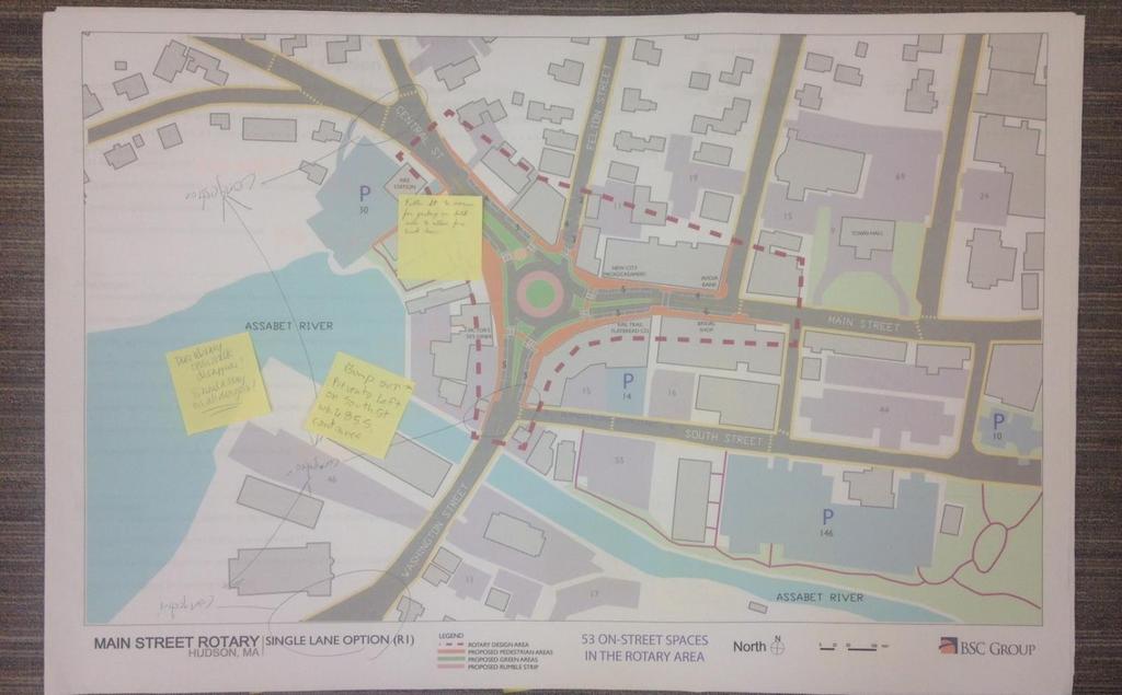
3 Disadvantages: - removes the rotary as an iconic feature of the downtown - 9 dots - results in decreased capacity and increased vehicle queues compared to existing conditions - 1 dot - increases vehicle delays as a result of restrictions to free flow movements - 2 dots - does not reduce conflict types or improve the crash severity - 8 dots - OTHER DISADVANTAGES: (additional public input) o Space for bike lanes - 4 dots o It wouldn t be much of a Rotary project within no rotary would it? o No o No traffic lights o Don t like to lose the Rotary o Bump outs maintenance nightmare o Too many lefts o What about Felton Street? 2 choices now/only one choice (with this option) o Most expensive option - 4 dots 2. Single Lane Option (R1) Key Features Include: - 53 on-street parking spaces - 5 dots - Opportunities for streetscape beautification and landscaping - 1 dot - Improved pedestrian conditions - Maintaining the Rotary within the Downtown - 7 dots - OTHER KEY FEATURES: (additional public input) o Does library crosswalk disappear? Should stay on all designs! Advantages: - enhances pedestrian safety by minimizing the number of travel lanes and reducing the overall crossing distance 5 dots - increases pedestrian visibility with raised crosswalks and well-defined pedestrian spaces - 3 dots - provides opportunities to use rotary as a way to make Downtown unique 4 dots - provides opportunities for landscaping and other attractive features 3 dots - reduces travel speeds through and into the intersection - improves intersection safety by reducing conflict points and crash severity 9 dots - reduces vehicle delay, even in night time conditions - additional traffic islands will result in traffic calming 3 dots - OTHER ADVANTAGES: (additional public input) o Yes best Disadvantages: - results in long queues during portions of the peak hour as a result of a single travel lane - queuing of vehicles extends past Fire Station in AM and PM - potential for sign pollution from pedestrian crossing signs and rotary directional signs 2 dots - no large contiguous pedestrian/green space
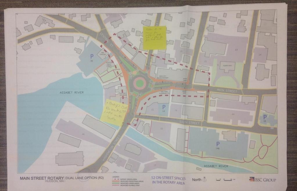
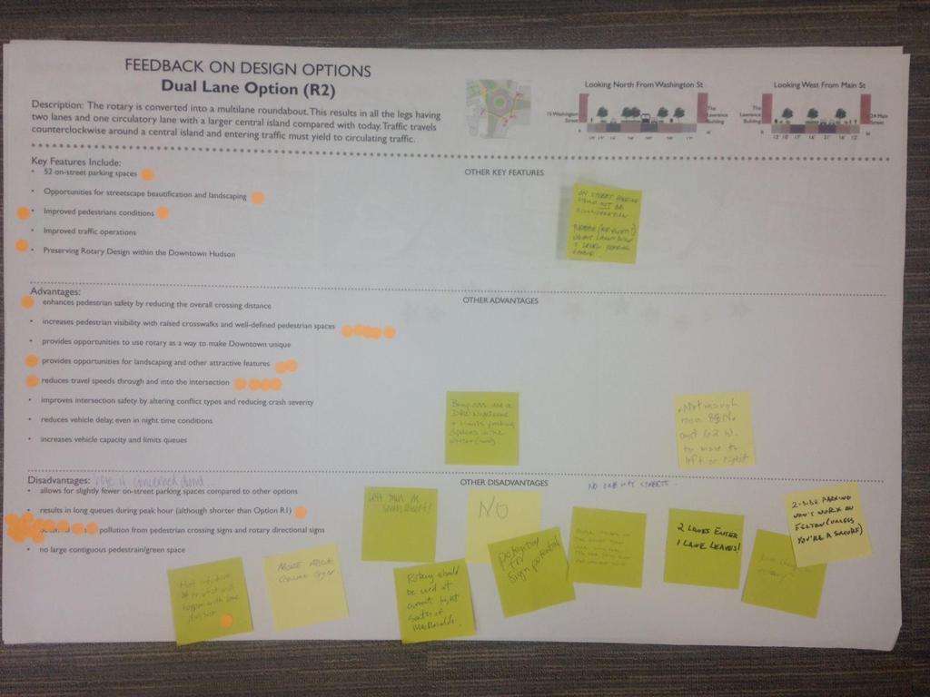
4 - OTHER DISADVANTAGES: (additional public input) o Should look at queuing with fully built out Highland Commons o Felton street not wide enough to park on both sides o Left turn on South Street o Bikes have to enter traffic lane as it narrows. How is that marked for traffic and bikes? o Retain rotary s simple design o Bump out prevents left on South St while 85 South continues o Felton street to narrow for parking on both sides to allow sire truck down 3. Dual Lane Option (R2) Key Features Include: - 52 on-street parking spaces - 1 dot - Opportunities for streetscape beautification and landscaping - 1 dot - Improved pedestrian conditions - 2 dots - Improved traffic operations - Preserving Rotary Design within the Downtown Hudson - 1 dot - OTHER KEY FEATURES: (additional public input) o On street parking should not be a consideration. Purchase (air-right?) vacant Land and build 2 level parking garage. Advantages: - enhances pedestrian safety by reducing the overall crossing distance - 1 dot - increases pedestrian visibility with raised crosswalks and well-defined pedestrian spaces - 5 dots - provides opportunities to use rotary as a way to make Downtown unique - provides opportunities for landscaping and other attractive features - 3 dots - reduces travel speeds through and into the intersection - 5 dots - improves intersection safety by altering conflict types and reducing crash severity - reduces vehicle delay, even in night time conditions - increases vehicle capacity and limits queues - OTHER ADVANTAGES: (additional public input) Disadvantages: - allows for slightly fewer on-street parking spaces compared to other options - results in long queues during peak hour (although shorter than Option R1) - 1 dot - potential for sign pollution from pedestrian crossing signs and rotary directional signs - 12 dots - no large contiguous pedestrian/green space - OTHER DISADVANTAGES: (additional public input) o Bump puts are a DPW nightmare and limits parking spaces in the winter (snow) o Not enough room 85 North and 62 West to move to left or right o Not intuitive to what will happen with land division - 1 dot o More about ground sign o Left turn on South Street! o No o Rotary should be used at current light South of McDonalds o Potential for sign
 o Lane change in Rotary o Bump out prevents")
 9 stars Dual Lane Option (R2) - 5 starts Media Coverage:")
5 Preferred Design Option o People drive in the right turn lane, will not yield o 2 lanes enter, 1 lane leaves! o 2 side parking won t work on Felton (unless you re a smurf) o Lane change in Rotary o Bump out prevents lefts on to South Street o Felt Street to narrow for parking on both sides and to allow for fire trucks T-Intersection - 1 star Single Land Option (R1) 9 stars Dual Lane Option (R2) - 5 starts Media Coverage: Event Photos:


6 Sign-In Sheet: Feedback on Design Options:

7
8


9 Section of Favorite Concept Design:
HUDSON, MA PUBLIC FEEDBACK SUMMARY First Public Meeting September 7, :30pm Registration - 7:00-8:30pm Event
 MAIN STREET ROTARY HUDSON, MA PUBLIC FEEDBACK SUMMARY First Public Meeting September 7, 2016-6:30pm Registration - 7:00-8:30pm Event The First Public Meeting for the redesign of the Main Street Rotary
Public Information Centre
 WELCOME Public Information Centre Father Tobin Road Lougheed Middle School - Library Wednesday November 7, 2012 7:00 p.m.to 9:00 p.m. Please sign in Neighbourhood Traffic Calming Guide Background The City
2014/2015 BIKE ROUTE PLAN 83 AVENUE PROTECTED BIKE LANE
 About the Project 2014/2015 BIKE ROUTE PLAN The City of Edmonton is planning a major bike route on the south side of Edmonton. This bike route is one part of a plan to provide citizens with transportation
Bicycle Facilities Planning
 Bicycle Facilities Planning Overview Types of Cyclists Purpose for Riding Types of Facilities Bike Lanes Bicycle Boulevards Cycle Tracks Intersections Signals Signing and Marking Discussion Types of Bicyclists
WELCOME. Purpose of the Open House. Update you on the project. Present a draft recommended plan. Receive your input
 WELCOME Purpose of the Open House The Town of Smiths Falls has initiated the Beckwith Street Redevelopment Plan that includes the preparation of a streetscape functional design for the renewal of Beckwith
2014/2015 BIKE ROUTE PLAN 83 AVENUE PROTECTED BIKE LANE
 About the Project The City of Edmonton is planning a major bike route on the southside of Edmonton. The Strathcona Bike Route will connect the communities of Strathcona, Garneau and the University area,
WELCOME Public Information Centre
 WELCOME Public Information Centre Fernforest Drive Brampton Soccer Centre Community Room #2 Tuesday January 19, 2016 6:30 p.m.to 9:00 p.m. Please sign in Neighbourhood Traffic Calming Guide Background
Memo. Ocean Avenue Corridor Design Project Public Workshop #2 Summary
 Ocean Avenue Corridor Design Project Public Workshop #2 Summary The second public workshop for the Ocean Avenue Corridor Design Project was held on Wednesday, May 14, 2014 from, 6 to 8 pm at Lick Wilmerding
El Centro Mobility Hub
 The El Centro drive shed comprises a major portion of the El Centro downtown area, which is well served by bus routes. The proposals intend to promote use of public transit through improvements and enhancements
York Boulevard Streetscape Master Plan
 York Boulevard Streetscape Master Plan October 24 th, 2008 The Story of York Boulevard Streetscape Master Plan Design. Chapter 126 Dealing with Engineers. 2 1 Today s Presentation Topics: 1. Show the streetscape
Intersection Improvement: Sturgeon Road, Silver Avenue and Murray Park Road Roundabout. Welcome. Public Information Session
 Intersection Improvement: 1 Welcome WHY IS AN INTERSECTION IMPROVEMENT NEEDED? 2 Traffic volumes for Sturgeon Road, Silver Avenue and Murray Park Road exceed the capacity of the existing 4-way stop controlled
City of Wausau Wausau Center Urban Design and Transportation Master Plan. Design Workshop // October 18, 2018
 City of Wausau Wausau Center Urban Design and Transportation Master Plan Design Workshop // October 18, 2018 Design Workshops // October 15-18 Workshop Study Evaluate circulation and parking patterns around
Appendix C. TRAFFIC CALMING PROGRAM TOOLBOX
 Appendix C. TRAFFIC CALMING PROGRAM TOOLBOX PHASE I...2 Do Not Enter Sign...3 One-Way Sign...4 Turn Prohibition...5 Pavement Markings...6 Speed Monitoring Trailer...7 Neighborhood Speed Watch...8 Police
El Camino Real Specific Plan. TAC/CAC Meeting #2 Aug 1, 2018
 El Camino Real Specific Plan TAC/CAC Meeting #2 Aug 1, 2018 Land Use Alternatives Goals and Tradeoffs Parks & open space Housing Retail & services Civic spaces Parking Community gathering spaces 3 Alternatives
Edenbrook Hill Drive Traffic Calming Study
 WELCOME Public Information Centre Edenbrook Hill Drive Traffic Calming Study Fletchers Meadow Secondary School Wednesday January 20, 2016 6:30 p.m.to 9:00 p.m. Please sign in Neighbourhood Traffic Calming
Winnipeg Walk Bike Projects Downtown Tire Talk - Summary
 Winnipeg Walk Bike Projects Downtown Tire Talk - Summary Downtown Projected Bike Lane System Connecting The Forks to the Exchange District (Fort Street, Garry Street & The Forks to Assiniboine Connection)
CR 30 / CR 11 and CR 30 / CR 11C Intersection Improvement Project. What Should We Build?
 CR 30 / CR 11 and CR 30 / CR 11C Intersection Improvement Project What Should We Build? Background CR 11 (Timberline) Donath Lake CR 30 CR 11C Stop controlled intersections Currently long delays (several
Merrick and Memorial Neighborhood Study 5/14/2014 Public Meeting
 Merrick and Memorial Neighborhood Study 5/14/2014 Public Meeting Study Area April 9 Public Meeting Comments Summary Pedestrian Safety - A Walking Neighborhood Pedestrian traffic is very difficult A need
Mission-Geneva Transportation Study Community Workshop 2 July 8, 2006
 Community Workshop 2 July 8, 2006 Small Group Workbook 1 Basic Improvements on Mission Street Streetscape. Pedestrian-scale lighting; landscaping; community art on utility boxes; more (possibly unique)
Bicycle and Pedestrian Advisory Committee (BPAC) November 21, 2013
 November 21, 2013") Bicycle and Pedestrian Advisory Committee (BPAC) November 21, 2013 OVERALL LAND USE CONCEPT Overall Broadway Valdez District: 95.5 acres (35.1 acres right-of ways + 60.4 acres developable land) Plan Subareas:
Bicycle and Pedestrian Advisory Committee (BPAC) November 21, 2013 OVERALL LAND USE CONCEPT Overall Broadway Valdez District: 95.5 acres (35.1 acres right-of ways + 60.4 acres developable land) Plan Subareas:
EXECUTIVE SUMMARY. Vision
 Vision Walking and bicycling in Salt Lake City will be safe, convenient, comfortable, and viable transportation options that connect people to places, foster recreational and economic development opportunities,
Introduction. North 12 th Complete Street Project Overview
 Introduction On Wednesday, March 1, 2017, the City of Sacramento, in partnership with Sacramento Regional Transit District and the Sacramento Housing and Redevelopment Agency, hosted a community outreach
BETHEL ROAD AND SEDGWICK ROAD CORRIDOR STUDY
 DRAFT PLAN City Council Meeting August 14, 2017 STUDY AREA Sedgwick Corridor State Route 160, principal arterial with Class 3 access management designation, commuter and freight route, connection to SR
City of Ann Arbor Pedestrian Safety & Access Task Force
 City of Ann Arbor Pedestrian Safety & Access Task Force (PSATF) Community Wide Meeting Wednesday, July 8th 6:30 to 8:30 PM Multi purpose Room, Downtown Library www.a2gov.org/pedsafety The Greenway Collaborative,
Cycle Track Design Best Practices Cycle Track Sections
 Design Best Practices Sections It is along street segments where the separation and protection methods of cycle tracks offer more comfort than conventional bicycle lanes, and are more attractive to a wide
A CHANGING CITY. of Edmonton, it is essential that it reflects the long-term vision of the City.
 A CHANGING CITY By the year 2040, Edmonton will be home to more than 1 million people. To accommodate growth and support a healthy and compact city, we need a new approach to development/redevelopment
Design Public Hearing MassDOT Project # February 19, 2015 Chatham Town Hall Annex 7:00 P.M.
 Design Public Hearing MassDOT Project #606596 February 19, 2015 Chatham Town Hall Annex 7:00 P.M. Overview Process to date Project goals Data collection results Existing conditions Alternative analysis
FOCUS AREA 1 - Alberta Avenue Pocket Park 3 (121 Ave and 92 St)
") FOCUS AREA 1 - Alberta Avenue Pocket Park 3 (121 Ave and 92 St) New benches Plant evergreen trees Widen existing sidewalk from 1.5m to 1.8m Marked crosswalk 1.8m wide sidewalk Add pedestrian oriented lights
FOCUS AREA 1 - Alberta Avenue Pocket Park 3 (121 Ave and 92 St) New benches Plant evergreen trees Widen existing sidewalk from 1.5m to 1.8m Marked crosswalk 1.8m wide sidewalk Add pedestrian oriented lights
TRAFFIC CALMING TOOLBOX. For the residents of the City of Decatur, Georgia
 TRAFFIC CALMING TOOLBOX For the residents of the City of Decatur, Georgia 2 City of Decatur Traffic Calming Toolbox Public Works Department 2635 Talley Street Decatur, GA 30030 404.377.5571 3 Welcome to
Simulation Analysis of Intersection Treatments for Cycle Tracks
 Abstract Simulation Analysis of Intersection Treatments for Cycle Tracks The increased use of cycle tracks also known as protected bike lanes has led to investigations of how to accommodate them at intersections.
CTDOT Pedestrian and Bicycle Safety Initiatives
 CTDOT Pedestrian and Bicycle Safety Initiatives 2017 Northeast Transportation Safety Conference Mark F. Carlino, P.E. Traffic Engineering Division Chief Bureau of Engineering and Construction Connecticut
Eliminate on-street parking where it will allow for a dedicated bus only lane %
 Traffic Dashboard Priorities Survey Responses Introduction 1) Are you familiar with bus rapid transit (BRT)? a. No, BRT is new to me. 597 23.5% b. I ve heard of BRT, but I don t know much about it. 1,136
Public Workshop #2. September 14, 2016
 Public Workshop #2 September 14, 2016 Agenda Welcome Project Overview Where We Have Been Alternatives for State Street Land Use Street Design Next Steps 2 Project Overview Create a Vibrant State Street
Item to be Addressed Checklist Consideration YES NO N/A Required Description Complete Streets Guidelines
 Passaic County Complete Streets Checklist - Concept Development Project Name Item to be Addressed Checklist Consideration YES NO N/A Required Description Complete Streets Guidelines Existing Plans Have
Observations and Ideas: Toomer s Corner Streetscape Improvements
 Observations and Ideas: Toomer s Corner Streetscape Improvements AUBURN DOWNTOWN MASTER PLAN planning downtown s future August 26, 2013 Observations: Vertical Clutter at Corners 6 3 7 5 9 2 8 4 1 Excess
CLOSED. Highlights of the Final Concept Design:
 The final Concept Design is the result of many months of listening, learning, creating, balancing, and understanding different needs and viewpoints, as well as incorporating technical requirements and
By: Bill Baranowski, PE TRAFFIC CALMING EXAMPLES IN SUGARHOUSE, DAYBREAK, AND WEST JORDAN CITY
 By: Bill Baranowski, PE TRAFFIC CALMING EXAMPLES IN SUGARHOUSE, DAYBREAK, AND WEST JORDAN CITY 1977 HIGHLAND RUGBY TOUR 1945 WHERE??? What is more contentious than traffic calming? 1951 LOOKING SOUTHEAST
Monterey Road Complete Streets
 Monterey Road Complete Streets Complete Street Objectives Improve livability and economic vitality Enhance pedestrian environment Accommodate bicyclists safely Reduce noise and air pollution Create attractive,
INTERSECTION DESIGN. Bicycle Facility Workshop Intersections 4-1
 INTERSECTION DESIGN 4-1 Intersections Avoid unusual conflicts Provide direct path for cyclists, close to that of motor vehicles Bicyclists should be visible; their movements should be predictable Simple
South Park Street Bicycle Lane Improvements. Public Engagement. November 2017
 South Park Street Bicycle Lane Improvements Public Engagement November 2017 South Park Street Bicycle Lane Improvements WHAT WE HEARD REPORT Introduction To improve safety and bicycle route continuity
Frequently Asked Questions
 Frequently Asked Questions Business US 190 in Copperas Cove From Avenue D to Constitution Drive What is access management? A. Access Management is a growing effort by government agencies to improve how
City of Sammamish. Welcome. Issaquah-Fall City Road Improvements Project Phase I Design: 242nd Avenue SE to Klahanie Drive SE
 Welcome Welcome to the third community meeting for the Issaquah-Fall City Road Improvements Project. AGENDA 6:00 p.m. Welcome and sign-in 6:10 p.m. Presentation 6:50 p.m. Open house Learn about the roadway
UPTOWN REGIONAL BIKE CORRIDORS PROJECT SAN DIEGO ASSOCIATION OF GOVERNMENTS
 UPTOWN REGIONAL BIKE CORRIDORS PROJECT SAN DIEGO ASSOCIATION OF GOVERNMENTS SUMMARY REPORT: COMMUNITY UPDATE MEETING February 6, 2014 6 8:30 p.m. Roosevelt Middle School Library 3366 Park Blvd, San Diego
Community Task Force November 15, 2017
 Community Task Force November 15, 2017 Welcome and Introductions Project Partners Regional Transportation District (RTD) Colorado Department of Transportation (CDOT) Denver Regional Council of Governments
Thank you for attending
 Improving mobility safety comfort WELCOME Thank you for attending The purpose of this meeting is to: Learn about the project Prioritize potential walking and biking improvements on Snelling Ave Gather
Raymond Avenue: Rightsizing Improved Safety and Pedestrian Experience
 Page 1 of 5 Work With Us Free Newsletter Stay Connected Home About Services Training Projects Placemaking Blog Resources Reference Store Great Public Spaces Image Collection Raymond Avenue: Rightsizing
Kennedy Plaza and Providence Downtown Transit Connector PUBLIC MEETING. Stakeholder Meeting #1 October 24, 2016
 Kennedy Plaza and Providence Downtown Transit Connector PUBLIC MEETING Stakeholder Meeting #1 October 24, 2016 May 2017 1 WHAT IS THE DTC? 1.5 mile corridor between Providence Station and the Hospital
Alternative Traffic Calming Methods
 Alternative Traffic Calming Methods In-street Pedestrian Crossing Sign Cost: approximately $300 per sign not including the installation cost Advantages of in-street pedestrian crossing signs 1. Typically
City of Wilsonville 5 th Street to Kinsman Road Extension Project
 City of Wilsonville 5 th Street to Kinsman Road Walking Tour & Neighborhood Workshop Summary Report Public Outreach Overview On July 18 th, 2017, the City of Wilsonville hosted a neighborhood walking tour
THE ALAMEDA CONCEPT DESIGN COMMUNITY MEETING 3. A Plan for The Beautiful Way JANUARY 28, 2010
 CONCEPT DESIGN COMMUNITY MEETING 3 JANUARY 28, 2010 AGENDA INTRODUCTION COMMUNITY INPUT ROADWAY STUDIES STREETSCAPE DESIGN STATIONS DISCUSSION SUMMARY AND DISCUSSION NEXT STEPS CLOSE INTRODUCTION SCHEDULE
CURBSIDE ACTIVITY DESIGN
 5 CURBSIDE ACTIVITY DESIGN This chapter provides design guidance for separated bike lanes adjacent to curbside activities including parking, loading and bus stops. Typical configurations are presented
Roundabouts A Case Study and Brief Overview
 Roundabouts A Case Study and Brief Overview Presented by: Matt Loeffler, PE, Traffic Engineer, Butler County Ohio And Jack Pflum, PE, Transportation Planning Consultant At The Traffic Engineering Workshop,
Major Bike Routes 102 Avenue Workshop April 21, 2015
 Major Bike Routes 102 Avenue Workshop April 21, 2015 Our Purpose Today Provide context on how Major Bike Routes fit into Edmonton s future Share information on what we heard in our last phase, and how
Front and Myrtle Improvement Project
 Front and Myrtle Improvement Project MAKING BOISE THE MOST LIVABLE CITY IN THE COUNTRY DOWNTOWN: Our unique and vibrant urban neighborhood GUIDING PRINCIPLES: Innovation Celebration Transportation Downtown
Route 7 Corridor Study
 Route 7 Corridor Study Executive Summary Study Area The following report analyzes a segment of the Virginia State Route 7 corridor. The corridor study area, spanning over 5 miles in length, is a multi
Agenda. Overview PRINCE GEORGE S PLAZA METRO AREA PEDESTRIAN PLAN
 PRINCE GEORGE S PLAZA METRO AREA PEDESTRIAN PLAN May 28, 2008 Agenda Welcome and introductions Project overview and issue identification Planning context and strengths Design challenges and initial recommendations
TRAVEL PLAN: CENTRAL EUROPEAN UNIVERSITY CAMPUS REDEVELOPMENT PROJECT TRAVEL PLAN. Central European University Campus Redevelopment Project.
 TRAVEL PLAN Central European University Campus Redevelopment Project Page 1 Table of Contents Introduction... 3 Background... 7 Building Users... 7 Transportation in Community Consultation... 7 Summary
Dec 2, Dear Tri Ong, Sam Woods, and Scott Kubly,
 Dec 2, 2014 Dear Tri Ong, Sam Woods, and Scott Kubly, Thank you for providing us with the 2015 Arterial Asphalt and Concrete (AAC) repaving project 60% plan for Roosevelt Way NE. It's exciting to see the
Public Works Committee Meeting Richard E. Mastrangelo Council Chamber November 20, 2017
 Public Works Committee Meeting Richard E. Mastrangelo Council Chamber November 20, 2017 Purpose of Meeting Why are we here? Project Recap/Updates Project Limits/Segments Road Diet Concept Lessons Learned
Austin Avenue Bridges Project. Public Meeting Summary
 Austin Avenue Bridges Project Public Meeting Summary June 29, 2016 Red Table Safety and Connectivity Notes: 1. Would like to see forensic report evaluations 2. What is the lifespan? 3. Extend safety considerations
Draft North Industrial Area-Wide Traffic Plan
 Summary of North Industrial and Hudson Bay Industrial Recommended Improvements Table 1. Summary of s Item Location 1 2 3 4 5 6 7 8 9 10 11 12 Millar Ave north of 51st St Super 8 Motel back lane 400 Block
ALBERTA AVENUE WHAT WE HEARD REPORT BUILDING GREAT NEIGHBOURHOODS
 ALBERTA AVENUE WHAT WE HEARD REPORT BUILDING GREAT NEIGHBOURHOODS FEBRUARY 2019 EXECUTIVE SUMMARY Starting in 2019, Alberta Avenue will see the replacement and enhancement of its aging collector and local
$ 12" $#&%$ 86.) *1! *1 /3 )00, , (1* Neighborhood Traffic Calming Part 3 Solutions Bradley William Yarger, P.E.
 *1! *1 /3 )00, , (1* Neighborhood Traffic Calming Part 3 Solutions Bradley William Yarger, P.E.") $ 12" $#&%$ 86.)3+5+2 714 *1! *1 /3 )00,12 3.+ -0127 1, (1* Neighborhood Traffic Calming Part 3 Solutions by Bradley William Yarger, P.E. It is extremely tempting to jump to this step of the process thinking
$ 12" $#&%$ 86.)3+5+2 714 *1! *1 /3 )00,12 3.+ -0127 1, (1* Neighborhood Traffic Calming Part 3 Solutions by Bradley William Yarger, P.E. It is extremely tempting to jump to this step of the process thinking
Ocean Park Boulevard Green Street Project Alternatives & Trade Offs
 Planning Commission March 4, 2009 Ocean Park Boulevard Green Street Project Alternatives & Trade Offs Purpose of Tonight s Meeting Review concept plans and options Provide input on alternatives and trade-offs
Palou Complete Street Project Barneveld Avenue to Crisp Road Project overview and concept design Community Meeting #2 May 13, 2015
 Palou Complete Street Project Barneveld Avenue to Crisp Road Project overview and concept design Community Meeting #2 May 13, 2015 Agenda Welcome and introductions Project overview, history and goals Concept
North Shore Transportation Improvement Strategy
 North Shore Transportation Improvement Strategy Preliminary, Near-term Recommendation 2016 April Transportation Improvement Strategy (TIS) Comprehensive and Analytical A multi-modal transportation strategy
Cross Street Corridor Non-Motorized Enhancement Project Project Description
 Cross Street Corridor Non-Motorized Enhancement Project Project Description A cooperative study of the Cross Street neighborhood was completed in May 2002 by the City of Ypsilanti, the Depot Town Downtown
Sherwood Drive Traffic Circle
 Strathcona County Sherwood Drive Traffic Circle Online Survey Results April 7, 215 I. Executive Summary The Sherwood Drive Traffic Circle Survey was administered in March 215. In total, 2,263 residents
MARTIN LUTHER KING JR. WAY
 OCTOBER 2011 40 Vision and Goals The Martin Luther King, Jr. Way Illustrative Master Plan that follows has been developed through a process of community involvement. It expresses a long term vision for
Lessons Learned from Cycle Tracks (Class IV Bikeways) Design Practice
 Design Practice") Lessons Learned from Cycle Tracks (Class IV Bikeways) Design Practice By: Min Zhou, P.E., Principal/Vice President KOA Corporation 1 What is a Cycle Track (Class IV) TYPICAL BIKEWAY CLASSIFICATION CLASS
Lessons Learned from Cycle Tracks (Class IV Bikeways) Design Practice By: Min Zhou, P.E., Principal/Vice President KOA Corporation 1 What is a Cycle Track (Class IV) TYPICAL BIKEWAY CLASSIFICATION CLASS
50 Avenue S.W. Corridor Study Glenmore Aquatic Centre Drop-In Event
 Project overview The City of Calgary is conducting a transportation corridor study of 5 Avenue S.W., between Crowchild Trail and 4A Street S.W. In 29, it was reclassified as a Parkway under the Calgary
Off-road Trails. Guidance
 Off-road Trails Off-road trails are shared use paths located on an independent alignment that provide two-way travel for people walking, bicycling, and other non-motorized users. Trails specifically along
PEDESTRIAN ACTION PLAN
 ATTACHMENT 2 CITY OF SANTA MONICA PEDESTRIAN ACTION PLAN CITY OF SANTA MONICA PEDESTRIAN ACTION PLAN This page intentionally left blank EXECUTIVE SUMMARY CHAPTER 1 EXECUTIVE SUMMARY Setting the Stage
Albany Shaker Road Corridor Study Public Meeting # 2
 Albany Shaker Road Corridor Study Public Meeting # 2 Scope / Meeting Purpose This project is a CDTC Linkage Study. The Linkage Program is designed to implement the adopted planning and investment principles
Riverside Drive Complete Streets Project 3 rd Community Meeting. March 26, 2015
 Riverside Drive Complete Streets Project 3 rd Community Meeting March 26, 2015 Providing Feedback Sign-In with contact information for future updates Complete questionnaire provided tonight Complete comment
STREETSCAPE CONCEPT PLAN
 03 STREETSCAPE CONCEPT PLAN Zone 1 This zone includes the gateway into both the downtown and the Village at Harlem. The gateway features are shown closer to the Harlem intersection to make them more prominent.
The Wiggle Route in Context
 The Wiggle Route in Context In a city of hills, the Wiggle is an important route because it winds its way along the flattest streets from Market to the Panhandle, bringing residents to local parks and
Atwood Avenue Fair Oaks Avenue Cottage Grove Road
 Atwood Avenue Fair Oaks Avenue Cottage Grove Road Agenda Purpose Review project scope & goals Present design alternatives Gather feedback Answer Questions Format Open House Presentation Q&A Open House
Meade Street Bridge Design Alternative Study
 Meade Street Bridge Design Alternative Study Preferred Alternative Presentation Stakeholder Meeting #3 June 23, 2011 Presented by: Dan Biggs, RLA Meeting Agenda Purpose: 1. Review Meeting #2 Feedback 2.
Tonight is for you. Learn everything you can. Share all your ideas.
 Strathcona Neighbourhood Renewal Draft Concept Design Tonight is for you. Learn everything you can. Share all your ideas. What is Neighbourhood Renewal? Creating a design with you for your neighbourhood.
Queensboro Bridge Bus Priority Study: Summary of Recommendations. Presentation to Manhattan Community Board 8 May 4, 2011
 : Summary of Recommendations Presentation to Manhattan Community Board 8 May 4, 2011 1 Overview Study Goal: Identify cost-effective ways to improve bus speed and reliability for local and express buses
Designing for Pedestrian Safety
 Designing for Pedestrian Safety Introduction to Pedestrian Safety Design and Planning Principles Presented by: Craig Allred FHWA Resource Center Technical Specialist and Michael Ronkin Owner, Designing
Southview Blvd & 3 rd Avenue Improvement Project. Public Open House December 4, to 7pm
 Southview Blvd & 3 rd Avenue Improvement Project Public Open House December 4, 2014 5 to 7pm Southview Blvd & 3 rd Avenue Public Information Meeting Agenda Presentation 5:30 to 6:15 pm Purpose of Project
Providence Downtown Transit Connector STAKEHOLDER MEETING #2. Stakeholder Meeting #1 October 24, 2016
 Providence Downtown Transit Connector STAKEHOLDER MEETING #2 Stakeholder Meeting #1 October 24, 2016 February 2017 1 AGENDA 1 DTC Goals and Expectations 2 Street Design Concepts 3 Potential Benefits and
Capital Metro Downtown Multimodal Station
 Capital Metro Downtown Multimodal Station Open House December 11, 2015 Project Goals & Objectives 1 2 3 4 Address near- and long- term MetroRail operational needs Address existing safety issues and modal
Chapter 2: Standards for Access, Non-Motorized, and Transit
 Standards for Access, Non-Motorized, and Transit Chapter 2: Standards for Access, Non-Motorized, and Transit The Washtenaw County Access Management Plan was developed based on the analysis of existing
Monroe Street Reconstruction Business Focus Group Notes July 18, 2016, HotelRED
 Monroe Street Reconstruction Business Focus Group Notes July 18, 2016, HotelRED Total participants: 31 Focus Group Conversation #1: During this exercise, participants talked in small table groups in response
CHAPTER 3: Vision Statement and Goals
 Davidson Walks & Rolls: Active Transportation Master Plan CHAPTER 3 Contents: Overview Vision Statement Measurable Goals Public Outreach CHAPTER 3: Vision Statement and Goals Overview The vision statement
Caltrans Sloat Boulevard Pedestrian Safety Project Response to Community Questions, Comments & Concerns
 Caltrans Sloat Boulevard Pedestrian Safety Project Response to Community Questions, Comments & Concerns Revised: May 10, 2016 The California Department of Transportation (Caltrans) is planning various
Vision: Traditional hamlet with an attractive business/pedestrian friendly main street connected to adjacent walkable neighborhoods
 N D. Focus Area II Vision: Traditional hamlet with an attractive business/pedestrian friendly main street connected to adjacent walkable neighborhoods Transit Road Focus Area II is located in the Hamlet
Advancing Transportation Choices in Des Moines. MPO Environmental Roundtable January 9, 2018
 Advancing Transportation Choices in Des Moines MPO Environmental Roundtable January 9, 2018 Presented by Jennifer McCoy, PE, PTOE City Traffic Engineer Agenda Des Moines Area Transportation Planning Connect
Community Task Force March 14, 2018
 Community Task Force March 14, 2018 Welcome and Introductions Project Partners Regional Transportation District (RTD) City of Aurora Colorado Department of Transportation (CDOT) Denver Regional Council
Active Transportation Facility Glossary
 Active Transportation Facility Glossary This document defines different active transportation facilities and suggests appropriate corridor types. Click on a facility type to jump to its definition. Bike
City of Elizabeth City Neighborhood Traffic Calming Policy and Guidelines
 City of Elizabeth City Neighborhood Traffic Calming Policy and Guidelines I. Purpose: The City of Elizabeth City is committed to ensure the overall safety and livability of residential neighborhoods. One
How to Develop a Pedestrian Safety Action Plan
 How to Develop a Pedestrian Safety Action Plan Course Introduction Presented by: Peter Eun FHWA RC Safety Engineer Ryan Snyder President, Ryan Snyder Associates, LLC Paul Zykofsky Director, Land Use and
League City Parkway at Brittany Lakes/Fennigan Intersection Evaluation/ Traffic Study. Second Public Meeting February 6, 2018
 League City Parkway at Brittany Lakes/Fennigan Intersection Evaluation/ Traffic Study Second Public Meeting February 6, 2018 City Project Information League City Parkway and Brittany Lakes Dr./ Fennigan
Las Tunas Downtown Revitalization City Council Study Session. December 1, :00 p.m. Live Oak Park Community Center
 Las Tunas Downtown Revitalization City Council Study Session December 1, 2015 7:00 p.m. Live Oak Park Community Center AGENDA 2 Provide downtown context. Confirm project goals. Analyze three design concepts.
Plant City Walk-Bike Plan
 Plant City Walk-Bike Plan Plant City Commute Mode Share 2.2% 1.4% 2.9% Drove alone 10.2% Carpooled Public transportation (0.1%) Walked Used a Bike (0.4%) 82.9% Taxicab, motorcycle, or other means Worked
Technical Working Group November 15, 2017
 Technical Working Group November 15, 2017 Welcome and Introductions Project Partners Regional Transportation District (RTD) Colorado Department of Transportation (CDOT) Denver Regional Council of Governments
TRAFFIC CALMING GUIDE FOR TORONTO CITY OF TORONTO TRANSPORTATION SERVICES DIVISION
 TRAFFIC CALMING GUIDE FOR TORONTO CITY OF TORONTO TRANSPORTATION SERVICES DIVISION CITY OF TORONTO TRANSPORTATION SERVICES DIVISION 2016 TRAFFIC CALMING GUIDE FOR TORONTO TABLE OF CONTENTS Introduction