2. Existing Conditions
|
|
|
- Avis Lyons
- 5 years ago
- Views:
Transcription
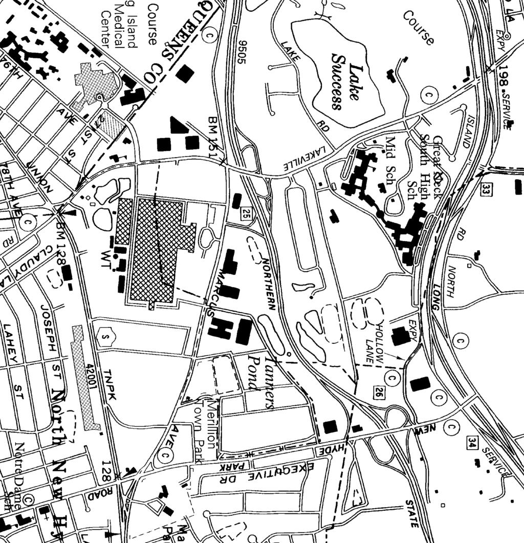
1 2. Existing Conditions The existing traffic and parking conditions on the site and the surrounding area were reviewed based on the study methodology in Section Existing Land Use The portion of the site within the Village of Lake Success is in the Economic Development A District. The remaining portion of the site is within the Town of North Hempstead in the Industrial A District. The entire building has about 1.3 million square feet of offices, warehouse space, medical offices related to the Long Island Jewish Hospital ( LIJ ), and various common areas and vacant spaces. When the 2006 traffic counts were taken, the building had 303,581 s.f. of vacant rentable space: 45,430 s.f. in the Town and 258,151 s.f. in the Village. When the September 2008 traffic counts were taken, the vacant space had increased slightly to 321,229 square feet: 278,291 s.f. in the Village and 42,938 s.f. in the Town. This site is bounded by Marcus Avenue, Lakeville Road, and Union Turnpike. The Northern State Parkway is just to the north. The majority of the surrounding area consists of offices and commercial uses, and LIJ is across the street on Lakeville Road Existing Building Uses Table 2-1 details the uses within the building in October 2008: Table 2-1: October 2008 Building Areas Lake Success Rentable Floor Area (s.f.) Gross Floor Area (s.f.) 1 General Office Non-Medical 239, ,688 NSLIJ Condominium 92, ,074 NSLIJ HR 18,577 21,423 Warehouse 9,250 10,667 Cablevision Studio 1,448 1,670 General Unoccupied 122, ,949 NSLIJ Unoccupied 156, ,984 Common Space Unoccupied 42,642 N/A Common Space 55,475 N/A Café 4,689 4,689 Lake Success Total 743, ,144 VILLAGE * rentable space: 366,736 s.f. Vacant rentable space: 278,291 s.f. Common Space: 42, ,475 = 98,117 s.f. * Village occupied rentable space = 366,736 s.f. (Total unoccupied common space) Cameron Engineering & Associates, LLP 2-1
2 Table 2-1 (continued) North Hempstead General Office Non-Medical 208, ,897 NSLIJ Condominium 74,289 79,633 Utilities 12,566 12,566 Warehouse 120, ,666 Health Club 102, ,522 NSLIJ Unoccupied 42,938 46,027 Common Space Unoccupied 3,089 N/A Common Space 29,071 N/A Café North Hempstead Total 594, ,825 TOWN ** rentable space: 519,727 s.f. Vacant rentable space: 42,938 s.f. Common Space: 3, , ,160 s.f. Total : 886,463 s.f. Total Vacant: 321,229 s.f. Grand Total 1,337,969 1,337,969 Common Space: 130,277 s.f. ** Town occupied rentable space = 519,727 s.f. (Total unoccupied common space) 1 Common Space is distributed to Gross Floor Area of uses in proportion to rentable area. 2.2 Roadway Descriptions Lakeville Road is a north-south NCDPW arterial. It has two through lanes in each direction with turning lanes at some intersections, and its posted speed limit is 40 mph. The estimated 2008 Average Daily Traffic (ADT) volume is 40,950 vehicles per day ( vpd ) in front of this site. Marcus Avenue is an east-west NCDPW arterial. Between Little Neck Parkway in Queens and Lakeville Road, it serves as a two-way frontage road for the Northern State Parkway/Grand Central Parkway. In front of the site, it generally has two through lanes in each direction with turn lanes at some intersections, and the posted speed limit is 40 mph. The estimated 2008 ADT volume east of Lakeville Road is 31,750 vpd. In front of the site, Union Turnpike ( NY Route 25C ) is an east-west State arterial with two travel lanes in each direction and additional turning lanes at some intersections. The posted speed limit in front of the site varies from 30 to 40 mph. The estimated 2008 ADT volume east of Lakeville Road is 18,310 vpd. New Hyde Park Road is a north-south NCDPW road with two to three lanes in each direction and turn lanes at key intersections. Its estimated 2008 ADT is 40,510 vpd between Marcus Avenue and Union Turnpike. The Northern State Parkway is an east-west limited access State highway that is restricted to passenger vehicles. There are three lanes in each direction and the speed limit is 55 mph. Between Exit 25 (Lakeville Road) and Exit 26 (New Hyde Park Road) the estimated Cameron Engineering & Associates, LLP 2-2
3 2008 ADT volume is 168,950 vpd. To the west, at the Nassau/Queens line, the name of the highway changes to the Grand Central Parkway. The LIE service roads are one-way roadways that front the Long Island Expressway (LIE). The North Service Road is one-way westbound, and the South Service Road is one-way eastbound. The service roads are maintained by Nassau County, but the signals at their main intersections are under the jurisdiction of the NYSDOT. At the request of the Village traffic consultant, the Applicant was asked to evaluate the potential impacts on Village roadways due to possible increases in traffic volumes generated by this project should it be approved. As described above, none of the major roadways surrounding or leading to the site are Village of Lake Success roadways. Therefore, any impact on any Village roadway that may result by the granting of this application would be negligible at best. Union Turnpike, Marcus Avenue, Lakeville Road, and New Hyde Park Road are the roads that visitors/employees to the site will utilize and none of these roads are Village of Lake Success roadways. It is not anticipated that visitors/employees to the site will utilize or negatively impact any Village roadways and thus there will be no increase in the potential costs related to the repair/maintenance requirements of such roadways as a result of the granting of this application. 2.3 Key Intersections Based on site visits, there were 15 key intersections identified: 1. Lakeville Road at the LIE North Service Road 2. Lakeville Road at the LIE South Service Road 3. Lakeville Road at Marcus Avenue 4. Marcus Avenue at the West Site Driveway/Astoria Savings Bank Driveway 5. Marcus Avenue at the East Site Driveway/Lake Success Quad Driveway 6. Marcus Avenue at New Hyde Park Road 7. Union Turnpike at New Hyde Park Road 8. Union Turnpike at the South Site Driveway 9. Union Turnpike at Lakeville Road 10. Lakeville Road at Site Driveway/North LIJ Driveway 11. Lakeville Road at Site Driveway/South LIJ Driveway 12. Lakeville Road at Great Neck Schools Driveway/Village Club Driveway 13. Lakeville Road at Lake Road 14. Lakeville Road at the Westbound Northern Parkway Exit 25 Exit/Entrance Ramps 15. Marcus Avenue at the Eastbound Northern State Parkway Exit/Entrance Ramps Table 2-2 summarizes the geometry and traffic control at each of these intersections: Cameron Engineering & Associates, LLP 2-3
4 Table 2-2: Roadway Geometry KEY: L = Left turn lane T = Through lane R = Right turn lane R* = Channelized right lane LT = Combination of left turns and through movements in one lane TR = Combination of through movements and right turns in one lane LR = Combination of left and right turns in one lane LTR = Combination of left turn, through, and right turn movements in one lane 1. Lakeville Road at LIE North Service Road: 3-phase traffic signal Dir. Lanes Width Dir. Lanes Width NB 1-L 10 feet EB 1-L 11 feet 2-T 10 feet 1-R 11 feet SB 1-T 11 feet WB 1-L 11 feet 1-TR 11 feet 2-T 12 feet 1-R 12 feet 2. Lakeville Road at LIE South Service Road: 3-phase traffic signal Dir. Lanes Width Dir. Lanes Width NB 1-T 11 feet EB 1-L 12 feet 1-TR 11 feet 2-T 12 feet 1-TR 12 feet SB 1-L 10 feet WB None 2-T 10 feet 3. Lakeville Road at Marcus Avenue: 8-phase traffic signal Dir. Lanes Width Dir. Lanes Width NB 1-L 10 feet EB 1-L 10 feet 2-T 11 feet 2-T 12 feet 1-R* 10 feet 1-R* 16 feet SB 1-L 10 feet WB 2-L 10 feet 1-T 11 feet 2-T 12 feet 1-TR 10 feet 1-R* 16 feet 4. Marcus Avenue at West Site Driveway/Astoria Bank Driveway: 2-phase Traffic Signal Dir. Lanes Width Dir. Lanes Width NB 1-LTR 13 feet SB 1-LTR 16 feet EB 1-L 11 feet WB 1-L 11 feet 1-T 13 feet 1-T 15 feet 1-TR 12 feet 1-TR 12 feet *Note: For the purposes of this study, the southbound approach was analyzed as a southbound right turn lane in all scenarios. This driveway has been closed for several years, and no traffic was observed exiting from this approach. Due to program limitations of Synchro, analyzing the approach as a LTR lane does not accurately reflect what is occurring in the field. Analyzing the approach as an exclusive right turn lane provides results more in line with what was observed. Cameron Engineering & Associates, LLP 2-4
5 Table 2-2(continued) 5. Marcus Avenue at East Site Driveway/Lake Success Quad Driveway: 3-phase traffic signal Dir. Lanes Width Dir. Lanes Width NB 1-LT 12 feet SB 1-LT 14 feet 1-R 12 feet 1-R 12 feet EB 1-L 10 feet WB 1-L 12 feet 1-T 12 feet 1-T 13 feet 1-TR 12 feet 1-TR 12 feet 6. Marcus Avenue at New Hyde Park Road: 6-phase traffic signal Dir. Lanes Width Dir. Lanes Width NB 1-L 10 feet EB 1-L 11 feet 2-T 10 feet 1-LT 11 feet 1-R* 10 feet 1-T 11 feet 1-R 11 feet SB 1-L 11 feet WB 1-T 11 feet 2-T 11 feet 1-TR 11 feet 1-R* 14 feet 1-R 10 feet 7. Union Turnpike at New Hyde Park Road: 6-phase traffic signal Dir. Lanes Width Dir. Lanes Width NB 1-L 10 feet EB 1-L 12 feet 1-T 10 feet 1-T 12 feet 1-TR 10 feet 1-TR 12 feet SB 1-L 10 feet WB 1-L 12 feet 1-T 10 feet 2-T 12 feet 1-TR 10 feet 1-TR 12 feet 8. Union Turnpike at South Site Driveway: flashing signal (stop control) Dir. Lanes Width Dir. Lanes Width NB None EB 1-LT 11 feet 1-T 11 feet 1-R 11 feet SB 1-LT 12 feet WB 1-LT 11 feet 1-R 12 feet 1-T 11 feet 1-TR 11 feet 9. Union Turnpike at Lakeville Road: 4-phase traffic signal Dir. Lanes Width Dir. Lanes Width NB 1-L 10 feet EB 1-L 10 feet 2-T 11 feet 2-T 10 feet 1-R 11 feet 1-R 10 feet SB 1-L 11 feet WB 1-L 11 feet 1-T 13 feet 2-T 11 feet 1-TR* 16 feet 1-R 10 feet Cameron Engineering & Associates, LLP 2-5
6 Table 2-2(continued) 10. Lakeville Road at Site Driveway/North LIJ Driveway: 4-phase traffic signal Dir. Lanes Width Dir. Lanes Width NB 1-L 10 feet EB 1-LT 10 feet 1-T 12 feet 1-R 10 feet 1-TR 12 feet SB 1-L 10 feet WB 1-L 11 feet 1-T 12 feet 1-T 11 feet 1-TR 12 feet 1-R 11 feet 11. Lakeville Road at Site Driveway/South LIJ Driveway: 3-phase traffic signal Dir. Lanes Width Dir. Lanes Width NB 1-L 10 feet EB 1-LT 11 feet 2-T 12 feet 1-R 12 feet 1-R 10 feet SB 1-L 10 feet WB 1-LTR 11 feet 2-T 12 feet 1-R 12 feet 12. Lakeville Road and Village Club Driveway/Great Neck Schools Driveway: 3-phase traffic signal Dir. Lanes Width Dir. Lanes Width NB 1-LT 11 feet EB 1-L 11 feet 1-TR 11 feet 1-TR 11 feet SB 1-LT 11 feet WB 1-L 11 feet 1-TR 11 feet 1-TR 11 feet (with flare) 13. Lakeville Road and Lake Road: 2-phase traffic signal Dir. Lanes Width Dir. Lanes Width NB 1-LT 10 feet EB 1-LR 16 feet 1-T 10 feet SB 1-T 10 feet WB None 1-TR 10 feet 14. Lakeville Road at Northern Parkway Entrance/Exit 25N Ramps: unsignalized merges Dir. Lanes Width Dir. Lanes Width NB 2-T 12 feet Each entrance ramp is 20 feet wide and yields to the Parkway Each exit ramp is at least 14 feet wide, stop sign-controlled, and yields to Lakeville Road SB 2-T 13 feet 15. Marcus Avenue at Northern Parkway Exit 25S: 3-phase traffic signal Dir. Lanes Width Dir. Lanes Width NB None EB 2-L 10 feet 2-T 10 feet SB 2-L 11 feet WB 2-T 12 feet 1-R 16 feet 1-R 16 feet 2.4 Traffic Volumes Most of the traffic counts taken in 2006 for the original (March 2007) version of this report Cameron Engineering & Associates, LLP 2-6
7 were re-used, while some specific locations were re-counted in September 2008 at the request of the Village traffic engineer (RMS Engineering) to confirm the validity of the data. All counts used in this traffic study reflect individual intersection peak hours as opposed to the peak of the entire network of intersections taken as a whole November 2006 Traffic Counts Traffic volumes were counted at the study intersections during typical weekday A.M., Midday, P.M., and Saturday midday peak periods on the following days: Saturday, November 18, 2006 (11:00 am to 3:00 pm) Tuesday and Wednesday, November 28 and 29, 2006 (7:00-9:00 am, 11:00 am- 1:00 pm, and 4:00-6:00 pm) * Note: Thanksgiving was on Thursday, November 23, September 2008 Traffic Counts At the request of the Village traffic engineer, more recent traffic counts were collected at the site s five (5) driveways and at the intersection of Marcus Avenue and Lakeville Road on the following days: Monday and Tuesday, September 9 and 10, 2008 (7:00-9:00 am, 11:00 am-1:00 pm, and 4:00-6:00 pm) Saturday, September 13, 2008 (11:00 am to 2:00 pm) The September 2008 counts were then compared to the corresponding November 2006 traffic counts. Overall, the 2008 and 2006 volumes were comparable (i.e. within 2% of each other). Therefore, as agreed to during discussions with the Village traffic engineer, this study uses the newer 2008 counts at the six new-count intersections, and the original November 2006 traffic counts at the nine remaining locations. This methodology yields the most conservative base traffic counts Vehicle Classification Most of the traffic counts did not need to be classified according to whether each vehicle was a car, truck, or bus. However, six intersections counted in 2006 included specific counts of heavy vehicles (vehicles with more than 6 wheels) because their truck-and-bus traffic during at least one peak hour is known to exceed 2 percent. Those intersections are: Cameron Engineering & Associates, LLP 2-7
8 Lakeville Road at the LIE North Service Road (directly affected by the LIE, which allows truck traffic, whereas the Northern State Parkway does not) Lakeville Road at the Great Neck Schools driveway (significant school bus volume) Lakeville Road at Lake Road (near the schools significant school bus volume) Marcus Avenue at New Hyde Park Road (along the N25 and N26 bus routes) Lakeville Road at Union Turnpike (along the N25 and N26 bus routes) Lakeville Road at Marcus Avenue* (along the N25 and N26 bus routes) * Note: The 2008 counts were used with its vehicle classification data from 2006 Table 2-3 on the next page illustrates the heavy vehicle percentages counted on each approach at these six intersections. Any counted percentage other than the Synchro program s 2% default heavy vehicle percentage was input manually. Also, at the Northern State Parkway ramps on Lakeville Road and Marcus Avenue, all movements onto and off the Parkway were given 0% heavy vehicles because trucks are not allowed to use the Northern State Parkway. Cameron Engineering & Associates, LLP 2-8
9 Table 2-3: Heavy Vehicle Percentages AM: 8:00-9:00 PM: 5:00-6:00 MID and SAT: 12:00-1:00 PM AM MID PM SAT Adjusted Existing Volumes Truck/Bus Volumes Heavy Vehicle % (by approach) PHF PHF PHF PHF Dir. Mvmt. AM MID PM SAT AM MID PM SAT AM MID PM SAT INTERSECTION: Lakeville Road and LIE North Service Road NB Left Thr % 5% 2% 1% SB Thr Right % 7% 6% 3% EB Left Right % 4% 10% 1% WB Left Thr % 6% 1% 2% Right INTERSECTION: Lakeville Road and Marcus Avenue NB Left Thr % 4% 2% 1% Right SB Left Thr 1, % 4% 3% 0% Right EB Left Thr % 2% 1% 1% Right WB Left Thr % 2% 1% 1% Right INTERSECTION: Lakeville Road and Great Neck Schools Driveway NB Left Thr % 1% 0% 0% Right SB Left Thr 1, , % 0% 2% 0% Right EB Left Thr % 0% 0% 0% Right WB Left Thr % 3% 4% 3% Right INTERSECTION: Lakeville Road and Lake Road NB Left Thr % 7% 4% 2% SB Thr 1, , Right % 6% 5% 2% EB Left Right % 12% 0% 0% INTERSECTION: New Hyde Park Road and Marcus Avenue NB Left Thr 1, % 7% 3% Right SB Left Thr , % 6% 2% Right EB Left Thr % 3% 2% Right WB Left Thr % 6% 1% Right INTERSECTION: Lakeville Road and Union Turnpike NB Left Thr % 4% 2% 0% Right SB Left Thr % 4% 2% 2% Right EB Left Thr % 4% 3% 2% Right WB Left Thr % 1% 0% 1% Right Cameron Engineering Associates, LLP
10 2.5 Seasonal Adjustment The March 2007 version of this study included seasonal count adjustments of ±5% for some intersections. The Village traffic engineer has since recommended that the use of seasonal adjustment factors is not necessary. Therefore, the counted volumes, shown in Figure 2-2 through Figure 2-5, are the Existing Volumes. 2.6 Existing Site Traffic Generation The Village traffic engineer has recommended that this office use the 2008 driveway counts to determine the site s existing trip generation rate in terms of trips per 1,000 square feet based on the 971,009 gross s.f. developed when the counts were performed. The Village traffic engineer also requested that these results be compared with the calculations of the Institute of Transportation Engineers (ITE) Trip Generation manual (8 th Edition): Table 2-4: 2008 Observed Site Trips and Trip Rates Trips AM MID PM SAT Trips per 1,000 s.f. AM MID PM SAT In 1, In Out Out Total 1,372 1,005 1, Total Table 2-5: ITE Trip Generation for Existing Site Building Use Gross AM Peak Hour Midday Peak Hour* PM Peak Hour Sat. Peak Hour Floor Area (s.f.) Enter Exit Total Enter Exit Total Enter Exit Total Enter Exit Total General Office 500, NSLIJ Uses 208, Warehouse 140, Cablevision Studio 1, Health Club 102, Utilities 12, Café 5, Vacant 366, Total , , , ,234 1,337,969 Counted Totals 1,372 1,005 1, * The ITE manual has no midday data, so Saturday data was applied to the midday peak hour. Based on these results, ITE trip generation data yields very similar results for AM peak hour trips, but the ITE manual significantly over-estimates the remaining three peak hours (by %). 2.7 Parking Existing Granted Reductions The Village Board of Trustees resolution states that the main building should have a Cameron Engineering & Associates, LLP 2-10
11 breakdown of 50 percent office space, and 50 percent telecommunications space, studios, warehouse/distribution space in the Village section of the Building, where the parking demand does not exceed one space per 1,000 s.f. during weekdays between 9:00 am and 5:00 pm. The resolution goes on to cite a granted parking reduction, such that, there will be 1,707 paved parking spaces and 558 land-banked parking spaces within the part of the property in the Village. Based on the typical 1 space per 150 rentable square feet Village requirement, the Village parking reduction (excluding common area and café) is equal to: Village required parking = 4,269 spaces Approved number of spaces = 1,707 paved land-banked = 2,265 spaces Granted reduction = 4,269 spaces 2,265 spaces = 2,004 spaces The Town of North Hempstead Board of Zoning Appeals Notice of Decision, dated February 13, 2002, states that a variance was granted based on the current approved site plan (dated May 2001). As noted on the site plan, the Town variance is equal to: Town required parking = 2,861 spaces Approved number of spaces = 1,465 paved + 88 land-banked = 1,553 spaces Granted reduction = 2,861 spaces 1,553 spaces = 1,308 spaces The site s total variance is (2, ,308) = 3,312 spaces Note that the existing site has been modified since the original site plan approval. The current on-site parking layout contains 4,120 parking spaces (3,474 paved and 646 landbanked), an additional 302 parking spaces compared to the approved site plan. 2.8 Parking NSLIJ Lease Agreement Based on the lease agreement with NSLIJ, 1,830 total parking spaces should be allocated to NSLIJ. Note: This provision is entirely driven by NSLIJ s lease needs and the NSLIJ desire to not give up the right to approximately 1,830 parking spaces. This provision is not at all driven by genuine parking needs. As will be discussed later in this report, non-nslij tenants will utilize parking outside the NSLIJ lease-allotted areas. All spaces allotted to NSLIJ will be available (though not needed) for NSLIJ use. 2.9 Parking 2006 Observations The current approved site plan (dated May 2001) indicates 3,818 parking spaces (3,172 paved and 646 land-banked). On-site hourly parking counts for the March 2007 version of this report were performed in December 2006 to gauge existing peak parking demand and Cameron Engineering & Associates, LLP 2-11
12 the time at which the peak demand typically occurs. The counts were conducted on two days: Saturday, December 2, 2006 from 9:00 am 3:00 pm Tuesday, December 5, 2006 from 9:00 am 5:00 pm At the time, the peak parking demand occurred at 11:00 am on both the weekday and the weekend. As a percentage of the 3,167 counted paved spaces at that time (5 fewer than shown on the site plan, a negligible difference), the 2006 results were as follows: Table 2-6: 2006 Peak Observed Parking Demand Weekday Weekend (Saturday) Peak Parking 2,622 spaces 712 Peak Occupancy 83% 22% This indicates that peak demand is significantly higher on weekdays than on weekends, and that the supply of parking spaces was more than adequate for 2006 conditions Parking 2008 Observations As requested by the Village traffic engineer, parking data was recollected in September 2008 on three days chosen to include the peak activity at LIJ (Tuesday, Wednesday, and Thursday, based on discussions with LIJ representatives). Saturday parking needs are much smaller, but were spot-checked to ensure no significant changes from The studies were conducted during the following times: Tuesday, September 16, 2008 from 9:00 am 5:00 pm Wednesday, September 17, 2008 from 9:00 am 5:00 pm Thursday, September 18, 2008 from 9:00 am 5:00 pm Saturday, October 4, 2008 (spot check at 11:00 am only, the 2006 peak time) Whereas the 2006 counts were collected at hourly (60-minute) intervals, the 2008 parking counts were done at 20-minute intervals. The 2008 counts were then compared to the 3,474 striped spaces this office counted on-site in September 2008, to calculate the overall occupancy of the site. The number of striped spaces was later verified based on an aerial image of the site taken in August In 2008, the peak weekday demand was observed at roughly the same time each day: 10:20 or 10:40 am, which is very consistent with the 2006 observations. Saturday parking was again small compared to weekdays: 460 occupied spaces. The new data indicates the same results as the 2006 data: weekday demand far exceeds Saturday demand, and the existing number of spaces is more than adequate for the existing parking demand. This is illustrated in Figure 2-1 on the following page: Cameron Engineering & Associates, LLP 2-12
13 Figure 2-1: Existing 2008 Weekday Parking Demand 3,500 3,250 Paved Parking (3,474) 3,000 Parked Vehicles 2,750 2,500 2,250 2,225 2,000 1,750 1,500 9:00 AM 9:20 AM 9:40 AM 10:00 AM 10:20 AM 10:40 AM 11:00 AM 11:20 AM 11:40 AM 12:00 PM 12:20 PM Time of Day 12:40 PM 1:00 PM 1:20 PM 1:40 PM 2:00 PM 2:20 PM 2:40 PM 3:00 PM 3:20 PM 3:40 PM 4:00 PM 4:20 PM 4:40 PM Tuesday Parking Counts Wednesday Parking Counts Thursday Parking Counts Paved Parking (3,474) As was done with trips, our engineers utilized the parking counts to determine the site s existing parking rate compared to the 971,009 gross s.f. occupied when the counts were performed. These results were then compared with the calculations of the ITE Parking Generation manual (3 rd Edition), shown in Table 2-7 and Table 2-8: Table 2-7: 2008 Observed Parking Demand and Parking Rates Peak Parking Tues Wed Thu Sat Time 10:20 10:40 10:20 11:00 971,009 gross s.f. overall Demand 2,160 2,225 2, Peak Rate: Rate spaces per 1,000 gross s.f. Village Peak Tues Wed Thu Sat Time 1:00 11:00 3:20 11:00 366,736 rentable s.f. in Village Demand Peak Rate: Rate spaces per 1,000 rentable s.f. The overall weekday observations were very similar (within 3% of each other). The peak observed rate of 2.29 spaces per 1,000 gross square feet overall corresponds to 1 space per 437 gross square feet. The approximate parking occupancy within the Village* is 2.63 spaces per 1,000 rentable square feet, which corresponds to 1 space per 380 rentable square feet. This is approximately 61 percent less than the typical Village code requirement of 1 space per 150 Cameron Engineering & Associates, LLP 2-13

14 rentable square feet. * The boundary between the Village of Lake Success and the Town of North Hempstead is a diagonal, non-physically delineated line which dissects the 1111 building and the parking lot. There was no way to consistently classify parking spaces in the field as being within the Village or the Town. The dashed blue line in the figure below illustrates the Village-Town boundary (parking section labels relate to the charts in Table 2-9). While most sections are fully within the Village or fully within the Town, two sections are bisected by the municipal boundary, so their Villageportion occupancies were estimated. The sections classified as being within the Village, and necessary Village-portion estimates, are shown below: West: All of Sections W1 and W2* * A small part of W2 (shown hatched) is outside the Village. The applicant believes it is conservative to assign all occupied W2 spaces to the Village. North: All of Sections N1, N2, N3, and N4, plus 75 percent of N5* * The eastern part of N5 (hatched) is outside the Village. The applicant believes it is conservative to assign 75% of occupied and provided N5 spaces to the Village. Section N5 area within the Village Section N5 area outside the Village Cameron Engineering & Associates, LLP 2-14
15 Table 2-8: ITE Parking Generation for Existing Site Building Use ITE Land Use Code Area (gross s.f.) ITE Calculations Based on: General Office 701 (Office Building) 500,585 1,285 Equation 2.51x + 27 NSLIJ Condominium 720 (Medical Office) 186, Equation 3.49x - 1 NSLIJ HR 720 (Medical Office) 21, Equation 3.49x Warehouse 150 (Warehouse) 140, Equation 0.41x - 5 Cablevision Studio 701 (Office Building) 1,670 5 *85 th % Rate: 2.95/ksf Health Club 492 (Health/Fitness 102, x + 27 Utilities None 12,566 0 NA Café & Vacant None 372,163 0 NA Total 1,337,969 2,467 Counted Totals Peak: 2,225 (-10.9%) * The ITE Parking Generation manual does not have the same breadth of land uses as the Trip Generation manual. While the Cablevision studio could be analyzed with its most appropriate land use code (714, Single Tenant Office) for trips, the only way to project ITE parking recommendations is to use land use code 701 (Office Building). Given its small size, the equation used for the true general office space would yield an overly conservative projection of 44 spaces. For the purposes of this exercise comparing actual parking demand to ITE projections the applicant believes it is slightly conservative to use the ITE 85 th percentile rate that yields a smaller ITE calculation. The difference between this site and ITE projections is 10.9%; the ITE Parking Generation manual conservatively estimates parking demand for this property. Table 2-9 and Table 2-10 follow on the next pages and detail the weekday parking counts. Cameron Engineering & Associates, LLP 2-15
16 FIELD DATA PROJECT 1111 Marcus Avenue CE 1334A North LOCATION Southeast corner of Marcus Avenue & Lakeville Road, Lake Success South East DATE DAY West 09/16/08 TUE COUNT STARTED MARKED SECTION SPACES 9:00 AM 9:20 AM 9:40 AM 10:00 AM 10:20 AM 10:40 AM 11:00 AM 11:20 AM 11:40 AM 12:00 PM 12:20 PM 12:40 PM 1:00 PM N N N N N TOTAL (N) E E E TOTAL (E) S S S S S TOTAL (S) W W TOTAL (W) TOTAL ,663 1,851 2,061 2,130 2,163 2,121 2,084 2,084 2,071 2,039 1,488 1,465 1,974 1,947 1,931 1,957 1,932 1,530 1,909 1,898 1,869 1,834 1,735 1,586 1:20 PM 1:40 PM 2:00 PM 2:20 PM 2:40 PM 3:00 PM 3:20 PM 3:40 PM 4:00 PM 4:20 PM 4:40 PM DATE DAY 09/17/08 WED COUNT STARTED 9:00 AM 9:20 AM 9:40 AM 10:00 AM 10:20 AM 10:40 AM 11:00 AM 11:20 AM 11:40 AM 12:00 PM 12:20 PM 12:40 PM 1:00 PM 1:20 PM 1:40 PM 2:00 PM 2:20 PM 2:40 PM 3:00 PM 3:20 PM 3:40 PM 4:00 PM 4:20 PM 4:40 PM MARKED SECTION SPACES N N N N N TOTAL (N) E E E TOTAL (E) S S S S S TOTAL (S) W W TOTAL (W) TOTAL ,834 2,117 2,124 2,201 2,203 2,228 2,220 2,187 2,135 2, ,028 1,969 1,906 1,866 1,901 1,933 1,839 1,805 1,780 1,728 1,698 1,555 1,531 DATE DAY 09/18/08 THU COUNT STARTED 9:00 AM 9:20 AM 9:40 AM 10:00 AM 10:20 AM 10:40 AM 11:00 AM 11:20 AM 11:40 AM 12:00 PM 12:20 PM 12:40 PM 1:00 PM 1:20 PM 1:40 PM 2:00 PM 2:20 PM 2:40 PM 3:00 PM 3:20 PM 3:40 PM 4:00 PM 4:20 PM 4:40 PM MARKED SECTION SPACES N N N N N TOTAL (N) E E E TOTAL (E) S S S S S TOTAL (S) W W TOTAL (W) TOTAL ,602 1,834 1,940 2,084 2,088 2,157 2,113 2,096 2,051 2, ,915 1,919 1,888 1,888 1,892 1,867 1,843 1,870 1,813 1,726 1,691 1,640 K:\C \CE 1334A\DEIS 2010\Existing 2008 Parking and Trips (Counted and ITE).xls 11/22/ FIELD DATA
17 Tuesday Parking Counts TIME Parked Vehicles North East South Section Occupancy Parked Vehicles Section Occupancy Parked Vehicles Section Occupancy Parked Vehicles West Total Section Occupancy Parked Vehicles Site Occupancy 9:00 AM % % % % 1,663 48% 9:20 AM % % % % 1,851 53% 9:40 AM % % % % 2,061 59% 10:00 AM % % % % 2,130 61% 10:20 AM % % % % 2,163 62% 10:40 AM % % % % 2,121 61% 11:00 AM % % % % 2,084 60% 11:20 AM % % % % 2,084 60% 11:40 AM % % % % 2,071 60% 12:00 PM % % % % 2,039 59% 12:20 PM % % % % 2,039 59% 12:40 PM % % % % 2,039 59% 1:00 PM % % % % 1,974 57% 1:20 PM % % % % 1,947 56% 1:40 PM % % % % 1,931 56% 2:00 PM % % % % 1,957 56% 2:20 PM % % % % 1,932 56% 2:40 PM % % % 0 0% 1,530 44% 3:00 PM % % % % 1,909 55% 3:20 PM % % % % 1,898 55% 3:40 PM % % % % 1,869 54% 4:00 PM % % % % 1,834 53% 4:20 PM % % % % 1,735 50% 4:40 PM % % % % 1,586 46% Overall Parking Demand: 1 space per square feet Cameron Engineering Associates, LLP
18 Wednesday Parking Counts TIME Parked Vehicles North East South Section Occupancy Parked Vehicles Section Occupancy Parked Vehicles Section Occupancy Parked Vehicles West Total Section Occupancy Parked Vehicles Site Occupancy 9:00 AM % % % % 1,834 53% 9:20 AM % % % % 2,117 61% 9:40 AM % % % % 2,124 61% 10:00 AM % % % % 2,201 63% 10:20 AM % % % % 2,203 63% 10:40 AM % % % % 2,228 64% 11:00 AM % % % % 2,220 64% 11:20 AM % % % % 2,187 63% 11:40 AM % % % % 2,135 62% 12:00 PM % % % % 2,098 60% 12:20 PM % % % % 2,098 60% 12:40 PM % % % % 2,098 60% 1:00 PM % % % % 1,969 57% 1:20 PM % % % % 1,906 55% 1:40 PM % % % % 1,866 54% 2:00 PM % % % % 1,901 55% 2:20 PM % % % % 1,933 56% 2:40 PM % % % % 1,839 53% 3:00 PM % % % % 1,805 52% 3:20 PM % % % % 1,780 51% 3:40 PM % % % % 1,728 50% 4:00 PM % % % % 1,698 49% 4:20 PM % % % % 1,555 45% 4:40 PM % % % % 1,531 44% Overall Parking Demand: 1 space per square feet Cameron Engineering Associates, LLP
19 Thursday Parking Counts TIME Parked Vehicles North East South Section Occupancy Parked Vehicles Section Occupancy Parked Vehicles Section Occupancy Parked Vehicles West Total Section Occupancy Parked Vehicles Site Occupancy 9:00 AM % % % % 1,602 46% 9:20 AM % % % % 1,834 53% 9:40 AM % % % % 1,940 56% 10:00 AM % % % % 2,084 60% 10:20 AM % % % % 2,088 60% 10:40 AM % % % % 2,157 62% 11:00 AM % % % % 2,113 61% 11:20 AM % % % % 2,096 60% 11:40 AM % % % % 2,051 59% 12:00 PM % % % % 2,000 58% 12:20 PM % % % % 2,000 58% 12:40 PM % % % % 2,000 58% 1:00 PM % % % % 1,915 55% 1:20 PM % % % % 1,919 55% 1:40 PM % % % % 1,888 54% 2:00 PM % % % % 1,888 54% 2:20 PM % % % % 1,892 55% 2:40 PM % % % % 1,867 54% 3:00 PM % % % % 1,843 53% 3:20 PM % % % % 1,870 54% 3:40 PM % % % % 1,813 52% 4:00 PM % % % % 1,726 50% 4:20 PM % % % % 1,691 49% 4:40 PM % % % % 1,640 47% Overall Parking Demand: 1 space per square feet Cameron Engineering Associates, LLP
20 2.11 Existing Levels of Service An intersection s Level of Service (LOS) describes its quality of traffic flow, and ranges in grade from LOS A (relatively congestion-free) to LOS F (congested). LOS grades are based on average delay, measured in seconds per vehicle. Threshold delays for each grade depend on if the intersection is controlled by a signal or stop sign. Detailed LOS descriptions can be found in Appendix A. LOS analyses were performed using Synchro version 6, a program that adheres to the guidelines in the 2000 Highway Capacity Manual (HCM 2000) and combines adjacent intersections into networks, to model the interactions of nearby intersections. Existing levels of service are summarized in Table 2-11, and the analysis worksheets are in Appendix B. Cameron Engineering & Associates, LLP 2-20
21 Existing Level of Service Summar Intersection Lakeville Road and LIE North Service Road Lakeville Road and LIE South Service Road Lakeville Road and Marcus Avenue Marcus Avenue at Astoria / West Site Driveway Marcus Avenue at Lake Success Quad / East Site Driveway Marcus Avenue at New Hyde Park Road Union Turnpike at New Hyde Park Road AM Peak Hour Midday Peak Hour PM Peak Hour Saturday Peak Hour Movement Delay v/c Delay v/c Delay v/c Delay v/c (sec/veh) Ratio LOS (sec/veh) Ratio LOS (sec/veh) Ratio LOS (sec/veh) Ratio LOS Eastbound Left B B B B Right A A A A Westbound Left B B C B Through B B C B Right B B A A Northbound Left B C B B Through A A A A Southbound TR F E E F INTERSECTION 29.6 C 31.4 C 25.7 C 46.8 D Eastbound Left D D C D Through-Right D C D C Northbound TR F C F C Southbound Left C C C B Through A A B A INTERSECTION 43.3 D 21.7 C 54.1 D 18.9 B Eastbound Left C C C C Through D D D C Right A A B A Westbound Left C C C C Through B B C B Right A A C A Northbound Left B C C B Through C C D C Right B A B A Southbound Left F C D B Through-Right C C C C INTERSECTION 33.5 C 23.3 C 31.9 C 17.8 B Eastbound Left A A A A Through - Right A A B A Westbound Left A A A A Through - Right A A A A Northbound LTR C D D C Southbound LTR A A A A INTERSECTION 5.9 A 7.5 A 16.5 B 1.8 A Eastbound Left A A A A Through - Right A A A A Westbound Left B A A A Through - Right A A A A Northbound LT D D E D Right B B B B Southbound LT D D D A Right B B B A INTERSECTION 10.0 A 7.7 A 9.7 A 3.8 A Eastbound Left D D F C Through D D F C Right A B B A Westbound TR F D D D Right F B B B Northbound Left B D D D Through-Right B B B B Southbound Left D D D D Through C C C C Right B A A A INTERSECTION 46.7 D 29.0 C F 24.9 C Eastbound Left D D D C Through - Right C C C C Westbound Left D D E D Through - Right D D D D Northbound Left B D D C Through - Right C C C C Southbound Left B B B A Through - Right A B C B INTERSECTION 25.8 C 25.1 C 27.5 C 21.4 C
22 Union Turnpike at South Site Driveway Union Turnpike at Lakeville Road Lakeville Road at North LIJ Driveway / Site Driveway Lakeville Road at South LIJ Driveway / Site Driveway Lakeville Road and Great Neck Schools Driveway Lakeville Road and Lake Road Lakeville at WB Northern Marcus Avenue at Northern State Parkway Exit 25 Ramps Eastbound Left A A A A Southbound Left C D F E Right B B B B INTERSECTION 2.8 A 2.4 A 4.7 A 4.6 A Eastbound Left C C C C Through D D D D Right B A B A Westbound Left C C D C Through D C D C Right A A A A Northbound Left B C C B Through D C C C Right C B A B Southbound Left C F C C Through C C D C Right B B B B INTERSECTION 33.5 C 32.9 C 33.1 C 25.6 C Eastbound LT D D D D Right B A B A Westbound Left D D D D Through C C C A Right B B B A Northbound Left C C A A Through - Right A A A A Southbound Left A A A A Through - Right B B A A INTERSECTION 10.3 B 14.2 B 8.6 A 3.6 A Eastbound Left D F F D Through-Right B A C B Westbound LTR B C F B Northbound Left A A A A Through B B B A Right A A A A Southbound Left A A A A Through A A A A Right A A A A INTERSECTION 10.1 B 18.1 B F 9.6 A Eastbound Left C C C D Through-Right A A A A Westbound Left D C D C Through-Right B A A A Northbound LTR A A A A Southbound LTR A A A A INTERSECTION 8.3 A 4.1 A 6.3 A 3.2 A Eastbound LR C C C C Northbound LT A A A A Southbound TR A A A A INTERSECTION 2.2 A 2.4 A 1.2 A 1.5 A WB Exit 25N B B B B WB Exit 25S F C D B Eastbound Left D C D D Through B A A A Westbound Thru C B F B Right A A A A Southbound L / LT E D D D Right A B B A INTERSECTION 29.6 C 20.0 B 49.7 D 18.4 B

23 2.12 Public Transportation MTA Long Island Bus operates two routes in the site s vicinity: the N25 and N26. For the most part, the two routes overlap in this area and run along Marcus Avenue, Lakeville Road, New Hyde Park Road, and Union Turnpike. LIJ-Hillside Medical Center is a popular stop on both routes, which are shown by the dashed lines in the figure below: Nassau County Bus Routes SITE This site is also very close to the Nassau-Queens border. Within New York City, MTA New York City Transit operates the Q46 bus route, which runs along Union Turnpike in Queens, on Lakeville Road, and in a loop around the LIJ hospital. The Q46 route is shown by dashed lines in the figure on the next page: Cameron Engineering & Associates, LLP 2-23

24 Queens / New York City Bus Routes SITE Although specific bus-passenger counts were not collected, many people were observed by our engineers getting on and off these three bus routes along Lakeville Road. It is reasonable to expect that this trend will continue after the proposed Phases are approved. It may even increase, since the expanded medical offices would be in such close proximity to the hospital. To provide for a more conservative analysis, the transit credit associated with trips made by buses was not utilized in calculating the trip generation for each phase Accident History Verbal description accident reports for the study intersections and roadways were obtained from the NYSDOT for the three-year period between January 1, 2003 and December 31, These records were analyzed to determine accident patterns and trends near the site. Accident rates at intersections are typically expressed in terms of accidents per million entering vehicles (MEV). Accident rates along roadway segments (links) are typically expressed in terms of accidents per million vehicle miles (MVM) of travel. Detailed Cameron Engineering & Associates, LLP 2-24
25 information for each intersection or roadway segment is provided in Appendix C. Intersections or roadway segments not listed below did not have any reported accidents during the study period. Table 2-12: Accident Data Summary Number of Accidents / Intersection Rate in accidents per MEV NYS Average 1. Lakeville Road LIE North Service Road 24 / urban 4-leg signalized 2. Lakeville Road LIE South Service Road 24 / 0.46 NA * * One of the intersection s legs is a one-way service road; this is not a genuine 3-leg intersection (there are more potential movements and conflicts) and not a 4-leg intersection, so there is no real rate to use for comparison. 3. Lakeville Road Marcus Avenue 65 / * Left turn accidents: 30 / Northern State Parkway Marcus Ave. Ramp 5 / urban 3-leg no signal 5. Marcus Avenue New Hyde Park Road 58 / * Right angle accidents: 14 / 0.24; left turn accidents: 9 / New Hyde Park Road Union Turnpike 8 / Lakeville Road Union Turnpike 27 / Number of Accidents / Roadway Segment Rate in accidents per MVM NYS Average 1. Lakeville Road: between LIE Service Roads 7 / urban 4-leg undivided 2. Marcus Avenue: Lakeville to Northern State 14 / New Hyde Park Road: Marcus to Union 5 / Union Turnpike: Lakeville to New Hyde Park 4 / Most of the accident rates in the vicinity of the site are comparable to state average rates for similarly configured locations. The road segments, in particular, are either below the statewide average or are very similar to other road segments with similar configurations. At the Lakeville Road-Marcus Avenue intersection, the left turn accident rate is due in part to the fact that there are two left-turn lanes with combined protected/permitted phasing. This combination often leads to higher-than-average accident rates, because right-of-way is harder to communicate to drivers in adjacent left turn lanes during the permitted left turn phase. The Marcus Avenue-New Hyde Park Road intersection has a higher-than-average rate for multiple accident types. This intersection will not have significant site-related traffic added. The study segments on Lakeville Road (between the LIE service roads) and New Hyde Park Road (between Marcus Avenue and Union Turnpike) are relatively short, especially compared to a typical study segment. The shorter the road, the more each individual Cameron Engineering & Associates, LLP 2-25
26 accident affects the calculated rate. For both segments, there were too few accidents per year to indicate a specific problem. Based on the above, the proposed conversion of space within the existing building is not expected to significantly change accident patterns or trends in the area. Cameron Engineering & Associates, LLP 2-26
27
28
29
30
Traffic Impact Analysis Chatham County Grocery Chatham County, NC
 Chatham County Grocery Chatham County, NC TABLE OF CONTENTS 1. INTRODUCTION... 1 1.1. Location and Study Area... 1 1.2. Proposed Land Use and Access... 2 1.3. Adjacent Land Uses... 2 1.4. Existing ways...
HILTON GARDEN INN HOTEL HOTEL EXPANSION 2400 ALERT ROAD, OTTAWA TRANSPORTATION BRIEF. Prepared for:
 HILTON GARDEN INN HOTEL HOTEL EXPANSION 2400 ALERT ROAD, OTTAWA TRANSPORTATION BRIEF Prepared for: Bona Building & Management Co. Ltd. Place Vanier, 333 North River Road Vanier, Ontario K1L 8B9 October
INDUSTRIAL BUILDING 3009 HAWTHORNE ROAD CITY OF OTTAWA TRANSPORTATION OVERVIEW REVISED. Prepared for: Canada Inc.
 INDUSTRIAL BUILDING 3009 HAWTHORNE ROAD CITY OF OTTAWA TRANSPORTATION OVERVIEW REVISED Prepared for: 7849648 Canada Inc. Octiober 1, 2015 114-598 Overview_2.doc D. J. Halpenny & Associates Ltd. Consulting
OFFICE/RETAIL DEVELOPMENT 1625 BANK STREET OTTAWA, ONTARIO TRANSPORTATION BRIEF. Prepared for: Canada Inc.
 OFFICE/RETAIL DEVELOPMENT 1625 BANK STREET OTTAWA, ONTARIO TRANSPORTATION BRIEF Prepared for: 9402209 Canada Inc. December 15, 2015 115-625 Report_2.doc D. J. Halpenny & Associates Ltd. Consulting Transportation
INDUSTRIAL BUILDING 1660 COMSTOCK ROAD CITY OF OTTAWA TRANSPORTATION OVERVIEW. Prepared for:
 INDUSTRIAL BUILDING 1660 COMSTOCK ROAD CITY OF OTTAWA TRANSPORTATION OVERVIEW Prepared for: Simluc Contractors Limited 2550 Blackwell Street, Ottawa K1B 5R1 October 18, 2013 113-584 Overview_1.doc D. J.
FAIRFIELD INN & SUITES HOTEL 135 THAD JOHNSON PRIVATE OTTAWA TRANSPORTATION BRIEF. Prepared for:
 FAIRFIELD INN & SUITES HOTEL 135 THAD JOHNSON PRIVATE OTTAWA TRANSPORTATION BRIEF Prepared for: Bona Building & Management Co. Ltd. Place Vanier, 333 North River Road Vanier, Ontario K1L 8B9 August 12,
Traffic Impact Study WestBranch Residential Development Davidson, NC March 2016
 Traffic Impact Study WestBranch Residential Development Davidson, NC March 216 TRAFFIC IMPACT STUDY FOR THE WestBranch Residential Development LOCATED IN DAVIDSON, NC Prepared For: Lennar Carolinas, LLC
Traffic Impact Analysis Walton Acres at Riverwood Athletic Club Clayton, NC
 Traffic Impact Analysis Walton Acres at Riverwood Athletic Club Clayton, NC 1. TABLE OF CONTENTS INTRODUCTION...1 1.1. Site Location and Study Area...1 1.2. Proposed Land Use and Site Access...2 1.3.
Traffic Impact Study. Westlake Elementary School Westlake, Ohio. TMS Engineers, Inc. June 5, 2017
 TMS Engineers, Inc. Traffic Impact Study Westlake Elementary School Westlake, Ohio June 5, 2017 Prepared for: Westlake City Schools - Board of Education 27200 Hilliard Boulevard Westlake, OH 44145 TRAFFIC
MEETING FACILITY 2901 GIBFORD DRIVE CITY OF OTTAWA TRANSPORTATION BRIEF. Prepared for: Holiday Inn Express 2881 Gibford Drive Ottawa, ON K1V 2L9
 MEETING FACILITY 2901 GIBFORD DRIVE CITY OF OTTAWA TRANSPORTATION BRIEF Prepared for: Holiday Inn Express 2881 Gibford Drive Ottawa, ON K1V 2L9 December 18, 2012 112-566 Brief_1.doc D. J. Halpenny & Associates
URBAN QUARRY HEADQUARTERS 2717 STEVENAGE DRIVE CITY OF OTTAWA TRANSPORTATION OVERVIEW. Prepared for: Urban Quarry 4123 Belgreen Drive, Ottawa K1G 3N2
 URBAN QUARRY HEADQUARTERS 2717 STEVENAGE DRIVE CITY OF OTTAWA TRANSPORTATION OVERVIEW Prepared for: Urban Quarry 4123 Belgreen Drive, Ottawa K1G 3N2 February 27, 2014 113-584 Overview_1.doc D. J. Halpenny
HOLIDAY INN HOTEL 235 KING EDWARD AVENUE CITY OF OTTAWA TRANSPORTATION BRIEF. Prepared for:
 HOLIDAY INN HOTEL 235 KING EDWARD AVENUE CITY OF OTTAWA TRANSPORTATION BRIEF Prepared for: Momentum Planning & Communications 1165 Greenlawn Crescent Ottawa, ON K1L 6C2 June 29, 2015 115-618 Brief_1.doc
EXECUTIVE SUMMARY. Page 1 of 6
 EXECUTIVE SUMMARY The purpose of this report is to identify conformance with the original traffic impact study for the proposed retail development on Lot 5 of Riverdale Retail Filing No. 1 located on the
5858 N COLLEGE, LLC N College Avenue Traffic Impact Study
 5858 N COLLEGE, LLC nue Traffic Impact Study August 22, 2016 Contents Traffic Impact Study Page Preparer Qualifications... 1 Introduction... 2 Existing Roadway Conditions... 5 Existing Traffic Conditions...
Chapter 4 Traffic Analysis
 Chapter 4 Traffic Analysis PURPOSE The traffic analysis component of the K-68 Corridor Management Plan incorporates information on the existing transportation network, such as traffic volumes and intersection
TRANSPORTATION ANALYSIS REPORT US Route 6 Huron, Erie County, Ohio
 TRANSPORTATION ANALYSIS REPORT US Route 6 Huron, Erie County, Ohio December 12, 2012 Prepared for: The City of Huron 417 Main Huron, OH 44839 Providing Practical Experience Technical Excellence and Client
Traffic Impact Study. Roderick Place Columbia Pike Thompson s Station, TN. Transportation Group, LLC Traffic Engineering and Planning
 F i s c h b a c h Transportation Group, LLC Traffic Engineering and Planning Traffic Impact Study Roderick Place Columbia Pike Thompson s Station, TN Prepared March 2016 Ms. Gillian L. Fischbach, P.E.,
MEDICAL/OFFICE BUILDING 1637 BANK STREET OTTAWA, ONTARIO TRANSPORTATION OVERVIEW. Prepared for:
 MEDICAL/OFFICE BUILDING 1637 BANK STREET OTTAWA, ONTARIO TRANSPORTATION OVERVIEW Prepared for: 2434984 Ontario Inc. 13-5510 Canotek Road Ottawa, Ontario K1J 9J5 June 4, 2015 115-613 Report_2.doc D. J.
6060 North Central Expressway Mixed-Use Site Dallas, Texas
 Volume 1 Traffic Impact Analysis 6060 North Central Expressway Mixed-Use Site Dallas, Texas April 30, 2018 Kimley-Horn and Associates, Inc. Dallas, Texas Project #063238300 Registered Firm F-928 Traffic
APARTMENT BUILDING DEVELOPMENT 1161 HERON ROAD OTTAWA, ONTARIO TRANSPORTATION IMPACT STUDY. Prepared for:
 APARTMENT BUILDING DEVELOPMENT 1161 HERON ROAD OTTAWA, ONTARIO TRANSPORTATION IMPACT STUDY Prepared for: 1649362 Ontario Inc. c/o Manor Park Management 231 Brittany Drive, Suite D Ottawa ON K1K 0R8 July
Glenn Avenue Corridor Traffic Operational Evaluation
 Glenn Avenue Corridor Traffic Operational Evaluation PREPARED FOR: THE CITY OF AUBURN PREPARED BY: DECEMBER 2007 Glenn Avenue Corridor Study--Auburn, Alabama TABLE OF CONTENTS Introduction... 1 Background
QUICKIE C STORE AND GAS BAR 1780 HERON ROAD OTTAWA, ONTARIO TRANSPORTATION BRIEF. Prepared for:
 QUICKIE C STORE AND GAS BAR 1780 HERON ROAD OTTAWA, ONTARIO TRANSPORTATION BRIEF Prepared for: Quickie Convenience Stores Larny Holdings Ltd. c/o PBC Group April 15, 2015 115-615 Report_1.doc D. J. Halpenny
Walmart (Store # ) 60 th Street North and Marion Road Sioux Falls, South Dakota
 60 th Street North and Marion Road Sioux Falls, South Dakota") Walmart (Store #4865-00) 60 th Street North and Marion Road Sioux Falls, South Dakota Prepared for: Wal-Mart Stores, Inc. Bentonville, Arkansas Prepared by: Kimley-Horn and Associates, Inc. ã2013 Kimley-Horn
Walmart (Store #4865-00) 60 th Street North and Marion Road Sioux Falls, South Dakota Prepared for: Wal-Mart Stores, Inc. Bentonville, Arkansas Prepared by: Kimley-Horn and Associates, Inc. ã2013 Kimley-Horn
Transportation Impact Study for Abington Terrace
 Transportation Impact Study for Abington Terrace Abington Township, Montgomery County, PA Sandy A. Koza, P.E., PTOE PA PE License Number PE059911 Prepared by McMahon Associates, Inc. 425 Commerce Drive,
TRAFFIC IMPACT STUDY And A TRAFFIC SIGNAL WARRANT ANALYSIS FOR A SENIOR LIVING AND APARTMENT DEVELOPMENT
 TRAFFIC IMPACT STUDY And A TRAFFIC SIGNAL WARRANT ANALYSIS FOR A SENIOR LIVING AND APARTMENT DEVELOPMENT DEERFIELD TOWNSHIP, WARREN COUNTY, OHIO Nantucket Circle and Montgomery Road () Prepared for: ODLE
OTTAWA TRAIN YARDS PHASE 3 DEVELOPMENT CITY OF OTTAWA TRANSPORTATION IMPACT STUDY. Prepared for:
 OTTAWA TRAIN YARDS PHASE 3 DEVELOPMENT CITY OF OTTAWA TRANSPORTATION IMPACT STUDY Prepared for: The Ottawa Train Yards Inc. 223 Colonnade Road South, Suite 212 Nepean, Ontario K2E 7K3 January 17, 2012
Road Conversion Study Plumas Street
 Plumas Street Phase I Submitted to The Regional Transportation Commission of Washoe County Submitted by Zong Tian, Ph.D., P.E. Saeedeh Farivar Haiyuan Li, Ph.D. Center for Advanced Transportation Education
REDEVELOPMENT TRAFFIC IMPACT STUDY
 REDEVELOPMENT TRAFFIC IMPACT STUDY For Wendy s Parker, Colorado January 215 Prepared for: Sterling Design Associates, LLC 29 W. Littleton Boulevard #3 Littleton, Colorado 812 Prepared by: 1233 Airport
Henderson Avenue Mixed-Use Development
 Zoning Case: Z145-3 Traffic Impact Analysis Henderson Avenue Mixed-Use Development Dallas, TX October 26 th, 216 Kimley-Horn and Associates, Inc. Dallas, Texas Project #644827 Registered Firm F-928 Traffic
NEW YORK CENTRAL PARK SUBDIVISION BLAIS STREET/ST-PIERRE STREET EMBRUN, ONTARIO TRAFFIC IMPACT STUDY. Prepared for:
 NEW YORK CENTRAL PARK SUBDIVISION BLAIS STREET/ST-PIERRE STREET EMBRUN, ONTARIO TRAFFIC IMPACT STUDY Prepared for: Solidex Holdings Limited & Investissement Maurice Lemieux Investments Attn: Mr. Anthony
TRAFFIC IMPACT STUDY
 TRAFFIC IMPACT STUDY for the GLEN ELLEN COUNTRY CLUB SENIOR RESIDENTIAL REDEVELOPMENT 84 Millis, Massachusetts Prepared by: McMahon Associates, Inc. Prepared for: Toll Brothers, Inc. August 216 DRAFT
Traffic Circulation Study for Neighborhood Southwest of Mockingbird Lane and Airline Road, Highland Park, Texas
 ARIZONA TEXAS NEW MEXICO OKLAHOMA February 13, 2015 Mr. Meran Dadgostar P.E., R.S. Town of Highland Park 4700 Drexel Dr. Highland Park, Texas 75205 Re: Traffic Circulation Study for Neighborhood Southwest
FORM A PASCO COUNTY ACCESS CONNECTION PERMIT APPLICATION
 FORM 901.3.A PASCO COUNTY ACCESS CONNECTION PERMIT APPLICATION The following information is required from all applicants directly or indirectly accessing any collector or arterial road or as otherwise
FINAL DESIGN TRAFFIC TECHNICAL MEMORANDUM
 FINAL DESIGN TRAFFIC TECHNICAL MEMORANDUM July 2014 FINAL (SR 43) Project Development and Environment Study From State Road 60 (Adamo Drive) to I-4 (SR 400) Hillsborough County, Florida Work Program Item
Harrah s Station Square Casino
 Transportation Analysis Harrah s Station Square Casino Pittsburgh, Pennsylvania Submitted To: City of Pittsburgh and Pennsylvania Gaming Control Board Prepared By: DKS Associates GAI Consultants December
TRAFFIC IMPACT STUDY. Creekside Thornton, Colorado. For. August 2015 November 2015 Revised: August Prepared for:
 TRAFFIC IMPACT STUDY For Creekside Thornton, Colorado August 215 November 215 Revised: August 216 Prepared for: Jansen Strawn Consulting Engineers 45 West 2 nd Avenue Denver, Colorado 8223 Prepared by:
9 Leeming Drive Redevelopment Ottawa, ON Transportation Brief. Prepared By: Stantec Consulting Ltd.
 9 Leeming Drive Redevelopment Ottawa, ON Transportation Brief Prepared By: Stantec Consulting Ltd. TIA GUIDELINES CHECKLIST Report Context Municipal Address Comment: Section 1.1 Location relative to major
Table of Contents FIGURES TABLES APPENDICES. Traffic Impact Study Hudson Street Parking Garage MC Project No.: A Table of Contents
 Traffic Impact Study Hudson Street Parking Garage MC Project No.: 151714A Table of Contents Table of Contents I. INTRODUCTION... 2 II. EXISTING CONDITIONS... 5 III. 215 EXISTING TRAFFIC CONDITIONS... 6
Waterford Lakes Small Area Study
 Waterford Lakes Small Area Study Existing Traffic Conditions PREPARED FOR: ORANGE COUNTY PUBLIC WORKS DEPARTMENT TRAFFIC ENGINEERING DIVISION ORLANDO, FLORIDA PREPARED WITH: INWOOD CONSULTING ENGINEERS
Truck Climbing Lane Traffic Justification Report
 ROUTE 7 (HARRY BYRD HIGHWAY) WESTBOUND FROM WEST MARKET STREET TO ROUTE 9 (CHARLES TOWN PIKE) Truck Climbing Lane Traffic Justification Report Project No. 6007-053-133, P 101 Ι UPC No. 58599 Prepared by:
Subject: Solberg Avenue / I-229 Grade Separation: Traffic Analysis
 MEMORANDUM Transportation Bill Troe, AICP Jason Carbee, AICP 12120 Shamrock Plaza Suite 300 Omaha, NE 68154 (402) 334-8181 (402) 334-1984 (Fax) To: Project File Date: Subject: Solberg Avenue / I-229 Grade
ORLEANS GARDENS SHOPPING CENTRE 1615 ORLEANS BOULEVARD CITY OF OTTAWA, ONTARIO TRANSPORTATION IMPACT STUDY. Prepared for:
 ORLEANS GARDENS SHOPPING CENTRE 1615 ORLEANS BOULEVARD CITY OF OTTAWA, ONTARIO TRANSPORTATION IMPACT STUDY Prepared for: Orleans Gardens Shopping Centre Inc. 2851 John Street, Suite 1 Markham, ON K3R 5R7
Volume 1 Traffic Impact Analysis. Texas Odyssey TIA Dallas, Texas. Kimley-Horn and Associates, Inc. Dallas, Texas. May 23, 2018
 Volume 1 Traffic Impact Analysis Texas Odyssey TIA Dallas, Texas May 23, 2018 Kimley-Horn and Associates, Inc. Dallas, Texas Project #064529800 Registered Firm F-928 Traffic Impact Analysis Texas Odyssey
MEMORANDUM. DATE March 1, 2012 TO Town of Milton Mark Abbott, Seth Asante, and Efi Pagitsas Boston Region MPO Staff
 MEMORANDUM DATE March 1, 212 TO Town of Milton FROM RE Mark Abbott, Seth Asante, and Efi Pagitsas Boston Region MPO Staff FFY 211 Safety and Operations Analyses at Selected Boston Region MPO Intersections:
HENDERSON DEVELOPMENT 213, 217, 221, 221 ½, 223 HENDERSON AVENUE and 65 TEMPLETON STREET OTTAWA, ONTARIO TRANSPORTATION OVERVIEW.
 HENDERSON DEVELOPMENT 213, 217, 221, 221 ½, 223 HENDERSON AVENUE and 65 TEMPLETON STREET OTTAWA, ONTARIO TRANSPORTATION OVERVIEW Prepared for: 2294170 Ontario Inc. February 2, 2017 117-652 Report_1.doc
Troutbeck Farm Development
 Troutbeck Farm Development Willistown Township, Chester County PA For Submission To: Willistown Township Last Revised: October, 4 TPD# INLM.A. 5 E. High Street Suite 65 Pottstown, PA 9464 6.36.3 TPD@TrafficPD.com
Traffic Impact Statement
 Traffic Impact Statement Mixed Use Development, US 41 and Old Trail Drive aka Tide-Starbucks 4900 9 th Street North General Development Site Plan (GDSP) Collier County, FL 10/6/2015 Prepared for: Prepared
The proposed development is located within 800m of an existing Transit Station where infill developments and intensification are encouraged.
 Stantec Consulting Ltd. 1331 Clyde Avenue, Suite 4 Ottawa ON K2C 3G4 Tel: (613) 722-442 Fax: (613) 722-2799 May 14, 213 File: 1638823 Robinson Park Development Corp. 5699 Power Road Ottawa, ON, K1G 3N4
COMMERCIAL DEVELOPMENT 2015 ROBERTSON ROAD OTTAWA, ONTARIO TRANSPORTATION BRIEF. Prepared for:
 COMMERCIAL DEVELOPMENT 2015 ROBERTSON ROAD OTTAWA, ONTARIO TRANSPORTATION BRIEF Prepared for: First Bay Properties Inc. 311 Richmond Road, Suite 203 Ottawa, ON K1Z 6X3 August 8, 2017 117-663 Brief_1.doc
Traffic Impact Study Little Egypt Road Development Denver, North Carolina June 2017
 Traffic Impact Study Little Egypt Road Development Denver, North arolina June 2017 N. Little Egypt Road DQ\ QDQFLQJ VDOHV RU RWKHU SHUIRUPDQFH EDVHG FULWHULD Proposed Site Driveways Site Driveway 1 TRAFFI
Donahue Drive Corridor Traffic Operational Evaluation
 Donahue Drive Corridor Traffic Operational Evaluation PREPARED FOR: THE CITY OF AUBURN PREPARED BY: JANUARY 2007 Donahue Drive Corridor Study--Auburn, Alabama TABLE OF CONTENTS Introduction... 1 Background
PINESTONE TRAFFIC IMPACT STUDY Travelers Rest, South Carolina
 PINESTONE TRAFFIC IMPACT STUDY Travelers Rest, South Carolina Prepared for Longbranch Development Prepared by January 13, 219 ii Table of Contents Subject Page Signature Page... i Table of Contents...
3.9 - Transportation and Traffic
 Transportation and Traffic 3.9 - Transportation and Traffic This section describes the potential transportation and traffic effects of project implementation on the project site and its surrounding area.
Traffic Study North Shore School District 112
 Traffic Study North Shore School District 112 Proposed Expansion of Northwood Junior High School Prepared By: May 1, 2015 1. Introduction Kenig, Lindgren, O Hara, Aboona, Inc. (KLOA, Inc.) has been retained
Figure 1: Vicinity Map of the Study Area
 ARIZONA TEXAS NEW MEXICO OKLAHOMA May 5, 2016 Mr. Anthony Beach, P.E. BSP Engineers 4800 Lakewood Drive, Suite 4 Waco, Texas 76710 Re: Intersection and Access Analysis along Business 190 in Copperas Cove
CITY OF OAKLAND. 27th Street Bikeway Feasibility and Design. Final Report (v3) March 23, Kimley-Horn and Associates, Inc.
 March 23, Kimley-Horn and Associates, Inc.") CITY OF OAKLAND 27th Street Bikeway Feasibility and Design Final Report (v3) March 23, 2007 PREPARED BY: Kimley-Horn and Associates, Inc. Table of Contents 1. Introduction 3 2. 27 th Street/Bay Place Corridor
CITY OF OAKLAND 27th Street Bikeway Feasibility and Design Final Report (v3) March 23, 2007 PREPARED BY: Kimley-Horn and Associates, Inc. Table of Contents 1. Introduction 3 2. 27 th Street/Bay Place Corridor
TRANSPORTATION IMPACT STUDY PROPOSED RIVERFRONT 47 MIXED USE DEVELOPMENT
 November 2016 TRANSPORTATION IMPACT STUDY PROPOSED RIVERFRONT 47 MIXED USE DEVELOPMENT & Aspinwall Borough, Sharpsburg Borough & O Hara Township, Allegheny County, Pennsylvania Prepared for: Riverfront
 TRAFFIC IMPACT STUDY CANYON HILLS PROJECT LOS ANGELES, CALIFORNIA INTRODUCTION This traffic analysis has been conducted to identify and evaluate the potential traffic impacts of the proposed Canyon Hills
Date: September 7, Project #: Re: Spaulding Youth Center Northfield, NH Property. Traffic Impact Study
 To: Ms. Susan C. Ryan Spaulding Youth Center 72 Spaulding Road Northfield, NH 03276 Date: September 7, 2017 Project #: 52455.00 From: Robin Bousa Director of Transportation Systems Re: Spaulding Youth
Design Traffic Technical Memorandum
 State Road 7 Extension PD&E Study Design Traffic Technical Memorandum Palm Beach County, FL October 2010 State Road 7 Extension PD&E Study Design Traffic Technical Memorandum Palm Beach County, FL Prepared
THIS PAGE LEFT BLANK INTENTIONALLY
 GA SR 25 Spur at Canal Road Transportation Impact Analysis PREPARED FOR GLYNN COUNTY, GEORGIA 1725 Reynolds Street, Suite 300 Brunswick, Georgia 31520 PREPARED BY 217 Arrowhead Boulevard Suite 26 Jonesboro,
Capital Region Council of Governments
 March 23, 2018 Capital Region Council of Governments PROJECT CONCEPT REPORT Realignment of Swamp and Northfield Road s approaches to Route 44 (Boston Turnpike) Town of Coventry SUMMARY: The Town of Coventry
List of Exhibits...ii
 One Brickell Traffic Study TABLE OF CONTENTS List of Exhibits...ii EXECUTIVE SUMMARY...1 1. INTRODUCTION...2 1.1 Study Area...2 1.2 Study Objective...5 2. EXISTING TRAFFIC CONDITIONS...6 2.1 Data Collection...6
CarMax Auto Superstore/ Reconditioning Center #6002 Murrieta, California
 CarMax Auto Superstore/ Reconditioning Center #6002 Murrieta, California TUSTIN 17782 17th Street Suite 200 Tustin, CA 92780-1947 714.665.4500 Fax: 714.665.4501 LOS ANGELES 145 S. Spring Street Suite 120
Shockoe Bottom Preliminary Traffic and Parking Analysis
 Shockoe Bottom Preliminary Traffic and Parking Analysis Richmond, Virginia August 14, 2013 Prepared For City of Richmond Department of Public Works Prepared By 1001 Boulders Pkwy Suite 300, Richmond, VA
TRAFFIC ASSESSMENT River Edge Colorado
 TRAFFIC ASSESSMENT River Edge Colorado Submitted by: Fehr & Peers 621 17th Street, Ste. 231 Denver, CO 8293 (33) 296-43 December, 21 App. M-2 Traffic Assessment River Edge Colorado December 21 TABLE OF
Place Vanier 250 Montreal Road Transportation Impact Study Addendum. Prepared for Broccolini Construction September 20 th, 2012
 Update for the May 31 st, 2012 Traffic Impact Study Prepared for Broccolini Construction 111-23596-00 September 20 th, 2012 2611 Queensview Drive, Suite 300, Ottawa, Ontario CANADA K2B 8K2 Telephone: 613-829-2800
Atlanta Braves Stadium and Mixed- Use Development
 Transportation Analysis Atlanta Braves Stadium and Mixed- Use Development DRI #2381 Cobb County, Georgia Prepared for: BRED Co., LLC Prepared by: Kimley-Horn and Associates, Inc. 817 West Peachtree Street
Gateway Transportation Study
 Gateway Transportation Study Amherst, Massachusetts SUBMITTED TO University of Massachusetts Amherst Town of Amherst SUBMITTED BY Vanasse Hangen Brustlin, Inc. Watertown, Massachusetts March 213 Back of
joint access drive. will be
 Date: To: From: Subject: June 22, 2015 Bradley Reiner, PE Bowman Consulting David R. Kline, PE, PTOE, Incline Associates Thornton Self-Storage Traffic Analysis (DRAFT) - Thornton, Colorado INTRODUCTION
EAST AND SOUTH STREET CITY OF ANAHEIM, CALIFORNIA
 T R A F F I C I M P A C T A N A LY S I S EAST AND SOUTH STREET CITY OF ANAHEIM, CALIFORNIA April 217 T R A F F I C I M P A C T A N A LY S I S EAST AND SOUTH STREET CITY OF ANAHEIM, CALIFORNIA Submitted
FRONT RANGE CROSSINGS TRAFFIC IMPACT STUDY
 FRONT RANGE CROSSINGS TRAFFIC IMPACT STUDY Prepared for: City of Thornton And Colorado Department of Transportation Prepared by: 11 Blake Street, Suite 2 Denver, Colorado 822 Contact: Brian Bern, PE, PTOE
APPENDIX E: Transportation Technical Report
 New Jersey Pennsylvania Lackawanna Cut-Off Passenger Rail Service Reston Project Environmental Assessment APPENDIX E: Transportation Technical Report E.1 Introduction As part of the overall environmental
TABLE TRAFFIC ANALYSIS SCENARIOS
 4.11 TRANSPORTATION The potential traffic impacts of the proposed project are evaluated in the Buena Park Beach/Orangethorpe Mixed Use Project Traffic Analysis (Traffic Analysis) by Austin-Foust Associates
TABLE OF CONTENTS TABLE OF CONTENTS... I APPENDICES... III LIST OF EXHIBITS... V LIST OF TABLES... VII LIST OF ABBREVIATED TERMS...
 TABLE OF CONTENTS TABLE OF CONTENTS... I APPENDICES... III LIST OF EXHIBITS... V LIST OF TABLES... VII LIST OF ABBREVIATED TERMS... IX 1 INTRODUCTION... 1 1.1 Project Overview... 1 1.2 Analysis Scenarios...
List of Attachments. Location Map... Site Plan... City of Lake Elsinore Circulation Element... City of Lake Elsinore Roadway Cross-Sections...
 List of Attachments Exhibits Location Map... Site Plan... City of Lake Elsinore Circulation Element... City of Lake Elsinore Roadway Cross-Sections... Existing Lane Geometry and Traffic Controls... Existing
D.13 Transportation and Traffic
 This section addresses transportation and traffic issues and impacts related to the Proposed Project. Section D.13.1 provides a description of the affected environment for the Proposed Project. Applicable
TRAFFIC IMPACT STUDY COMPREHENSIVE UPDATE TOWN OF THOMPSON S STATION, TENNESSEE PREPARED FOR: THE TOWN OF THOMPSON S STATION
 TRAFFIC IMPACT STUDY COMPREHENSIVE UPDATE TOWN OF THOMPSON S STATION, TENNESSEE PREPARED FOR: THE TOWN OF THOMPSON S STATION Transportation Consultants, LLC 1101 17 TH AVENUE SOUTH NASHVILLE, TN 37212
Technical Memorandum TRAFFIC IMPACT STUDY. RIDLEY ROAD CONVENIENCE STORE Southampton County, VA. Prepared for: Mr. David Williams.
 Technical Memorandum TRFFIC IMPCT STUDY RIDLEY ROD CONVENIENCE STORE Southampton County, V Prepared for: Mr. David Williams By: Charles Smith, P.E., PTOE EPR Charlottesville, V July 2014 1 TBLE OF CONTENTS
Grant Avenue Streetscape
 REPORT TYPE GOES HERE Grant Avenue Streetscape PREPARED FOR City of Manassas 9027 Center Street Manassas, VA 20110 PREPARED BY 8300 Boone Boulevard Suite 700 Vienna, Virginia 22182 571.389.8121 July 31,
5.3 TRAFFIC, CIRCULATION AND PARKING
 5.3 TRAFFIC, CIRCULATION AND PARKING This section is based upon the Downtown Lancaster Specific Plan Traffic Impact Analysis (April 2, 2008) and the Downtown Lancaster Specific Plan Parking Analysis (May
Project Report. South Kirkwood Road Traffic Study. Meadows Place, TX October 9, 2015
 Meadows Place, TX October 9, 2015 Contents 1 Introduction... 1 2 Data Collection... 1 3 Existing Roadway Network... 2 4 Traffic Volume Development... 2 5 Warrant Analysis... 3 6 Traffic Control Alternative
APPENDIX D. Traffic Impact Study Creighton Manning Engineering, LLP
 APPENDIX D Traffic Impact Study Creighton Manning Engineering, LLP Traffic Impact Study Catskill Access Evaluation NYS Thruway Exit 21 Town of Catskill, New York CM Project No. 114-232 Prepared For: Greene
King Soopers #116 Thornton, Colorado
 Traffic Impact Study King Soopers #116 Thornton, Colorado Prepared for: Galloway & Company, Inc. 1.0 EXECUTIVE SUMMARY King Soopers #116, a grocery marketplace anchored commercial development, is proposed
FINAL REPORT Traffic Analysis Report Port Coquitlam Recreation Complex Port Coquitlam, BC
 FINAL REPORT Traffic Analysis Report Port Coquitlam Recreation Complex Port Coquitlam, BC Howes Technical Advantage Ltd. This report was prepared by Howes Technical Advantage Ltd. for the City of Port
MEMORANDUM. Charlotte Fleetwood, Transportation Planner
 MEMORANDUM Date: Updated August 22, 2017 To: Organization: Charlotte Fleetwood, Transportation Planner Boston Transportation Department From: Jason DeGray, P.E., PTOE, Regional Director of Engineering
TZ Vista Traffic Impact Study
 TZ Vista Traffic Impact Study A. INTRODUCTION This Traffic Impact Study (TIS) provides a detailed analysis to assess the potential traffic and transportation impacts of the TZ Vista multi-family residential
TRAFFIC STUDY GUIDELINES Clarksville Street Department
 TRAFFIC STUDY GUIDELINES Clarksville Street Department 9/1/2009 Introduction Traffic studies are used to help the city determine potential impacts to the operation of the surrounding roadway network. Two
The Cape Cod Five Cents Savings Bank
 TRAFFIC IMPACT AND ACCESS STUDY The Cape Cod Five Cents Savings Bank Hyannis, Massachusetts PREPARED FOR The Cape Cod Five Cents Savings Bank 19 West Road Orleans, Massachusetts 0263 PREPARED BY 1 Walnut
NO BUILD TRAFFIC OPERATIONS
 3. 23 NO BUILD TRAFFIC OPERATIONS This section addresses the operations of the transportation system and details how it would be expected to function under year 23 No Build conditions with the projected
Traffic Impact Study. Crestline Piggly Wiggly Mountain Brook, Alabama. Goodwyn, Mills and Cawood, Inc. Birmingham, Alabama.
 Traffic Impact Study Crestline Piggly Wiggly Mountain Brook, Alabama Prepared for: Goodwyn, Mills and Cawood, Inc. Birmingham, Alabama September 214 Revision 1 October 214 Crestline Piggly Wiggly Mountain
Traffic Impact and Access Study PROPOSED DURKEE FARM ESTATES. Foster Street Littleton, Massachusetts. Prepared for: Grimes Road, LLC.
 Traffic Impact and Access Study PROPOSED DURKEE FARM ESTATES Foster Street Littleton, Massachusetts Prepared for: Grimes Road, LLC. Westford, MA Prepared by: MDM Transportation Consultants, Inc. 28 Lord
VIVA RETIREMENT COMMUNITIES OAKVILLE TRAFFIC IMPACT STUDY
 VIVA RETIREMENT COMMUNITIES OAKVILLE TRAFFIC IMPACT STUDY VIVA RETIREMENT COMMUNITIES OAKVILLE TRAFFIC IMPACT STUDY DECEMBER 2012 READ, VOORHEES & ASSOCIATES TORONTO, ONTARIO Read, Voorhees & Associates
Draft Report. Traffic Impact Study. Superstore, Wal-Mart, and Kent Development. Yarmouth, Nova Scotia. Prepared for
 oad & Traffic Management Road & Traffic Management R Atlantic Traffic Engineering Specialists Draft Report Traffic Impact Study Superstore, Wal-Mart, and Kent Development Yarmouth, Nova Scotia Prepared
Northwest Corridor Project Interchange Modification, Interchange Justification and System Analysis Report Reassessment (Phase I)
") Northwest Corridor Project Interchange Modification, Interchange Justification and System Analysis Report Reassessment (Phase I) Introduction The Georgia Department of Transportation (GDOT) prepared a
Northwest Corridor Project Interchange Modification, Interchange Justification and System Analysis Report Reassessment (Phase I) Introduction The Georgia Department of Transportation (GDOT) prepared a
Patuxent Green Golf Course
 Patuxent Green Golf Course Laurel, Maryland February 23, 2018 Traffic Impact Analysis Prepared for: ADC Builders Alan Cohen 2701 Tower Oaks Boulevard, Suite 200 Rockville, Maryland 20852 TABLE OF CONTENTS
I-95 Northbound at US 1 (Exit 126) Design and Study Final Report
 Design and Study Final Report") I-95 Northbound at US 1 (Exit 126) Design and Study Final Report July 2018 Prepared by: Prepared for: TABLE OF CONTENTS 1 Introduction... 1 Study Area Limits... 1 Purpose and Need of the Study... 1 Safety
I-95 Northbound at US 1 (Exit 126) Design and Study Final Report July 2018 Prepared by: Prepared for: TABLE OF CONTENTS 1 Introduction... 1 Study Area Limits... 1 Purpose and Need of the Study... 1 Safety
Abrams Associates. Transportation Impact Analysis. City of Rocklin. Prepared for: David Mohlenbrok City of Rocklin 4081 Alvis Court Rocklin, CA 95677
 Transportation Impact Analysis Sierra College Boulevard Commercial Project City of Rocklin Prepared for: David Mohlenbrok City of Rocklin 081 Alvis Court Rocklin, CA 95677 Prepared by: 1875 Olympic Boulevard,
Magnolia Place. Traffic Impact Analysis. Prepared for: City of San Mateo. Prepared by: Hexagon Transportation Consultants, Inc.
 Magnolia Place Traffic Impact Analysis Prepared for: City of San Mateo Prepared by: Hexagon Transportation Consultants, Inc. Updated January 4, 2010 Table of Contents 1. Introduction...1 2. Existing Conditions...6
Appendix B: Forecasting and Traffic Operations Analysis Framework Document
 Existing Conditions Report - Appendix Appendix B: Forecasting and Traffic Operations Analysis Framework Document This document defines the methodology and assumptions that will be used in the traffic forecasting