Project Kickoff Meeting February 15, 2018
|
|
|
- Dustin Oliver
- 5 years ago
- Views:
Transcription


1 Project Kickoff Meeting February 15, 2018

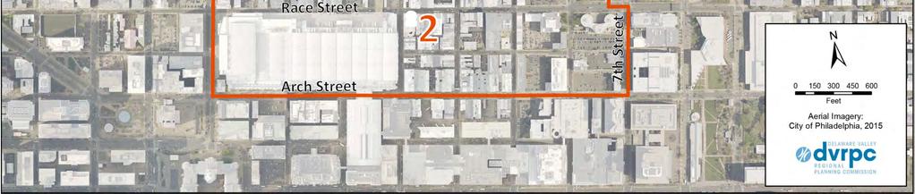
2 Scope of Work: Study Area
3 Project Goals Develop traffic calming alternatives to the Vine Street local right of way, to mitigate speeding. Develop concept plans and evaluate the feasibility of lane reconfiguration and other treatments. Develop recommendations to facilitate safe transportation for all modes and users while supporting a vibrant community.


4 USDOT Every Place Counts (2016)

5 Chinatown Neighborhood Plan (2017) CONNECTIVITY 2.1 Bridge the community across Vine Street and the expressway 2.2 Make it safer and easier to walk and bike 2.3 Improve connections to transit 2.4 Create an inviting and beautiful public realm

6 Chinatown Neighborhood Plan (2017) OPEN SPACE 3.1 Create more public space and programming for community use 3.2 Improve access to existing and new spaces

7 Chinatown Connections (2017) 1 Make crossing the street along Race and Vine Streets safer for the 1000 s of seniors and children who cross every single day. 2 Create two to three safe routes to parks and public spaces. 3 Provide support to local organizations to regularly activate public spaces in and around Chinatown. Mapping Activities
8 Vision Statement Reviving Vine will increase neighborhood connections by enhancing multimodal, inclusive mobility options in the Vine Street corridor. By improving safety and rebalancing roadway uses, the project will empower residents and visitors to reclaim Vine Street as public space for all users.

9 Scope of Work: Key Tasks 1 Collect and Analyze Data 2 Model Existing Conditions and No Build Scenario 3 Develop Improvement Alternatives 4 Analyze Improvement Alternatives 5 Public Engagement 6 Report
10 Task 1: Collect and Analyze Data
11 Study Area

12 Existing Land Use DVRPC 2015


13 New Developments in Study Area City Planning Commission 2017, City of Philadelphia 2016, DVRPC 2018

14 Census Tracts 2010 Census
15 Category Census Tract 2 (from Vine to Arch St) Census Tract 376 (from Vine to Spring Garden to Green St) Regional Threshold Population Estimate 2,304 2,736 N/A DVRPC Indicators of Potential Disadvantage (IPD) 5 5 N/A Non Hispanic Minority (%) 59.5% 48.9% 28.36% Hispanics 0.0%* 0.0%* 9.09% Carless Households ( Transit Dependent ) 45.6% 41.2% 14.25% Limited English Proficiency 22.5% 16.3% 3.44% Households in Poverty 22.4% 27% 12.78% Elderly (75 years and older) 8.0% 2.6% 6.55% Persons with Disabilities 6.3% 13% 12.14% Female Head of Household with Child 0.0%* 7.4% 8.69% Indicators of Potential Disadvantage ACS Year Estimates, DVRPC Indicators of Potential Disadvantage Webmap
16 59% 59% 42% 30% 26% 32% 19% 4% 2% 1% 8% 7% 5% 4% 1% Car, Truck, or Van Public Transportation Bicycle Walk Other Workers 16+ Living in Study Area Workers 16+ Living in Philadelphia Workers 16+ Employed in Study Area Commuting Patterns Census Transportation Planning Products (CTPP) Year Data

17 Sidewalk Infrastructure DVRPC December 2017


18 Weekday Pedestrian Volume by Intersection DVRPC Traffic Counts, February 2017

19 Weekday Pedestrian Volume by Crosswalk DVRPC Traffic Counts, February 2017


20 Bicycle Lanes Philadelphia Streets Department 2014, DVRPC 2018

21 Weekday Bicycle Volume by Crosswalk DVRPC Traffic Counts, February 2017


22 Average Weekday Transit Boardings and Alightings SEPTA 2016, NJ Transit 2018

23 Parking Capacity Philadelphia City Planning Commission 2015, DVRPC 2017

24 Parking Violations DVRPC 2017, weekday field observations


25 Weekday Vehicle Speed and Volume Counts DVRPC Traffic Counts, October 2017

26 Weekday Peak Vehicle Turning Movements DVRPC Traffic Counts, February AM Peak: 8:00-9:00AM. PM Peak: 4:45-5:45PM.
27 Task 1 Takeaways Safety, accessibility, walkability Traffic calming particularly on Vine West Pedestrian improvements on 8 th, 10 th, and 13 th Bike lane improvements and connections
28 Task 2: Model Existing Conditions and No Build Scenarios

29 Existing Conditions: Level of Service
30 Future No Build Scenario Applied background traffic growth factor Horizon year 2025
31 Background Traffic Growth Factors Federal Functional Class Study Area Street Segments Average Annual Traffic Growth (Forecasted) Total Traffic Growth (Forecasted) Minor Arterial Vine Street East and West 13th Street from Race to Vine 12th Street from Race to Callowhill 11th Street from Race to Callowhill 0.66% 5.28% Major Collector 13th Street from Vine to Callowhill 10th Street from Race to Callowhill 9th Street from Race to Callowhill 8th Street from Race to Callowhill 0.53% 4.24% Other Principal Arterial Broad Street from Race to Callowhill 0.41% 3.24%
32 Future No Build (2025): Level of Service
33 Future No Build with Developments Applied background traffic growth factor Horizon year 2025 Estimated trip generation from new developments Applied trips to model

34 Future No Build with Developments (2025): Developments Considered for Trip Generation
35 Estimated Trips Generated Location Residential Units Commercial SF Estimated Trips Generated: Weekday AM Peak Estimated Trips Generated: Weekday PM Peak 10th Street and Vine West , Ridge Avenue 48 2, Callowhill Street , North 13th Street North Broad Street (complete) 110 6, North Broad Street (complete) , Total ,
: Level")
36 Future No Build with Developments (2025): Level of Service
37 LOS Summary Table Intersection Existing AM No Build No Build with Developments Existing PM No Build No Build with Developments Vine EB & Broad C C C C C D Vine EB & 13th B B B B B B Vine EB & 12th B B B B B B Vine EB & 11th B B B B B B Vine EB & 10th A A A B B B Vine EB & 9th A A A A A B Vine EB & 8th D D D C D D Vine WB & Broad C D D C C C Vine WB & 13th B B C B B B Vine WB & 12th B B C B B B Vine WB & 11th A A B B B B Vine WB & 10th A B B B B B Vine WB & 9th A A A A A A Vine WB & 8th B B B B C C
38 Task 2 Takeaways LOS lowest at: Broad and Vine West Broad and Vine East 8 th and Vine East Capacity reduction may be feasible
39 Task 3: Develop Improvement Alternatives
40 Potential Improvements Lane reconfiguration East/west North/south Signal timing Street geometry Other? Key locations Constraints Plans
41 Public Meeting Purpose Invitees Potential Dates (April 9, 10, 11, 12, 13)
42 Next Steps Meeting notes Finalize/promote public meeting Tasks 3/4: Develop/analyze improvement alternatives
Town of Bethlehem. Planning Assessment. Bethlehem Town Board
 Town of Bethlehem US 9W Corridor Transportation Planning Assessment Presented e to: Bethlehem Town Board June 2009 Overview Study Background Route 9W Corridor Conditions and Improvements Selkirk Bypass
Dr. M.L. King, Jr. Street North Complete Streets Resurfacing Opportunities HOUSING, LAND USE, AND TRANSPORTATION COMMITTEE MARCH 22, 2018
 Dr. M.L. King, Jr. Street North Complete Streets Resurfacing Opportunities HOUSING, LAND USE, AND TRANSPORTATION COMMITTEE MARCH 22, 2018 What s Happening The City plans to mill and resurface Dr. M.L.
THE PHILADELPHIA COMPLETE. an overview
 THE PHILADELPHIA COMPLETE STREETS DESIGN HANDBOOK an overview WHAT ARE COMPLETE STREETS? Complete Streets are streets designed to accommodate all users, from pedestrians to drivers Complete Streets provide
TRANSPORTATION & MOBILITY
 TRANSPORTATION & MOBILITY ROADWAY SYSTEM There are approximately 40 miles of roadways in Manitou Springs. For planning purposes, roadways are typically assigned a functional classification which defines
A Matter of Fairness: ROCOG s Environmental Justice Protocol. What is Mobility Limitation?
 No Person Left Behind What is Mobility Limitation? What is the Access Limitation? Environmental Justice population should be provided adequate mobility & access to meet their needs; Identify acceptable
WALKNBIKE DRAFT PLAN NASHVILLE, TENNESSEE EXECUTIVE SUMMARY NASHVILLE, TENNESSEE
 NASHVILLE, TENNESSEE EXECUTIVE SUMMARY Executive Summary A world-class multi-modal transportation system is essential to a vibrant city and better quality of life. -Mayor Barry The WalknBike plan aims
MARKET/JFK VISION ZERO PILOT PROJECT FEBRUARY 2019 EVALUATION REPORT
 MARKET/JFK VISION ZERO PILOT PROJECT FEBRUARY 2019 EVALUATION REPORT WHY IS THIS PROJECT IMPORTANT? Market Street and JFK Boulevard in Center City are key east-west corridors in the core business district.
Memorandum. Purpose: To update the MPO CTAC on the status of the LRTP scenario evaluation process.
 Charlottesville-Albemarle Metropolitan Planning Organization POB 1505, 401 E. Water St, Charlottesville, VA 22902 www.tjpdc.org (434) 979-7310 phone info@tjpdc.org email Memorandum To: MPO CTAC From: Wood
ADOT Statewide Bicycle and Pedestrian Program Summary of Phase IV Activities APPENDIX B PEDESTRIAN DEMAND INDEX
 ADOT Statewide Bicycle and Pedestrian Program Summary of Activities APPENDIX B PEDESTRIAN DEMAND INDEX May 24, 2009 Pedestrian Demand Index for State Highway Facilities Revised: May 29, 2007 Introduction
Building Community Partnerships for Mobility:
 Building Community Partnerships for Mobility: San Francisco 2008 Presented by: Cynthia Hoyle, AICP Transportation Planning Consultant Champaign-Urbana Mass Transit District Background The Heartland Champaign-Urbana,
5858 N COLLEGE, LLC N College Avenue Traffic Impact Study
 5858 N COLLEGE, LLC nue Traffic Impact Study August 22, 2016 Contents Traffic Impact Study Page Preparer Qualifications... 1 Introduction... 2 Existing Roadway Conditions... 5 Existing Traffic Conditions...
I-105 Corridor Sustainability Study (CSS)
") I-105 Corridor Sustainability Study (CSS) Metro Streets and Freeways Subcommittee March 21, 2019 Gary Hamrick Cambridge Systematics, Inc. I-105 CSS Project History & Background Funded by Caltrans Sustainable
I-105 Corridor Sustainability Study (CSS) Metro Streets and Freeways Subcommittee March 21, 2019 Gary Hamrick Cambridge Systematics, Inc. I-105 CSS Project History & Background Funded by Caltrans Sustainable
4. ENVIRONMENTAL IMPACT ANALYSIS 9. TRANSPORTATION AND TRAFFIC
 4. ENVIRONMENTAL IMPACT ANALYSIS 9. TRANSPORTATION AND TRAFFIC 4.9.1 INTRODUCTION The following section addresses the Proposed Project s impact on transportation and traffic based on the Traffic Study
10TH & 13TH STREET ROADWAY RECONFIGURATION & PROTECTED BICYCLE LANE PROJECTS
 10TH & 13TH STREET ROADWAY RECONFIGURATION & PROTECTED BICYCLE LANE PROJECTS GOALS & OBJECTIVES Create high quality bicycle network in Center City Reconfi gure the parking and loading layout to meet the
CITY OF COCOA BEACH 2025 COMPREHENSIVE PLAN. Section VIII Mobility Element Goals, Objectives, and Policies
 CITY OF COCOA BEACH 2025 COMPREHENSIVE PLAN Section VIII Mobility Element Goals, Objectives, and Policies Adopted August 6, 2015 by Ordinance No. 1591 VIII MOBILITY ELEMENT Table of Contents Page Number
Draft MOBILITY ELEMENET. Community Meeting May 22, 2013
 Draft MOBILITY ELEMENET Community Meeting May 22, 2013 Agenda Presentation Ira Brown New Mobility Paradigm Movement of People Implementation Q&A Ira Brown and Dave Roseman Small Group Discussion at Each
Vision Zero Task Force February 28, Collision Landscape Analysis
 Vision Zero Task Force February 28, 2017 Collision Landscape Analysis Welcome! What happened since our last Task Force meeting: City Council adopted the Vision Zero Resolution Applied for an OTS grant
Community Task Force July 25, 2017
 Community Task Force July 25, 2017 Welcome and Introductions Project Partners Regional Transportation District (RTD) Colorado Department of Transportation (CDOT) Denver Regional Council of Governments
Route 7 Corridor Study
 Route 7 Corridor Study Executive Summary Study Area The following report analyzes a segment of the Virginia State Route 7 corridor. The corridor study area, spanning over 5 miles in length, is a multi
Henderson Avenue Mixed-Use Development
 Zoning Case: Z145-3 Traffic Impact Analysis Henderson Avenue Mixed-Use Development Dallas, TX October 26 th, 216 Kimley-Horn and Associates, Inc. Dallas, Texas Project #644827 Registered Firm F-928 Traffic
Paoli Road Improvement Feasibility Study
 Paoli Road Improvement Feasibility Study & Public Participation Project March 24, 2015 Prepared for: Tredyffrin Township Prepared by: McMahon Associates, Inc. with Town Planning Partnership, LLC Glackin
INNER LOOP EAST. AIA Rochester Annual Meeting November 13, 2013 TRANSFORMATION PROJECT. Bret Garwood, NBD Erik Frisch, DES
 INNER LOOP EAST TRANSFORMATION PROJECT AIA Rochester Annual Meeting November 13, 2013 Bret Garwood, NBD Erik Frisch, DES Why? We are building a city that encourages walking, biking and enjoying the outdoor
Clackamas County Comprehensive Plan
 ROADWAYS The County s road system permits the movement of goods and people between communities and regions, using any of a variety of modes of travel. Roads provide access to virtually all property. They
AMENDING MOTION: Mobility Plan - Pedestrians and Disadvantaged Communities
 I MOVE that the Council: AMENDING MOTION: Mobility Plan - Pedestrians and Disadvantaged Communities 1. INSTRUCT the Department of City Planning to amend the proposed Mobility Plan to include the following;
CLOSED. The draft concept design has been broken down into 5 categories for the purpose of this survey:
 Old Strathcona s neighbourhood renewal process is now at the draft concept design phase. Over the last several months, the city has been gathering local knowledge and resident input that has been used
City of Homewood Transportation Plan
 City of Homewood Transportation Plan Prepared for: City of Homewood, Alabama Prepared by: Skipper Consulting, Inc. May 2007 TABLE OF CONTENTS INTRODUCTION... 1 BACKGROUND INFORMATION... 1 EXISTING TRANSPORTATION
WELCOME. Traffic & Parking Commission Special Meeting May 30, Iteris, Inc. All rights reserved.
 WELCOME Traffic & Parking Commission Special Meeting May 30, 2018 WORKSHOP #2 CONCEPTS FOR IMPROVEMENT MAY 30, 2018 Agenda 1. Welcome 10 min 2. Project Presentation 25 min 3. Roundtable Dialogue 50 min
Chapter 14 PARLIER RELATIONSHIP TO CITY PLANS AND POLICIES. Recommendations to Improve Pedestrian Safety in the City of Parlier (2014)
") Chapter 14 PARLIER This chapter describes the current status and future plans for biking and walking in the City of Parlier. RELATIONSHIP TO CITY PLANS AND POLICIES The Parlier General Plan is the primary
Chapter 14 PARLIER This chapter describes the current status and future plans for biking and walking in the City of Parlier. RELATIONSHIP TO CITY PLANS AND POLICIES The Parlier General Plan is the primary
Community Task Force March 14, 2018
 Community Task Force March 14, 2018 Welcome and Introductions Project Partners Regional Transportation District (RTD) City of Aurora Colorado Department of Transportation (CDOT) Denver Regional Council
Magnolia Place. Traffic Impact Analysis. Prepared for: City of San Mateo. Prepared by: Hexagon Transportation Consultants, Inc.
 Magnolia Place Traffic Impact Analysis Prepared for: City of San Mateo Prepared by: Hexagon Transportation Consultants, Inc. Updated January 4, 2010 Table of Contents 1. Introduction...1 2. Existing Conditions...6
Complete Street Analysis of a Road Diet: Orange Grove Boulevard, Pasadena, CA
 Complete Street Analysis of a Road Diet: Orange Grove Boulevard, Pasadena, CA Aaron Elias, Bill Cisco Abstract As part of evaluating the feasibility of a road diet on Orange Grove Boulevard in Pasadena,
TRAFFIC IMPACT ANALYSIS
 TRAFFIC IMPACT ANALYSIS FOR THE CHAMPAIGN UNIT#4 SCHOOL DISTRICT PROPOSED HIGH SCHOOL (SPALDING PARK SITE) IN THE CITY OF CHAMPAIGN Final Report Champaign Urbana Urbanized Area Transportation Study 6/24/2014
5.0 Roadway System Plan
 Southwest Boise Transportation Study Page 16 5.0 Roadway System Plan The Roadway System Plan outlines roadway improvements in the Initial Study Area. It forecasts future deficiencies on the arterial system,
SECTION 1 - TRAFFIC PLANNING
 SECTION 1 - TRAFFIC PLANNING 1.1 TRAFFIC OPERATIONS 1.1.1 Roadway Functional Classification The Multnomah County Comprehensive Framework Plan s Policy 34: Trafficways and the Functional Classification
A CHANGING CITY. of Edmonton, it is essential that it reflects the long-term vision of the City.
 A CHANGING CITY By the year 2040, Edmonton will be home to more than 1 million people. To accommodate growth and support a healthy and compact city, we need a new approach to development/redevelopment
General Plan Circulation Element Update Scoping Meeting April 16, 2014 Santa Ana Senior Center, 424 W. 3rd Street, Santa Ana, CA 92701
 General Plan Circulation Element Update Scoping Meeting April 16, 2014 Santa Ana Senior Center, 424 W. 3rd Street, Santa Ana, CA 92701 Meeting Agenda 1. Purpose of Scoping Meeting 2. Project Overview 3.
122 Avenue: 107 Street to Fort Road
 : 107 Street to Fort Road November 24, 2015 4:30 8:00 p.m. Meeting Purpose Summarize project work completed to date Share results of public input from Phase 1 Share the draft concept plan and proposed
About the study. North Milwaukee Ave. Key goals of this study are to: Achieve Vision Zero* by. Harmonize the space and improve walkability
 About the study Key goals of this study are to: North Milwaukee Avenue is a local and regional street for multiple modes of transportation. It is officially zoned and functions as a pedestrian street southeast
AGENDA ITEM NO. 5b HCAOG TAC meeting of May 8, 2014
 Humboldt County Association of Governments Eureka, CA, 95501 AGENDA ITEM NO. 5b HCAOG TAC meeting of May 8, 2014 DATE: May 1, 2014 TO: HCAOG Technical Advisory Committee (TAC) FROM:, SUBJECT: Letters of
Chapter 5. Complete Streets and Walkable Communities.
 Chapter 5. Complete Streets and Walkable Communities. 5.1 Description of Complete Streets. Cities throughout the world, and specifically the United States, are coming to embrace a new transportation and
CLOSED. Highlights of the Final Concept Design:
 The final Concept Design is the result of many months of listening, learning, creating, balancing, and understanding different needs and viewpoints, as well as incorporating technical requirements and
Complete Streets Successes, Opportunities, and Challenges
 Complete Streets Successes, Opportunities, and Challenges Juliet Walker, Transportation Planner, City of Portsmouth Rob Houseman, Director of Planning and Development, Town of Wolfeboro Chris Parker, Director
Goodlettsville Bicycle and Pedestrian Plan Executive Summary
 Goodlettsville Bicycle and Pedestrian Plan July 2010 In Cooperation with the Nashville Area Metropolitan Planning Executive Organization Summary Introduction Progressive and forward thinking communities
North Coast Corridor:
 North Coast Corridor: Connecting People, Transportation & Environment Legislative Hearing: 11.8.10 1 North Coast Corridor Region s Lifeline A Regional Strategy Mobility, Economy & Environment North Coast
Highway 111 Corridor Study
 Highway 111 Corridor Study June, 2009 LINCOLN CO. HWY 111 CORRIDOR STUDY Draft Study Tea, South Dakota Prepared for City of Tea Sioux Falls Metropolitan Planning Organization Prepared by HDR Engineering,
CITY OF SPOKANE VALLEY Request for Council Action
 CITY OF SPOKANE VALLEY Request for Council Action Meeting Date: December 16, 2014 Department Director Approval: Check all that apply: consent old business new business public hearing information admin.
SR 693 (Pasadena Avenue) Corridor Study from Shore Drive South to 66 th Street
 Corridor Study from Shore Drive South to 66 th Street") Welcome and Introduction Sign-in and comment sheets Restrooms and exits Meeting agenda and timeline Meeting goals / expectations Provide input to guide study recommendations Actively participate throughout
Welcome and Introduction Sign-in and comment sheets Restrooms and exits Meeting agenda and timeline Meeting goals / expectations Provide input to guide study recommendations Actively participate throughout
Gateway Transportation Study
 Gateway Transportation Study Amherst, Massachusetts SUBMITTED TO University of Massachusetts Amherst Town of Amherst SUBMITTED BY Vanasse Hangen Brustlin, Inc. Watertown, Massachusetts March 213 Back of
Double Dutch: Bicycling Jumps in Philadelphia
 Double Dutch: Bicycling Jumps in Philadelphia Introduction The path to urban sustainability is paved by streets that accommodate all users, not just cars and trucks. 20 th Century transportation policy
Community Transportation Plan Acknowledgements
 Community Transportation Plan Acknowledgements The Decatur CTP was developed with participation and guidance from City of Decatur staff, its Resident Boards and Commissions, and numerous residents, business
Downtown Naples Mobility and Connectivity Study. Naples City Council Presentation January 2017
 Downtown Naples Mobility and Connectivity Study Naples City Council Presentation January 2017 Agenda 1. Introduction 2. Scope Review 3. Project Schedule 4. Existing Conditions 5. Public Charrette 6. Mobility
Lynn Valley Town Centre Transportation Study 2013
 Lynn Valley Town Centre Transportation Study 2013 In 2013, Urban Systems consultants completed a comprehensive Transportation Study for Lynn Valley Town Centre. The study assessed worst case scenario of
Lord Overpass Multi-Modal Boulevard. Nicolas Bosonetto, P.E.
 Lord Overpass Multi-Modal Boulevard Nicolas Bosonetto, P.E. City of Lowell Fourth Largest City in Commonwealth Population of 109,945 Gateway City Diverse 20% Southeast Asian 17% Hispanic 25% Foreign Born
43 rd Avenue, Skillman Avenue Protected Bike Lanes
 43 rd Avenue, Skillman Avenue Protected Bike Lanes Presented to Queens Community Board 2 Transportation Committee - November 6, 2017 43 rd Avenue, Skillman Avenue: Presentation Overview Background Project
JULY Ridge Pike. Lower Providence Township MONTGOMERY COUNTY
 JULY 2013 Ridge Pike Lower Providence Township MONTGOMERY COUNTY JULY 2013 Ridge Pike Lower Providence Township MONTGOMERY COUNTY PA BUCKS MERCER MONTGOMERY CHESTER PHILADELPHIA DELAWARE BURLINGTON New
4.0 TRAFFIC IMPACT STUDIES
 SECTION 4 4.0 TRAFFIC IMPACT STUDIES 4.1 TRAFFIC IMPACT STUDY REQUIREMENTS The City has established Traffic Impact Study (TIS) requirements for the purpose of ensuring that both the quantitative and qualitative
Albany Shaker Road Corridor Study Public Meeting # 2
 Albany Shaker Road Corridor Study Public Meeting # 2 Scope / Meeting Purpose This project is a CDTC Linkage Study. The Linkage Program is designed to implement the adopted planning and investment principles
Colchester/Riverside/Barrett/ Mill Intersection Study. PAC Meeting #3 September 22, 2016
 Colchester/Riverside/Barrett/ Mill Intersection Study PAC Meeting #3 September 22, 2016 Tonight s Agenda Review Project Purpose and Need Describe short term and long improvements and changes since public
Central Freeway and Octavia Circulation Study
 Central Freeway and Octavia Circulation Study Final Report Plans and Programs Committee San Francisco County Transportation Authority September 18, 2012 Presentation Outline Background and Study Purpose
Walmart (Store # ) 60 th Street North and Marion Road Sioux Falls, South Dakota
 60 th Street North and Marion Road Sioux Falls, South Dakota") Walmart (Store #4865-00) 60 th Street North and Marion Road Sioux Falls, South Dakota Prepared for: Wal-Mart Stores, Inc. Bentonville, Arkansas Prepared by: Kimley-Horn and Associates, Inc. ã2013 Kimley-Horn
Walmart (Store #4865-00) 60 th Street North and Marion Road Sioux Falls, South Dakota Prepared for: Wal-Mart Stores, Inc. Bentonville, Arkansas Prepared by: Kimley-Horn and Associates, Inc. ã2013 Kimley-Horn
Welcome. If you have any questions or comments on the project, please contact:
 Welcome This drop-in public open house is intended to provide information about the Bay Street bike lanes project. This project proposes a dedicated cycling facility along Bay Street between Aberdeen Avenue
Chapter 5 Future Transportation
 Chapter 5 Future Transportation The Future Land Use Plan identifies the desired land use designations. The land uses desired for Crozet depend, in large part, on the success of the transportation system,
BETHEL ROAD AND SEDGWICK ROAD CORRIDOR STUDY
 DRAFT PLAN City Council Meeting August 14, 2017 STUDY AREA Sedgwick Corridor State Route 160, principal arterial with Class 3 access management designation, commuter and freight route, connection to SR
BID Strategy Group and Stakeholders Meeting. April 17, 2018
 BID Strategy Group and Stakeholders Meeting April 17, 2018 Agenda Meeting Objectives Background Short-Term Improvements Long-Term Study Goals Data Review Schedule & Next Steps Open House April 17, 2018
Typical Rush Hour Commute. PennyforTransportation.com
 Typical Rush Hour Commute In the News Overview of the Plan Collaborative plan with projects in every community Prioritizing connectivity and congestion relief Dedicated transportation-specific funding;
DRAFT BUENA VISTA 2020 TRANSPORTATION PLAN
 DRAFT BUENA VISTA 2020 TRANSPORTATION PLAN DEVELOPED BY THE TRANSPORTATION PLANNING DIVISION OF THE VIRGINIA DEPARTMENT OF TRANSPORTATION IN COOPERATION WITH THE U.S. DEPARTMENT OF TRANSPORTATION, FEDERAL
Bluffdale/ UDOT South High-T Intersection Project Type Operations
 Bluffdale/ UDOT 14600 South High-T Intersection Project Type Operations 14600 South and Redwood Road $ 600,000 $ 550,000 This project is to install a new High-T intersection at Redwood Road and 14600 South
THIS PAGE LEFT BLANK INTENTIONALLY
 GA SR 25 Spur at Canal Road Transportation Impact Analysis PREPARED FOR GLYNN COUNTY, GEORGIA 1725 Reynolds Street, Suite 300 Brunswick, Georgia 31520 PREPARED BY 217 Arrowhead Boulevard Suite 26 Jonesboro,
Glenn Avenue Corridor Traffic Operational Evaluation
 Glenn Avenue Corridor Traffic Operational Evaluation PREPARED FOR: THE CITY OF AUBURN PREPARED BY: DECEMBER 2007 Glenn Avenue Corridor Study--Auburn, Alabama TABLE OF CONTENTS Introduction... 1 Background
Transportation Planning in Western SoMa
 Transportation Planning in Western SoMa Michelle Reyes Natasha Casanares Ryan Dodge Matthew West San Francisco State University Urban Studies Program Senior Seminar Spring 2007 Outline Background Deliverables
City of Novi Non-Motorized Master Plan 2011 Executive Summary
 City of Novi Non-Motorized Master Plan 2011 Executive Summary Prepared by: February 28, 2011 Why Plan? Encouraging healthy, active lifestyles through pathway and sidewalk connectivity has been a focus
South King County High-Capacity Transit Corridor Study
 HIGH-CAPACITY TRANSIT CORRIDOR STUDY South King County Corridor South King County High-Capacity Transit Corridor Study Corridor Report August 2014 South King County High Capacity Transit Corridor Report
Bridge Street Corridor Study Report
 Bridge Street Corridor Study Report Prepared for: Prepared by: BRIDGE STREET CORRIDOR STUDY REPORT PREPARED FOR: CITY OF ARROYO GRANDE COMMUNITY DEVELOPMENT DEPARTMENT 300 EAST BRANCH STREET ARROYO GRANDE,
Land Use and Transportation Town Hall September 17, 2018
 Land Use and Transportation Town Hall September 17, 2018 Welcome! Tonight s Agenda: 7:00-7:30 OVERVIEW PRESENTATIONS 7:30-8:15 BREAKOUT SESSIONS 8:15 - End TOWN HALL CITIZEN S TIME Purpose of Tonight s
TRANSPORTATION TRAINING TOPICS. April 6, 2010
 TRANSPORTATION TRAINING TOPICS April 6, 2010 Roles of Transportation Providers Context and Policy Makers Division of Transportation and Traffic Other City Operations Other Transportation Operators CMA
Solana Beach Comprehensive Active Transportation Strategy (CATS)
") Solana Beach Comprehensive Active Transportation Strategy (CATS) 3.0 Goals & Policies The Solana Beach CATS goals and objectives outlined below were largely drawn from the Solana Beach Circulation Element
Solana Beach Comprehensive Active Transportation Strategy (CATS) 3.0 Goals & Policies The Solana Beach CATS goals and objectives outlined below were largely drawn from the Solana Beach Circulation Element
Bellevue Transportation: Challenges, Opportunities and Priorities Bellevue Downtown Association September 20, 2018
 Bellevue Transportation: Challenges, Opportunities and Priorities Bellevue Downtown Association September 20, 2018 Dave Berg Transportation Director City of Bellevue Traffic, traffic and more traffic!
Exhibit 1 PLANNING COMMISSION AGENDA ITEM
 Exhibit 1 PLANNING COMMISSION AGENDA ITEM Project Name: Grand Junction Circulation Plan Grand Junction Complete Streets Policy Applicant: City of Grand Junction Representative: David Thornton Address:
Bicycle Master Plan Goals, Strategies, and Policies
 Bicycle Master Plan Goals, Strategies, and Policies Mobilizing 5 This chapter outlines the overarching goals, action statements, and action items Long Beach will take in order to achieve its vision of
Bay to Bay Boulevard Complete Streets Project
 Bay to Bay Boulevard Complete Streets Project Dale Mabry Highway to Bayshore Boulevard February 08, 2018 Photo Source: Tampa Bay Times Alessandra Da Pra Meeting Format Introduction Resurfacing Information
 Community and Business Outreach November 2015 Goal #1: Improve safety in the corridor Goal #2: Make a more livable corridor Goal #3: Improve mobility for all Data Collection Alternatives Recommendations
CITY OF BLOOMINGTON COMPLETE STREETS POLICY
 CITY OF BLOOMINGTON COMPLETE STREETS POLICY POLICY OBJECTIVE: The City of Bloomington will enhance safety, mobility, accessibility and convenience for transportation network users of all ages and abilities,
LSC TRANSPORTATION CONSULTANTS, INC. 516 North Tejon Street Colorado Springs, CO (719) FAX (719)
 FAX (719)") LSC TRANSPORTATION CONSULTANTS, INC. 516 North Tejon Street Colorado Springs, CO 80903 (719) 633-2868 FAX (719) 633-5430 E-mail: lsc@lsccs.com May 15, 2009 Mr. Davis Farrar Western Slope Consulting, LLC
LSC TRANSPORTATION CONSULTANTS, INC. 516 North Tejon Street Colorado Springs, CO 80903 (719) 633-2868 FAX (719) 633-5430 E-mail: lsc@lsccs.com May 15, 2009 Mr. Davis Farrar Western Slope Consulting, LLC
CITY OF LOMITA CITY COUNCIL REPORT
 CITY OF LOMITA CITY COUNCIL REPORT TO: FROM: City Council Ryan Smoot, City Manager Item No. SCH 12 PREPARED BY: Mark A. McAvoy, P.E., Public Works Director/City Engineer MEETING DATE: August 1, 2017 SUBJECT:
San Jose Transportation Policy
 San Jose Transportation Policy Protected Intersections in LOS Policies to Support Smart Growth Presented by: Manuel Pineda City of San Jose Department of Transportation Bay Area Map San Francisco Oakland
WELCOME Public Information Centre
 WELCOME Public Information Centre Fernforest Drive Brampton Soccer Centre Community Room #2 Tuesday January 19, 2016 6:30 p.m.to 9:00 p.m. Please sign in Neighbourhood Traffic Calming Guide Background
Public Information Centre
 WELCOME Public Information Centre Father Tobin Road Lougheed Middle School - Library Wednesday November 7, 2012 7:00 p.m.to 9:00 p.m. Please sign in Neighbourhood Traffic Calming Guide Background The City
CORAL RIDGE COUNTRY CLUB ESTATES NEIGHBORHOOD MOBILITY MASTERPLAN
 CORAL RIDGE COUNTRY CLUB ESTATES NEIGHBORHOOD MOBILITY MASTERPLAN Coral Ridge Country Club Estates Neighborhood Mobility Masterplan August 2015 Coral Ridge Country Club Neighborhood Mobility Masterplan
1609 E. FRANKLIN STREET HOTEL TRAFFIC IMPACT STUDY EXECUTIVE SUMMARY
 1609 E. FRANKLIN STREET HOTEL TRAFFIC IMPACT STUDY EXECUTIVE SUMMARY Prepared for: The Town of Chapel Hill Public Works Department Traffic Engineering Division Prepared by: HNTB North Carolina, PC 343
Final Sidewalk Feasibility Study
 Garfield Drive From Anastasia Drive to Elizabeth Place City of South Daytona July 23, 2009 Final Sidewalk Feasibility Study Prepared for: Prepared by: Final Sidewalk Feasibility Study Garfield Drive 2
ROADSOADS CONGESTION HAMPTON SYSTEMYSTEM MANAGEMENT. Part II Roadway Congestion Analysis Mitigation Strategies and Evaluation
 HAMPTON ROADSOADS CONGESTION MANAGEMENT SYSTEMYSTEM Part II Roadway Congestion Analysis Mitigation Strategies and Evaluation Presented by: Dwight Farmer, PE Deputy Executive Director, Transportation April
Brian D. Hare, P.E. Bureau of Design PennDOT PA APA Annual Conference Investing in a Sustainable Future October 5, 2009
 Brian D. Hare, P.E. Bureau of Design PennDOT 2009 PA APA Annual Conference Investing in a Sustainable Future October 5, 2009 1 What is Smart Transportation? Photographer: heyjude. Used through license
CONNECTIVITY PLAN. Adopted December 5, 2017 City of Virginia Beach
 CONNECTIVITY PLAN Adopted December 5, 2017 City of Virginia Beach CONTENTS 1.0 Background & Purpose... 2 2.0 Existing Inventory & Analysis... 3 ViBe District Existing Walking Conditions... 4 3.0 ViBe District
2016 Planning Conference July 26, CONNECT COLUMBUS Building Columbus Transportation Future
 2016 Planning Conference July 26, 2016 CONNECT COLUMBUS Building Columbus Transportation Future What Is Connect Columbus? Project Process OUR PROCESS COMPLETE ONGOING Discovery + Desire Project Goals Columbus
1 st and 2 nd Street Couplet FAQ s
 1 st and 2 nd Street Couplet FAQ s Q. Will the proposed roundabout at Flume/2nd/1 st Streets affect access to businesses nearby?... 2 Q. What if the project isn t received well by the community after construction?...
CITY OF LOS ANGELES INTER-DEPARTMENTAL MEMORANDUM
 CITY OF LOS ANGELES INTER-DEPARTMENTAL MEMORANDUM Date: April 1, 219 To: Honorable City Council c/o City Clerk, Room 395, City Hall Attention: Honorable Mike Bonin, Chair, Transportation Committee From:
o n - m o t o r i z e d transportation is an overlooked element that can greatly enhance the overall quality of life for the community s residents.
 N o n - m o t o r i z e d transportation is an overlooked element that can greatly enhance the overall quality of life for the community s residents. 84 Transportation CHAPTER 11 INTRODUCTION Transportation
Advancing Transportation Choices in Des Moines. MPO Environmental Roundtable January 9, 2018
 Advancing Transportation Choices in Des Moines MPO Environmental Roundtable January 9, 2018 Presented by Jennifer McCoy, PE, PTOE City Traffic Engineer Agenda Des Moines Area Transportation Planning Connect
Third Street Bridge & Corridor Project
 Third Street Bridge & Corridor Project Preparation for the FY2018 budget to commence October 1, 2017, includes funding to address a project that has been considered since 1994. The Third Street bridge
TRANSPORTATION IMPACT ANALYSIS
 TRANSPORTATION IMPACT ANALYSIS CAROLINA NORTH DEVELOPMENT May 7, 2009 Kumar Neppalli Engineering Services Manager Town of Chapel Hill Christopher Conklin, PE Principal VHB/Vanasse Hangen Brustlin, Inc.