Iowa Corridor Management Pilot Project Overview. Recommendations For A Corridor Management Program August 2004
|
|
|
- Theodora Fletcher
- 5 years ago
- Views:
Transcription
1 Iowa Corridor Management Pilot Project Overview Recommendations For A Corridor Management Program August 2004
2 Presentation Overview Project goals Pilot project selection process Analysis results Segment types 1, 2, and 3 Driveway and traffic signal inventory/density analysis Safety Land use Key findings Segment types and their typical issues Recommended program (summary) Retrofit studies on existing corridors with issues (mainly Segment 1 situations) Corridor management agreements on corridors where future corridor management issues are likely to arise (Segment 2 situations) Cooperative planning with local jurisdictions (Segment 3 situations)
3 Project Goals Identify typical Iowa corridor management issues and problems Develop safety and land use analysis techniques to be used on other corridors Develop a framework for corridor management in Iowa Involve several Iowa DOT offices plus Districts and metropolitan/regional planning organizations
4 Corridor Planning Pilot Project Selection Process Two pilot projects were selected by Iowa DOT management Both of the pilot corridors selected for detailed analysis ranked in the top ten in a previous study that identified the top priority candidates for corridor management in Iowa based on: Crash statistics Importance for commuting Likelihood of future access management issues

5 Key Commuting Routes In Iowa: 2004 Estimated Work Trips
6 Three Corridor Segment Types 1 1 Urban 2 Fringe 3 Rural 2 3
7 Segment 1 1 Urban Segments Urbanized Largely built out Predominately commercial land use Relatively well-managed in terms of commercial driveway density and medians Relatively high traffic signal density Low incidence of left-turning turning crashes; higher rates of right turn and (especially) rear-end end collisions at traffic signals Some opportunity for retrofit access management improvements

")
8 US 20 Urban Segment (1)
9 Segment 2 2 Fringe Segments Urbanizing (suburban and urban fringe) Largely undeveloped Considerable land development potential Likely use: mixture of commercial, industrial, and large lot residential Relatively well-managed in terms of commercial driveway density and medians at present A few traffic signals at major intersections or ramps Low incidence of left-turning turning crashes; higher rates of right turn and rear-end end collisions Considerable potential for future access management problems

")
10 US 20 Fringe Segment (2)
11 Rural Commuter Route Segments Segment 3 3 Rural, but within 30 minute commuter range Largely undeveloped Predominately agricultural land use Relatively well-managed in terms of commercial driveway density and medians No traffic signals Low incidence of left-turning turning crashes; low rates of right turn and rear-end end collisions Opportunities for spot access management problems at a few locations
")
12 US 20 Rural Segment (3)
13 Example Analysis Results: US 20 Corridor Near Dubuque Driveway locations and density Traffic signal location and density Safety: crashes frequency, type, and rate Land use: present and planned future
14 Driveway Density Analysis: US 20 Segment 1 Segment Length Driveway Count Driveways/ Mile 2.0 miles (low) Segment (low) Segment (very low) Segment 2 has several instances of moderate density.
15 Traffic Signals And Driveways: Segment 1 And Portion Of Segment 2 US 20 In Dubuque High driveway density Signals <0.5 mile spacing

16 Segment 2 Driveways Areas of concern

17 Segment 3 Driveways Very well managed segment
18 Safety Analysis Crash frequency Focus on access-related crashes Left-turn, turn, right-turn, turn, and rear-end end collisions Access-related crash rates Access-related crash severity
19 Current Safety Analysis US 20: Access-Related Crashes Segment 1 Segment 2 Segment 3 Corridor Rear End 67 (35%) 27 (25%) 0 (0%) 94 (26%) Right Turn 18 (9%) 8 (7%) 1 (2%) 27 (7%) Left Turn 1 (1%) 3 (3%) 3 (5%) 7 (2%) All Access- Related Total Crashes 86 (44%) 38 (35%) 4 (6%) 128 (35%) 194 (100%) 108 (100%) 64 (100%) 366 (100%) Note: Columns do not total to bottom number. Difference is non-access crashes.
20 Access-Related Crash Rates US 20 Segment 1 Segment 2 Segment 3 Access- Related 4.2 (Moderate) 1.5 (Low) Near Zero Probable access-related crash rates per million vehicle-miles traveled. Includes right-turn, left-turn, and rear-end collisions.

21 Crash Hot Spots: Segment 1 Rear-End Collisions Predominate
22 Safety Analysis For US 20: Conclusions Overall Roughly 35% of all crashes in the corridor are access- related, but these are concentrated in the urban and suburban portions (Segments 1 and 2) Access-related crashes tend to be severe Driveway densities are generally not high on the route, but there are several concentrations of commercial driveways that could be consolidated Segment 1 Has significant numbers of rear- end collisions and right turn crashes This is consistent with a multilane divided corridor with a high public road intersection density and high traffic signal density Segment 2 Has a less significant access- related safety problem than Segment 1 There are three problem sub- segments Some safety problems are associated with public road intersections rather than with driveways Segment 3 Safety problems are generally not access-related (crashes are run off the road, weather-related, related, animal crashes, etc.)
23 Land Use Analysis Analysis process employed current and projected future land development in GIS format Segment 1 Largely commercial Essentially built-out; little potential for further development except if re-developed Segment 2 Mixture of commercial, industrial, and agriculture Considerable potential for new commercial and industrial development with associated demand for driveways Segment 3 Largely agricultural except in and around cities Limited development at the edges of small cities
24 Segment 1: Largely Commercial And Mainly Built-Out
25 Segment 2: Mixed Land Use With Much Room For More Development Classic strip development
26 Segment 3: Mainly Agricultural With Mixed Use Near Cities
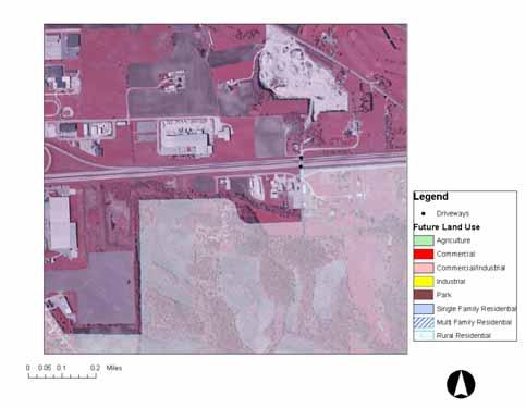
27 Future Land Use Analysis: US 20 Segment 1 will continue to exist as a commercial strip with some changes in individual parcels and businesses Segment 2 will likely continue to develop as a commercial/industrial strip (eastern half) and large lot residential (western half) This segment has (by far) the most potential for future land development Segment 3 will likely remain largely agricultural except in and near Peosta, Epworth, Farley, and Dyersville (small cities along the corridor)

28 Segment 2: Planned Industrial Development (Yellow)
29 Segment 2: Planned Development At The Dubuque Fringe (Yellow and Red)
30 Large Portions Of Segment 2 Are Planned As Low Density Residential Commercial uses (red) are clustered positive feature

31 Segment 3: Limited New Development Planned
32 Corridor Management Issues By Segment 1 Segment Type High density of public road intersections and median breaks High density of traffic signals Close spacing leads to a decline in mean travel speed, reduction in LOS, and an increase in rear end collision rates Lack of dedicated turning lanes at major intersections Discontinuous frontage road system Frontage road system too close to the mainline A handful of direct driveway accesses could be closed or consolidated
33 Corridor Management Issues By Segment 2 Segment Type Several areas with direct driveway accesses that could be closed or consolidated Areas of high crash rates that are usually related to land development and access decisions Discontinuous frontage road system Large potential for future access management issues as land develops Especially important in areas slated for commercial and industrial development
34 Corridor Management Issues By Segment 3 Segment Type Spot safety issues associated with individual developments Examples: Existing and potential commercial development near Farley and Epworth located around at-grade intersections Large, new BMX (cycling) facility located in a rural area
35 Overall Corridor Management Goals Reduce at-grade public road intersection density (full intersections), full median break density, and traffic signal density along Segment 1 Reduce direct driveway accesses where possible through driveway sharing and alternative access way development along Segment 2 Develop a complete frontage and backage road system where appropriate with a substantial separation from the mainline Improve land use planning along Segments 2 and 3 so that new commercial developments are clustered around existing and planned interchanges Clear commercial driveways a reasonable distance away from interchanges and major intersections
36 Ideal Corridor Configuration Segment 1 Urban expressway with high level of access control (or a freeway) mph mean travel speed Traffic signals spaced at least ½ mile apart No direct driveway accesses Full frontage road system with accesses to mainline at interchanges at least ½ miles apart (ideally 1 mile apart) Segments 2 and 3 Suburban/rural expressway with high level of access control mph mean travel speed Full median break spacing >1 mile (no traffic signals) Driveway spacing >0.25 miles (right-in in right out only, where possible ) Backage road system with accesses to mainline separated at least 1 mile
37 Suggested Iowa Corridor Management Program Framework Segment 1 Develop retrofit access management plans Segment 2 Develop corridor management 28E agreements New Iowa US 6 agreement as a model (District 4, Iowa DOT) NCHRP Synthesis as a tool Segment 3 Cooperative planning with local land use planning jurisdictions Spot corridor safety improvements Overall Improved inventories of driveway permit locations, access priority classification levels, and access rights obtained Automated access permitting system?
38 Suggested Items To Be Addressed In A Retrofit Access Management Study Segment 1 Situations Inventory: driveways, medians, Safety analysis: crash rates, locations, and types Present and future land use Traffic signal location and spacing Improved traffic control systems Dedicated turning lanes Frontage or backage road system and internal circulation in adjacent developments Consolidation and clearance of commercial driveways
39 Suggested Items Recommended To Be Included In A Corridor Management Intergovernmental Agreement Segment 2 Situations Public road interchanges and intersections Traffic signal locations Medians and median break locations Driveway locations and directions (e.g. right-in, in, right-out) Dedicated turning lane locations Alternative access ways (e.g. development of frontage and backage road systems) Generalized land use planning
40 Items That Could Be Pursued In Rural Parts Of Corridors Segment 3 Situations Some communities along key commuting corridors have no comprehensive land use plans or badly outdated plans Encourage them to develop and update plans Cooperatively review new development proposals for potential access and safety issues, especially those that involve commercial and industrial development Conduct spot safety and access analyses at current and potential problem locations
41 Expected Benefits Of A Corridor Management Program Preservation of the Iowa DOT s s multi-million million dollar investments in major corridors Maintain mean travel speed and LOS, especially on Segment 1s Lower rear-end end collision rates (mainly on Segment 1s) Lower right and left turning crash rates (mainly on Segment 2s) Preservation of Segment 3s, which are generally well- managed and safe now Maintenance of business environment on Segment 1s, which might otherwise begin to suffer due to higher travel times and greater congestion
42 Current Program Status Several Iowa DOT offices (Development, Location, Safety, Planning) are involved Each Iowa DOT District (1 through 6) is identifying a corridor for which an Intergovernmental Corridor Management Agreement will be developed between Iowa DOT and local governments Retrofit access management studies are being programmed as needed MPOs and Regional Planning Affiliations being included as partners
43 For More Information Contact: David Plazak Associate Director for Policy Center for Transportation Research and Education Iowa State University Research Park Phone:
Access Location, Spacing, Turn Lanes, and Medians
 Design Manual Chapter 5 - Roadway Design 5L - Access Management 5L-3 Access Location, Spacing, Turn Lanes, and Medians This section addresses access location, spacing, turn lane and median needs, including
Access Management Benefits & Techniques. Access Management Workshop June 2, 2006
 Access Management Benefits & Techniques Access Management Workshop June 2, 2006 1 Benefits of Access Management Safety As access density increases, crash rates increase Increasing the density of access
Chapter 4 Traffic Analysis
 Chapter 4 Traffic Analysis PURPOSE The traffic analysis component of the K-68 Corridor Management Plan incorporates information on the existing transportation network, such as traffic volumes and intersection
M-58 HIGHWAY ACCESS MANAGEMENT STUDY Mullen Road to Bel-Ray Boulevard. Prepared for CITY OF BELTON. May 2016
 M-58 HIGHWAY ACCESS MANAGEMENT STUDY Prepared for CITY OF BELTON By May 2016 Introduction Missouri State Highway 58 (M-58 Highway) is a major commercial corridor in the City of Belton. As development has
Access Management Regulations and Standards
 Access Management Regulations and Standards January 2014 Efficient highway operation Reasonable property access Concept of Access Management The way to manage access to land development while preserving
Regional Transportation Needs Within Southeastern Wisconsin
 Regional Transportation Needs Within Southeastern Wisconsin #118274 May 24, 2006 1 Introduction The Southeastern Wisconsin Regional Planning Commission (SEWRPC) is the official areawide planning agency
Access Management in the Vicinity of Intersections
 Access Management in the Vicinity of Intersections FHWA-SA-10-002 Technical Summary Photo: Ralph Bentley (used with permission) 0 Access Management is: The design, implementation and management of entry
PennDOT Access Management Model Ordinances Training
 PennDOT Access s Training Trainers: Chad Dixson, AICP, TPD Angela Watson, PB Objective of Today Assist Pennsylvania s municipalities and transportation professionals in better understanding the benefits
Access Management Regulations and Standards
 Access Management Regulations and Standards Efficient highway operation Reasonable property access Concept of Access Management The way to manage access to land development while simultaneously preserving
City of Homewood Transportation Plan
 City of Homewood Transportation Plan Prepared for: City of Homewood, Alabama Prepared by: Skipper Consulting, Inc. May 2007 TABLE OF CONTENTS INTRODUCTION... 1 BACKGROUND INFORMATION... 1 EXISTING TRANSPORTATION
Appendix B MoDOT Access Management Guidelines
 Appendix B MoDOT Access Management Guidelines Meramec Regional Transportation Plan Page B-1 MISSOURI DEPARTMENT OF TRANSPORTATION ACCESS MANAGEMENT GUIDELINES September 12, 2003 Meramec Regional Transportation
Route 29 Corridor Assessment Update. Development of Possible Solutions
 Route 29 Corridor Assessment Update Development of Possible Solutions Public Workshop #3 October 27, 2016 Purpose of Developing Possible Solutions Recap of where we ve been and timeline for moving forward
Chapter 5 FUNCTIONAL CLASSIFICATION
 Chapter 5 FUNCTIONAL CLASSIFICATION Functional classification is a system by which streets and roadways may be distinguished by types according to their function within the entire transportation network.
JONESBORO HIGHWAY 63 HIGHWAY 18 CONNECTOR STUDY
 JONESBORO HIGHWAY 63 HIGHWAY 18 CONNECTOR STUDY Craighead County May 2007 JONESBORO HIGHWAY 63 HIGHWAY 18 CONNECTOR STUDY Craighead County May 2007 Prepared by Planning and Research Division Arkansas State
Austell Road Access Management Plan. Georgia Planning Association Fall Conference October 1, 2009
 Austell Road Access Management Plan Georgia Planning Association Fall Conference October 1, 2009 1 Deterioration in Quality of Traffic Flow Increased Traffic Conflicts Increased Traffic Generation Austell
CIRCLE DRIVE TRAFFIC AND ACCESS MANAGEMENT POLICY GUIDE. Management Principles and Implementation Concepts
 CIRCLE DRIVE TRAFFIC AND ACCESS MANAGEMENT POLICY GUIDE A. PREFACE Management Principles and Implementation Concepts The intent of this policy guide is to provide interim guidance on the implementation
APPENDIX G: INTERSECTION NEEDS AT OKEECHOBEE BOULEVARD
 APPENDIX G: INTERSECTION NEEDS AT OKEECHOBEE BOULEVARD INTERSECTION NEEDS AT SR 7 and OKEECHOBEE BOULEVARD SR 7 Extension Project Development and Environment (PD&E) Study From Okeechobee Boulevard (SR
WYDOT DESIGN GUIDES. Guide for. NHS Arterial (Non-Interstate)
") WYDOT DESIGN GUIDES Guide for NHS Arterial (Non-Interstate) 2014 GUIDE FOR NATIONAL HIGHWAY SYSTEM (NHS) HIGHWAYS (NHS ARTERIALS, Non-Interstate) PRESERVATION REHABILITATION RECONSTRUCTION INTRODUCTION
WYDOT DESIGN GUIDES Guide for NHS Arterial (Non-Interstate) 2014 GUIDE FOR NATIONAL HIGHWAY SYSTEM (NHS) HIGHWAYS (NHS ARTERIALS, Non-Interstate) PRESERVATION REHABILITATION RECONSTRUCTION INTRODUCTION
Recommended Roadway Plan Section 2 - Land Development and Roadway Access
 Recommended Roadway Plan Section 2 - Land Development and Roadway Access SECTION 2 Land Development and Roadway Access 2.1 Land Use and Access Management The Federal Highway Administration (FHWA) defines
Route 7 Corridor Study
 Route 7 Corridor Study Executive Summary Study Area The following report analyzes a segment of the Virginia State Route 7 corridor. The corridor study area, spanning over 5 miles in length, is a multi
WYDOT DESIGN GUIDES. Guide for. Non-NHS State Highways
 WYDOT DESIGN GUIDES Guide for Non-NHS State Highways 2014 GUIDE FOR Non-NATIONAL HIGHWAY SYSTEM (Non-NHS) STATE HIGHWAYS PRESERVATION REHABILITATION RECONSTRUCTION INTRODUCTION This Guide is directed to
Overview. Existing Conditions. Corridor Description. Assessment
 Overview A study of the 23 rd Street corridor was undertaken to document the existing conditions, analyze traffic operations, and recommend remedies for deficient situations Although 23 rd Street is frequently
RAISED MEDIAN EFFECTIVENESS
 RAISED MEDIAN EFFECTIVENESS William E. Frawley, AICP Texas A&M Transportation Institute Access Management Overview Set of Tools to Help Improve Safety and Protect Public Investments in Roadways Balances
Access Management Regulations and Standards for Minor Arterials, Collectors, Local Streets
 Access Management Regulations and Standards for Minor Arterials, Collectors, Local Streets September 2009 Paul Grasewicz Access Management Administrator Concept of Access Management The way to manage access
APPENDIX B Boonville Code of Ordinances. BOONVILLE, MISSOURI Access Management Manual. March Revised April 2009 INDEX
 APPENDIX B Boonville Code of Ordinances BOONVILLE, MISSOURI Access Management Manual March 2002 Revised April 2009 INDEX Section Page 1.0 Introduction and Definitions. 2 2.0 Roadway Classification System.
CHAPTER 7 ACCESS MANAGEMENT. Background. Principles of Access Management. Hennepin County Transportation Systems Plan (HC-TSP)
") CHAPTER 7 ACCESS MANAGEMENT Background Principles of Access Management Hennepin County Transportation Systems Plan (HC-TSP) Chapter 7 Access Management 7.1 Background Access management has become an important
CHAPTER 7 ACCESS MANAGEMENT Background Principles of Access Management Hennepin County Transportation Systems Plan (HC-TSP) Chapter 7 Access Management 7.1 Background Access management has become an important
Highway 49, Highway 351 and Highway 91 Improvements Feasibility Study Craighead County
 Highway 49, Highway 351 and Highway 91 Improvements Feasibility Study Craighead County Executive Summary March 2015 Highway 49, Highway 351 and Highway 91 Improvements Feasibility Study Craighead County
Clackamas County Comprehensive Plan
 ROADWAYS The County s road system permits the movement of goods and people between communities and regions, using any of a variety of modes of travel. Roads provide access to virtually all property. They
Chapter 2: Standards for Access, Non-Motorized, and Transit
 Standards for Access, Non-Motorized, and Transit Chapter 2: Standards for Access, Non-Motorized, and Transit The Washtenaw County Access Management Plan was developed based on the analysis of existing
ENHANCED PARKWAY STUDY: PHASE 2 CONTINUOUS FLOW INTERSECTIONS. Final Report
 Preparedby: ENHANCED PARKWAY STUDY: PHASE 2 CONTINUOUS FLOW INTERSECTIONS Final Report Prepared for Maricopa County Department of Transportation Prepared by TABLE OF CONTENTS Page EXECUTIVE SUMMARY ES-1
Parks Highway: MP Lucus Road to Big Lake Road
 2 Purpose and Need 2.1 Corridor History The Parks Highway is a 324-mile long Rural Interstate Highway that extends from its intersection with the Glenn Highway north to Fairbanks, Alaska. The Parks Highway
Safety Impacts: Presentation Overview
 Safety Impacts: Presentation Overview The #1 Theme How Access Management Improves Safety Conflict Points The Science of Access Management By Treatment Studies Themes for Texas Access Management Improve
Truck Climbing Lane Traffic Justification Report
 ROUTE 7 (HARRY BYRD HIGHWAY) WESTBOUND FROM WEST MARKET STREET TO ROUTE 9 (CHARLES TOWN PIKE) Truck Climbing Lane Traffic Justification Report Project No. 6007-053-133, P 101 Ι UPC No. 58599 Prepared by:
Classification Criteria
 SCHEDULE D TO RECOMMENDED OFFICIAL PLAN AMENDMENT NO. 40 SCHEDULE C-4 Road Criteria Criteria Traffic Service Objective Land Service/Access Typical Daily Traffic Volume Flow characteristics Travel Speed
Dr. Naveed Anwar Executive Director, AIT Consulting Affiliated Faculty, Structural Engineering Director, ACECOMS
 Dr. Naveed Anwar Executive Director, AIT Consulting Affiliated Faculty, Structural Engineering Director, ACECOMS Overview Highway Functions and Classifications Highway Design Components Design Control
Attachment No. 13. National Committee on Uniform Traffic Control Devices RWSTC RECOMMENDATION FOLLOWING SPONSOR COMMENTS
 1 2 3 4 Attachment No. 13 5 6 7 8 9 10 11 12 13 14 15 16 17 18 19 20 21 22 23 24 25 26 27 28 29 30 31 32 33 34 35 36 37 38 39 40 41 42 43 RWSTC agenda item IV. 2 June 2011 National Committee on Uniform
Regional Bicycle Barriers Study
 Regional Bicycle Barriers Study Executive Summary Background and Purpose The 2040 Transportation Policy Plan (TPP) sets policies for planning and investment direction in the transportation system in the
Central Arkansas Regional Transportation Study Area ROADWAY DESIGN STANDARDS And Implementation Procedures
 Central Arkansas Regional Transportation Study Area ROADWAY DESIGN STANDARDS And Implementation Procedures These standards have been prepared for the use of all jurisdictions to incorporate into their
Background on the Revisions to VDOT s Access Management Spacing Standards
 December 2011 Background on the Revisions to VDOT s Access Management Spacing Standards Spacing Standards for Commercial Entrances, Signals, Intersections, and Crossovers The spacing standards were located
Driveway Design Criteria
 Design Manual Chapter 5 - Roadway Design 5L - Access Management 5L-4 Driveway Design Criteria A. General For efficient and safe operations, access drives and minor public street intersections can be improved
DEVELOPMENT OF THE DES MOINES ACCESS MANAGEMENT PLAN
 DEVELOPMENT OF THE DES MOINES ACCESS MANAGEMENT PLAN CTRE Project 03-137 Sponsored by the Iowa Department of Transportation and the Des Moines Area Metropolitan Planning Organization Final Report September
Subject: Solberg Avenue / I-229 Grade Separation: Traffic Analysis
 MEMORANDUM Transportation Bill Troe, AICP Jason Carbee, AICP 12120 Shamrock Plaza Suite 300 Omaha, NE 68154 (402) 334-8181 (402) 334-1984 (Fax) To: Project File Date: Subject: Solberg Avenue / I-229 Grade
SH-6 Corridor Improvement Study Policy Committee Progress Report M O N D AY, J U N E 1 0, B R A Z O S C E N T E R
 SH-6 Corridor Improvement Study Policy Committee Progress Report M O N D AY, J U N E 1 0, 2 0 1 3 B R A Z O S C E N T E R Project Overview Study Goals and Objectives» Improve traffic flow» Reduce delay»
1.3.4 CHARACTERISTICS OF CLASSIFICATIONS
 Geometric Design Guide for Canadian Roads 1.3.4 CHARACTERISTICS OF CLASSIFICATIONS The principal characteristics of each of the six groups of road classifications are described by the following figure
Welcome! San Jose Avenue Open House August 25, 2015
 Welcome! San Jose Avenue Open House August 25, 2015 Vision Zero The City and County of San Francisco adopted Vision Zero San Francisco Vision Zero High Injury Network as a policy in 2014, committing an
RURAL HIGHWAY SHOULDERS THAT ACCOMMODATE BICYCLE AND PEDESTRIAN USE (TxDOT Project ) June 7, Presented by: Karen Dixon, Ph.D., P.E.
 June 7, Presented by: Karen Dixon, Ph.D., P.E.") RURAL HIGHWAY SHOULDERS THAT ACCOMMODATE BICYCLE AND PEDESTRIAN USE (TxDOT Project 0-6840) June 7, 2016 Presented by: Karen Dixon, Ph.D., P.E., TTI Team: Kay Fitzpatrick, Raul Avelar, & Subasish Das Project
RURAL HIGHWAY SHOULDERS THAT ACCOMMODATE BICYCLE AND PEDESTRIAN USE (TxDOT Project 0-6840) June 7, 2016 Presented by: Karen Dixon, Ph.D., P.E., TTI Team: Kay Fitzpatrick, Raul Avelar, & Subasish Das Project
4.0 IDENTIFICATION OF DEFICIENCIES
 4.0 IDENTIFICATION OF DEFICIENCIES 4.1 PERFORMANCE MEASURES AND RESULTS OF ANALYSIS 4.1.1 Roadway Safety As documented in Chapter 3, there were four key factors that were used to analyze the occurrence
TRAFFIC AND SAFETY NOTE 608A. Spacing for Commercial Drives and Streets. To Promote a Uniform Practice in Determining Access Spacing
 TRAFFIC AND SAFETY NOTE 608A SUBJECT: PURPOSE: Spacing for Commercial Drives and Streets To Promote a Uniform Practice in Determining Access Spacing COORDINATING UNIT: Geometric Design Unit INFORMATION:
Los Altos Hills Town Council - June 18, 2015 Palo Alto City Council June 22, AGENDA ITEM #2.B Presentation
 Los Altos Hills Town Council - June 18, 2015 Palo Alto City Council June 22, 2015 AGENDA ITEM #2.B Presentation Previous Presentations Los Altos Hills Town Council in May 2014 and February 2015 Palo Alto
Geometric Design Tables
 Design Manual Chapter 5 - Roadway Design 5C - Geometric Design Criteria 5C-1 Geometric Design Tables A. General The following sections present two sets of design criteria tables - Preferred Roadway Elements
I-20 ODESSA-MIDLAND CORRIDOR STUDY. Public Meeting for Schematic Design
 I-20 ODESSA-MIDLAND CORRIDOR STUDY Public Meeting for Schematic Design The environmental review, consultation, and other actions required by applicable Federal environmental laws for this project are being,
Chapter 6: Transportation
 Chapter 6: Transportation I. INTRODUCTION The purpose of the Transportation Plan element of the Comprehensive Plan is to provide guidance to the City of North Mankato, as well as existing and future landowners
METHODOLOGY. Signalized Intersection Average Control Delay (sec/veh)
") Chapter 5 Traffic Analysis 5.1 SUMMARY US /West 6 th Street assumes a unique role in the Lawrence Douglas County transportation system. This principal arterial street currently conveys commuter traffic
Chapter 5 Traffic Analysis 5.1 SUMMARY US /West 6 th Street assumes a unique role in the Lawrence Douglas County transportation system. This principal arterial street currently conveys commuter traffic
City of Wayzata Comprehensive Plan 2030 Transportation Chapter: Appendix A
 A1. Functional Classification Table A-1 illustrates the Metropolitan Council s detailed criteria established for the functional classification of roadways within the Twin Cities Metropolitan Area. Table
American Fork City Access Management Manual
 American Fork City Access Management Manual American Fork, Utah April 2012 UT09-181 3315 West Mayflower Way, Ste. 4 Lehi, Utah 84043 p. 801/ 766.4343 www.halesengineering.com EXECUTIVE SUMMARY As traffic
3.0 ACCESS CONTROL PLAN - HARMONY ROAD (SH68)
") 3.0 ACCESS CONTROL PLAN - HARMONY ROAD (SH68) 3.1 Existing Conditions Roadway Physical Characteristics Typical Section The existing typical cross-section for SH68 is shown on Figure 3-1 and is comprised
3.0 ACCESS CONTROL PLAN - HARMONY ROAD (SH68) 3.1 Existing Conditions Roadway Physical Characteristics Typical Section The existing typical cross-section for SH68 is shown on Figure 3-1 and is comprised
Information on display. Inside this handout. Triangle Area revisions. Project need displays. Preferred alternative on aerial maps
 Public information meeting #4 4 to 7 p.m., September 30, 2009 Hales Corners Welcome Thank you for attending this public information meeting for the WIS 100 Corridor Study. Your interest and comments are
BASIC FREEWAY CAPACITY STUDIES Definitions
 Definitions A freeway is a divided highway facility having two or more lanes in each direction for the exclusive use of traffic with full control of access and egress. Freeway is the only facility that
5.0 Roadway System Plan
 Southwest Boise Transportation Study Page 16 5.0 Roadway System Plan The Roadway System Plan outlines roadway improvements in the Initial Study Area. It forecasts future deficiencies on the arterial system,
Appendix 3 Roadway and Bike/Ped Design Standards
 Appendix 3 Roadway and Bike/Ped Design Standards OTO Transportation Plan 2040 4/20/2017 Page A3-1 Adopted Standards The adopted OTO Design Standards and Major Thoroughfare Plan are contained herein.
Highway Capacity and LOS. Reading Assignment: pgs
 Highway Capacity and LOS Reading Assignment: pgs. 170-200 We know from the previous section that traffic flows fairly well when Demand < Capacity. However, when demand approaches capacity, we begin to
Roadway Classification Design Standards and Policies. Pueblo, Colorado November, 2004
 Roadway Classification Design Standards and Policies Pueblo, Colorado November, 2004 Table of Contents Page Chapter 1. General Provisions 1.1 Jurisdiction 3 1.2 Purpose and Intent 3 1.3 Modification 3
4.0 ACCESS CONTROL PLAN - SH 14 (JEFFERSON STREET/RIVERSIDE AVENUE)
") 4.1 Existing Conditions Roadway Physical Characteristics Typical Sections Jefferson Street 4.0 ACCESS CONTROL PLAN - SH 14 (JEFFERSON STREET/RIVERSIDE AVENUE) The existing typical cross-section for SH
4.1 Existing Conditions Roadway Physical Characteristics Typical Sections Jefferson Street 4.0 ACCESS CONTROL PLAN - SH 14 (JEFFERSON STREET/RIVERSIDE AVENUE) The existing typical cross-section for SH
Technical Summary Access Management in the Vicinity of Intersections
 Technical Summary Access Management in the Vicinity of Intersections FHWA-SA-10-002 Foreword This technical summary is designed as a reference for State and local transportation officials, Federal Highway
Safety Assessment of Installing Traffic Signals at High-Speed Expressway Intersections
 Safety Assessment of Installing Traffic Signals at High-Speed Expressway Intersections Todd Knox Center for Transportation Research and Education Iowa State University 2901 South Loop Drive, Suite 3100
Safety and Design Alternatives for Two-Way Stop-Controlled Expressway Intersections
 Safety and Design Alternatives for Two-Way Stop-Controlled Expressway Intersections Thomas H. Maze Center for Transportation Research and Education Iowa State University 2901 South Loop Drive, Suite 3100
Access Management Guidelines for the Urbanized Area
 Access Management Guidelines for the Urbanized Area April 2013 Table of Contents EXECUTIVE SUMMARY... 6 SECTION 1: INTRODUCTION TO ACCESS MANAGEMENT... 7 1.1 What is Access Management?... 7 1.2 Relationships
Rebecca Szymkowski, P.E., PTOE Wisconsin Department of Transportation. ITE Midwestern District Annual Meeting June 30, 2015
 Rebecca Szymkowski, P.E., PTOE Wisconsin Department of Transportation ITE Midwestern District Annual Meeting June 30, 2015 Strategic Highway Safety Plan (SHSP) Roundabout Safety Analysis J-turn Experiences
Chapter 5 DATA COLLECTION FOR TRANSPORTATION SAFETY STUDIES
 Chapter 5 DATA COLLECTION FOR TRANSPORTATION SAFETY STUDIES 5.1 PURPOSE (1) The purpose of the Traffic Safety Studies chapter is to provide guidance on the data collection requirements for conducting a
VDOT Crash Analysis Procedures for Roadway Safety Assessments
 Crash analysis is a critical component of road safety analysis. The crash analysis procedures defined in this document will help: Identify where to target resources for detailed crash analysis Assess the
Safety Data Resources. Multi-Discipline Safety Planning Forum March 10 & 11, 2008 Gateway Center
 Safety Data Resources Multi-Discipline Safety Planning Forum March 10 & 11, 2008 Gateway Center Tom McDonald, PE Safety Circuit Rider Iowa LTAP Jack Latterell,, PE Safety Consultant FHWA Safety Engineer,
At-Grade Intersections versus Grade-Separated Interchanges (An Economic Analysis of Several Bypasses)
") Transportation Kentucky Transportation Center Research Report University of Kentucky Year 1975 At-Grade Intersections versus Grade-Separated Interchanges (An Economic Analysis of Several Bypasses) Kenneth
Transportation Kentucky Transportation Center Research Report University of Kentucky Year 1975 At-Grade Intersections versus Grade-Separated Interchanges (An Economic Analysis of Several Bypasses) Kenneth
I. Phase II Summary. A. Introduction According to the Federal Highway Administration:
 I. Phase II Summary A. Introduction According to the Federal Highway Administration: Access Management is the process that provides access to land development while simultaneously preserving the flow of
Town of Bethlehem. Planning Assessment. Bethlehem Town Board
 Town of Bethlehem US 9W Corridor Transportation Planning Assessment Presented e to: Bethlehem Town Board June 2009 Overview Study Background Route 9W Corridor Conditions and Improvements Selkirk Bypass
Crash Patterns in Western Australia. Kidd B., Main Roads Western Australia Willett P., Traffic Research Services
 Crash Patterns in Western Australia Kidd B., Main Roads Western Australia Willett P., Traffic Research Services Abstract Examination of crash patterns is one way of identifying key factors on which focus
ACCESS MANAGEMENT PLAN: BLUFFTON PARKWAY BLUFFTON PARKWAY: PHASE FOUR TOWN OF BLUFFTON & BEAUFORT COUNTY, SC
 ACCESS MANAGEMENT PLAN: BLUFFTON PARKWAY BLUFFTON PARKWAY: PHASE FOUR TOWN OF BLUFFTON & BEAUFORT COUNTY, SC Prepared for: Beaufort County & Town of Bluffton Prepared by: SRS ENGINEERING, LLC 801 Mohawk
Bicycle - Motor Vehicle Collisions on Controlled Access Highways in Arizona
 Bicycle - Motor Vehicle Collisions on Controlled Access Highways in Arizona Analysis from January 1, 1991 to June 30, 2002 Richard C. Moeur, PE Traffic Design Manager, Northern Region Michelle N. Bina
JCE 4600 Transportation Engineering. Traffic Control
 JCE 4600 Transportation Engineering Traffic Control Human Factors Primary Driving Tasks NAVIGATION GUIDANCE CONTROL What makes a Traffic Control Device Effective? Fulfill a need Command Attention Convey
1 VicRoads Access Management Policies May 2006 Ver VicRoads Access Management Policies May 2006 Version 1.02
 1 VicRoads Access Management Policies May 2006 Ver 1.02 VicRoads Access Management Policies May 2006 Version 1.02 2 VicRoads Access Management Policies May 2006 Ver 1.02 FOREWORD FOR ACCESS MANAGEMENT
Route 29 Solutions Projects
 Route 29 Solutions Route 29 Solutions Projects www.route29solutions.org October 10, 2014 Route 29 Widening to Six Lanes Albemarle County This project will widen a 1.8-mile segment of Route 29 from four
Corridor Studies. LA 415 and LA 73
 Corridor Studies LA 415 and LA 73 Project Approach for Both Corridors 1. Data Collection 2. Data Summary 3. Traffic Analysis 4. Micro-Simulation modeling 5. Generation of alternatives 6. Modeling alternatives
SECTION 1 - TRAFFIC PLANNING
 SECTION 1 - TRAFFIC PLANNING 1.1 TRAFFIC OPERATIONS 1.1.1 Roadway Functional Classification The Multnomah County Comprehensive Framework Plan s Policy 34: Trafficways and the Functional Classification
Multimodal Analysis in the 2010 Highway Capacity Manual
 Multimodal Analysis in the 2010 Highway Capacity Manual It s not just cars anymore! Jamie Parks, AICP HCAT Conference May 9-10, 2011 Multimodal LOS in the 2010 HCM History and background Overview of methods
Bay to Bay Boulevard Complete Streets Project
 Bay to Bay Boulevard Complete Streets Project Dale Mabry Highway to Bayshore Boulevard February 08, 2018 Photo Source: Tampa Bay Times Alessandra Da Pra Meeting Format Introduction Resurfacing Information
Chapter 6 Transportation Plan
 Chapter 6 Transportation Plan Transportation Plan Introduction Chapter 6 Transportation Plan Transportation Plan Introduction This chapter describes the components of Arvada s transportation system, comprised
Performance-Based Approaches for Geometric Design of Roads. Douglas W. Harwood MRIGlobal 3 November 2014
 Performance-Based Approaches for Geometric Design of Roads Douglas W. Harwood MRIGlobal 3 November 2014 Traditional Approaches to Highway Geometric Design Based on established geometric design criteria
PEDESTRIAN ACTION PLAN
 ATTACHMENT 2 CITY OF SANTA MONICA PEDESTRIAN ACTION PLAN CITY OF SANTA MONICA PEDESTRIAN ACTION PLAN This page intentionally left blank EXECUTIVE SUMMARY CHAPTER 1 EXECUTIVE SUMMARY Setting the Stage
# Southeastern Wisconsin Regional Freeway System Reconstruction Study and Preliminary Recommended Plan
 #70421 Southeastern Wisconsin Regional Freeway System Reconstruction Study and Preliminary Recommended Plan Public Information Meetings and Hearings May June 2002 1 Reason for Freeway System Study 270-mile
SANTA CLARA COUNTYWIDE BICYCLE PLAN August 2008
 SANTA CLARA COUNTYWIDE BICYCLE PLAN August 2008 To assist VTA and Member Agencies in the planning, development and programming of bicycle improvements in Santa Clara County. Vision Statement To establish,
TRAFFIC IMPACT ANALYSIS
 TRAFFIC IMPACT ANALYSIS FOR THE CHAMPAIGN UNIT#4 SCHOOL DISTRICT PROPOSED HIGH SCHOOL (SPALDING PARK SITE) IN THE CITY OF CHAMPAIGN Final Report Champaign Urbana Urbanized Area Transportation Study 6/24/2014
Congress Avenue. Palm Beach MPO Subcommittee Meetings December 2017
 1 Congress Avenue Palm Beach MPO Subcommittee Meetings December 2017 2 Agenda Study Purpose Study Process Multimodal Alternatives Development Next Steps *ACTION ITEM: CONFIRM ALTERNATIVES TO MOVE INTO
5. RUNNINGWAY GUIDELINES
 5. RUNNINGWAY GUIDELINES These guidelines should be considered collectively when making runningway decisions. A runningway is the linear component of the transit system that forms the right-of-way reserved
Access Management Conference
 Reduce motorist delay Signals Pedestrians Access Management Conference September, 2004 Safety Intersection Improvements Project Description FM 518 provides east-west mobility and access to many retail,
TRAFFIC ACTION PLAN. North Central Neighborhood CITY OF SAN MATEO
 TRAFFIC ACTION PLAN North Central Neighborhood CITY OF SAN MATEO Draft February 2017 Table of Contents Introduction... 1 The Traffic Forum Process... 4 Neighborhood Traffic Issues... 6 Neighborhood Recommendations
EXISTING (2006) CONDITIONS
 CONDITIONS") Section 2 EXISTING (2006) CONDITIONS This section provides a description of the existing transportation system in the study area and a comprehensive analysis of existing traffic operations and crash history.
Section 2 EXISTING (2006) CONDITIONS This section provides a description of the existing transportation system in the study area and a comprehensive analysis of existing traffic operations and crash history.
IH 20 RANGER HILL PUBLIC MEETING
 IH 20 RANGER HILL PUBLIC MEETING AUGUST 25, 2015 IH 20, Eastland County, TX CSJ 0007-06-084 IH 20 from 3.5 mi. East of LP 254 to SH 16 (Ranger Hill) August 25, 2015 Agenda Introductions Purpose of the
Environmental Assessment Findings & Recommendations. Public Hearing November 13, 2014
 Environmental Assessment Findings & Recommendations Public Hearing November 13, 2014 Welcome! Welcome and Introductions Project and Environmental Assessment Overview Public Comments Adjourn Purpose of
4.11 TRANSPORTATION/CIRCULATION
 4.11 TRANSPORTATION/CIRCULATION This section was developed using information from a Traffic Analysis Report prepared for the project by OEG, Inc. (2010), the Paradiso del Mare Ocean and Inland Estates
IHSDM- HSM Predictive Methods. Slide 1
 IHSDM- HSM Predictive Methods Slide 1 Presentation Outline IHSDM Overview Relationship between HSM and IHSDM Crash Prediction Models and Data Needs IHSDM HSM Predictive Method 2011 Release Preview Questions
STANLEY STREET December 19, 2017
 STANLEY STREET December 19, 2017 Welcome Mike Wiza, Mayor Scott Beduhn, Director of Public Works Agenda 1. Introduction 2. Existing Roadway Conditions 3. Current Alternative Improvements 4. Summary of