REGIONAL PRIORITIES Presentation to the Tampa Bay Regional Collaboration Committee September 10, 2012
|
|
|
- Sharon Wilkerson
- 5 years ago
- Views:
Transcription

1 WEST CENTRAL FLORIDA MPO CHAIRS COORDINATING COMMITTEE REGIONAL PRIORITIES Presentation to the Tampa Bay Regional Collaboration Committee September 10, 2012
2 TRANSPORTATION REGIONAL INCENTIVE PROGRAM (TRIP)
3 TRANSPORTATION REGIONAL INCENTIVE PROGRAM (TRIP) 2005 Growth Management Legislation Leveraging state & local funds for regional travel Interlocal Agreement in place Previous successes: Bruce B. Downs Boulevard ITS on major corridors in Pinellas More
4 SETTING PRIORITIES Used a TRIP Working Group consisting of MPOs and transportation partners Developed criteria for scoring projects: - Growth Management - Regionalism - Local Matching Funds Updated TRIP List based upon new local capital improvement programs
5 2012 TRIP Priorities District 1 Funding Requests (Manatee, Polk and Sarasota Counties) 2012 Rank Map Key FPN # Project Description Requesting Jurisdiction TRIP Funds 1 1 _ Moccasin Wallow Road (US41 to Gateway Blvd) Construct 4 lane divided rural cross-section with bike lanes and sidewalks within a 120 foot rightof-way. Manatee $5,200, _ Bartow Northern Connector Phase II Construct a new 4 lane roadway from US 17 to SR 60. Polk County $3,000, _ Cattlemen Palmer Road Improvements Construct road and intersection improvements for Cattlemen Road, Palmer Road and Packinghouse Road area. Sarasota County $2,729, _ US County Line Road Add a second northbound left turn lane and construct a westbound departure lane on US 92. City of Lakeland $1,000, _ Moccasin Wallow Road (I-75 to Carter Road) Construct a 4 lane divided rural cross-section with bike lanes and sidewalks within a 120 foot right-of-way. Manatee County $2,000, _ Crevasse - Lakeland Park Connector Construct a new 2 lane roadway from west of Union Drive to Lakeland Park Drive. Lakeland $2,800, _ Venice Pinebrook Improvements Construct signalized intersection improvements for Venice Avenue at Pinebrook Road. Sarasota $1,770,000

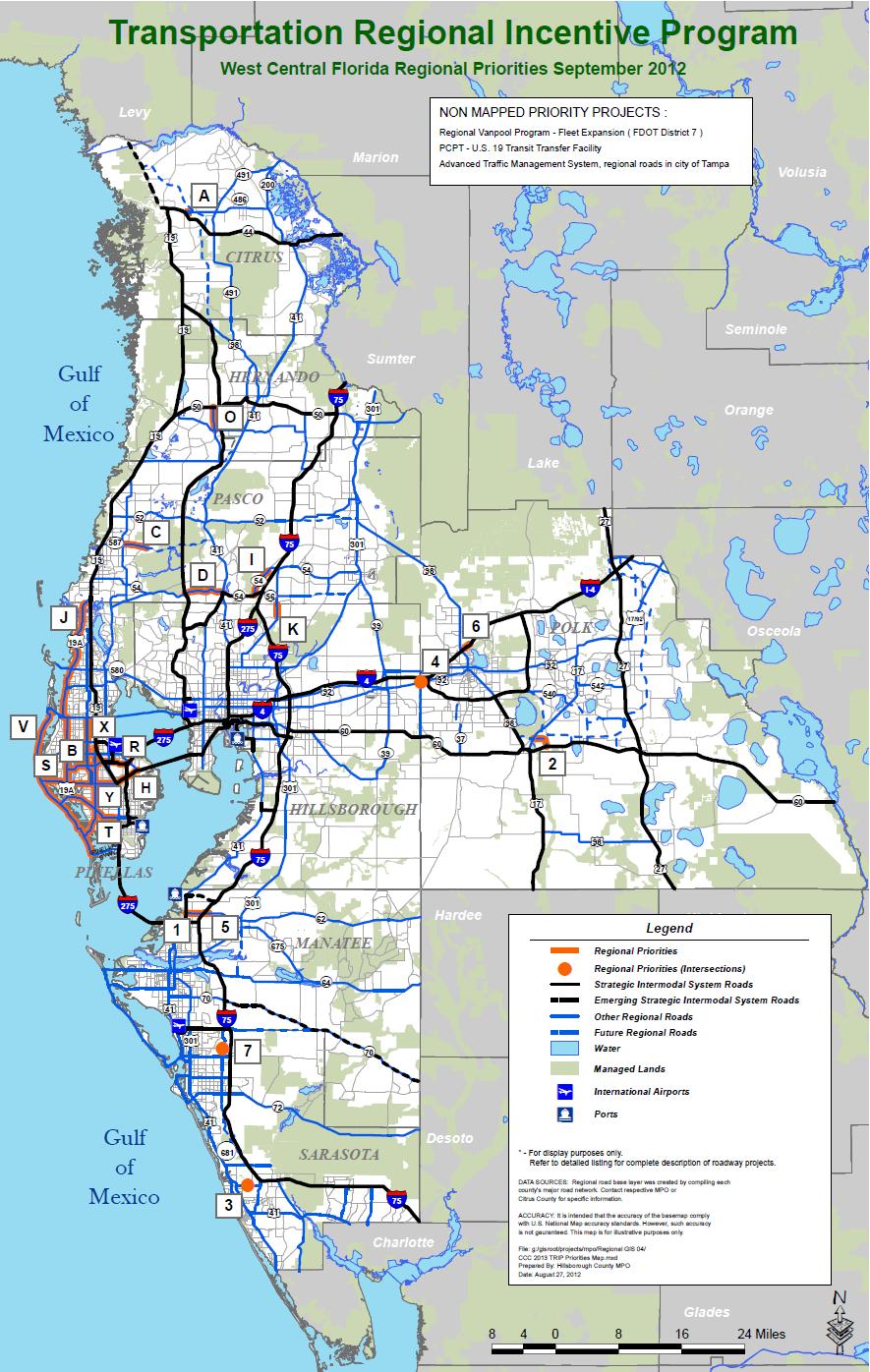
6 TRIP Regional Priorities
7 REGIONAL MULTI-USE TRAILS
8 Prioritization Process Priorities broken out by FDOT Districts 1 and 7 for consideration for FDOT statewide enhancement funds Each MPO/TPO or partner agency submitted projects that: Benefit regional connectivity Promote regional level bicycle/pedestrian mobility Projects are clearly identified with descriptions and cost estimates Previous successes: Suncoast Trail Courtney Campbell Causeway Trail


9 2012 Multi-Use Trails High Priority Projects DISTRICT 1 REGIONAL ENHANCEMENT PRIORITIES Priority Project Requesting Jurisdiction Limits/Phase Request 1 Peace River Trail City of Fort Meade 12 foot wide crushed lime rock trail along the Peace River corridor from Fort Meade Outdoor Recreation Area to Mount Pisgah Road. (2.3 miles) $909,000 2 Green Bridge Multi-Use Trail City of Bradenton Construct a multi-use trail addition to the Green Bridge between Bradenton and Palmetto. With the existing bridge, redesign and reduce lane widths for autos and increase safety for pedestrians and bicycles with wider lanes. $630,000 3 Haines City Trail (Phase II) Haines City 12 foot wide asphalt trail along rail bed from Grace Avenue to CR 544 then along CR 544 to 10th Street. $1,905,000 4 Legacy Trail Pedestrian Laurel Road Sarasota County Design and construct a trail overpass at Laurel Road. $560,000 5 Perico Island Preserve Trail Manatee County Design and construction of enhanced trail system for pedestrians and bicycles within the Perico Island Preserve. $100,000


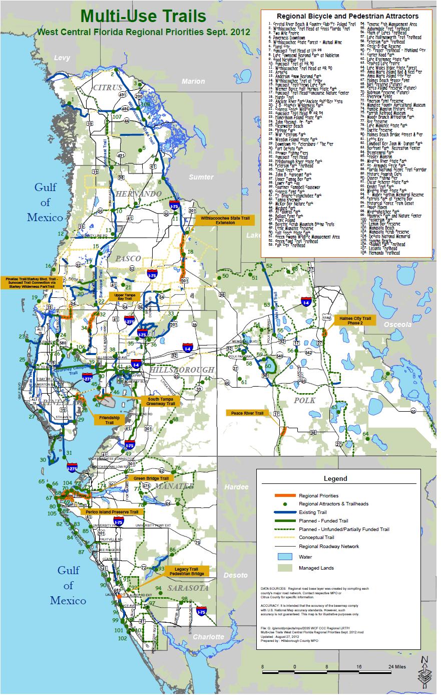
10 Multi-Use Trails Regional Priorities
11 HIGH PRIORITY MAJOR TRANSPORTATION INITIATIVES
12 HIGH PRIORITY MAJOR TRANSPORTATION INITIATIVES Priority Initiative are placed in ranked order. Facility Major regional corridors that serve the many travel markets which comprise West Central Florida. Multi-modal projects are grouped within these corridors based upon their role in meeting regional travel needs. Improvement Needed The improvement needed within each corridor is clearly defined. Rationale Each initiative has its own set of benefits for the region. This section describes how specific transportation improvements contribute to the area s continued mobility, safety and economic development.
13 HIGH PRIORITY MAJOR TRANSPORTATION INITIATIVES Materials related to regional projects were reviewed: TBARTA Master Plan Prioritization processes used in other regions, particularly MetroPlan Orlando. CCC s adopted 2035 Regional LRTP Criteria were used to assess the relative benefit of major regional projects: Mobility Safety Economic Development
14 High Priority Major Transportation Initiatives PRIORITY FACILITY LOCATION IMPROVEMENT NEEDED RATIONALE Based on Regional Mobility, Safety, and Economic Development #1 I-75 Hernando to Sarasota Widen to at least 6 general lanes, add managed lanes* with express bus stations and service The I-75 corridor is an economic lifeline for West Central Florida, connecting the region to state and national markets. Increasing its capacity will facilitate expanded movement of goods and services, through decreased travel times and increased access to potential customers and employees. Managed lanes are a proven method of increasing mobility options and providing economic development benefits for regional travel by decreasing travel times and improving access to major activity centers. Managed lanes also enhance the operation of alternative modes such as express bus; improve goods movement; increase connections to the region's intermodal network; and improve continuity of travel. #2 I-4/ I-275 Orlando - Tampa - Pinellas Add managed lanes* with express bus stations and service Inter-regional travel between our region and Orlando's will be significantly improved by constructing managed lanes along I-4. For the last 10 years, I-4 has consistently had traffic volumes in excess of 100,000. #3 Howard Frankland Bridge I-275 between Pinellas and Hillsborough Bridge replacement with transit envelope and intermodal centers Replacing this bridge offers an opportunity to provide for managed lanes and potential future rail, strengthening the most heavily travelled link between St Petersburg, Clearwater, Tampa and two international airports. The bridge currently carries 130,000+ trips per day, growing to 230,000+ in Adding new right-of-way to speed transit vehicles will make transit an attractive choice, reducing growth in congestion and crashes. Intermodal transfer centers at each end of the bridge will create seamless connections to local routes, Park & Ride and other options. #4 US 19 Pinellas to Pasco Controlled access & overpasses with express bus stations & service US 19 is a major north-south corridor for regional travel. New interchanges at high-crash intersections such as Curlew Rd will reduce delay and improve safety for a significant number of vehicles. Interchanges would also create a non-stop controlled access arterial from Pinellas Park through Clearwater and northward to Pasco County. Express bus service would also benefit from improved travel speeds and enhanced passenger convenience by placing transit stations at strategic locations along the corridor.
15 High Priority Major Transportation Initiatives PRIORITY FACILITY LOCATION IMPROVE-MENT NEEDED RATIONALE Based on Regional Mobility, Safety, and Economic Development #5 SR 54/56 New Port Richey to Wesley Chapel in Pasco Managed lanes* with transit accommodations In the 25 miles between congested Hillsborough Ave (SR 581) and SR 52, the SR 54/56 corridor is the only continuous east-west regional roadway that connects US 19 to I-75. Thus it is strategically positioned to form a Northern Loop that is currently a missing link in the regional roadway network. The SR 54/56 corridor intersects with B.B.Downs Blvd (SR 581), I-75, US 41, Suncoast Parkway, and US 19, with potential to extend eastward to US 301. Current plans call for completing the 6-laning of the corridor (Suncoast Parkway to US 41), and adding future capacity in the form of managed lanes. This corridor is a critical component of the Regional Loop System envisioned for the Tampa Bay area. Lane configuration and transit options are currently being studied by FDOT, with recommendations anticipated in late #6 US 41 Palmetto in Manatee to Northport in Sarasota Multimodal, transit and pedestrian improvements Two primary north-south travel corridors serve Manatee and Sarasota Counties: I-75 and US 41. The US 41 corridor is part of an urban core/spine traversing from the Port of Manatee in Northern Manatee County through the cities of Palmetto, Bradenton, Sarasota, Venice and North Port to the Charlotte County line. The Sarasota/Manatee MPO in its 2010 Long Range Transportation Plan (LRTP) prioritized over $200 million in Sarasota County and over $150 million in Manatee County over the next 25 years to improve modal options along this urban corridor. Such improvements include transit, bus stations, sidewalks, pedestrian crossings, intersection improvements, turn lanes, lighting and landscaping. No funds will be used for capacity (lane widening). These funds are not only intended for modal options but to spur economic investment and revitalization to this critical urban corridor.
16 High Priority Major Transportation Initiatives PRIORITY FACILITY LOCATION IMPROVEMENT NEEDED RATIONALE Based on Regional Mobility, Safety, and Economic Development #7 Suncoast Pkwy Corridor Hillsborough to Citrus New toll lanes with express bus stations & service Improvements on this major north/south corridor include: expanding capacity on the Veterans Expressway to 8 lanes north of Gunn Hwy; extending the Suncoast Parkway northward into Citrus County (Suncoast II) as a 4-lane facility, thereby providing relief for the US 19 and US 41 corridors; constructing express bus stations with park & ride facilities; and operating express bus service along the corridor. #8 Pinellas Alternatives Analysis (AA) St. Petersburg - Gateway - Clearwater Light rail connecting the Downtowns through the Gateway business district Transit improvements will promote mobility through viable alternatives to the single-occupant vehicle. The AA recommends light rail transit connecting the central business districts of St. Petersburg and Clearwater by way of an intermodal center in the Gateway area, a major employment district. The AA also recommends a connecting bus network to improve access to destinations around the county. Economic growth would be achieved through the provision of expanded mobility options and through the redevelopment potential at station areas and along bus routes. #9 CSX Corridor Hybrid Rail Tampa - Oldsmar - Land 'O Lakes - Brooksville Commuter Rail Orlando's SunRail project created a model for reuse of existing freight rail corridors through cities and suburbs. Another corridor owned by CSX connects Downtown Tampa and connects to Brooksville through the USF area and suburban central Pasco; spurs travel to MacDill AFB and through the suburbs of central Hillsborough and northern Pinellas. Commuter or hybrid rail service could be added on this corridor at a fraction of the cost of laying new light rail track, and potentially extended in the future to Tampa International Airport. An agreement between CSX and local, regional and state governments must be crafted.
17 High Priority Major Transportation Initiatives PRIORITY FACILITY LOCATION IMPROVEMENT NEEDED RATIONALE Based on Regional Mobility, Safety, and Economic Development #10 I-4 Rail Tampa to Orlando Extend SunRail The I-4 corridor is West Central Florida's main connection to the Central Florida super region. By placing commuter rail within the I-4 corridor and connecting to the 31 mile SunRail project being constructed in Orlando (extending to the community of Poinciana on the west end), a new means of accessing the many urban centers located along I-4 will be provided. Using existing rail lines, commuter rail can connect these intensive activity centers by providing a convenient option for longer distance travel. Opportunities for transit-oriented development around station areas are an important component of the economic benefits afforded by this project. *MANAGED LANES are special lanes generally for use by transit vehicles and/or carpools, with tolls for other vehicles. Details are determined through corridor studies.

18 High Priority Major Transportation Initiatives
19 NEXT STEPS September 14: CCC considers approving of draft for circulation/comment/ endorsement Presentations and discussions with TBARTA Board MPO Boards Regional Planning Councils Tampa Bay Partnership Interested others Revisions to draft CCC considers revised draft by 6/30/13 Distribute and advocate!
2012 PRIORITY TRANSPORTATION PROJECTS
 0 PRIORITY TRANSPORTATION PROJECTS The 0 Priority Transportation Projects include candidate road, congestion management, multi-use trail, transit, transportation regional incentive program (TRIP), county
EXISTING PRIORITIES FUNDED FOR CONSTRUCTION LRTP
 EXISTING PRIORITIES FUNDED FOR CONSTRUCTION Limits Description Status 1 415489 3 H1865 US HWY 301 FROM SR 674 TO BALM RD Widen 2 lanes to 6 lanes divided County / Construction Programmed 2016 2 405492
BOARD ACTION AGENDA ITEM #VI PROJECT PRIORITIES
 NOTES BOARD ACTION AGENDA ITEM #VI-2 2017 PROJECT PRIORITIES Presenter: Summary: Colleen McGue, Mike Maholtz, and Leigh Holt, MPO Staff Each year the MPO Board adopts an annual list of Priorities. Once
Performance Criteria for 2035 Long Range Transportation Plan
 Minimizing Impacts on Natural, Historic, Cultural or Archeological Resources 2035 LRTP Weighting Factor: 7% Objective 1.1: Use appropriate planning and design criteria to protect and enhance the built
US 41 COMPLETE STREETS CORRIDOR PLANNING STUDY from University Parkway to Whitfield Avenue
 41 US 41 COMPLETE STREETS CORRIDOR PLANNING STUDY from University Parkway to Whitfield Avenue EXECUTIVE SUMMARY DRAFT FEBRUARY 2019 Project Overview The US 41 Complete Streets Corridor Planning Study,
Gandy Connector: Travel Demand. Policy Committee August 2013
 Gandy Connector: Travel Demand Policy Committee August 2013 What options to the Gandy Elevated Lanes exist? What are the current conditions? Who s using Gandy Blvd? What s currently planned? What s been
CITY OF COCOA BEACH 2025 COMPREHENSIVE PLAN. Section VIII Mobility Element Goals, Objectives, and Policies
 CITY OF COCOA BEACH 2025 COMPREHENSIVE PLAN Section VIII Mobility Element Goals, Objectives, and Policies Adopted August 6, 2015 by Ordinance No. 1591 VIII MOBILITY ELEMENT Table of Contents Page Number
Chapter 5 Future Transportation
 Chapter 5 Future Transportation The Future Land Use Plan identifies the desired land use designations. The land uses desired for Crozet depend, in large part, on the success of the transportation system,
Linking Transportation and Health in Nashville & Middle Tennessee
 Linking Transportation and Health in Nashville & Middle Tennessee Fit Nation New Orleans CPPW Mentoring Grant Built Environment Program May 14, 2011 Local Transportation Planning Framework Federal U.S.
Governor s Transportation Vision Panel
 Office of Governor Kate Brown Governor s Transportation Vision Panel JLA Public Involvement Project Overview The is a yearlong effort to develop a series of recommendations for the Governor that address
Transportation Master Plan Advisory Task Force
 Transportation Master Plan Advisory Task Force Network Alternatives & Phasing Strategy February 2016 BACKGROUND Table of Contents BACKGROUND Purpose & Introduction 2 Linking the TMP to Key Council Approved
State Road 54/56 Tampa Bay s Northern Loop. The Managed Lane Solution Linking I-75 to the Suncoast Parkway
 State Road 54/56 Tampa Bay s Northern Loop The Managed Lane Solution Linking I-75 to the Suncoast Parkway SUNCOAST PARKWAY Both I 75 and the Suncoast Parkway are planning, or in the process of constructing,
Westshore Mobility Strategy Action Plan
 Westshore Mobility Strategy Hillsborough County Metropolitan Planning Organization P.O. Box 1110, 18th Floor Tampa, Florida 33601-1110 813/272-5940 FAX No. 813/272-6258 www.hillsboroughmpo.org TABLE OF
Orange County s Transportation Planning and Multimodal Corridor Plan
 Orange County Transportation Planning Division Orange County s Transportation Planning and Multimodal Corridor Plan Presentation to UCF LIFE November 11, 2014 Alissa Barber Torres, Ph.D., AICP, PLS Presentation
APPENDIX D: SACRAMENTO URBAN AREA TRANSPORTATION PRIORITIES
 1 County County County County 2 Yolo Arterial Roadway Collector Roadway Urban Residential Street Rural Residential Roadway I-80 / U.S. 50 Bus/Carpool Lanes in both directions Richards Blvd PM Yol 80 0.237
Chapter 7. Transportation. Transportation Road Network Plan Transit Cyclists Pedestrians Multi-Use and Equestrian Trails
 Chapter 7 Transportation Transportation Road Network Plan Transit Cyclists Pedestrians Multi-Use and Equestrian Trails 7.1 TRANSPORTATION BACKGROUND The District of Maple Ridge faces a number of unique
US HIGHWAY 19 CORRIDOR CONDITIONS, TRENDS, PLANNING ACTIVITIES. Pinellas County Metropolitan Planning Organization
 US HIGHWAY 19 CORRIDOR CONDITIONS, TRENDS, PLANNING ACTIVITIES Pinellas County Metropolitan Planning Organization September 9, 9 2015 US Highway 19 Conditions, i Trends, Planning Activities i i Traffic
CONNECTING PEOPLE TO PLACES
 CONNECTING PEOPLE TO PLACES 82 EAST BENCH MASTER PLAN 07 Introduction The East Bench transportation system is a collection of slow moving, treelined residential streets and major arteries that are the
The Florida Bicycle and Pedestrian Partnership Council
 The Florida Bicycle and Pedestrian Partnership Council Input to the Update of the Florida Transportation Plan March 2015 This document presents input from the Florida Bicycle and Pedestrian Advisory Council
Hennepin County Bicycle and Pedestrian Planning
 Hennepin County Bicycle and Pedestrian Planning 1 Value of bicycle and sidewalk systems Safety Livability Mobility Health Personal Finances Economic Sustainability Clean Air Recreation Parking and congestion
Florida Department of Transportation District Four. I-95 at 6 th Avenue Interchange Improvements FDOT PM - Fernando Morales, PE
 1 Florida Department of Transportation District Four I-95 at 6 th Avenue Interchange Improvements FDOT PM - Fernando Morales, PE Presentation Outline Overview of Planning and Programming I-95 Interchange
Safety Emphasis Areas & Safety Project Development Florida Department of Transportation District Seven Tampa Bay
 Safety Emphasis Areas & Safety Project Development Florida Department of Transportation District Seven Tampa Bay Stephen L. Benson, AICP, CNU-A FDOT District Seven Safety Office Presentation Overview Safety
Thank you for this opportunity to discuss with you how we can work together to make our streets more complete.
 Thank you for this opportunity to discuss with you how we can work together to make our streets more complete. 1 2 3 Thank you for this opportunity to discuss with you how we can work together to make
TAMPA BAY EXPRESS (TBX)
") TAMPA BAY EXPRESS (TBX) Hank Schneider, P.E. FDOT- District 7 Consultant Project Manager Florida Department of TRANSPORTATION TAMPA BAY EXPRESS AGENDA What is TBX? What does TBX do? Why is TBX Important?
TAMPA BAY EXPRESS (TBX) Hank Schneider, P.E. FDOT- District 7 Consultant Project Manager Florida Department of TRANSPORTATION TAMPA BAY EXPRESS AGENDA What is TBX? What does TBX do? Why is TBX Important?
Sarasota/Manatee MPO Project Priorities 2016 Adopted April 25, 2016
 All projects on the following priority lists should be implemented in the priority sequence listed, as consistent with the fiscal constraints identified in the MPO s adopted Long Range Transportation Plan
2015 Florida Main Street Annual Conference. Complete Streets Equal Stronger Main Streets
 WHAT ARE COMPLETE STREETS? CASE STUDIES COMPLETING YOUR MAIN STREET 2015 Florida Main Street Annual Conference St. Petersburg, Florida August 19, 2015 WHAT ARE COMPLETE STREETS? CASE STUDIES COMPLETING
City of Gainesville Transportation/Roadway Needs PROJECT SUMMARY
 A1 Roadway Resurfacing $23,846,000 TYPE: Preservation of existing system Roadway resurfacing A2 Signal Replacement $6,000,000 TYPE: Preservation of existing system Replace traffic signals. B1 W 6th St
MCTC 2018 RTP SCS and Madera County RIFP Multi-Modal Project Eval Criteria GV13.xlsx
 MCTC 8 RTP SCS and Madera County RIFP Multi-Modal Project Eval Criteria GV.xlsx Madera County Transportation Commission Regional Transportation Plan / Sustainable Communities Strategy Multi-Modal Project
FI N A N C I A L RESOURCER S REVIEW AND UPDATE M I A M I-DADE LO N G R A N G E TRANSPORT T ATION PLAN UPDATE TO THE YE
 Appendix B: Miami-Dade LRTP Cost Feasible Projects (Fully Funded and Partially Funded Projects) Fully Funded Projects Existing County roads O&M $317.9 $316.7 $811.5 Non Motorized set aside $27.9 $24.7
Florida DOT Case Study
 Florida DOT Case Study 1 Background In 2013, MetroPlan Orlando became one of the first planning agencies in the world to use Strava Metro data to make better decisions about where to improve bicycle and
City of Bartow Comprehensive Plan. Transportation Element
 City of Bartow 2030 Comprehensive Plan Amended through January 7, 2013 TRANSPORTATION ELEMENT GOAL: IT SHALL BE A GOAL OF THE CITY OF BARTOW TO PROVIDE A SAFE AND EFFICIENT MULTI-MODAL TRANSPORTATION SYSTEM
2025 Comprehensive Plan for the City of Temple Terrace Florida. Mobility Element. Adopted by City Council June 30, 2009
 2025 Comprehensive Plan for the City of Temple Terrace Florida Mobility Element Adopted by City Council June 30, 2009 Effective Date September 22, 2009 GOAL 2: To protect and promote the quality of life
APPENDIX A: Complete Streets Checklist DRAFT NOVEMBER 2016
 APPENDIX A: Complete Streets Checklist DRAFT NOVEMBER 2016 Complete Streets Checklist MetroPlan Orlando s Complete Streets Checklist is an internal planning tool for staff to further implementation of
Basalt Creek Transportation Refinement Plan Recommendations
 Basalt Creek Transportation Refinement Plan Recommendations Introduction The Basalt Creek transportation planning effort analyzed future transportation conditions and evaluated alternative strategies for
APPENDIX G: INTERSECTION NEEDS AT OKEECHOBEE BOULEVARD
 APPENDIX G: INTERSECTION NEEDS AT OKEECHOBEE BOULEVARD INTERSECTION NEEDS AT SR 7 and OKEECHOBEE BOULEVARD SR 7 Extension Project Development and Environment (PD&E) Study From Okeechobee Boulevard (SR
Corpus Christi Metropolitan Transportation Plan Fiscal Year Introduction:
 Introduction: The Safe, Accountable, Flexible, Efficient Transportation Equity Act: A Legacy for Users (SAFETEA-LU) has continued the efforts started through the Intermodal Surface Transportation Efficiency
Goal 3: Foster an environment of partnerships and collaboration to connect our communities and regions to one another.
 Non-Motorized Transportation Plan (NMTP) Draft Vision, Goal and,, Tri-County Regional Planning Commission (TCRPC) Purpose The purpose of the Tri-County Regional Planning Commission (TCRPC) Non-Motorized
Develop a Multi-Modal Transportation Strategy (Theme 6)
") DEVELOP A MULTI-MODAL TRANSPORTATION STRATEGY (THEME 6) WHY IS THIS THEME ADDRESSED? Develop a Multi-Modal Transportation Strategy (Theme 6) Statement of Ideal Reduce resident and visitor reliance on single
DEVELOP A MULTI-MODAL TRANSPORTATION STRATEGY (THEME 6) WHY IS THIS THEME ADDRESSED? Develop a Multi-Modal Transportation Strategy (Theme 6) Statement of Ideal Reduce resident and visitor reliance on single
Broward Boulevard Gateway Implementation Project, Downtown Walkability Analysis, & Joint Development Initiative (JDI)
") Broward Boulevard Gateway Implementation Project, Downtown Walkability Analysis, & Joint Development Initiative (JDI) City of Fort Lauderdale ~ Commission Conference July 10, 2012 Page 1 of 15 A Multi-Agency
Broward Boulevard Gateway Implementation Project, Downtown Walkability Analysis, & Joint Development Initiative (JDI) City of Fort Lauderdale ~ Commission Conference July 10, 2012 Page 1 of 15 A Multi-Agency
Tulsa Metropolitan Area LONG RANGE TRANSPORTATION PLAN
 Tulsa Metropolitan Area LONG RANGE TRANSPORTATION PLAN Indian Nations Council of Governments August 2005 CONTACTING INCOG In developing the Destination 2030 Long Range Transportation Plan, INCOG s Transportation
ACTIVE TRANSPORTATION
 ACTIVE TRANSPORTATION Mobility 2040 Supported Goals Improve the availability of transportation options for people and goods. Support travel efficiency measures and system enhancements targeted at congestion
Portland International Airport Bicycle and Pedestrian Plan (October 2003) Staff Acknowledgements
 Staff Acknowledgements") Portland International Airport Bicycle and Pedestrian Plan (October 2003) Staff Acknowledgements Scott King, Senior Aviation Planner Jason Gately, Senior Aviation Planner Preston Beck, Associate Planner
Portland International Airport Bicycle and Pedestrian Plan (October 2003) Staff Acknowledgements Scott King, Senior Aviation Planner Jason Gately, Senior Aviation Planner Preston Beck, Associate Planner
SR 693 (Pasadena Avenue) Corridor Study from Shore Drive South to 66 th Street
 Corridor Study from Shore Drive South to 66 th Street") Welcome and Introduction Sign-in and comment sheets Restrooms and exits Meeting agenda and timeline Meeting goals / expectations Provide input to guide study recommendations Actively participate throughout
Welcome and Introduction Sign-in and comment sheets Restrooms and exits Meeting agenda and timeline Meeting goals / expectations Provide input to guide study recommendations Actively participate throughout
Main-McVay Transit Study: Phase 2 Options Definition and High Level Constraints Evaluation
 Main-McVay Transit Study: Phase 2 Options Definition and High Level Constraints Evaluation APRIL 2016 A collaborative study between: For Additional Information or to Comment If you would like additional
Complete Streets Workshop Follow-up. April 27, 2011 Rockledge City Hall
 Complete Streets Workshop Follow-up April 27, 2011 Rockledge City Hall Agenda Complete Streets draft briefing presentation and sample policy language Share your Complete Streets projects and post workshop
Solana Beach Comprehensive Active Transportation Strategy (CATS)
") Solana Beach Comprehensive Active Transportation Strategy (CATS) 3.0 Goals & Policies The Solana Beach CATS goals and objectives outlined below were largely drawn from the Solana Beach Circulation Element
Solana Beach Comprehensive Active Transportation Strategy (CATS) 3.0 Goals & Policies The Solana Beach CATS goals and objectives outlined below were largely drawn from the Solana Beach Circulation Element
CITY OF BLOOMINGTON COMPLETE STREETS POLICY
 CITY OF BLOOMINGTON COMPLETE STREETS POLICY POLICY OBJECTIVE: The City of Bloomington will enhance safety, mobility, accessibility and convenience for transportation network users of all ages and abilities,
Circulation in Elk Grove includes: Motor vehicles, including cars and trucks
 Circulation, as it is used in this General Plan, refers to the many ways people and goods move from place to place in Elk Grove and the region. Circulation in Elk Grove includes: Motor vehicles, including
Roads and Vehicular Traffic Design Principles. Roads and Vehicular Traffic Recommendations
 CIRCULATION AND PARKING roads and vehicular traffic The Campus Master Plan updates the campus transportation network through a multi-modal approach that encourages walking and biking while improving vehicular
Chapter 6 Transportation Plan
 Chapter 6 Transportation Plan Transportation Plan Introduction Chapter 6 Transportation Plan Transportation Plan Introduction This chapter describes the components of Arvada s transportation system, comprised
City of Hamilton s Transportation Master Plan (TMP) Public Consultation 3 December 2015
 Public Consultation 3 December 2015") City of Hamilton s Transportation Master Plan (TMP) Public Consultation 3 December 2015 McPhail Transportation Planning Services Ltd. AGENDA 6:00 7:00 pm Viewing Boards / Q & A with the Team 7:00 7:50
City of Hamilton s Transportation Master Plan (TMP) Public Consultation 3 December 2015 McPhail Transportation Planning Services Ltd. AGENDA 6:00 7:00 pm Viewing Boards / Q & A with the Team 7:00 7:50
Perryville TOD and Greenway Plan
 Perryville TOD and Greenway Plan Greenway Glossary Pathway: A bicycle and pedestrian path separated from motorized vehicular traffic by an open space, barrier or curb. Multi-use paths may be within the
Route 7 Corridor Study
 Route 7 Corridor Study Executive Summary Study Area The following report analyzes a segment of the Virginia State Route 7 corridor. The corridor study area, spanning over 5 miles in length, is a multi
Appendix B. Transportation Analysis. B.1 Summary. East Nassau Employment Center DSAP
 Appendix B Transportation Analysis B.1 Summary This report presents the transportation analysis completed for the East Nassau Community Planning Area (ENCPA). The ENCPA is defined as 24,000 acres in Nassau
Pinellas County Metropolitan Planning Organization (MPO) 2014 Crash Data Report
 2014 Crash Data Report") Pinellas County Metropolitan Planning Organization (MPO) 2014 Crash Data Report MPO Board July 8, 2015 2 Crash Data Collection Motorcycle drove between stopped cars, ran a red light and collided with a
Pinellas County Metropolitan Planning Organization (MPO) 2014 Crash Data Report MPO Board July 8, 2015 2 Crash Data Collection Motorcycle drove between stopped cars, ran a red light and collided with a
US 19 Pedestrian and Bicycle Safe Access to Transit Corridor Study
 US 19 Pedestrian and Bicycle Safe Access to Transit Corridor Study Summary Report October 2016 Prepared for: FLORIDA DEPARTMENT OF TRANSPORTATION DISTRICT 7 (FDOT) Contract No: C 9B41, FAP No: 8886 318
Introduction. Project Need
 Introduction The purpose of Subtask 1 of the SR 54/56 Project Concept Development (PCD) Study is to identify and summarize the goals and proposed operations for transit corridor improvements as depicted
Plant City Walk-Bike Plan
 Plant City Walk-Bike Plan Plant City Commute Mode Share 2.2% 1.4% 2.9% Drove alone 10.2% Carpooled Public transportation (0.1%) Walked Used a Bike (0.4%) 82.9% Taxicab, motorcycle, or other means Worked
Planning Study SR 976. Project Advisory Team Meeting May 24, 2017
 ` SR 976 BIRD ROAD/SW 40TH STREET FROM SR 821/HEFT TO SR 5/US-1 Miami-Dade County, Florida FPID No.: 434845-4-22-01 Planning Study Project Advisory Team Meeting May 24, 2017 1 Agenda Introductions Project
Bicycle Lanes Planning, Design, Funding South Mountain Partnership Trails Workshop Roy Gothie PennDOT Statewide Bicycle Pedestrian Coordinator
 Bicycle Lanes Planning, Design, Funding 2018 South Mountain Partnership Trails Workshop Roy Gothie PennDOT Statewide Bicycle Pedestrian Coordinator Policy Changes: BOP Bicycle Policy Changes The OLD Way
2018 Transportation Alternatives Program (TAP) Application Presentation to Palm Beach TPA BRANT BRIDGE CONNECTION LOOP EXTENSION ON CARL BOLTER DR
 Application Presentation to Palm Beach TPA BRANT BRIDGE CONNECTION LOOP EXTENSION ON CARL BOLTER DR") 2018 Transportation Alternatives Program (TAP) Application Presentation to Palm Beach TPA BRANT BRIDGE CONNECTION LOOP EXTENSION ON CARL BOLTER DR Project Location N N Connecting South Delray Beach Existing
2018 Transportation Alternatives Program (TAP) Application Presentation to Palm Beach TPA BRANT BRIDGE CONNECTION LOOP EXTENSION ON CARL BOLTER DR Project Location N N Connecting South Delray Beach Existing
2016 TELL THE TPO SURVEY
 RIVER TO SEA TRANSPORTATION PLANNING ORGANIZATION 2016 TELL THE TPO SURVEY CAMPAIGN SUMMARY August 2016 Introduction The River to Sea Transportation Planning Organization (TPO) conducted its second Tell
Bicycle and Pedestrian Chapter TPP Update Overview. TAB September 20, 2017
 Bicycle and Pedestrian Chapter TPP Update Overview TAB September 20, 2017 Bicycling & Walking in the Twin Cities Where are we now? The Bike-Pedestrian system Current trends New developments Where are we
North Coast Corridor:
 North Coast Corridor: Connecting People, Transportation & Environment Legislative Hearing: 11.8.10 1 North Coast Corridor Region s Lifeline A Regional Strategy Mobility, Economy & Environment North Coast
US 19 PEDESTRIAN AND BICYCLE SAFE ACCESS
 US 19 PEDESTRIAN AND BICYCLE SAFE ACCESS TO TRANSIT CORRIDOR STUDY A JOINT EFFORT OF THE FLORIDA DEPARTMENT OF TRANSPORTATION AND FORWARD PINELLAS (F.K.A. PINELLAS COUNTY METROPOLITAN PLANNING ORGANIZATION)
SANTA CLARA COUNTYWIDE BICYCLE PLAN August 2008
 SANTA CLARA COUNTYWIDE BICYCLE PLAN August 2008 To assist VTA and Member Agencies in the planning, development and programming of bicycle improvements in Santa Clara County. Vision Statement To establish,
WELCOME TO OPEN HOUSE # 1 June 14, 2017
 Langstaff Road Weston Road to Highway 7 Class Environmental Assessment Study WELCOME TO OPEN HOUSE # 1 June 14, 2017 Please sign in and join our mailing list Purpose of Open House #1 & Study Area York
Florida Department of Transportation District 7 Pinellas County Metropolitan Planning Organization
 Florida Department of Transportation District 7 Pinellas County Metropolitan Planning Organization US 19 Pedestrian and Bicycle Safe Access to Transit Corridor Study Technical Memorandum #1 September 2015
Exhibit 1 PLANNING COMMISSION AGENDA ITEM
 Exhibit 1 PLANNING COMMISSION AGENDA ITEM Project Name: Grand Junction Circulation Plan Grand Junction Complete Streets Policy Applicant: City of Grand Junction Representative: David Thornton Address:
Chapter VISION, MISSION, AND GOALS AND OBJECTIVES. Vision. Mission. Goals and Objectives CONNECTING COMMUNITIES ACROSS THE ST.
 VISION, MISSION, AND GOALS AND OBJECTIVES Chapter 3 The Plan s vision, mission, and goals and objectives were developed through a series of interactive exercises with the Citizens Advisory Committee (CAC)
City of Atlanta-MARTA Sales Tax Referendum Draft Project List. Atlanta City Council Work Session May 19, 2016
 1 City of Atlanta-MARTA Sales Tax Referendum Draft Project List Atlanta City Council Work Session May 19, 2016 2 SB 369 - MARTA Sales tax for up to 0.50% is allowed in the City of Atlanta for MARTA Purpose
ARTINSVILLE ENRY OUNTY REA RANSPORTATION TUDY
 ARTINSVILLE ENRY OUNTY REA RANSPORTATION TUDY DEVELOPED BY THE TRANSPORTATION AND MOBILITY PLANNING DIVISION OF THE VIRGINIA DEPARTMENT OF TRANSPORTATION IN COOPERATION WITH THE U.S. DEPARTMENT OF TRANSPORTATION,
FM #: ETDM #: 11241
 SR 826/Palmetto Expressway PD&E Study From SR 93/I 75 to the Golden Glades Interchange FM #: 418423 1 22 01 ETDM #: 11241 Agency/ Kick Off Meeting October 27, 2011 2 Location Map From SR 93/I 75 to Golden
Highway 217 Corridor Study. Phase I Overview Report
 Highway 217 Corridor Study Phase I Overview Report November 3, 24 BACKGROUND AND OVERVIEW Study purpose The Highway 217 Corridor Study is developing multi-modal transportation solutions for traffic problems
21.07 TRANSPORT CONNECTIVITY AND INFRASTRUCTURE
 21.07 TRANSPORT CONNECTIVITY AND INFRASTRUCTURE 21.07-1 Connectivity and Choice Transport connectivity and mode choice are critical to achieving productive, sustainable and socially just cities. Travel
US 19 Pedestrian and Bicycle Safe Access to Transit Corridor Study
 US 19 Pedestrian and Bicycle Safe Access to Transit Corridor Study DRAFT Technical Memorandum #1 Baseline Conditions and Data Collection August 2016 Prepared for: FLORIDA DEPARTMENT OF TRANSPORTATION DISTRICT
COMPLETE STREETS A STEP FORWARD ITE District 10/FSITE Annual Meeting November 3, 2015
 COMPLETE STREETS A STEP FORWARD 2015 ITE District 10/FSITE Annual Meeting November 3, 2015 About Lakeland Incorporated: 1885 Population: 100,728 Area: Approx. 75 sq. mi Major Employers: Publix, Lakeland
Providing an Efficient and Multi-modal Transportation System
 Providing an Efficient and Multi-modal Transportation System Welcome and Introductions The Plan Process Transportation Overview Workshop Discussions Report Out and Next Steps AGENDA Comprehensive Plan
SR 9/I-95 Interchange at 45 th Street PD&E Study Palm Beach County, Florida FPID No.: FAP No.: ETDM No.
 SR 9/I-95 Interchange at PD&E Study Palm Beach County, Florida FPID No.: 436519-1-22-01 FAP No.: 0951-682-1 ETDM No.: 14225 Palm Beach County MPO October 19, 2017 SR 9/I-95 Interchange at PD&E Study Presentation
Needs Plan Report BAY COUNTY 2040 LONG RANGE TRANSPORTATION PLAN
 Needs Plan Report BAY COUNTY 2040 LONG RANGE TRANSPORTATION PLAN Prepared for Bay County Transportation Planning Organization and The Florida Department of Transportation, District Three Prepared by West
Chapter 2. Bellingham Bicycle Master Plan Chapter 2: Policies and Actions
 Chapter 2 Bellingham Bicycle Master Plan Chapter 2: Policies and Actions Chapter 2: Policies and Actions The Bicycle Master Plan provides a road map for making bicycling in Bellingham a viable transportation
C C C
 C-012-001 Thank you for your support for the creation of new public space and nonmotorized access between downtown and the waterfront through the Overlook Walk, the East-West Connections, and the Promenade.
2011 Capital Projects University Area - Community Council Priority List Municipality of Anchorage
 2011 Capital Projects University Area - Community Council Priority List Municipality of Anchorage 2 Project Management and Engineering Projects on 40th Ave Extension - Lake Otis Pkwy to Dale St $18,103,000
Modal Interrelationships: A bicycle lane is proposed between Harrington Ave and Swanns Station Rd.
 DRAFT PROJECT PAGE July 12, 2007 Main St / Broadway Rd (SR 1579) Project Statement Project Recommendation: From Avent Ferry Rd (NC 42) to the Harnett County line, Broadway Rd/Main St is recommended to
Prepared For: DIRECTION 2035 SHAPING OUR FUTURE SUMMARY REPORT JULY Prepared By: Staff to Bay County TPO
 Prepared For: DIRECTION 2035 SHAPING OUR FUTURE SUMMARY REPORT JULY 2012 Prepared By: Staff to Bay County TPO TPO Overview The Bay County Transportation Planning Organization (TPO) is a regional transportation
2045 Long Range Transportation Plan. Summary of Draft
 2045 Long Range Transportation Plan Summary of Draft Fredericksburg Area Metropolitan Planning Organization The George Washington Region includes the City of Fredericksburg and the counties of Caroline,
Hillsborough MPO List of Priority Projects 2016/2017 Transportation Improvement Program Table 1: EXISTING PRIORITIES FUNDED FOR CONSTRUCTION
 Hillsborough MPO List of s Table 1: EXISTING PRIORITIES FUNDED FOR CONSTRUCTION LRTP Number Limits Description Sponsor Status in /2016 TIP 415489 3 H1865 US HWY 301 FROM SR 674 TO BALM RD 405492 5 H300
CITY OF COCOA BEACH 2025 COMPREHENSIVE PLAN. Section VIII Mobility Element Goals, Objectives, and Policies
 CITY OF COCOA BEACH 2025 COMPREHENSIVE PLAN Section VIII Mobility Element Goals, Objectives, and Policies Adopted August 6, 2015 by Ordinance No. 1591 NOTES This entire element was reorganized and rewritten,
Road Diets FDOT Process
 Florida Department of TRANSPORTATION Road Diets FDOT Process Humberto Castillero, PE, PTOE Roadway Design Office Purpose of Guide Develop a statewide lane elimination review process Balance state & local
Proposed Project I 35 from Denton to Cooke County Line
 Proposed Project I 35 from Denton to Cooke County Line The existing I 35 facility is four lanes from I 35E/I 35W to Farm to Market Road (FM) 3002. The purpose of the proposed project is to increase capacity
ROUTES 55 / 42 / 676 BUS RAPID TRANSIT LOCALLY PREFERRED ALTERNATIVE
 ROUTES 55 / 42 / 676 BUS RAPID TRANSIT LOCALLY PREFERRED ALTERNATIVE April, 2012 1 INTRODUCTION The need for transit service improvements in the Routes 42/55/676 corridor was identified during the Southern
LANE ELIMINATION PROJECTS
 PRESENTATION OUTLINE Lane Elimination Considerations Districts 4 & 7 Draft Lane Elimination Processes FDOT Lane Elimination Guidelines Example Projects D4 Case Study: SR A1A (Ft. Lauderdale) D7 Case Study:
Attachment One. Integration of Performance Measures Into the Bryan/College Station MPO FY 2019 FY 2022 Transportation Improvement Program
 Attachment One Integration of Performance Measures Into the Bryan/College Station MPO FY 2019 FY 2022 Transportation Improvement Program Introduction Begun as part of the Moving Ahead for Progress in the
Moving Cambridge. City of Cambridge Transportation Master Plan Public Consultation Centre. March 7, :00 8:00 PM.
 City of Cambridge Transportation Master Plan Public Consultation Centre March 7, 2018 5:00 8:00 PM Region of Waterloo City of Cambridge Transportation Master Plan Public Consultation Centre March 7, 2018
Washington Metropolitan Area Transit Authority Board Action/Information Summary
 Washington Metropolitan Area Transit Authority Board Action/Information Summary Action Information MEAD Number: 200242 Resolution: Yes No TITLE: MWCOG Strategic Investment Plan & TPB Priorities PRESENTATION
US 1 Express Lanes Public Kick-Off Meeting
 US 1 Express Lanes Project Development & Environment (PD&E) Study Public Kick-Off Meeting September 7 & 8, 2011 Miami Dade County, Florida 1 Presentation Agenda Introduction to MDX Background to PD&E studies
Proposed. City of Grand Junction Complete Streets Policy. Exhibit 10
 Proposed City of Grand Junction Complete Streets Policy Exhibit 10 1 City of Grand Junction Complete Streets Policy Vision: The Complete Streets Vision is to develop a safe, efficient, and reliable travel
The Route 29 Corridor Study was initiated at the request of Virginia s Commonwealth
 CHAPTER 2: Study Background and approach The Route 29 Corridor Study was initiated at the request of Virginia s Commonwealth Transportation Board in response to requests from members of the General Assembly
A CHANGING CITY. of Edmonton, it is essential that it reflects the long-term vision of the City.
 A CHANGING CITY By the year 2040, Edmonton will be home to more than 1 million people. To accommodate growth and support a healthy and compact city, we need a new approach to development/redevelopment
Palm Beach MPO Complete Streets Working Group
 Palm Beach MPO Complete Streets Working Group March 23, 2016 www.palmbeachmpo.org 2300 North Jog Road 4 th Floor West Palm Beach, FL 33411 561 684 4170 Agenda What are Complete Streets? Welcome Complete