Item No. 8.1 Transportation Standing Committee February 1, 2018 February 22, 2018
|
|
|
- Posy Horn
- 5 years ago
- Views:
Transcription
1 P.O. Box 1749 Halifax, Nova Scotia B3J 3A5 Canada TO: SUBMITTED BY: Chair and Members of Transportation Standing Committee ORIGINAL SIGNED Kelly Denty, Acting Director: Planning & Development Item No. 8.1 Transportation Standing Committee February 1, 2018 February 22, 2018 ORIGINAL SIGNED Dave Reage, Director: Halifax Transit DATE: January 25, 2018 SUBJECT: Transit Priority Corridors: Gottingen Street / Bayers Road ORIGIN The Halifax Transit Moving Forward Together Plan, approved by Regional Council in April 2016, identified Bayers Road and Gottingen Street as critical choke points for transit service into and out of downtown Halifax that require transit priority. At the June 21, 2016 meeting of Regional Council, staff were directed to submit 16 proposed transit projects for cost-shared funding approval under the Public Transit Infrastructure Fund (PTIF). One of those projects proposed was the Transit Priority Corridors project. At the February 21, 2017 meeting of Regional Council, Halifax Regional Council authorized the Mayor and Municipal Clerk to sign the fifteen Contribution Agreements with the Minister of Municipal Affairs, to receive funding for public transit projects approved under the Public Transit Infrastructure Fund (PTIF), including one for the Transit Priority Corridors project. In May 2017, RFP was awarded to WSP Canada Inc. to prepare functional designs for Transit Priority Corridors on Bayers Road (Romans Avenue to Windsor Street) and Gottingen Street (North Street to Cogswell Street). At the December 5th, 2017 meeting of Regional Council, the Integrated Mobility Plan was approved, and staff were directed to include an implementation plan in the upcoming staff report for the Bayers Road and Gottingen Street Transit Priority corridors functional design to allow Council to consider construction in fiscal 2019/20. LEGISLATIVE AUTHORITY Transportation Standing Committee Terms of Reference, section 4 (a) which states: The Transportation Standing Committee shall oversee and review the Municipality s Regional Transportation Plans and initiatives, as follows: overseeing HRM s Regional Transportation Objectives and Transportation outcome Areas. Recommendation on page 2.
2 Transit Priority Corridors: Gottingen Street / Bayers Road Standing Committee Report February 1, 2018 Halifax Regional Municipality Charter, subsection 318(2): In so far as is consistent with their use by the public, the Council has full control over the streets in the Municipality. Halifax Regional Municipality Charter, subsection 322(1): The Council may design, lay out, open, expand, construct, maintain, improve, alter, repair, light, water, clean, and clear streets in the Municipality. RECOMMENDATION It is recommended that the Transportation Standing Committee recommend that Halifax Regional Council: 1. Proceed with detailed design of a dedicated northbound bus lane on the Gottingen Street corridor, including a Parking Loss Mitigation Plan which includes engagement with the public and stakeholders, and return to Council with a recommendation prior to tendering the project. 2. Proceed with detailed design of dedicated bus lanes in both directions on the Bayers Road corridor, including reconfiguration of the Halifax Shopping Centre intersection. EXECUTIVE SUMMARY The Halifax Transit Moving Forward Together Plan (MFTP), approved by Regional Council in April 2016, identifies Bayers Road and Gottingen Street as critical choke points for transit service that require transit priority. To improve transit service on these corridors, the MFTP recommends investment in transit priority measures (TPMs) that provide priority to the movement of buses over general traffic. These recommendations have been further reinforced by policy direction in the recently adopted Integrated Mobility Plan (IMP). When the IMP was adopted in December 2017, Regional Council also directed staff to include an implementation plan for Bayers Road and Gottingen Street so that Council could consider construction in fiscal 2019/20. The physical characteristics of the corridors, as well as how people use them, have a major influence on the type of transit priority measures that can be implemented. Also, as is typical with any project that involves reconfiguration of an existing street, there are trade-offs that need to be considered. Where rightof-way expansion is necessary, there may be impacts to utilities, private property, and other infrastructure. Loss of traffic lanes and curb access used for on-street parking, loading, and stopping may also be necessary. These impacts are consistent with the IMP, which notes that parking management should be aligned with the goal of shifting more trips to active transportation, transit and car-sharing, while supporting growth in the Regional Centre. Effectively managing the supply of parking can help to influence travel habits and improved parking efficiency can reduce the amount of space needed for parking. As an initial phase of detailed design, a Parking Loss Mitigation Plan will be carried out in consultation with local Gottingen Street businesses to help ensure that adequate short-duration parking is provided for this important commercial area. Following approval of the MFTP and securement of funding support from the Public Transit Infrastructure Fund (PTIF), a consultant was retained in May 2017 to complete a functional design study for transit priority corridors on Bayers Road and Gottingen Street. Multiple design options were completed for each corridor, representing a range of investment scenarios. The design options were evaluated based on various criteria that considered the potential to improve transit operation, multimodal impacts (walking, bicycling, traffic), curbside impacts (parking, loading), implementation cost, and the feedback received from stakeholders and the public. Analysis was also completed to relate capital / operational costs to operational benefits and develop an understanding of the cost-effectiveness of each option. Based on the findings of the functional design study, this report recommends that both the Bayers Road and Gottingen Street transit priority corridors be advanced to the detailed design stage. The recommended configuration for Gottingen Street includes a continuous northbound transit lane between Cogswell Street and North Street. The recommended configuration for Bayers Road includes continuous dedicated transit
3 Transit Priority Corridors: Gottingen Street / Bayers Road Standing Committee Report February 1, 2018 lanes in both directions between Romans Avenue and Windsor Street. These recommendations, which will provide considerable improvements for transit service, are in accordance with the objectives of the MFTP and the IMP. With approval of the recommendations in this report, the proposed transit priority corridors will move to the detailed design stage, which will provide further opportunity to refine the details of the corridor configuration and develop a comprehensive understanding of the implications of constructing the corridors. It is anticipated that detailed design will be completed using a combination of HRM staff resources and an external consultant, and will involve public and stakeholder engagement. Upon completion of the detailed design process, implementation will be subject to budget availability and approval of construction tenders by the CAO. A projected implementation timeline has been developed for both the Gottingen Street and Bayers Road corridors. The recommended Gottingen Street transit priority corridor does not require property acquisition or significant construction works; therefore, it is anticipated that implementation can be completed during The recommended Bayers Road transit priority corridor configuration will require property acquisition and involves extensive construction works it is possible that construction could be completed by 2020; however, there is potential that property acquisition could delay implementation beyond this timeframe. BACKGROUND The Halifax Transit Moving Forward Together Plan (MFTP), approved by Regional Council in April 2016, identifies Bayers Road and Gottingen Street as critical choke points for transit service into and out of downtown Halifax that require transit priority. To improve transit service on these corridors, the MFTP recommends investment in transit priority measures (TPMs) that provide priority to the movement of buses over general traffic. In February 2017, Regional Council directed staff to enter into a contribution agreement with the federal government, under the Public Transit Infrastructure Fund (PTIF), for a project to study and design Transit Priority Corridors on Bayers Road and Gottingen Street. The total project budget is $250,000, the cost of which is being shared evenly between the municipality and federal government. The project, CM Transit Priority Measures Corridor Study, is to be completed in two phases: a functional design study that identifies and evaluates design alternatives (Phase 1), followed by detailed design based on the preferred design options for the two corridors (Phase 2). In May 2017, RFP was awarded to WSP Canada Inc. (contract value $133,664) to prepare functional designs for transit priority corridors on Gottingen Street (North Street to Cogswell Street) and Bayers Road (Romans Avenue to Windsor Street), with the option to undertake the design of two further corridors pending direction from Regional Council through the Integrated Mobility Plan (IMP). On December 5, 2017, Regional Council approved the IMP, which includes direction to prioritize the delivery of transit priority corridors on Bayers Road, Gottingen Street, Robie Street, and Young Street. This report represents the conclusion of Phase 1 of this project. Gottingen Street: Gottingen Street is an arterial road that runs north-south between downtown Halifax and the north end of the Halifax peninsula. It has a diverse mixture of land uses, and recent, ongoing, and planned development projects are rapidly increasing the density of residential and commercial uses on the street. A key roadway linking downtown to the Macdonald Bridge and points further north, Gottingen Street has daily traffic volumes exceeding 8,500 vehicles per day. There is limited available right-of-way on Gottingen Street, and physical widening of the street or right-of-way is not a viable alternative. Transit on Gottingen Street
4 Transit Priority Corridors: Gottingen Street / Bayers Road Standing Committee Report February 1, 2018 There are currently 18 Halifax Transit routes that travel on Gottingen Street, totalling 79 buses per hour (2- way) during the peak hour. Planned changes in the MFTP will increase the number of buses using Gottingen Street to a total of 90 during the peak hour. Some routes along Gottingen Street provide limited stops, and two routes do not stop at all between Cogswell Street and North Street. Transit service on Gottingen Street is hindered by traffic congestion during peak periods, as well as by the need for buses to manoeuvre around vehicles stopped or parked in the curb lanes throughout the day. The relatively narrow street width makes these manoeuvres particularly challenging, and transit vehicles are delayed an average of 5-6 minutes in the northbound direction during the afternoon peak hour. These delays can be significantly higher when incident-related traffic congestion occurs. Bayers Road Bayers Road is an arterial road that runs east-west between Joseph Howe Drive and Windsor Street. It is characterized mostly by single family homes, and there are also several commercial properties found along the length of the corridor including the Halifax Shopping Centre. A key link in the regional roadway network, Bayers Road accommodates more than 40,000 vehicles per day. Traffic congestion is prevalent during peak periods, often resulting in significant delays. The 2014 Regional Municipal Planning Strategy identifies expansion of the Bayers Road corridor for mixed traffic as a planned project to occur in conjunction with expansion of Highway 102 (Hammonds Plains Road to Bayers Road) by the Province. Specifically, this includes widening from four lanes to six lanes west of Connaught Avenue and widening from three lanes to four lanes between Connaught Avenue and Windsor Street. Though the corridor expansion has not yet been programmed for implementation, for several years the Municipality has been making strategic property acquisitions along Bayers Road to preserve the corridor. At present, most of the properties on either side of the section of Bayers Road between Highway 102 and Connaught Avenue are owned by HRM. Transit on Bayers Road At present, seven Halifax Transit routes travel on Bayers Road, totalling more than 40 buses per hour (2- way) during the peak hour. Planned changes in the MFTP will increase the number of buses using Bayers Road during the peak hour. Traffic congestion on Bayers Road has significant impacts to transit and reduces Halifax Transit s ability to provide a high quality, reliable service. Routes on Bayers Road regularly experience significant delays during peak periods particularly during the afternoon and at present, some trips on the Route 1 detour in the outbound direction on Roslyn Road to reduce delay. Transit Priority Corridors Bayers Road and Gottingen Street were identified as proposed transit priority corridors in the MFTP based on their importance for existing and planned transit operations, as well as the potential that they are expected to offer for providing priority to transit over general traffic. The type of transit priority proposed for the corridors was not identified in the Plan, recognizing that there are many factors that need to be considered in determining a preferred approach. The physical characteristics of the corridors, as well as how people use them, have a major influence on the type of transit priority measures that can be implemented. Also, as is typical with any project that involves reconfiguration of an existing street, there are trade-offs that need to be considered. Where right-of-way expansion is necessary, impacts to private property and other infrastructure (e.g. water & sewer, power / communications lines, trees) may be required. Loss of traffic lanes and curb access used for on-street parking, loading, and stopping may also be necessary. These impacts are consistent with the IMP, which notes that parking management should be aligned with the goal of shifting more trips to active transportation, transit and car-sharing, while supporting growth in the Regional Centre. Effectively managing the supply of parking can help to influence travel habits and improved parking efficiency can reduce the amount of space needed for parking. As an initial phase of detailed design, a Parking Loss Mitigation Plan will be carried out in consultation with local Gottingen Street businesses to help ensure that adequate short-duration parking is provided for this important commercial area.
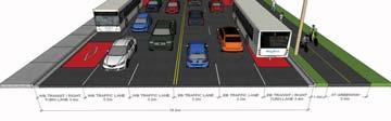
5 Transit Priority Corridors: Gottingen Street / Bayers Road Standing Committee Report February 1, 2018 DISCUSSION Following approval of the MFTP and securement of funding support from the Public Transit Infrastructure Fund (PTIF), Phase 1 of the project commenced after the selection of a consultant in May 2017 to complete a functional design study for the corridors. The primary objective of Phase 1 of the project was to investigate transit priority options and develop functional designs for transit priority corridors for Gottingen Street and Bayers Road. The scope of the consultant s work included the following: Detailed investigation of existing conditions along each corridor and review of existing and projected multimodal transportation demands; Develop 2-3 conceptual design options representing a range of investment levels with input from the project steering committee and feedback from stakeholders; Public and stakeholder engagement related to the proposed design concepts; Identify any necessary property acquisition and utility relocation requirements for each option Evaluate multimodal level of service for the options that considers factors such as transit operational benefits, intersection performance impacts, parking / curb access, and road safety. The consultant s findings and recommendations have been summarized in a design report appended to this report in Attachment E. An overview of the Gottingen Street and Bayers Road corridors and the options considered for each are provided in Attachment A and Attachment B, respectively. The recommended options are summarized in the following sections: Gottingen Street Analysis Approach and Identification of Preferred Configuration Options representing varying levels of investment (low, medium, and high) were considered for the proposed Gottingen Street transit priority corridor. A summary of the options that were considered is provided in Attachment A and further detailed in the consultant s report in Attachment E. The preferred configuration for the Gottingen Street transit priority corridor, as summarized in Table 1, includes a dedicated northbound transit lane. Further detail and functional design sketches are provided on Pages 5-7 (Attachment C). Table 1: Preferred Configuration Option Gottingen Street Transit Priority Corridor Functional Sketch Summary Cogswell Street to North Street Continuous outbound (northbound) lane for buses only (also permitted for use by right turning vehicles); Installation of pedestrian signals at key pedestrian crossings; Removal of on-street parking and loading Gottingen Street (looking to the south) Summary of Impacts: A summary of the impacts associated with the recommended transit priority corridor option for Gottingen Street is provided below: Transit Service: Significant transit improvement in the northbound direction. Buses avoid obstruction by parked cars and can bypass lengthy queues, reducing delay and improving reliability. It is estimated that these corridor-level transit priority measures will substantially reduce delay for northbound buses, benefiting approximately 1600 peak hour passengers over 56 trips.
6 Transit Priority Corridors: Gottingen Street / Bayers Road Standing Committee Report February 1, 2018 During heavily congested periods, it is estimated that buses will experience significant reductions in delay running times on Gottingen Street suggest that buses are regularly delayed by 5-6 minutes during the PM peak, and in some cases up to 15 minutes. The proposed transit priority corridor will enable buses to avoid these major delays, which will improve schedule adherence during congested periods and play an important role in making the service more attractive to users. Active Transportation: Minimal impacts. The addition of signalized crosswalks improves street crossing experience. Traffic Impacts: Slight improvement to traffic flow due to removal of on-street parking. Property Impacts: No impacts to private property. Parking / Loading: Removal of all on-street parking and loading on Gottingen Street (51 spaces). There may be potential to allow short-term parking or loading during overnight hours when buses are not running. A Parking Loss Mitigation Plan will be included in the detailed design stage of the project. Work on the plan has already begun and will include further engagement with local businesses. The plan will determine actual parking demand and will identify areas where it can be accommodated in the immediate vicinity, including additional parking on side streets. Summary of Stakeholder and Public Consultation Feedback: The Gottingen Street concept options were presented to the public at an Open House on Monday, October 2 nd, 2017, and a Shape Your City online consultation page was established. Feedback on the design options was obtained (via survey) from a total of 296 members of the public. Results are provided in Attachment D. The addition of transit priority on Gottingen Street was deemed favorable by more than 60% of survey respondents. Among the potential trade-offs associated with implementation of the presented options (parking / loading, traffic congestion, increased bus traffic, and implementation costs), the leading concerns were increased traffic congestion, loss of loading access, and increased bus traffic on the street. However, none of the trade-offs were deemed unacceptable by most respondents. HRM consulted with representatives from the North End Business Association (NEBA) on July 26 th, 2017, to introduce the project and develop an understanding of the priorities and concerns of the local business community. The NEBA is concerned about how the project may impact Gottingen Street businesses and raised the following items for consideration: The potential loss of on-street parking and loading on Gottingen Street and its perceived impact on the viability of local businesses: As noted above, the detailed design stage of the project will include a Parking Loss Mitigation Plan that includes a parking utilization study for Gottingen Street and the surrounding streets. While it is likely that there will be some net loss of on-street parking, this is consistent with curbside priority direction provided by the IMP, which prioritizes transit lanes over on-street parking and acknowledges the importance of replacing lost on-street parking where possible. Loading spaces will continue to be accommodated. The volume of buses that use Gottingen Street (existing and planned), and its perceived detrimental impact on the public realm: The public realm on Gottingen Street benefits from the significant number of people that buses bring to the street; this is also true for the businesses. Added transit priority will enable buses to move through the corridor more efficiently, thereby reducing the amount of bus idling on Gottingen Street while in traffic. The lack of consideration of alternatives that would reduce transit routing on Gottingen Street, including modified route configurations that could use alternate streets such as Barrington Street and Brunswick Street to service buses accessing the Macdonald Bridge (bus access to the bridge via these streets is constrained by the current ramp configuration): At present, Dartmouth bound buses must use Gottingen Street to access the Macdonald Bridge. Due to geometry on the Barrington Street ramp to the Macdonald Bridge, transit vehicles are unable to use this access. The Municipality and the Bridge Commission continue to work closely to investigate viable options that would permit this movement in a way that is safe, and enables buses to travel to Dartmouth from Halifax via Barrington Street. Interventions may be limited to small changes to the geometry of some road markings, however it is possible that it could require larger changes to the bridge ramp, which may be extremely costly.
7 Transit Priority Corridors: Gottingen Street / Bayers Road Standing Committee Report February 1, 2018 Bayers Road However, even if the Barrington Street ramp did provide access for Dartmouth bound buses to the bridge, transit priority is still warranted on Gottingen Street for the buses which would still serve the many residents and businesses on this important corridor. There is high passenger demand on Gottingen Street: and this area is very walkable and is characterized by businesses and services which attract transit passengers and pedestrians alike. If the Barrington Street ramp were to be accessible to transit vehicles, only routes that do not currently make stops on Gottingen Street would benefit. Brunswick Street is not considered a candidate for routing transit vehicles at this time. This street is a local street between Cogswell Street and North Street with lower traffic volumes, and the character of the street is largely residential. It lacks the commercial usage that Gottingen Street has, and thus does not have the same trip demand, attractions, or destinations. It is not currently possible for any vehicles to access the Macdonald bridge from Brunswick Street. At best, with the necessary intersection modifications at North Street, Brunswick Street could only accommodate buses travelling to Dartmouth and would not eliminate the need for transit priority on Gottingen Street. Analysis Approach and Identification of Preferred Configuration Bayers Road was analyzed based on three distinct sections: (i) Romans Avenue to Halifax Shopping Centre, (ii) Halifax Shopping Centre and Connaught Avenue, and (iii) Connaught Avenue to Windsor Street. Multiple options representing varying levels of investment (low, medium, and high) were considered for the configuration of the proposed transit priority corridors for each section of Bayers Road. A summary of the options that were considered is provided in Attachment B and further detailed in the consultant s report in Attachment E. The preferred configuration for each of the three sections of Bayers Road are summarized in Table 2. Further detail and functional design sketches are provided on Pages 1-4 (Attachment C).
 Summary Widen from existing 4-lane cross section to a 6- lane cross section; Add continuous eastbound and")
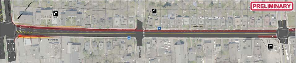
8 Transit Priority Corridors: Gottingen Street / Bayers Road Standing Committee Report February 1, 2018 Table 2: Preferred Configuration Options Bayers Road Transit Priority Corridor Romans Avenue to Halifax Shopping Centre Functional Sketch Bayers Road (looking to the east) Summary Widen from existing 4-lane cross section to a 6- lane cross section; Add continuous eastbound and westbound dedicated bus lanes (also permitted for use by right turning vehicles); Add a multi-use pathway on the south side of Bayers Road; Most of required land has already been acquired by HRM, though more property acquisition will be required. Halifax Shopping Centre to Connaught Avenue A Add One-way Connection Bus Lanes (typ.) No Left Turns to Shopping Centre Left turns into Halifax Shopping Centre prohibited from Bayers Road, removing key source of congestion. Add new one-way driveway connection to the Halifax Shopping Centre across HRM-owned vacant parcel. New connection provides increased capacity for traffic entering the Halifax Shopping Centre. Further consultation with the Halifax Shopping Centre will be required. Add continuous eastbound and westbound dedicated bus lanes (also permitted for use by right turning vehicles); Multi-use Path Halifax Shopping Centre Widen from existing 3-lane cross section to a 4- lane cross section; Connaught Avenue to Windsor Street Add continuous eastbound and westbound dedicated bus lanes (also permitted for use by right turning vehicles); Property acquisition will be required. Several properties are affected, though it is not anticipated that impacts will be extensive. Removal of onstreet parking and loading. Bayers Road (looking to the east) Summary of Impacts: A summary of the impacts associated with the recommended transit priority corridor option for Bayers Road is provided below: Transit Service: Significant transit improvement in both directions, as buses avoid the traffic congestion that frequently occurs during peak periods. For example, it is estimated that these corridor-level transit priority measures will substantially reduce delay for outbound buses during the PM peak running times on Bayers Road suggest that buses are regularly delayed by minutes during the PM peak, and in some cases by up to 28 minutes (these improvements would benefit approximately 530 peak hour passengers, over 25 trips). The proposed transit priority corridor will enable buses to avoid these major delays, which will improve schedule adherence during congested periods and play an important role in making the service more attractive to users. Active Transportation: Multi-use path west of Connaught Avenue provides improved walking / cycling connection. Traffic Impacts: Slight improvement to traffic flow due to removal of buses from general traffic and decreased delay at the reconfigured Halifax Shopping Centre driveway intersection. The closely spaced intersections at Connaught Avenue and Bayers Road would benefit considerably from the intersection configuration, reducing confusion and operational challenges for all users.
9 Transit Priority Corridors: Gottingen Street / Bayers Road Standing Committee Report February 1, 2018 Property Impacts: Widening in constrained areas will require property acquisition. West of the Halifax Shopping Centre, most of required land has already been acquired by HRM, though more property acquisition will be required. East of Connaught Avenue, several properties may be affected, though the majority will not be significantly impacted (narrow strips of property frontage required). Parking / Loading: Loss of approximately 50 on-street parking spaces on Bayers Road between Connolly Street and Dublin Street. Summary of Stakeholder and Public Consultation Feedback: The Bayers Road corridor concept options were presented to the public at an Open House on Thursday, September 28 th, and a Shape Your City online consultation page was established. Feedback on the design options was obtained (via survey) from a total of 488 members of the public. Results are provided in Attachment D. The addition of dedicated bus lanes on Bayers Road received a favorable response from more than 70% of respondents. Among the potential trade-offs associated with implementation of the presented options (property impacts, parking / loading, traffic congestion, increased bus traffic, and implementation costs), the potential for increased traffic congestion was the lone category that most respondents (54%) indicated was unacceptable. HRM consulted with representatives from the Halifax Shopping Centre to review the concept options as they relate to the shopping centre driveway intersection. Based on preliminary feedback, Halifax Shopping Centre representatives have concerns about potential modifications to the existing access configuration, but indicated that they are open to further consultation as the project progresses. Recommended Approach for the proposed Transit Priority Corridors: It is recommended that both the Bayers Road and Gottingen Street Transit Priority Corridors be advanced to the detailed design stage. The recommended configuration for each corridor is described below: Gottingen Street: Continuous northbound transit lane between Cogswell Street and North Street. Since the Gottingen Street options are quite scalable (most of the changes include modifications to signage, signals, and pavement markings and do not require land acquisition or have significant impacts to physical infrastructure), the recommended option could be modified relatively easily depending on how the facility operates and/or how its impacts to the street are perceived. Consideration could also be given to permitting on-street parking in the transit lane during specific periods with limited transit service such as overnight. Recommendations from the Parking Loss Mitigation Plan noted above will be included in the detailed design. Bayers Road: Dedicated bus lanes (both directions) on Bayers Road between Romans Avenue and Windsor Street, and reconfiguration of the Halifax Shopping Centre intersection to include a new atgrade access leg via the HRM-owned vacant property at 6699 Bayers Road. During the detailed design process, further investigation should be completed to determine a preferred intersection configuration for the Halifax Shopping Centre driveway. Consultation with representatives from the Halifax Shopping Centre should also be continued during the design process. Next Steps / Implementation Plan At the February 21, 2017 meeting of Regional Council, Halifax Regional Council directed staff to provide an implementation plan for the Gottingen Street and Bayers Road corridors that allows consideration of the potential for construction during the fiscal year. The following describes the next steps that are anticipated to be required for implementation of both corridors. Gottingen Street: Based on Regional Council approval of the recommendations outlined in this report, an approximate implementation timeline is summarized in Table 3. Detailed design of the transit priority corridor will be completed by HRM staff. During detailed design, public and stakeholder engagement will be completed to provide opportunity for additional feedback on the design and related impacts.
10 Transit Priority Corridors: Gottingen Street / Bayers Road Standing Committee Report February 1, 2018 Implementation of the recommended Gottingen Street transit priority corridor does not require property acquisition or significant construction works; therefore, it is anticipated that implementation can be completed during Table 3: Estimated Implementation Timeline - Gottingen Street Transit Priority Corridor 1. Detailed Design a b Task 2018 J F M A M J J A 2. Construction Tendering 3. Award of Construction Tender c 4. Construction Notes: a. Assumes Regional Council approval of staff recommendations in February b. Detailed design completed by HRM Planning & Development and Transportation & Public Works. c. CAO award of construction tender will be subject to budget availability. Bayers Road: Based on Regional Council approval of the recommendations outlined in this report, an approximate implementation timeline is summarized in Table 4. Implementation of the Bayers Road transit priority corridor is significantly more complex than for Gottingen Street, and will require additional time, budget, and resources. Due to the anticipated need to acquire private property, there is also more schedule uncertainty. A consultant will be retained to complete detailed design. During detailed design, public and stakeholder engagement will be completed to provide opportunity for additional feedback on the design and related impacts. Based on the detailed design, property acquisition requirements will be identified, and a construction budget estimate will be developed. The process of acquiring private property will have uncertain timelines that could delay the project. Award of a construction tender by the CAO will be required, subject to budget availability. Construction timelines are also uncertain, though it is expected that at least 3-4 months will be required. Based on the estimated implementation timeline, it appears possible that construction of the proposed Bayers Road transit priority corridor can be completed by However, it is noted that certain elements of the implementation process primarily property acquisition do have the potential to delay the project to 2021 or beyond.
11 Transit Priority Corridors: Gottingen Street / Bayers Road Standing Committee Report February 1, 2018 Table 4: Estimated Implementation Timeline - Bayers Road Transit Priority Corridor Task Winter Spring Summer Fall Winter Spring Summer Fall Winter Spring Summer Fall 1. Issue and Award RFP for Detailed Design a 2. Detailed Design b 3. Property Acquisition c 4. Construction Tendering 5. Award of Construction Tender d 6. Construction e Notes: a. Assumes Regional Council approval of staff recommendations in February b. c. Detailed design completed by consultant. Property acquisition requirements will be determined based on the detailed design. The process of acquiring private property has uncertain timelines, and may vary considerably depending on the amount of property required. d. CAO award of construction tender will be subject to budget availability. e. Construction timelines for this project are uncertain. Mitigation of construction-related impacts on traffic will likely be desired due to the siginificance of the Bayers Road corridor. It has been assumed that construction will commence during spring, coinciding with the start of the road construction season. Robie Street / Young Street: As recommended in the IMP, transit priority corridors are also being investigated on Robie Street and Young Street. Staff are currently working with WSP Canada Inc. on a functional design study for the two corridors. The design process will include public engagement in February Upon completion of the functional design study, a recommendation report will be submitted to Regional Council seeking direction to proceed to detailed design for a recommended corridor configuration. This report will also describe an estimated timeline for implementation of these corridors, which may include phasing. It is anticipated that the report will be submitted to Regional Council in spring FINANCIAL IMPLICATIONS The evaluation of the corridor options considered both capital and operating costs relative to operational benefits in identifying a preferred, cost-effective approach. The detailed design for Bayers Road will be funded from CM Transit Priority Measures Corridor Study, the cost of which is estimated to be within the balance of $116,336 available in the project account. The Bayers Road detailed design is funded through the Public Transit Infrastructure Fund (PTIF), which provides up to 50% of the project costs. The detailed design work for Gottingen Street will be undertaken by HRM staff resources at no additional cost to the Municipality. Budget Summary: Project Account No. CM Transit Priority Measures Corridor Study Cumulative Unspent Budget $ 116,336 Less: estimated detailed design cost $(116,336) Balance $ 0 The Gottingen Street transit priority corridor construction work estimated at approximately $250,000, but subject to detailed design will be funded from project account CM000009, Transit Priority Measures, pending the approval of the 2018/19 capital budget.
12 Transit Priority Corridors: Gottingen Street / Bayers Road Standing Committee Report February 1, 2018 Budget Summary: Project Account No. CM Transit Priority Measures Cumulative Unspent Budget $392,390 Anticipated 2018/19 Budget $350,000 Less: estimated construction cost $(250,000) Balance $ 492,390 Construction of the recommended Bayers Road transit priority corridor is not budgeted at this time the preliminary Class D cost estimate for construction, excluding property acquisition, is $4.8 million but the design will allow tender/construction to proceed when the funding opportunity/decision occurs. RISK CONSIDERATION There are no significant risks associated with the recommendations of this report. The risks considered rate low. COMMUNITY ENGAGEMENT Stakeholder and public consultation was completed to develop an understanding of the key issues on each corridor and solicit feedback on the presented concept designs. Stakeholder consultation sessions were held with the following groups: - North End Business Association - Halifax Shopping Centre (20Vic Management) - Halifax Cycling Coalition - It s More Than Buses - Walk & Roll - Canadian National Institute for the Blind (CNIB) - Dalhousie Transportation Collaboratory (DalTrac) The information obtained from these groups was considered during the development of the design options, and incorporated into the options evaluation process. Public open consultation sessions were held for each of the Gottingen Street and Bayers Road corridors: - Bayers Road: Thursday, September 28 th Maritime Hall - Gottingen Street: Monday, October 2 nd George Dixon Centre In addition, a Shape Your City online engagement portal was established for each corridor. Feedback was collected via in-person comments, a paper feedback survey, and an online survey (there were a total of 488 respondents for the Bayers Road survey, and 296 respondents for the Gottingen Street survey). The information obtained from public consultation was used to develop an understanding of priorities on each corridor and evaluate public response to the design options. Survey results are summarized in Attachment D. Further engagement with Gottingen Street businesses, relative to on-street parking and loading impacts and the Halifax Shopping Centre, relative to its intersection at Bayers Road, will continue for both projects as they proceed through the detailed design process. ENVIRONMENTAL IMPLICATIONS This project is supportive of the Council Priority Outcome of building Healthy, Livable communities, as it aims to make it more convenient for residents to choose sustainable transportation options for everyday transportation purposes. This is reflected in the enhancements for transit, but also the improvements for
13 Transit Priority Corridors: Gottingen Street / Bayers Road Standing Committee Report February 1, 2018 pedestrians and cyclists. ALTERNATIVES The Transportation Standing Committee may recommend to Regional Council that some or all of the recommendations not be approved or be modified. Alternatives for each of the Gottingen Street and Bayers Road and corridors are presented below: Gottingen Street: 1. The Committee may recommend that Regional Council direct staff to introduce a 12-month pilot of a northbound transit lane on Gottingen Street in order to observe and monitor the impacts it may have on transit service reliability as well as local businesses and residents. This alternative is not recommended, as the transit benefits of the proposed measures are well understood at this time, and more than 60% of consultation survey respondents showed support for the measures. 2. The Committee may recommend that Regional Council direct staff to proceed to detailed design of intermittent transit priority measures in the northbound direction. This alternative is not recommended; while it does provide transit priority benefits, the overall transit benefit is considerably less than the continuous priority included in the high investment option, and the additional cost is only marginally lower. 3. The Committee may recommend that Regional Council direct staff to implement peak period parking / loading restrictions or recommend that no changes be made to the Gottingen Street corridor. These alternatives are not recommended, as they do not provide transit priority benefits contemplated by the MFTP and IMP. Bayers Road: 1. The Committee may recommend that Regional Council direct staff to proceed to detailed design of dedicated bus lanes (both directions) on Bayers Road without reconfiguration to the Halifax Shopping Centre intersection. This alternative is not recommended, as it is not expected that effective transit priority can be provided through the section between Halifax Shopping Centre and Connaught Avenue under the existing intersection configuration. 2. The Committee may recommend that Regional Council direct staff to proceed to detailed design of a dedicated westbound bus lane on Bayers Road between Romans Avenue and Windsor Street. This alternative is not recommended, since it provides transit priority only in the outbound direction and does not achieve the benefits contemplated by the MFTP and IMP. 3. The Committee may recommend that Regional Council make no changes to the Bayers Road corridor. This alternative is not recommended, as it does not achieve the benefits contemplated by the MFTP and IMP. ATTACHMENTS Attachment A: Gottingen Street Summary and Design Options Overview Attachment B: Bayers Road Summary and Design Options Overview Attachment C: Functional Design Drawings Attachment D: Community Consultation Results Summary Attachment E: Halifax Transit Priority Corridors: Gottingen Street and Bayers Road (WSP, November 2017) A copy of this report can be obtained online at halifax.ca or by contacting the Office of the Municipal Clerk at Report Prepared by: Mike Connors, P.Eng., Transportation Engineer, Planning & Infrastructure, Report Approved by: Patricia Hughes, Manager Planning & Scheduling, Halifax Transit Report Approved by: Peter Duncan, Manager Infrastructure Planning, Planning & Development,
14 Charles Buddy Daye Cunard Uniacke Prince William Attachment A: Gottingen Street Summary and Options Overview Page A-1 Attachment A: Gottingen Street Summary and Options Overview The Gottingen Street corridor was investigated between North Street and Cogswell Street (See Figure 1). N Gottingen Gottingen Figure 1: Gottingen Street Corridor Table 1: Existing Conditions Gottingen Street Corridor Key arterial street that provides a north-south connection between downtown Halifax and the bridge, as well as the north end and beyond Vehicle Traffic Pedestrians / Cyclists Transit Property Ownership Adjacent Land Uses Parking and Loading Two lanes south of Uniacke Street Three lanes (2 northbound, 1 southbound) between Uniacke Street and North Street Walking: An urban street with a diverse mixture of land uses, Gottingen Street is a busy pedestrian area. There are sidewalks on both sides of the street, though sidewalk width and separation from traffic lanes are limited by the narrow available right-of-way. Cycling: Gottingen Street does not have any current or planned bicycle facilities. With a relatively narrow cross section and extensive transit service, it is not considered an ideal cycling route. The Gottingen Street Corridor is served by the following routes at peak: 1, 7, 10, 11, 21, 31, 33, 34, 41, 53, 59, 61, 68, 86, 159, 320, 330, and 370. This is a total of approximately 79 trips at in the peak hour. The biggest impediment to bus operation on Gottingen Street is interaction with vehicles parked or stopped along the curb, which requires buses to awkwardly manoeuvre to get by them. The narrow curb-to-curb width exacerbates the challenges, often disrupting the flow of traffic in both directions. Available right-of-way along Gottingen Street is very limited. The typical curb-to-curb width is 10m, and building setbacks on both sides are typically very tight. It is not expected that property acquisition for the purposes of widening to expand the street is a viable approach. Diverse mix of residential and commercial There are approximately 51 on-street parking spaces on Gottingen Street between Cogswell Street and Uniacke Street, all of which are time-limited (peak period, peak direction parking is restricted). Loading activities are completed from the existing parking spaces, in addition to one designated loading zone and any other locations not designated as No Stopping.
, advantages, and disadvantages for the options")

15 Attachment A: Gottingen Street Summary and Options Overview Page A-2 The design options presented in Table 2, which represent varying levels of investment, were developed for Gottingen Street. Functional design drawings, along with an overview of the implications (transit improvements and impacts to traffic, parking, and adjacent land uses), advantages, and disadvantages for the options for each section are provided on Pages 5 to 7, Attachment C. Table 2: Design Options Gottingen Street Corridor Description Summary of Impacts Low Investment: Peak Period Parking / Stopping Restrictions No explicit transit priority measures Parking and stopping restricted on both sides of the street during AM and PM peak periods Transit Service: Does not provide priority for buses over general traffic, though transit delays may improve due to improvements to general traffic flow Walking: No impact. Bicycling: Minimal impact. Fewer conflicts with parked vehicles. Traffic Impacts: Improved traffic flow during AM and PM peak periods. Property Impacts: No impact. Parking / Loading: Removal of all onstreet parking and loading on Gottingen Street during peak periods only. Medium Investment: Intermittent Outbound Transit Priority Measures Installation of transit queue jump lanes at key locations; Installation of pedestrian half signals at key pedestrian crossings; Transit Service: Transit priority at key locations provide moderate service improvement. Walking: Minimal impact. The addition of signalized crosswalks improves street crossing experience. Bicycling: Minimal impact. Fewer conflicts with parked vehicles. Traffic Impacts: Improved traffic flow during AM and PM peak periods. Property Impacts: No impact. Parking / Loading: Removal of all onstreet parking and loading on Gottingen Street during peak periods only. High Investment: Continuous Outbound Transit Priority Lane Continuous outbound (northbound) lane for buses only (also permitted for use by right turning vehicles); Installation of pedestrian half signals at key pedestrian crossings; Transit Service: Continuous bus lane and transit priority lane provides significant service improvement. Walking: Minimal impact. The addition of signalized crosswalks improves street crossing experience. Bicycling: Minimal impact. Fewer conflicts with parked vehicles. Traffic Impacts: Improved traffic flow during AM and PM peak periods. Property Impacts: No impact. Parking / Loading: Full-time removal of all on-street parking and loading on Gottingen Street
16 Attachment B: Bayers Road Summary and Options Overview Page B-1 Attachment B: Bayers Road Summary and Options Overview Bayers Road Due to the varying widths and conditions found along the Bayers Road corridor, for the purposes of this investigation it has been separated into the following three distinct sections (illustrated in Figure 1). 1. Romans Avenue to Halifax Shopping Centre 2. Halifax Shopping Centre to Connaught Avenue 3. Connaught Avenue to Windsor Street N Halifax Shopping Centre Figure 1: Bayers Road Corridor Table 1 summarizes existing conditions for the three sections of Bayers Road related to vehicular traffic, active transportation, transit, property ownership, adjacent land uses, and parking / loading.
17 Attachment B: Bayers Road Summary and Options Overview Page B-2 Table 1: Existing Conditions Bayers Road Corridor Vehicle Traffic Pedestrians / Cyclists Transit Property Ownership Adjacent Land Uses Parking and Loading Romans Avenue to Halifax Shopping Centre Halifax Shopping Centre to Connaught Avenue Four lanes (2 lanes each direction) separated by a median Heavy traffic volumes and high delays during AM / PM peak periods 5-6 lanes (including turn lanes to Halifax Shopping Centre) Short separation (approx. 100m) between Shopping Centre intersection and Connaught Avenue results in spillback of queues, causing congestion. Interaction of queues between intersections complicates access to local land uses including Halifax Shopping Centre. Walking: Though there are existing sidewalks, it is not an ideal walking environment due to heavy traffic volumes and a lack of separation between the sidewalk and traffic lanes, which reduces comfort for pedestrians. Cycling: Not currently an ideal cycling route due to heavy traffic volumes and lack of dedicated space for bicycles. The Active Transportation Priorities Plan envisions a multi-use path connection on the south side of Bayers Road between Vaughan Avenue and George Dauphinee Avenue, which would bypass Bayers Road. However, HRM Active Transportation Staff have expressed interest in the potential to integrate a multi-use path extending west of Vaughan Avenue on Bayers Road if right-ofway widening is considered. Used by routes 2, 17, 80, 81, 2, and 330 Currently buses (2-way) per hour in the PM peak Used by routes 1, 29, 17, 80, 81, 2, and 330 Currently buses (2-way) per hour in the PM peak HRM owns majority of property on both sides of the street due to long-term corridor preservation efforts. HRM owns the parcel on the northwest corner of the Bayers Road Connaught Avenue intersection Residential Primarily commercial No existing designated onstreet parking or loading areas Connaught Avenue to Windsor Street Three lanes (2 westbound, 1 eastbound) Heavy traffic volumes and high delays during AM / PM peak periods Walking: Existing sidewalks and separation from traffic provide good walking environment. Cycling: Not currently an ideal cycling route due to heavy traffic volumes and lack of dedicated space for bicycles. Used by routes 1, 17, 80, 81, and 330 Currently buses (2-way) per hour in the PM peak Private Primarily residential with some commercial On-street parking is limited to the section between Connolly Street and Dublin Street, most of which has time restrictions.
.")
18 Attachment B: Bayers Road Summary and Options Overview Page B-3 The design options considered for the section of Bayers Road between Romans Avenue and the Halifax Shopping Centre are summarized in Table 2. Further detail and functional design sketches are provided on Page 1 (Attachment C). Table 2: Design Options Bayers Road (Romans Avenue to Halifax Shopping Centre) Description Summary of Impacts Transit Service: Significant transit improvement in the peak direction. Buses can bypass congestion, reducing delay and improving reliability. Medium Investment: Reversible Peak Direction Transit Lane Add a reversible dedicated bus lane (also permitted for use by right turning vehicles) that serves eastbound buses before noon and westbound buses after noon; Requires reversible lane signage and pavement markings, similar to Chebucto Road. Installation of a multi-use pathway on the south side of Bayers Road; Walking: Multi-use path provides increased separation between pedestrians and vehicular traffic. Bicycling: Multi-use path provides high quality cycling connection, makes an important connection in AT Priorities Plan. Traffic Impacts: Slight improvement to traffic flow due to removal of buses from general traffic. Property Impacts: Requires the acquisition of a limited amount of property on the south side of Bayers Road. Parking / Loading: No impact. High Investment: Continuous Eastbound and Westbound Transit Lanes Add continuous eastbound and westbound dedicated bus lanes (also permitted for use by right turning vehicles); Installation of a multi-use pathway on the south side of Bayers Road; Transit Service: Significant transit improvement in the both directions. Buses can bypass lengthy queues, reducing delay and improving reliability. Walking: Multi-use path provides increased separation between pedestrians and vehicular traffic. Bicycling: Multi-use path provides high quality cycling connection, makes an important connection in AT Priorities Plan. Traffic Impacts: Slight improvement to traffic flow due to removal of buses from general traffic. Property Impacts: Requires the acquisition of property on the south side of Bayers Road. Marginally more property is required that for the medium investment option. Parking / Loading: No impact.
19 Attachment B: Bayers Road Summary and Options Overview Page B-4 The design options considered for the section of Bayers Road between the Halifax Shopping Centre and Connaught Avenue are summarized in Table 3. Further detail and functional design sketches are provided on Page 2 (Attachment C). Table 3: Design Options Bayers Road (Halifax Shopping Centre to Connaught Avenue) Functional Sketch Summary Low Investment: Dedicated Bus Lanes (Both Directions) Bus Lanes (typ.) Eastbound and westbound dedicated bus lanes Property acquisition required on south side of Bayers Road Improves operation for through buses, but left turns to Halifax Shopping Centre remain a challenge. Increasing roadway width extends pedestrian crossing distance Multi-use Path Halifax Shopping Centre Medium Investment: Reconfigured Shopping Centre Intersection with Dedicated Bus Lanes (Both Directions) A Add One-way Connection Multi-use Path Halifax Shopping Centre B Add One-way Connection (Bus Only) Multi-use Path Halifax Shopping Centre Add Transit signal phase Bus Lanes (typ.) No Left Turns to Shopping Centre Buses can bypass congestion via new connection Bus Lane (typ.) Add new one-way driveway connection to Shopping Centre across HRM-owned vacant parcel. Eastbound and westbound dedicated bus lanes without need to widen Bayers Road. Left turns into mall prohibited from Bayers Road, removing key source of congestion. New connection provides increased capacity for traffic entering Shopping Centre. Less direct access for vehicles entering Shopping Centre. Add new one-way driveway connection to Shopping Centre across HRM-owned vacant parcel for buses only. Eastbound dedicated bus lane without need to widen Bayers Road. Westbound buses can bypass congestion via new connection. Buses destined to Shopping Centre divert to new connection and proceed via transit signal phase. Existing traffic access configuration for Shopping Centre is not impacted. High Investment: Grade Separated Crossing to Shopping Centre with Dedicated Bus Lanes (Both Directions) Micmac Remove signals. Right-in / Right-out only Add traffic signals Add Two-way Connection Multi-use Path Halifax Shopping Centre Bus Lanes (typ.) No Left Turns to Shopping Centre Grade separated crossing to Shopping Centre Add new grade separated, two-way connection (bridge) to Shopping Centre across HRM-owned vacant parcel. Remove signals from Shopping Centre intersections. Add signals to Connaught Avenue Roslyn Road intersection. Eastbound and westbound dedicated bus lanes without need to widen Bayers Road. Less direct access for vehicles entering Shopping Centre, but higher capacity than existing.
.")
20 Attachment B: Bayers Road Summary and Options Overview Page B-5 The design options considered for the section of Bayers Road between Connaught Avenue and Windsor Street are summarized in Table 4. Further detail and functional design sketches are provided on Pages 3-4 (Attachment C). Table 4: Design Options Bayers Road (Connaught Avenue to Windsor Street) Description Summary of Impacts Low Investment: Westbound Transit Lane Transit Service: Significant transit improvement in the westbound direction. Buses can bypass lengthy queues, reducing delay and improving reliability. Walking: No impact. Bicycling: No impact. Traffic Impacts: Loss of one westbound traffic lane; removal of buses from general westbound traffic flow Property Impacts: No Impact. Continuous westbound dedicated bus lane (also permitted for use by right turning vehicles); Parking / Loading: Modified parking restrictions. Transit Service: Significant transit improvement in the peak direction. Buses can bypass lengthy queues, reducing delay and improving reliability. Medium Investment: Reversible Peak Direction Transit Lane Reversible dedicated bus lane (also permitted for use by right turning vehicles) that serves eastbound buses before noon and westbound buses after noon; Requires reversible lane signage and pavement markings, similar to Chebucto Road. Walking: No impact. Bicycling: No impact. Traffic Impacts: Slight improvement to traffic flow in the peak direction due to removal of buses from general traffic. Property Impacts: Requires minimal property acquisition, primarily on the south side of Bayers Road. Parking / Loading: Loss of on-street parking between Connolly Street and Dublin Street. High Investment: Continuous Eastbound and Westbound Transit Lanes Continuous eastbound and westbound dedicated bus lanes (also permitted for use by right turning vehicles); Transit Service: Significant transit improvement in the both directions. Buses can bypass lengthy queues, reducing delay and improving reliability. Walking: No impact. Bicycling: No impact. Traffic Impacts: Slight improvement to traffic flow due to removal of buses from general traffic. Property Impacts: Requires property acquisition, primarily on the south side of Bayers Road. Parking / Loading: Loss of on-street parking between Connolly Street and Dublin Street.


21 E IMPACTS PROS CONS P IMPACTS PROS E CONS P


22 P IMPACTS PROS CONS IMPACTS PROS P CONS IMPACTS PROS P CONS


23 IMPACTS PROS P CONS IMPACTS PROS P CONS IMPACTS PROS P CONS


24 P IMPACTS PROS CONS IMPACTS PROS P CONS IMPACTS PROS CONS P
 direction. High visibility transit priority. Potential to increase compliance of No impact.")

25 IMPACTS PROS Install continuous outbound transit lane of transit in the outbound (northbound) direction. vehicles. in outbound (northbound) direction. Improvement to transit schedule reliability in outbound (northbound) direction. High visibility transit priority. Potential to increase compliance of No impact. CONS install transit queue jump lane P Anticipated relocation of some streets. IMPACTS Slight improvement to the direction. PROS Some improvement to transit schedule reliability. P vehicles. No impact loading to nearby streets. CONS Not expected to provide the desired level of transit priority on this busy transit corridor. periods. IMPACTS PROS Slight improvement to transit schedule vehicles. No impact CONS Does not prioritize transit. periods. P loading to nearby streets.


26 IMPACTS PROS Install continuous outbound (northbound) transit lane of transit in the outbound (northbound) direction. vehicles. in outbound (northbound) direction. Improvement to transit schedule reliability in outbound direction. High visibility transit priority. Potential to increase compliance of higher visible crossing for pedestrians. Added signalized crossings of Gottingen St. at Cunard St. and CONS P Anticipated relocation of some install transit queue jump lane P IMPACTS Slight improvement to the direction. vehicles. No impact loading to nearby streets. IMPACTS PROS Some improvement to transit schedule reliability. CONS Not expected to provide the desired level of transit priority on this busy transit corridor. periods. PROS Slight improvement to transit schedule vehicles. No impact CONS Does not prioritize transit periods P loading to nearby streets.
 direction. Impacts right-turn movement vehicles. Added signalized crossings of Anticipated relocation of some streets.")
 direction. Improvement to transit schedule reliability in outbound direction.")

27 Remove loading Remove loading during Install continuous outbound (northbound) transit lane install transit queue jump lane P P IMPACTS of transit in the outbound (northbound) direction. Impacts right-turn movement vehicles. Added signalized crossings of Anticipated relocation of some streets. IMPACTS Slight improvement to the (northbound) directions. Impacts right-turn movement No impact. Added signalized crossings of periods. IMPACTS No major impact to this section of Gottingen Street. PROS in outbound (northbound) direction. Improvement to transit schedule reliability in outbound direction. High visibility transit priority. higher visible crossing for pedestrians. CONS Full-time Loss of loading. PROS Some improvement to transit schedule reliability. higher visible crossing for pedestrians. CONS Not expected to provide the desired level of transit priority on this busy transit corridor. PROS Remove loading during No major impact. No impact. No impact. CONS Does not prioritize transit. P periods.

28 Bayers Road / Gottingen Street Transit Priority Corridors Public Feedback Survey Summary October-19-17
29 Bayers Road Shape Your City Online Survey 469 Paper Survey 19 Total Participants 488
30 Bayers Road Daily How often do you use Bayers Road? # of Responses 174 How do you usually travel on Bayers Road? # of Responses Vehicle driver / passenger 282 Weekly 168 Transit 133 Monthly 81 Bicycle 33 Infrequently 62 Walk 18
31 Bayers Road What matters most to you when you use Bayers Road? (select up to 3) # of Responses Transit Reliability 313 Motor Vehicle Congestion / Delay 275 Pedestrian Safety / Comfort 245 Cyclist Safety / Comfort 180 Commercial Access (incl. loading, stopping, parking) 100 Sense of Place and Community 61 Residential Access 41
32 Bayers Road On a scale from 1-4 (where 1 is poor and four is excellent) how would you rate your experiences on Bayers Road? # of Responses Transit Reliability Motor Vehicle Congestion / Delay Pedestrian Safety / Comfort Cyclist Safety / Comfort Commercial Access (incl. loading, stopping, parking) Doesn't Apply to Me 1 (Poor) (Excellent) Sense of Place and Community Residential Access
33 Bayers Road The addition of transit priority lanes on Bayers Road may require trade-offs in some locations. How acceptable are the following potential trade-offs? # of Responses Road widening / Property impacts Loss of on-street parking Loss of loading access Motor Vehicle Congestion / Delay Doesn't Apply to Me 1 (Least Acceptable) (Most Acceptable) Increased bus traffic Costs to make the changes
34 # of Responses Bayers Road Section 1 (Romans Ave. to Halifax Shopping Centre): Indicate your preference based on the presented concepts Not sure 1 (Least Preferable) (Most Preferable) 50 0 Dedicated bus lanes (both directions) Peak Direction 'reversible' bus lanes
35 # of Responses Bayers Road Section 2 (Halifax Shopping Centre to Connaught Ave.): Indicate your preference based on the presented concepts Not sure 1 (Least Preferable) (Most Preferable) 20 0 Modified HSC Driveway (with Bridge) and Dedicated Bus Lanes (both directions) Modified HSC Driveway (realigned intersection) and Dedicated Bus Lanes (both directions) Dedicated bus lanes (both directions)
36 # of Responses Bayers Road Section 3 (Connaught Ave. to Connolly Street): Indicate your preference based on the presented concepts Not sure 1 (Least Preferable) (Most Preferable) 50 0 Dedicated bus lanes (both directions) Peak Direction 'reversible' bus lanes Westbound (outbound) bus lane
37 # of Responses Bayers Road Section 4 (Connolly Street to Windsor Street): Indicate your preference based on the presented concepts Not sure 1 (Least Preferable) (Most Preferable) 50 0 Dedicated bus lanes (both directions) Peak Direction 'reversible' bus lanes Westbound (outbound) bus lane
38 Gottingen Street Shape Your City Online Survey 273 Paper Survey 23 Total Participants 296
39 Gottingen Street How often do you use Gottingen Street? # of Responses How do you usually travel on Gottingen Street? # of Responses Daily 135 Vehicle driver / passenger 115 Weekly 94 Transit 95 Monthly 28 Bicycle 47 Walk 63 Infrequently 37
40 Gottingen Street What matters most to you when you use Gottingen Street? (select up to 3) # of Responses Pedestrian Safety / Comfort 191 Transit Reliability 166 Cyclist Safety / Comfort 122 Motor Vehicle Congestion / Delay 107 Sense of Place and Community 95 Commercial Access (incl. loading, stopping, parking) 82 Residential Access 23
41 Gottingen Street On a scale from 1-4 (where 1 is poor and four is excellent) how would you rate your experiences on Gottingen Street? # of Responses Pedestrian Safety / Comfort Transit Reliability Cyclist Safety / Comfort Motor Vehicle Congestion / Delay Sense of Place and Community Doesn t Apply to me 1 (Poor) (Excellent) Commercial Access (incl. loading, stopping, parking) Residential Access
42 Gottingen Street The addition of transit priority lanes on Gottingen Street may require trade-offs in some locations. How acceptable are the following potential trade-offs? # of Responses Loss of on-street parking Loss of loading access Motor Vehicle Congestion / Delay Doesn t Apply to me 1 (Least Acceptable) (Most Acceptable) Increased bus traffic Costs to make the changes
43 # of Responses Gottingen Street Section 1 (Cogswell Street to Cornwallis Street): Indicate your preference based on the presented concepts Not sure 1 (Least Preferable) (Most Preferable) 0 Continuous outbound (northbound) transit priority lane Intermittent outbound (northbound) transit priority measures Peak period parking / loading / stopping restrictions
44 # of Responses Gottingen Street Section 2 (Cornwallis Street to Uniacke Street): Indicate your preference based on the presented concepts Not sure 1 (Least Preferable) (Most Preferable) 0 Continuous outbound (northbound) transit priority lane Intermittent outbound (northbound) transit priority measures Peak period parking / loading / stopping restrictions
45 # of Responses Gottingen Street Section 3 (Uniacke Street to North Street): Indicate your preference based on the presented concepts Not sure 1 (Least Preferable) (Most Preferable) 0 Continuous outbound (northbound) transit priority lane Intermittent outbound (northbound) transit priority measures Peak period parking / loading / stopping restrictions


46 HALIFAX REGIONAL MUNICIPALITY HALIFAX TRANSIT PRIORITY CORRIDORS GOTTINGEN STREET AND BAYERS ROAD JANUARY 2018 Project No
47
48 TABLE OF CONTENTS 1 INTRODUCTION AND BACKGROUND Transit Active Transportation (AT) Study Area Study Objectives OVERVIEW OF EXISTING OPERATIONS Traffic Congestion Data Collection & Review Topographic Survey and GIS data Traffic Volumes Transit Data Pedestrians and Bicyclists Parking... 4 Road Safety PROJECT APPROACH / FRAMEWORK Design Objectives / Considerations Design Workshop Stakeholder & Community Consultation HRM Internal Stakeholders External Stakeholder Engagement Public Open House Online Consultation Analysis Framework Vehicular Impacts (Transit and non-transit) Multimodal Level of Service (MMLOS) Parking / Loading Road Safety Cost Estimates Overall Analysis GOTTINGEN STREET Existing Conditions Existing Transit Existing Traffic Existing Multimodal Analysis Road Safety Existing Parking Gottingen Street Modification Options Gottingen Street Options Evaluation Halifax Transit Priority Corridors Project No Halifax Regional Municipality WSP Page iii
49 5 BAYERS ROAD Existing Conditions Existing Transit Existing Traffic Existing Multimodal Analysis Road Safety Existing Parking Bayers Road Modification Options Romans Avenue to Halifax Shopping Centre Halifax Shopping Centre (HSC) to Connaught Avenue Connaught Avenue to Windsor Street Windsor Street Intersection Bayers Options Evaluation SUMMARY & RECOMMENDATIONS Summary Recommendations Recommendations - Gottingen Street Recommendations Bayers Road APPENDICES A FUNCTIONAL DESIGNS B C D E F G PUBLIC CONSULTATION FEEDBACK FORMS ONLINE CONSULTATION RESULTS COST ESTIMATES SAMPLE DELAY AND PAYBACK CALCULATIONS GOTTINGEN STREET INTERSECTION CAPACITY ANALYSIS BAYERS ROAD INTERSECTION CAPACITY ANALYSIS WSP Page iv Halifax Transit Priority Corridors Project No Halifax Regional Municipality
 includes bold moves that aim to improve transit service levels through increased priority,")

50 1 INTRODUCTION AND BACKGROUND 1.1 TRANSIT Recent and ongoing policy development efforts have made improvements to Halifax s transit service a key priority for the Municipality. Specifically, Halifax Transit s Moving Forward Together Plan (adopted by Regional Council in April 2016) includes bold moves that aim to improve transit service levels through increased priority, enhanced reliability, and reduced travel time. The bold moves are being made in support of the following four Council-endorsed Moving Forward Principles : 1. Increase the proportion of resources allocated towards high ridership services. 2. Build a simplified transfer based system. 3. Invest in service quality and reliability. 4. Give transit increased priority in the transportation network. Among the key initiatives that the Municipality is considering for transit upgrades are Transit Priority Measures (TPMs) strategically located street and intersection upgrades that provide priority for the movement of buses. TPMs provide opportunities to make notable improvements to transit operation, and can be particularly effective in locations where rightof-way (ROW) constraints limit the ability to implement more dedicated facility options. When used effectively, TPMs can provide significant network benefits to transit operation that can stem from time savings of as little as a few seconds at a time. Building on HRM s recent success of implementing TPMs at various locations, the Municipality is interested in investigating corridor-level transit priority upgrades that satisfy specific recommendations of the Moving Forward Together Plan including two critical locations that were identified for transit priority measures: Bayers Road and Gottingen Street. In particular it has indicated an urgent need for Transit Priority Measures in the Bayers Road corridor in order to provide reliable service to transit users. 1.2 ACTIVE TRANSPORTATION (AT) Active Transportation Connection Study (WSP, 2016) identified alternatives for a multi-use AT facility that would provide a formal connection between the COLT (at Joseph Howe Drive) and George Dauphinee Avenue. That report recommended an offstreet AT greenway on the south side of Bayers Road be provided but identified complications with right-of-way requirements and the signalized crossings of the Halifax Shopping Centre Driveways. At the outset of this current study, HRM staff requested that consideration of an offstreet greenway south of Bayers Road between the study limits at Romans Avenue and George Dauphinee Avenue be included in the functional designs for all options through this segment. Halifax Transit Priority Corridors Project No Halifax Regional Municipality WSP Page 1
51 1.3 STUDY AREA The Study Area for this project includes the following corridors (shown in Figure 1-1): 1. Gottingen Street: North Street to Cogswell Street; and, 2. Bayers Road: Romans Avenue to Windsor Street. 1. Gottingen St. (North St. to Cogswell St.) 2. Bayers Rd. (Romans Ave. to Windsor St.) Figure 1-1 Study Area Corridors 1.4 STUDY OBJECTIVES The primary goal of this assignment is to develop and evaluate functional design options for transit priority along the study area corridors. Specific project objectives include: 1. Complete a detailed investigation of existing conditions within the Study Areas, including topographic survey and establishment of the functional operations of each street (i.e. traffic operation, transit delay, parking, loading, etc.); 2. Develop an understanding of existing and projected multimodal transportation demands; 3. Prepare functional design options and Class D Cost Estimates for each proposed option along each transit priority corridor; 4. Engage with key HRM internal stakeholders, external stakeholders, and the general public to identify the relevant constraints and obtain feedback on design options; 5. Complete assessments for each of the functional design options that focus on transit operational benefits, intersection performance, parking / curb access, and road safety considerations; 6. Prepare a design report that documents background information, summarizes key design assumptions and rationale, and provides comparative evaluation for each option. WSP Page 2 Halifax Transit Priority Corridors Project No Halifax Regional Municipality

52 2 OVERVIEW OF EXISTING OPERATIONS 2.1 TRAFFIC CONGESTION Traffic congestion along the considered corridors has become an increasing concern in recent years. Long delays and queues have been observed throughout the study area, particularly westbound on Bayers Road during the PM peak period where travel times for traffic between Windsor Street and Connaught Avenue (a distance of approximately 800 metres) have been observed to exceed 15 minutes on a typical weekday. These long queues and high delays have led to shortcutting concerns in several adjacent residential neighbourhoods. Moving Forward Together Plan (Halifax Transit, 2016) identifies the congestion on Bayers Road Figure 2-1 Google Traffic Maps: 4:30 PM, Tuesday October 17, 2017 as a particular concern and recommends rerouting Transit Route #1 (Spring Garden) onto Roslyn Road, a local street, during the PM peak period in order to maintain schedule adherence. 2.2 DATA COLLECTION & REVIEW Significant data were collected at the outset of the project to develop an understanding of the existing topographic and traffic, transit, and active transportation demand along the considered corridors. The below sections summarize the methodology and results of this data collection TOPOGRAPHIC SURVEY AND GIS DATA WSP s survey team conducted a detailed topographic survey of the existing terrain of the corridors through the Study Area including the approach streets and abutting properties. The survey located, using real world coordinates, all relevant existing infrastructure including general site grades, curbs, power / communications systems, trees, and any other features that may affect the proposed designs. The data were imported into AutoCAD drawings for use as the topographic base for the design exercise. The topographic field survey has been supplemented with HRM supplied GIS data and aerial imagery to identify the property boundaries and HRM right-of-way limits within the study area TRAFFIC VOLUMES Intersection turning movement counts (collected between 2014 and 2016) and existing traffic signal timings for key study area intersections were provided by HRM Traffic Management for use in the review of existing traffic characteristics and analysis of intersection performance. HRM Traffic Management also provided historical 24-hour machine counts along each corridor for consideration of historical and anticipated growth trends. Halifax Transit Priority Corridors Project No Halifax Regional Municipality WSP Page 3
53 GROWTH TRENDS Traffic volumes collected by HRM along each corridor were analyzed in order to develop an understanding of traffic growth trends. Results (See Figure 2-2) do not indicate a clear growth trend for traffic volumes on study area routes. Volume Growth Trend 2009 to 2012 (Gottingen Street - Portland Pl to Cogswell St) Volume Growth Trend 2008 to 2013 (Bayers Road- Mailing St to Romans Ave) Annual Average Daily Traffic (AADT) Annual Average Daily Traffic (AADT) Years Years Figure 2-2 Traffic Volume Growth Rates Gottingen Street and Bayers Road DESIGN HOURLY VOLUMES Design hourly volumes were developed using the intersection turning movement count data collected by HRM Traffic Management. Based on a comparison of the count data with historical turning movement and machine count data (also provided by HRM), the intersection count data appear to be representative of typical conditions. Given the lack of a clear historical trend of volume growth along these routes, the design hourly volumes have been estimated using the observed AM and PM peak hour volumes with no additional growth factors. Increased growth of traffic volumes would increase congestion in the analysis, increasing the need for transit priority TRANSIT DATA Transit vehicle volumes and ridership data were provided by Halifax Transit for each existing transit route within the study area. No growth factor has been applied to the transit ridership or bus volume data. Additional transit travel time data were provided by Halifax Transit for buses along Gottingen Street. Since there is some uncertainty of planned frequency for some of the future routes identified in Moving Forward Together Plan (Halifax Transit, 2016) and because ridership forecasts for these routes were not available for this project, transit vehicle and ridership volumes for existing routing were used in the analysis. It is recognized that each of the study area roads have been identified by Halifax Regional Council as Transit Priority Corridors and it expected that transit ridership and bus volumes will likely increase, particularly with the implementation of corridor level transit priority measures PEDESTRIANS AND BICYCLISTS Available pedestrian and bicycle volume data for the study area were provided by HRM Traffic Management PARKING Field investigation was completed by WSP to inventory the location of existing parking along each of the studied corridors. Data on parking utilization were not available. WSP Page 4 Halifax Transit Priority Corridors Project No Halifax Regional Municipality


54 2.2.6 ROAD SAFETY Road safety is an important component of any design, including transit facilities. A literature review of available road safety research was completed for this project to consider the collision history along different types of transit facilities. In conducting the review, several studies were found that provided collision data for different types Sources: Corridors-BRT-EMBARQ-World-Resources-Institute.pdf of transit facilities, however, no such studies were found that provided reliable data within the Canadian or American context. Most of the available research used data from Mexico, South America, India, and Australia. There are several types of lanes in Canada that are used by transit. The most common types are summarized below: Transit Lane Type Mixed Traffic Curbside Bus Lanes Median Bus Lanes Description Transit vehicles travel in mixed use lanes and navigate congestion with other road users. This is considered the baseline scenario and represents the existing conditions on study area streets. The curb lane can be designated as a transit lane for the same travel direction. Median bus lanes provide a designated transit lane in the centre of the street. Stops are provided at specific points and left turns are only permitted at signalized intersections with protected only phases, eliminating transit conflict with turning vehicles. Results of Literature Safety Review The conversion of conventional bus service to bus priority with queue jump lanes and transit signal priority was found to reduce total collisions in Melbourne, Australia by 11% while injury collisions were reduced by 25%. ic-safety-bus-priority-corridors-brt-embarq- World-Resources-Institute.pdf The literature review identified several projects where median bus lanes offered significant safety benefits overall when compared to other transit facility types, due to reduced vehicle conflict points with vehicles. Although benefits may be realized, careful consideration of left turns and pedestrian crossings and overall road width are required. Halifax Transit Priority Corridors Project No Halifax Regional Municipality WSP Page 5
55 This Space Intentionally Left Blank WSP Page 6 Halifax Transit Priority Corridors Project No Halifax Regional Municipality
56 3 PROJECT APPROACH / FRAMEWORK 3.1 DESIGN OBJECTIVES / CONSIDERATIONS The design objective for this project is to provide priority for transit along each corridor while also considering active transportation, traffic operations (including heavy vehicles) as well as the impact to parking and adjacent properties. The considerations are summarized in Table 3-1. Factor Halifax Transit Active Transportation (Pedestrians / Cyclists) Vehicular Traffic Parking / Loading Right-of-Way Impacts Table 3-1 Project Considerations Evaluation Considerations Efficient movement of buses through the study corridors is a key consideration of this project. Design options have reviewed the ability of buses to navigate through the intersections and along the corridors with consideration given to the estimated and observed delays under existing conditions and the potential to improve transit operation through transit priority. Accommodation of active transportation is very important to HRM and the provision of sidewalks and safe street crossings is an important consideration. Bayers Road in particular has been identified as a candidate for an active transportation greenway in the HRM AT plan. Evaluation of each design option based on pedestrian and cyclist accommodation will focus on the extent to which key inputs such as pedestrian / cyclist exposure to vehicular traffic (i.e. crossing distances) are expected to change with implementation of each option. Both Bayers Road and Gottingen Street in the project study area are classified as arterial streets with Bayers Road serving as a key truck route to Peninsular Halifax. Ideally, vehicular capacity should remain consistent with existing conditions. The approach to assessment of impacts to vehicular traffic includes performance analysis of the intersections and the corridors under consideration. Intersection performance analysis, completed using Synchro / SimTraffic is the basis upon which intersection capacity requirements (i.e. lane configurations, # of lanes) are determined. Comparison of results among the design alternatives enables understanding of the impact that each has on vehicular traffic performance. The available parking and loading has been identified along the study area corridors. Impacts to parking and loading have been considered in the analysis. Consideration has been given to the impacts of roadway expansion. Where available, properties already owned by HRM were considered first and where necessary, property acquisition has been identified. Other impacts on adjacent properties (i.e. grading) were also considered in the options analysis DESIGN WORKSHOP A Functional Design Workshop was held early in the design phase with HRM staff to discuss innovative, yet feasible options for transit priority measures along each corridor. A discussion on prioritization within a transit priority corridor began the workshop. Although it was recognized that precise priorities for each corridor and section of each corridor is highly context sensitive, the group came to a consensus that right-of-way prioritization for the transit corridors were be as follows: Higher Priority Lower Priority 1. Sidewalk 2. Transit and transit stops 3. Non-Transit Traffic 4. Deliveries and Loading 5. Parking (Vehicular / Bicycles) Halifax Transit Priority Corridors Project No Halifax Regional Municipality WSP Page 7
57 Throughout the workshop, the group discussed design options for sections and key intersection along each of the corridors. The following is a summary of key highlights: GOTTINGEN STREET Gottingen Street has a number of challenges including limited right-of-way and a number of uses that compete for space (e.g. on-street parking and loading, traffic, transit, cyclists, pedestrians). Options for traffic divergence to adjacent streets (i.e. one way on Gottingen Street) were discussed however there were concerns with having an increase of traffic on adjacent local streets. Removing on-street parking during peak hours were discussed and should be considered in the functional design options. Options for how to make Gottingen Street a transit priority corridor must be well thought out. It is highly used by pedestrians with currently limited sidewalk space, it has an active business community and is a dense residential community directly on and adjacent to the corridor. Existing built forms have little to no setbacks off of Gottingen Street which makes road widening not feasible. BAYERS ROAD: ROMANS AVENUE TO CONNAUGHT AVENUE Agreement that two curbside transit lanes (one in each direction) should be considered. This option however, would require widening of the right-of-way. BAYERS ROAD: HALIFAX SHOPPING CENTRE AND CONNAUGHT AVENUE INTERSECTIONS This section was identified as a significant challenge along the corridor. The two intersections are closely spaced together and result in traffic queues from all approaching directions during peak times. HRM owns property to the north (between the two intersections) which could be incorporated to alleviate traffic congestion in this area. Design options ranging in level of investment were discussed and included building an overpass across the HRM owned property (high investment), to realigning lanes and signals timing (low investment). BAYERS ROAD: CONNAUGHT AVENUE TO WINDSOR STREET Two full-time transit lanes along this segment should be considered that would require a high level of investment. Currently, there are high transit volumes traveling on this segment of the corridor, so a high investment option may be worth implementing. Having bi-directional bus-only lanes may require road widening and elimination of a west-bound traffic lane. Other options requiring lower levels of investment (and lower impacts to adjacent residential properties) will need to be considered. BAYERS ROAD: BAYERS ROAD/ YOUNG STREET/ & WINDSOR STREET INTERSECTION Options for a roundabout were discussed, however it is difficult to incorporate a bus-only lane with this design option. Other options must be considered that would involve bus-only transit lanes to travel through the intersection efficiently. WSP Page 8 Halifax Transit Priority Corridors Project No Halifax Regional Municipality
58 3.2 STAKEHOLDER & COMMUNITY CONSULTATION One of the key aspects of this project was the consultation with stakeholders and the public at large. Separate meetings were held with HRM staff, stakeholder groups external to the municipality, and with the public through Open House style meetings HRM INTERNAL STAKEHOLDERS A meeting was held with HRM Internal staff who provided insight in various areas of expertise related to TPM on the identified corridors. Attendees represented the following areas of interest and expertise: Strategic Transportation Planning Streetscaping and Active Transportation Traffic Management Planning and Development Parking Management Urban Forestry Halifax Transit Cogswell Redevelopment Project The following is a summary of what we heard from HRM staff: GOTTINGEN STREET Currently, the congestion of buses during PM peak periods spills over on to Cogswell Street. Need to consider how to improve this situation. The Macdonald Bridge bikeway overpass will change the intersection alignment at Gottingen Street and North Street. Existing off-street paid parking on the corridor will be used for development (making it unavailable for public parking in the future). A parking analysis will need to be done prior to any decisions being made. Parking for local businesses will be of concern. Want to try to make sure we don t have a net loss of parking in the area. If spaces on Gottingen Street are removed, where will they be replaced? Adjacent side streets? If higher order bus stops are being planned, consider the setbacks needed for them. The right of way is pretty tight as it is. BAYERS ROAD There is currently a plan to implement a 3 metre multi-purpose trail for Active Transportation between Vaughan Ave. and George Dauphinee Ave. Currently, streetscaping along the west end of Bayers Road is not conducive to pedestrian use. Vaughan Ave. is a more pleasant walk for pedestrians as it is (quieter, safer, and less stressful). The forthcoming Centre Plan has policy outlining the importance of developing on corridors and identifies that greater front yard setbacks on new developments will be required. These setbacks will reflect the likely need for the Municipality to acquire land in the future. Staff identified there is an opportunity for alignment of Transit Priority Measures with the Centre Plan. Must consider the impact of trees, (individual stands as well as on the mix of species in an area) along the corridor. There are large elms on Bayers Road before Connaught Ave. Also need to consider how to build projects in the city and still achieve the goals set in the Urban Forest Master Plan. If trees need to be removed, can more be planted elsewhere (i.e. on other parts of the right-ofway or on private property)? On-street parking may be an issue on the east end of the corridor. A particularly challenging issue will be between the Halifax Shopping Centre and Connaught Ave. Should look at traffic numbers coming to and from the Halifax Shopping Centre. Halifax Transit Priority Corridors Project No Halifax Regional Municipality WSP Page 9
59 3.2.2 EXTERNAL STAKEHOLDER ENGAGEMENT Separate meetings with stakeholders external to municipal staff were also held. Project information and consultation meetings were held with the Halifax Utility Coordinating Committee (HUCC), the North End Business Association (NEBA), and various community advocacy groups. The following is a summary of feedback provided from each of the external stakeholder meetings. HALIFAX UTILITY COORDINATING COMMITTEE (HUCC) Prior to any construction, HUCC members will need to know whether or not utility relocation is required. A change in curbs will be their biggest concern. These will have impacts of where their services are located. Currently the right-of-way on Gottingen Street is very tight. Relocation will be costly. Bayers Road: Bell Aliant has a major cross-section of cable routes along this corridor. If this cross section had to be moved, it would be very costly and time consuming. Will federal infrastructure money help pay for the costs to relocate utilities? NORTH END BUSINESS ASSOCATION (NEBA) Highly concerned about having Gottingen Street designated as a TPM corridor. Having on-street parking and loading available for businesses is essential for commercial viability. Currently, the buses on Gottingen Street are loud and noisy. If more buses travel on Gottingen Street, NEBA felt this will worsen these negative impacts and degrade the street s public realm. During non-peak periods, members of NEBA indicated that few passengers are actually on the buses that travel down Gottingen Street. NEBA members asked how Halifax Transit can make their routing more efficient/more effective for moving people without having under-utilized buses travel the corridor? The Link and express buses turn Gottingen Street into a bus highway. NEBA indicated that the community doesn t want buses traveling through the corridor if they re not actually serving the immediate community. NEBA felt that buses (especially Link or express routes), should be using Barrington Street to move north. NEBA asked Halifax Transit to work with the Bridge Commission to fix the geometry of the ramp to the Macdonald Bridge so that buses can be accommodated and re-routed from Gottingen Street. NEBA felt that putting more buses on the corridor will negatively impact businesses on Gottingen St. Members indicated that it has taken years to bring life and vibrancy back onto the street. Attention should be given to the crosswalk at Gottingen Street & Buddy Daye Street. This is frequently used (by children) and doesn t have great visibility to drivers. WSP Page 10 Halifax Transit Priority Corridors Project No Halifax Regional Municipality
60 COMMUNITY ADVOCACY GROUPS Members from community advocacy groups came together for a project introduction and consultation meeting. The following groups were represented at this meeting: Walk n Roll Halifax Cycling Coalition DalTrac It s More than Buses Canadian National Institute for the Blind (CNIB) The following is a summary of what was heard: GOTTINGEN STREET Similar concerns were voiced from community group representatives that had been heard from the NEBA meeting: noise and pollution impacts, should avoid turning Gottingen into a bus highway, concerns about the impacts of removing on-street parking for local businesses. Consider using TPM treatments on Gottingen Street to brand transit priority. I.e. consider colouring the pavement for the bus only lanes. The bike ramp off of the Macdonald Bridge will impact how cyclists use Gottingen Street. Coming off the bridge, using Gottingen Street seems to be a natural transition. However currently, the IMP has Brunswick as the dedicated cycling route. Does this make sense? The topic of making Gottingen Street a bus/pedestrian/cyclist only corridor (e.g. no cars permitted) was discussed. This option could have the potential of improving the public realm by implementing bicycle infrastructure, widening sidewalks, as well as giving transit the space it needs to move through effectively. Similar to Bayers Road, HRM needs to consider accessibility planning. For the visually impaired, it is much easier to delineate the sidewalk and roadway when there is landscaping/grass between the curb and the walking area. Audible bus stops are also recommended to accommodate the visually impaired. How will TPM impact cyclists? Need to make sure these measures are not to their detriment. BAYERS ROAD Community Group representatives felt that there is a difference between this proposal for road widening, and the one that happened 8-10 years ago on Bayers Road. If road widening is happening to bring more buses on the road (and not cars), there will likely be less resistance and more acceptance to the project. Community Group representatives suggested HRM should consider congestion pricing tax personal motor vehicles going into the peninsula. This will be easier (and less money) than doing road widening. Representatives indicated that this is an opportunity to turn Bayers Road into a true Complete Street. It is currently in desperate need for a pedestrian and cycling realm improvement. Bayers Road could be the poster child for Halifax s complete streets. HRM needs to consider accessibility planning: consider sidewalk access, audible bus stops, grades, etc. Halifax Transit Priority Corridors Project No Halifax Regional Municipality WSP Page 11

. With each design option, a summary of user impacts were provided as well as an overview of pros and cons should the design be implemented.")
61 3.2.3 PUBLIC OPEN HOUSE Two open houses, (one focused on Bayers Road, and the other focused on Gottingen Street), were held for members of the public to review the proposed functional design options along each of the two corridors. Using panel displays, residents were shown design options for segments of the corridor ranging from high investment (giving transit greatest priority), medium investment, and low investment (giving transit minimal priority). With each design option, a summary of user impacts were provided as well as an overview of pros and cons should the design be implemented. Residents were asked to provide their feedback and indicate which of the design options they prefer (if any at all). Copies of the public open house boards for both Gottingen Street and Bayers Road are included in Appendix A while comment feedback for each are presented in Appendix B. Photo 1 Gottingen Street Open House October 2, 2017 Photo 2 Bayers Road Open House September 28, ONLINE CONSULTATION An online survey was commissioned by the HRM project team to gather further public input on the display boards (Appendix A) and made available on the project s Shape Your City website. Paper copies of the survey were also made available at each of the two Open Houses. Results of the survey have been generated by HRM staff and have been presented in Appendix C. The following are key highlights from the online survey for each of the two corridors: GOTTINGEN STREET, n = 296 Forty percent of survey participants travelled the corridor in a personal motor vehicle. Sixty percent travelled through on transit, bicycle, or as a pedestrian. Pedestrian safety and comfort was the most important issue that mattered to survey participants with over half indicating their current experience with pedestrian safety and comfort were good or excellent. Loss of on-street parking was the most acceptable trade-off with the addition of a transit-only lane. Motor vehicle congestion or delay was the least acceptable. For all corridor sections, the High Investment option was identified as the most favourable among survey participants. BAYERS ROAD, n = 488 Over half of respondents usually travelled through the corridor in a personal motor vehicle (as a driver or as a passenger). Transit reliability was the most important issue that mattered to survey participants and over half indicated their current experience with transit schedules were considered poor. Loss of on-street parking was the most acceptable trade-off with the addition of a transit-only lane while increase of motor vehicle congestion or delay was the least acceptable. For all corridor segments, the High Investment option was the most favourable among survey participants. WSP Page 12 Halifax Transit Priority Corridors Project No Halifax Regional Municipality

62 3.3 ANALYSIS FRAMEWORK The analysis of each option includes consideration of impacts on Transit Operations, Multimodal Level of Service, Traffic, Parking/Loading, and Property Impacts. The analysis framework for each of these considerations is described in the subsequent sections VEHICULAR IMPACTS (TRANSIT AND NON-TRANSIT) In Halifax Transit Priority Measures Study (WSP, 2016) an analysis framework was developed to consider the costs and benefits to transit and the overall public of a given transit priority measure. That methodology has since been included as Appendix E in Moving Forward Together Plan (Halifax Transit, 2016) as the methodology used for the evaluation of transit priority measures. This methodology follows the following five steps: 1. Develop estimates for the Capital Cost using preliminary cost estimates based on functional designs. 2. Develop estimates for annual operating cost using approximate costs for similar measures. 3. Develop operational cost savings to Halifax Transit using estimates in delay reductions to transit vehicles. This can be obtained from field observation or traffic modeling and a combination of both have been used for this project. 4. Understand the TPM s Impact to All Road Users using estimates in changes in delay to the movement of people using the particular intersection or corridor. This includes changes in delay to transit users as well as any estimated change in delay to motorists, cyclists, or pedestrians. 5. Determine the payback period for the Measure using the results of the previous four steps. To estimate the impact on transit flow that could be expected with each option along each corridor, the delay reductions to the average transit vehicle have been estimated using traffic analysis (Synchro 9 and SimTraffic) and supplemented with field observation and transit data provided by Halifax Transit. This analysis has been carried into the cost analysis and overall evaluation. The methodology to calculate the delay and payback period are included in Appendix E MULTIMODAL LEVEL OF SERVICE (MMLOS) Multimodal level of service (MMLOS) is an evaluation framework that takes a more holistic approach to intersection performance analysis than the typical vehicle-focused models that are commonplace. The framework for MMLOS is based on NCHRP Report 616 (National Cooperative Highway Research Program NCHRP, Washington, 2008), a publication that summarizes the results of a 2-year investigation of how users perceive the multimodal quality of service on urban streets. LOS models were calibrated that rate the level of comfort and delay felt by pedestrian, bicycle, and transit users at an intersection and along a corridor and enable the analysis of tradeoffs of various allocations of the urban street cross section among auto, pedestrian, bicycle, and transit users. The intent is to provide a more complete representation of how key variables impact the accommodation of different road users. The NCHRP framework for MMLOS has been applied to evaluate design alternatives for the study area. The following summarizes the NCHRP framework and how it was applied to this project: Halifax Transit Priority Corridors Project No Halifax Regional Municipality WSP Page 13
63 NCHRP 616 included MMLOS models for corridors and signalized intersections only. Although there are transit multimodal level of service models for corridors, the factors for transit LOS consider transit scheduling and transit amenities (benches, shelters) that are outside the scope of this project. Evaluation of transit performance along each corridor has been performed separately. Highway Capacity Manual 2010 (HCM 2010, National Academy of Sciences, Washington, 2010) used the research and models included in NCHRP 616 to provide MMLOS models for intersections and segments in HCM New to HCM 2010 was the MMLOS criteria for pedestrians at Two-way STOP controlled intersections (TWSC); however, HCM 2010 does not provide bicycle MMLOS at TWSC. Table 3-2 summarizes the factors that were found to influence the level of service of pedestrians and bicyclists. Signalized Intersection MMLOS Table Factors that influence Intersection Multimodal LOS by Active Mode (HCM 2010) Pedestrian LOS Bicyclist LOS Negative Influence Positive Influence Volume of right turns on red Volume of permitted left turns Traffic in outside lane Traffic speed Number of lanes Pedestrian delay Right-turn channelized lanes (low traffic volume locations) Right-turn channelized lanes (high traffic volume locations) Width of cross street Volume of traffic Width of outside through lane (and bicycle lane) Number of lanes on approach direction Two-Way STOP- Controlled Intersection MMLOS Negative Influence Positive Influence Vehicle volume Crosswalk length Number of lanes Crosswalk width Driver yield rates No model provided Overall Segment Negative Influence Positive Influence Traffic volume per lane Vehicle travel speed Poor intersection MMLOS Width of outside through lane (and bicycle lane) Parking occupancy Presence of sidewalk buffer Sidewalk width Signalized Intersections Traffic volume per lane Vehicle travel speed Heavy vehicle volume Poor intersection MMLOS Width of outside through lane (and bicycle lane) WSP Page 14 Halifax Transit Priority Corridors Project No Halifax Regional Municipality
64 3.3.3 PARKING / LOADING WSP has conducted field review to quantify the available parking / loading along each corridor and consider the impact to parking and loading with each option ROAD SAFETY WSP has reviewed available collision records and how the options could be expected to impact road safety through changes to the number of conflict points and expected travel speeds COST ESTIMATES With each option developed for these corridors, Class D cost estimates have been prepared to estimate the construction cost. These estimates are considered high level estimates and do not include property acquisition or HST. Cost Estimates for each option are included in Appendix D OVERALL ANALYSIS Using consideration of the above factors and results from the public and stakeholder consultation, overall evaluation matrices were developed for each corridor in order to display the overall assessment of each option and enable comparison between categories (identified in Table 3-3). For simplicity, the matrices has been formatted to a colour scale from green (most favorable) to red (least favorable), with yellow the intermediate shade. Grey was used to indicate criteria that were not applicable or where information was not available. It should be recognized that since this evaluation scheme does not apply weighting factors to the various evaluation criteria, it essentially assigns equal value to each criteria. This is obviously not the case in reality, as transit schedule adherence may be a more influential factor on these identified transit corridors than traffic impacts. As presented, the evaluation matrix is a visual tool that enables high level options comparison. User Experience Table 3-3 Considered Categories for Analysis Transit Travel Time Transit Schedule Reliability Transit Visibility Walking Bicycling MMLOS Road Safety Traffic Impacts Each option for the full corridor has also been evaluated using the payback period analysis methodology included in Moving Forward Together Plan (Halifax Transit, 2016) with the methodology shown in Appendix E. Impacts Property Requirements Green space / Urban Forest Implementation Cost Public Support Public Feedback Response Most Desirable / Least Difficult Least Desirable / Most Difficult Note: Grey indicates not applicable or not available Halifax Transit Priority Corridors Project No Halifax Regional Municipality WSP Page 15
65 This Space Intentionally Left Blank WSP Page 16 Halifax Transit Priority Corridors Project No Halifax Regional Municipality
.")
 are all T- intersections with STOP control on the side")

66 4 GOTTINGEN STREET 4.1 EXISTING CONDITIONS Gottingen Street between Cogswell Street and North Street (approximately 1.1 km) is a twolane arterial roadway. Traffic data obtained by HRM Traffic Management indicate a weekday two-way traffic volume of approximately 8,400 vehicles per day (vpd). Along the corridor, the intersections of North Street, Cornwallis Street, and Cogswell Street are signalized. The remaining seven intersections (with Charles Street, Uniacke Street, Buddy Daye Street, Cunard Street, Falkland Street, and Portland Place) are all T- intersections with STOP control on the side street and free flow on Gottingen Street. With approximately 10 metres of asphalt width on Gottingen Street south of Buddy Daye Street and intermittent parking available on both sides, the flow of transit and traffic vehicles are already impacted by the narrowed through lanes (See Figure 4-1). Photo 3 Queued outbound bus 4:45 PM Although much of this corridor is theoretically free flow, congestion has been observed throughout the day, particularly during the PM peak period when northbound traffic queues toward North Street extend along the corridor (See Figure 4-2). Figure 4-1 Gottingen Street Typical Cross Section Looking South Buddy Daye Street to Falkland Street Figure 4-2 Google Traffic Map 5:00 PM, Wednesday, July 19, 2017 Halifax Transit Priority Corridors Project No Halifax Regional Municipality WSP Page 17
.")
67 4.1.1 EXISTING TRANSIT Gottingen Street is a very busy transit corridor for Halifax Transit, particularly during the PM peak period. It is currently used by 18 Halifax Transit Routes (#1, 7, 10, 11, 21, 31, 33, 34, 41, 53, 59, 61, 68, 86, 159, 320, 330, and 370). Transit vehicle volume and ridership data were collected by Halifax Transit and are summarized in Table 4-1. Table Existing Transit Volumes and Ridership along Existing Routes Transit Vehicles Transit Riders AM Peak Hour PM Peak Hour Southbound Northbound Southbound 4 50 Northbound AM Peak Hour PM Peak Hour EXISTING TRAFFIC Turning movement counts at the Gottingen Street intersections with North Street, Cornwallis Street, and Cogswell Street were collected by HRM Traffic Management for the morning (7-9 AM) and afternoon (4-6 PM) peak periods. The AM and PM design hour volumes are summarized in Figure 4-3. Traffic analysis of existing conditions was prepared using Synchro 9 and is summarized in Appendix F. Additional pedestrian volume data were provided by HRM Traffic Management for the existing crosswalks at Charles Street, Uniacke Street, Buddy Daye Street, and Cunard Street. No pedestrian volume data were available for the marked crosswalk at Falkland Street North St Cornwallis St Gottingen St Gottingen St Gottingen St North St Cornwallis St North St Cornwallis St Gottingen St Gottingen St Gottingen St North St Cornwallis St EXISTING MULTIMODAL ANALYSIS Gottingen St Gottingen St Using available traffic, pedestrian, and bicycle count data from HRM Traffic Management and the geometric configuration of the existing sidewalk and lane layouts, the pedestrian and bicycle multi-modal level of service for the key intersections and corridor segments were determined Gottingen St Cogswell St Gottingen St Cogswell St Analysis finds that the segment MMLOS for pedestrians is C or D and for bicyclists is D in each of the AM and PM peak hours ROAD SAFETY Cogswell St Gottingen St 235 Cogswell St Gottingen St Figure 4-3 Gottingen St Corridor AM and PM design hour traffic volumes 685 Available data for collisions occurring within the Gottingen Street study area in 2015 and 2016 were provided by the Halifax Regional Police and reviewed to consider if any mitigative measures could be identified. The available collision reports indicate that of the 31 reported study area collisions with available information, approximately 40% (12) involved a parked vehicle. No other trends were identified EXISTING PARKING During the day, parking is permitted on Gottingen Street as shown in Figure 4-4. Additional no stopping restrictions are in place on the east (northbound) side between 4-6 PM. Figure Existing Parking on Gottingen Street WSP Page 18 Halifax Transit Priority Corridors Project No Halifax Regional Municipality


68 4.2 GOTTINGEN STREET MODIFICATION OPTIONS Three modification options were prepared for the Gottingen Street study area and are summarized below. Functional design plans for each option are included in Appendix A and cost estimates are included in Appendix D. Option Option G1 Continuous NB Transit Lane Low Investment Medium Investment High Investment *Proposed cross section looking south Option G2 NB Transit Priority at Key Intersections *Proposed cross section looking south at key intersections only Option G3 Remove Peak Period Parking *Proposed cross section looking south Description Remove parking/loading from Gottingen Street; Provide a continuous northbound right turn lane (except buses); and, Install Pedestrian Half-Signals at Key Pedestrian Crossings. Impacts: Provides a continuous transit lane in the critical northbound direction. Removal of parking and separation of northbound buses is expected to improve flow of traffic along the corridor. Positive for safety due to noted collision trend and less need to cross centre line to get around parked vehicles. Analysis (Appendix F) indicates minimal impact to non-transit vehicles while providing significant transit benefit. Remove parking/loading from Gottingen Street during peak periods; Provide transit queue jump lanes at key locations; and, Impacts: Install Pedestrian Half-Signals at Key Pedestrian Crossings Provides transit priority measures at key locations while having minimal impact on parking/loading during offpeak periods. Improved flow of traffic along the corridor is expected during peak periods. Positive for safety due to noted collision trend and less need to cross centre line to get around parked vehicles. Analysis at the Cornwallis Street intersection (Appendix F) indicates minimal impact to non-transit vehicles while providing transit benefit. Remove parking/loading from Gottingen Street during peak periods. Impacts: Does not specifically provide transit priority. Minor improvements to flow of traffic (and transit) along the corridor considering current restriction already in place during PM peak for northbound. Positive for safety due to noted collision trend and less need to cross centre line to get around parked vehicles. Halifax Transit Priority Corridors Project No Halifax Regional Municipality WSP Page 19
69 4.3 GOTTINGEN STREET OPTIONS EVALUATION Using the available data, traffic flow models were created using SimTraffic to develop estimates for changes in user delay with each option. Table 4-2 summarizes the benefits to transit and nontransit users and the estimated implementation costs (See Appendix D). An options evaluation matrix was created in order to display the overall assessment of each option and enable comparison between categories (See Table 4-3). As presented, the evaluation matrix is a visual tool that enables high level options comparison. Table Gottingen Street Overall Corridor Options Summary Corridor Segment Total Estimated Annual Operating Cost Savings to Halifax Transit Total Estimated Daily Reduction in Transit User Delay Total Estimated Daily Reduction in Overall User Delay Total Estimated Implementation Cost G1 - Continuous NB Transit Lane G2 - Transit Priority at Key Intersections G3 - Remove Parking $36,625 $8,610 $3, hrs 15 hrs 5 hrs 70 hrs 20 hrs 10 hrs $0.25 Million $0.22 Million Negligible Cost (Signage Only) Table 4-3 Gottingen Street Options Evaluation Summary Matrix Existing Conditions Transit Corridor Options G1. Continuous NB Lane G2. NB Transit Priority Key Locations G3. Parking / Loading Modifications Transit Travel Time Transit Schedule Reliability Transit Visibility User Experience Walking Bicycling MMLOS Road Safety Traffic Impacts Impacts Loading/Parking Impacts Implementation Cost Most Desirable / Least Difficult Least Desirable / Most Difficult Public Support Public Feedback Response Note: There is no anticipated impact to the right of way width or available space for green space / urban forest. Note: Grey indicates not applicable or not available Each option for the full corridor was evaluated using the payback period analysis methodology included in Moving Forward Together Plan (Halifax Transit, 2016) and summarized in Section The methodology is included in Appendix E with results summarized in Table 4-4. WSP Page 20 Halifax Transit Priority Corridors Project No Halifax Regional Municipality
70 Estimated Daily Delay Savings to Transit Users Estimated Daily Delay Savings to All Road Users Other Key Factors Payback Period G1- Continous Northbound Transit Lane Gottingen Street G2- NB Transit Priority at Key Intersections G3- Remove Peak Period Parking; No Specific Transit Priority ~65 pass.hr -15 pass.hr ~5 pass.hr ~70 pass.hr ~20 pass.hr ~10 pass.hr years 2.0 years N/A Score for Other Factors Safety Considerations (+)Improved flow through network and reduced parking manoeuvers Impact to Other Users (-)Loss of Parking Project Integration TPM Enforcement Requirements None Identified Enforcement of typical signage required None Issues to Implementation None Promotion of Transit (+)Good Promotion of Transit Some Promotion of Transit None Schedule Adherence Public Consultation Table Overall Payback Period Analysis Gottingen Street (-)Loss of Parking Half signal for pedestrians may improve pedestrian safety but increase pedestrian delay (++)Greatly improved schedule adherence (++)Generally viewed as the best option overall (+)Improved schedule adherence (+)Viewed as a good option (+)Some improvements may be realized Generally seen as the least desirable option overall Stakeholder Consultation (--)Concern for parking/loading (-)Loss of SB parking during peak periods Overall Evaluation Score for other factors is the sum of the positive impacts less the negative impacts. Impacts with "++" or "--" received NOTES: 1. double score. Comparative evaluation of the user impacts (Table 4-3) and payback analysis (Table 4-4) indicates that greater overall benefit is expected with Option G1 (Continuous northbound transit lane) and this option should be considered for implementation by HRM. Halifax Transit Priority Corridors Project No Halifax Regional Municipality WSP Page 21
71 This Space Intentionally Left Blank WSP Page 22 Halifax Transit Priority Corridors Project No Halifax Regional Municipality
 to seven lanes around the Halifax Shopping Centre (HSC) and reduces to a three lane section")


72 5 BAYERS ROAD 5.1 EXISTING CONDITIONS Bayers Road between Romans Avenue and Windsor Street (approximately 1.4 km) is an arterial roadway. In this area the roadway transitions from a four lane cross section near Romans Avenue (See Figure 5-2) to seven lanes around the Halifax Shopping Centre (HSC) and reduces to a three lane section plus parking east of Connaught Avenue (See Figure 5-1). Traffic data obtained by HRM Traffic Management indicate a weekday two-way traffic volume of between 15,000 and 45,000 vehicles per day (vpd). Significant congestion has been observed along this corridor, particularly during the peak periods when inbound traffic in the morning has been observed to back up onto Highway 102 while outbound traffic congestion during the afternoon peak has been observed to extend through the entire corridor. Travel times in the outbound direction between Oxford Street and Connaught Avenue during the PM peak period have been observed to exceed 15 minutes, indicating severe congestion in this area and contributes to shortcutting onto local streets (shown in Figure 5-3). Figure 5-2 Typical Cross Section Looking East Bayers Road near Romans Avenue Figure 5-1 Typical Cross Section Looking East Connaught Avenue to Windsor Street Figure 5-3 Google Traffic Map 4:30 PM, Tuesday, October 17, 2017 (Travel time through the uncongested corridor is approximately 4 minutes) Halifax Transit Priority Corridors Project No Halifax Regional Municipality WSP Page 23

73 5.1.1 EXISTING TRANSIT Bayers Road is currently used by 7 Halifax Transit Routes (#1, 2, 9, 17, 80, 81, and 330, See Figure 5-4). Transit ridership data were collected by Halifax Transit and indicate that at the Connaught Avenue intersection there are estimated to be: 37 two-way buses carrying 700 transit riders in the AM peak hour; and, 35 two-way two way buses carrying 730 transit riders in the PM peak hour. Figure 5-4 Halifax Transit Routes on Bayers Road EXISTING TRAFFIC Turning movement counts at the Bayers Road intersections with Romans Avenue, Halifax Shopping Centre (HSC), Connaught Avenue, Oxford Street, and Windsor Street were collected by HRM Traffic Management for the morning (7-9 AM) and afternoon (4-6 PM) peak periods. AM and PM Design Hourly Volumes for the Romans, HSC, Connaught, and Windsor intersections are summarized in Figure 5-5. Traffic analysis of existing conditions was prepared using Synchro 9 and is summarized in Appendix G. Romans Ave Bayers Road Bayers Road Connaught Ave Bayers Road Young Street AM Peak Hour Bayers Road Romans Ave Bayers Road HSC Bayers Road Connaught Ave Bayers Road Windsor Street Romans Ave Bayers Road Bayers Road Connaught Ave Bayers Road Windsor Street Young Street PM Peak Hour Bayers Road Romans Ave Bayers Road HSC Bayers Road Connaught Ave Bayers Road Windsor Street Figure 5-5 Bayers Road Corridor AM and PM Design Hourly Traffic Volumes WSP Page 24 Halifax Transit Priority Corridors Project No Halifax Regional Municipality
74 5.1.3 EXISTING MULTIMODAL ANALYSIS Using available traffic, pedestrian, and bicycle count data from HRM Traffic Management and the geometric configuration of the existing and proposed sidewalk and lane layouts, the pedestrian and bicycle multi-modal level of service for the corridor segments were estimated (See Section 3.3.2). Existing Bicycle MMLOS Existing Pedestrian MMLOS Romans Avenue to Connaught Avenue With high traffic volumes and no designated bicycle facilities the existing segment bicycle MMLOS is overall E in both directions during the AM and PM peak hours. With high traffic volumes and sidewalk near the roadway, segment pedestrian MMLOS is overall D or E for both sides during the AM and PM peak hours. Connaught Avenue to Windsor Street With lower traffic volumes but still no designated bicycle facilities the existing segment bicycle MMLOS is overall D or E during the AM and PM peak hours. With lower traffic volumes and sidewalk near the roadway, segment pedestrian MMLOS is overall D for both sides during the AM and PM peak hours ROAD SAFETY Collision reports were not available for this corridor for collision analysis. A comparative analysis between the options for this corridor considered how each option changed the number or type of conflict points EXISTING PARKING Parking is generally restricted along this corridor with the following exceptions: The south side between Connolly Street and east of Dublin Street is time restricted with some unrestricted parking; and, The north side between Oxford Street and west of Connolly Street is signed as no stopping during the PM peak period and is otherwise unrestricted. Halifax Transit Priority Corridors Project No Halifax Regional Municipality WSP Page 25


75 5.2 BAYERS ROAD MODIFICATION OPTIONS With the changing road width and varying traffic volumes along Bayers Road, this corridor has been separated into four segments for the development and evaluation of transit priority options. The four road segments are identified in Figure 5-6. Recognizing the congestion, the high traffic volumes, the importance of this Figure Bayers Road Segments Considered in this Study corridor as a truck and traffic route to and from Peninsular Halifax, and the priorities for allocation of street space, options have been prepared for each of the segments of this corridor. These options for each segment are shown conceptually in Appendix A and described in subsequent sections of this report. Lane Requirements: At the outset of the project, traffic analysis was prepared to assess the lane requirements for each segment of the corridor. Analysis considered whether reductions to one through lane in each direction for non-transit could accommodate the traffic volumes without causing significant negative impact to non-transit vehicle operations. Intersection analysis results (See Appendix G) indicate that the operations of the intersections in segments #1 and #2 (Figure 5-6) approach or exceed capacity with two through lanes for non-transit with existing volumes and lane configurations. Analysis indicates that while traffic in segments #3 and #4 could be accommodated by a single through lane in each direction, reduction to a single lane in each direction is expected to significantly impact capacity for nontransit vehicles in segments #1 and #2. Since no eastbound transit Traffic analysis results indicate that: Two non-transit lanes in each direction should be provided along segments #1 and #2; and, One non-transit lane in each direction along segments #3 and #4 is expected to accommodate the non-transit volumes. lane is proposed west of the study area, this increased congestion of non-transit vehicles is expected to impact eastbound transit movements as they approach the study area. Proposed AT Greenway Cost Estimates: Although cost estimates include the installation of the proposed AT greenway between Romans and George Dauphinee, the installation of the greenway is not considered integral to the provision of transit priority along this corridor and has not been included in the cost-benefit analysis of the transit options. It is estimated that the total installation cost (excluding property acquisition and HST) of the proposed AT greenway between Romans Avenue and George Dauphinee Avenue is approximately $335,000 and is not contingent on which roadway option is selected. WSP Page 26 Halifax Transit Priority Corridors Project No Halifax Regional Municipality
76 5.2.1 ROMANS AVENUE TO HALIFAX SHOPPING CENTRE This segment of Bayers Road has two through lanes in each direction and experiences very heavy through volumes during the AM and PM peak periods. Two modification options (plans included in Appendix A) were prepared for this segment and are summarized below. Intersection analysis is included in Appendix G. Option 1 Widen to Install Continuous EB and WB Transit Lanes High Investment Medium Investment 2 Widen to Install Reversible Lane and designate transit lane in peak direction Description Widen on south side to provide a continuous eastbound and westbound transit lanes; and, Install offstreet active transportation greenway. Impacts: Requires some property acquisition on south side of Bayers Road. Provides a full-time continuous transit lane in both directions. Removes transit vehicles and right turns from flow of nontransit vehicles Provides offstreet active transportation greenway Widen on southside to provide a continuous eastbound transit lane in the AM peak period and westbound transit lane in the PM peak period; Install reversible lane signage (similar to Chebucto Road, Macdonald Bridge); and, Install offstreet active transportation greenway. Impacts: Requires some property acquisition on south side of Bayers Road. Provides a full-time continuous transit lane in peak direction. Removes transit vehicles and right turns from flow of nontransit vehicles in peak direction. Provides offstreet active transportation greenway. Negative safety impact with reversible lane and complicated time of day transit lane signage. An options evaluation matrix was created in order to display the overall assessment of each option and enable comparison between categories (See Table 5-1). Table 5-1 Bayers Road Romans Avenue to Coleman Court Options Evaluation Summary Matrix User Walking Experience Bicycling Transit Travel Time Transit Schedule Reliability Transit Visibility Transit Corridor Options 1. Continuous Opt 2. Reversible Existing Conditions Transit Lanes Lane MMLOS Road Safety Traffic Impacts Impacts Property Requirements Green space / Urban Forest Most Desirable / Least Difficult Least Desirable / Most Difficult Implementation Cost Note: Public Support Public Feedback Response Grey indicates not applicable or not available Note: Parking is already restricted and there is no proposed change to parking. Halifax Transit Priority Corridors Project No Halifax Regional Municipality WSP Page 27
 were prepared for this segment and are summarized below. Intersection analysis is included in Appendix G.")
 driveway to become right-in, right-out only; and, Install offstreet active transportation")
77 5.2.2 HALIFAX SHOPPING CENTRE (HSC) TO CONNAUGHT AVENUE With approximately 100 metres between the Connaught and HSC (east) intersection, queuing and lane changes by turning traffic are frequently observed. Modification options (plans included in Appendix A) were prepared for this segment and are summarized below. Intersection analysis is included in Appendix G. Option Description 1 Construct Overpass To HSC Reprofile Bayers Road and Connaught Avenue to install grade separation over Bayers Road for connection to HSC; Remove traffic signals from HSC intersections; Install traffic signals at Connaught Avenue / Roslyn Road intersection; Modify HSC (west) driveway to become right-in, right-out only; and, Install offstreet active transportation greenway. Impacts: Requires property acquisition. Impacts access to HSC. Impacts grades on Bayers Road and access to adjacent properties. Expected to significantly improve traffic flow. Reduced merging manoeuvres are expected to provide significant safety improvement. Removes signalized crossing for AT greenway through this segment. Expected to create significant disruption during construction. 2A Construct new roadway to HSC Construct a driveway connecting Connaught Avenue opposite Roslyn Road to Halifax Shopping Centre; Restrict left turns from Bayers Road to Halifax Shopping Centre; and, Install offstreet active transportation greenway. Impacts: Requires property acquisition. Impacts access to HSC. Expected to improve traffic flow. Reduced merging manoeuvres expected to provide safety improvement. Analysis (Appendix G) indicates benefit to transit and non-transit. High Investment Medium Investment Low Investment 2B Construct new transit-only roadway to HSC (Option developed following Public Consultation) Similar to Option 2A, a roadway could be constructed that would allow transit vehicles to access HSC and allow right turns onto Bayers Road into a transit only lane. This would allow outbound transit vehicles to bypass congestion in this segment without changing access to HSC. Impacts: Requires property acquisition. No safety benefit of reduced merging / diverging of turning traffic to HSC. Requires installation of a receiving lane for transit vehicles on private property. May complicate operations on HSC property. 3 Widen to provide transit lanes Widen to construct transit lanes; and, Install offstreet active transportation greenway. Impacts: Requires property acquisition. Widens already wide roadway and extends pedestrian crossing distance. Little impact on traffic flow. An options evaluation matrix was created in order to display the overall assessment of each option and enable comparison between categories (See Table 5-2). WSP Page 28 Halifax Transit Priority Corridors Project No Halifax Regional Municipality
78 Table 5-2 Bayers Road Coleman Court to Connaught Avenue Options Evaluation Summary Matrix Transit Travel Time Existing Conditions Opt 1. Overpass to HSC Transit Corridor Options Opt 2A. Realigned HSC Opt 2B. Transit only roadway Opt 3. Widen to Install Transit Lanes Transit Schedule Reliability Transit Visibility User Experience Walking Bicycling MMLOS Road Safety Traffic Impacts Impacts Property Requirements Green space / Urban Forest Most Desirable / Least Difficult Least Desirable / Most Difficult Implementation Cost Public Support Public Feedback Response Notes: Parking is already restricted and there is no proposed change to parking. Public input is not available for Option 2B. Note: Grey indicates not applicable or not available Halifax Transit Priority Corridors Project No Halifax Regional Municipality WSP Page 29
79 5.2.3 CONNAUGHT AVENUE TO WINDSOR STREET Traffic volumes collected by HRM indicate that peak period through volumes along this section are generally around vehicles per direction. Three modification options (plans included in Appendix A) were prepared for this segment and are summarized below. Intersection analysis is included in Appendix G. Option Description 1 Install EB and WB transit lanes Widen to provide a continuous eastbound and westbound transit lane; and, Remove parking. Impacts: Requires some property acquisition along the full corridor. Removes parking. Slight negative impact to westbound non-transit vehicles. Provides a full-time continuous transit lane in both directions. Removes transit vehicles and right turns from traffic flow. High Investment Medium Investment Low Investment 2 Install reversible lane and designate transit lane in peak direction Provide a continuous eastbound transit lane in the AM peak period and westbound transit lane in the PM peak period; Install reversible lane signage (similar to Chebucto Road, Macdonald Bridge); and, Remove parking. Impacts: Requires some property acquisition around Connaught Avenue and Oxford Street. Removes parking. Slight negative impact to westbound non-transit vehicles. Provides a full-time continuous transit lane in peak directions. Removes transit vehicles and right turns from traffic flow in peak direction. Negative safety impact with reversible lane and complicated time of day transit lane signage. 3 Install WB transit lane Provide a continuous westbound transit lane; and Remove parking in westbound direction. Impacts: Requires some property acquisition around Connaught Avenue. Removes some parking from north side. Slight negative impact to westbound non-transit vehicles. Provides some transit priority in westbound direction only. WSP Page 30 Halifax Transit Priority Corridors Project No Halifax Regional Municipality
80 An options evaluation matrix was created in order to display the overall assessment of each option and enable comparison between categories (See Table 5-3). Table 5-3 Bayers Road Connaught Avenue to Windsor Street Options Evaluation Summary Matrix Transit Travel Time Existing Conditions Transit Corridor Options 1. Continous transit lanes both directions 2. Reversible lane 3. Transit Lane WB Transit Schedule Reliability Transit Visibility User Experience Walking Bicycling MMLOS Road Safety Traffic Impacts Property Requirements Impacts Loading/Parking Impacts Green space / Urban Forest Implementation Cost Most Desirable / Least Difficult Least Desirable / Most Difficult Public Support Public Feedback Response Note: Grey indicates not applicable or not available Halifax Transit Priority Corridors Project No Halifax Regional Municipality WSP Page 31
81 5.2.4 WINDSOR STREET INTERSECTION This intersection experiences awkward lane alignment and intersection geometry. Although roundabout configurations were considered, they were excluded due to significant property impacts and challenging signage requirements. Two modification options (plans included in Appendix A) were prepared for this intersection and are summarized below. Intersection analysis is included in Appendix G. Option 1 Modify right turn channels and install EB and WB transit lanes 2 Install WB transit lane Description Modify alignment of right turn channels from Windsor Street to Bayers Road and Young Street; Designate a westbound lane as right turn only (except buses); and, Widen to install an eastbound right turn lane (except buses). Impacts: Requires some property acquisition Provides a full-time continuous transit lane in both directions. Removes transit vehicles and right turns from traffic flow. Provide a continuous westbound transit lane; and, Impact: Provides transit priority in westbound direction. An options evaluation matrix was created in order to display the overall assessment of each option and enable comparison between categories (See Table 5-4). Table 5-4 Bayers Road at Windsor Street Intersection Options Evaluation Summary Matrix Transit Corridor Options 1. Continous transit Existing Conditions lanes 2. Transit Lane WB both directions Transit Travel Time Transit Schedule Reliability Transit Visibility User Experience Walking Bicycling MMLOS Road Safety Traffic Impacts Impacts Property Requirements Green space / Urban Forest Implementation Cost Most Desirable / Least Difficult Least Desirable / Most Difficult Public Support Public Feedback Response Note: Parking at the intersection is not permitted and there is no proposed change to parking Note: Grey indicates not applicable or not available WSP Page 32 Halifax Transit Priority Corridors Project No Halifax Regional Municipality
82 5.3 BAYERS OPTIONS EVALUATION In performing the overall analysis and evaluation for the full corridor it is recognized that the impacts of implementing a particular option in one segment may impact the operations in another segment. Several options (summarized in Table 5-5) were considered for the purpose of evaluating the measures along the full corridor. Table Bayers Road Overall Corridor Options Summary B1.1 - High Investment Full Corridor B1.2A - High Investment Med at HSC Transit Corridor Option - Bayers Road B1.2B - High Investment Med (Transit Only) at HSC B1.3 - High Investment Low at HSC B2 - Medium Investment Full Corridor B3 - Low Investment Full Corridor Corridor Segment Estimated Results Romans to HSC HSC to Connaught Connaught to Windsor Windsor Street Intersection Total Estimated Annual Operating Cost Savings to Halifax Transit Total Estimated Daily Reduction in Transit User Delay Total Estimated Daily Reduction in Overall User Delay Opt 1 (Overpass) Opt 1 (Continuous lanes each direction) Opt 2A (Construct new roadway) Opt 2B (Construct new transit roadway) Opt 1 (Continuous lanes each direction) Opt 1 (Continuous lanes each direction) Opt 3 (Install transit lanes in both directions) Opt 2A (Construct new roadway) Opt 2: (Reversible Lane) Opt 3 (Install transit lanes in both directions) Opt 3 (Transit lane Opt 2 (Reversible Lane) westbound only) Opt 2 (Modify RT channels and install EB and WB transit lanes) $71,150 $44,120 $44,120 $29,800 $36,055 $19, hrs 60 hrs 60 hrs 40 hrs 50 hrs 25 hrs 310 hrs 140 hrs 60 hrs 50 hrs 130 hrs 35 hrs Note: Total Estimated Implementation Cost $15.9 Million $4.8 Million $4.8 Million 1 $3.3 Million $4.6 Million $2.1 Million 1. Cost estimates for the implementation of HSC option 2B (medium, transit only) have not specifically been prepared, however, it is expected to be similar to cost estimates to implement option 2A in that segment. An options evaluation matrix was created in order to display the overall assessment of each option and enable comparison between categories (See Table 5-6). Each option for the full corridor was evaluated using the payback period analysis methodology (See Appendix E) included in Moving Forward Together Plan (Halifax Transit, 2016) and as described in Section with results summarized in Table 5-7. Table 5-6 Bayers Road Overall Corridor Options Evaluation Summary Matrix Transit Travel Time Existing Conditions B1.1 High Investment B1.2A High with Med at HSC Transit Corridor Options B1.2B High with Med (Transit Only) at HSC B1.3 High with Low at HSC B2. Medium Investment B3. Low Investment Transit Schedule Reliability Transit Visibility User Walking Experience Bicycling MMLOS Road Safety Traffic Impacts Property Requirements Impacts Green space / Urban Forest Most Desirable / Least Difficult Least Desirable / Most Difficult Loading/Parking Impacts Implementation Cost Public Support Public Feedback Response Note: Grey indicates not applicable or not available Comparative evaluation of the user impacts (Table 5-6) and payback analysis (Table 5-7) indicate that although significant delay savings are anticipated with Option B1.1 (High Investment), after consideration of cost, property impacts, and urban form, the best overall option is expected to be Option B1.2A (High Investment, Medium through HSC segment) which offers a strong mix for all users and this option should be considered for implementation by HRM. Halifax Transit Priority Corridors Project No Halifax Regional Municipality WSP Page 33
83 Table 5-7 Bayers Road Corridor Options - Payback Period Analysis B1.1-High Investment Full Corridor B1.2A-High Investment Medium at HSC B1.2B-High Investment Medium (Transit Only) at HSC 2 Bayers Road B1.3-High Investment Low at HSC B2- Medium Investment B3-Low Investment Estimated Daily Delay Savings to Transit Users ~100 pass.hr ~60 pass.hr ~60 pass.hr ~40 pass.hr ~50 pass hr ~25 pass.hr Estimated Daily Delay Savings to All Road Users Payback Period to Public ~310 pass.hr ~140 pass.hr ~70 pass.hr ~50 pass.hr ~130 pass hr ~35 pass.hr years 6.1 years 13.3 years 14.4 years 6.2 years 10.0 years Score for Other Factors Other Key Factors Safety Considerations Impact to Other Users Project Integration TPM Enforcement Requirements Issues to Implementation Promotion of Transit Schedule Adherence Public Consultation (+)Grade separation removes merging and crossing conflicts (+)Provides grade separated crossings for AT users (+)Significant improvements for emergency vehicles (-)Property acquisition required along full corridor (--)Impacts to access for HSC and other properties (-)Grading challenges through HSC segment (++)Excellent promotion of transit (++)Greatly Improved Schedule adherence in both directions (++)Generally seen as the best option by the public Reduced congestion may provide improvement (+)Improvements for emergency vehicles (-)Property acquisition required along full corridor (-)Impacts to access for HSC (++)Excellent promotion of transit (++)Greatly Improved Schedule adherence in both directions (++)Seen as a good option by the public overall Reduced congestion may provide improvement (+)Improvements for emergency vehicles (-)Property acquisition required along full corridor (++)Excellent promotion of transit Separation of buses from through movement may provide some improvement (+)Some improvements for emergency vehicles Opportunity to integrate with new AT greenway between Romans and George Dauphinee No Specific Requirements Identified (++)Greatly Improved Schedule adherence in both directions (++)Seen as a good option by the public overall (-)Property acquisition required along full corridor (++)Excellent promotion of transit (+)Improved Schedule adherence in both directions (+)Considered a good option (-)Reversible lane may not be understood by all drivers Reduced congestion may provide improvement (+)Improvements for emergency vehicles (-)Property acquisition required along full corridor (-)Impacts to access for HSC Separation of buses from through movement may provide some improvement (+)Some improvements for emergency vehicles (-)Property acquisition required along a portion of the corridor (+)Good Promotion of Transit Some Promotion of Transit (+)Improved Schedule adherence, mostly in peak directions (+)Seen as a good option by the public (+)Some improved Schedule adherence at key intersections Generally perceived to be the least desirable option Overall Evaluation NOTES: Score for other factors is the sum of the positive impacts less the negative impacts. Impacts with "++" or "--" receive double score. Implementation cost for this option is expected to be similar for Option B1.2A WSP Page 34 Halifax Transit Priority Corridors Project No Halifax Regional Municipality
84 6 SUMMARY & RECOMMENDATIONS 6.1 SUMMARY Recent and ongoing policy development efforts have made improvements to Halifax s transit service a key priority for the Municipality. Specifically, Halifax Transit s Moving Forward Together Plan (adopted by Regional Council in April 2016) includes bold moves that will aim to improve transit service levels through increased priority, enhanced reliability, and reduced travel time. The bold moves are being made in support of the following four Council-endorsed Moving Forward Principles : 1. Increase the proportion of resources allocated towards high ridership services. 2. Build a simplified transfer based system. 3. Invest in service quality and reliability. 4. Give transit increased priority in the transportation network. Among the key initiatives that the Municipality is considering for transit upgrades are Transit Priority Measures (TPMs) strategically located street and intersection upgrades that provide priority for the movement of buses. Building on HRM s recent success of implementing TPMs at various locations, the Municipality is interested in investigating corridor-level transit priority upgrades that satisfy specific recommendations of the Moving Forward Together Plan including two critical locations that were identified for transit priority measures: Bayers Road and Gottingen Street. To address this identified need for transit priority along these two corridors, options were developed and evaluated against the level of impact that they are expected to have on transit operation as well as on active transportation (AT), general traffic, parking, road safety, and implementation cost. Following initial development of the options for each corridor, consultation was held to gather input from key stakeholders and community groups through several stakeholder meetings as well as from the overall public through one public open house for each corridor and through online consultation through the project s Shape Your City website. Options preparation included a significant data collection phase that included topographic survey, as well as obtaining and reviewing data on transit vehicle and ridership volumes, volumes of traffic, pedestrians, and bicycle, as well as the review of available collision records and consideration of public and stakeholder input. Analysis was completed to evaluate the identified options using criteria developed through discussion with HRM staff as well as the methodology presented in Appendix E of Moving Forward Together (Halifax Transit, 2016). Halifax Transit Priority Corridors Project No Halifax Regional Municipality WSP Page 35
85 6.2 RECOMMENDATIONS Based on the background review, public and stakeholder consultation, functional design, various analysis frameworks, and comparative analysis, the recommendations have been developed for consideration by HRM. Consideration was given to the phasing of corridor improvements. A proposed implementation plan has been identified with recommendations presented as Priority A, B, or C where items in Priority A should generally be considered during the earlier years of the Action Plan, with those in Priority C considered in the later years RECOMMENDATIONS - GOTTINGEN STREET 1. HRM should complete a parking analysis to determine the level of parking utilization for the Gottingen Street spaces and potential areas on adjacent streets that can accommodate additional parking. 2. HRM should install Option G3 along the entire corridor between Cogswell Street and North Street. This involves the removal of parking during the AM and PM peak periods and is considered the low investment option. Although this option does not specifically provide transit priority along this corridor it is expected to offer benefit to traffic progression along this corridor and provide overall road safety benefit addressing noted existing collision trend with parked vehicles. 3. HRM should install the transit priority measure at the Cornwallis Street to provide a queue jump for northbound buses. 4. HRM should consider a trial period where some parking additional parking is removed around the Cornwallis intersection to gather information on the effectiveness of providing a longer transit queue jump. 5. In the future the transit lane could be extended along the length of the corridor and consideration given to pedestrian half-signals at key pedestrian crossings. PRIORITY A Complete a parking analysis of utilization of parking on adjacent streets to develop a strategy to offset loss of parking along the Gottingen Street corridor. Implement Option G-3 (Remove parking / loading during peak periods). Design and install northbound transit priority measure at Cornwallis Street intersection. Consider some additional parking restrictions surrounding the Cornwallis Street intersection to extend the transit lane to improve operations. Design pedestrian half signal at Uniacke Street intersection. PRIORITY B Install pedestrian half signal at Uniacke Street intersection. Design pedestrian half signal at Cunard Street intersection. PRIORITY C Install pedestrian half signal at Cunard Street intersection. Implement continuous northbound transit lane for the full corridor on a trial basis. WSP Page 36 Halifax Transit Priority Corridors Project No Halifax Regional Municipality
86 6.2.2 RECOMMENDATIONS BAYERS ROAD Segment 1 - Romans Avenue to Halifax Shopping Centre (HSC): 1. HRM should plan for the installation of one transit only lane in each direction. In addition to providing benefit to transit during the peak direction it is expected to offer safety benefits when compared to a reversing lane and use of time of day transit lane signage. Segment 2 - Halifax Shopping Centre (HSC) to Connaught Avenue: 2. Although the high investment option at the HSC segment is expected to create significant benefit to transit and nontransit vehicles, there are expected to be significant issues to implementation that may make this option infeasible. In addition to cost, Option 1 (overpass) is expected to have significant impacts to property with significant retaining walls and grading challenges. Option 2A through this segment provides the best overall balance of the project objectives as it is expected to provide significant transit priority while considering the urban form through this area. HRM should seek to implement the medium investment option (Option 2A) through the HSC segment. Segment 3 - Connaught Avenue to Windsor Street: 3. Connaught Avenue is considered a key intersection along this corridor and two westbound lanes for non-transit vehicles should be provided approaching Connaught Avenue for a distance of approximately 100 metres. 4. HRM should plan for the implementation of the high investment option (one continuous transit lane in each direction) through this segment. 5. Depending on construction timelines, a phased approach could be implemented where: a. Road widening between Connaught Avenue and Connolly Street could provide the transit priority lanes and maintain the two westbound through lanes. This could be accompanied by signage and marking modifications east of Connolly to provide a westbound transit lane while maintaining existing road width. b. Widening east of Connolly Street should be completed in a subsequent construction phase. Segment 4 - Windsor Street Intersection: 6. In addition to providing transit priority in both directions, the high investment option is expected to offer benefits by modifying the right turn channels from Windsor Street to provide improved lane geometry and alignment at the intersection and provide improved lane balance with recommended improvements in Segment 3. HRM should plan for the implementation of this option. PRIORITY A Initiate acquisition of identified properties to implement Option B-1.2 (Medium investment through HSC segment, High investment otherwise). Design and implement modifications for continuous transit lanes in both directions for Romans Avenue to HSC. Design and implement modifications for Option 2A (Medium investment) through the HSC segment. This should include road widening that extends 100 metres east of Connaught Avenue to provide transit priority and two westbound approach lanes at that intersection. Consider modifications to provide a westbound transit lane (Option 3) between Windsor Street and Connolly Street. Design modifications at the Windsor Street intersection. PRIORITY B Implement modifications at the Windsor Street intersection. Design modifications to install a transit lane in each direction between Connaught Avenue and Windsor Street. PRIORITY C Implement modifications to provide a continuous transit lane in each direction between Connolly Street and Windsor Street. Halifax Transit Priority Corridors Project No Halifax Regional Municipality WSP Page 37
87
88 APPENDIX A FUNCTIONAL DESIGNS
89
90 Functional Designs Are Included in the HRM Staff Report
91
92 APPENDIX B PUBLIC CONSULTATION FEEDBACK FORMS
93
94 Public Consultation Feedback Forms Are Included in the HRM Staff Report
95
96 APPENDIX C ONLINE CONSULTATION RESULTS
97
98 Online Consultation Results Are Included in the HRM Staff Report
99
100 APPENDIX D COST ESTIMATES
101
102 HRM TRANSIT PRIORITY CORRIDORS - GOTTINGEN STREET HIGH LEVEL ESTIMATE OF PROBABLE COSTS PROJECT NO DATE: Jan. 15, 2018 CLIENT: HRM CONSULTANT: WSP UNIT PRICE SOURCE: WSP NOTE: 1. HST NOT INCLUDED IN INDICATED UNIT PRICES AND TOTALS. 2. ESTIMATE BASED ON FUNCTIONAL DESIGN DRAWINGS PROVIDED FOR PUBLIC OPEN HOUSE ON OCT. 2, Disclaimer: This estimate of probable construction cost is approximate only. Actual cost may vary significantly from this estimate due to market conditions such as material and labour costs, time of year, industry workload, competition, etc. This estimate has been prepared based on our experience with similar projects. This estimate has not been prepared by obtaining any estimates or quotes from contractors. Due to the uncertainties of what contractors bid, WSP cannot make any assurances that this estimate will be within a reasonable range of the tendered low bid. When assessing this project for business feasibility purposes this estimate should not be relied upon without considering these factors. 3. ALL PRICES SHOWN ARE IN 2017 CANADIAN DOLLARS. 4. ESTIMATE DOES NOT INCLUDE ALLOWANCES FOR ENGINEERING, ADMINISTRATION OR INSPECTION FEES. 5. COSTS AND QUANTITIES ASSUME NO OTHER WORK IS BEING DONE IN CONJUNCTION WITH TRANSIT PRIORITY IMPROVEMENT MEASURES. 6. OPTION G3 (LOW INVESTMENT SCENARIO) IS NOT SHOWN SINCE THE ONLY COST IS FOR REPLACEMENT OF STOPPING / PARKING RESTRICTION SIGNS WHICH IS EXCLUDED FROM THESE ESTIMATES. Option G1* Option G2* ITEM DESCRIPTION UNITS UNIT PRICE QNTY. COST QNTY. COST STREET CONSTRUCTION 46 Signs (Incl. reinstatement) each $1,500 4 $6,000 2 $3,000 ADDITIONAL ITEMS 65.1 Pavement Markings LS Varies 1 $14,100 1 $10, Removal of Existing Pavement Markings LS Varies 1 $6,000 1 $6, Red In-Lay Reserved Lane Symbol each $5,000 6 $30,000 3 $15,000 ELECTRICAL 85 Installation of Half Signals LS $75,000 2 $150,000 2 $150,000 MISCELLANEOUS 93 Traffic Control LS Varies 1 $25,000 1 $25,000 *OPTIONS G1 Continuous Northbound Transit Lane G2 NB Transit Priority at Key Intersections Sub-Total Contingency (30%) ESTIMATED COST (excl. HST) $231,100 $69,330 $300,000 $209,800 $62,940 $273,000
103
104 HRM TRANSIT PRIORITY CORRIDORS HIGH LEVEL ESTIMATE OF PROBABLE COSTS PROJECT NO DATE: Jan. 15, 2018 CLIENT: HRM CONSULTANT: WSP UNIT PRICE SOURCE: WSP NOTES: 1. HST NOT INCLUDED IN INDICATED UNIT PRICES AND TOTALS ESTIMATE BASED ON FUNCTIONAL DESIGN DRAWINGS PROVIDED FOR PUBLIC OPEN HOUSE ON SEPT. 28, Disclaimer: This estimate of probable construction cost is approximate only. Actual cost may vary significantly from this estimate due to market conditions such as material and labour costs, time of year, industry workload, competition, etc. This estimate has been prepared based on our experience with similar projects. This estimate has not been prepared by obtaining any estimates or quotes from contractors. Due to the uncertainties of what contractors bid, WSP cannot make any assurances that this estimate will be within a reasonable range of the tendered low bid. When assessing this project for business feasibility purposes this estimate should not be relied upon without considering these factors. ALL PRICES SHOWN ARE IN 2017 CANADIAN DOLLARS. ESTIMATE DOES NOT INCLUDE COST ALLOWANCES FOR PROPERTY ACQISITION, UTILITY POLE RELOCATION, ENGINEERING, ADMINISTRATION OR INSPECTION COSTS AND QUANTITIES ASSUME ONLY A.T. TRAIL INSTALLATION AND NO ADDITIONAL WORK IS BEING DONE IN CONJUNCTION WITH TRANSIT PRIORITY IMPROVEMENT STREET CONSTRUCTION UNIT PRICE INCLUDES PLACEMENT OF TYPE I AND TYPE II GRAVELS, AND TYPE B-HF AND TYPE C-HF ASPHALT. OPTION B2 ASSUMES PLANNING AND OVERLAY OF 50mm TYPE C-HF ASPHALT FOR HALIFAX SHOPPING CENTER INTERSECTION AREA. Option B1.1 Option B1.2 Option B1.3 Option B2 Option B3 ITEM DESCRIPTION UNITS UNIT PRICE QNTY. COST QNTY. COST QNTY. COST QNTY. COST QNTY. COST EARTHWORKS 3 Mass Excavation & Embankment m3 $25 5,000 $125,000 2,500 $62,500 0 $0 2,500 $62, $12,500 4 Excavation - Rock m3 $100 5,000 $500,000 0 $0 0 $0 0 $0 0 $0 5 Unsuitable Material m3 $40 1,000 $40,000 0 $0 0 $0 0 $0 0 $0 6 Replacement of Unsuitables m3 $55 1,000 $55,000 0 $0 0 $0 0 $0 0 $0 7 Borrow m3 $25 10,000 $250,000 0 $0 0 $0 0 $0 0 $0 9.2 Fine Grading of Road Surface m2 $2 14,000 $28,000 10,530 $21,060 4,300 $8,600 9,150 $18,300 1,800 $3,600 WATER SYSTEM 10 Pipe (Removal and Replacement) m $ $300,000 0 $0 0 $0 0 $0 0 $0 11 Hydrant (Removal and Replacement) each $7,500 2 $15,000 0 $0 0 $0 0 $0 0 $0 13 Valve (Removal and Replacement) each $5, $50,000 0 $0 0 $0 0 $0 0 $ Service Fittings (Removal and Replacement) each $2,500 7 $17,500 0 $0 0 $0 0 $0 0 $ Service Pipe (Removal and Replacement) m $ $17,500 0 $0 0 $0 0 $0 0 $0 15 Connection to Existing Main each $6,000 6 $36,000 0 $0 0 $0 0 $0 0 $0 17 Temporary Water Service LS $50,000 1 $50,000 0 $0 0 $0 0 $0 0 $0 SANITARY SYSTEM (COMBINED) 20 Gravity Pipe (Removal and Replacement) m $ $300,000 0 $0 0 $0 0 $0 0 $0 22 Manholes (Removal and Replacement) each $8, $187,000 0 $0 0 $0 0 $0 0 $0 23 Services (Removal and Replacement) m $ $97,500 0 $0 0 $0 0 $0 0 $0 24 Connection to Existing Main each $2, $37,500 0 $0 0 $0 0 $0 0 $0 STORM SEWER 32.1 Catchbasin Relocation / Installation each $6, $364, $266, $201, $195, $97, Catchbasin Leads (Removal and Replacement) m $ $235, $172, $130, $126, $63,000 STREET CONSTRUCTION Note 6 Street Construction (Excavation, gravels, asphalt) m2 $125 14,000 $1,750,000 5,530 $691,250 4,300 $537,500 4,150 $518,750 1,800 $225, Mill & Asphalt Overlay (See Note 7) m2 $30 0 $0 5,000 $150,000 0 $0 5,000 $150,000 0 $ Street Removal m2 $10 7,000 $70,000 1,250 $12,500 1,025 $10, $6, $3, Curb Installation m $120 3,800 $456,000 3,200 $384,000 2,400 $288,000 2,300 $276, $102, Curb Removal m $20 3,500 $70,000 3,100 $62,000 2,550 $51,000 2,100 $42, $17, Sidewalk Installation m2 $100 3,000 $300,000 2,500 $250,000 2,275 $227,500 1,100 $110, $30, Sidewalk Removal m2 $15 4,700 $70,500 4,700 $70,500 4,150 $62,250 2,800 $42,000 1,350 $20, Concrete Island m2 $130 1,100 $143,000 1,050 $136, $49,400 1,000 $130, $42, Bus Pad Relocation m2 $ $26, $26, $26, $26, $26, Transit Bench / Shelter Relocation each $1,500 1 $1,500 1 $1,500 1 $1,500 1 $1,500 1 $1, A.T. Trail m $130 1,800 $234,000 1,800 $234,000 1,800 $234,000 1,720 $223,600 1,720 $223, Retaining Wall m2 $750 1,500 $1,125, $37,500 0 $0 150 $112, $75, Signs each $ $26, $24, $19, $26, $9,750 LANDSCAPING 54.2 Tree Removal (< 400mm) each $ $7, $7, $8,400 9 $6, $7, Tree Removal (> 400mm) each $1, $28, $28, $28,800 5 $9,000 2 $3, Topsoil & Sod m2 $15 6,000 $90,000 5,000 $75,000 3,750 $56,250 3,500 $52,500 2,500 $37, Handrail / Fence m $ $55, $27, $22, $27, $22,000 ADDITIONAL ITEMS 60 Trench Excavation - Rock m3 $ $84, $6, $3, $12, $6, Trench Excavation - Unsuitable Material m3 $ $44, $3, $1, $6, $3, Replacement of Unsuitable Material m3 $ $48, $3, $1, $7, $3, Pavement Markings LS $40,000 1 $40,000 1 $40,000 1 $40,000 1 $40,000 1 $40, Removal of Existing Pavement Markings LS $10,000 1 $10,000 1 $10,000 1 $10,000 1 $10,000 1 $10, Red In-Lay Reserved Lane Symbol each $5,000 8 $40, $50,000 8 $40,000 9 $45,000 3 $15,000 ENVIRONMENTAL PROTECTION 70 Environmental Protection Allowance LS $20,000 1 $20,000 1 $20,000 1 $20,000 1 $20,000 1 $20,000 ELECTRICAL 85 Intersection Signals (Installation or Replacement) LS $250,000 3 $750,000 3 $750,000 2 $500,000 3 $750,000 2 $500, Street Lights each $10, $150,000 6 $60,000 0 $0 6 $60,000 0 $0 88 Traffic Signal Relocation pole $10,000 4 $40,000 4 $40,000 8 $80,000 2 $20,000 4 $40, Intersection Traffic Signal Removal LS $50,000 1 $50,000 0 $0 0 $0 0 $0 0 $0 90 Undergrounding Electrical at Overpass LS $300,000 1 $300,000 0 $0 0 $0 0 $0 0 $0 MISCELLANEOUS 91 Guiderail / Jersey Barrier Installation m $ $67,500 0 $0 0 $0 0 $0 0 $0 92 Natural Gas Pipe (Removal and Replacement) m $ $70,000 0 $0 0 $0 0 $0 0 $0 93 Traffic Control LS Varies 1 $600,000 1 $250,000 1 $150,000 1 $250,000 1 $100, O/H Reversing Lane Sign Structures each $40,000 0 $0 0 $0 0 $0 10 $400,000 3 $120, Bridge Structure LS $3,000,000 1 $3,000,000 0 $0 0 $0 0 $0 0 $0 OPTIONS B1.1 High Investment Scenaio Sub-Total B1.2 High Investment with Medium HSC Scenario Contingency (30%) B1.3 High Investment with Low HSC Scenario TOTAL COST (excl. HST) B2 Medium Investment Scenaio B3 Low Investment Scenaio Option B1.1 Option B1.2 Option B1.3 Option B2 Option B3 $12,471,500 $3,973,560 $2,809,250 $3,783,150 $1,881,600 $3,741,450 $1,192,068 $842,775 $1,134,945 $564,480 $16,213,000 $5,166,000 $3,652,000 $4,918,000 $2,446,000
105
106 APPENDIX E SAMPLE DELAY AND PAYBACK CALCULATIONS
107
108 Using the Net User Delay Methodology developed in the Transit Priority Measures Study (WSP, 2016) as well the Transit ridership data and delay estimates obtained for each location it is possible to calculate the net road user delay during the subject peak hour as well as the payback periods associated with each measure. These equations are included below. Net Change in Road User Delay Net Transit User Delay Net Non Transit User Delay Where: Net Change in Transit User Delay Delay Transit Vehicle x # Transit Vehicles x Average Ridership per Transit Vehicle And, Net Change in Non Transit User Delay Delay Non Transit Vehicle x # Non Transit Vehicles x Average Vehicle Occupancy Note: Delay reductions will be a negative value while delay increases will be a positive value. Daily Change in Cost to Transit Average Change in Delay Transit Vehicle x # Transit Vehicles x Cost hour for Transit Vehicle Annual Change in Cost to Transit Daily Change in Cost to Transit x Days Year TPM is in Use Daily Change in Cost to Public Daily Change in Person Cost Daily Change in nontransit Vehicle Cost Where Daily Change in Person Cost Net Change in Road User Delay x # hours TPM will be in effect per day x Cost hour for Road User Daily Change in nontransit Vehicle Cost Average delay change per nontransit user x # of NonTransit vehicles x Cost /hour for nontransit Vehicle Annual Change in Cost to Public Daily Change in Cost to Public x Days Year TPM is in Use Payback Period TPM Capital Cost Annual Cost Savings to Transit Annual Cost Savings to Public Annual Change in Operating Cost
109
110 APPENDIX F GOTTINGEN STREET INTERSECTION CAPACITY ANALYSIS
111
112 Gottingen Notes: Intersection North Cornwallis Cogswell Table F-1 Gottingen Street AM Peak Hour Intersection Analysis AM Peak Hour Existing Conditions Preferred Option Scenario Approach 1 Delay V/C LOS Queue Option Approach 1 Delay V/C LOS Queue EB-LTR D 85.2 EB-LTR D 85.2 WB-L D WB-L D WB-T C WB-T C Existing High WB-R A 12.4 WB-R A 12.4 Invest 2 NB-T C 40.0 NB-T C 43.4 (Page F-2) (Page F-8) NB-R A 11.0 NB-R A 13.9 SB-L D 83.1 SB-L D 83.1 SB-T D 90.8 SB-TR D 90.8 EB-LTR D 81.6 EB-TR D 81.6 Existing WB-LTR C 29.2 High WB-LTR C 31.8 NB-TL A Invest NB-LTR A 3 (Page F-3) (Page F-9) NB-R A 3.6 SB-LTR C SB-LTR C EB-LT C 35.6 EB-LT C 35.6 EB-R A 3.6 EB-R A 3.6 WB-L C 3.1 WB-L C 3.1 Existing WB-T C 24.0 High WB-T C 24.0 WB-R A 3.6 Invest 4 WB-R A 3.6 (Page F-4) NB-L B 22.9 (Page F-10) NB-L B 22.9 NB-TR B 17.6 NB-TR B 17.6 SB-L C 48.8 SB-L C 48.8 SB-TR C 72.0 SB-TR C 72.0 Gottingen Street is north/south for the full corridor Shortening of northbound right turn lane at North intersection to provide transit priority lane. Provide northbound transit lane. No Impact to Operations at this intersection Gottingen Notes: Intersection North Cornwallis Cogswell Table F-2 Gottingen Street PM Peak Hour Intersection Analysis PM Peak Hour Existing Conditions Preferred Option Scenario Approach 1 Delay V/C LOS Queue Option Approach 1 Delay V/C LOS Queue EB-LTR F 97.6 EB-LTR F 97.6 WB-L D 72.4 WB-L D 72.4 Existing (Page F-5) WB-T NB-T C D (Page F-11) WB-T NB-T C D WB-R NB-R A E High Invest 2 WB-R NB-R A D SB-L C 39.2 SB-L C 39.2 SB-T B 40.9 SB-TR B 40.9 EB-LTR C 35.8 EB-TR C 35.8 Existing WB-LTR C 65.6 WB-LTR C 69.1 High Invest 3 NB-LT B 76.6 NB-LTR B 96.0 (Page F-12) (Page F-6) NB-R A 8.6 SB-LTR B 54.4 SB-LTR B 77.0 EB-LT C 29.9 EB-LT C 29.9 EB-R A 2.4 EB-R A 2.4 WB-L C 5.3 WB-L C 5.3 Existing WB-T C 73.3 WB-T C 73.3 WB-R A 12.6 High Invest 4 WB-R A 12.6 (Page F-13) (Page F-7) NB-L C 72.5 NB-L C 72.5 NB-TR B 52.5 NB-TR B 52.5 SB-L C 21.9 SB-L C 21.9 SB-TR C 46.5 SB-TR C Gottingen Street is north/south for the full corridor 2. Shortening of northbound right turn lane at North intersection to provide transit priority lane. 3. Provide northbound transit lane. 4. No Impact to Operations at this intersection
113 Halifax Transit Priority Corridors Page F-2 1: Gottingen Street & North Street Gottingen Street - AM Existing Conditions Lane Group EBL EBT EBR WBL WBT WBR NBL NBT NBR SBL SBT SBR Lane Configurations Traffic Volume (vph) Future Volume (vph) Satd. Flow (prot) Flt Permitted Satd. Flow (perm) Satd. Flow (RTOR) Lane Group Flow (vph) Turn Type Perm NA pm+pt NA Perm NA Perm Perm NA Protected Phases Permitted Phases Total Split (s) Total Lost Time (s) Act Effct Green (s) Actuated g/c Ratio v/c Ratio Control Delay Queue Delay Total Delay LOS D D C A C A D D Approach Delay Approach LOS D C B D Queue Length 50th (m) 30.2 ~ Queue Length 95th (m) #85.2 # # Internal Link Dist (m) Turn Bay Length (m) 60.0 Base Capacity (vph) Starvation Cap Reductn Spillback Cap Reductn Storage Cap Reductn Reduced v/c Ratio Intersection Summary Cycle Length: 90 Actuated Cycle Length: 90 Offset: 0 (0%), Referenced to phase 2:SBTL and 6:NBT, Start of Green Control Type: Actuated-Coordinated Maximum v/c Ratio: 0.91 Intersection Signal Delay: 34.2 Intersection LOS: C Intersection Capacity Utilization 115.8% ICU Level of Service H Analysis Period (min) 15 ~ Volume exceeds capacity, queue is theoretically infinite. Queue shown is maximum after two cycles. # 95th percentile volume exceeds capacity, queue may be longer. Queue shown is maximum after two cycles. Splits and Phases: 1: Gottingen Street & North Street WSP Canada Inc. Synchro 9 Report
114 Halifax Transit Priority Corridors Page F-3 2: Gottingen Street & Cornwallis Street Gottingen Street - AM Existing Conditions Lane Group EBL EBT EBR WBL WBT WBR NBL NBT NBR SBL SBT SBR Lane Configurations Traffic Volume (vph) Future Volume (vph) Satd. Flow (prot) Flt Permitted Satd. Flow (perm) Satd. Flow (RTOR) Lane Group Flow (vph) Turn Type Perm NA Perm NA Perm NA Perm NA Protected Phases Permitted Phases Total Split (s) Total Lost Time (s) Act Effct Green (s) Actuated g/c Ratio v/c Ratio Control Delay Queue Delay Total Delay LOS D C A C Approach Delay Approach LOS D C A C Queue Length 50th (m) Queue Length 95th (m) # #164.8 Internal Link Dist (m) Turn Bay Length (m) Base Capacity (vph) Starvation Cap Reductn Spillback Cap Reductn Storage Cap Reductn Reduced v/c Ratio Intersection Summary Cycle Length: 90 Actuated Cycle Length: 90 Offset: 0 (0%), Referenced to phase 2:NBSB, Start of Green Control Type: Pretimed Maximum v/c Ratio: 0.82 Intersection Signal Delay: 23.8 Intersection LOS: C Intersection Capacity Utilization 84.8% ICU Level of Service E Analysis Period (min) 15 # 95th percentile volume exceeds capacity, queue may be longer. Queue shown is maximum after two cycles. Splits and Phases: 2: Gottingen Street & Cornwallis Street WSP Canada Inc. Synchro 9 Report
115 Halifax Transit Priority Corridors Page F-4 3: Gottingen Street & Cogswell Street Gottingen Street - AM Existing Conditions Lane Group EBL EBT EBR WBL WBT WBR NBL NBT NBR SBL SBT SBR Lane Configurations Traffic Volume (vph) Future Volume (vph) Satd. Flow (prot) Flt Permitted Satd. Flow (perm) Satd. Flow (RTOR) Lane Group Flow (vph) Turn Type Perm NA Perm Perm NA Perm pm+pt NA Perm NA Protected Phases Permitted Phases Total Split (s) Total Lost Time (s) Act Effct Green (s) Actuated g/c Ratio v/c Ratio Control Delay Queue Delay Total Delay LOS C A C C A B B C C Approach Delay Approach LOS C B B C Queue Length 50th (m) Queue Length 95th (m) Internal Link Dist (m) Turn Bay Length (m) Base Capacity (vph) Starvation Cap Reductn Spillback Cap Reductn Storage Cap Reductn Reduced v/c Ratio Intersection Summary Cycle Length: 95 Actuated Cycle Length: 95 Offset: 6 (6%), Referenced to phase 2:SBTL and 6:NBTL, Start of Green Control Type: Actuated-Coordinated Maximum v/c Ratio: 0.55 Intersection Signal Delay: 20.5 Intersection LOS: C Intersection Capacity Utilization 98.0% ICU Level of Service F Analysis Period (min) 15 Splits and Phases: 3: Gottingen Street & Cogswell Street WSP Canada Inc. Synchro 9 Report
116 Halifax Transit Priority Corridors Page F-5 1: Gottingen Street & North Street Gottingen Street - PM Existing Conditions Lane Group EBL EBT EBR WBL WBT WBR NBL NBT NBR SBL SBT SBR Lane Configurations Traffic Volume (vph) Future Volume (vph) Satd. Flow (prot) Flt Permitted Satd. Flow (perm) Satd. Flow (RTOR) Lane Group Flow (vph) Turn Type Perm NA pm+pt NA Perm NA Perm pm+pt NA Protected Phases Permitted Phases Total Split (s) Total Lost Time (s) Act Effct Green (s) Actuated g/c Ratio v/c Ratio Control Delay Queue Delay Total Delay LOS F D C A D E C B Approach Delay Approach LOS F C D C Queue Length 50th (m) Queue Length 95th (m) #97.6 m#72.4 m#129.3 m41.7 #99.2 # Internal Link Dist (m) Turn Bay Length (m) Base Capacity (vph) Starvation Cap Reductn Spillback Cap Reductn Storage Cap Reductn Reduced v/c Ratio Intersection Summary Cycle Length: 90 Actuated Cycle Length: 90 Offset: 17 (19%), Referenced to phase 2:SBTL and 6:NBT, Start of Green Control Type: Actuated-Coordinated Maximum v/c Ratio: 0.99 Intersection Signal Delay: 46.0 Intersection LOS: D Intersection Capacity Utilization 106.5% ICU Level of Service G Analysis Period (min) 15 # 95th percentile volume exceeds capacity, queue may be longer. Queue shown is maximum after two cycles. m Volume for 95th percentile queue is metered by upstream signal. Splits and Phases: 1: Gottingen Street & North Street WSP Canada Inc. Synchro 9 Report
117 Halifax Transit Priority Corridors Page F-6 2: Gottingen Street & Cornwallis Street Gottingen Street - PM Existing Conditions Lane Group EBL EBT EBR WBL WBT WBR NBL NBT NBR SBL SBT SBR Lane Configurations Traffic Volume (vph) Future Volume (vph) Satd. Flow (prot) Flt Permitted Satd. Flow (perm) Satd. Flow (RTOR) Lane Group Flow (vph) Turn Type Perm NA Perm NA Perm NA Perm NA Protected Phases Permitted Phases Total Split (s) Total Lost Time (s) Act Effct Green (s) Actuated g/c Ratio v/c Ratio Control Delay Queue Delay Total Delay LOS C C B B Approach Delay Approach LOS C C B B Queue Length 50th (m) Queue Length 95th (m) m54.4 Internal Link Dist (m) Turn Bay Length (m) Base Capacity (vph) Starvation Cap Reductn Spillback Cap Reductn Storage Cap Reductn Reduced v/c Ratio Intersection Summary Cycle Length: 90 Actuated Cycle Length: 90 Offset: 0 (0%), Referenced to phase 2:NBSB, Start of Green Control Type: Pretimed Maximum v/c Ratio: 0.62 Intersection Signal Delay: 19.3 Intersection LOS: B Intersection Capacity Utilization 73.4% ICU Level of Service D Analysis Period (min) 15 m Volume for 95th percentile queue is metered by upstream signal. Splits and Phases: 2: Gottingen Street & Cornwallis Street WSP Canada Inc. Synchro 9 Report
118 Halifax Transit Priority Corridors Page F-7 3: Gottingen Street & Cogswell Street Gottingen Street - PM Existing Conditions Lane Group EBL EBT EBR WBL WBT WBR NBL NBT NBR SBL SBT SBR Lane Configurations Traffic Volume (vph) Future Volume (vph) Satd. Flow (prot) Flt Permitted Satd. Flow (perm) Satd. Flow (RTOR) Lane Group Flow (vph) Turn Type Perm NA Perm Perm NA Perm pm+pt NA Perm NA Protected Phases Permitted Phases Total Split (s) Total Lost Time (s) Act Effct Green (s) Actuated g/c Ratio v/c Ratio Control Delay Queue Delay Total Delay LOS C A C C A C B C C Approach Delay Approach LOS C C C C Queue Length 50th (m) Queue Length 95th (m) # Internal Link Dist (m) Turn Bay Length (m) Base Capacity (vph) Starvation Cap Reductn Spillback Cap Reductn Storage Cap Reductn Reduced v/c Ratio Intersection Summary Cycle Length: 100 Actuated Cycle Length: 100 Offset: 17 (17%), Referenced to phase 2:SBTL and 6:NBTL, Start of Green Control Type: Actuated-Coordinated Maximum v/c Ratio: 0.79 Intersection Signal Delay: 22.8 Intersection LOS: C Intersection Capacity Utilization 117.0% ICU Level of Service H Analysis Period (min) 15 # 95th percentile volume exceeds capacity, queue may be longer. Queue shown is maximum after two cycles. Splits and Phases: 3: Gottingen Street & Cogswell Street WSP Canada Inc. Synchro 9 Report
119 Halifax Transit Priority Corridors Page F-8 1: Gottingen Street & North Street Gottingen Street - AM Option 1 (Continuous Lane) Lane Group EBL EBT WBL WBT WBR NBT NBR SBL SBT Lane Configurations Traffic Volume (vph) Future Volume (vph) Lane Group Flow (vph) Turn Type Perm NA pm+pt NA Perm NA Perm Perm NA Protected Phases Permitted Phases Detector Phase Switch Phase Minimum Initial (s) Minimum Split (s) Total Split (s) Total Split (%) 27.8% 27.8% 25.6% 53.3% 53.3% 46.7% 46.7% 46.7% 46.7% Yellow Time (s) All-Red Time (s) Lost Time Adjust (s) Total Lost Time (s) Lead/Lag Lag Lag Lead Lead-Lag Optimize? Recall Mode None None None None None C-Min C-Min C-Min C-Min Act Effct Green (s) Actuated g/c Ratio v/c Ratio Control Delay Queue Delay Total Delay LOS D D C A C A D D Approach Delay Approach LOS D C B D Queue Length 50th (m) 30.2 ~ Queue Length 95th (m) #85.2 # m43.4 m13.9 # Internal Link Dist (m) Turn Bay Length (m) 60.0 Base Capacity (vph) Starvation Cap Reductn Spillback Cap Reductn Storage Cap Reductn Reduced v/c Ratio Intersection Summary Cycle Length: 90 Actuated Cycle Length: 90 Offset: 0 (0%), Referenced to phase 2:SBTL and 6:NBT, Start of Green Natural Cycle: 90 Control Type: Actuated-Coordinated Maximum v/c Ratio: 0.91 Intersection Signal Delay: 34.5 Intersection LOS: C Intersection Capacity Utilization 115.8% ICU Level of Service H Analysis Period (min) 15 ~ Volume exceeds capacity, queue is theoretically infinite. Queue shown is maximum after two cycles. # 95th percentile volume exceeds capacity, queue may be longer. Queue shown is maximum after two cycles. m Volume for 95th percentile queue is metered by upstream signal. Splits and Phases: 1: Gottingen Street & North Street WSP Canada Inc. Synchro 9 Report October 2017
120 Halifax Transit Priority Corridors Page F-9 2: Gottingen Street & Cornwallis Street Gottingen Street - AM Option 1 (Continuous Lane) Lane Group EBL2 EBT WBL WBT NBL NBT NBR SBL SBT Lane Configurations Traffic Volume (vph) Future Volume (vph) Lane Group Flow (vph) Turn Type Perm NA Perm NA Perm NA Perm Perm NA Protected Phases Permitted Phases Minimum Split (s) Total Split (s) Total Split (%) 31.1% 31.1% 31.1% 31.1% 68.9% 68.9% 68.9% 68.9% 68.9% Yellow Time (s) All-Red Time (s) Lost Time Adjust (s) Total Lost Time (s) Lead/Lag Lead-Lag Optimize? Act Effct Green (s) Actuated g/c Ratio v/c Ratio Control Delay Queue Delay Total Delay LOS D C A A C Approach Delay Approach LOS D C A C Queue Length 50th (m) Queue Length 95th (m) # m171.5 Internal Link Dist (m) Turn Bay Length (m) 85.0 Base Capacity (vph) Starvation Cap Reductn Spillback Cap Reductn Storage Cap Reductn Reduced v/c Ratio Intersection Summary Cycle Length: 90 Actuated Cycle Length: 90 Offset: 0 (0%), Referenced to phase 2:NBSB, Start of Green Natural Cycle: 75 Control Type: Pretimed Maximum v/c Ratio: 0.82 Intersection Signal Delay: 25.3 Intersection LOS: C Intersection Capacity Utilization 82.8% ICU Level of Service E Analysis Period (min) 15 # 95th percentile volume exceeds capacity, queue may be longer. Queue shown is maximum after two cycles. m Volume for 95th percentile queue is metered by upstream signal. Splits and Phases: 2: Gottingen Street & Cornwallis Street WSP Canada Inc. Synchro 9 Report October 2017
121 Halifax Transit Priority Corridors Page F-10 3: Gottingen Street & Cogswell Street Gottingen Street - AM Option 1 (Continuous Lane) Lane Group EBL EBT EBR WBL WBT WBR NBL NBT SBL SBT Lane Configurations Traffic Volume (vph) Future Volume (vph) Lane Group Flow (vph) Turn Type Perm NA Perm Perm NA Perm pm+pt NA Perm NA Protected Phases Permitted Phases Detector Phase Switch Phase Minimum Initial (s) Minimum Split (s) Total Split (s) Total Split (%) 40.0% 40.0% 40.0% 40.0% 40.0% 40.0% 11.6% 60.0% 48.4% 48.4% Yellow Time (s) All-Red Time (s) Lost Time Adjust (s) Total Lost Time (s) Lead/Lag Lead Lag Lag Lead-Lag Optimize? Recall Mode Max Max Max Max Max Max Max C-Max C-Max C-Max Act Effct Green (s) Actuated g/c Ratio v/c Ratio Control Delay Queue Delay Total Delay LOS C A C C A B B C C Approach Delay Approach LOS C B B C Queue Length 50th (m) Queue Length 95th (m) Internal Link Dist (m) Turn Bay Length (m) Base Capacity (vph) Starvation Cap Reductn Spillback Cap Reductn Storage Cap Reductn Reduced v/c Ratio Intersection Summary Cycle Length: 95 Actuated Cycle Length: 95 Offset: 6 (6%), Referenced to phase 2:SBTL and 6:NBTL, Start of Green Natural Cycle: 95 Control Type: Actuated-Coordinated Maximum v/c Ratio: 0.55 Intersection Signal Delay: 20.5 Intersection LOS: C Intersection Capacity Utilization 98.0% ICU Level of Service F Analysis Period (min) 15 Splits and Phases: 3: Gottingen Street & Cogswell Street WSP Canada Inc. Synchro 9 Report October 2017
122 Halifax Transit Priority Corridors Page F-11 1: Gottingen Street & North Street Gottingen Street - PM Option 1 (Continuous Lane) Lane Group EBL EBT WBL WBT WBR NBT NBR SBL SBT Lane Configurations Traffic Volume (vph) Future Volume (vph) Lane Group Flow (vph) Turn Type Perm NA pm+pt NA Perm NA Perm pm+pt NA Protected Phases Permitted Phases Detector Phase Switch Phase Minimum Initial (s) Minimum Split (s) Total Split (s) Total Split (%) 30.0% 30.0% 15.6% 45.6% 45.6% 43.3% 43.3% 11.1% 54.4% Yellow Time (s) All-Red Time (s) Lost Time Adjust (s) Total Lost Time (s) Lead/Lag Lag Lag Lead Lag Lag Lead Lead-Lag Optimize? Recall Mode None None None None None C-Min C-Min None C-Min Act Effct Green (s) Actuated g/c Ratio v/c Ratio Control Delay Queue Delay Total Delay LOS F D C A D D C B Approach Delay Approach LOS F C D C Queue Length 50th (m) Queue Length 95th (m) #97.6 m#72.4 m#129.3 m41.7 #96.6 # Internal Link Dist (m) Turn Bay Length (m) 60.0 Base Capacity (vph) Starvation Cap Reductn Spillback Cap Reductn Storage Cap Reductn Reduced v/c Ratio Intersection Summary Cycle Length: 90 Actuated Cycle Length: 90 Offset: 17 (19%), Referenced to phase 2:SBTL and 6:NBT, Start of Green Natural Cycle: 90 Control Type: Actuated-Coordinated Maximum v/c Ratio: 0.99 Intersection Signal Delay: 44.4 Intersection LOS: D Intersection Capacity Utilization 106.5% ICU Level of Service G Analysis Period (min) 15 # 95th percentile volume exceeds capacity, queue may be longer. Queue shown is maximum after two cycles. m Volume for 95th percentile queue is metered by upstream signal. Splits and Phases: 1: Gottingen Street & North Street WSP Canada Inc. Synchro 9 Report
123 Halifax Transit Priority Corridors Page F-12 2: Gottingen Street & Cornwallis Street Gottingen Street - PM Option 1 (Continuous Lane) Lane Group EBL2 EBT WBL WBT NBL NBT NBR SBL SBT Lane Configurations Traffic Volume (vph) Future Volume (vph) Lane Group Flow (vph) Turn Type Perm NA Perm NA Perm NA Perm Perm NA Protected Phases Permitted Phases Minimum Split (s) Total Split (s) Total Split (%) 38.9% 38.9% 38.9% 38.9% 61.1% 61.1% 61.1% 61.1% 61.1% Yellow Time (s) All-Red Time (s) Lost Time Adjust (s) Total Lost Time (s) Lead/Lag Lead-Lag Optimize? Act Effct Green (s) Actuated g/c Ratio v/c Ratio Control Delay Queue Delay Total Delay LOS C C B A B Approach Delay Approach LOS C C B B Queue Length 50th (m) Queue Length 95th (m) Internal Link Dist (m) Turn Bay Length (m) 85.0 Base Capacity (vph) Starvation Cap Reductn Spillback Cap Reductn Storage Cap Reductn Reduced v/c Ratio Intersection Summary Cycle Length: 90 Actuated Cycle Length: 90 Offset: 0 (0%), Referenced to phase 2:NBSB, Start of Green Natural Cycle: 60 Control Type: Pretimed Maximum v/c Ratio: 0.55 Intersection Signal Delay: 19.0 Intersection LOS: B Intersection Capacity Utilization 88.7% ICU Level of Service E Analysis Period (min) 15 Splits and Phases: 2: Gottingen Street & Cornwallis Street WSP Canada Inc. Synchro 9 Report
124 Halifax Transit Priority Corridors Page F-13 3: Gottingen Street & Cogswell Street Gottingen Street - PM Option 1 (Continuous Lane) Lane Group EBL EBT EBR WBL WBT WBR NBL NBT SBL SBT Lane Configurations Traffic Volume (vph) Future Volume (vph) Lane Group Flow (vph) Turn Type Perm NA Perm Perm NA Perm pm+pt NA Perm NA Protected Phases Permitted Phases Detector Phase Switch Phase Minimum Initial (s) Minimum Split (s) Total Split (s) Total Split (%) 38.0% 38.0% 38.0% 38.0% 38.0% 38.0% 16.0% 62.0% 46.0% 46.0% Yellow Time (s) All-Red Time (s) Lost Time Adjust (s) Total Lost Time (s) Lead/Lag Lead Lag Lag Lead-Lag Optimize? Recall Mode Max Max Max Max Max Max Max C-Max C-Max C-Max Act Effct Green (s) Actuated g/c Ratio v/c Ratio Control Delay Queue Delay Total Delay LOS C A C C A C B C C Approach Delay Approach LOS C C C C Queue Length 50th (m) Queue Length 95th (m) # Internal Link Dist (m) Turn Bay Length (m) Base Capacity (vph) Starvation Cap Reductn Spillback Cap Reductn Storage Cap Reductn Reduced v/c Ratio Intersection Summary Cycle Length: 100 Actuated Cycle Length: 100 Offset: 17 (17%), Referenced to phase 2:SBTL and 6:NBTL, Start of Green Natural Cycle: 95 Control Type: Actuated-Coordinated Maximum v/c Ratio: 0.79 Intersection Signal Delay: 22.8 Intersection LOS: C Intersection Capacity Utilization 117.0% ICU Level of Service H Analysis Period (min) 15 # 95th percentile volume exceeds capacity, queue may be longer. Queue shown is maximum after two cycles. Splits and Phases: 3: Gottingen Street & Cogswell Street WSP Canada Inc. Synchro 9 Report
125


126 APPENDIX G BAYERS ROAD INTERSECTION CAPACITY ANALYSIS
P.O. Box 1749 Halifax, Nova Scotia B3J 3A5 Canada Item No Halifax Regional Council September 18, 2018
 P.O. Box 1749 Halifax, Nova Scotia B3J 3A5 Canada Item No. 14.1.6 Halifax Regional Council September 18, 2018 TO: SUBMITTED BY: Mayor Savage and Members of Halifax Regional Council Original Signed Jacques
Governance and Priorities Committee Report For the July 2, 2015 Meeting
 CITY OF VICTORIA For the July 2, 2015 Meeting To: Governance and Priorities Committee Date: From: Subject: Brad Dellebuur, A/Assistant Director, Transportation and Parking Services Executive Summary The
Item No Halifax Regional Council January 16, 2018 January 30, 2018
 P.O. Box 1749 Halifax, Nova Scotia B3J 3A5 Canada Item No. 9.2.1 Halifax Regional Council January 16, 2018 January 30, 2018 TO: Mayor Savage and Members of Halifax Regional Council Original Signed SUBMITTED
WEST AND SOUTH WEST RING ROAD DOWNSTREAM TRAFFIC IMPACTS
 Page 1 of 9 EXECUTIVE SUMMARY Alberta Transportation ( AT ) is preparing to construct the final sections of the Calgary Ring Road. This includes the South West Ring Road ( SWRR ) (from Lott Creek Blvd
Chair and Members of Transportation Standing Committee. Bruce Zvaniga, P.Eng., Director, Transportation and Public Works
 P.O. Box 1749 Halifax, Nova Scotia B3J 3A5 Canada Item No. 12.1.1 Transportation Standing Committee December 7, 2017 TO: Chair and Members of Transportation Standing Committee SUBMITTED BY: ORIGINAL SIGNED
4 DISRUPTION MANAGEMENT PLAN HIGHWAY 7 RAPIDWAY CONSTRUCTION BETWEEN BAYVIEW AVENUE AND WARDEN AVENUE TOWNS OF MARKHAM AND RICHMOND HILL
 4 DISRUPTION MANAGEMENT PLAN HIGHWAY 7 RAPIDWAY CONSTRUCTION BETWEEN BAYVIEW AVENUE AND WARDEN AVENUE TOWNS OF MARKHAM AND RICHMOND HILL The Transportation Services Committee recommends the adoption of
Welcome. If you have any questions or comments on the project, please contact:
 Welcome This drop-in public open house is intended to provide information about the Bay Street bike lanes project. This project proposes a dedicated cycling facility along Bay Street between Aberdeen Avenue
CITY OF OTTAWA ROADWAY MODIFICATION APPROVAL UNDER DELEGATED AUTHORITY
 RMA-2015-ATM-038 CITY OF OTTAWA ROADWAY MODIFICATION APPROVAL UNDER DELEGATED AUTHORITY DATE: April 22, 2015 SUBJECT Approval of Roadway Modifications Recommended through an Area Traffic Management Study
2014/2015 BIKE ROUTE PLAN 83 AVENUE PROTECTED BIKE LANE
 About the Project 2014/2015 BIKE ROUTE PLAN The City of Edmonton is planning a major bike route on the south side of Edmonton. This bike route is one part of a plan to provide citizens with transportation
P.O. Box 1749 Halifax, Nova Scotia B3J 3A5 Canada Item No. Halifax Regional Council January 16, 2017
 P.O. Box 1749 Halifax, Nova Scotia B3J 3A5 Canada Item No. Halifax Regional Council January 16, 2017 TO: Mayor Savage and Members of Halifax Regional Council SUBMITTED BY: Jacques Dubé, Chief Administrative
102 Avenue Corridor Review
 February 26, 2015 102 Avenue Corridor Review Transportation Association of Canada Road Safety Engineering Award Submission for the City of Edmonton Introduction Transportation Association of Canada Road
Main-McVay Transit Study: Phase 2 Options Definition and High Level Constraints Evaluation
 Main-McVay Transit Study: Phase 2 Options Definition and High Level Constraints Evaluation APRIL 2016 A collaborative study between: For Additional Information or to Comment If you would like additional
Toronto and East York Community Council. Director, Transportation Services, Toronto and East York District
 No Turn on Red Regulations STAFF REPORT ACTION REQUIRED Date: June 1, 2010 To: From: Toronto and East York Community Council Director, Transportation Services, Toronto and East York District Wards: Trinity
Improving Cyclist Safety at the Dundas Street West and Sterling Road Intersection
 STAFF REPORT ACTION REQUIRED Improving Cyclist Safety at the Dundas Street West and Sterling Road Intersection Date: August 17, 2012 To: From: Wards: Reference Number: Public Works and Infrastructure Committee
CITY OF VAUGHAN EXTRACT FROM COUNCIL MEETING MINUTES OF OCTOBER 30, 2012
 CITY OF VAUGHAN EXTRACT FROM COUNCIL MEETING MINUTES OF OCTOBER 30, 2012 Item 31, Report No. 39, of the Committee of the Whole, which was adopted without amendment by the Council of the City of Vaughan
Frequently Asked Questions (FAQ)
") Frequently Asked s (FAQ) Study Process... 2 Rapid Transit Service and Operations... 5 Public Consultation... 8 Business Impacts... 8 Design and Property Impacts... 9 Construction Impacts...12 Traffic,
Frequently Asked s (FAQ) Study Process... 2 Rapid Transit Service and Operations... 5 Public Consultation... 8 Business Impacts... 8 Design and Property Impacts... 9 Construction Impacts...12 Traffic,
CITY OF HAMILTON PLANNING AND ECONOMIC DEVELOPMENT DEPARTMENT Transportation Planning and Parking Division
 CITY OF HAMILTON PLANNING AND ECONOMIC DEVELOPMENT DEPARTMENT Transportation Planning and Parking Division TO: Chair and Members Public Works Committee COMMITTEE DATE: June 18, 2018 SUBJECT/REPORT NO:
University of Victoria Campus Cycling Plan Terms of Reference. 1.0 Project Description
 University of Victoria Campus Cycling Plan Terms of Reference 1.0 Project Description The Campus Cycling Plan, a first for the University, will provide a comprehensive and coordinated approach to support
CHAIR AND MEMBERS CIVIC WORKS COMMITTEE MEETING ON JANUARY 10, 2017
 TO: FROM: SUBJECT: CHAIR AND MEMBERS CIVIC WORKS COMMITTEE MEETING ON JANUARY 10, 2017 KELLY SCHERR, P.ENG., MBA, FEC MANAGING DIRECTOR ENVIRONMENTAL & ENGINEERING SERVICES AND CITY ENGINEER QUEENS AVENUE
3 TRAFFIC CONTROL SIGNAL TIMING AND SYNCHRONIZATION
 Report No. 8 of the Transportation Services Committee Regional Council Meeting of October 20, 2011 3 TRAFFIC CONTROL SIGNAL TIMING AND SYNCHRONIZATION The Transportation Services Committee recommends:
Corporate. Report COUNCIL DATE: May 25, 1998 NO: R1500 REGULAR COUNCIL. TO: Mayor & Council DATE: April 27, 1998
 R1500 : Traffic Safety at 25 Avenue and 128 Street Intersection Corporate NO: R1500 Report COUNCIL DATE: May 25, 1998 REGULAR COUNCIL TO: Mayor & Council DATE: April 27, 1998 FROM: General Manager, Engineering
Welcome to the Quebec Alternatives Analysis Public Meeting
 Welcome to the Public Meeting Please sign in. Public Comment Please fill out a comment card and tell us what you think. Check back or comment any time at: www.quebecalternatives.com Project Area Technical
Purpose: Financial Implications and Impact Statement: It is estimated that the cost to implement:
 Various Modifications Lower Jarvis Street and Lake Shore Boulevard East; Lower Jarvis Street, east side, between Lake Shore Boulevard East and The Esplanade - 45-77 Lower Jarvis Street; and Lower Jarvis
122 Avenue: 107 Street to Fort Road
 : 107 Street to Fort Road November 24, 2015 4:30 8:00 p.m. Meeting Purpose Summarize project work completed to date Share results of public input from Phase 1 Share the draft concept plan and proposed
HIGHBURY AVENUE/HAMILTON ROAD INTERSECTION IMPROVEMENTS PUBLIC INFORMATION CENTRE 1 MAY 14, 2015
 HIGHBURY AVENUE/HAMILTON ROAD INTERSECTION IMPROVEMENTS Municipal Class Environmental Assessment PUBLIC INFORMATION CENTRE 1 MAY 14, 2015 ACCESSIBILITY Under the Accessibility Standards 2015 for Customer
Active Transportation Infrastructure Investment A Business Case
 Active Transportation Infrastructure Investment A Business Case In 2016, the Real Estate Foundation awarded the Capital Regional District a $50,000 grant for Shifting Gears: Land Use Change through Active
PEDESTRIAN ACTION PLAN
 ATTACHMENT 2 CITY OF SANTA MONICA PEDESTRIAN ACTION PLAN CITY OF SANTA MONICA PEDESTRIAN ACTION PLAN This page intentionally left blank EXECUTIVE SUMMARY CHAPTER 1 EXECUTIVE SUMMARY Setting the Stage
Technical Working Group November 15, 2017
 Technical Working Group November 15, 2017 Welcome and Introductions Project Partners Regional Transportation District (RTD) Colorado Department of Transportation (CDOT) Denver Regional Council of Governments
CITY OF SAINT JOHN TRAFFIC CALMING POLICY
 CITY OF SAINT JOHN TRAFFIC CALMING POLICY VERSION: 1.0 April 10, 2012 Pedestrians, Cyclists and Motorists Sharing Street Spaces CONTENTS INTRODUCTION... 3 POLICY GOAL... 3 POLICY OBJECTIVES... 3 GUIDING
Draft North Industrial Area-Wide Traffic Plan
 Summary of North Industrial and Hudson Bay Industrial Recommended Improvements Table 1. Summary of s Item Location 1 2 3 4 5 6 7 8 9 10 11 12 Millar Ave north of 51st St Super 8 Motel back lane 400 Block
University Hill Transportation Study Technical Memorandum Alternatives Modeling and Analysis May 2007
 Technical Memorandum May 2007 Syracuse Metropolitan Transportation Council Edwards and Kelcey with Wallace Roberts and Todd Alta Planning and Design CONTENTS SECTION ONE- INTRODUCTION...1 SECTION TWO-
STONY PLAIN ROAD STREETSCAPE
 Jasper Place Revitalization Strategy: Vision The people involved in the Jasper Place Revitalization Strategy envision: Goal 1: Feeling safe in our community Create a community where feeling safe is common--where
2014/2015 BIKE ROUTE PLAN 83 AVENUE PROTECTED BIKE LANE
 About the Project The City of Edmonton is planning a major bike route on the southside of Edmonton. The Strathcona Bike Route will connect the communities of Strathcona, Garneau and the University area,
Transportation Impacts: Toronto York Spadina Subway Extension
 STAFF REPORT ACTION REQUIRED Transportation Impacts: Toronto York Spadina Subway Extension Date: June 6, 2011 To: From: Wards: Reference Number: North York Community Council Director, Transportation Services
CITY OF COCOA BEACH 2025 COMPREHENSIVE PLAN. Section VIII Mobility Element Goals, Objectives, and Policies
 CITY OF COCOA BEACH 2025 COMPREHENSIVE PLAN Section VIII Mobility Element Goals, Objectives, and Policies Adopted August 6, 2015 by Ordinance No. 1591 VIII MOBILITY ELEMENT Table of Contents Page Number
Omaha s Complete Streets Policy
 Omaha s Complete Streets Policy (Adopted August 2015) VISION To create great places and enhance our quality of life, the City of Omaha will provide safe, accessible streets for all users. Complete Streets
Tonight is for you. Learn everything you can. Share all your ideas.
 Strathcona Neighbourhood Renewal Draft Concept Design Tonight is for you. Learn everything you can. Share all your ideas. What is Neighbourhood Renewal? Creating a design with you for your neighbourhood.
Southwest Bus Rapid Transit (SW BRT) Functional Planning Study - Executive Summary January 19 LPT ATTACHMENT 2.
 Functional Planning Study - Executive Summary January 19 LPT ATTACHMENT 2.") Southwest Bus Rapid Transit (SW BRT) Functional Planning Study - Executive Summary 2011 January 19 1 of 19 Introduction This executive summary presents the results of the Southwest Bus Rapid Transit (SW
Southwest Bus Rapid Transit (SW BRT) Functional Planning Study - Executive Summary 2011 January 19 1 of 19 Introduction This executive summary presents the results of the Southwest Bus Rapid Transit (SW
City of Elizabeth City Neighborhood Traffic Calming Policy and Guidelines
 City of Elizabeth City Neighborhood Traffic Calming Policy and Guidelines I. Purpose: The City of Elizabeth City is committed to ensure the overall safety and livability of residential neighborhoods. One
Memorandum. Sunday, July 13, Saturday, July 19, 2014
 Memorandum To: David Lowin, Brooklyn Bridge Park Corporation From: Daniel Schack, AICP, PTP Date: Re: Brooklyn Bridge Park Pier 5/6 Loop Road Traffic Study Project No: 14-01-2407 At the request of Brooklyn
Richmond-Adelaide Cycle Tracks
 Public Drop-In Event Richmond-Adelaide Cycle Tracks June 25, 2018 12:00 p.m. 3:00 p.m. 4:30 p.m. 7:30 p.m. Metro Hall, Rotunda 55 John Street 1 Purpose of Event In Scope Communicate an update about the
Terwillegar Drive Expressway Draft Concept Plan
 Terwillegar Drive Expressway Draft Concept Plan Anthony Henday Drive to Whitemud Drive November 28 5:00-8:00 p.m. December 1 10:00 a.m. - 3:00 p.m. Let s Talk Today you can: Learn about the new direction
WELCOME TO OPEN HOUSE # 1 June 14, 2017
 Langstaff Road Weston Road to Highway 7 Class Environmental Assessment Study WELCOME TO OPEN HOUSE # 1 June 14, 2017 Please sign in and join our mailing list Purpose of Open House #1 & Study Area York
Road Alterations - Wellington Street East, Church Street, and Front Street Intersection
 REPORT FOR ACTION Road Alterations - Wellington Street, Church Street, and Front Street Intersection Date: November 1, 2016 To: Toronto and York Community Council From: Director, Public Realm Section,
In station areas, new pedestrian links can increase network connectivity and provide direct access to stations.
 The Last Mile Planning for Pedestrians Planning around stations will put pedestrians first. Making walking to stations safe and easy is important; walking will be a part of every rapid transit Accessible
TRAFFIC ACTION PLAN. North Central Neighborhood CITY OF SAN MATEO
 TRAFFIC ACTION PLAN North Central Neighborhood CITY OF SAN MATEO Draft February 2017 Table of Contents Introduction... 1 The Traffic Forum Process... 4 Neighborhood Traffic Issues... 6 Neighborhood Recommendations
Transportation Master Plan Advisory Task Force
 Transportation Master Plan Advisory Task Force Network Alternatives & Phasing Strategy February 2016 BACKGROUND Table of Contents BACKGROUND Purpose & Introduction 2 Linking the TMP to Key Council Approved
Almon Street Bike Lane Planning
 Almon Street Bike Lane Planning Public Engagement Session Maritime Room, Halifax Forum May 3, 2017 Agenda 6:30 pm 7:00 pm Browse display boards, talk to staff. 7:00 pm 7:30 pm Presentation 7:30 pm 7:40
4. ENVIRONMENTAL IMPACT ANALYSIS 9. TRANSPORTATION AND TRAFFIC
 4. ENVIRONMENTAL IMPACT ANALYSIS 9. TRANSPORTATION AND TRAFFIC 4.9.1 INTRODUCTION The following section addresses the Proposed Project s impact on transportation and traffic based on the Traffic Study
Saskatchewan Drive Roadway Rehabilitation and Shared-Use Path Widening
 Saskatchewan Drive Roadway Rehabilitation and Shared-Use Path Widening We are here today to present the draft plan for the Saskatchewan Drive Roadway Rehabilitation and Shared-Use Path Widening project
Item No Halifax Regional Council March 6, 2018
 P.O. Box 1749 Halifax, Nova Scotia B3J 3A5 Canada Item No. 14.3.2 Halifax Regional Council March 6, 2018 TO: SUBMITTED BY: Mayor Savage and Members of Halifax Regional Council Original Signed Councillor
Bellevue Downtown Association Downtown Bike Series
 Bellevue Downtown Association Downtown Bike Series Meeting 2 Franz Loewenherz Andreas Piller Kyle Potuzak Chris Long October 26, 2017 Today s Agenda: 1) Meeting Purpose 2) 9/28 Meeting Recap 3) Candidate
1. Provide a dedicated westbound approach bus lane at the intersection;
 3. MODIFICATIONS AT HIGHWAY 417 WESTBOUND OFF-RAMP/PINCREST ROAD - PUBLIC HEARING COMMITTEE RECOMMENDATIONS Having held a public hearing, that Council approve the preliminary design for the proposed modifications
Corporate. Report COUNCIL DATE: June 26, 2006 NO: C012 COUNCIL-IN-COMMITTEE. TO: Mayor & Council DATE: June 22, 2006
 Corporate NO: C012 Report COUNCIL DATE: June 26, 2006 COUNCIL-IN-COMMITTEE TO: Mayor & Council DATE: June 22, 2006 FROM: General Manager, Engineering FILE: 0410-20(MoT/Gate) SUBJECT: Surrey Response on
8 PROPOSED ROUNDABOUT DUFFERIN STREET AND KING VAUGHAN ROAD INTERSECTION CITY OF VAUGHAN
 8 PROPOSED ROUNDABOUT DUFFERIN STREET AND KING VAUGHAN ROAD INTERSECTION CITY OF VAUGHAN The Transportation Services Committee recommends the adoption of the recommendation contained in the following report
P.O. Box 1749 Halifax, Nova Scotia B3J 3A5 Canada Item No. 8.1(i) Transportation Standing Committee of Council November 23, 2017
 Transportation Standing Committee of Council November 23, 2017") P.O. Box 1749 Halifax, Nova Scotia B3J 3A5 Canada Item No. 8.1(i) Transportation Standing Committee of Council November 23, 2017 TO: Chair and Members of the Transportation Standing Committee SUBMITTED
P.O. Box 1749 Halifax, Nova Scotia B3J 3A5 Canada Item No. 8.1(i) Transportation Standing Committee of Council November 23, 2017 TO: Chair and Members of the Transportation Standing Committee SUBMITTED
Brian McHugh, Buckhead Community Improvement District. SUBJECT: Wieuca Road at Phipps Boulevard Intersection Improvements Project
 MEMO TO: FROM: Brian McHugh, Buckhead Community Improvement District Jagan Kaja, AICP, WSP Parsons Brinckerhoff SUBJECT: Wieuca Road at Phipps Boulevard Intersection Improvements Project DATE: October
Service Business Plan
 Service Business Plan Service Name Transportation Planning Service Type Public Service Owner Name Kaylan Edgcumbe Budget Year 2019 Service Owner Title Service Description Manager of Transportation Planning
AGENDA REPORT. Issue: Discussion of potential improvements on Barnwell Road at Niblick Drive
 AGENDA REPORT To: From: By: Honorable Mayor and City Council Members Warren Hutmacher, City Manager Tom Black, Public Works Director Date: March 23, 2016 Agenda: March 28, 2016 WORK SESSION AGENDA: Barnwell
TRAFFIC ACTION PLAN. Laurie Meadows Neighborhood CITY OF SAN MATEO
 TRAFFIC ACTION PLAN Laurie Meadows Neighborhood CITY OF SAN MATEO Draft January 2017 Table of Contents Introduction... 2 The Traffic Forum Process... 5 Neighborhood Traffic Issues... 7 Neighborhood Recommendations
Having held a public hearing, that Council approve:
 3. MODIFICATIONS TO MERIVALE ROAD FROM FALLOWFIELD ROAD TO OLD HIGHWAY 16 TO ACCOMMODATE THE GROWTH WITHIN THE SOUTH MERIVALE BUSINESS PARK - PUBLIC HEARING COMMITTEE RECOMMENDATIONS Having held a public
WELCOME. Purpose of the Open House. Update you on the project. Present a draft recommended plan. Receive your input
 WELCOME Purpose of the Open House The Town of Smiths Falls has initiated the Beckwith Street Redevelopment Plan that includes the preparation of a streetscape functional design for the renewal of Beckwith
Harbord Street and Hoskin Avenue Bicycle Lane Upgrades
 STAFF REPORT ACTION REQUIRED and Bicycle Lane Upgrades Date: April 22, 2014 To: From: Wards: Reference Number: Public Works and Infrastructure Committee General Manager, Transportation Services 19 and
Operational Comparison of Transit Signal Priority Strategies
 Operational Comparison of Transit Signal Priority Strategies Revision Submitted on: November, 0 Author: Adriana Rodriguez, E.I Assistant Engineer Parsons Brinckerhoff 0 South Orange Avenue, Suite 00 Orlando,
REPORT CONCURRENCE. City Manager. The General Manager concurs with the recommendation of this report.
 COUNCIL REPORT Report No. ENG 08-018 Executive Committee Date: May 0, 018 File No: 5400-1 To: From: Subject: Mayor and Council Purvez Irani, Senior Transportation Engineer Bluejay Street Road Improvements
Executive Summary Route 30 Corridor Master Plan
 Route Corridor Master Plan Project Overview The Route Corridor Master Plan is a coordinated multimodal transportation and land use plan for the entire stretch of Route through East Whiteland Township,
Welcome to the McKenzie Interchange Project Open House!
 Welcome to the McKenzie Interchange Project Open House! Purpose of Open House To provide you with information regarding the project and for you to have the opportunity to share your input on design concepts.
Baseline Road Rapid Transit: Bayshore Station to Prince of Wales Drive
 Baseline Road Rapid Transit: Bayshore Station to Prince of Wales Drive Planning and Environmental Assessment Study Consultation Group Meetings May 2014 Presentation Agenda Study Overview Study Progress
Community Task Force November 15, 2017
 Community Task Force November 15, 2017 Welcome and Introductions Project Partners Regional Transportation District (RTD) Colorado Department of Transportation (CDOT) Denver Regional Council of Governments
Downey Road. Transportation Improvement Study
 Downey Road Transportation Improvement Study Workshop 2 Participant Handbook Workshop 1 May 18 and 19, 2016 Workshop 2 June 23 and 28, 2016 Prepared By: City of Guelph Paradigm Transportation Solutions
Public Information Centre
 WELCOME Public Information Centre Father Tobin Road Lougheed Middle School - Library Wednesday November 7, 2012 7:00 p.m.to 9:00 p.m. Please sign in Neighbourhood Traffic Calming Guide Background The City
to the Public Information Centre for the Downtown Traffic Study
 to the Public Information Centre for the Downtown Traffic Study City of Sault Ste. Marie July 25, 2018 Purpose of Study Determine if changes to one-way corridors can enhance downtown s character and spaces
City of Seattle Edward B. Murray, Mayor
 City of Seattle Edward B. Murray, Mayor Department of Transportation Scott Kubly, Director Eastlake Community Council 117 E Louisa St. #1 Seattle, WA 98102-3278 January 28, 2016 RE: Roosevelt to Downtown
APPENDIX 2 LAKESHORE ROAD TRANSPORTATION REVIEW STUDY EXECUTIVE SUMMARY
 APPENDIX 2 LAKESHORE ROAD TRANSPORTATION REVIEW STUDY EXECUTIVE SUMMARY Appendix 2 City of Mississauga Lakeshore Road FINAL REPORT Transportation Review Study December 2010 EXECUTIVE SUMMARY Study Purpose
A CHANGING CITY. of Edmonton, it is essential that it reflects the long-term vision of the City.
 A CHANGING CITY By the year 2040, Edmonton will be home to more than 1 million people. To accommodate growth and support a healthy and compact city, we need a new approach to development/redevelopment
Tonight is an opportunity to learn about the Study and ask questions of the Study Team members.
 Exhibit 1 Welcome Second Open House Tonight is an opportunity to learn about the Study and ask questions of the Study Team members. A first Public Open House was held on September 18th, 2013 which presented
EXECUTIVE SUMMARY OF CALEDON TRANSPORTATION NEEDS STUDY
 EXECUTIVE SUMMARY OF CALEDON TRANSPORTATION NEEDS STUDY The Caledon Transportation Needs Study has been undertaken as a joint project by the Town of Caledon and the Region of Peel to determine the existing
Mumford Terminal Replacement Opportunities Neighbourhood Open House. we are here. PHASE 2 Identifying and Evaluating Candidate Sites
 Welcome Replacement Opportunities Neighbourhood Open House. AGENDA PURPOSE 1. REVIEW the information boards 2. DISCUSS aspects of the project with the project team 3. SHARE your thoughts on replacement
Proposed. City of Grand Junction Complete Streets Policy. Exhibit 10
 Proposed City of Grand Junction Complete Streets Policy Exhibit 10 1 City of Grand Junction Complete Streets Policy Vision: The Complete Streets Vision is to develop a safe, efficient, and reliable travel
WELCOME! To the Centennial Neighbourhoods Secondary Plan and Transportation Management Plan Information Centre. City of Hamilton
 WELCOME! To the Centennial Neighbourhoods Secondary Plan and Transportation Management Plan Information Centre City of Hamilton Public Information Centre #2 Dec 1, 2015 CENTENNIAL NEIGHBOURHOODS SECONDARY
Preliminary Transportation Analysis
 Preliminary Transportation Analysis Goals of a Robust, Multimodal Transportation Network Safe Accessible/Connected Efficient Comfortable Context-Sensitive Motor Vehicle: Continue to analyze the data to
Classification Criteria
 SCHEDULE D TO RECOMMENDED OFFICIAL PLAN AMENDMENT NO. 40 SCHEDULE C-4 Road Criteria Criteria Traffic Service Objective Land Service/Access Typical Daily Traffic Volume Flow characteristics Travel Speed
Providence Downtown Transit Connector STAKEHOLDER MEETING #2. Stakeholder Meeting #1 October 24, 2016
 Providence Downtown Transit Connector STAKEHOLDER MEETING #2 Stakeholder Meeting #1 October 24, 2016 February 2017 1 AGENDA 1 DTC Goals and Expectations 2 Street Design Concepts 3 Potential Benefits and
North Shore Transportation Improvement Strategy
 North Shore Transportation Improvement Strategy Preliminary, Near-term Recommendation 2016 April Transportation Improvement Strategy (TIS) Comprehensive and Analytical A multi-modal transportation strategy
Appendix A-K Public Information Centre 2 Materials
 Appendix A-K Public Information Centre 2 Materials Our Rapid Transit Initiative Make an impact on the future of transit Join the discussion on Rapid Transit in London You re invited to a Public Information
Mineral Avenue Corridor Assessment. ITE 2017 Western District Annual Meeting San Diego, CA June 21 st
 Mineral Avenue Corridor Assessment ITE 2017 Western District Annual Meeting San Diego, CA June 21 st Biography - Aaron Heumann, PE, PTOE Currently City of Littleton Transportation Engineering Manager 24
HARRISON STREET/OAKLAND AVENUE COMMUNITY TRANSPORTATION PLAN
 HARRISON STREET/OAKLAND AVENUE Community Workshop #4: Draft Plan Review December 3, 2009 D E S I G N, C O M M U N I T Y & E N V I R O N M E N T INTRODUCTIONS Key Project Staff: Alisa Shen, Project Manager,
Moving Cambridge. City of Cambridge Transportation Master Plan Public Consultation Centre. March 7, :00 8:00 PM.
 City of Cambridge Transportation Master Plan Public Consultation Centre March 7, 2018 5:00 8:00 PM Region of Waterloo City of Cambridge Transportation Master Plan Public Consultation Centre March 7, 2018
Summary: Mercer County Princeton Avenue & Spruce Street Study January 2009
 Summary: Several recent studies have assessed potential development and redevelopment opportunities in the Mercer Crossing area of Trenton, Ewing, and Lawrence. This Princeton Avenue and Spruce Street
Municipal Class EA To Address Traffic Congestion On The Ontario Street Corridor (Grand Bend) Public Information Meeting June 4, 2018
 Public Information Meeting June 4, 2018") Municipal Class EA To Address Traffic Congestion On The Ontario Street Corridor (Grand Bend) Public Information Meeting June 4, 2018 Background Agenda Traffic Study Update Class EA Alternatives Bridge
Municipal Class EA To Address Traffic Congestion On The Ontario Street Corridor (Grand Bend) Public Information Meeting June 4, 2018 Background Agenda Traffic Study Update Class EA Alternatives Bridge
CITY OF LOS ANGELES INTER-DEPARTMENTAL MEMORANDUM
 CITY OF LOS ANGELES INTER-DEPARTMENTAL MEMORANDUM Date: April 1, 219 To: Honorable City Council c/o City Clerk, Room 395, City Hall Attention: Honorable Mike Bonin, Chair, Transportation Committee From:
Chapter 3 BUS IMPROVEMENT CONCEPTS
 Chapter 3 BUS IMPROVEMENT CONCEPTS The purpose of this chapter is to describe potential bus improvement strategies and potential impacts or implications associated with BRT implementation within the existing
McKenzie Interchange Project Fall 2015 Engagement. Appendix 2: Engagement Materials and Feedback Form
 Fall 2015 Engagement Appendix 2: Engagement Materials and Feedback Form Welcome to the McKenzie Interchange Project Open House! Purpose of Open House To provide you with information regarding the project
3.0 PROJECT DESCRIPTION
 The following section of the Draft EIR contains a description of the proposed Elk Grove Boulevard/SR 99 Interchange Modification project, consistent with the requirements of CEQA Guidelines Section 15124.
5.0 Roadway System Plan
 Southwest Boise Transportation Study Page 16 5.0 Roadway System Plan The Roadway System Plan outlines roadway improvements in the Initial Study Area. It forecasts future deficiencies on the arterial system,
City of Novi Non-Motorized Master Plan 2011 Executive Summary
 City of Novi Non-Motorized Master Plan 2011 Executive Summary Prepared by: February 28, 2011 Why Plan? Encouraging healthy, active lifestyles through pathway and sidewalk connectivity has been a focus
Broad Street Bicycle Boulevard Design Guidelines
 Broad Street Bicycle Boulevard Design Guidelines Building from the strategies introduced in the 2013 Bicycle Transportation Plan and community input received thus far, City Transportation Staff have identified
CHAPTER 7.0 IMPLEMENTATION
 CHAPTER 7.0 IMPLEMENTATION Achieving the vision of the Better Streets Plan will rely on the ability to effectively fund, build and maintain improvements, and to sustain improvements over time. CHAPTER
Sixth Line Development - Transit Facilities Plan
 Memorandum Date: November 13, 2012 To: From: c.c. Subject: Rob Freeman (Freeman Planning) Kevin Phillips Sixth Line Development - Transit Facilities Plan 33016631 This memo was prepared to review the transit
BETHEL ROAD AND SEDGWICK ROAD CORRIDOR STUDY
 DRAFT PLAN City Council Meeting August 14, 2017 STUDY AREA Sedgwick Corridor State Route 160, principal arterial with Class 3 access management designation, commuter and freight route, connection to SR