Transport Assessment. Curtis Street Plan Change
|
|
|
- Gertrude Goodman
- 5 years ago
- Views:
Transcription
1 Transport Assessment Curtis Street Plan Change
2
3 Transport Assessment for Curtis Street Plan Change i Contents 1. Introduction Existing Conditions Location Study Area Road Layout Walking and Cycling Infrastructure Public Transport Summary of Existing Conditions Crash History Typical Crash Rates Summary of Crash History Existing Traffic Patterns Traffic Counts Traffic Speed Summary of Existing Traffic Patterns Trip Generation and Trip Distribution Trip Generation Trip Distribution Summary of Trip Generation & Trip Distribution Assessment of Traffic Effects Levels of Service at Intersections Base Case Performance Do Minimum Development Scenarios Scope for Mitigation of Traffic Effects Summary of Traffic Assessment and Potential Development Thresholds Parking Off-Street Parking Summary of Parking Assessment & Possible Thresholds Servicing and Access Tracked Path Analysis Road Safety Effects Conclusions and Recommendations Recommended Development Thresholds c October 2011 Opus International Consultants Ltd
4 Transport Assessment for Curtis Street Plan Change ii APPENDIX A: Crash History APPENDIX B: Trip Generation APPENDIX C: Base SIDRA Models APPENDIX E: Do-Minimum SIDRAs APPENDIX F: SIDRA Intersection Outputs for Possible Development Scenarios...41 Figure 2.1: Location of Curtis Street... 2 Figure 2.2: Surrounding Road Hierarchy... 4 Figure 2.3: Bus Services Operating on Chaytor Street... 5 Figure 4.1: Location of September 2012 Traffic Counts... 8 Figure 4.2 Comparison of Manual Count Data to Average Weekday Traffic Profile... 9 Figure 4.3 Comparison of Manual Count Data to Average Weekend Traffic Profile... 9 Figure 5.1: Trip Distribution Figure 6-1 Curtis / Whitehead Intersection Mitigation Measures Figure 6-2 Curtis / Chaytor Intersection Mitigation Measures Table 3.1: Crash Analysis... 6 Table 4.1 Observed Traffic Flows (From Automatic Count September) Table 4.2 Observed Traffic Speeds (From Automatic Count September) Table 5.1 Summary of Trip Generation Rates (Vehicles per 100m 2 GFA) Table 6.1 Level of Service definitions Table 6.2 Intersection Performance: Saturday Peak Hour Table 6.3 Intersection Performance: Weekday PM Peak Hour Table 6.4 Potential GFA Thresholds Table 7.1 Potential Thresholds Based on Parking Provision c October 2011 Opus International Consultants Ltd
5 Transport Assessment for Curtis Street Plan Change 1 1. Introduction Opus International Consultants (Opus) have been commissioned by Wellington City Council (the Council) to assess the possible transport effects of a proposed plan change. The plan change would change the permitted use of land at Curtis Street (the site) from Open Space B and Residential to Business. This transport assessment has considered the traffic impacts of the three types of land use that could be included as permitted land use in the proposed plan change: industrial, bulk retail and / or service retail. The assessment has made account of the different trip generating potential of each possible landuse and determined the effect of each on the safe and efficient operation of the surrounding road network. The assessment has also considered the parking demand likely to be generated by each potential land-use as well as the implications associated with servicing the site. 5c October 2011 Opus International Consultants Ltd
, which is bordered by Old Karori Road to the west, Whitehead Road to the north and Curtis Street to the east.")
6 Transport Assessment for Curtis Street Plan Change 2 2. Existing Conditions 2.1 Location Figure 2.1 shows the location of Curtis Street (shaded in red), which is bordered by Old Karori Road to the west, Whitehead Road to the north and Curtis Street to the east. The site is 10,900m 2 in size and currently has vehicular access from Old Karori Road. Approximately 7,000m 2 land at its northern end is zoned Open Space B. The southern end comprising 6 land parcels is zoned Outer Residential. Currently the site is unoccupied and generates very little, if any, traffic Curtis Street Study area Figure 2.1: Location of Curtis Street Land to the west of the site, adjacent to the old Karori Road is undeveloped hillside, covered in established vegetation. On the eastern side of Curtis Street are a number of residential properties. On-street vehicle parking on some parts of Curtis Street is thought to be associated with these residential properties. 5c October 2011 Opus International Consultants Ltd
7 Transport Assessment for Curtis Street Plan Change 3 Ian Galloway Park is north of Whitehead Road, with playing fields, a BMX track and skateboard ramp. The park is used for team sports during both the summer and winter seasons. Land to the south of the site was previously used for a garden centre. On 18 April 2011, Wellington City Council granted resource consent for a child care centre where the garden centre had been. 2.2 Study Area The study area was identified following discussions with Wellington City Council. The agreed study area is shown in Figure 2.1 (in blue) and includes the following intersections between: Chaytor Street and Old Karori Road Signal Controlled Intersection Curtis Street and Whitehead Road Priority T Intersection Curtis Street and Old Karori Road Priority T Intersection Curtis Street and Chaytor Street Priority T Intersection The study area includes the roads linking these intersections. They were chosen after looking at the expected trip distribution. Each trip to or from the site is expected to pass through one or more of these intersections. 2.3 Road Layout As shown in Figure 2.2, Curtis Street is defined as a Principal Road in the District Plan, which is defined as: a road that provides access to motorways and to arterial roads having a dominant through-traffic function and carrying the major public transport routes. At its southern end, Curtis Street connects with Chaytor Street which is also a Principal Road. Both Chaytor and Curtis Streets are commuter routes with associated tidal traffic patterns. Whitehead Road and Old Karori Road are both classified as Local Roads : roads that provide direct access to properties fronting the road and include both long and short cul-de-sacs. Curtis Street As a Principal Road, Curtis Street predominantly carries through traffic and provides good connections to the wider Wellington roading network. In the vicinity of the site it has a winding and undulating alignment which is typical of suburban roads in this area of Wellington. The road width in the vicinity of the site is approximately 6.2m which is less than desirable for a Principal Road. A 1.6m wide footpath is provided on the western side only. Sections of the roadside are marked with dashed yellow lines indicating no parking. Priority is given to through traffic along Curtis Street, with traffic at the tee intersections with Old Karori Road and Whitehead Road being required to give way. A right turn bay is provided for traffic turning right/west from Curtis Street into Whitehead Road. At the tee intersection with Chaytor Street traffic from Curtis Street is required to give way. 5c October 2011 Opus International Consultants Ltd

8 Transport Assessment for Curtis Street Plan Change 4 Curtis St Principal Road Collector Road Curtis St Karori Rd Chaytor St Figure 2.2: Surrounding Road Hierarchy 1 Old Karori Road Old Karori Road once connected Curtis Street with Karori Road, providing an alternative to Chaytor Street. In the late 1980s Whitehead Road was formed to provide a more direct route. The southern portion of the road is a short cul-de-sac which provides access to the site. This end of Old Karori Road will also provide access to the new child care centre when it is opened. A northern portion of the road still exists and connects Whitehead Road with Karori Road. The section of the former road to the west of the site now acts as a walkway connecting the northern and southern portions of Old Karori Road. Whitehead Road Whitehead Road connects Curtis Street with the northern portion of Old Karori Road and is classified as a local road in the District Plan road hierarchy. It has a typical road width of 7.2m and a 1.6m wide footpath is provided on the northern side of the road. Chaytor Street Chaytor Street is a Principal Road carrying predominantly through traffic between Kelburn, the CBD and Karori. The road width in the vicinity of its intersection with Curtis Street is approximately 8.7m with an eastbound bus lane in addition to two general traffic lanes (one operating in each direction). A turning bay is provided for vehicles turning into and out of Curtis 1 Source: Wellington City Council District Plan map 33 5c October 2011 Opus International Consultants Ltd
9 Transport Assessment for Curtis Street Plan Change 5 Street. Priority is given to through traffic along Chaytor Street, with traffic at the tee intersections with Raroa Crescent and Curtis Street being required to give way. Chaytor Street is flat in the vicinity of Curtis Street; however it does bank steeply to the west as it approaches Karori. A footpath is provided on both sides of Chaytor Street in the vicinity of Curtis Street, with a pedestrian refuge 30m to the west of the intersection with Curtis Street. 2.4 Walking and Cycling Infrastructure Pedestrian footpaths are provided on the western side of Curtis Street and the northern side of Whitehead Road. There are no specific cycle lanes provided on any nearby roads. 2.5 Public Transport During Victoria University s Trimesters 1 and 2 (March to October), bus route 47, between Johnsonville and Newtown, operates along Curtis Street. The service runs from approximately 7.40am to 6pm with 10 southbound buses and 9 northbound during this time. The closest stops for travel in both directions are approximately 550m south of the site near the intersection of Chaytor Street, Birdwood Street and Northland Tunnel Road. Chaytor Street is well served by buses operating between Karori and Wellington city centre with a high frequency service at all times of the day, as shown in Figure 2.3. The nearest bus stops for travel in both directions on these services are on Chaytor Street, just west of the intersection with Curtis Street, approximately 280m south of the site. Service Route Frequency 3 Karori to Wellington to Lyall Bay Every 10 minutes all day 3S South Karori to Wellington to Lyall Bay Every 20 minutes during peak times 3W West Karori to Wellington to Lyall Bay Every 15 minutes during peak times 17 Karori to Wellington via University Every 15 minutes during peak times Figure 2.3: Bus Services Operating on Chaytor Street 2.6 Summary of Existing Conditions The site is bordered by Curtis Street which is a principal road. Its function in the Wellington Road hierarchy is to predominantly serve through-traffic. Curtis Street is approximately 6.2m wide in the vicinity of the site is which is less than desirable for a Principal Road. On-street parking on this section of Curtis Street would be unsafe and would cause delays to through traffic. Nearby intersections are predominantly priority T intersections with right turn bays provided for movements from the major arm. Motorist on the minor arm of the intersection must give way to traffic on the major arm. 5c October 2011 Opus International Consultants Ltd
10 Transport Assessment for Curtis Street Plan Change 6 3. Crash History A search of the NZ Transport Agency s Crash Analysis System has been undertaken on the Curtis Street site and surrounding area. The search covers the most recent complete 5 year period, this being between 2007 and The area covered includes the length of Curtis Street between Whitehead Road and Chaytor Street, inclusive of these two intersections. The location, type and number of crashes are summarised in Table 3.1, with full details available in Appendix A. A total of 14 crashes were recorded, resulting in four minor injuries but no serious injuries or fatalities. One accident was recorded on Whitehead Road and was due to a moped losing control which resulted in a minor injury. On Curtis Street three crashes were recorded between Whitehead Road and Chaytor Street: One occurred when a truck clipped a parked car; One was due to a car losing control; and One was caused by a car failing to give way when turning off Curtis Street. Location Whitehead Rd (between Old Karori Rd and Curtis St) Curtis St (between Whitehead Rd and Chaytor St) Curtis St/Chaytor St Intersection Total Crashes Injury 2 Crashes Table 3.1: Crash Analysis Injury Crashes Per Year Crash Factors Loss of control Chaytor St Loss of control Turning Manoeuvring Turning Following too closely Changing lanes Loss of control Seven crashes were recorded at the intersection of Curtis and Chaytor Streets with another three on Chaytor Street in close proximity to the intersection: Four crashes involved cars turning right from Chaytor Street into Curtis Street being hit by oncoming vehicles travelling east on Chaytor Street. Only one of these crashes resulted in a minor injury; One accident involved a vehicle failing to give way when turning right out of Curtis Street and colliding with an eastbound vehicle on Chaytor Street; One was a rear-end crash caused by cars following too closely; and One crash was caused by a vehicle changing lanes and failing to look behind them. Another three crashes were recorded on Chaytor Street in close proximity to the intersection: 2 Injury crashes include minor, serious and fatal crashes. No serious or fatal crashes have been recorded within the study area. 5c October 2011 Opus International Consultants Ltd
11 Transport Assessment for Curtis Street Plan Change 7 One occurred when a motorist lost control of their vehicle. One was a rear-end crash caused by cars following too closely; and One occurred when a motorist changing lanes failed to look behind them colliding with a cyclist and causing minor injuries. 3.1 Typical Crash Rates The New Zealand Transport Agency s Economic Evaluation Manual (Vol. 1), Section A6.6 provides models for forecasting the typical injury accident rates (annual number of injury crashes). Based on the observed traffic flows, the following typical injury accident rates were forecast: Chaytor Street / Curtis Street intersection 0.37 Injury Crashes per year Curtis Street / Whitehead Road intersection 0.15 Injury Crashes per year The forecast injury rates for the Chaytor / Curtis Street intersection are higher than those recorded over the last five years. This indicates that the observed crash rate is lower than would typically be expected given the observed traffic flows. No injury crashes have been recorded at the Curtis Street / Whitehead Road intersection. 3.2 Summary of Crash History This crash history does not reveal any existing safety issues with this section of the Curtis Street. The historic intersection crash rates are also lower that would be typically be expected given the observed traffic flows. The non-injury crashes at the Chaytor Street / Curtis Street intersection provide an indication of the crashes types most likely to occur in future, however there is not currently a crash problem within the study area. 5c October 2011 Opus International Consultants Ltd

12 Transport Assessment for Curtis Street Plan Change 8 4. Existing Traffic Patterns 4.1 Traffic Counts Traffic data was collected between Saturday 22 September and Tuesday 25 September Three types of traffic data was collected: a. Automatic traffic counts providing continuous traffic flow recording for the period at three locations; and b. Manual turning counts at three intersections on Saturday 22 and Tuesday 25 September c. Manual queue length survey at the three intersections on the same survey days. The location of these counts is shown in Figure 4.1 below. Tube count Turning Count Curtis St Figure 4.1: Location of September 2012 Traffic Counts Analysis of the collected count data shows the following: Saturday traffic is fairly balanced with similar traffic volumes in each direction at each of the surveyed locations. In the Tuesday PM peak, there are higher traffic flows on Chaytor Street northbound towards Karori, than southbound towards Wellington. The manual count data correlates well with the traffic flows recorded using automatic traffic counters. Figure 4.2 shows a comparison of weekday traffic recorded at the three automatic count sites with the manual counts. Figure 4.3 shows the weekend comparison. Both figures show a good correlation between the data sets and indicate that the manual count surveys corresponded with the peak traffic period and are therefore appropriate data to use for this assessment. 5c October 2011 Opus International Consultants Ltd
13 Transport Assessment for Curtis Street Plan Change 9 Weekday Average Manual Counts Tube Counts :00:00 00:45:00 01:30:00 02:15:00 03:00:00 03:45:00 04:30:00 05:15:00 06:00:00 06:45:00 07:30:00 08:15:00 09:00:00 09:45:00 10:30:00 11:15:00 12:00:00 12:45:00 13:30:00 14:15:00 15:00:00 15:45:00 16:30:00 17:15:00 18:00:00 18:45:00 19:30:00 20:15:00 21:00:00 21:45:00 22:30:00 23:15:00 Figure 4.2 Comparison of Manual Count Data to Average Weekday Traffic Profile Weekend Average Manual Counts Tube Counts :00:00 00:45:00 01:30:00 02:15:00 03:00:00 03:45:00 04:30:00 05:15:00 06:00:00 06:45:00 07:30:00 08:15:00 09:00:00 09:45:00 10:30:00 11:15:00 12:00:00 12:45:00 13:30:00 14:15:00 15:00:00 15:45:00 16:30:00 17:15:00 18:00:00 18:45:00 19:30:00 20:15:00 21:00:00 21:45:00 22:30:00 23:15:00 Figure 4.3 Comparison of Manual Count Data to Average Weekend Traffic Profile 5c October 2011 Opus International Consultants Ltd
14 Transport Assessment for Curtis Street Plan Change 10 A summary of the automatic count data collected between 22 and 25 September 2012 is presented in Table 4.1, below. The traffic flows recorded on Curtis Street are significantly lower than would be expected on a Principal Road. Location and Direction AM Peak Hour Weekday PM Peak Hour Hourly Average (7am 7pm) Peak Hour Weekend Hourly Average (7am 7pm) Chaytor Street NB SB Whitehead Road WB EB Curtis Street NB SB Table 4.1 Observed Traffic Flows (From Automatic Count September) 4.2 Traffic Speed The automatic traffic counters were also used to survey the speed of motorists. The data is summarised in Table 4.2. Examination of vehicle speeds throughout the day found that there was little variation from the values presented in Table 4.2. The table shows that average and 85%ile speeds at the count sites were lower than the posted speed limit of 50kmph. The speeds recorded on Chaytor Street are lower than expected. This could be due to the proximity of the count site to the sweeping bend. Location Weekday Speed (kmph) Weekend Speed (kmph) Comments Chaytor Street Mean 85%ile Mean 85%ile Vehicle Speeds lower than expected. Likely to be due to location of count site. Whitehead Road Curtis Street Table 4.2 Observed Traffic Speeds (From Automatic Count September) The survey found that on average motorists driving on Curtis Street travelled at 51 kmph and 85 per cent of motorists travelled at or below 57kmph during the survey. This corresponds well with a survey undertaken by Wellington City Council staff in June 2011 that found mean speed on Curtis Street 100m north of its intersection with Chaytor Street to be between 41 and 46kmph. 60m north of Lambeth Street the mean speed of motorists on Curtis Street was between 49 and 54kmph. 5c October 2011 Opus International Consultants Ltd
15 Transport Assessment for Curtis Street Plan Change Summary of Existing Traffic Patterns The traffic surveys show that on Curtis Street and Chaytor Street, there are distinct peaks on weekdays in the morning and evening. Traffic flow is tidal with the predominant movement towards the south in the AM and towards the north in the PM. On weekends, traffic flows are more balance with a single peak during the middle of the day. The traffic flow on Curtis Street is significantly lower than would normally be expected for a principal road. A series of surveys has found that the mean speed of motorists using Curtis Street varies between 41kmph and 54kmph. Adjacent to the site, close to the intersection with Whitehead Road, 85 per cent of vehicles are driven at speeds of 57kmph or less. 5c October 2011 Opus International Consultants Ltd
16 Transport Assessment for Curtis Street Plan Change Trip Generation and Trip Distribution 5.1 Trip Generation The 2011 New Zealand Trips and Parking Database was used as the basis for forecasting the numbers of trips generated by three different land uses which could be permitted under the proposed plan change: Industrial, Bulk Retail; and / or Service Retail. The New Zealand Trips and Parking Database is a record of the numbers of trips surveyed at existing land-use throughout the country. The survey records are further classified by location, size and other factors such as time of day. Each of the three land-uses generates higher trip rates in the weekday evening peak hour than in the morning peak hour. Both the retail land-uses also generate traffic on weekends. Trip rates for these times have therefore been used as the basis of this assessment. These types of land use do not tend to generate high traffic flows coinciding with the AM peak hour. Industrial The Industry land use group is considered to cover activities such as manufacturing, storage and contractor land use activities. Only trip rates for suburban settings were selected. Those in rural or town centre locations were excluded as they were not considered relevant to the Curtis Street site. Seven sites in Christchurch, Manukau and Auckland remained after the less relevant sites were excluded. The mean Gross Floor Area (GFA) of the seven sites is 4245m 2. The average trip generation across the sites in the PM peak is 1.74 vehicles per 100m 2. No trip generation rates were available for weekends as Industrial sites tend to operate on weekdays. Weekend trip generation is therefore lower than on weekdays. More details on the sites are shown in Appendix B. Bulk Retail Only sites in suburban settings were included. Those in rural or town centre locations were excluded. More details on the sites used as the basis for the trip generation forecast are shown in Appendix B. Weekday There were three bulk retail sites with PM peak hour data trip rates that were considered relevant to the Curtis Street site. The three sites were located in Christchurch and Auckland North Shore. Their mean GFA was 3433m 2 and the surveys were undertaken between 2006 and The average trip generation across the sites in the PM peak is 5.56 vehicles per 100m 2. 5c October 2011 Opus International Consultants Ltd
17 Transport Assessment for Curtis Street Plan Change 13 Weekend Unfortunately not all of the above sites included weekend trip generation data. Trip generation rates were derived from three sites with a mean GFA of 3005m 2. The sites located in suburban locations in Christchurch Waitakere and Auckland were surveyed between 1993 and The average trip generation across the sites for the PM peak on the weekend is 7.85 vehicles per 100m 2. This is notably higher than the trip rates for the weekday PM peak (5.56 vehicles per 100m 2 ). Service Retail In the New Zealand Trips and Parking Database, Retail includes bar, restaurant, fast-food and shop activities. More details on the sites are shown in Appendix B. Weekday The PM peak trip generation rate used in this assessment is based on 29 sites from across New Zealand. The surveyed sites had floor area of up to 2000m 2 and were surveyed between 1993 and The mean trip generation rate for these sites in the PM peak is 9.68 vehicles per 100m 2 GFA. Weekend Weekend trip rates were available for fewer sites. The mean was calculated from 16 sites located across New Zealand surveyed between 1993 and The floor areas for these sites were up to 2690m 2. The mean trip generation rate for the 16 sites is vehicles per of 100m 2 GFA which is more than double the rate for weekday PM peak 5.2 Trip Distribution This section documents assumptions about where trips to and from the site would begin and end. The main assumptions are that: in each peak modelled, half the trips would be towards the site and half would be away from the site; 30% of trips start or end in parts of Karori, west of the site; 45% of trips Northland / Wilton / Wadestown, north of the site; and 25% of trips start or end in Kelburn and other locations east of the site. Our assumed assignment of these trips is shown in Figure c October 2011 Opus International Consultants Ltd
18 Transport Assessment for Curtis Street Plan Change 14 Figure 5.1: Trip Distribution 5.3 Summary of Trip Generation & Trip Distribution On the basis of similar sites, surveyed elsewhere in New Zealand is has been shown that Service Retail generates the highest number of motorised vehicle trips per 100m 2 GFA. This is shown in Table 5.1. Both retail land-uses are expected to generate more trips on weekends than during the weekday PM peak. Industrial land-use is expected to generate fewer trips on a weekend than on weekdays. Land-Use Weekday PM Peak Hour Weekend Peak Hour Industrial Bulk Retail Service Retail Table 5.1 Summary of Trip Generation Rates (Vehicles per 100m 2 GFA) The preceding sections document the assumptions about where trips to and from the site would start and end. We have assumed that most motorists would choose the easiest route for their journey and would tend to avoid right turns that usually incur more delay than left turns. 5c October 2011 Opus International Consultants Ltd
19 Transport Assessment for Curtis Street Plan Change Assessment of Traffic Effects 6.1 Levels of Service at Intersections The three intersections nearest the site were modelled using the software package SIDRA INTERSECTION 5.1: Chaytor Street and Old Karori Road Signal Controlled Intersection Curtis Street and Whitehead Road Priority T Intersection Curtis Street and Chaytor Street Priority T Intersection PM peak hour and Saturday peak hours were determined on the basis of the surveyed count data. PM peak hour and Saturday peak hour traffic volumes were tested within SIDRA models which had been individually calibrated against queue lengths observed during the surveys. Results are reported in terms of Level of Service (LOS) which is a measure based on the delay experienced at each approach. The LOS definitions used throughout this report are outlined in Table 6.1. Level of Service Control delay per vehicle in seconds (d) Signals Stop and Give way / Yield Signs The overall approach has been to: A d 10 d 10 B 10 < d < d 15 C 20 < d < d 25 D 35 < d < d 35 E 55 < d < d 50 F 80 < d 50 < d Table 6.1 Level of Service definitions determine and assess the performance of the intersections on the days of the traffic surveys (Base Case); determine and assess the performance of the intersections for future scenarios including the additional weekday traffic associated with the day care centre and the weekend traffic associated with sports events at Ian Galloway Park (Do Minimum Scenario); compare Do Minimum intersection performance against test scenarios where Curtis Street is developed for commercial activities (as a starting assuming 4000m² GFA); working backwards to determine the development thresholds beyond which traffic effects would need to be mitigated; 5c October 2011 Opus International Consultants Ltd
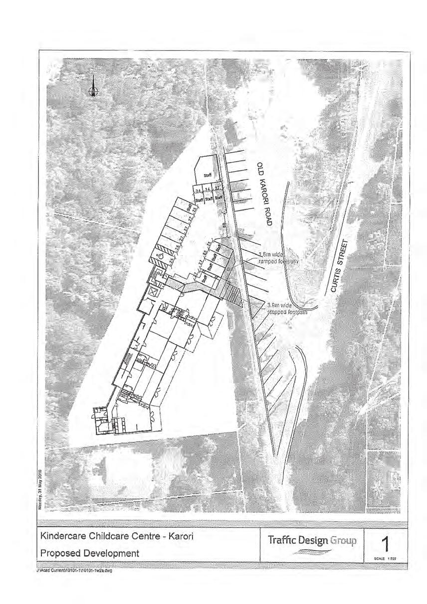
20 Transport Assessment for Curtis Street Plan Change Base Case Performance The base case represents the performance of the existing intersections with current traffic flows. Base models were built using the surveyed traffic flow data and calibrated against observed queue lengths. Detailed SIDRA outputs for the base case are shown in Appendix C. Analysis of the base case found that all three intersections currently perform relatively well with LOS of C or better generally being achieved. The following performance issues were identified: the Curtis Street approach to Chaytor Street shows a LOS of D in the Saturday model with an associated mean delay of 30 seconds. the Old Karori Road approach to the Karori Road / Chaytor Street intersection has a LOS of D with mean delays of 36 seconds. the signal controlled Chaytor Street right turn approach to the Karori Road / Chaytor Street intersection shows a LOS of D with delay of 46 seconds in the Saturday model and a LOS of E (57 second mean delay) in the weekday PM peak model. 6.3 Do Minimum Based on guidance from the New Zealand Transport Agency s (NZTA s) Integrated Transport Assessment Guidelines November 2010, assessment of the do minimum was undertaken for the 2017 forecast year (5 years in the future). Annual traffic growth of 2% was used to derive increased future traffic flows. This growth rate was taken from Table A25 from the NZTA s Economic Evaluation Manual January Traffic flows used for the do minimum assessments were also increased to reflect known / committed developments and to better reflect traffic conditions when sporting events occur in Ian Galloway Park. Weekday traffic projections include traffic generated by the Day Care Centre which has planning consent for land adjacent to the site and accessed from the Old Karori Road. The assumed trip generation, which was taken from the transport assessment supporting the resource consent application, is shown in Appendix D. Traffic surveys for this assessment were undertaken between the winter and summer sports seasons and therefore do not reflect conditions when the sports fields are being intensively used. Wellington City Council Officers provided count data undertaken during the start of the summer sports season (Saturday 3 December 2011). This was used to increase the flows recorded on Saturday 22 September Analysis of the intersection performance for the do minimum scenario showed similar performance to the base case. The analysis found only minimal degradation in intersection performance from the calibrated base models. The exceptions to this are: during the Saturday peak hour, the additional traffic associated with use of Ian Galloway Park results in LOS F and mean delays of 98 seconds for the Curtis Street approach to Chaytor Street. The base model showed LOS D with a mean delay of 30 seconds. poorer performance is also forecast for the Chaytor Street right turn and Old Karori Road approaches to the Karori / Chaytor / Old Karori Road signal controlled intersection. In the 5c October 2011 Opus International Consultants Ltd
21 Transport Assessment for Curtis Street Plan Change 17 Saturday do minimum scenarios, both approaches are forecast to operate at LOS E with delays of 69 and 57 seconds respectively. on the weekday PM peak, the Curtis Street approach to Chaytor Street is forecast to operate at LOS D with average delay of 35 seconds. The base model showed LOS C for this approach in the weekday PM peak. Summary of 2017 Do Minimum Scenario Overall, the three intersections modelled are forecast to perform acceptably for the 2017 do minimum scenario. Emerging issues are associated with the Curtis Street approach to Chaytor Street, particularly on Saturdays when Ian Galloway Park is used for sporting events. The movements at signal controlled intersection between Chaytor Street, Karori Road and Old Karori Road where poor levels of service are observed are minor movements and relatively lightly trafficked. Further detail is shown in Appendix E. 6.4 Development Scenarios The additional traffic associated with three possible land-uses has been modelled using the calibrated SIDRA models: Industrial, Bulk Retail; and / or Service Retail. Trips generated by each potential land use were assigned to the network as described in section 5.2. It was assumed that in each peak hour modelled, half the trips would be to the site and half would be away from the site. It is possible that any future proposals for use of the site would be a combination of activities. For this assessment, each land-use treated is separately as its own scenario. It was assumed as a starting point, that for each land-use scenario, the site would be developed to a GFA of 4000m². None of the service retail sites surveyed for the New Zealand Trips and Parking database were more than about 2700m² GFA. If service retail is provided at the site, it is likely to compliment another land-use such as bulk retail. The following sections summarise the findings of the traffic analysis for each potential land-use. The analysis is also summarised in Table 6.2 and Table 6.3. Curtis Street / Chaytor Street Analysis of the traffic effects of the three potential land-use scenarios on the Chaytor / Curtis Street intersection concluded that: the overall performance of the intersection is not significantly affected by development of the site; without mitigation, future development of the site will increase the average delay for motorists approaching Chaytor Street along Curtis Street; the additional average delay during the weekday PM peak hour, resulting from industrial use of the site is forecast to be approximately 10 seconds; 5c October 2011 Opus International Consultants Ltd
22 Transport Assessment for Curtis Street Plan Change 18 during the weekday PM peak hour, without mitigation, development of the site as bulk retail or service retail would increase delays for the Curtis Street approach from approximately 35 seconds to 103 and 192 seconds respectively (i.e. average delay of 1½ to 3 minutes per motorist); during the weekend peak hour, without mitigation, development of the site as bulk retail or service retail is forecast to increase delays for the Curtis Street approach from approximately 97 seconds (1 ½ minutes) to 306 and 678 seconds respectively (i.e. average delay of 5 to 10 minutes per motorist); and the effect on traffic using other approaches to the intersection is forecast to be negligible. Most motorists would be unwilling to wait for 678 seconds (5 to 10 minutes) to turn into an intersection. Without mitigation, it is likely that they would either re-route to avoid the delays or accept unsafe gaps in the conflicting traffic movements. Without mitigation, motorists travelling towards Kelburn or Wellington CBD may reroute via local roads such as Randwick Road or Creswick Terrace. The route between the site and Upland Road is approximately equal in length. The width of Randwick Road means that of the two routes, travel via Randwick Road would be faster and therefore more appealing. The delays on the Curtis Street approach to Chaytor Street would need to be mitigated. Mitigation would reduce the likelihood of additional crashes at the intersection and minimise traffic rerouting through residential streets. Alternatively the size of the bulk or service retail could be limited to avoid these effects. Sections 6.5 and 6.6 outline the scope for mitigating this effect and for development thresholds respectively. Curtis Street / Whitehead Road Analysis of the traffic effects of the three development scenarios on the Curtis / Whitehead Road intersection concluded that: the overall performance of the intersection is not affected by development of the site for Industrial or Bulk Retail purposes during the weekday PM or weekend peak; significant average delays of more than 5 minutes (LOS F) are forecast for the Whitehead approach to Curtis Street under Service Retail scenario for the weekend peak hour; and although bulk retail use of the site would increase average delays for motorists approaching Curtis Street on Whitehead Road by approximately 10 seconds, the approach would continue to perform with an acceptable LOS C. Karori Road / Chaytor Street Analysis of the traffic effects of the three development scenarios on the Curtis / Whitehead Road intersection (see Appendix F) concluded that: the overall performance of the intersection is not significantly affected by development of the site for Industrial or Bulk Retail purposes during the weekday PM or weekend peak; and average delays during the weekend peak hour for the movement from Karori Road to Chaytor Street are forecast to increase from approximately 13 seconds per motorists (LOS B) to just under 50 seconds (LOS D) as a result of service retail use of the site. 5c October 2011 Opus International Consultants Ltd
23 Transport Assessment for Curtis Street Plan Change 19 Table 6.2 Intersection Performance: Saturday Peak Hour Chaytor / Curtis Saturday Peak Do Min Industrial Bulk Retail Serviced Retail Approach Lane Average Delay LOS Average Delay LOS Average Delay LOS Average Delay LOS Chaytor Street (South) Through 0.0 A A 0.0 A Right Turn 11.3 B B 14.8 B Curtis Left and Right 97.5 F F F Chaytor Street (North) Through and Right 0.2 A A 1.0 A Curtis / Whitehead Saturday Peak Do Min Industrial Bulk Retail Serviced Retail Approach Lane Average Delay LOS Average Delay LOS Average Delay LOS Average Delay LOS Curtis Street (East) Through 5.0 A A 4.9 A Right 9.4 A B 17.4 C Whitehead Road Left and Right 10.0 B C F Curtis Street (West) Through and Left 5.0 A A 5.3 A Karori / Chaytor / Old Karori Saturday Peak Do Min Industrial Bulk Retail Serviced Retail Approach Lane Average Delay LOS Average Delay LOS Average Delay LOS Average Delay LOS Chaytor Street Left 9.2 A A 11.6 B Right 69.2 E E 69.2 E Old Karori Road Through and Left 57.2 E E 85.6 F Karori Road Through 10.4 B B 12.2 B Right 13.1 B B 47.7 D 5c October 2011 Opus International Consultants Ltd
24 Transport Assessment for Curtis Street Plan Change 20 Table 6.3 Intersection Performance: Weekday PM Peak Hour Chaytor / Curtis Weekday PM Do Min Industrial Bulk Retail Serviced Retail Approach Lane Average Delay LOS Average Delay LOS Average Delay LOS Average Delay LOS Chaytor Street (South) Through 0.0 A 0.0 A 0.0 A 0.0 A Right Turn 9.1 A 9.1 A 9.3 A 9.5 A Curtis Street Left and Right 34.7 D 45.5 E F F Chaytor Street (North) Through and Right 0.2 A 0.3 A 0.6 A 0.8 A Curtis / Whitehead Weekday PM Do Min Industrial Bulk Retail Serviced Retail Approach Lane Average Delay LOS Average Delay LOS Average Delay LOS Average Delay LOS Curtis Street (East) Through 4.9 A 4.9 A 4.9 A 4.9 A Right 8.7 A 9.0 A 9.5 A 10.2 B Whitehead Road Left and Right 8.3 A 8.7 A 10.2 B 12.5 B Curtis Street (West) Through and Left 5.2 A 5.2 A 5.3 A 5.3 A Karori / Chaytor / Old Karori Weekday PM Do Min Industrial Bulk Retail Serviced Retail Approach Lane Average Delay LOS Average Delay LOS Average Delay LOS Average Delay LOS Chaytor Street Left 10.2 B 10.7 B 12.5 B 14.8 B Right 65.4 E 68.2 E 68.2 E 68.2 E Old Karori Road Through and Left 54.3 D 55.1 E 56.6 E 58.7 E Karori Road Through 10.5 B 10.9 B 11.3 B 11.8 B Right 10.7 B 11.8 B 12.2 B 12.6 B 5c October 2011 Opus International Consultants Ltd
25 Transport Assessment for Curtis Street Plan Change 21 Summary of Development Scenario Intersection Performance The preceding sections (and tables below) show that development of the site for industrial purposes would not generate sufficient traffic to significantly affect the traffic efficiency of surrounding intersections. Development of the site for bulk retail purposes is likely to exacerbate existing delays on the Curtis Street approach to Chaytor Street. This effect would be evident during the weekday PM peak and particularly during the Saturday peak hours. Measures to mitigate these effects would be necessary. The following section (6.5) presents the scope for possible mitigation measures. The traffic effects associated with potential development of the site as GFA 4000m² bulk or service retail are significant and would be difficult, if not impossible to sufficiently mitigate. Other ways to minimise the effect of this land-use would be to limit the size of the development. Possible thresholds, beyond which detailed consideration of the traffic and transportation effects would be required are presented in section Scope for Mitigation of Traffic Effects A series of tests were undertaken to determine the potential for mitigating the traffic effects associated with each potential land-use. Engineering investigation and design would be needed to determine the feasibility and cost of these measures. It would be appropriate to determine the feasibility of these options as part of a transport assessment submitted in support of a specific development proposal. The effect of the development scenarios could be mitigated in the following ways: limit the size of development; and / or minor intersection upgrades allowing for additional approach lanes. The effect of additional approach lanes was modelled for both the bulk retail and service retail development scenarios for the Curtis Street / Whitehead Road intersection and the Curtis Street / Chaytor Street intersection. Figure 6-1 and Figure 6-2 show the existing intersection arrangement (on the left) and the test arrangements (on the right). Figure 6-1 Curtis / Whitehead Intersection Mitigation Measures 5c October 2011 Opus International Consultants Ltd
26 Transport Assessment for Curtis Street Plan Change 22 Figure 6-2 Curtis / Chaytor Intersection Mitigation Measures The changes shown above have been modelled for the Saturday Peak hour only as this was the worst performing time period for each development type. For the service retail test, the development size was also reduced to 3000m². The bulk retail development mitigation test found the following: delay on the Curtis Street approach to Chaytor Street reduced from seconds (without mitigation) to 67.9 seconds for the right turn and 92.2 seconds for the left turn with mitigation. (The delay for this approach was approximately 35 seconds for the 2017 weekend do minimum.) delay on the Whitehead Road approach to Curtis Street reduced slightly from 20.3 seconds to 18.2 for the right turn lane and 19.3 seconds for the left turn lane. The service retail development mitigation test (including intersection changes and reduced development area) found the following: delay on the Curtis Street approach to Chaytor Street reduced from seconds to seconds for the right turn and seconds for the left turn. (The delay for this approach was approximately 35 seconds for the 2017 weekend do minimum.) delay on the Whitehead Road approach to Curtis / Whitehead intersection reduced from seconds to 94.8 for the right turn lane and 33.2 seconds for the left turn lane. Minor delay reduction across all other approaches. These tests show that it is possible to mitigate the traffic effects of potential bulk retail land-use by introducing changes to nearby intersections. The tests also show that to minimise effects of serviced retail it would be necessary to limit the size of permitted development below the 4000m² threshold currently proposed. 5c October 2011 Opus International Consultants Ltd
27 Transport Assessment for Curtis Street Plan Change Summary of Traffic Assessment and Potential Development Thresholds This chapter has shown that: the intersection between Curtis Street and Chaytor Street is the most sensitive to additional traffic; nearby intersections have less capacity to accommodate additional traffic on weekends than they do in the weekday evening peak hour; the additional traffic associated with GFA 4000m² industrial land-use at the site could be accommodated without affecting the efficient operation of nearby intersections; the traffic effects associated with GFA 4000m² bulk or service retail activities would need to be mitigated. Potential Development Thresholds Development thresholds could be based on the traffic capacity of nearby intersections. The Chaytor Street / Curtis Street intersection is most sensitive to additional traffic. It is therefore appropriate that the performance of this intersection is used to determine potential development thresholds based on traffic efficiency. On the basis of the trip rates presented in section 5.1 and the traffic distribution presented in section 5.2, we have determined that approximately 100 additional trips can be generated by the site before the performance of the Curtis Street approach to Chaytor Street begins to deteriorate. Table 6.4 shows possible GFA thresholds for alternative activities at the site. Beyond these thresholds, mitigation for traffic effects is likely to be necessary. The numbers in brackets that would be applied on the basis of weekend travel demand. Potential Land-Use Trips per 100m² Potential GFA Threshold PM Peak (Weekend Peak) Industrial m² Bulk Retail 5.56 (7.85) 1700 m² (1200 m²) Service Retail 9.68 (20.62) 1000 m² (500 m²) Table 6.4 Potential GFA Thresholds By way of comparison, the mean trip generation rate for offices on a weekday peak hour would be 1.71 trips per 100 m² GFA. This is similar to the industrial trip generation rate and would lead to a development threshold of 5800 m². Activities such as retail or offices often require provision of significant areas of off-street parking. Development thresholds based on other site attributes such as parking supply may therefore be more appropriate for this site. This is discussed in the following chapter. 5c October 2011 Opus International Consultants Ltd
28 Transport Assessment for Curtis Street Plan Change Parking Narrow lane widths and limited forward visibility mean there is minimal space for on-street parking on Curtis Street. In many parts of Curtis Street, the poor forward visibility and narrow road widths mean that on-street parking would be unsafe. Although wider, Whitehead Road has limited width, relatively low forward visibility and would not be suitable for on-street parking. This means that it would be to avoid negative effects it will be important for parking associated with the development to be safely accommodated. This could be through the provision of adequate offstreet parking within the development site. The southern leg of Old Karori Road provides opportunities for accommodating some on-street parking, particularly during the weekend when the day care is not in use. 7.1 Off-Street Parking Unless otherwise specified, Wellington City Council s District Plan defines any activity providing more than 70 parking spaces as a high traffic generator and requires a Transport Assessment to be prepared as part of a resource consent application. This chapter examines whether this threshold is appropriate for the proposed rezoning of Curtis Street. The 2011 New Zealand Trips and Parking Database was used as the basis for estimating parking demand and appropriate parking provision associated with the potential land-use scenarios defined in section 5.1. Industrial The Industrial sites listed in the database have an average GFA of 4245m 2. On average 64 car parking off-street spaces were provided. The mean maximum parking demand listed in the database was 39 vehicles or 62% occupancy. This type of land use would not typically have a high turn-over of parking spaces. Most of the parking spaces would be used by staff, with some allocated for visitors to the site. This land-use is least likely to result in overspill parking on-street. On the basis of the average GFA, it would be necessary to provide one parking space per 100m 2 GFA in order to accommodate the mean maximum parking demand [=100 x (39 / 4245)]. Bulk Retail No car parking data was available for the sites used to assess the weekday trip rates for bulk retail land use. Two of the three sites used for the weekend trip rates did however have parking data. These two sites have an average GFA of 3,162m 2 and provide 65 car parking spaces. The mean maximum occupancy recorded at these sites was 62 vehicles or 95%. This type of land use is likely to generate a higher demand for parking on weekends when it attracts a higher number of customers. On the basis of the average GFA, it would be necessary to provide two parking spaces per 100m 2 GFA in order to accommodate the mean maximum parking demand [=100 x (62 / 3162)]. Service Retail For site surveyed during the week, the number of parking spaces provided for retail activities ranged from 12 to 226, with an average of 77 spaces. Most of the surveyed sites were significantly 5c October 2011 Opus International Consultants Ltd
29 Transport Assessment for Curtis Street Plan Change 25 smaller than the land available at Curtis Street with GFA of between 50 and 2000m 2. On average 13 spaces per 100m 2 GFA was provided which is the equivalent of 520 off-street car parks for a 4000m 2 site. Weekday peak demand for a 4000m 2 service retail site would be in the order of 280 car parks. Weekend demand was surveyed as 5.5 car parks per 100m 2 GFA which is the equivalent of 220 car parks for a 4000m 2. Provision of 70 off-street car parks or fewer would therefore hardly be unable to accommodate the expected peak demand associated with the site. Large service retail developments with this number of off-street car parks would therefore result in significant levels of on-street car parking and a serious safety hazard. A service retail development designed to accommodate peak parking demand of 5.5 spaces per 100m 2 GFA would therefore either provide 220 car parks (i.e. within a multi-story car park) or limit development size. 7.2 Summary of Parking Assessment & Possible Thresholds This assessment has found that the surrounding road network has little or no ability to safely accommodate on-street parking associated with development of the site. For this location it is important that most, if not all of the parking demand associated with land-use is accommodated within the site. It is expected that the site can be easily developed for Industrial and Bulk Retail activities without requiring more car parks that the 70 space threshold currently defined in the District Plan. Demand associated with these activities should also be relatively easy to accommodate within the site. Service Retail activities require attract a significantly greater level of parking demand which would be more difficult to accommodate within the site. Potential Development Thresholds For Curtis Street, minimum parking provisions are more appropriate than using the number of car parks as a maximum threshold. Table 7.1 presents the forecast mean maximum parking demand associated with each of the potential land-use activities. It also shows the land area required to accommodate the estimated parking demand (assumes 21m 2 per car park include. aisles). The possible GFA thresholds are derived by assuming that the total land area, including development and parking, does not exceed 6000 m 2. Land-use Potential GFA Threshold (sq.m) Mean Max. Demand (Per 100sq.m) Forecast Mean Max. Demand (Spaces) Parking Land Area (sq.m) Total Land Area (sq.m) Industrial Bulk Retail Service Retail Office Table 7.1 Potential Thresholds Based on Parking Provision If parking effects are to be avoided, developments with the GFA shown in the table need to provide, as a minimum, the mean maximum number of parking spaces. However developments that provide more than the minimum parking requirement may still result in adverse traffic effects. It 5c October 2011 Opus International Consultants Ltd
30 Transport Assessment for Curtis Street Plan Change 26 is therefore appropriate to use the GFA as a threshold and to choose the lower of the values presented in Table 7.1 and Table 6.4, above. 5c October 2011 Opus International Consultants Ltd
31 Transport Assessment for Curtis Street Plan Change Servicing and Access Servicing and access has been considered from the point of view of the surrounding road network. Internal servicing and access is too dependent on the specific developer proposals to assess at a theoretical or high level. The topography of the site is likely to limit the locations where new site access would be provided. Figure 7.1 (at the end of this report) shows the gradient of land adjacent to and perpendicular to the site boundary. It provides an indication of where developers are most likely to propose new site access. It shows that gradients of less than 10% (indicated with a green line) are available at three locations along the site boundary: from the southern leg of the Old Karori Road; from Whitehead Road, west of its intersection with Curtis Street; and from Curtis Street, south of its intersection with Whitehead Road. The Old Karori Road (no exit street) and Whitehead Road have relatively low traffic flows and would be more suitable for new site access. Consideration should also be given to the types of vehicles that would service the site. The District Plan requires consideration of an 8 ton rigid axle truck (i.e. no articulation). Industrial or bulk retail activities at the site is however likely to generate deliveries using articulated semi-trailer vehicles more than 17m in length. 8.1 Tracked Path Analysis The ability for articulated semi-trailer vehicles to manoeuvre through the existing intersections was assessed using AutoTURN software. That analysis concluded that: semi-trailer vehicles could be accommodated at the Curtis Street / Chaytor Street without conflicting with any opposing traffic movements; the right turn from Chaytor Street to and Old Karori Road and the left turn for the reverse movement cannot be made by semi-trailer vehicles; semi-trailer vehicles could not safely turn left turn out from or right-into the southern leg of Old Karori Road. This would limit movements to / from Old Karori Road and the southern leg of Curtis Street; Figure 7.2 shows the tracked paths for the 17m semi-trailer vehicles turning from Curtis Street to Whitehead Road. Figure 7.3 shows the tracked paths for turns from Whitehead Road. The figures show that each of these turning movements could result in conflict with opposing traffic movements. The topography adjacent to the intersection means that improvements could be made to avoid this problem. Easing the southern side of Whitehead Road would be relatively easy. The engineering plant located immediately north of Whitehead Road is likely to increase the costs associated with easing this side of the intersection. This means that it would be more difficult (costly) to mitigate the effects of semi-trailers turning between Whitehead Road and the arm of Curtis Street north of the intersection. It is however possible to reasonably mitigate these effects. Changes to this intersection should also address the poor visibility to and from Curtis Street, north of the intersection. 5c October 2011 Opus International Consultants Ltd


32 OLD KARORI ROAD WHITEHEAD ROAD CURTIS STREET KEY - SITE ACCESS GRADES A1 A3 ACCESS LOCATION WITH GRADE LESS THAN 10% ACCESS LOCATION WITH GRADES 10% TO 20% ACCESS LOCATION EXCEEDS 20% GRADE ACCESS RESTRICTED DUE TO PROXIMITY TO EXISTING JUNCTION m CURTIS STREET PLAN CHANGE FIGURE ACCESS CONSTRAINTS MAP SCALE 1:1,000 (A3)
33 SEMI-TRAILER WHITEHEAD ROAD NEW ZEALAND (NZ) SEMI-TRAILER NEW ZEALAND (NZ) SEMI-TRAILER NEW ZEALAND (NZ) CURTIS STREET SEMI-TRAILER NEW ZEALAND (NZ) NEW ZEALAND (NZ) SEMI-TRAILER NEW ZEALAND (NZ) SEMI-TRAILER SEMI-TRAILER NEW ZEALAND (NZ) CURTIS STREET TO WHITEHEAD ROAD SEMI-TRAILER TRACKING PATHS FIGURE 7.2 SCALE 1:400 (A3)
 SEMI-TRAILER NEW ZEALAND (NZ) SEMI-TRAILE NEW ZEALAND WHITEHEAD ROAD TO CURTIS STREET SEMI-TRAILER TRACKING PATHS FIGURE 7.")
34 SEMI-TRAILER NEW ZEALAND (NZ) NEW ZEALAND (NZ) SEMI-TRAILER SEMI-TRAILER NEW ZEALAND (NZ) SEMI-TRAILER NEW ZEALAND (NZ) WHITEHEAD ROAD SEMI-TRAILER NEW ZEALAND (NZ) CURTIS STREET SEMI-TRAILER NEW ZEALAND (NZ) SEMI-TRAILER NEW ZEALAND (NZ) SEMI-TRAILE NEW ZEALAND WHITEHEAD ROAD TO CURTIS STREET SEMI-TRAILER TRACKING PATHS FIGURE 7.3 SCALE 1:400 (A3)
35 Transport Assessment for Curtis Street Plan Change Road Safety Effects Section 2.6 concluded that there was a trend for road traffic crashes involving turning vehicles at the intersection between Curtis Street and Chaytor Street. Section 6.4 showed that the increase in traffic associated with 4000m2 bulk or service retail would, if no mitigation measures are introduced result in significant delays for motorists approaching Chaytor Street on Curtis Street. If un-mitigated, the additional delay, particularly during the weekends peak period is likely to encourage risk-taking which could increase the numbers of crashes at the intersection. It is therefore important from both a traffic efficiency and road safety perspective that mitigation measures are introduced to minimise the delays for motorists on this approach to the intersection. Developments that are smaller than the thresholds presented in section 6.6 would not require mitigation. It is also important that parking demand associated with the development site is accommodated to avoid on-street parking on surrounding streets. On-street parking would create potential safety hazards for other road users. On-street parking problems are most likely to be associated with service retail land-use. The previous chapter has shown that some of the vehicles likely to be associated with Industrial or Bulk Retail land-uses would not be able to safely negotiate the surrounding road network without changes to intersections. The intersection between Whitehead Road and Curtis Street is most likely to need changes to accommodate a semi-trailer vehicle. This would however be dependent on the location chosen for new site access. 5c October 2011 Opus International Consultants Ltd
36 Transport Assessment for Curtis Street Plan Change Conclusions and Recommendations The assessment documented in this report has concluded that effects associated with developing the site for industrial or bulk retail activities can be adequately mitigated through changes to the surrounding infrastructure. The mitigation likely to be required should: ensure vehicles needed to service the development can safely manoeuvre through nearby access (e.g. Curtis Street / Whitehead Road intersection and Curtis Street / Old Karori Road intersection); mitigate delays at the Curtis Street / Chaytor Street intersection resulting from the development; and avoid the incidence of on-street parking associated with the development site. This assessment has also found that it would not be possible to adequately mitigate the traffic effects associated with developing the site for 4000m 2 of service retail. The intersection delays associated with a service retail development of this size could not be appropriately mitigated without significant changes to nearby intersections which would result in additional environmental effects. The parking demand associated with service retail would also be difficult to safely manage. It is recommended that the amount of land developed as service retail is limited such that it is ancillary to other activities at the site Recommended Development Thresholds To allow the Wellington City Council to control development of land at Curtis Street and to understand the transport effects of potential development, it recommended that development thresholds are identified. Proposed developments that exceed these thresholds should be supported by a detailed and robust transportation assessment specific to the proposal. The two main issues this assessment has identified are: the effects of additional traffic on the safe and efficient operation of the Curtis Street / Chaytor Street intersection; and the potential for on-street parking to cause a safety hazard to users of streets surrounding Curtis Street. Thresholds related to traffic generation or parking are therefore appropriate. Potential GFA thresholds were presented in sections 6.6 and 7.2. It is recommended that the lower of these is applied for each potential land-use. Potential Land-Use Potential Traffic Generation GFA Threshold (sq.m) Potential Parking Demand GFA Threshold (sq.m) Recommended GFA Threshold (sq.m) Industrial 5700 m² 4900 m² 4900 m² Bulk Retail 1700 m² (1200 m²) 4100 m² 1500 m² Service Retail 1000 m² (500 m²) 2700 m² 500 m² Office 5800 m² 3600 m² 3600 m² 5c October 2011 Opus International Consultants Ltd
37 Transport Assessment for Curtis Street Plan Change 30 5c October 2011 Opus International Consultants Ltd
38 APPENDIX A: Crash History
39 N KEY Fatal Dark Wet Icy Peds Cyclist Km 0.6Km
40 Plain English report, run on 11-Jul-2012 Page 1 First Street D Second street I or landmark Distance R Crash Number Date Day Time Description of Events Crash Factors DD/MM/YYYY DDD HHMM (ENV = Environmental factors) Road Natural Light Weather Junction Cntrl Tot Inj F S M A E I T R N CHAYTOR ST CHAYTOR ST CHAYTOR ST CHAYTOR ST CHAYTOR ST CHAYTOR ST CHAYTOR ST CHAYTOR ST CHAYTOR ST CHAYTOR ST CURTIS ST CURTIS ST CURTIS ST WHITEHEAD ROAD 20S CURTIS ST 20W CURTIS ST I CURTIS ST I CURTIS ST I CURTIS ST I CURTIS ST I CURTIS ST I CURTIS ST I CURTIS ST I CURTIS ST 30N CHAYTOR ST 250N CHAYTOR ST 50W CHAYTOR ST 20E CURTIS ST /07/2009 Fri 1450 CAR1 NBD on CHAYTOR ST hit rear end CAR1 following too closely Dry Overcast Fine T Type of CAR2 stop/slow for cross traffic Junction /02/2007 Mon 0824 CAR1 EBD on CHAYTOR ST changing CAR1 didnt see/look behind when Dry Overcast Fine T Type Nil 1 lanes to left hit CYCLIST2 (Age 57) changing lanes, position or Junction direction /08/2008 Fri 0745 MOPED2 turning right hit by CAR1 overtaking on left Wet Bright Fine T Type Give 1 oncoming CAR1 EBD on CHAYTOR ST Junction Way Sign /06/2008 Thu 1650 CAR1 EBD on CHAYTOR ST hit rear end CAR1 following too closely Wet Twilight Mist T Type of CAR2 stop/slow for queue Junction /10/2008 Wed 1855 CAR1 EBD on CHAYTOR ST hit CAR2 turning right onto CHAYTOR ST from the left, CAR1 hit Cliff Bank CAR2 failed to give way at give way sign, didnt see/look when required to give way to traffic from another direction Dry Bright Fine T Type Junction /02/2009 Wed 1810 BUS1 EBD on CHAYTOR ST sideswiped VAN2 didnt see/look behind when Wet Overcast by VAN2 turning left changing lanes, position or direction Light Rain T Type Junction /12/2007 Sun 1900 CAR1 SBD on CURTIS ST lost control CAR1 suddenly turned left, new Dry Bright Fine T Type turning left, CAR1 hit Cliff Bank driver showed inexperience, Junction interferred with driver /03/2007 Fri 0800 CAR2 turning right hit by oncoming CAR1 EBD on CHAYTOR ST CAR1 overtaking on left, in bus/transit lane CAR2 failed to give way when turning to nonturning traffic, didnt see/look when visibility obstructed by other vehicles Dry Overcast Fine T Type Junction /11/2008 Thu 0750 VAN2 turning right hit by oncoming CAR1 EBD on CHAYTOR ST CAR1 in bus/transit lane, didnt see/look when visibility obstructed by other vehicles VAN2 failed to give way when turning to nonturning traffic Dry Bright Fine T Type Junction /07/2009 Wed 0800 CAR2 turning right hit by oncoming CAR1 EBD on CHAYTOR ST CAR1 in bus/transit lane CAR2 failed to give way when turning to non-turning traffic, didnt see/look when visibility obstructed by other vehicles Dry Overcast Fine T Type Junction /07/2009 Fri 1030 TRUCK1 NBD on CURTIS ST hit parked TRUCK1 too far left/right Dry Bright Fine Unknown Nil veh, TRUCK1 hit Parked Vehicle /08/2009 Fri 1908 CAR1 NBD on CURTIS ST lost control turning right, CAR1 hit Kerb on right hand bend CAR1 lost control avoiding another vehicle CAR2 did not see or look for other party until too late ENV: visibility limited by curve, entering or leaving private house / farm Dry Dark Fine Driveway Nil /07/2010 Tue 1515 CAR2 turning right hit by oncoming MOPED1 WBD on CURTIS ST CAR2 failed to give way when turning to non-turning traffic, attention diverted by driver dazzled by sun/lights, didnt see/look when required to give way to traffic from another direction ENV: dazzling sun, entering or leaving private house / farm Dry Bright Fine Driveway Nil /08/2011 Mon 1535 MOPED1 WBD on WHITEHEAD ROAD lost MOPED1 lost control when turning, Dry Overcast Fine T Type Give 1 control on curve and hit VAN2 head misjudged speed of own vehicle, new Junction Way on driver showed inexperience Sign Give Way Sign Give Way Sign Give Way Sign Give Way Sign Give Way Sign Give Way Sign Give Way Sign Give Way Sign
41 CRASH LIST DETAIL REPORT Run on: 11 Jul 2012 Crash List: JTP Curtis Street (14 crashes) Total Injury Crashes: Total Non-Injury Crashes: Crash Type Number % Crash factors (*) Number % Overtaking Crashes: Straight Road Lost Control/Head On: Bend - Lost Control/Head On: Rear End/Obstruction: Crossing/Turning: Pedestrian Crashes: Miscellaneous Crashes: TOTAL: % Failed Giveway/Stop Overtaking Incorrect Lane/posn Poor handling Poor Observation Poor judgement Road factors Weather Other Location Local road % St.Highway % Total % Urban Open road TOTAL: % Intersection/Midblock Number % Intersection: MidBlock: TOTAL: Crashes with a: % Driver factor % Environmental factor 2 14% (*) factors are counted once against a crash - ie two fatigued drivers count as one fatigue crash factor. Note: Driver/vehicle factors are not available for non-injury crashes for Northland, Auckland, Waikato and Bay of Plenty before This will influence numbers and percentages. Crashes with objects(s) struck 4 29% Object Struck Number % TOTAL: % Environmental Factors Number % Cliff Bank Kerb Parked Vehicle Light/Overcast Crashes: Dark/Twilight Crashes: TOTAL: % TOTAL: 4 28% Crash Numbers Year Fatal Serious Minor Non-Inj Wet/Ice: Dry: TOTAL: % Day/Period Weekday Weekend TOTAL: Number % % TOTAL: Vehicles Number % Car Van/Ute Truck Bus Motorcycle Bicycle TOTAL: % Note: Percentages represent the % of crashes in which the vehicle, cause or object appears.
42 APPENDIX B: Trip Generation
43 Industrial Trip Generation Site No. 575 Source of Data Canterbury University Territorial Local Authority Christchur ch 13 ATLA Study Manukau Suburb or Locality Middleto n East Tamaki Activity Name 9 Craft Place Industry Springs Road Industrial Units Land Use Group Industry Land Use Activity (Primary) Manufact uring & Suburban 14/09/2007 Commerci al Manufact uring Location Environm ent Date of Survey Time of Survey 14:20-16:50 Outer Suburban 26/03/ Day of Survey GFA (m 2 ) Parking Spaces Provided On-site MAX ON-SITE PARKING DEMAND TRIP GENERATION RATES GFA (IN+OUT) AM PM DAILY Friday Friday ATLA Study Manukau Wiri South Auckland Mail Centre Industry Storage Outer Suburban 24/06/ Wednesd ay Canterbury University Christchur ch Middleto n Hands Road - Stratco Lrd Industry Contracto r Suburban 17/09/ :30-16:30 Monday DCS Ltd Average Canterbury University Traffic Design Group Christchur Sockburn EasyStore Industry Storage 28/01/2005 ch Christchur Middleto 107 Magadala Place Industry Storage Suburban 20/09/2007 ch n Auckland Penrose MG Marketing Distribution Centre Industry Storage 8:00-17:30 14:30-17:30 Outer Suburban 20/09/ :00-18:00 Friday Thursday Thursday 6,
44 Bulk Retail Trip Generation Site No. Territorial Local Authority Suburb or Locality Activity Name Land Use Group Land Use Activity (Primary) Date of Survey Time of Survey Day of Survey GFA (m 2 ) Parking Spaces Provided On-site SURVEYED ARRIVAL/DEPARTUR E FLOW MAX ON-SITE PM Peak (vph) PARKING DEMAND TRIP GENERATION RATES GFA (IN+OUT) (vph or vpd/100m2 GFA) at time AM PM DAILY 530 North Shore Wairau Harvey Norman Retail Bulk 31/07/ :00-18:00 Tuesday :30-17: Christchurch Hornby The Warehouse / Briscoes Bulk Retail Centre Retail Bulk 8/05/ :00-17:30 Monday :00-17: North Shore Wairau Harvey Norman Retail Bulk 1/08/ :00-18:01 Wednesd ay :30-17: Average Waitakere Henderson South The Warehouse Ltd Retail Bulk 24/07/ Saturday Christchurch Upper Riccarton Miller's Homeworld Retail Shop 24/01/ :00-16:00 Saturday Auckland Onehunga Grove Mitre 10 Retail Shop 27/03/1993 Average Saturday
45 Service Retail Trip Generation Site No. Territorial Local Authority Land Use Land Use Activity (Primary) Parking Spaces Provided MAX ON-SITE PARKING TRIP GENERATION GFA (IN+OUT) Activity Name Date of Survey Time of Survey Day of Survey GFA (m 2 ) On-site DEMAND AM PM DAILY 66 Christchurch Cashmere Club, Colombo St Retail Bar 19/11/ Friday Christchurch Bros Kelly's, Centaurus Road shops Retail Bar 14/12/ Thu Christchurch Cashmere Club, Colombo St Retail Bar 17/11/ Thursday Christchurch Parklands Tavern Retail Bar 15/07/ Thursday Christchurch Ferrymead Tavern Retail Bar 15/07/ Thursday Marlborough Redwood Tavern Retail Bar 23/02/ Thursday North Shore Glenfield Tavern Retail Bar 28/09/ Wednesday North Shore Glenfield Tavern Retail Bar 28/09/ Wednesday Christchurch Subway Retail Fast Food 30/05/ :30-13:30 Friday Waitakere Pumpkin Patch Retail Other 6/10/ :00-15:00 Friday North Shore Sizzlers Wairau Park Retail Restaurant 14/05/ Friday North Shore Sizzlers Wairau Park Retail Restaurant 26/05/ Friday North Shore Pizza Hutt Retail Restaurant 18/06/ Friday Waitakere Valentines and The Boats Inn Retail Restaurant 22/10/ Friday Auckland Richardsons Tavern Retail Restaurant 10/12/ Friday Auckland Ellerslie Oaks Retail Restaurant 4/02/ Friday Manukau Metro Bar and Grill Retail Restaurant 28/01/ Friday Auckland Liquor King Retail Shop 7/01/ Friday Christchurch Liquor King Retail Shop 13/05/ :00-18:00 Friday Tauranga Video & Barber shop Retail shop 30/06/ :00-22:00 Friday Tauranga Civic Video and a barber Retail Shop 26/6/2006-2/7/ :00-22:00 Monday-Sunday Hamilton Total Furnature Retail Shop 16/12/ :00-12:00 2:00-3:00 Thursday Rodney Benchmark Building Supplies Retail Shop 29/04/ Thursday Manukau Benchmark Retail Shop 15/04/ Thursday North Shore Grove Mitre 10 Retail Shop 25/03/ Thursday North Shore Payless Plastics Retail Shop 22/04/ Thursday Hamilton Stacks Retail Shop 4/08/2004 8:00-9:00 12:00-15:00 Wednesday :00-17: Hamilton Unknown Retail Shop 4/08/2004 8:00-9:00 12:00-15:00 16:00-17:00 Wednesday Manukau The New Hub Furniture Shop Retail Shop 15/06/ Average
46 Service Retail Trip Generation 76 Christchurch Parklands Tavern Retail Bar 17/07/ Saturday Christchurch Ferrymead Tavern Retail Bar 17/07/ Saturday Auckland Duke of Wellington Retail Bar 9/10/ Saturday North Shore Georgie Pie Retail Fast Food 4/12/ Saturday Rodney KFC Orewa Retail Fast Food 20/11/ Saturday Auckland McDonalds Retail Fast Food 20/11/ Saturday North Shore KFC Takapuna Retail Fast Food 25/06/ Sunday Waitakere Pumpkin Patch Retail Other 7/10/ :00-15:00 Saturday Rodney Honey Café & Store Retail Other 3/09/ :00-13:00 Saturday North Shore Sizzlers Wairau Park Retail Restaurant 15/05/ Saturday North Shore Sizzlers Wairau Park Retail Restaurant 27/05/ , Saturday North Shore United Video, Mokoia Road Retail Shop 2/07/ , Saturday Christchurch Miller's Homeworld Retail Shop 24/01/ :00-16:00 Saturday Auckland Grove Mitre 10 Retail Shop 27/03/ Saturday Auckland Danske Mobler Furniture Retail Shop 15/06/ Saturday Tauranga Video & Barber shop Retail shop 1/07/ :00-22:00 Saturday Average
47 APPENDIX C: Base SIDRA Models
48 LANE SUMMARY Chaytor / Curtis Giveway / Yield (Two-Way) Site: Chaytor / Curtis Lane Use and Performance Demand Flows Deg. Lane Average Level of 95% Back of Queue Lane SL Cap. Prob. L T R Total HV Cap. Satn Util. Delay Service Vehicles Distance Length Type Adj. Block. veh/h veh/h veh/h veh/h % veh/h v/c % sec veh m m % % South: Chaytor (South) Lane LOS A Lane LOS A Turn Bay Approach NA East: Curtis Lane LOS C Approach LOS C North: Chaytor (North) Lane LOS A Approach NA Intersection NA Level of Service (LOS) Method: Delay (HCM 2000). Lane LOS values are based on average delay per lane. Minor Road Approach LOS values are based on average delay for all lanes. NA: Intersection LOS and Major Road Approach LOS values are Not Applicable for two-way sign control since the average delay is not a good LOS measure due to zero delays associated with major road lanes. SIDRA Standard Delay Model used. Processed: Wednesday, 24 October 20121:23:49 p.m. Copyright Akcelik and Associates Pty Ltd SIDRA INTERSECTION Project: G:\LocalAuthorities\Wellington City\Proj\5-C Curtis Street Plan Change\700 Physical Works\6 Base Model\Tuesday Models.sip , OPUS INTERNATIONAL CONSULTANTS, FLOATING
49 LANE SUMMARY Chaytor / Curtis Giveway / Yield (Two-Way) Site: Chaytor / Curtis Lane Use and Performance Demand Flows Deg. Lane Average Level of 95% Back of Queue Lane SL Cap. Prob. L T R Total HV Cap. Satn Util. Delay Service Vehicles Distance Length Type Adj. Block. veh/h veh/h veh/h veh/h % veh/h v/c % sec veh m m % % South: Chaytor (South) Lane LOS A Lane LOS B Turn Bay Approach NA East: Curtis Lane LOS D Approach LOS D North: Chaytor (North) Lane LOS A Approach NA Intersection NA Level of Service (LOS) Method: Delay (HCM 2000). Lane LOS values are based on average delay per lane. Minor Road Approach LOS values are based on average delay for all lanes. NA: Intersection LOS and Major Road Approach LOS values are Not Applicable for two-way sign control since the average delay is not a good LOS measure due to zero delays associated with major road lanes. SIDRA Standard Delay Model used. Processed: Wednesday, 24 October 20121:51:40 p.m. Copyright Akcelik and Associates Pty Ltd SIDRA INTERSECTION Project: G:\LocalAuthorities\Wellington City\Proj\5-C Curtis Street Plan Change\700 Physical Works\6 Base Model\Saturday Models.sip , OPUS INTERNATIONAL CONSULTANTS, FLOATING
50 LANE SUMMARY Karori / Chaytor / Old Karori Signals - Fixed Time Cycle Time = 100 seconds (User-Given Cycle Time) Site:Karori / Chaytor / Old Karori Lane Use and Performance Demand Flows Deg. Lane Average Level of 95% Back of Queue Lane SL Cap. Prob. L T R Total HV Cap. Satn Util. Delay Service Vehicles Distance Length Type Adj. Block. veh/h veh/h veh/h veh/h % veh/h v/c % sec veh m m % % South: Chaytor Street Lane LOS B Lane LOS E Turn Bay Approach LOS B East: Old Karori Road Lane LOS D Approach LOS D West: Karori Road Lane LOS B Turn Bay Lane LOS B Approach LOS B Intersection LOS B Level of Service (LOS) Method: Delay (HCM 2000). Lane LOS values are based on average delay per lane. Intersection and Approach LOS values are based on average delay for all lanes. SIDRA Standard Delay Model used. 0 Excess flow from back of an adjacent short lane 1 Reduced capacity due to a short lane effect 5 Lane underutilisation determined by program Processed: Wednesday, 24 October 20121:23:49 p.m. Copyright Akcelik and Associates Pty Ltd SIDRA INTERSECTION Project: G:\LocalAuthorities\Wellington City\Proj\5-C Curtis Street Plan Change\700 Physical Works\6 Base Model\Tuesday Models.sip , OPUS INTERNATIONAL CONSULTANTS, FLOATING
51 LANE SUMMARY Karori / Chaytor / Old Karori Signals - Fixed Time Cycle Time = 80 seconds (User-Given Cycle Time) Site:Karori / Chaytor / Old Karori Lane Use and Performance Demand Flows Deg. Lane Average Level of 95% Back of Queue Lane SL Cap. Prob. L T R Total HV Cap. Satn Util. Delay Service Vehicles Distance Length Type Adj. Block. veh/h veh/h veh/h veh/h % veh/h v/c % sec veh m m % % South: Chaytor Street Lane LOS A Lane LOS D Turn Bay Approach LOS B East: Old Karori Road Lane LOS D Approach LOS D West: Karori Road Lane LOS B Turn Bay Lane LOS A Approach LOS A Intersection LOS B Level of Service (LOS) Method: Delay (HCM 2000). Lane LOS values are based on average delay per lane. Intersection and Approach LOS values are based on average delay for all lanes. SIDRA Standard Delay Model used. 1 Reduced capacity due to a short lane effect 5 Lane underutilisation determined by program Processed: Wednesday, 24 October 20121:22:21 p.m. Copyright Akcelik and Associates Pty Ltd SIDRA INTERSECTION Project: G:\LocalAuthorities\Wellington City\Proj\5-C Curtis Street Plan Change\700 Physical Works\6 Base Model\Saturday Models.sip , OPUS INTERNATIONAL CONSULTANTS, FLOATING
52 LANE SUMMARY Curtis / Whitehead Intersection Giveway / Yield (Two-Way) Site: Curtis / WhiteHead Lane Use and Performance Demand Flows Deg. Lane Average Level of 95% Back of Queue Lane SL Cap. Prob. L T R Total HV Cap. Satn Util. Delay Service Vehicles Distance Length Type Adj. Block. veh/h veh/h veh/h veh/h % veh/h v/c % sec veh m m % % East: Curtis Street Lane LOS A Lane LOS A Turn Bay Approach NA North: Whitehead Road Lane LOS A Approach LOS A West: Curtis Street Lane LOS A Approach NA Intersection NA Level of Service (LOS) Method: Delay (HCM 2000). Lane LOS values are based on average delay per lane. Minor Road Approach LOS values are based on average delay for all lanes. NA: Intersection LOS and Major Road Approach LOS values are Not Applicable for two-way sign control since the average delay is not a good LOS measure due to zero delays associated with major road lanes. SIDRA Standard Delay Model used. 1 Reduced capacity due to a short lane effect Processed: Wednesday, 24 October 20121:23:49 p.m. Copyright Akcelik and Associates Pty Ltd SIDRA INTERSECTION Project: G:\LocalAuthorities\Wellington City\Proj\5-C Curtis Street Plan Change\700 Physical Works\6 Base Model\Tuesday Models.sip , OPUS INTERNATIONAL CONSULTANTS, FLOATING
53 LANE SUMMARY Curtis / Whitehead Intersection Giveway / Yield (Two-Way) Site: Curtis / WhiteHead Lane Use and Performance Demand Flows Deg. Lane Average Level of 95% Back of Queue Lane SL Cap. Prob. L T R Total HV Cap. Satn Util. Delay Service Vehicles Distance Length Type Adj. Block. veh/h veh/h veh/h veh/h % veh/h v/c % sec veh m m % % East: Curtis Street Lane LOS A Lane LOS A Turn Bay Approach NA North: Whitehead Road Lane LOS A Approach LOS A West: Curtis Street Lane LOS A Approach NA Intersection NA Level of Service (LOS) Method: Delay (HCM 2000). Lane LOS values are based on average delay per lane. Minor Road Approach LOS values are based on average delay for all lanes. NA: Intersection LOS and Major Road Approach LOS values are Not Applicable for two-way sign control since the average delay is not a good LOS measure due to zero delays associated with major road lanes. SIDRA Standard Delay Model used. 1 Reduced capacity due to a short lane effect Processed: Wednesday, 24 October 20121:22:20 p.m. Copyright Akcelik and Associates Pty Ltd SIDRA INTERSECTION Project: G:\LocalAuthorities\Wellington City\Proj\5-C Curtis Street Plan Change\700 Physical Works\6 Base Model\Saturday Models.sip , OPUS INTERNATIONAL CONSULTANTS, FLOATING
54 APPENDIX D: Transport Assessment for Childcare Centre
55
56
57
58
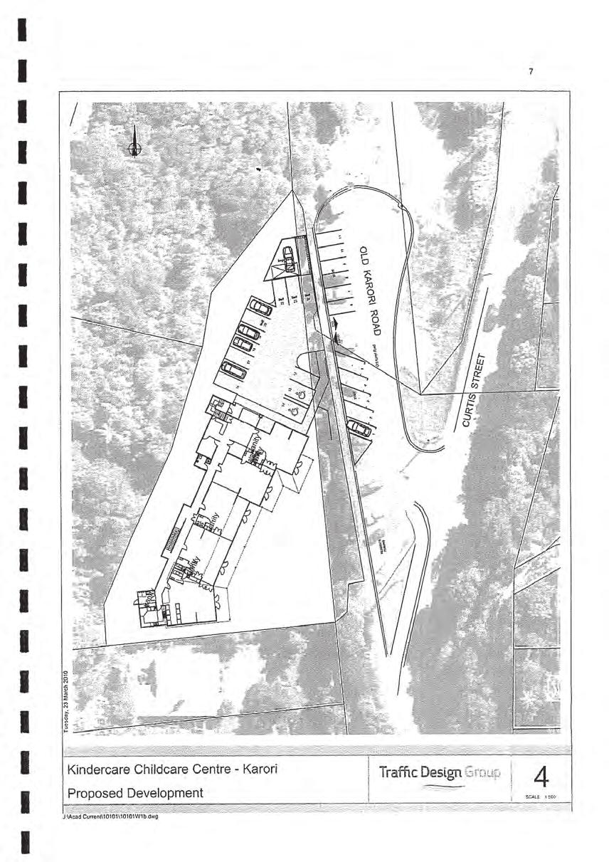
59
60
61
62
63
64
65
66
Harriet Fraser Traffic Engineering & Transportation Planning
 Appendix 5: Traffic Assessment 71 26 February 2015 Mr James Beban Senior Resource Consents Planner Cuttriss Consultants Ltd PO Box 30429 Lower Hutt PO Box 40170 Upper Hutt 5140 P 04 526 2979 M 027 668
TRANSPORTATION ANALYSIS REPORT US Route 6 Huron, Erie County, Ohio
 TRANSPORTATION ANALYSIS REPORT US Route 6 Huron, Erie County, Ohio December 12, 2012 Prepared for: The City of Huron 417 Main Huron, OH 44839 Providing Practical Experience Technical Excellence and Client
Ministry of Education Flat Bush School Notice of Requirement. Integrated Transportation Assessment Report. February 2016
 Ministry of Education Flat Bush School Notice of Requirement Integrated Transportation Assessment Report February 2016 TDG Ref: 12988-2 151105 ita flat bush.docx Ministry of Education Flat Bush School
Traffic Impact Study WestBranch Residential Development Davidson, NC March 2016
 Traffic Impact Study WestBranch Residential Development Davidson, NC March 216 TRAFFIC IMPACT STUDY FOR THE WestBranch Residential Development LOCATED IN DAVIDSON, NC Prepared For: Lennar Carolinas, LLC
Kings College, Otahuhu Proposed Plan Change. Integrated Transportation Assessment Report
 Proposed Plan Change Integrated Transportation Assessment Report 23 October 2017 Project: Report title: Document reference: Kings College, Otahuhu Integrated Transportation Assessment Report J00700 Kings
5858 N COLLEGE, LLC N College Avenue Traffic Impact Study
 5858 N COLLEGE, LLC nue Traffic Impact Study August 22, 2016 Contents Traffic Impact Study Page Preparer Qualifications... 1 Introduction... 2 Existing Roadway Conditions... 5 Existing Traffic Conditions...
Truck Climbing Lane Traffic Justification Report
 ROUTE 7 (HARRY BYRD HIGHWAY) WESTBOUND FROM WEST MARKET STREET TO ROUTE 9 (CHARLES TOWN PIKE) Truck Climbing Lane Traffic Justification Report Project No. 6007-053-133, P 101 Ι UPC No. 58599 Prepared by:
TRAFFIC STUDY GUIDELINES Clarksville Street Department
 TRAFFIC STUDY GUIDELINES Clarksville Street Department 9/1/2009 Introduction Traffic studies are used to help the city determine potential impacts to the operation of the surrounding roadway network. Two
Traffic Impact Analysis Chatham County Grocery Chatham County, NC
 Chatham County Grocery Chatham County, NC TABLE OF CONTENTS 1. INTRODUCTION... 1 1.1. Location and Study Area... 1 1.2. Proposed Land Use and Access... 2 1.3. Adjacent Land Uses... 2 1.4. Existing ways...
Chapter 4 Traffic Analysis
 Chapter 4 Traffic Analysis PURPOSE The traffic analysis component of the K-68 Corridor Management Plan incorporates information on the existing transportation network, such as traffic volumes and intersection
Traffic and Transport Assessment
 Traffic and Transport Assessment Section 96 Residential Subdivision, Davis Road Tarneit CG120370 Prepared for Stockland Pty Ltd 19 February 2013 Document Information Prepared for Stockland Pty Ltd Project
Appendix 5 Traffic Assessment
 Appendix 5 Traffic Assessment 44 Harrison Transportation Best Start Educare Shelly Bay Road Beachlands Transportation Assessment Report September 2017 PO Box 11 557 Palm Beach Papamoa 3151 Reference: 187
OFFICE/RETAIL DEVELOPMENT 1625 BANK STREET OTTAWA, ONTARIO TRANSPORTATION BRIEF. Prepared for: Canada Inc.
 OFFICE/RETAIL DEVELOPMENT 1625 BANK STREET OTTAWA, ONTARIO TRANSPORTATION BRIEF Prepared for: 9402209 Canada Inc. December 15, 2015 115-625 Report_2.doc D. J. Halpenny & Associates Ltd. Consulting Transportation
Project Report. South Kirkwood Road Traffic Study. Meadows Place, TX October 9, 2015
 Meadows Place, TX October 9, 2015 Contents 1 Introduction... 1 2 Data Collection... 1 3 Existing Roadway Network... 2 4 Traffic Volume Development... 2 5 Warrant Analysis... 3 6 Traffic Control Alternative
METHODOLOGY. Signalized Intersection Average Control Delay (sec/veh)
") Chapter 5 Traffic Analysis 5.1 SUMMARY US /West 6 th Street assumes a unique role in the Lawrence Douglas County transportation system. This principal arterial street currently conveys commuter traffic
Chapter 5 Traffic Analysis 5.1 SUMMARY US /West 6 th Street assumes a unique role in the Lawrence Douglas County transportation system. This principal arterial street currently conveys commuter traffic
SH1, Karo Drive Wellington Crash Reduction Study
 SH1, Karo Drive Wellington Crash Reduction Study A REPORT PREPARED FOR New Zealand Transport Agency Reference: 12334 January 2013 Hawke s Bay office: PO Box 28 208, Havelock North 4157 Tel: (06) 877 8040
Traffic Impact Study. Westlake Elementary School Westlake, Ohio. TMS Engineers, Inc. June 5, 2017
 TMS Engineers, Inc. Traffic Impact Study Westlake Elementary School Westlake, Ohio June 5, 2017 Prepared for: Westlake City Schools - Board of Education 27200 Hilliard Boulevard Westlake, OH 44145 TRAFFIC
HILTON GARDEN INN HOTEL HOTEL EXPANSION 2400 ALERT ROAD, OTTAWA TRANSPORTATION BRIEF. Prepared for:
 HILTON GARDEN INN HOTEL HOTEL EXPANSION 2400 ALERT ROAD, OTTAWA TRANSPORTATION BRIEF Prepared for: Bona Building & Management Co. Ltd. Place Vanier, 333 North River Road Vanier, Ontario K1L 8B9 October
Capital Region Council of Governments
 March 23, 2018 Capital Region Council of Governments PROJECT CONCEPT REPORT Realignment of Swamp and Northfield Road s approaches to Route 44 (Boston Turnpike) Town of Coventry SUMMARY: The Town of Coventry
9 Leeming Drive Redevelopment Ottawa, ON Transportation Brief. Prepared By: Stantec Consulting Ltd.
 9 Leeming Drive Redevelopment Ottawa, ON Transportation Brief Prepared By: Stantec Consulting Ltd. TIA GUIDELINES CHECKLIST Report Context Municipal Address Comment: Section 1.1 Location relative to major
INDUSTRIAL BUILDING 3009 HAWTHORNE ROAD CITY OF OTTAWA TRANSPORTATION OVERVIEW REVISED. Prepared for: Canada Inc.
 INDUSTRIAL BUILDING 3009 HAWTHORNE ROAD CITY OF OTTAWA TRANSPORTATION OVERVIEW REVISED Prepared for: 7849648 Canada Inc. Octiober 1, 2015 114-598 Overview_2.doc D. J. Halpenny & Associates Ltd. Consulting
Harrah s Station Square Casino
 Transportation Analysis Harrah s Station Square Casino Pittsburgh, Pennsylvania Submitted To: City of Pittsburgh and Pennsylvania Gaming Control Board Prepared By: DKS Associates GAI Consultants December
1609 E. FRANKLIN STREET HOTEL TRAFFIC IMPACT STUDY EXECUTIVE SUMMARY
 1609 E. FRANKLIN STREET HOTEL TRAFFIC IMPACT STUDY EXECUTIVE SUMMARY Prepared for: The Town of Chapel Hill Public Works Department Traffic Engineering Division Prepared by: HNTB North Carolina, PC 343
NMT SAFE STUDY APPROACH
 24 May 2017 ADVOCATING THE NON MOTORISED TRANSPORT AGENDA CONTENT Content NMT road safety study approach NMT road safety study process NMT SAFE STUDY APPROACH THE NEED FOR NMT SAFETY STUDIES Is there is
At each type of conflict location, the risk is affected by certain parameters:
 TN001 April 2016 The separated cycleway options tool (SCOT) was developed to partially address some of the gaps identified in Stage 1 of the Cycling Network Guidance project relating to separated cycleways.
TRAFFIC SIGNAL WARRANT STUDY
 TRAFFIC SIGNAL WARRANT STUDY 5 th STREET & ENCHANTED PINES DRIVE JANUARY 2013 TRAFFIC OPERATIONS ENGINEERING SERVICES/PUBLIC WORKS DEPARTMENT TABLE OF CONTENTS INTERSECTION LOCATION MAP ii INTRODUCTION
Table of Contents FIGURES TABLES APPENDICES. Traffic Impact Study Hudson Street Parking Garage MC Project No.: A Table of Contents
 Traffic Impact Study Hudson Street Parking Garage MC Project No.: 151714A Table of Contents Table of Contents I. INTRODUCTION... 2 II. EXISTING CONDITIONS... 5 III. 215 EXISTING TRAFFIC CONDITIONS... 6
MEDICAL/OFFICE BUILDING 1637 BANK STREET OTTAWA, ONTARIO TRANSPORTATION OVERVIEW. Prepared for:
 MEDICAL/OFFICE BUILDING 1637 BANK STREET OTTAWA, ONTARIO TRANSPORTATION OVERVIEW Prepared for: 2434984 Ontario Inc. 13-5510 Canotek Road Ottawa, Ontario K1J 9J5 June 4, 2015 115-613 Report_2.doc D. J.
TRAFFIC IMPACT ANALYSIS
 TRAFFIC IMPACT ANALYSIS FOR THE CHAMPAIGN UNIT#4 SCHOOL DISTRICT PROPOSED HIGH SCHOOL (SPALDING PARK SITE) IN THE CITY OF CHAMPAIGN Final Report Champaign Urbana Urbanized Area Transportation Study 6/24/2014
Traffic Impact Analysis Walton Acres at Riverwood Athletic Club Clayton, NC
 Traffic Impact Analysis Walton Acres at Riverwood Athletic Club Clayton, NC 1. TABLE OF CONTENTS INTRODUCTION...1 1.1. Site Location and Study Area...1 1.2. Proposed Land Use and Site Access...2 1.3.
City of Wayzata Comprehensive Plan 2030 Transportation Chapter: Appendix A
 A1. Functional Classification Table A-1 illustrates the Metropolitan Council s detailed criteria established for the functional classification of roadways within the Twin Cities Metropolitan Area. Table
OTTAWA TRAIN YARDS PHASE 3 DEVELOPMENT CITY OF OTTAWA TRANSPORTATION IMPACT STUDY. Prepared for:
 OTTAWA TRAIN YARDS PHASE 3 DEVELOPMENT CITY OF OTTAWA TRANSPORTATION IMPACT STUDY Prepared for: The Ottawa Train Yards Inc. 223 Colonnade Road South, Suite 212 Nepean, Ontario K2E 7K3 January 17, 2012
Statement of Evidence of Judith Makinson
 In the Matter of: The Resource Management Act 1991 and In the Matter of: Podium Sports Lodge, 18 20 Peake Road Application By: Brian Perry Charitable Trust Statement of Evidence of Judith Makinson TDG
RC25777 PROPOSED SERVICE CENTRE, 25 TE ARAHORI STREET, TURANGI REVIEW OF TRAFFIC ASSESSMENT FINAL
 19 April 2018 Louise Wood Senior Resource Consents Planner Taupō District Council Private Bag 2005 Taupō 3352 Gray Matter Ltd 2 Alfred Street PO Box 14178 Hamilton, 3252 Tel: 07 853 8997 170_02 Dear Louise
FAIRFIELD INN & SUITES HOTEL 135 THAD JOHNSON PRIVATE OTTAWA TRANSPORTATION BRIEF. Prepared for:
 FAIRFIELD INN & SUITES HOTEL 135 THAD JOHNSON PRIVATE OTTAWA TRANSPORTATION BRIEF Prepared for: Bona Building & Management Co. Ltd. Place Vanier, 333 North River Road Vanier, Ontario K1L 8B9 August 12,
INDUSTRIAL BUILDING 1660 COMSTOCK ROAD CITY OF OTTAWA TRANSPORTATION OVERVIEW. Prepared for:
 INDUSTRIAL BUILDING 1660 COMSTOCK ROAD CITY OF OTTAWA TRANSPORTATION OVERVIEW Prepared for: Simluc Contractors Limited 2550 Blackwell Street, Ottawa K1B 5R1 October 18, 2013 113-584 Overview_1.doc D. J.
PAEKĀKĀRIKI HILL ROAD / BEACH ROAD / SH1 INTERSECTION PROGRESS REPORT
 Chairperson and Committee Members ENVIRONMENT AND COMMUNITY DEVELOPMENT COMMITTEE 6 DECEMBER 2011 Meeting Status: Public Purpose of Report: For Decision PAEKĀKĀRIKI HILL ROAD / BEACH ROAD / SH1 INTERSECTION
QUICKIE C STORE AND GAS BAR 1780 HERON ROAD OTTAWA, ONTARIO TRANSPORTATION BRIEF. Prepared for:
 QUICKIE C STORE AND GAS BAR 1780 HERON ROAD OTTAWA, ONTARIO TRANSPORTATION BRIEF Prepared for: Quickie Convenience Stores Larny Holdings Ltd. c/o PBC Group April 15, 2015 115-615 Report_1.doc D. J. Halpenny
Walmart (Store # ) 60 th Street North and Marion Road Sioux Falls, South Dakota
 60 th Street North and Marion Road Sioux Falls, South Dakota") Walmart (Store #4865-00) 60 th Street North and Marion Road Sioux Falls, South Dakota Prepared for: Wal-Mart Stores, Inc. Bentonville, Arkansas Prepared by: Kimley-Horn and Associates, Inc. ã2013 Kimley-Horn
Walmart (Store #4865-00) 60 th Street North and Marion Road Sioux Falls, South Dakota Prepared for: Wal-Mart Stores, Inc. Bentonville, Arkansas Prepared by: Kimley-Horn and Associates, Inc. ã2013 Kimley-Horn
Ministry of Education Notice of Requirement, North City High School. Transportation Assessment Report. July 2010
 Ministry of Education Notice of Requirement, North City High School Transportation Assessment July 2010 PO Box 1261, Level 1, 7 Hardley Street Hamilton 3240 P: +64 7 839 550 www.tdg.co.nz New Zealand 10574ta_v6.doc
Shotover Country. Proposed Private Plan Change. Transportation Assessment Report. February 2010
 Shotover Country Proposed Private Plan Change February 2010 PO Box 13 835, Armagh Christchurch 8141 P: +64 3 379 2404 www.tdg.co.nz New Zealand Shotover Country Proposed Private Plan Change Quality Assurance
BETHEL ROAD AND SEDGWICK ROAD CORRIDOR STUDY
 DRAFT PLAN City Council Meeting August 14, 2017 STUDY AREA Sedgwick Corridor State Route 160, principal arterial with Class 3 access management designation, commuter and freight route, connection to SR
RIVER CROSSINGS: EAST OF SILVERTOWN CROSSINGS
 TRANSPORT FOR LONDON RIVER CROSSINGS: EAST OF SILVERTOWN CROSSINGS SUPPORTING TECHNICAL DOCUMENTATION TRAFFIC IMPACT REPORT Neil Georgeson July 2014 This report examines the traffic impacts that potential
AMETI PANMURE: A SUSTAINABLE TRANSPORT SOLUTION - OR NOT? Phil Harrison, Opus International Consultants
 IPWEA Conference: 7 June 11 June 2015 Abstract AMETI PANMURE: A SUSTAINABLE TRANSPORT SOLUTION - OR NOT? Phil Harrison, Opus International Consultants The AMETI project is a package of multi-modal transport
Grant Avenue Streetscape
 REPORT TYPE GOES HERE Grant Avenue Streetscape PREPARED FOR City of Manassas 9027 Center Street Manassas, VA 20110 PREPARED BY 8300 Boone Boulevard Suite 700 Vienna, Virginia 22182 571.389.8121 July 31,
1.3.4 CHARACTERISTICS OF CLASSIFICATIONS
 Geometric Design Guide for Canadian Roads 1.3.4 CHARACTERISTICS OF CLASSIFICATIONS The principal characteristics of each of the six groups of road classifications are described by the following figure
URBAN QUARRY HEADQUARTERS 2717 STEVENAGE DRIVE CITY OF OTTAWA TRANSPORTATION OVERVIEW. Prepared for: Urban Quarry 4123 Belgreen Drive, Ottawa K1G 3N2
 URBAN QUARRY HEADQUARTERS 2717 STEVENAGE DRIVE CITY OF OTTAWA TRANSPORTATION OVERVIEW Prepared for: Urban Quarry 4123 Belgreen Drive, Ottawa K1G 3N2 February 27, 2014 113-584 Overview_1.doc D. J. Halpenny
VIVA RETIREMENT COMMUNITIES OAKVILLE TRAFFIC IMPACT STUDY
 VIVA RETIREMENT COMMUNITIES OAKVILLE TRAFFIC IMPACT STUDY VIVA RETIREMENT COMMUNITIES OAKVILLE TRAFFIC IMPACT STUDY DECEMBER 2012 READ, VOORHEES & ASSOCIATES TORONTO, ONTARIO Read, Voorhees & Associates
Highway 111 Corridor Study
 Highway 111 Corridor Study June, 2009 LINCOLN CO. HWY 111 CORRIDOR STUDY Draft Study Tea, South Dakota Prepared for City of Tea Sioux Falls Metropolitan Planning Organization Prepared by HDR Engineering,
Traffic Circulation Study for Neighborhood Southwest of Mockingbird Lane and Airline Road, Highland Park, Texas
 ARIZONA TEXAS NEW MEXICO OKLAHOMA February 13, 2015 Mr. Meran Dadgostar P.E., R.S. Town of Highland Park 4700 Drexel Dr. Highland Park, Texas 75205 Re: Traffic Circulation Study for Neighborhood Southwest
HENDERSON DEVELOPMENT 213, 217, 221, 221 ½, 223 HENDERSON AVENUE and 65 TEMPLETON STREET OTTAWA, ONTARIO TRANSPORTATION OVERVIEW.
 HENDERSON DEVELOPMENT 213, 217, 221, 221 ½, 223 HENDERSON AVENUE and 65 TEMPLETON STREET OTTAWA, ONTARIO TRANSPORTATION OVERVIEW Prepared for: 2294170 Ontario Inc. February 2, 2017 117-652 Report_1.doc
Road Conversion Study Plumas Street
 Plumas Street Phase I Submitted to The Regional Transportation Commission of Washoe County Submitted by Zong Tian, Ph.D., P.E. Saeedeh Farivar Haiyuan Li, Ph.D. Center for Advanced Transportation Education
University Hill Transportation Study Technical Memorandum Alternatives Modeling and Analysis May 2007
 Technical Memorandum May 2007 Syracuse Metropolitan Transportation Council Edwards and Kelcey with Wallace Roberts and Todd Alta Planning and Design CONTENTS SECTION ONE- INTRODUCTION...1 SECTION TWO-
The Corporation of the City of Sarnia. School Crossing Guard Warrant Policy
 The Corporation of the City of Sarnia School Crossing Guard Warrant Policy Table of Contents Overview And Description... 2 Role of the School Crossing Guard... 2 Definition of a Designated School Crossing...
SH1 Western Belfast Bypass Transportation Assessment
 SH1 Western Belfast Bypass Transportation Assessment WBB- Transportation Assessment i This report has been prepared on behalf of the NZ Transport Agency (NZTA). No liability is accepted by this company
TRAFFIC IMPACT STUDY And A TRAFFIC SIGNAL WARRANT ANALYSIS FOR A SENIOR LIVING AND APARTMENT DEVELOPMENT
 TRAFFIC IMPACT STUDY And A TRAFFIC SIGNAL WARRANT ANALYSIS FOR A SENIOR LIVING AND APARTMENT DEVELOPMENT DEERFIELD TOWNSHIP, WARREN COUNTY, OHIO Nantucket Circle and Montgomery Road () Prepared for: ODLE
MEETING FACILITY 2901 GIBFORD DRIVE CITY OF OTTAWA TRANSPORTATION BRIEF. Prepared for: Holiday Inn Express 2881 Gibford Drive Ottawa, ON K1V 2L9
 MEETING FACILITY 2901 GIBFORD DRIVE CITY OF OTTAWA TRANSPORTATION BRIEF Prepared for: Holiday Inn Express 2881 Gibford Drive Ottawa, ON K1V 2L9 December 18, 2012 112-566 Brief_1.doc D. J. Halpenny & Associates
CITY OF OTTAWA ROADWAY MODIFICATION APPROVAL UNDER DELEGATED AUTHORITY
 RMA-2015-ATM-038 CITY OF OTTAWA ROADWAY MODIFICATION APPROVAL UNDER DELEGATED AUTHORITY DATE: April 22, 2015 SUBJECT Approval of Roadway Modifications Recommended through an Area Traffic Management Study
DUNBOW ROAD FUNCTIONAL PLANNING
 DUNBOW ROAD FUNCTIONAL PLANNING Final Report August 3, 216 #31, 316 5th Avenue NE Calgary, AB T2A 6K4 Phone: 43.273.91 Fax: 43.273.344 wattconsultinggroup.com Dunbow Road Functional Planning Final Report
TRAFFIC ASSESSMENT River Edge Colorado
 TRAFFIC ASSESSMENT River Edge Colorado Submitted by: Fehr & Peers 621 17th Street, Ste. 231 Denver, CO 8293 (33) 296-43 December, 21 App. M-2 Traffic Assessment River Edge Colorado December 21 TABLE OF
Auranga B1 Proposed Plan Change, Bremner Road, Drury. Integrated Transportation Assessment Report
 Auranga B1 Proposed Plan Change, Bremner Road, Drury Integrated Transportation Assessment Report 12 May 2017 Project: Report title: Document reference: Proposed Plan Change, Bremner Road, Drury Integrated
ENCOURAGING TAXI DRIVERS TO BEHAVE: GRAFTON BRIDGE TAXI AND BUS LANE TRIAL
 Encouraging Taxi Drivers to Behave Douglas-Jones, Segedin Page 1 ENCOURAGING TAXI DRIVERS TO BEHAVE: GRAFTON BRIDGE TAXI AND BUS LANE TRIAL Presenter: Rob Douglas-Jones, MEng, Traffic Operations Manager
Enclosure 1. Crimson Drive Traffic Safety and Calming Review Report
 Enclosure 1 Crimson Drive Traffic Safety and Calming Review Report Prepared by: Tahir Hameed, P.Eng. Traffic Safety Engineer Planning Engineering and Safety Transportation Planning and Engineering Date:
Evaluation of M-99 (Broad Street) Road Diet and Intersection Operational Investigation
 Road Diet and Intersection Operational Investigation") Evaluation of M-99 (Broad Street) Road Diet and Intersection Operational Investigation City of Hillsdale, Hillsdale County, Michigan June 16, 2016 Final Report Prepared for City of Hillsdale 97 North Broad
Evaluation of M-99 (Broad Street) Road Diet and Intersection Operational Investigation City of Hillsdale, Hillsdale County, Michigan June 16, 2016 Final Report Prepared for City of Hillsdale 97 North Broad
COMMERCIAL DEVELOPMENT 2015 ROBERTSON ROAD OTTAWA, ONTARIO TRANSPORTATION BRIEF. Prepared for:
 COMMERCIAL DEVELOPMENT 2015 ROBERTSON ROAD OTTAWA, ONTARIO TRANSPORTATION BRIEF Prepared for: First Bay Properties Inc. 311 Richmond Road, Suite 203 Ottawa, ON K1Z 6X3 August 8, 2017 117-663 Brief_1.doc
Cheyenne Metropolitan Planning Organization
 Dell Range Boulevard Corridor Study PHASE II SECTION 20 DRAFT Prepared for: Cheyenne Metropolitan Planning Organization November 20, 2015 (Section 20 is bordered by Powderhouse Road on the west, Storey
Traffic Impact Study Little Egypt Road Development Denver, North Carolina June 2017
 Traffic Impact Study Little Egypt Road Development Denver, North arolina June 2017 N. Little Egypt Road DQ\ QDQFLQJ VDOHV RU RWKHU SHUIRUPDQFH EDVHG FULWHULD Proposed Site Driveways Site Driveway 1 TRAFFI
Route 7 Corridor Study
 Route 7 Corridor Study Executive Summary Study Area The following report analyzes a segment of the Virginia State Route 7 corridor. The corridor study area, spanning over 5 miles in length, is a multi
TRAFFIC IMPACT STUDY
 TRAFFIC IMPACT STUDY for the GLEN ELLEN COUNTRY CLUB SENIOR RESIDENTIAL REDEVELOPMENT 84 Millis, Massachusetts Prepared by: McMahon Associates, Inc. Prepared for: Toll Brothers, Inc. August 216 DRAFT
TRAFFIC ADVISORY LEAFLET
 TRAFFIC ADVISORY LEAFLET 2/04 Rural traffic calming: Bird Lane, Essex INTRODUCTION Many rural communities are concerned about traffic growth and high vehicle speeds. Local authorities have to balance the
Henderson Avenue Mixed-Use Development
 Zoning Case: Z145-3 Traffic Impact Analysis Henderson Avenue Mixed-Use Development Dallas, TX October 26 th, 216 Kimley-Horn and Associates, Inc. Dallas, Texas Project #644827 Registered Firm F-928 Traffic
Statement of Rebuttal Evidence of Anthony Thomas Penny on Behalf of Danne Mora Holdings (#1134)
") In the Matter of: The Resource Management Act 1991 and In the Matter of: and The Christchurch Proposed Replacement District Plan under the Canterbury Earthquake (Christchurch Replacement District Plan)
In the Matter of: The Resource Management Act 1991 and In the Matter of: and The Christchurch Proposed Replacement District Plan under the Canterbury Earthquake (Christchurch Replacement District Plan)
Magnolia Place. Traffic Impact Analysis. Prepared for: City of San Mateo. Prepared by: Hexagon Transportation Consultants, Inc.
 Magnolia Place Traffic Impact Analysis Prepared for: City of San Mateo Prepared by: Hexagon Transportation Consultants, Inc. Updated January 4, 2010 Table of Contents 1. Introduction...1 2. Existing Conditions...6
Christchurch City Council Assets & Network Unit Transport Technical Services & Design
 Date: 6 th May 2014 From: To: Bill Homewood Transportation Engineer TOC Subject: Main South Road / Carmen Road Optimisation Budget Category: Network Optimisation Appendices Appendix 1 - Turning Counts
Transportation Impact Study for Abington Terrace
 Transportation Impact Study for Abington Terrace Abington Township, Montgomery County, PA Sandy A. Koza, P.E., PTOE PA PE License Number PE059911 Prepared by McMahon Associates, Inc. 425 Commerce Drive,
Update June 2018 OUR 2017 PUBLIC ENGAGEMENT
 Update June 2018 Hi, Let s Get Wellington Moving (LGWM) is developing a Recommended Programme of Investment (RPI) that meets our programme objectives and supports the city s and region s growth. As part
Glenn Avenue Corridor Traffic Operational Evaluation
 Glenn Avenue Corridor Traffic Operational Evaluation PREPARED FOR: THE CITY OF AUBURN PREPARED BY: DECEMBER 2007 Glenn Avenue Corridor Study--Auburn, Alabama TABLE OF CONTENTS Introduction... 1 Background
APPENDIX H EXISTING TRAFFIC CONDITIONS ANALYSIS
 APPENDIX H EXISTING TRAFFIC CONDITIONS ANALYSIS MEMO : Peter Steacy, P.Eng. Date: December 3, 2014 : Ian Borsuk, P.Eng. Job No.: 3414015-000 Subject: City of Ottawa O-Train Extension Planning & EA Study
M-58 HIGHWAY ACCESS MANAGEMENT STUDY Mullen Road to Bel-Ray Boulevard. Prepared for CITY OF BELTON. May 2016
 M-58 HIGHWAY ACCESS MANAGEMENT STUDY Prepared for CITY OF BELTON By May 2016 Introduction Missouri State Highway 58 (M-58 Highway) is a major commercial corridor in the City of Belton. As development has
Complete Street Analysis of a Road Diet: Orange Grove Boulevard, Pasadena, CA
 Complete Street Analysis of a Road Diet: Orange Grove Boulevard, Pasadena, CA Aaron Elias, Bill Cisco Abstract As part of evaluating the feasibility of a road diet on Orange Grove Boulevard in Pasadena,
TRAFFIC IMPACT STUDY CRITERIA
 Chapter 6 - TRAFFIC IMPACT STUDY CRITERIA 6.1 GENERAL PROVISIONS 6.1.1. Purpose: The purpose of this document is to outline a standard format for preparing a traffic impact study in the City of Steamboat
TECHNICAL NOTE THROUGH KERBSIDE LANE UTILISATION AT SIGNALISED INTERSECTIONS
 TECHNICAL NOTE THROUGH KERBSIDE LANE UTILISATION AT SIGNALISED INTERSECTIONS Authors: Randhir Karma NDip: Eng (Civil) B. Tech Eng (Civil) M Eng (Hons) (Transportation) Auckland Traffic Service Group Manager
Shockoe Bottom Preliminary Traffic and Parking Analysis
 Shockoe Bottom Preliminary Traffic and Parking Analysis Richmond, Virginia August 14, 2013 Prepared For City of Richmond Department of Public Works Prepared By 1001 Boulders Pkwy Suite 300, Richmond, VA
Traffic Analysis and Design Report. NW Bethany Boulevard. NW Bronson Road to NW West Union Road. Washington County, Oregon
 Traffic Analysis and Design Report NW Bethany Boulevard NW Bronson Road to NW West Union Road Washington County, Oregon May 2011 Table of Contents Table of Contents Section 1 Executive Summary... 2 Section
Community Advisory Committee
 Community Advisory Committee Meeting #1 November 19, 2014 Presentation Team Matt Fulda, Greater Bridgeport Regional Council Chris Granatini, P.E., Tighe & Bond Craig Yannes, P.E., PE PTOE, Tighe & Bond
Existing Conditions. Date: April 16 th, Dan Holderness; Coralville City Engineer Scott Larson; Coralville Assistant City Engineer
 Date: April 16 th, 2015 To: From: Re: Dan Holderness; Coralville City Engineer Scott Larson; Coralville Assistant City Engineer Darian Nagle-Gamm, Traffic Engineering Planner Highway 6 (2 nd Street) /
Technical Memorandum TRAFFIC IMPACT STUDY. RIDLEY ROAD CONVENIENCE STORE Southampton County, VA. Prepared for: Mr. David Williams.
 Technical Memorandum TRFFIC IMPCT STUDY RIDLEY ROD CONVENIENCE STORE Southampton County, V Prepared for: Mr. David Williams By: Charles Smith, P.E., PTOE EPR Charlottesville, V July 2014 1 TBLE OF CONTENTS
Stanley Street/Shotover Street, Queenstown. Traffic Modelling Report
 Stanley Street/Shotover Street, Queenstown Traffic Modelling Report Stanley Street/Shotover Street, Queenstown Traffic Modelling Report Prepared By Chris Morahan Transportation Engineer/Traffic Modeller
MEMORANDUM. Charlotte Fleetwood, Transportation Planner
 MEMORANDUM Date: Updated August 22, 2017 To: Organization: Charlotte Fleetwood, Transportation Planner Boston Transportation Department From: Jason DeGray, P.E., PTOE, Regional Director of Engineering
TRAFFIC IMPACT STUDY COMPREHENSIVE UPDATE TOWN OF THOMPSON S STATION, TENNESSEE PREPARED FOR: THE TOWN OF THOMPSON S STATION
 TRAFFIC IMPACT STUDY COMPREHENSIVE UPDATE TOWN OF THOMPSON S STATION, TENNESSEE PREPARED FOR: THE TOWN OF THOMPSON S STATION Transportation Consultants, LLC 1101 17 TH AVENUE SOUTH NASHVILLE, TN 37212
SECTION 1 - TRAFFIC PLANNING
 SECTION 1 - TRAFFIC PLANNING 1.1 TRAFFIC OPERATIONS 1.1.1 Roadway Functional Classification The Multnomah County Comprehensive Framework Plan s Policy 34: Trafficways and the Functional Classification
Evaluation and Changes to Pedestrian Priority Phase Signal (Scramble Crossing) at Bay Street and Bloor Street
 at Bay Street and Bloor Street") PW2.2 STAFF REPORT ACTION REQUIRED Evaluation and Changes to Pedestrian Priority Phase Signal (Scramble Crossing) at Bay Street and Bloor Street Date: February 12, 2015 To: From: Public Works and Infrastructure
PW2.2 STAFF REPORT ACTION REQUIRED Evaluation and Changes to Pedestrian Priority Phase Signal (Scramble Crossing) at Bay Street and Bloor Street Date: February 12, 2015 To: From: Public Works and Infrastructure
Northbound San Jose Avenue & I-280 Off-Ramp Road Diet Pilot Project
 Project Overview Fed by a two-lane Interstate-280 (I-280) off-ramp, high vehicular volumes and speeds are longstanding issues along San Jose Avenue. Residents in the surrounding neighborhoods have expressed
North West Non-Technical Summary of the Transport Assessment September 2011
 North West Non-Technical Summary of the Transport Assessment September 2011 Introduction This is a Non-Technical Summary of the findings of the Transport assessment work undertaken for the proposed North
1.5 On this basis it is fundamental that the Transport Strategy for the site focuses on the following key criteria,
 1.0 Introduction 1.1 The Transport Assessment has been prepared on behalf of Eon and Roger Bullivant Ltd in respect of the proposed mixed use sustainable urban extension of Drakelow Park. 1.2 The methodology
List of Attachments. Location Map... Site Plan... City of Lake Elsinore Circulation Element... City of Lake Elsinore Roadway Cross-Sections...
 List of Attachments Exhibits Location Map... Site Plan... City of Lake Elsinore Circulation Element... City of Lake Elsinore Roadway Cross-Sections... Existing Lane Geometry and Traffic Controls... Existing
2. Existing Conditions
 2. Existing Conditions The existing traffic and parking conditions on the site and the surrounding area were reviewed based on the study methodology in Section 1.2. 2.1 Existing Land Use The portion of
Chapter 16: Traffic and Parking A. INTRODUCTION
 Chapter 6: Traffic and Parking A. ITRODUCTIO This chapter examines the potential traffic and parking impacts of the proposed Fresh Kills Park roads. The analysis of transit and pedestrians is presented
Intersection of Massachusetts Avenue and Maple Street in Lexington Signalized Intersection and Roundabout Comparison
 Intersection of Massachusetts Avenue and Maple Street in Lexington Signalized Intersection and Roundabout Comparison Michael Wallwork, Roundabout Expert, Orange Park, Florida Tom Bertulis (MS, PE, PTOE),
Traffic Impact Analysis
 Traffic Impact Analysis Isle of Capri Casinos, Inc. Waterloo, Iowa SEH No. A-CLAAS0501.00 November 16, 2004 Table of Contents (Continued) Table of Contents Certification Page Table of Contents Page 1.0