San Bernardino County Non-Motorized Transportation Plan - Chapter 5
|
|
|
- Vanessa Francis
- 5 years ago
- Views:
Transcription
1 City of Yucaipa Population 51,476 City Overview Yucaipa is located in the eastern portion of the San Bernardino Valley area, at the foot of the San Bernardino Mountains, between the Cities of Redlands and Calimesa. The City is bounded on the northwest by the Crafton Hills, on the south by the City of Calimesa and on the north and east by mountainous terrain in unincorporated areas of San Bernardino County. The topography of the City begins at an approximate elevation of 2,000 feet at the west end, adjacent to the point at which the 10 freeway enters Yucaipa from the west. Elevations increase in the northeast and eastern portions of the City to approximately 4,000+feet, which represents an elevation change of 2,000 feet. Much of the area on the northwest portion of the City above 2,400 feet has been designated by the City as an open space preserve. Land Use The map on the following page shows the current and future land use patterns in the City of Yucaipa. The existing land uses within the City can be best summarized as a diversity of land uses throughout with a very low percentage of commercial and industrial land uses. The industrial and commercial areas have been developed in strips as opposed to centers or nodes of development. Existing Conditions: Yucaipa s non-motorized bicycle network has expanded significantly since the last update to the Non-Motorized Transportation Plan. The City now enjoys one Class I bikeway along a section of Oak Glen Road for a stretch of 2.06 miles. The City has also striped miles of Class II bike lanes, mostly on major transportation corridors throughout the City. The bike lanes provide connectivity to commercial, residential, educational, public transportation centers and recreational amenities throughout the city

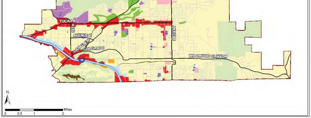
2 Figure

3 Figure
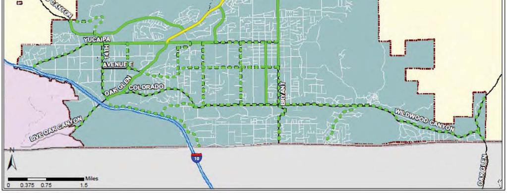
4 Table 5.110: Yucaipa Existing Conditions Street/Path From To Class Mileage Cost 5th St Oak Glen Rd Yucaipa Blvd II 0.82 $41,000 Bryant St SR-38 Avenue E II 3.91 $195,500 California St Avenue D Yucaipa Blvd II 1.25 $62,500 Chapman Heights Rd Sand Canyon Rd Oak Glen Rd II 1.86 $93,000 Oak Glen Rd 2nd St Yucaipa Blvd I 2.06 $2,060,000 Oak Glen Rd Bryant St 2nd St II 0.50 $25,000 Oak Glen Rd Cherry Croft Dr Bryant St II 0.87 $43,500 Oak Glen Rd Yucaipa Blvd Calimesa Blvd II 1.70 $85,000 Sand Canyon Rd N City Limit Yucaipa Blvd II 0.92 $46,000 Yucaipa Blvd 15th St 5th St II 4.19 $209,500 Total $2,861,000 Growth/Past investment in system Since the San Bernardino County Non-Motorized Transportation Plan was first prepared in 2001, the City of Yucaipa has constructed 2.1 miles of Class I and 13.9 miles of Class II facilities at a rate of 2.01 miles per year. Past Investment in Non-Motorized Infrastructure The improvements included in Table 5.110: above constitute a significant investment into the non-motorized transportation infrastructure of Yucaipa. Based on planning level estimates, the value of the improvements implemented throughout the City is $2,861,000. Proposed Improvements Future improvements to the non-motorized network for the City of Yucaipa will continue along the major transportation corridors throughout the City. All future improvements focus on further development of additional Class II facilities. A table of future improvements is included in Table 5.111: below. The City of Yucaipa has identified two projects as priorities, and the projects are included in Table 5.112: below. The projects focus on finishing the Class II improvements along Yucaipa Blvd. When complete, the City will have constructed an additional 2.5 miles of Class II improvements along the primary arterial roadway of the City
5 Table 5.111: Yucaipa Future Improvements Street/Path From To Class Mileage Est. Cost 12th St Yucaipa Blvd Ave E II 0.50 $25,000 14th St Yucaipa Blvd Oak Glen Rd II 1.11 $55,500 3rd St Yucaipa Blvd Wildwood Canyon Rd II 1.25 $62,500 6th St Yucaipa Blvd Wildwood Canyon Rd II 1.26 $63,000 7th St Yucaipa Blvd Washington Dr II 0.09 $4,500 8th St Washington Dr Ave E II 0.53 $26,500 Ave E 12th St Bryant St II 3.10 $155,000 Bryant St Ave E County Line Rd II 1.68 $84,000 Calimesa Blvd Oak Glen Rd S City Limit II 2.26 $113,000 Campus Dr Sand Canyon Rd Sand Canyon Rd II 1.10 $55,000 Colorado St Oak Glen Rd Wildwood Canyon Rd II 1.64 $82,000 Live Oak Rd W City Limit I-10 II 0.62 $31,000 Mesa Grande Dr Wildwood Canyon Rd County Line Rd II 1.05 $52,500 Oak Glen Rd Cherry Croft Dr e/o Martell Ave II 1.38 $69,000 Oak Glen Rd Oak Glen Rd Scenic Crest Dr II 0.51 $25,500 Washington Dr 8th St 7th St II 0.25 $12,500 Wildwood Canyon Rd Calimesa Blvd Oak Glen Rd II 6.65 $332,500 Yucaipa Blvd 5th St Bryant St II 1.25 $62,500 Yucaipa Blvd I-10 15th St II 1.28 $64,000 Total $1,375,500 Table 5.112: Priority Improvements Street/Path From To Class Mileage Est. Cost Yucaipa Blvd 5th St Bryant St II 1.25 $62,500 Yucaipa Blvd I-10 15th St II 1.28 $64,000 Total 2.53 $126,500 Municipal Code Yucaipa Municipal Code , Chapter Transportation Control Sub-regional Implementation Program includes several design standards for residential and nonresidential development pertaining to the provision of bicycle parking. The design standards are as follows: Bicycle Parking Facilities New non-residential and multi-family (of 10 or more units) development or remodels of existing complexes (when discretionary review 5-178
6 is required) are required to include parking racks or secured lockers at a rate of 1 per 30 parking spaces with a minimum of a three-bike rack. Pedestrian and Bicycle Connections to Public Streets New non-residential and multi-family (of 10 or more units) are required to provide on-site pedestrian walkways an bicycle facilities to connect each building in the development to public streets. Shower Facilities New non-residential development meeting CMP thresholds (250 or more peak hour trips) are required to provide shower facilities for persons bicycling or walking to work at a minimum of one shower facility accessible to both men and women. End of Trip Facilities The City of Yucaipa has bike racks dispersed throughout the City, typically at retail centers and multi-unit housing complexes. Multimodal Connectivity The City of Yucaipa has the following multimodal facilities that interface with the nonmotorized transportation system. Table 5.113: Multimodal Connectivity Facility Facility Type Facility Location Yucaipa Blvd PNR Lot Ride Share Lot Hampton Rd Yucaipa Transit Center Multi-Modal Facility Yucaipa Blvd City-wide Bus Stops Bus Stops Throughout City Collisions Involving Bicyclists Table 5.114: Data for Collisions Involving Bicyclists Parameter Collision Rate Total # of Bicycle Collisions from Total # of Bicycle Fatalities from Average # of Bicycle Collisions Per Year 8.2 Average Bicycle Collision Rate per 1000/year Notes: 1. Rate is calculated using SWITRS collision data and population figures by the California Department of Finance 5-179
7 Safety and Education Programs The City sponsors an annual Bike Safety Rodeo. The activities are geared for kids from ages The event features complimentary bike and helmet inspections, as well as a bicycle safety course food and giveaways. In addition, the City also partners with the Yucaipa-Calimesa Joint Unified School District and the San Bernardino County Department of Public Health s Safe Routes to School Program. The City assists by conducting public workshops at various elementary schools throughout the City, by providing bicycle and pedestrian safety/education programs and by encouraging walking and bicycling to and from school
8 Town of Yucca Valley Population 21,292 City Overview The Town of Yucca Valley comprises an important administrative, commercial and business center for the Morongo Basin and Lower Mojave Desert region. Located in the south-central portion of San Bernardino County and a transitional area between the high and low deserts of southeastern California, the Town sits at a pivotal location in terms of the region s geology. Both resulting climate and geotechnical activity have shaped Yucca Valley. Land Use The Town encompasses over 38 square miles. Historically, development has been focused along, and been most intense, adjacent to State Highway 62, with progressively less dense and more scattered residential development north and south of Highway 62. Industrial land uses are found in a few scattered locations, and the Highway 62 corridor serves the Town and the region as an integrated mix of commercial businesses. The goals identified in Yucca Valley s General plan include maintaining a balance of mixed, functionally integrated land uses which meet general, social and economic needs and promoting a well-rounded community of desirable neighborhoods with a strong employment base and a variety of community facilities. Existing Conditions: The Town of Yucca Valley s bicycle transportation system is comprised solely of Class III bike routes. The miles of bike routes provide access to the both the north and south sections of Town, crossing SR-62 and SR

9 Figure

10 Figure
11 Table 5.115: Yucca Valley Existing Conditions Street/Path From To Class Mileage Est. Cost Acoma Tr. Onaga Tr. SR-62 III 0.60 $9,000 Avalon Ave. Paxton Rd. Barron Dr. III 0.16 $2,400 Barron Dr. Avalon Ave. Yucca Mesa Rd. III 1.04 $15,600 Blackrock Canyon Rd. San Marino Dr. End III 1.08 $16,200 Carmelita Circle Santa Barbara Dr. Santa Barbara Dr. III 1.15 $17,250 Joshua Ln. Onaga Tr. San Marino Dr. III 3.76 $56,400 La Contenta Rd. SR-62 Yucca Trail III 0.99 $14,850 Mohawk Tr. SR-62 Sunnyslope Dr. III 0.53 $7,950 Onaga Tr. Hopi Tr. Palomar Ave. III 3.50 $52,500 Palomar Ave. Yucca Trail. Joshua Ln. III 1.99 $29,850 Paxton Rd. SR-247 Avalon Ave. III 1.47 $22,050 Pioneertown Rd. Sunnyslope Dr. N. Town Limits III 0.82 $12,300 San Marino Dr. Joshua Ln. Black Rock Canyon Rd. III 0.06 $900 Santa Barbara Dr. Joshua Ln. Carmelita Circle. III 0.56 $8,400 SR-247 Sunnyslope Dr. Paxton Rd. III 0.47 $7,050 Sunnyslope Dr. Pioneertown Rd. SR-247 III 1.97 $29,550 Yucca Mesa Rd. SR-62 N. Town Limits III 2.14 $32,100 Yucca Trail La Contenta Rd. Palomar Ave. III 1.12 $16,800 Total $351,150 Growth/Past investment in system Since the San Bernardino County Non-Motorized Transportation Plan was first prepared in 2001, the Town of Yucca Valley has designated miles of Class III facilities within the Town at a rate of 2.3 miles per year. Past Investment in Non-Motorized Infrastructure The improvements included in Table 5.115: above demonstrate a commitment to non-motorized transportation within the Town of Yucca Valley. Based on planning level estimates, the value of the improvements implemented throughout the Town is $351,150. Proposed Improvements The future improvements identified by the Town of Yucca Valley will upgrade most of the existing Class III facilities to Class II standards. When complete, along with the construction of new Class I and Class II bikeways, the Town will have a total of miles of bikeways, improving the safety to cyclists and reinforcing their place in the Town s arterial system
12 Table 5.116: Yucca Valley Future Improvements Street/Path From To Class Mileage Est. Cost Acoma Tr. San Andreas SR-62 II 2.10 $105,000 Avalon Ave. Yucca Tr. SR-62 II 0.89 $44,500 Balsa Ave. Yucca Tr. Paxton Rd. II 1.08 $54,000 Black Rock Cyn. Rd. II 0.25 $12,500 Buena Vista Dr. Yucca Mesa Rd. SR-247 II 2.77 $138,500 Camino del Cielo Tr. Onaga Tr. Sunnyslope Dr. II 0.89 $44,500 Joshua Ln. Onaga Tr. San Marino Dr. II 3.80 $190,000 Kickapoo Tr. Onaga Tr. Yucca Tr. II 0.59 $29,500 Onaga Tr. Camino del Cielo Tr. Palomar Ave. II 4.38 $94,500 Palomar Ave. Yucca Tr. Joshua Ln. II 2.01 $100,500 Paxton Rd. SR-247 Avalon Ave. II 1.46 $73,000 Pioneertown Rd. Onaga Tr. Town Bndy. II 1.89 $94,500 Sage Ave. Onaga Tr. Sunnyslope Dr. II 1.04 $52,000 San Andreas Trail Joshua Ln. Acoma Tr. I 3.07 $3,070,000 San Marino Dr. Joshua Ln. Black Rock Cyn. Rd. II 0.08 $4,000 SR-247 Sunnyslope Dr. Paxton Rd. II 0.49 $24,500 Sunnyslope Dr. Camino del Cielo SR-247 II 3.11 $155,500 Warren Vista Ave. Yucca Tr. SR-62 II 0.42 $21,000 Yucca Mesa Rd. Yucca Tr. Buena Vista Dr. II 2.99 $149,500 Yucca Tr. Kickapoo Tr. Pioneertown Rd. III 0.64 $9,600 Yucca Tr. Sage Ave. La Contenta Rd. II 3.01 $150,500 Yucca Wash Trail SR-62 Avalon Ave. I 3.20 $3,200,000 Total $7,817,600 Municipal Code The Town of Yucca Valley has not adopted Municipal Code specific to non-motorized transportation or the placement of non-motorized transportation facilities. End of Trip Facilities The Town of Yucca Valley has bike racks dispersed throughout the Town, typically at retail centers, schools and multi-unit housing complexes. The Town of Yucca Valley also possesses bicycle lockers at the park-and-ride facility located at the intersection of SR-62 and Kickapoo Trail. Multimodal Connectivity Table 5.117: 5-185
13 Location of Multi-Modal Connections Facility Facility Type Facility Location Yucca Valley Transfer Center Bus Transfer Center Yucca Trail/Airway Yucca Valley PNR Ride Share Lot 7485 Kickapoo Trail City-wide Bus Stops Bus Stops Throughout City Collisions Involving Bicyclists Table 5.118: Data for Collisions Involving Bicyclists Parameter Collision Rate Total # of Bicycle Collisions from Total # of Bicycle Fatalities from Average # of Bicycle Collisions Per Year 2.4 Average Bicycle Collision Rate per 1000/year Notes: 1. Rate is calculated using SWITRS collision data and population figures by the California Department of Finance Safety and Education Programs The Town of Yucca Valley does not currently participate in any bicycle safety or education programs
San Bernardino County Non-Motorized Transportation Plan - Chapter 5
 City of Victorville Population 112,097 City Overview Incorporated as a general law city in September 21, 1962, Victorville began its transition to a modern day community in about 1885, known then as the
San Bernardino County Non-Motorized Transportation Plan - Chapter 5
 City of Upland Population 76,106 City Overview The City of Upland was incorporated on May 15, 1906, after previously being named North Ontario. The City was originally established as an irrigation colony
City of San Bernardino
 City of San Bernardino Population 204,800 City Overview The City of San Bernardino is the largest City and the county seat of San Bernardino County, California. The City encompasses approximately 81 square
Bicycle Master Plan Goals, Strategies, and Policies
 Bicycle Master Plan Goals, Strategies, and Policies Mobilizing 5 This chapter outlines the overarching goals, action statements, and action items Long Beach will take in order to achieve its vision of
SANTA CLARA COUNTYWIDE BICYCLE PLAN August 2008
 SANTA CLARA COUNTYWIDE BICYCLE PLAN August 2008 To assist VTA and Member Agencies in the planning, development and programming of bicycle improvements in Santa Clara County. Vision Statement To establish,
Chapter 2. Bellingham Bicycle Master Plan Chapter 2: Policies and Actions
 Chapter 2 Bellingham Bicycle Master Plan Chapter 2: Policies and Actions Chapter 2: Policies and Actions The Bicycle Master Plan provides a road map for making bicycling in Bellingham a viable transportation
2.0 Existing Conditions
 20 2.0 Existing Conditions 2.1 Land Use, Future Growth Patterns, Physical Barriers Geographic Overview Sutter County s land use pattern is characterized by extensive agricultural areas, significant natural
Morongo Unified School District Yucca Valley High School La Contenta Middle School
 To School: YVHS 7:11 AM LCMS 7:08 AM Morongo Unified School La Contenta Middle School Bus Schedules: 2017/18 Area Route Page MV 1 Morongo Valley/Hwy 62 1 MV 2 Morongo Valley/Hwy 62 2 PIONEER 3 Pioneertown
 MEMORANDUM - CITY OF PASADENA Department Of Transportation DATE: OCTOBER 21, 2008 TO: ENVIRONMENTAL ADVISORY COMMISSION FROM: ~ FRED C. DOCK, DIRECTOR OF TRANSPORTATION SUBJECT: UPDATE ON DEPT. OF TRANSPORTATION
CONNECTING PEOPLE TO PLACES
 CONNECTING PEOPLE TO PLACES 82 EAST BENCH MASTER PLAN 07 Introduction The East Bench transportation system is a collection of slow moving, treelined residential streets and major arteries that are the
4. ENVIRONMENTAL IMPACT ANALYSIS 9. TRANSPORTATION AND TRAFFIC
 4. ENVIRONMENTAL IMPACT ANALYSIS 9. TRANSPORTATION AND TRAFFIC 4.9.1 INTRODUCTION The following section addresses the Proposed Project s impact on transportation and traffic based on the Traffic Study
Moraga Pedestrian and Bicycle Master Plan Update and Wayfinding Plan. Citizens Advisory Committee Meeting July 21, 2015
 Moraga Pedestrian and Bicycle Master Plan Update and Wayfinding Plan Citizens Advisory Committee Meeting July 21, 2015 Planning process Inventory of existing conditions 2 of 21 Planning process Inventory
NM-POLICY 1: Improve service levels, participation, and options for non-motorized transportation modes throughout the County.
 Transportation PRINCE WILLIAM COUNTY 2008 COMPREHENSIVE PLAN NON-MOTORIZED PLAN CONTENTS Goals, Policies, and Action Strategies Table 4 (Bike Facility Classifications and Descriptions) Table 5 (Bike Facility
ACTIVE TRANSPORTATION
 ACTIVE TRANSPORTATION Mobility 2040 Supported Goals Improve the availability of transportation options for people and goods. Support travel efficiency measures and system enhancements targeted at congestion
CITY OF COCOA BEACH 2025 COMPREHENSIVE PLAN. Section VIII Mobility Element Goals, Objectives, and Policies
 CITY OF COCOA BEACH 2025 COMPREHENSIVE PLAN Section VIII Mobility Element Goals, Objectives, and Policies Adopted August 6, 2015 by Ordinance No. 1591 VIII MOBILITY ELEMENT Table of Contents Page Number
o n - m o t o r i z e d transportation is an overlooked element that can greatly enhance the overall quality of life for the community s residents.
 N o n - m o t o r i z e d transportation is an overlooked element that can greatly enhance the overall quality of life for the community s residents. 84 Transportation CHAPTER 11 INTRODUCTION Transportation
Chapter 14 PARLIER RELATIONSHIP TO CITY PLANS AND POLICIES. Recommendations to Improve Pedestrian Safety in the City of Parlier (2014)
") Chapter 14 PARLIER This chapter describes the current status and future plans for biking and walking in the City of Parlier. RELATIONSHIP TO CITY PLANS AND POLICIES The Parlier General Plan is the primary
Chapter 14 PARLIER This chapter describes the current status and future plans for biking and walking in the City of Parlier. RELATIONSHIP TO CITY PLANS AND POLICIES The Parlier General Plan is the primary
West Dimond Blvd Upgrade Jodhpur Street to Sand Lake Road
 West Dimond Blvd Jodhpur St to Sand Lake CSS Transportation Project Summary Municipality of Anchorage Project # 05 005 Project Manager: John Smith, P.E. (MOA PM&E) Project Administrator: Julie Makela,
ACTIVE TRANSPORTATION/NONMOTORIZED TRANSPORTATION
 ACTIVE TRANSPORTATION/NONMOTORIZED TRANSPORTATION BACKGROUND Active transportation, also known as nonmotorized transportation, is increasingly recognized as an important consideration when planning and
Chapter 7. Transportation. Transportation Road Network Plan Transit Cyclists Pedestrians Multi-Use and Equestrian Trails
 Chapter 7 Transportation Transportation Road Network Plan Transit Cyclists Pedestrians Multi-Use and Equestrian Trails 7.1 TRANSPORTATION BACKGROUND The District of Maple Ridge faces a number of unique
TABLE OF CONTENTS. Executive Summary
 Executive Summary Background... ES-1 Pedestrian Network... ES-2 Bikeway Network... ES-2 Collision History... ES-2 Public Input... ES-4 Conclusions and Recommendations... ES-4 1. Introduction and Setting
Bike San Mateo County San Mateo County Bicycle Plan Recommendations August 30, 2010
 Policy and Procedures Develop and Implement a Complete Streets Policy to comply with DD-64-R1 and AB1358 Commencing January 1, 2011, AB1358 requires that the legislative body of a city or county, upon
Proposed White Flint Separated Bike Lane Network September 2015
 Proposed White Flint Separated Bike Lane Network September 2015 Abstract This report includes a proposed separated bike lane network for the White Flint Sector Plan area. Separated bike lanes create a
Goal 3: Foster an environment of partnerships and collaboration to connect our communities and regions to one another.
 Non-Motorized Transportation Plan (NMTP) Draft Vision, Goal and,, Tri-County Regional Planning Commission (TCRPC) Purpose The purpose of the Tri-County Regional Planning Commission (TCRPC) Non-Motorized
CITY OF BLOOMINGTON COMPLETE STREETS POLICY
 CITY OF BLOOMINGTON COMPLETE STREETS POLICY POLICY OBJECTIVE: The City of Bloomington will enhance safety, mobility, accessibility and convenience for transportation network users of all ages and abilities,
ACTION TRANSMITTAL No
 Transportation Advisory Board of the Metropolitan Council of the Twin Cities ACTION TRANSMITTAL No. 2016-15 DATE: January 14, 2016 TO: TAC Planning Committee PREPARED BY: Steven Elmer (651) 602-1756 SUBJECT:
KEARNY MESA COMMUNITY PLAN UPDATE
 KEARNY MESA COMMUNITY PLAN UPDATE January 18, 2018 SUBCOMMITTEE MEETING Mobility Concepts and Urban Design Presentation Outline Mobility Concepts: Multimodal Planning Toolbox Presentation and Activities
Bicycle Network Planning Report
 King County Bicycle Network Planning Report November 2017 What is the Bicycle Network Planning Report? 2016 King County Comprehensive Plan action item #11 Evaluation of existing King County bicycle planning
San Jose Transportation Policy
 San Jose Transportation Policy Protected Intersections in LOS Policies to Support Smart Growth Presented by: Manuel Pineda City of San Jose Department of Transportation Bay Area Map San Francisco Oakland
5 CIRCULATION AND STREET DESIGN
 5 CIRCULATION AND STREET DESIGN This chapter describes circulation and streetscape improvements proposed for the Northwest Chico Specific Plan Area. It includes detailed design specifications for existing
5/7/2013 VIA . RE: University Village Safeway Expansion (P13-019)
") 5/7/2013 VIA EMAIL David Hung, Associate Planner Community Development Department, Current Planning Division City of Sacramento 300 Richards Boulevard, 3 rd Floor Sacramento, CA 95811 RE: University Village
5/7/2013 VIA EMAIL David Hung, Associate Planner Community Development Department, Current Planning Division City of Sacramento 300 Richards Boulevard, 3 rd Floor Sacramento, CA 95811 RE: University Village
SUMMARY OF TRANSPORTATION INVESTMENTS
 Santa Cruz County 2016 Measure D: Transportation Improvement Expenditure Plan - Approved by over 2/3 of Santa Cruz County voters on November 8, 2016 - Overview Measure D, the 2016 Transportation Improvement
AMENDING MOTION: Mobility Plan - Pedestrians and Disadvantaged Communities
 I MOVE that the Council: AMENDING MOTION: Mobility Plan - Pedestrians and Disadvantaged Communities 1. INSTRUCT the Department of City Planning to amend the proposed Mobility Plan to include the following;
This page intentionally left blank.
 This page intentionally left blank. COMMUNITY Glenpool Community Overview Glenpool Glenpool is a city of nearly 12,000 residents located in Tulsa County southwest of Tulsa and Jenks. The city is growing
Chapter 13 ORANGE COVE
 Chapter 13 ORANGE COVE This chapter describes the current status and future plans for biking and walking in the City of Orange Cove. RELATIONSHIP TO CITY PLANS AND POLICIES The Orange Cove General Plan
5.13 Soledad. Demographic Profile. Disadvantaged Communities. Safety Profile
 5.13 Soledad Demographic Profile The City of Soledad is a small town in the Salinas Valley with 26,065 people, as reported by the California Department of Finance 2017 data. Soledad is a relatively young,
This chapter describes the proposed circulation system and transportation alternatives associated with
 5.0 Circulation 5.1 OVERVIEW This chapter describes the proposed circulation system and transportation alternatives associated with West Landing, and summarize the information contained in the Existing
Basalt Creek Transportation Refinement Plan Recommendations
 Basalt Creek Transportation Refinement Plan Recommendations Introduction The Basalt Creek transportation planning effort analyzed future transportation conditions and evaluated alternative strategies for
Clackamas County Comprehensive Plan
 ROADWAYS The County s road system permits the movement of goods and people between communities and regions, using any of a variety of modes of travel. Roads provide access to virtually all property. They
General Plan Circulation Element Update Scoping Meeting April 16, 2014 Santa Ana Senior Center, 424 W. 3rd Street, Santa Ana, CA 92701
 General Plan Circulation Element Update Scoping Meeting April 16, 2014 Santa Ana Senior Center, 424 W. 3rd Street, Santa Ana, CA 92701 Meeting Agenda 1. Purpose of Scoping Meeting 2. Project Overview 3.
Solana Beach Comprehensive Active Transportation Strategy (CATS)
") Solana Beach Comprehensive Active Transportation Strategy (CATS) 3.0 Goals & Policies The Solana Beach CATS goals and objectives outlined below were largely drawn from the Solana Beach Circulation Element
Solana Beach Comprehensive Active Transportation Strategy (CATS) 3.0 Goals & Policies The Solana Beach CATS goals and objectives outlined below were largely drawn from the Solana Beach Circulation Element
AGENDA ITEM NO. 5b HCAOG TAC meeting of May 8, 2014
 Humboldt County Association of Governments Eureka, CA, 95501 AGENDA ITEM NO. 5b HCAOG TAC meeting of May 8, 2014 DATE: May 1, 2014 TO: HCAOG Technical Advisory Committee (TAC) FROM:, SUBJECT: Letters of
City of Novi Non-Motorized Master Plan 2011 Executive Summary
 City of Novi Non-Motorized Master Plan 2011 Executive Summary Prepared by: February 28, 2011 Why Plan? Encouraging healthy, active lifestyles through pathway and sidewalk connectivity has been a focus
Active Transportation Access to Transit
 Active Transportation Access to Transit Introduction COMO Connect customers access transit service in many ways, including walking, bicycling, riding in a car and being dropped off, and directly boarding
Corpus Christi Metropolitan Transportation Plan Fiscal Year Introduction:
 Introduction: The Safe, Accountable, Flexible, Efficient Transportation Equity Act: A Legacy for Users (SAFETEA-LU) has continued the efforts started through the Intermodal Surface Transportation Efficiency
7/23/2017 VIA . Michael Hanebutt City of Sacramento Community Development Department 300 Richards Boulevard, 3 rd Floor Sacramento, CA 95811
 7/23/2017 VIA EMAIL Michael Hanebutt City of Sacramento Community Development Department 300 Richards Boulevard, 3 rd Floor Sacramento, CA 95811 RE: 65 th Street Apartments (DR17-220) Dear Mr. Hanebutt:
4 MOBILITY PLAN. Mobility Plan Objectives. Mobility Context. 1. Integrate with Local and Regional Transit Improvements
 Harbor Mixed Use CHAPTER Transit Corridor 4: Mobility Plan 4 MOBILITY PLAN Mobility Plan Objectives The Harbor Corridor Plan seeks to expand and improve the ways that people move along and through the
CPC Parking Lot Riverside Drive. Transportation Rationale
 CPC Parking Lot Transportation Rationale Prepared By: NOVATECH Suite 200, 240 Michael Cowpland Drive Ottawa, Ontario K2M 1P6 September 2015 Novatech File: 114093 Ref: R-2015-153 Table of Contents 1.0 INTRODUCTION...
This page intentionally left blank.
 This page intentionally left blank. COMMUNITY Coweta Community Overview Coweta Coweta, a residential community located in Wagoner County, is a suburb of Tulsa situated southeast of the metropolitan area
MAG Town of Cave Creek Bike Study Task 6 Executive Summary and Regional Significance Report
 Page 1 MAG Town of Cave Creek Bike Study Task 6 Executive Summary and Regional Significance Report August 1, 2012 MAG Project #481 Page 2 Task 6 Executive Summary and Regional Significance Report Introduction
New Seward and 36 th Avenue Intersection Conceptual Design
 University of Alaska Anchorage New Seward and 36 th Avenue Intersection Conceptual Design Prepared By: Zaid S. Hussein Dana Menendez Galen Jones Civil Engineering Department Prof. Osama Abaza CE A404 Highway
Bicycle and Pedestrian Chapter TPP Update Overview. TAB September 20, 2017
 Bicycle and Pedestrian Chapter TPP Update Overview TAB September 20, 2017 Bicycling & Walking in the Twin Cities Where are we now? The Bike-Pedestrian system Current trends New developments Where are we
COWETA HIGH SCHOOL AND EAST HIGHWAY 51
 COWETA HIGH SCHOOL AND EAST HIGHWAY 51 Lack of sidewalks along Ben Lumpkin Rd. Lack of crosswalks and ramps at intersection. Hwy 51 is wide to cross as a pedestrian. No ADA compliance or connection to
LEMON GROVE BIKEWAY MASTER PLAN UPDATE
 LEMON GROVE BIKEWAY MASTER PLAN UPDATE GENERAL PLAN AMENDMENT GPA06-001 ADOPTED NOVEMBER 1, 2006 Prepared for: City of Lemon Grove Prepared by: Alta Planning + Design 1. INTRODUCTION The Lemon Grove Bikeway
City of Gainesville Transportation/Roadway Needs PROJECT SUMMARY
 A1 Roadway Resurfacing $23,846,000 TYPE: Preservation of existing system Roadway resurfacing A2 Signal Replacement $6,000,000 TYPE: Preservation of existing system Replace traffic signals. B1 W 6th St
Circulation in Elk Grove includes: Motor vehicles, including cars and trucks
 Circulation, as it is used in this General Plan, refers to the many ways people and goods move from place to place in Elk Grove and the region. Circulation in Elk Grove includes: Motor vehicles, including
Chapter 6 Transportation Plan
 Chapter 6 Transportation Plan Transportation Plan Introduction Chapter 6 Transportation Plan Transportation Plan Introduction This chapter describes the components of Arvada s transportation system, comprised
2.0 Ballpark District
 2.0 Ballpark District 2.1 Introduction The Ballpark District is located in the south central portion of the City of Lake Elsinore, just north of the City limit line in this area. The Ballpark District
Lyons Avenue/Dockweiler Road Extension Project Draft Environmental Impact Report. Appendix I Traffic Impact Study
 Lyons Avenue/Dockweiler Road Extension Project Draft Environmental Impact Report Appendix I Traffic Impact Study Street 0 80-1947 500.4501 RITA ld Court 0 91355-1096 400.7401 LA n Avenue 0 590-3745 300-9301
Sixth Line Development - Transit Facilities Plan
 Memorandum Date: November 13, 2012 To: From: c.c. Subject: Rob Freeman (Freeman Planning) Kevin Phillips Sixth Line Development - Transit Facilities Plan 33016631 This memo was prepared to review the transit
CHAPTER 1 INTRODUCTION
 CHAPTER 1 INTRODUCTION Chapter Table of Contents THE 2017 HOUSTON BIKE PLAN 1-1 HOUSTON BIKEWAYS PROGRAM 1-2 HISTORY OF BICYCLE PLANNING IN HOUSTON 1-3 BICYCLE LEVEL OF COMFORT 1-3 EXISTING PLANS, PROGRAMS
We believe the following comments and suggestions can help the department meet those goals.
 The Honorable Secretary Anthony Foxx The Secretary of Transportation United States Department of Transportation 1200 New Jersey Avenue, SE Washington, DC 20590 August 30, 2013 Dear Secretary Foxx, Thank
SAFE ROUTES TO SCHOOL
 SAFE ROUTES TO SCHOOL Edgewood Elementary School Existing Conditions and ACTION PLAN > Oak Creek - Franklin Joint School District Table of Contents CONTEXT Enrollment Boundaries Enrollment
APPENDIX I: ROADWAY CLASSIFICATION SYSTEM AND PROJECT CONSISTENCY STANDARDS
 APPENDIX I: ROADWAY CLASSIFICATION SYSTEM AND PROJECT CONSISTENCY STANDARDS The Santa Barbara County Comprehensive General Plan Circulation Element Policy A states that: "The roadway classifications, intersection
Draft MOBILITY ELEMENET. Community Meeting May 22, 2013
 Draft MOBILITY ELEMENET Community Meeting May 22, 2013 Agenda Presentation Ira Brown New Mobility Paradigm Movement of People Implementation Q&A Ira Brown and Dave Roseman Small Group Discussion at Each
Non-Motorized Transportation 7-1
 Non-Motorized Transportation 7-1 Transportation facilities no longer mean just accommodating a vehicle powered by a combustion engine. Pedestrian and non-motorized facilities are important modes of travel
Board-Approved Funding Awards for Cycle 4 Active Transportation Grant Program Projects (in Order of Project Rankings) Approved on
 Approved on") CAPITAL Large Category Projects Board-Approved Funding Awards for Cycle 4 Active Transportation Grant Program Projects (in Order of Project Rankings) Approved on 07-27-18 1 La Mesa University Ave Pedestrian
CAPITAL Large Category Projects Board-Approved Funding Awards for Cycle 4 Active Transportation Grant Program Projects (in Order of Project Rankings) Approved on 07-27-18 1 La Mesa University Ave Pedestrian
COMMUNITY MEETING AGENDA
 COMMUNITY MEETING AGENDA Welcome and Introductions SAFE Presentation Project Presentation Priorities Feedback Next Steps Q&A Santa Cruz Avenue Corridor Study 1 Santa Cruz Avenue Corridor Study Community
Hennepin County Bicycle and Pedestrian Planning
 Hennepin County Bicycle and Pedestrian Planning 1 Value of bicycle and sidewalk systems Safety Livability Mobility Health Personal Finances Economic Sustainability Clean Air Recreation Parking and congestion
FINAL PLAN APPENDIX D CITY OF BERKELEY BIKE PLAN D-1
 CITY OF BERKELEY BIKE PLAN D-1 . Proposed Programs D.1. EDUCATION This appendix presents the recommended bicycle-related programs for the City of Berkeley. The recommendations are organized in four E s:
Bicycle Count Data. December 2008
 Bicycle Count Data December 28 Published By: San Luis Obispo Public Works Department 919 Palm Street, San Luis Obispo, California 9341 Telephone (85) 781 719; FAX (85) 781 7198 www.slocity.org Introduction
BIKE PLAN CONTENTS GATEWAY
 CONTENTS Acknowledgments...vii Great Rivers Greenway District Board of Directors... vii Great Rivers Greenway District Staff... vii Project Consultants... vii Committees... viii Citizens Advisory Committee
TOWN OF WILLIAMSTON, SC BICYCLE AND PEDESTRIAN MASTER PLAN TOWN OF WILLIAMSTON, SC BICYCLE AND PEDESTRIAN MASTER PLAN
 TOWN OF WILLIAMSTON, SC BICYCLE AND PEDESTRIAN MASTER PLAN Americans Want Choices 55% of Americans would rather drive less & walk more. Transit use is growing faster than population or highway travel.
SR-203 Sidewalks and Town-Wide Mobility Improvements. Town Council Presentation September 7, 2016
 SR-203 Sidewalks and Town-Wide Mobility Improvements Town Council Presentation September 7, 2016 SR-203 Sidewalks and Town- Wide Mobility Improvements SR-203 Sidewalks and Appurtenances Town-Wide Mobility
EXECUTIVE SUMMARY... vii 1 STUDY OVERVIEW Study Scope Study Area Study Objectives
 Contents EXECUTIVE SUMMARY... vii 1 STUDY OVERVIEW... 1-1 1.1 Study Scope... 1-1 1.2 Study Area... 1-1 1.3 Study Objectives... 1-3 2 EXISTING CONDITIONS... 2-1 2.1 Existing Freeway Conditions... 2-4 2.1.1
WELCOME. Thank you for joining us at the Second Public Workshop for the Carlsbad Pedestrian Master Plan. We look forward to receiving your feedback.
 City of Carlsbad Pedestrian Master Plan: WELCOME WELCOME Please Sign In Provide Input at Flip Charts Review Boards Presentation of Draft Plan Thank you for joining us at the Second Public Workshop for
BICYCLE MASTER PLAN CITY OF BURBANK ADOPTED DECEMBER 15, 2009
 CITY OF BURBANK BICYCLE MASTER PLAN ADOPTED DECEMBER 15, 2009 By a Resolution (Resolution number: 28-046) of the Council of the City of Burbank, this document was adopted and certified as being in compliance
Double the amount of bicycle ridership while at the same time reducing the number of bicycle crashes by one-third.
 CHAPTER 6 Recommended Policies and Action Items To achieve the goals stated in Chapter 1 and guide implementation of the Bicycle Plan, policies and action items have been identified. They are presented
SOLANA BEACH BICYCLE TRANSPORTATION PLAN SECOND ADDENDUM
 SOLANA BEACH BICYCLE TRANSPORTATION PLAN SECOND ADDENDUM Prepared by the City of Solana Beach January 2005 Introduction In June of 1993, the Solana Beach City Council adopted a Bikeway Master Plan as directed
HARRISON STREET/OAKLAND AVENUE COMMUNITY TRANSPORTATION PLAN
 HARRISON STREET/OAKLAND AVENUE Community Workshop #4: Draft Plan Review December 3, 2009 D E S I G N, C O M M U N I T Y & E N V I R O N M E N T INTRODUCTIONS Key Project Staff: Alisa Shen, Project Manager,
Governor s Transportation Vision Panel
 Office of Governor Kate Brown Governor s Transportation Vision Panel JLA Public Involvement Project Overview The is a yearlong effort to develop a series of recommendations for the Governor that address
City of Grover Beach Bicycle Master Plan
 City of Grover Beach Bicycle Master Plan City of Grover Beach Bicycle Master Plan Adopted January 2011 Prepared by: Firma Landscape Architects and Planners 187 Tank Farm Rd. Suite 230 San Luis Obispo CA
Rochester Downtown Bicycle Study 2009
 Rochester Downtown Bicycle Study 2009 Relationship of ROCOG Long Range Transportation Plan to Rochester Comprehensive Plan Regional Long Range Transportation Plan (LRTP) is prepared under the auspices
MASTER BICYCLE AND PEDESTRIAN PLAN
 VILLAGE OF NORTHBROOK MASTER BICYCLE AND PEDESTRIAN PLAN DRAFT PLAN OPEN HOUSE May 2, 2018 AGENDA 1. Community Engagement 2. Vision and Goals 3. General Structure of Plan 4. Recommendations Overview 5.
Route 7 Corridor Study
 Route 7 Corridor Study Executive Summary Study Area The following report analyzes a segment of the Virginia State Route 7 corridor. The corridor study area, spanning over 5 miles in length, is a multi
NON-MOTORIZED TRANSPORTATION
 NON-MOTORIZED TRANSPORTATION This chapter discusses bicycle and pedestrian initiatives, non-motorized goals and objectives, safety, education, and regional enforcement efforts, key area infrastructure,
New Measure A Expenditure Categories DEFINITIONS OF ELIGIBLE EXPENDITURES Adopted March 8, 2007
 New Measure A Expenditure Categories DEFINITIONS OF ELIGIBLE EXPENDITURES Adopted March 8, 2007 City Street and County Road Maintenance Program The preservation and keeping of public street and road rights-of-way
4 BICYCLING AND WALKING IN BUTTE COUNTY
 TRANSIT & NON-MOTORIZED PLAN EXISTING CONDITIONS REPORT DRAFT Butte County Association of Governments 4 BICYCLING AND WALKING IN BUTTE COUNTY INTRODUCTION According to the Non-Motorized Transportation
Executive Summary Route 30 Corridor Master Plan
 Route Corridor Master Plan Project Overview The Route Corridor Master Plan is a coordinated multimodal transportation and land use plan for the entire stretch of Route through East Whiteland Township,
Comprehensive Bicycle Master Plan 2014 ITE-IMSA Spring Conference March 6, 2014
 Comprehensive Bicycle Master Plan 2014 ITE-IMSA Spring Conference March 6, 2014 Street Transportation Department Inventory of Bikeways (October 7, 2013) 22 bike bridges 20 bike tunnels 420 miles of bike
The Traffic Monitoring Guide: Counting Bicyclists and Pedestrians. APBP 2017 June 28: 11:15am-12:45pm
 The Traffic Monitoring Guide: Counting Bicyclists and Pedestrians APBP 2017 June 28: 11:15am-12:45pm 2 Presentation Organization Why count bicyclists and pedestrians? Why report count data? What resources
APPENDIX A: Complete Streets Checklist DRAFT NOVEMBER 2016
 APPENDIX A: Complete Streets Checklist DRAFT NOVEMBER 2016 Complete Streets Checklist MetroPlan Orlando s Complete Streets Checklist is an internal planning tool for staff to further implementation of
Chapter 7 Nonmotorized Facilities
 Chapter 7 Nonmotorized Facilities What is in this chapter? This chapter discusses existing and proposed pedestrian and bicycle facilities referred to as nonmotorized facilities along the SR 520 corridor.
TRAFFIC ACTION PLAN. North Central Neighborhood CITY OF SAN MATEO
 TRAFFIC ACTION PLAN North Central Neighborhood CITY OF SAN MATEO Draft February 2017 Table of Contents Introduction... 1 The Traffic Forum Process... 4 Neighborhood Traffic Issues... 6 Neighborhood Recommendations
Chapter 5 FUNCTIONAL CLASSIFICATION
 Chapter 5 FUNCTIONAL CLASSIFICATION Functional classification is a system by which streets and roadways may be distinguished by types according to their function within the entire transportation network.
I-105 Corridor Sustainability Study (CSS)
") I-105 Corridor Sustainability Study (CSS) Metro Streets and Freeways Subcommittee March 21, 2019 Gary Hamrick Cambridge Systematics, Inc. I-105 CSS Project History & Background Funded by Caltrans Sustainable
I-105 Corridor Sustainability Study (CSS) Metro Streets and Freeways Subcommittee March 21, 2019 Gary Hamrick Cambridge Systematics, Inc. I-105 CSS Project History & Background Funded by Caltrans Sustainable
TRAFFIC IMPACT STUDY CRITERIA
 Chapter 6 - TRAFFIC IMPACT STUDY CRITERIA 6.1 GENERAL PROVISIONS 6.1.1. Purpose: The purpose of this document is to outline a standard format for preparing a traffic impact study in the City of Steamboat
GPATS Long-Range Transportation Plan. Complete Streets
 GPATS Long-Range Transportation Plan 5: BICYCLE AND PEDESTRIAN INTRODUCTION Complete Streets As the GPATS region grows, the role the active transportation infrastructure plays in the regional transportation
September The State of Bicycling in Montgomery County
 September 2015 The State of Bicycling in Montgomery County The State of Bicycling in Montgomery County Abstract: This report documents the state of bicycling in Montgomery County as of September 2015.
Welcome! San Jose Avenue Open House August 25, 2015
 Welcome! San Jose Avenue Open House August 25, 2015 Vision Zero The City and County of San Francisco adopted Vision Zero San Francisco Vision Zero High Injury Network as a policy in 2014, committing an