PAGHAM NEIGHBOURHOOD PLAN INFRASTRUCTURE GROUP
|
|
|
- Phebe Scott
- 5 years ago
- Views:
Transcription
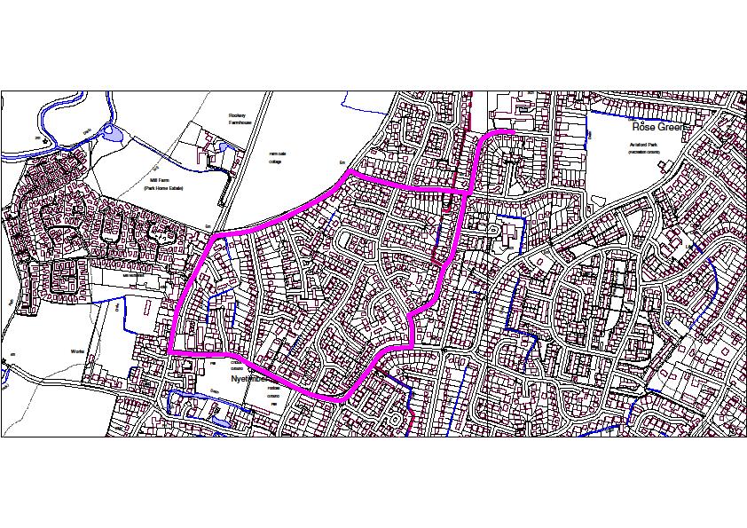
1 PAGHAM NEIGHBOURHOOD PLAN INFRASTRUCTURE GROUP SUMMARY OF FINDINGS AND PRIORITIES PARKING There was a high level of response to this topic which included many aspirations to provide car parking near to the beach and/or harbour and the shops in Nyetimber. To address the first requirement, we have looked at four possible sites; The Dell (area of land between Harbour Road and Lagoon Road at the end of Sea Lane) Land at the end of Sandy Lane adjacent to East Front Road The Spit Car Park at the west end of Harbour Road Slipe Field in Church Lane All these have positive points but there are equally challenging barriers to using any one of these sites. A fifth option was suggested, ie; the use of a Park and Ride scheme but this has been discounted on the basis of practicality and cost. Looking at the options, The Dell, Sandy Lane and Harbour Road all have similar challenges to development in that they all either exist on private land or require access over private land. In the case of Sandy Lane, this area also has SSSI status. Slipe Field is also privately owned but we believe that an opportunity may exist to work with the owner to produce a mutually beneficial solution for both the village and the owner. The downside of this location is simply that, its location. Access would be via the narrow Church Lane. Once vehicles are parked, their occupants would be close to the northern and eastern side of the harbour, they would be a considerable distance from the south side and the beach. Access to the beach is then made via the permissive path through Slipe Field or the path south from the Salthouse round the harbour edge and across the end of the Lagoon which would allow access to the existing Spit car park and the boardwalks to the beach. The other main downside is that this area of the beach has no facilities, ie; café, toilets, etc. and it could also be argued that if this location were selected, trade could be drawn away from the shops in the Parade and the traditional beach access area centred on the yacht club. With regard to parking by the shops in Nyetimber (ie; Tesco s), there is limited parking immediately outside the shops and the area regularly becomes congested. There is limited option for the other off road parking in the immediate vicinity due to the features on the road to the front of the shops, having; access to housing, a bus stop, pedestrian crossing, proximity to the junction with Nyetimber lane and The Inglenook and Bear public houses / restaurants nearby. There is a large car park adjacent to the shops but this is private property for the patrons of the Bear which is opposite the shops. It may be possible to come to a workable solution with the owner but current practice is for them to actively discourage parking by non- patrons.
2 CYCLING 28% of the respondents to the survey stated that they cycled regularly and around 50% felt that provision of cycleways would be beneficial to the community, however, the cyclist is not well served in Pagham. The spine roads are narrow rat runs for motorists and carry heavy freight vehicles to the adjacent nurseries. Some estate roads have also become rat runs. Twitterns (alleys) have either been closed or are prohibited to cyclists. Providing the following should advance safe cycling in the parish and should be read in conjunction with the parish map attached: Routes to Bognor Regis and Chichester Safe routes to Bognor are not available along the seafront and private estates restrict quiet road access. Bognor provides a wide range of shops, a rail link as well as employment. Butlins leisure activities in Bognor are to include cycle hire. This will require safe routes around and out of the town to include Pagham. A similar situation applies to safe routes between Pagham and Chichester although in this instance there are clear alternatives requiring upgrading of existing rights of way to the city and its secondary schools. The National Cycle Network Route 2 (NCN2) from Folkestone to Honiton has a significant gap between Bognor and Chichester and could be routed safely through Pagham. Action required; the footpaths noted on the map should be legally converted to bridleways or cycle ways. Permissive routes represent the simplest way forward requiring only the consent of the landowner. The twitterns currently restricted to pedestrian access should be incorporated into the cycle network where possible as shared routes. Routes to schools Bognor has one of our secondary schools, which should be accessible safely by cycle from Pagham. Secondary schools are also sited in Chichester and can be accessed by the routes indicated above. Primary Schools for Pagham children are sited in our neighbouring parish of Aldwick. There are currently no safe routes from the Pagham Beach area to the primary schools. Action required: as indicated on the map busy roads such as Nyetimber Lane and Cardinals Drive should be re- engineered for mixed use. Dedicated crossing places should be installed where indicated. Routes to local workplaces Most working people resident in Pagham work outside the parish and would be served by the routes indicated above accessing Bognor and Chichester. Within the parish horticulture is a major employer but the nurseries are all accessed from a narrow dangerous road (Pagham Road). This road is currently designated the South Coast Cycle Route but falls far short of the quiet rural route required. Local employers would welcome a safer alternative. Action required: provide a cycle path parallel to Pagham Road accessing nurseries and connecting to the bridleway to Banwell and South Mundham, providing an alternative route to Chichester.

3 Cycle Security Adequate cycle stands should be provided throughout the parish to allow cycles to be locked and immobilised. RIGHTS OF WAY (inc DISABILITY PROVISION A number of options have been considered and prioritised as shown below. High Priority Route A - Make the pavement/footway adjacent to public highways dual usage pavement and cycle route. The roads/ pathways to be considered are shown in yellow in the drawing below. These link the heavily populated areas to the shops at Pagham Parade and Nyetimber along with both primary schools. This will provide a safe, sustainable route for cyclists and mobility vehicles. This will involve working with WSCC to facilitate the dedication and marking of the route on the ground, some additional cycle awareness signs may be required.

4 Route B - A safe cycle route is needed for commuting (both to work and schools in Chichester) and for leisure, adjacent to Pagham Road and the B2166 up to the parish boundary at Runcton. Barfoots have already indicated that they would be willing to work with the parish to create a route over their land where it runs parallel to Pagham Road and the B2166 as their workers also need to access village facilities. Further advice may be needed to assess whether a formalised surface would be required. The route should also be dedicated as a bridleway which would provide a safe link for horse riders to ride from Nyetimber over to South Mundham via BW129. To make this happen there needs to be liaison between the landowner, parish and the PROW (Public Rights of Way) section at WSCC. In addition it is important to liaise with North Mundham parish to continue the route through the short section of B2166 to then pick up the bridleway network both sides of Vinnetrow Road which continues up to Chichester. Route C Creating a bridleway/cycle link from Nyetimber (Summer Lane) over to Honer Lane to then pick up the Sustrans Route 88 which runs from Chichester to the RSPB Visitor Centre at Sidlesham. This would also link into the future cycling routes being created as part of the Medmerry Realignment scheme. That then leaves a relatively short distance to cycle on public highway before linking in with the Chichester Harbour Conservancy route, the Saltern s Way, which takes you from West Wittering to Chichester. The project is already being worked on by Sustrans, the parish should actively work with assist and support Sustrans in making this route happen. The issue in the past with this route was, landowner consent to upgrade the path status from footpath to either bridleway or cycleway, over the


5 short section west from the Southern Water access track along Summer Lane, to where FP106 joins Honer Lane. Some surfacing may have been identified by Sustrans. Medium Priority Route D Create a cycle/bridleway route along Harbour Rd, along the harbours edge and North Wall. Would require landowner consent with a number of landowners who have an interest, there may also be limitations due to the Nature Reserve s protection status. Continuity through upgrading the Rights of Way network through North Mundham and Sidlesham Parishes to link to Route 88 and the RSPB Visitor Centre at Sidlesham is required. Surfacing work would be required in a number of locations.

6 Low Priority Route E Create a cycle/bridleway link from the B2166 through to Park Farm and onto Lagness. The route could then continue south to link into Aldwick. Work required to make this happen, landowner consent. Surface conditions are good from the B2166 to Lagness as it follows a concrete farm access track. South to Aldwick would need an assessment as to whether the surface would require upgrading. ALLOTMENTS Currently there are no allotments in Pagham. Over 200 people believe there is a very important need to provide allotments locally. A list of 12 people (names, addresses and phone numbers have been provided) expressing a desire for allotments exists already. In addition, 20 Pagham residents are on the waiting for an allotment in Aldwick. Given this level of interest, we believe this aspect should receive a high priority in the plan. The many allotment Acts that are in force state that if any six residents require allotments and there are none in the parish, the local authority has a statutory duty to provide them. The standard size for an allotment is 250 m 2 which gives approximately 40 to the hectare. Given that 32 are already required we require at least a hectare immediately. It is better to locate
7 allotments in one place which makes management, delivery of manure, water supply and car parking a lot easier. A potential site that has been identified is next to the village hall paddock. Providing additional allotment space could be a condition of granting permission for development of the housing we are required to take. OPEN SPACES AND IMPORTANT STRUCTURES No specific items of improvement/development were identified in the survey other than that the existing open spaces, trees and important structures should be conserved, maintained and protected to ensure these are available for future generations and to help retain the character of the village as it is now. Structures: - listed in appendix D of the Pagham neighbourhood plan survey report, probably the most important being: - Thomas a Becket Church, one of the oldest Parish Churches. The oldest continuously inhabited house near the Lamb pub The Mulberry harbour section off the Yacht Club in the middle of Pagham Bay. Several thatched cottages and the church farmhouse and storage barns storage barns not that well looked after at present! The beach estate has also been identified as an Area of Special Character. Open Spaces include the Green The Dell, the SSSI Nature reserve between East Front road and Sandy Lane the SSSI vegetated shingle of Pagham Beach the village hall Paddock the Football club Scout hut field The Pond adjacent to Sussex Drive and Lake View? AREAS WHICH ARE THOUGHT TO BE OUTSIDE THE REMIT OF THE NEIGHBOURHOOD PLAN ROADS AND PAVEMENTS Although many respondents were concerned about traffic speed and the condition of roads, we feel that this is a topic that cannot, or should not be, addressed in the Neighbourhood Plan. The same applies to the condition of pavements around the village. However, one area that perhaps should be considered though is the southern end of Harbour View Road where for approximately 200m, there is no footpath.
8 As these are primarily safety issues, we feel these should be addressed by the WSCC outside of the Neighbourhood Plan process. PUBLIC AND COMMUNITY TRANSPORT The main requirement identified by the residents was for better evening (ie; buses running at later times) and weekend services. These could potentially be achieved by reducing some services during the day time, eg; by changing the schedule from four buses/hour to three/hour.
9 APPEND
MILTON ROAD LLF PROJECT UPDATE
 Greater Cambridge City Deal MILTON ROAD LLF PROJECT UPDATE 9 th May 2017 Project objectives Comprehensive priority for buses in both directions wherever practicable; Additional capacity for sustainable
CUERDEN TRANSPORT PROPOSALS
 1 CUERDEN TRANSPORT PROPOSALS The transport assessment, submitted with the Cuerden development planning application, looks at access to the site and the impact on the local road network in detail. This
Improving Thetford Cycling Provision. In and Around Thetford
 Improving Cycling Provision In and Around Thetford Presentation to Thetford Town Council July 2015 About Me Lecturer in Mathematics at the University of East Anglia Keen recreational cyclist Volunteer
2. Context. Existing framework. The context. The challenge. Transport Strategy
 Transport Strategy Providing quality connections Contents 1. Introduction 2. Context 3. Long-term direction 4. Three-year priorities 5. Strategy tree Wellington City Council July 2006 1. Introduction Wellington
Summary and Analysis of feedback from the August Bank Holiday Fete 25 August 2014
 Summary and Analysis of feedback from the August Bank Holiday Fete 25 August 2014 Housing and Design Record of Comments from fete School Age Group : No Comments 18 30 Age Group : No Comments 30 60 Age
Oxfordshire Local Transport Plan 4 Science Vale Cycle Network Project Proposal Didcot Ladygrove Link
 Overview of project: The Ladygrove Link will provide a modern, direct, off-road, active travel route from the new Didcot North East development and new leisure centre to the strategic Cow Lane Tunnel.
HISTON ROAD Have your say on better public transport, cycling and walking journeys
 HISTON ROAD Have your say on better public transport, cycling and walking journeys Have your say: Please complete the survey inside this leaflet or online at www.greatercambridge.org.uk/histonconsultation
The Selsey Greenway Route Proposal to create a Shared-Use Traffic Free Route between Chichester and Selsey, West Sussex - draft 1
 The Selsey Greenway Route Proposal to create a Shared-Use Traffic Free Route between Chichester and Selsey, West Sussex - draft 1 A Route Proposal into the construction of a traffic-free, shared-use Commuter
The Cabinet Member for Highways & Streetscene. Aurang Zeb - Head of Highways & Transport
 LONDON BOROUGH OF RICHMOND UPON THAMES Cabinet Member Decision DATE: January 2012 REPORT OF: LEAD OFFICER: SUBJECT: WARDS: The Cabinet Member for Highways & Streetscene Aurang Zeb - Head of Highways &
Comments on the Hailsham to Eastbourne Sustainable Transport Corridor
 Comments on the Hailsham to Eastbourne Sustainable Transport Corridor Version 1.1 25/01/2015 Paul Humphreys 1 Table of Contents Version Control... 2 Summary... 2 Rationale provided by ESCC... 3 The ESCC
LEA BRIDGE ROAD - A STREET FOR EVERYONE Public consultation document
 LEA BRIDGE ROAD - A STREET FOR EVERYONE Public consultation document TELL US Bakers Arms to Leyton Green Road (Section D, E, F) Leyton Green Road to Whipps Cross Roundabout (Section G) YOUR VIEWS www.enjoywalthamforest.co.uk
Chelmsford City Growth Package
 Chelmsford City Growth Package Public Consultation Document Volume 2 West Chelmsford July - August 2017 Chelmsford City Growth Package Public Consultation Document - Volume 2 - West Chelmsford Contents
connectivity through walking and cycling
 active design case study the national forest: connectivity through walking and cycling active design principles in action: 1. ACTIVITY FOR ALL 2. WALKABLE COMMUNITIES 3. CONNECTED WALKING & CYCLING ROUTES
DESIGN CODE. Enterprise West Harlow London Road North Design Code 21
 DESIGN CODE Enterprise West Essex @ Harlow London Road North Design Code 21 4 MAXIMUM BUILDING HEIGHTS 4.1 Table 4A sets out maximum building height standards for each character area within the LDO boundary.
Local Highway Panels Members Guide. 9 Public Rights of Way
 Local Highway Panels Members Guide 9 2 Local Highway Panels (LHP) Members Guide 2016/17 1. Introduction There are 3927km of (PROW) in Essex, and it is one of the most extensive networks in the country.
EXECUTIVE SUMMARY Callan Park accommodates travel from a wide range of transport modes, including walking, cycling, bus and light rail.
 TRANSPORT AND ACCESS EXECUTIVE SUMMARY Callan Park accommodates travel from a wide range of transport modes, including walking, cycling, bus and light rail. Whilst there are some walking facilities within
High 2010 Medium 2010/11. PCT NHS Darlington Primary Care Trust HPC DBC DBC. High HPC. Med to High
 Hurworth Parish Plan 2010 Actions In this action plan cost ranges are: Low up to 499 Med - 500 to 4,999 High 5,000+ Very - Over 20,000 Hurworth Parish Council Darlington Borough Council MSG Middleton St
Chapter 5 Future Transportation
 Chapter 5 Future Transportation The Future Land Use Plan identifies the desired land use designations. The land uses desired for Crozet depend, in large part, on the success of the transportation system,
Appendix 12 Parking on footways and verges
 Appendix 12 Parking on footways and verges Legal position Parking on footways and verges whether wholly or partly is banned throughout London, unless signs are placed to allow parking. The ban requires
Road Safety in Radyr and Morganstown: the Community Council's response to Cardiff Council's draft scheme layout for highway improvements
 Road Safety in Radyr and Morganstown: the Community Council's response to Cardiff Council's draft scheme layout for highway improvements Introduction Radyr and Morganstown Community Council has been invited
1.5 On this basis it is fundamental that the Transport Strategy for the site focuses on the following key criteria,
 1.0 Introduction 1.1 The Transport Assessment has been prepared on behalf of Eon and Roger Bullivant Ltd in respect of the proposed mixed use sustainable urban extension of Drakelow Park. 1.2 The methodology
March Maidstone Integrated Transport Strategy Boxley Parish Council Briefing Note. Context. Author: Parish Clerk 2 March 2016
 Context. Author: Parish Clerk 2 The Draft Integrated Transport Policy (DITS) sets out a vision and objectives, and identifies a detailed programme of interventions to support the Maidstone Borough Local
Chapter 4 Route Window C3 Hyde Park and Park Lane shafts. Transport for London
 Chapter 4 Route Window C3 Hyde Park and Park Lane shafts Transport for London HYDE PARK AND PARK LANE SHAFTS 4 Route Window C3 Hyde Park and Park Lane shafts Introduction 4.1 In this route window, which
sessions. The opinions of local people will help decide which of these two options is taken forward to be built.
 A4018 FAQs Why are no bus lanes proposed north of Crow Lane? Inbound and outbound bus lanes were considered north of the Crow Lane junction, but they took away capacity from other traffic on the approach
Infrastructure Focus Group Report
 Infrastructure Focus Group Report Version history: 1. V1 circulated to Focus Group participants for comment on 5 July 2. V2 with minor amendments and the addition of appendix 1 circulated to Neighbourhood
Warfield Neighbourhood Plan: 4.4 Infrastructure
 Warfield Neighbourhood Plan: 4.4 Infrastructure Previously decided Policy headings: Policy WNP16 Transport Impact of Development Policy WNP17 Transport Proposals Policy WNP18 New School Buildings Policy
Devonport City Cycling Network Strategy
 Devonport City Cycling Network Strategy 2010-2013 Devonport City Cycling Network Strategy Introduction In February 2010 a draft master plan for cycleways was presented to the community. The feedback received
Nottingham Cycle City Frequently Asked Questions
 Nottingham Cycle City Frequently Asked Questions About the scheme How much money is to be spent on cycling? And where is the money from? We have 6.1 million in Growth Fund which we will be investing directly
Design Workshops Summary of all Feedback January 2017
 Histon Road Corridor Design Workshops Summary of all Feedback January 2017 CITY DEAL AND GROWTH Commitment to Growth: Government, County, City and District Emerging Local Plans: 33,000 new homes 45,000
The plan should be reviewed periodically i.e. each term in a school, following incidents or at least annually on other sites.
 Schools and Children s Services Sites Traffic Management Plan Guidance This guidance has been produced to assist headteachers and managers of LCC premises to identify and control the risks associated with
MARKHOUSE ROAD IMPROVEMENTS
 MARKHOUSE ROAD IMPROVEMENTS www.enjoywalthamforest.co.uk Waltham Forest is changing and we want you to be part of it. Thanks to a funding pot of 27million from Transport for London, we re delivering the
CHURCH ROAD. Public consultation document TELL US YOUR VIEWS.
 CHURCH ROAD Public consultation document YOUR TELL US VIEWS www.enjoywalthamforest.co.uk CHURCH ROAD Introduction Waltham Forest Council was one of three boroughs to be awarded 27million of funding from
PROPOSED RESIDENTIAL SUBDIVISION
 PROPOSED RESIDENTIAL SUBDIVISION PART OF TARNEIT ROAD & 1121 DOHERTYS ROAD, TARNEIT Prepared For: TCG (RM) Developments Pty Ltd MARCH 2014 OUR REF: 16740R#1 PROPOSED RESIDENTIAL SUBDIVISION PART OF TARNEIT
Hitchin Nomads Cycling Club
 Hitchin Nomads Cycling Club Risk Assessment of Course Course Identification 1U/25 25 Miles - Southill / Old Warden Reviewed By Paul Riley Reviewed On 02/01/2018 Course Details https://www.plotaroute.com/route/346809
A27 Worthing and Lancing: facilities for walking, cycling, and horse riding [nonmotorised
 A27 Worthing and Lancing: facilities for walking, cycling, and horse riding [nonmotorised users (NMUs)] Introduction This note describes our understanding of the needs of Non-Motorised Users (NMUs) as
Infrastructure Policies
 Infrastructure Policies 1. Primary Healthcare Health facilities in Ashtead comprise, Ashtead Private Hospital, two GP surgeries at Gilbert House and St Stephens, two Dental practices, the Arch and Tudor
Blyth Estuary Green Travel Project
 Blyth Estuary Green Travel Project Green Infrastructure Case Study Creating the UK s first Active Travel Town The Connect 2 Blyth Estuary Green Travel Project shows how green infrastructure can enable
CAIRNGORMS NATIONAL PARK AUTHORITY FOR DECISION
 CAIRNGORMS NATIONAL PARK AUTHORITY FOR DECISION Title: Prepared by: A9 Dualling Project: Dalraddy to Slochd Murray Ferguson, Director of Planning and Rural Development and Gavin Miles, Head of Planning
IMPACT OF THE BERMUDA CONNECTIVITY PROJECT ON CYCLING
 IMPACT OF THE BERMUDA CONNECTIVITY PROJECT ON CYCLING BBAG BRIEFING NOTE EMAIL: BERMUDABRIDGEAGP@BTINTERNET.COM WWW.FACEBOOK.COM/GROUPS/BERMUDABRIDGEAG TWITTER @BERMUDABRIDGEAG CYCLING BBAG BRIEFING NOTE
Launceston's Transport Futures. Greater travel options for the people of Launceston
 Launceston's Transport Futures Greater travel options for the people of Launceston Final Draft 13 Jan 2014 1 Page Number Executive summary 3 What is Transport Futures? 4 Vision 6 Economy, access and liveability
Roads and public rights of way
 Roads and public rights of way This factsheet outlines how the effects of the Proposed Scheme on roads and public rights of way (PRoW) along the line of route would be managed. Version 1.0 Last updated:
Heart of Hackbridge Consultation Feedback
 Heart of Hackbridge Consultation Feedback A summary of results gained from Heart of Hackbridge consultations to date March 2013 Funded by the Mayor s Outer London Fund and Sutton Council BioRegional Development
Active Travel Towns Funding Scheme Project Proposal. Sligo. Sligo Local Authorities
 Active Travel Towns Funding Scheme 2014-2016 Project Proposal for Sligo by Sligo Local Authorities Introduction Over the last two years, Sligo Local Authorities have implemented years 1 & 2 of their 5
CONNECTING PEOPLE TO PLACES
 CONNECTING PEOPLE TO PLACES 82 EAST BENCH MASTER PLAN 07 Introduction The East Bench transportation system is a collection of slow moving, treelined residential streets and major arteries that are the
ADOPTED BISHOPS LYDEARD & COTHELSTONE PARISH COUNCIL
 ADOPTED BISHOPS LYDEARD & COTHELSTONE PARISH COUNCIL Clerk to the Council: Mrs M Rousseau, West View, West Bagborough, TA4 3EG Phone: 01823 432 658 Email: clerk@bishopslydeard.org http://www.bishopslydeard.org.uk/
September HAWKHURST PARISH COUNCIL Page 1 of 13 SPORTS STRATEGY FINAL
 September 2017 HAWKHURST PARISH COUNCIL Page 1 of 13 SPORTS STRATEGY FINAL Table of Contents EXECUTIVE SUMMARY 3 1. INTRODUCTION 4 2. LOCAL CONTEXT 5 3. OBJECTIVES 7 4. PRIORITIES 8 5. FUNDING OPTIONS
Introduction. Prince Street Cycling Ambition Fund Public Realm Project
 Introduction The (CAF) project will create a high quality, 8-80 s cycle route up the west side of Prince Street from Cumberland Road, over Prince Street bridge to the Centre. This is part of the City Centre
Cabinet Member for Highways & Streetscene. Highway Infrastructure Manager
 LONDON BOROUGH OF RICHMOND UPON THAMES DATE: AUGUST 2015 DECISION MAKER: LEAD OFFICER: SUBJECT: WARDS: Cabinet Member for Highways & Streetscene Highway Infrastructure Manager PROPOSED CYCLING IMPROVEMENTS
Background. Caversham a vision for the future. Joint public meeting arranged by:
 Joint public meeting arranged by: Sharing our Streets Caversham a vision for the future and Caversham Traders Association This presentation followed a presentation by Simon Beasley, Network Manager for
The Wincheap Society
 The Wincheap Society s on sections of: Thanington 4th Arm Slip Road, Walking, Cycling & Horse-Riding Assessment & Review Report, by Peter Brett Associates, October 2017, on behalf of Pentland Properties
MAGNA PARK Lutterworth. DHL SUPPLY CHAIN: Design and Access Statement. June
 DHL SUPPLY CHAIN: Design and Access Statement June 2015 CONTENTS SECTION - The Access Proposals 9.1. Site Access 140 9.2. Mere Lane 140 9.3. A5 140 9.4. Footpaths, cycle ways and bridleways 142 SECTION
Chelmsford City Growth Package
 Chelmsford City Growth Package Public Consultation Document Volume 5 South and East Chelmsford July - August 27 Chelmsford City Growth Package Contents Introduction 5 Army and Navy Roundabout Improvements:
Danbury Words and pictures by Laurie Page of the Public Rights of Way team at Essex County Council.
 Danbury Words and pictures by Laurie Page of the Public Rights of Way team at Essex County Council. An undulating walk from Danbury village to the bluebells at the National Trust property of Blakes Wood.
Milton Road Project Update. Paul van de Bulk 30 January 2018
 Milton Road Project Update Paul van de Bulk 30 January 2018 Milton Road Project Objectives Comprehensive priority for buses in both directions wherever practicable; Safer and more convenient routes for
EXECUTIVE SUMMARY: TRANSIT-ORIENTED DEVELOPMENT IN SMITHS FALLS, ONTARIO; A COMPARISON BETWEEN TWO SITES
 EECUTIVE SUMMARY: TRANSIT-ORIENTED DEVELOPMENT IN SMITHS FALLS, ONTARIO; A COMPARISON BETWEEN TWO SITES Topic and Purpose In 2007, the Mayor of Ottawa s Task Force on Transportation suggested adding a
Active Transportation Facility Glossary
 Active Transportation Facility Glossary This document defines different active transportation facilities and suggests appropriate corridor types. Click on a facility type to jump to its definition. Bike
Appendix B Option 1 Design, Plans and Estimates
 19 Appendix B Option 1 Design, Plans and Estimates Opus International Consultants Ltd Design Details All options where designed using NZTA MOTSAM part 2, NCC Land development manual 2010 and Cycling
Chichester Harbour. A Walker s Guide
 A Walker s Guide - Chichester Harbour Chichester Harbour A Walker s Guide Chichester Harbour is an Area of Outstanding Natural Beauty on the south coast of Britain. Virtually flat with far reaching sea
Your views are important. Please fill in a form before you leave. Or alternatively
 Drum Property Group is delighted to welcome you to this exhibition which sets out our initial proposals for a mixed-use development at Stead s Place, Edinburgh. We are keen to hear the views of local people
Woolpit Neighbourhood Plan Community Consultation Summary Report
 Woolpit Neighbourhood Plan Community Consultation Summary Report Context Over a period of six months during 2016 the pop-up stand was used to gather comments on eight separate occasions, at various locations
London Cycle Network Annual Report 2000
 London Cycle Network Annual Report 2000 A cycle network for London by 2005 A cycle network for London by 2005 The London Cycle Network will: provide local links between residential neighbourhoods, railway
City of Perth Cycle Plan 2029
 Bicycling Western Australia s response City of Perth Cycle Plan 2029 2012-2021 More People Cycling More Often ABOUT BICYCLING WESTERN AUSTRALIA Bicycling Western Australia is a community based, not-for-profit
Lea Bridge Road A street for everyone Tell us
 Lea Bridge Road A street for everyone Tell us Public consultation document Section H your views 1 Lea Bridge Road: a street for everyone Introduction Mni-Holland is an exciting programme to improve walking
Dundalk Western Transportation Infrastructure. Supplementary Development Contribution Scheme
 Comhairle Baile Dhún Dealgan Dundalk Town Council Comhairle Chondae Lú Louth County Council Dundalk Western Transportation Infrastructure Supplementary Development Contribution Scheme Adopted by Louth
National Cycle Network Route 81 Wolverhampton Cross City Route August 2005
 Page 12 Buses often stop in Lichfield Street and there is no space to pass. Should an NCN route be following a road which is heavily congested with buses and diesel fumes? 14. Railway Drive The dropped
Martlesham Heath: January 23 rd 2014
 Public meetings - Roads & Transport responses Three public meeting were held in which members of the public were invited to give their views. This document contains the comments received. For each meeting
Douglas Land Use and Transportation Strategy (DLUTS) Summary. August 2013
 Summary. August 2013") Douglas Land Use and Transportation Strategy (DLUTS) Summary August 2013 Background Douglas is a large and popular residential suburb of approximately 30,000 persons on the periphery of Cork City along
Douglas Land Use and Transportation Strategy (DLUTS) Summary August 2013 Background Douglas is a large and popular residential suburb of approximately 30,000 persons on the periphery of Cork City along
Sevenways Roundabout, and the need for a Road Safety Scheme:
 Sevenways Roundabout, and the need for a Road Safety Scheme: The way the current roundabout has evolved has obviously created an environment that is dangerous for all road users, motorists, cyclists and
Phone: Ref No: 06/2018/0884
 Development Directorate Preston City Council Town Hall Lancaster Road Preston PR1 2RL FAO Ben Sandover Phone: 01772 533855 Email: david.allen@lancashire.gov.uk Ref No: 06/2018/0884 Date: 20 September 2018
FUTUREDMS 2018 CONSULTATION REPORT
 FUTUREDMS 2018 CONSULTATION REPORT Rev 1 17/08/2018 Sharing ideas of how to make amazing spaces and facilities better through the passion of talented people working together This document presents the
GLEN EIRA CITY COUNCIL. MURRUMBEENA Transforming our neighbourhood together our concepts based on your ideas
 GLEN EIRA CITY COUNCIL MURRUMBEENA Transforming our neighbourhood together our concepts based on your ideas 1 WHAT HAVE WE HEARD? WHAT NOW? Stage one Tell us what you love about your shopping strip November
Oxford Street West. 21 December https://consultations.tfl.gov.uk/roads/oxford-street/?cid=oxford-street
 Oxford Street West 21 December 2017 https://consultations.tfl.gov.uk/roads/oxford-street/?cid=oxford-street This consultation response is on behalf of the London Cycling Campaign (LCC), the capital s leading
EXECUTIVE SUMMARY OF CALEDON TRANSPORTATION NEEDS STUDY
 EXECUTIVE SUMMARY OF CALEDON TRANSPORTATION NEEDS STUDY The Caledon Transportation Needs Study has been undertaken as a joint project by the Town of Caledon and the Region of Peel to determine the existing
21.07 TRANSPORT CONNECTIVITY AND INFRASTRUCTURE
 21.07 TRANSPORT CONNECTIVITY AND INFRASTRUCTURE 21.07-1 Connectivity and Choice Transport connectivity and mode choice are critical to achieving productive, sustainable and socially just cities. Travel
Speed Limit Policy Isle of Wight Council
 APPENDIX B Speed Limit Policy Isle of Wight Council 2009 Contents Section 1 Introduction 1.1 Links with the Local Transport Plan Section 2 Speed Limits on Urban Roads and Residential Areas 2.1 20mph Limits
Sandwell General Hospital Travel Plan 2014
 Sandwell General Hospital Travel Plan 2014 Travel Plan Survey Dated 24 th June 2013 Travel plan finalised March 2014 Prepared by Michael Raynor, JMP Consultants Ltd Site Address Lyndon, West Bromwich,
Transportation Master Plan Advisory Task Force
 Transportation Master Plan Advisory Task Force Network Alternatives & Phasing Strategy February 2016 BACKGROUND Table of Contents BACKGROUND Purpose & Introduction 2 Linking the TMP to Key Council Approved
Regional Cycle Programme Update
 Agenda Item 10 (ii) Regional Cycle Programme Update Glossary Auckland Council Auckland Transport Cycle Action Auckland New Zealand Transport Agency Regional Cycle Network (AC) (AT) (CAA) (NZTA) (RCN) Executive
Hitchin Nomads Cycling Club
 Hitchin Nomads Cycling Club Risk Assessment of Course Course Identification 1U/10 10 Miles - Southill / Old / Warden / Ireland Circuit Reviewed By Nick Hickman Reviewed On 13/01/2018 Course Details START
Maps The maps provided are a guide and are not to scale. Please use OS Explorer Map 120 (Chichester).
.") A Walker s Guide - Chichester Harbour Useful Information Directions All the walks were tested in 201. Please note, however, that some footpaths may be diverted and buildings such as pubs may have changed
A Walker s Guide - Chichester Harbour Useful Information Directions All the walks were tested in 201. Please note, however, that some footpaths may be diverted and buildings such as pubs may have changed
ACV Community Engagement Feb/Mar 2015: Summary (Infrastructure issues highlighted in red)
") Ashtead Choral Society Best answer: Nothing (a follow up spoken comment was that it s just right Transport A solution to end the on street parking in Craddocks Parade area and surrounding roads. Traffic
Ashtead Choral Society Best answer: Nothing (a follow up spoken comment was that it s just right Transport A solution to end the on street parking in Craddocks Parade area and surrounding roads. Traffic
FAQ s Walsh Road / Ferguson Road Pilot Scheme
 FAQ s Walsh Road / Ferguson Road Pilot Scheme What is happening? Traffic calming measures are being installed as a pilot. Temporary Bollards will be installed to the east of 1 Ferguson Road and a Temporary
Develop a Multi-Modal Transportation Strategy (Theme 6)
") DEVELOP A MULTI-MODAL TRANSPORTATION STRATEGY (THEME 6) WHY IS THIS THEME ADDRESSED? Develop a Multi-Modal Transportation Strategy (Theme 6) Statement of Ideal Reduce resident and visitor reliance on single
DEVELOP A MULTI-MODAL TRANSPORTATION STRATEGY (THEME 6) WHY IS THIS THEME ADDRESSED? Develop a Multi-Modal Transportation Strategy (Theme 6) Statement of Ideal Reduce resident and visitor reliance on single
TRAVEL PLAN: CENTRAL EUROPEAN UNIVERSITY CAMPUS REDEVELOPMENT PROJECT TRAVEL PLAN. Central European University Campus Redevelopment Project.
 TRAVEL PLAN Central European University Campus Redevelopment Project Page 1 Table of Contents Introduction... 3 Background... 7 Building Users... 7 Transportation in Community Consultation... 7 Summary
A guide to how local communities can change local speed limits
 A guide to how local communities can change local speed limits The Council s approach to speed management Speeding continues to be one of the key road safety concerns being raised by local communities.
The Hundred Parishes
 The Hundred Parishes Walks from railway stations number 9 6.4 miles (10kms) from Bishop s Stortford to Stansted Mountfitchet Start: Bishop s Stortford station (Grid Reference TL492209) (ample parking and
Kingswood Primary School s Travel Plan
 Kingswood Primary School s Travel Plan Kingswood Primary School Cayser Drive Kingswood Maidstone Kent ME17 3QF 01622 842674 DCSF number 886-2578 Travel Plan Co-ordinator- Darren Waters ( headofschool@kingswood.kent.sch.uk)
PEDESTRIAN ACTION PLAN
 ATTACHMENT 2 CITY OF SANTA MONICA PEDESTRIAN ACTION PLAN CITY OF SANTA MONICA PEDESTRIAN ACTION PLAN This page intentionally left blank EXECUTIVE SUMMARY CHAPTER 1 EXECUTIVE SUMMARY Setting the Stage
The boards contain our dra Vision & Objec ves for Danbury.
 Welcome Thank you for visi ng today The boards contain our dra Vision & Objec ves for Danbury. We are also displaying a map of Danbury showing the sites that have been put forward to build the 100 new
School Traffic Management Plan
 School Traffic Management Plan School Name: Wilstead Primary School Manager with responsibility for Traffic Management Plan: Leon Robichaud Contact Number: 01234 302303 Contact Email: office@wilsteadlower.beds.sch.uk
SCHEME DESIGN AND ENGINEERING
 THE NORTH SOMERSET COUNCIL (SOUTH BRISTOL LINK CLASSIFIED ROAD) SIDE ROADS ORDER 2013 THE NORTH SOMERSET COUNCIL (SOUTH BRISTOL LINK) COMPULSORY PURCHASE ORDER 2013 THE NORTH SOMERSET COUNCIL (SOUTH BRISTOL
CHRISTCHURCH AND EAST DORSET Local Plan Review Options Consultation Response Form
 CHRISTCHURCH AND EAST DORSET Local Plan Review Options Consultation Response Form Name Steve Gerry Organisation (if any) North Dorset Trailway Network (reg charity 1145442) Address Line 1 Address Line
Site Traffic Management Plan
 Prescot Primary School Site Traffic Management Plan January 2017 (Next review date January 2018) 1. Introduction 2. Layout / Access 3. Pedestrians 4. Pupils / Students 5. Staff 6. Visitors 7. Servicing
Yorkhill & Kelvingrove Community Council Cycling Village Proposal. Yorkhill Kelvingrove Cycling Village (1.3)
") Yorkhill Kelvingrove Cycling Village (1.3) 1) Introduction In recent years our community has been transformed. We have seen additional student and residential accommodation constructed. The redevelopment
Yorkhill Kelvingrove Cycling Village (1.3) 1) Introduction In recent years our community has been transformed. We have seen additional student and residential accommodation constructed. The redevelopment
University of Victoria Campus Cycling Plan Terms of Reference. 1.0 Project Description
 University of Victoria Campus Cycling Plan Terms of Reference 1.0 Project Description The Campus Cycling Plan, a first for the University, will provide a comprehensive and coordinated approach to support
Traffic and transport: issues and objectives
 Traffic and transport: issues and objectives Our goal is to resolve the conflict between traffic, pedestrians, and community living through the introduction of initiatives designed to manage car-parking,
Transport Plan Adopted March 2012
 Burneside Parish Council Transport Plan Adopted March 2012 POLICY AREAS: TP1: Motor Vehicles TP2: Public Transport TP3: Cycling and Pedestrian Routes THE REPORT: 1. Scope of the Plan 2. Background 3. Local
National Cycle Network Funding Scheme 2012/2012 Application Form. Waterford City Council. Paul Cleary, Executive Engineer. 3.2km 289, ,000
 National Cycle Network Funding Scheme 2012/2012 Application Form Section 1:Project Outline Name and Address of Local Authority Contact person/proposed project manager Waterford City Council Paul Cleary,
Frascati Road and Temple Hill Route Improvements. Outline Design Report to Accompany Public consultation
 Frascati Road and Temple Hill Route Improvements Outline Design Report to Accompany Public consultation September 2013 Background: Dún Laoghaire-Rathdown is committed to providing high quality pedestrian
44biii. Introduction. 182 Movement and Transport
 44biii movement and transport Introduction The Movement and Transport Strategy for Sherford is an essential component of the vision for a sustainable town. The demand for travel that will arise from the