Staff Report City of Manhattan Beach
|
|
|
- Gillian Doreen Greer
- 5 years ago
- Views:
Transcription
1 Agenda Item #: Staff Report City of Manhattan Beach TO: THROUGH: FROM: Honorable Mayor Wilson and Members of the City Council Geoff Dolan, City Manager Richard Thompson, Director of Community Development Rob Osborne, Management Analyst DATE: January 4, 2005 SUBJECT: Consideration of the City Council s Work Plan Item Regarding Creation of a Citywide Bikeway System RECOMMENDATION: It is recommended that the Council discuss this issue and approve a City-wide bikeway system. FISCAL IMPLICATION: There is no cost associated with approving a City-wide bikeway system. Installation of signage to designate bike routes throughout the City, as recommended by the PPIC, would cost approximately $4,000. The Public Works Department has indicated that the labor could be provided through existing programs & budgets. The materials cost of approximately $4,000 could be appropriated from the Council Contingency Fund. Approving a bikeway plan would make the City eligible to pursue grant funding for bicycle-related projects. BACKGROUND: The City Council s Work Plan includes a task to determine if a City-wide bikeway system should be implemented in Manhattan Beach. Staff compiled a variety of information regarding such systems and presented it to the Parking and Public Improvements Commission for consideration at public meetings on October 28 and November 30, DISCUSSION: A "Bikeway" is defined as a facility that provides primarily for bicycle travel. There are three types: Class I Bikeway (Bike Path) - A completely separated right of way for the exclusive use of bicycles and pedestrians with minimized crossflow, such as the pathway through the City west of the Strand. State guidelines require a width of at least eight feet for two-way bicycle movement.
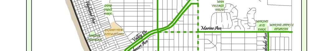
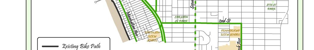
2 Agenda Item #: Class II Bikeway (Bike Lane) - A striped lane for one-way bike travel on a street or highway. The minimum width required is four feet where there is no curb parking and five feet adjacent to curb parking. Class III Bikeway (Bike Route) - Provides for shared use with pedestrian or motor vehicle traffic with design criteria and uniform symbols. No minimum widths are required, but routes should only be designated after considering such factors such as surface condition, obstructions, curb parking, and connections to other bikeways. Bike Paths are preferred for greatest overall safety and efficiency, but are difficult to achieve in built-out cities. Bike lanes provide generally safer riding conditions than Bike Routes, but require a dedicated area on the street. Bike Routes require the least amount of right-of-way and have fewer design requirements. The complexity of implementing a bikeway system can range from installing a number of Bike Route signs up to major capital improvement projects involving land acquisition and construction of off-street paths. General Plan Issues The City s General Plan includes several bicycle-oriented policies, including the following: Goal 6: Create well-marked pedestrian and bicycle networks that facilitate these modes of circulation. Policy I-6.6: Incorporate bikeways and pedestrian ways as part of the City s circulation system where safe and appropriate to do so. Policy I-6.7: Encourage features that accommodate the use of bicycles in the design of new development, as appropriate. Policy I-6.8: Encourage the development of Bikeways to link recreation areas and schools. The only Bikeway designated in the City s General Plan is The Strand Bikeway. If the City adopts a Citywide Bikeway Plan, several grant programs may become available for funding bicycle-related projects. Traffic Engineer Findings As described in detail in the attached report, the Traffic Engineer evaluated the possibility of creating a bikeway system in Manhattan Beach. Based on various criteria analyzed he suggested a preliminary system that could be considered for implementation. As the system is comprised almost entirely of bike routes, its primary function would be to identify the more bicycle-friendly and appropriate streets throughout the City and encourage their use. The suggested system is as follows: Street Valley Drive - Citywide Ardmore Avenue - Citywide Highland Avenue - Citywide Type Route (southbound) Route (northbound) Route Page 2
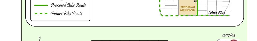
3 Agenda Item #: Manhattan Avenue - Manhattan Beach Blvd. to 1 st St. Route Highland Avenue - Citywide Route Rosecrans Avenue - Strand to Aviation Blvd. Route/Lane Marine Avenue - Sepulveda Blvd. to Aviation Blvd. Route/Lane (westbound) Pacific Avenue - Rosecrans Ave. to 5 th St./Ardmore Ave Route Redondo Avenue - Marine Ave. to Manhattan Beach Blvd. Route Peck Avenue - 2 nd St. to Artesia Blvd. Route 2 nd Street - Ardmore Ave. to Peck Ave. Route The Strand - Citywide Existing Path The following streets have been identified as potential future bike lanes in the Coastal Corridor Transportation Study conducted by the South Bay Council of Governments: Street Sepulveda Boulevard - Citywide Manhattan Beach Blvd. - Citywide Artesia Blvd. - Citywide Other Departments Comments The Traffic Engineer s suggested system was reviewed by a team comprised of staff members from the Police, Parks & Recreation and Public Works Departments. Comments received were as follows: - With the City being essentially built out, there are limits on what can be done in implementing bikeways. Realistically there are no places to add bike paths and few if any areas with room to designate striped lanes. Emphasis should be on identifying bike routes. - Safety must take precedent over enhancements to the transportation system. - Removing parking to accommodate bike facilities is not appropriate in Manhattan Beach. - The Public Works Department does not have any significant budget/maintenance concerns about installing signage for bike routes or limited striping & signage for bike lanes. - The Police Department is opposed to creating bike lanes on Sepulveda Blvd. or Manhattan Beach Blvd. because of safety concerns related to high traffic volumes. - The Police Department questions if Highland is an appropriate route because of its close proximity to The Strand bike path and high traffic/pedestrian activity. - There are no significant enforcement-related concerns, although some form of driver education would be useful if striped lanes are created. Page 3
4 Agenda Item #: - The Parks & Recreation Department feels the suggested system provides reasonable access to major recreational facilities. PPIC Review As stated previously the PPIC reviewed this issue at public meetings on October 28 and November 30, They are generally supportive of the proposed system, with several modifications. They feel few if any City streets are wide enough to accommodate marked lanes, so any initial City-wide system should include only bike routes. They are also opposed to designating Highland Avenue as a bike route because of its high pedestrian and traffic activity. They have similar concerns about Sepulveda and Manhattan Beach Boulevard but suggested these streets be considered as potential future routes in deference to the Coastal Corridor Study. They voted (3-0, Osterhout & Ackland absent) to recommend approval of an initial bikeway system as follows: Street Type Valley Drive Citywide Route Ardmore Avenue - Citywide Route Highland Avenue - Rosecrans to 45 th Street Future Route Manhattan Avenue - Manhattan Beach Blvd to 1 st Street Route Rosecrans Avenue - The Strand to Sepulveda Blvd Route Marine Avenue - Sepulveda Blvd to Aviation Blvd Route Marine Avenue - Pacific Avenue to Sepulveda Blvd Future Route Pacific Avenue - Rosecrans Ave to 5 th Street/Ardmore Ave Route Redondo Avenue - Marine Ave to Manhattan Beach Blvd Route Peck Avenue - 2 nd Street to Artesia Boulevard Route 2 nd Street - Ardmore Ave to Peck Ave Route Sepulveda Blvd Citywide Future Route Manhattan Beach Blvd Citywide Future Route Artesia Blvd. - Citywide Future Route This recommended system is illustrated in the attached map. The Traffic Engineer has no objection to the modifications made by the Commission. CONCLUSION: The bikeway systems suggested by the Traffic Engineer and the PPIC are strictly conceptual at this point. Should the Council decide to approve a system, staff would report back at a subsequent meeting with further analysis regarding issues such as alternatives for implementation, possibilities for obtaining grant funding and General Plan implications. The Los Angeles County Metropolitan Transportation Authority (MTA) and South Bay Cities Council of Governments (COG) are currently working to develop a county-wide bicycle Page 4
5 Agenda Item #: transportation strategic plan. Staff will work with these agencies to ensure that any system considered for Manhattan Beach is consistent with the county-wide plan. The next MTA/COG Plan workshop will be held in Torrance on January 13, Attachments: A. PPIC recommended bikeway system B. Excerpt from PPIC minutes of 11/30/04 C. PPIC report dated 11/30/04, with attachments Page 5


6
7 2. Citywide Bikeway System Traffic Engineer Erik Zandvliet presented the staff report, explaining that on October 28, 2004, the Commission reviewed the initial evaluation of some possible bikeways for adoption as a Citywide Bikeway System and directed staff to gather additional information from other departments and surrounding cities. Indicating that staff forwarded the evaluation to the cities of El Segundo, Redondo Beach, Hermosa Beach and Hawthorne, local schools, the school district, and all City departments, Traffic Engineer Zandvliet reviewed the comments obtained from these entities as well as the street segments being proposed for the Citywide Bikeway System. Commissioner Lesser commented that he would have liked to see more of an analysis done on school routes and how they relate to what is being proposed under the Bikeway System. Traffic Engineer Zandvliet verified that staff did forward the proposal to school representatives but the City did not receive back any comments, adding that staff s intent of the Bikeway System is to accommodate schools whenever possible. None. Audience Participation Discussion Commissioner Lang stated that the information compiled provides a tremendous piece of analysis on the City s street segments. He then spoke of his concerns with the proposed designation of bike routes/lanes on Highland Avenue, Manhattan Avenue, Rosecrans Avenue and Marine Avenue (west of Sepulveda), noting current traffic congestion and safety concerns. Commissioner Lang added that he would also be opposed to any future consideration of bike lanes on Manhattan Beach Boulevard, Artesia Boulevard and The Strand. Commenting that each member of the Commission may have different opinions on each street being proposed, Commissioner Lesser stated that he would like to see this proposal move forward to the City Council with the understanding that is represents a skeletal proposal of a concept that is supported by the Commission for consideration of grant funding. Chairman Saunders suggested that the Commission review each street segment to try to reach a consensus on moving the proposal forward to City Council. Chairman Saunders stated that he is concerned with the designation of bike lanes as they may interfere with traffic flow on collector streets and that he rather have just bike route designations. The Commission then discussed each suggested street segment. It was agreed upon that few if any City streets are wide enough for marked lanes, so the emphasis should be on routes. The Commission reached a consensus on an initial system as follows: 1
8 Valley Drive Bike Route Ardmore Avenue Bike Route Highland Avenue(Rosecrans to 45 th Street) Future Route Manhattan Avenue (Manhattan Beach Blvd to 1 st Street) Bike Route Rosecrans Avenue (The Strand to Sepulveda Blvd) Bike Route Marine Avenue (Sepulveda Blvd to Aviation Blvd) Bike Route Marine Avenue (Pacific Avenue to Sepulveda Blvd) Future Route Pacific Avenue (Rosecrans Ave to 5 th Street/Ardmore Ave) Bike Route Redondo Avenue (Marine Ave to Manhattan Beach Blvd) Bike Route Peck Avenue (2 nd Street to Artesia Boulevard) Bike Route 2 nd Street (Ardmore Ave to Peck Ave) Bike Route Sepulveda Blvd Citywide Future Route Manhattan Beach Blvd Citywide Future Route Artesia Blvd. - Citywide Future Route Action A motion was MADE and SECONDED (Lesser/Lang) to recommend approval of a bikeway system as outlined above. AYES: NOES: ABSENT: ABSTAIN: Lesser, Lang, Chairman Saunders None Ackland, Osterhout None 2
9 CITY OF MANHATTAN BEACH DEPARTMENT OF COMMUNITY DEVELOPMENT TO: FROM: BY: Parking and Public Improvements Commission Richard Thompson, Director of Community Development Robert D. Osborne, Management Analyst Erik Zandvliet, Traffic Engineer DATE: November 30, 2004 SUBJECT: Citywide Bikeway System BACKGROUND: The City Council s Annual Work Plan includes a task to determine if and where bikeways should be designated on the city s streets. On October 28, 2004, the Commission reviewed the initial evaluation of some possible bikeways for adoption as a Citywide Bikeway System and requested staff to gather additional information from other departments and surrounding cities. The initial evaluation was sent to the Cities of El Segundo, Redondo Beach, Hermosa Beach and Hawthorne for their comments. It was also sent to the local schools and school district, as well as all City departments. This report includes comments obtained by these entities. DISCUSSION: "Bikeway" means all facilities that provide primarily for bicycle travel. There are three types of bikeways: 1. Class I Bikeway (Bike Path). Provides a completely separated right of way for the exclusive use of bicycles and pedestrians with crossflow minimized. 2. Class II Bikeway (Bike Lane). Provides a striped lane for one-way bike travel on a street or highway. 3. Class III Bikeway (Bike Route). Provides for shared use with pedestrian or motor vehicle traffic with design criteria and uniform symbols. Bike Paths are preferred for greatest overall safety and efficiency, but off-street paths are difficult to achieve in built-out cities. Bike lanes provide generally safer riding conditions than Bike Routes, but require a dedicated area on the street. Class III Bike Routes require the least amount of right-of-way and have fewer design requirements. Construction costs can be as little as a few Bike Route signs up to tens of thousands of dollars to acquire land and build off-street Bike Paths. While designating Bikeways along routes with existing bike volumes is one method, it has also been found that Bikeways along new alignments will also encourage new or expanded bike use. 1
10 It is important that the Bikeways have connections and do not terminate without reaching a destination or another Bikeway so the bicyclist is not stranded in an area hostile to bicycles. Bikeway System Guidelines There are many factors to consider when determining if and what type of Bikeway is appropriate for a particular corridor. Among some of the more common parameters are: Existing or Projected Bicycle Volume Vehicular Volume Number of Vehicle Lanes Roadway width Curb Parking Regional and Local Destinations Recreational Venues Common Commuter Routes Collision History Surrounding Land Use Bicyclist Visibility Proximity to Roadway Hazards Location of existing Bikeways and bike facilities Due to the high cost of street reconstruction, candidate streets and areas should be wide enough to accommodate Bike Lanes or Bike Routes within the existing roadway. Commuter and recreational factors should be emphasized, so that the Bikeways serve the user. Since the City is essentially built-out, Bike Lanes and Bike Routes would be more appropriate and feasible than Bike Paths. The system should complement the existing and proposed Bikeways designated within the South Bay Region. For example, there is a planned bikeway for the unused Southern Pacific railroad right-of-way in El Segundo north of Rosecrans Avenue and east of Sepulveda Boulevard. Also, an existing Bike Path stretches along The Strand through Hermosa Beach, Manhattan Beach and El Segundo. The City of Redondo Beach has an existing Bikeway Plan. The City s General Plan includes several bicycle-oriented policies, including the following: Goal 6: Create well-marked pedestrian and bicycle networks that facilitate these modes of circulation. Policy I-6.6: Incorporate bikeways and pedestrian ways as part of the City s circulation system where safe and appropriate to do so. Policy I-6.7: Encourage features that accommodate the use of bicycles in the design of new development, as appropriate. Policy I-6.8: Encourage the development of Bikeways to link recreation areas and schools. The only Bikeway designated in the City s General Plan is The Strand Bikeway. Once a Citywide Bikeway Plan is adopted, several Grant programs become available for funding bicycle 2
11 projects. Often a Citywide Bikeway Plan or inclusion in a Countywide Bikeway Plan is a prerequisite for these funding programs. The California Supplement to the Manual of Uniform Traffic Control Devices has specific guidelines for the installation of Bike Lanes and Bike Paths. Bike Lane guidelines generally require a minimum width of four feet (4 ) where there is no curb parking and five feet (5 ) adjacent to curb parking. Bike Path guidelines require at least eight feet (8 ) for two-way bicycle movement. Bike Routes do not have specific minimum widths, but should only be designated after considering such bicycle sensitive factors such as surface condition, obstructions, curb parking, and connections to other Bikeways. Bicycle collisions were studied in a six-year period between January 1, 1995 and December 31, 2001 to identify any high collision locations. The majority of collisions occurred along proposed bikeways. The highest collision rate was on Manhattan Beach Boulevard between Highland Avenue and the Pier. A map is attached that identifies all bicycle collision locations. Staff compiled a list of 10 candidate streets that may be designated as Bikeways. Narrow and discontinuous streets were not considered. These locations are not prioritized and are only to be used as a starting point for creating a Citywide Bikeway System. A discussion of each street in no particular order is provided below. 1. Valley Drive Valley Drive is a two-lane residential collector street in a mixed commercial-residential area with a volume of 4,500 to 7,900 vehicles per day. It is a one-way street between 15 th Street and 1 st Street. The street is generally 32 feet wide with parking on one side. This street width would permit designation of a one-way Bike Route with two existing lanes and curb parking on one side, or two-way Bike Lanes with two existing lanes and no curb parking along its entire length. Most side streets are stopped along Valley Drive with one signalized and some stopped intersections. If used in conjunction with Ardmore Avenue, a one-way Bike Route couplet could be created to connect the southeast end of the proposed Bike Path in El Segundo with the beach and shopping destinations in Downtown. In the future it could possibly provide access under Sepulveda Boulevard to the Manhattan Village mall. Live Oak Park, the Civic Center, and Robinson Elementary School are also along this alignment. It could also provide a continuous Bikeway through the City into Hermosa Beach. If Bike Lanes are designated instead of Bike Route signs only, then southbound Ardmore Avenue/northbound Valley Drive markings are preferred due to significantly fewer cross streets to be negotiated by the bicyclist. As an alternate, a Bike Path could be designated within the Veterans Parkway in a meandering design or along either street. Due to topography changes, a Bike Path along either edge of the Parkway would be considerably more expensive than in the center, but there would be more pedestrian/bicycle conflicts with parallel Bike/Pedestrian facilities. Also, pedestrians may prefer to use the Bike Path instead of the unpaved pedestrian path for walking and running, which would decrease both bicyclist and pedestrian safety. 2. Ardmore Avenue 3
12 Ardmore Avenue is a two-lane residential collector street in a mixed commercial-residential area with a volume of 3,200 to 6,700 vehicles per day. It is a one-way street between 15th Street and 2 nd Street. The street is generally 30 feet wide with parking on one side. This street width would permit designation of a one-way Bike Route with two existing lanes and curb parking on one side, or two-way Bike Lanes with two existing lanes and no curb parking along its entire length. Most side streets are stopped along Ardmore Avenue with some signalized and stopped intersections. See Valley Drive for similar conditions. 3. Highland Avenue Highland Avenue is a two-lane collector street in a mixed commercial-residential area with a volume of 7,500 to 26,500 vehicles per day. The street is generally 39 feet wide with parking on both sides. It goes directly through Downtown. The street width would permit designation of a two-way Bike Route with two existing lanes and curb parking on both sides, or two-way Bike Lanes with two existing lanes and curb parking on one side along its entire length. Most side streets are stopped along Highland Avenue with some signalized and stopped intersections. This street would provide a parallel bikeway to The Strand in a north-south direction. It would link the downtown commercial area, civic center and North End commercial area with other recreational uses and bikeways. 4. Manhattan Avenue Manhattan Beach Boulevard to 1 st Street Manhattan Avenue is a two-lane collector street in a mixed commercial-residential area with a volume of 9,800 vehicles per day. The street is generally 50 feet wide with parking on both sides between Manhattan Beach Boulevard and 1 st Street. The street width would permit designation of a two-way Bike Lane with two existing lanes and curb parking on both sides south of the diagonal parking zone and a two-way Bike Route with two existing lanes and curb parking on both sides through the downtown. Most side streets are stopped along Manhattan Avenue along with some stopped intersections. This street would provide a parallel bikeway to The Strand in a north-south direction. It would link the downtown commercial area center with other recreational uses as well as Hermosa Beach to the south. 5. Rosecrans Avenue The Strand to Sepulveda Boulevard Rosecrans Avenue is a three to four-lane minor arterial street in a residential area with a volume of 17,500 to 20,000 vehicles per day. The street is generally 84 feet wide between Highland Avenue and Sepulveda Boulevard with a center left turn pocket/medians and parking on the south side. The street width would permit designation of a Bike Route on the south side and a Bike Lane on the north side with four existing through lanes and no curb parking on the north side within in the City of El Segundo. All side streets are stopped along Rosecrans Avenue along with the exception of three signalized intersections. This street would provide an eastwest bikeway through the north end of the City and connect the planned Bike Path along the RR easement in El Segundo to the beach in the west. It would link Sepulveda Boulevard with other business and recreational uses along the beach via Highland Avenue and The Strand. 6. Marine Avenue Sepulveda Boulevard to Aviation Boulevard 4
13 Marine Avenue is a four-lane minor arterial street in a mixed commercial-residential area with a volume of 20,500 vehicles per day. The street is generally 76 feet wide between Sepulveda Boulevard and Aviation Boulevard with a center left turn pocket/medians and parking on both sides. The street width would permit designation of a Bike Route on the south side and a Bike Lane on the north side with four existing through lanes and no curb parking adjacent to Manhattan Village. All side streets are stopped along Marine Avenue with the exception of five signalized intersections. This street would provide an east-west bikeway through most of the City. It would link Sepulveda Boulevard with other recreational uses such as Marine Avenue Park, AdventurePlex and the Youth Sports Complex. 7. Pacific Avenue Rosecrans Avenue to 5 th Street/Ardmore Avenue Pacific Avenue is a two-lane major local street in a residential area with a volume of 1,000 to 4,500 vehicles per day. The street is generally 38 to 40 feet wide between Rosecrans Avenue and 5 th Street/Ardmore Avenue with parking on both sides. The street width would permit designation of a two-way Bike Route with two through lanes and curb parking on both sides. Most side streets are stopped along Pacific Avenue except for some stopped intersections. This street would provide a north-south bikeway through the midportion of the City. It would link Rosecrans Avenue with other bicycle generators such as Pacific Elementary School and Valley/Ardmore to the south. 8. Redondo Avenue Marine Avenue to Manhattan Beach Boulevard Redondo Avenue is a two-lane major local street in a residential area with a volume of 3,000 to 4,000 vehicles per day. The street is generally 40 feet wide between Marine Avenue and Manhattan Beach Boulevard with parking on both sides. The street width would permit designation of a two-way Bike Route with two through lanes and curb parking on both sides. Most side streets are stopped along Pacific Avenue except for some stopped intersections. This street would provide a north-south bikeway through the easterly portion of the City. It would link the Marine Avenue Park and AdventurePlex with other bicycle generators such as Manhattan Middle School and Polliwog Park to the south. 9. Peck Avenue 2 nd Street to Artesia Boulevard Peck Avenue is a two-lane major local street in a residential area with a volume of 4,200 vehicles per day. The street is generally 42 feet wide between 2 nd Street and Artesia Boulevard with parking on both sides. The street width would permit designation of a two-way Bike Route with two through lanes and curb parking on both sides. Most side streets are stopped along Peck Avenue except for some stopped intersections. This street would provide a north-south bikeway through the easterly portion of the City. It would link several school sites including Mira Costa High School and Pennekamp Elementary School with beach destinations to the west via 2 nd Street nd Street Ardmore Avenue to Peck Avenue 5
14 2 nd Street is a two-lane major local street in a residential area with a volume of 3,000 to 4,000 vehicles per day. The street is generally 36 to 40 feet wide between Ardmore Avenue and Peck Avenue with parking on both sides. The street width would permit designation of a two-way Bike Route with two through lanes and curb parking on both sides. Most side streets are stopped along 2 nd Street except for some stopped intersections and a traffic signal at Sepulveda Boulevard. This street would provide an east-west bikeway to connect the southerly portion of the City. It would link several school sites including Mira Costa High School and Pennekamp Elementary School with beach destinations to the west via Peck Avenue. Planned Bikeways Sepulveda Boulevard, Manhattan Beach Boulevard and Artesia Boulevard While there is insufficient right-of-way to designate a continuous Bikeway on these streets at this time, these streets serve as major links to Bikeways and destinations in adjacent cities. Therefore, a planned Bike Route or Bike Lane could be designated on these streets for future implementation as development occurs. Manhattan Beach Boulevard has been identified as a long-term future Bike Lane in the Coastal Corridor Transportation Study conducted by the South Bay Council of Governments, of which Manhattan Beach is a part. Sepulveda Boulevard and Artesia Boulevard are identified in the City of Hermosa Local Bikeway Plan as proposed bike routes. COMMENTS FROM OTHER CITY DEPARTMENTS General thoughts With the City being more or less fully built out we re limited in what can be done. There are no places to add bike paths and few, if any, areas with room to designate striped lanes. Emphasis has to be on identifying bike routes. Safety must always take precedent over transportation enhancement. Removing parking to accommodate bike facilities may not be realistic in most areas. Public Works No significant budget/maintenance concerns about signage for bike routes or limited striping & signage for bike lanes. Police The Police Department is generally opposed to bike lanes on Sepulveda Boulevard. There are too many safety issues related to high traffic volume. Similar concerns about Manhattan Beach Blvd. They are not sure Highland is an appropriate route. This route would be in close proximity to the existing bike path and has high traffic & pedestrian activity. There are no significant enforcement-related concerns. Some driver education would be helpful if striped lanes are created. Parks & Recreation. The suggested system provides reasonable access to major recreational facilities. CONCLUSION: 6
15 Based on criteria analyzed on all candidate streets, staff feels a Citywide Bikeway System could be designated on the following street segments: STREET LIMITS TYPE Valley Drive Citywide Bike Route (SB) Ardmore Avenue Citywide Bike Route (NB) Highland Avenue Citywide Bike Route Manhattan Avenue Manhattan Beach Blvd. to 1 st St. Bike Route/Lane Rosecrans Avenue The Strand to Aviation Blvd. Bike Route/Lane (WB) Marine Avenue Sepulveda Blvd. to Aviation Blvd. Bike Route/Lane (WB) Pacific Avenue Rosecrans Ave. to 5 th St./Ardmore Ave. Bike Route Redondo Avenue Marine Ave. to Manhattan Beach Blvd. Bike Route Peck Avenue 2 nd St. to Artesia Blvd. Bike Route 2 nd Street Ardmore Ave. to Peck Ave. Bike Route Sepulveda Boulevard Citywide Future Bike Lane Manhattan Beach Boulevard Citywide Future Bike Lane Artesia Boulevard Citywide Future Bike Lane The Strand Citywide Existing Bike Path It is requested that the Commission review the material provided and provide input regarding the possibility of creating a bikeway system. The matter will ultimately be presented to the City Council for consideration. ATTACHMENTS State and Federal Guidelines (Excerpts) Draft Bikeway Plan Bicycle Collision History 2001 Long Range Transportation Plan (Metro) Bicycle Transportation Master Plan Update (Metro) Metro Bicycle Transportation Strategic Plan City Of Manhattan Beach General Plan (Excerpts) City Of Redondo Beach General Plan (Excerpts) City Of El Segundo General Plan (Excerpts) South Bay Cites Infrastructure and Services Capacity Assessment (Excerpts) Coastal Corridor Transportation Study (Excerpts) (SBCOG) C:\My Documents\Projects\JN Manhattan Beach TE\PPIC\PPIC-citywide bikeway plan.doc 7
16 STATE AND FEDERAL GUIDELINE EXCERPTS 8
17 MUTCD 2003 Section 9A.03 Definitions Relating to Bicycles Standard: The following terms shall be defined as follows when used in Part 9: 1. Bicycle Facilities a general term denoting improvements and provisions that accommodate or encourage bicycling, including parking and storage facilities, and shared roadways not specifically defined for bicycle use. 2. Bicycle Lane a portion of a roadway that has been designated by signs and pavement markings for preferential or exclusive use by bicyclists. 3. Bikeway a generic term for any road, street, path, or way that in some manner is specifically designated for bicycle travel, regardless of whether such facilities are designated for the exclusive use of bicycles or are to be shared with other transportation modes. 4. Designated Bicycle Route a system of bikeways designated by the jurisdiction having authority with appropriate directional and informational route signs, with or without specific bicycle route numbers. Bicycle routes, which might be a combination of various types of bikeways, should establish a continuous routing. 5. Shared-Use Path a bikeway outside the traveled way and physically separated from motorized vehicular traffic by an open space or barrier and either within the highway right-of-way or within an independent alignment. Shared-use paths are also used by pedestrians (including skaters, users of manual and motorized wheelchairs, and joggers) and other authorized motorized and non-motorized users. CALTRANS HIGHWAY DESIGN MANUAL Index Definitions "Bikeway" means all facilities that provide primarily for bicycle travel. (1) Class I Bikeway (Bike Path). Provides a completely separated right of way for the exclusive use of bicycles and pedestrians with crossflow minimized. (2) Class II Bikeway (Bike Lane). Provides a striped lane for one-way bike travel on a street or highway. (3) Class III Bikeway (Bike Route). Provides for shared use with pedestrian or motor vehicle traffic with design criteria and uniform symbols. MINIMUM STREET WIDTHS FOR BIKE LANES MINIMUM STREET WIDTH NO PARKING PARKING NOTES LANES PARKING 1 SIDE 2 SIDES 1 (ONE WAY) One way bike lane One-way bike lane Two-way bike lane 2+LEFT TURN One-way bike lane 2+LEFT TURN Two-way bike lane One-way bike lane Two-way bike lane 4+LEFT TURN Two-way bike lane 9
18 DRAFT BIKEWAY PLAN 10
19 BICYCLE COLLISION HISTORY 11
20 2001 LONG RANGE TRANSPORTATION PLAN (Excerpts) (METRO) 12
21 BICYCLE TRANSPORTATION MASTER PLAN UPDATE (METRO) 13
22 METRO BICYCLE TRANSPORTATION STRATEGIC PLAN 14
23 CITY OF MANHATTAN BEACH GENERAL PLAN (EXCERPTS) 15
24 CITY OF REDONDO BEACH GENERAL PLAN (EXCERPTS) 16
25 CITY OF EL SEGUNDO GENERAL PLAN (EXCERPTS) 17
26 SOUTH BAY CITES INFRASTRUCTURE AND SERVICES CAPACITY ASSESSMENT June 30,
27 COASTAL CORRIDOR TRANSPORTATION STUDY (EXCERPTS) (SBCOG) 19
Staff Report City of Manhattan Beach
 Agenda Item #: Staff Report City of Manhattan Beach TO: THROUGH: FROM: Honorable Mayor Fahey and Members of the City Council Geoff Dolan, City Manager Richard Thompson, Director of Community Development
Circulation in Elk Grove includes: Motor vehicles, including cars and trucks
 Circulation, as it is used in this General Plan, refers to the many ways people and goods move from place to place in Elk Grove and the region. Circulation in Elk Grove includes: Motor vehicles, including
Beach Cities Living Streets Design Manual and Aviation Boulevard Multimodal Corridor Plan
 Beach Cities Living Streets Design Manual and Aviation Boulevard Multimodal Corridor Plan AGENDA 1 Introductions & Project Scope 2 Public Outreach Recap 3 Living Streets Design Manual 4 Aviation Boulevard
Solana Beach Comprehensive Active Transportation Strategy (CATS)
") Solana Beach Comprehensive Active Transportation Strategy (CATS) 3.0 Goals & Policies The Solana Beach CATS goals and objectives outlined below were largely drawn from the Solana Beach Circulation Element
Solana Beach Comprehensive Active Transportation Strategy (CATS) 3.0 Goals & Policies The Solana Beach CATS goals and objectives outlined below were largely drawn from the Solana Beach Circulation Element
CITY OF LOMITA CITY COUNCIL REPORT
 CITY OF LOMITA CITY COUNCIL REPORT TO: FROM: City Council Ryan Smoot, City Manager Item No. SCH 12 PREPARED BY: Mark A. McAvoy, P.E., Public Works Director/City Engineer MEETING DATE: August 1, 2017 SUBJECT:
Corpus Christi Metropolitan Transportation Plan Fiscal Year Introduction:
 Introduction: The Safe, Accountable, Flexible, Efficient Transportation Equity Act: A Legacy for Users (SAFETEA-LU) has continued the efforts started through the Intermodal Surface Transportation Efficiency
CITY OF SIGNAL HILL Cherry Avenue Signal Hill, CA
 CITY OF SIGNAL HILL 2175 Cherry Avenue Signal Hill, CA 90755-3799 AGENDA ITEM TO: HONORABLE MAYOR AND MEMBERS OF THE CITY COUNCIL FROM: STEVE MYRTER, P. E. DIRECTOR OF PUBLIC WORKS SUBJECT: SPRING STREET
4. ENVIRONMENTAL IMPACT ANALYSIS 9. TRANSPORTATION AND TRAFFIC
 4. ENVIRONMENTAL IMPACT ANALYSIS 9. TRANSPORTATION AND TRAFFIC 4.9.1 INTRODUCTION The following section addresses the Proposed Project s impact on transportation and traffic based on the Traffic Study
TRAFFIC ACTION PLAN. Laurie Meadows Neighborhood CITY OF SAN MATEO
 TRAFFIC ACTION PLAN Laurie Meadows Neighborhood CITY OF SAN MATEO Draft January 2017 Table of Contents Introduction... 2 The Traffic Forum Process... 5 Neighborhood Traffic Issues... 7 Neighborhood Recommendations
Madison Urban Area and Dane County. Bicycle Transportation Plan Summary. September Introduction. Bicycle Plan Scope and Planning Process
 Bicycle Transportation Plan Summary Madison Urban Area and Dane County Introduction September 2000 Bicycling is an important mode of transportation in the Madison urban area and countywide that is available
CONNECTING PEOPLE TO PLACES
 CONNECTING PEOPLE TO PLACES 82 EAST BENCH MASTER PLAN 07 Introduction The East Bench transportation system is a collection of slow moving, treelined residential streets and major arteries that are the
FEDERAL HIGHWAY ADMINISTRATION APPLICATION
 FEDERAL HIGHWAY ADMINISTRATION APPLICATION REQUEST FOR PERMISSION TO EXPERIMENT WITH A BICYCLE BOX INTERSECTION TREATMENT Submitted by: City of Columbus Department of Public Service Date: June 26, 2009
NM-POLICY 1: Improve service levels, participation, and options for non-motorized transportation modes throughout the County.
 Transportation PRINCE WILLIAM COUNTY 2008 COMPREHENSIVE PLAN NON-MOTORIZED PLAN CONTENTS Goals, Policies, and Action Strategies Table 4 (Bike Facility Classifications and Descriptions) Table 5 (Bike Facility
WELCOME. Thank you for joining us at the Second Public Workshop for the Carlsbad Pedestrian Master Plan. We look forward to receiving your feedback.
 City of Carlsbad Pedestrian Master Plan: WELCOME WELCOME Please Sign In Provide Input at Flip Charts Review Boards Presentation of Draft Plan Thank you for joining us at the Second Public Workshop for
DEPARTMENT OF ENVIRONMENTAL SERVICES. North Harrison Street (Lee Highway to Little Falls Road) Comparative Analysis. Prepared for:
 Comparative Analysis. Prepared for:") DEPARTMENT OF ENVIRONMENTAL SERVICES North Harrison Street (Lee Highway to Little Falls Road) Comparative Analysis Prepared for: Arlington County Department of Environmental Services 2100 Clarendon Boulevard,
DEPARTMENT OF ENVIRONMENTAL SERVICES North Harrison Street (Lee Highway to Little Falls Road) Comparative Analysis Prepared for: Arlington County Department of Environmental Services 2100 Clarendon Boulevard,
Item 08M 1 of 9
 MEETING DATE: December 20, 2017 PREPARED BY: Christopher L. Magdosku, City Engineer DEPT DIRECTOR: Brenda Wisneski DEPARTMENT: Development Services CITY MANAGER: Karen P. Brust SUBJECT: Interim North Coast
Toronto and East York Community Council. Director, Transportation Services, Toronto and East York District
 No Turn on Red Regulations STAFF REPORT ACTION REQUIRED Date: June 1, 2010 To: From: Toronto and East York Community Council Director, Transportation Services, Toronto and East York District Wards: Trinity
Non-Motorized Transportation 7-1
 Non-Motorized Transportation 7-1 Transportation facilities no longer mean just accommodating a vehicle powered by a combustion engine. Pedestrian and non-motorized facilities are important modes of travel
Double the amount of bicycle ridership while at the same time reducing the number of bicycle crashes by one-third.
 CHAPTER 6 Recommended Policies and Action Items To achieve the goals stated in Chapter 1 and guide implementation of the Bicycle Plan, policies and action items have been identified. They are presented
Exhibit 1 PLANNING COMMISSION AGENDA ITEM
 Exhibit 1 PLANNING COMMISSION AGENDA ITEM Project Name: Grand Junction Circulation Plan Grand Junction Complete Streets Policy Applicant: City of Grand Junction Representative: David Thornton Address:
TRANSPORTATION COMMISSION Agenda Staff Report
 TRANSPORTATION COMMISSION Agenda Staff Report Agenda Item No. 5.a DATE: JULY 31, 2014 TO: FROM: SUBJECT: TRANSPORTATION COMMISSION COMMUNITY DEVELOPMENT DEPARTMENT - PLANNING DRAFT OLYMPIC CORRIDOR PREFERRED
CITY OF ELKO BICYCLE AND PATHWAY PLAN
 CITY OF ELKO BICYCLE AND PATHWAY PLAN INTRODUCTION: The City of Elko is intended to provide the basic framework for the development of a functional bicycle and pathway system for the community with connections
CITY OF COCOA BEACH 2025 COMPREHENSIVE PLAN. Section VIII Mobility Element Goals, Objectives, and Policies
 CITY OF COCOA BEACH 2025 COMPREHENSIVE PLAN Section VIII Mobility Element Goals, Objectives, and Policies Adopted August 6, 2015 by Ordinance No. 1591 VIII MOBILITY ELEMENT Table of Contents Page Number
Transportation Development Act Grant Center Avenue Pedestrian Signal Project
 CITY OF MARTINEZ CITY COUNCIL AGENDA April 15, 2015 TO: FROM: SUBJECT: DATE: Mayor and City Council Tim Tucker, City Engineer Transportation Development Act Grant Center Avenue Pedestrian Signal Project
Bicycle Master Plan Goals, Strategies, and Policies
 Bicycle Master Plan Goals, Strategies, and Policies Mobilizing 5 This chapter outlines the overarching goals, action statements, and action items Long Beach will take in order to achieve its vision of
Caltrans Sloat Boulevard Pedestrian Safety Project Response to Community Questions, Comments & Concerns
 Caltrans Sloat Boulevard Pedestrian Safety Project Response to Community Questions, Comments & Concerns Revised: May 10, 2016 The California Department of Transportation (Caltrans) is planning various
Bikeway action plan. Bicycle Friendly Community Workshop March 5, 2007 Rochester, MN
 Bikeway action plan Summary The was held on March 5, 2007 at the Rochester Mayo Civic Center. The workshop was hosted by Rochester-Olmsted County Planning Department in collaboration with the League of
Item No. 14 Town of Atherton
 Item No. 14 Town of Atherton CITY COUNCIL STAFF REPORT CONSENT AGENDA TO: THROUGH: FROM: HONORABLE MAYOR AND CITY COUNCIL GEORGE RODERICKS, CITY MANAGER MICHAEL KASHIWAGI, COMMUNITY SERVICES DIRECTOR MARTY
Summary: Mercer County Princeton Avenue & Spruce Street Study January 2009
 Summary: Several recent studies have assessed potential development and redevelopment opportunities in the Mercer Crossing area of Trenton, Ewing, and Lawrence. This Princeton Avenue and Spruce Street
Agenda. Overview PRINCE GEORGE S PLAZA METRO AREA PEDESTRIAN PLAN
 PRINCE GEORGE S PLAZA METRO AREA PEDESTRIAN PLAN May 28, 2008 Agenda Welcome and introductions Project overview and issue identification Planning context and strengths Design challenges and initial recommendations
Clackamas County Comprehensive Plan
 ROADWAYS The County s road system permits the movement of goods and people between communities and regions, using any of a variety of modes of travel. Roads provide access to virtually all property. They
SOLANA BEACH BICYCLE TRANSPORTATION PLAN SECOND ADDENDUM
 SOLANA BEACH BICYCLE TRANSPORTATION PLAN SECOND ADDENDUM Prepared by the City of Solana Beach January 2005 Introduction In June of 1993, the Solana Beach City Council adopted a Bikeway Master Plan as directed
South Bay Bicycle Master Plan American Planning Association National Conference Los Angeles, CA
 South Bay Bicycle Master Plan 2012 American Planning Association National Conference Los Angeles, CA April 17, 2012 Overview I. Background II. The Importance of Partnerships III. Approach and Success Stories
SANTA MONICA BOULEVARD CORRIDOR
 CIRCULATION ELEMENT WHITE PAPER NO. 3 SANTA MONICA BOULEVARD CORRIDOR INTRODUCTION From the 1930s to the beginning of Los Angeles freeway era, Santa Monica Boulevard, (previously Route 66, the Beverly
5. RUNNINGWAY GUIDELINES
 5. RUNNINGWAY GUIDELINES These guidelines should be considered collectively when making runningway decisions. A runningway is the linear component of the transit system that forms the right-of-way reserved
o n - m o t o r i z e d transportation is an overlooked element that can greatly enhance the overall quality of life for the community s residents.
 N o n - m o t o r i z e d transportation is an overlooked element that can greatly enhance the overall quality of life for the community s residents. 84 Transportation CHAPTER 11 INTRODUCTION Transportation
4.11 Transportation and Traffic
 4.11.1 Introduction This section evaluates whether implementation of the Russian River Estuary Management Project (Estuary Management Project) would result in potential adverse impacts related to transportation
10A. DATE: October 5, Pedestrian and Bicycle Advisory Committee. Kevin Colin, Deputy Planning Manager Curt Bates, City Engineer
 10A DATE: October 5, 2016 TO: PREPARED BY: SUBJECT: Pedestrian and Bicycle Advisory Committee Kevin Colin, Deputy Planning Manager Curt Bates, City Engineer Discussion and Provide Comments, Associated
PRINCE GEORGE S PLAZA METRO AREA PEDESTRIAN PLAN
 PRINCE GEORGE S PLAZA METRO AREA PEDESTRIAN PLAN May 28, 2008 Agenda Welcome and introductions Project overview and issue identification Planning context and strengths Design challenges and initial recommendations
Chapter 3 DESIGN SPECIFICATIONS
 Brampton PathWays Planning and Design Guidelines 27 Chapter 3 DESIGN SPECIFICATIONS 3.1 CLASS 1 MULTI-USE PATH Off-road multi-use trails are the backbone of the Brampton PathWays Network. They are typically
Transportation Development Act Grant Radar Check Speed Signs
 City Council Agenda January 18, 2017 To: From: Subject: Mayor and City Council Tim Tucker, City Engineer Transportation Development Act Grant Radar Check Speed Signs Date: January 10, 2017 Recommendation
City of Gainesville Transportation/Roadway Needs PROJECT SUMMARY
 A1 Roadway Resurfacing $23,846,000 TYPE: Preservation of existing system Roadway resurfacing A2 Signal Replacement $6,000,000 TYPE: Preservation of existing system Replace traffic signals. B1 W 6th St
5 CIRCULATION AND STREET DESIGN
 5 CIRCULATION AND STREET DESIGN This chapter describes circulation and streetscape improvements proposed for the Northwest Chico Specific Plan Area. It includes detailed design specifications for existing
AGENDA ITEM G-2 Public Works
 AGENDA ITEM G-2 Public Works STAFF REPORT City Council Meeting Date: 12/6/2016 Staff Report Number: 16-214-CC Regular Business: Approve the Oak Grove University Crane Bike Improvement Concept Plan, authorize
Third Street Bridge & Corridor Project
 Third Street Bridge & Corridor Project Preparation for the FY2018 budget to commence October 1, 2017, includes funding to address a project that has been considered since 1994. The Third Street bridge
Active Transportation Facility Glossary
 Active Transportation Facility Glossary This document defines different active transportation facilities and suggests appropriate corridor types. Click on a facility type to jump to its definition. Bike
Improving Cyclist Safety at the Dundas Street West and Sterling Road Intersection
 STAFF REPORT ACTION REQUIRED Improving Cyclist Safety at the Dundas Street West and Sterling Road Intersection Date: August 17, 2012 To: From: Wards: Reference Number: Public Works and Infrastructure Committee
CITY MANUALS AND STANDARDS REVIEW
 GEORGETOWN SIDEWALK MASTER PLAN CITY MANUALS AND STANDARDS REVIEW RESOURCES AND STANDARDS As part of the Master Plan process, a review and evaluation of current City documents and policies relevant to
REGIONAL BICYCLE AND PEDESTRIAN DESIGN GUIDELINES
 REGIONAL BICYCLE AND PEDESTRIAN DESIGN GUIDELINES November 16, 2011 Deb Humphreys North Central Texas Council of Governments Bicycle and Pedestrian Advisory Committee Snapshot of the Guide 1. Introduction
This page intentionally left blank.
 This page intentionally left blank. COMMUNITY Glenpool Community Overview Glenpool Glenpool is a city of nearly 12,000 residents located in Tulsa County southwest of Tulsa and Jenks. The city is growing
PEDESTRIAN ACTION PLAN
 ATTACHMENT 2 CITY OF SANTA MONICA PEDESTRIAN ACTION PLAN CITY OF SANTA MONICA PEDESTRIAN ACTION PLAN This page intentionally left blank EXECUTIVE SUMMARY CHAPTER 1 EXECUTIVE SUMMARY Setting the Stage
Cycle Track Design Best Practices Cycle Track Sections
 Design Best Practices Sections It is along street segments where the separation and protection methods of cycle tracks offer more comfort than conventional bicycle lanes, and are more attractive to a wide
TABLE OF CONTENTS. Executive Summary
 Executive Summary Background... ES-1 Pedestrian Network... ES-2 Bikeway Network... ES-2 Collision History... ES-2 Public Input... ES-4 Conclusions and Recommendations... ES-4 1. Introduction and Setting
Chapter 2: Standards for Access, Non-Motorized, and Transit
 Standards for Access, Non-Motorized, and Transit Chapter 2: Standards for Access, Non-Motorized, and Transit The Washtenaw County Access Management Plan was developed based on the analysis of existing
HARRISON STREET/OAKLAND AVENUE COMMUNITY TRANSPORTATION PLAN
 HARRISON STREET/OAKLAND AVENUE Community Workshop #4: Draft Plan Review December 3, 2009 D E S I G N, C O M M U N I T Y & E N V I R O N M E N T INTRODUCTIONS Key Project Staff: Alisa Shen, Project Manager,
2014/2015 BIKE ROUTE PLAN 83 AVENUE PROTECTED BIKE LANE
 About the Project 2014/2015 BIKE ROUTE PLAN The City of Edmonton is planning a major bike route on the south side of Edmonton. This bike route is one part of a plan to provide citizens with transportation
REPORT TO FRESNO COUNCIL OF GOVERNMENTS STEVE BRANDT, QUAD KNOPF ASSISTANT PROJECT MANAGER THROUGH: LAUREN DAWSON, FRESNO COG PROJECT MANAGER
 REPORT TO FRESNO COUNCIL OF GOVERNMENTS DATE: APRIL 2012 TO: FROM: FRESNO COG POLICY BOARD STEVE BRANDT, QUAD KNOPF ASSISTANT PROJECT MANAGER THROUGH: LAUREN DAWSON, FRESNO COG PROJECT MANAGER SUBJECT:
MASTER BICYCLE AND PEDESTRIAN PLAN
 VILLAGE OF NORTHBROOK MASTER BICYCLE AND PEDESTRIAN PLAN DRAFT PLAN OPEN HOUSE May 2, 2018 AGENDA 1. Community Engagement 2. Vision and Goals 3. General Structure of Plan 4. Recommendations Overview 5.
This page intentionally left blank.
 This page intentionally left blank. COMMUNITY Coweta Community Overview Coweta Coweta, a residential community located in Wagoner County, is a suburb of Tulsa situated southeast of the metropolitan area
WHEREAS, the New Jersey Department of Transportation' s Complete Streets
 WHEREAS, the State Department of Transportation adopted a Complete Streets Policy ( Policy No. 703), effective December 3, 2009, for all projects funded through the Department' s Capital Program and strongly
REVIEW OF LOCAL TRAFFIC FLOW / LONG RANGE PLANNING SOLUTIONS STUDY
 ITEM Town of Atherton TRANSPORTATION COMMITTEE STAFF REPORT TO: FROM: MEMBERS OF THE COMMITTEE ROBERT OVADIA, PUBLIC WORKS DIRECTOR DATE: FEBRUARY 12, 2019 SUBJECT: REVIEW OF LOCAL TRAFFIC FLOW / LONG
Tonight is for you. Learn everything you can. Share all your ideas.
 Strathcona Neighbourhood Renewal Draft Concept Design Tonight is for you. Learn everything you can. Share all your ideas. What is Neighbourhood Renewal? Creating a design with you for your neighbourhood.
TRAFFIC IMPACT ANALYSIS
 TRAFFIC IMPACT ANALYSIS FOR THE CHAMPAIGN UNIT#4 SCHOOL DISTRICT PROPOSED HIGH SCHOOL (SPALDING PARK SITE) IN THE CITY OF CHAMPAIGN Final Report Champaign Urbana Urbanized Area Transportation Study 6/24/2014
City of Novi Non-Motorized Master Plan 2011 Executive Summary
 City of Novi Non-Motorized Master Plan 2011 Executive Summary Prepared by: February 28, 2011 Why Plan? Encouraging healthy, active lifestyles through pathway and sidewalk connectivity has been a focus
Glebe Neighbourhood Cycling Plan
 Glebe Neighbourhood Cycling Plan Summary of Public Comments received after June 5 th Public Information Session Comment STUDY NETWORK CS9, CS8, E, E0 CS4, E CS4 CS8 E Suggestions for alternate cycling
Chapter 7. Transportation. Transportation Road Network Plan Transit Cyclists Pedestrians Multi-Use and Equestrian Trails
 Chapter 7 Transportation Transportation Road Network Plan Transit Cyclists Pedestrians Multi-Use and Equestrian Trails 7.1 TRANSPORTATION BACKGROUND The District of Maple Ridge faces a number of unique
Chapter VISION, MISSION, AND GOALS AND OBJECTIVES. Vision. Mission. Goals and Objectives CONNECTING COMMUNITIES ACROSS THE ST.
 VISION, MISSION, AND GOALS AND OBJECTIVES Chapter 3 The Plan s vision, mission, and goals and objectives were developed through a series of interactive exercises with the Citizens Advisory Committee (CAC)
TRAFFIC ACTION PLAN. North Central Neighborhood CITY OF SAN MATEO
 TRAFFIC ACTION PLAN North Central Neighborhood CITY OF SAN MATEO Draft February 2017 Table of Contents Introduction... 1 The Traffic Forum Process... 4 Neighborhood Traffic Issues... 6 Neighborhood Recommendations
Perryville TOD and Greenway Plan
 Perryville TOD and Greenway Plan Greenway Glossary Pathway: A bicycle and pedestrian path separated from motorized vehicular traffic by an open space, barrier or curb. Multi-use paths may be within the
TRAFFIC CALMING POLICY & PROCEDURES
 TRAFFIC CALMING POLICY & PROCEDURES AS ADOPTED BY MONTCLAIR TOWNSHIP COUNCIL AUGUST 4, 2009 TABLE OF CONTENTS 1. INTRODUCTION... 2 Purpose... 2 Traffic Calming Definition... 2 Statement Of Township Council
ACTIVE TRANSPORTATION
 ACTIVE TRANSPORTATION Mobility 2040 Supported Goals Improve the availability of transportation options for people and goods. Support travel efficiency measures and system enhancements targeted at congestion
Omaha s Complete Streets Policy
 Omaha s Complete Streets Policy (Adopted August 2015) VISION To create great places and enhance our quality of life, the City of Omaha will provide safe, accessible streets for all users. Complete Streets
DRAFT - CITY OF MEDFORD TRANSPORTATION SYSTEM PLAN Roadway Cross-Sections
 Roadway Cross-Sections Medford s roadway cross-section standards apply to new and reconstructed roads. The crosssections take into consideration roadway function and operational characteristics, including
Donahue Drive Corridor Traffic Operational Evaluation
 Donahue Drive Corridor Traffic Operational Evaluation PREPARED FOR: THE CITY OF AUBURN PREPARED BY: JANUARY 2007 Donahue Drive Corridor Study--Auburn, Alabama TABLE OF CONTENTS Introduction... 1 Background
Albany Shaker Road Corridor Study Public Meeting # 2
 Albany Shaker Road Corridor Study Public Meeting # 2 Scope / Meeting Purpose This project is a CDTC Linkage Study. The Linkage Program is designed to implement the adopted planning and investment principles
CITY OF BLOOMINGTON COMPLETE STREETS POLICY
 CITY OF BLOOMINGTON COMPLETE STREETS POLICY POLICY OBJECTIVE: The City of Bloomington will enhance safety, mobility, accessibility and convenience for transportation network users of all ages and abilities,
INTRODUCTION THOROUGHFARE SYSTEM CLASSIFICATIONS
 INTRODUCTION The thoroughfare plan will assist public officials in the development of a specialized system for efficient and safe movement of vehicular traffic while minimizing potential conflicts with
General Plan Circulation Element Update Scoping Meeting April 16, 2014 Santa Ana Senior Center, 424 W. 3rd Street, Santa Ana, CA 92701
 General Plan Circulation Element Update Scoping Meeting April 16, 2014 Santa Ana Senior Center, 424 W. 3rd Street, Santa Ana, CA 92701 Meeting Agenda 1. Purpose of Scoping Meeting 2. Project Overview 3.
1 st and 2 nd Street Couplet FAQ s
 1 st and 2 nd Street Couplet FAQ s Q. Will the proposed roundabout at Flume/2nd/1 st Streets affect access to businesses nearby?... 2 Q. What if the project isn t received well by the community after construction?...
Mineral Avenue Corridor Assessment. ITE 2017 Western District Annual Meeting San Diego, CA June 21 st
 Mineral Avenue Corridor Assessment ITE 2017 Western District Annual Meeting San Diego, CA June 21 st Biography - Aaron Heumann, PE, PTOE Currently City of Littleton Transportation Engineering Manager 24
West Dimond Blvd Upgrade Jodhpur Street to Sand Lake Road
 West Dimond Blvd Jodhpur St to Sand Lake CSS Transportation Project Summary Municipality of Anchorage Project # 05 005 Project Manager: John Smith, P.E. (MOA PM&E) Project Administrator: Julie Makela,
Anne Arundel County BICYCLE, PEDESTRIAN, TRANSIT ASSESSMENT GUIDELINES
 Anne Arundel County BICYCLE, PEDESTRIAN, TRANSIT ASSESSMENT GUIDELINES December 2018 TABLE OF CONTENTS I. Executive Summary 3 II. When Is A Bicycle Pedestrian Transit Assessment (BPTA) Required? 4 III.
Welcome! San Jose Avenue Open House August 25, 2015
 Welcome! San Jose Avenue Open House August 25, 2015 Vision Zero The City and County of San Francisco adopted Vision Zero San Francisco Vision Zero High Injury Network as a policy in 2014, committing an
Chapter 2. Bellingham Bicycle Master Plan Chapter 2: Policies and Actions
 Chapter 2 Bellingham Bicycle Master Plan Chapter 2: Policies and Actions Chapter 2: Policies and Actions The Bicycle Master Plan provides a road map for making bicycling in Bellingham a viable transportation
TRAFFIC CALMING GUIDE FOR TORONTO CITY OF TORONTO TRANSPORTATION SERVICES DIVISION
 TRAFFIC CALMING GUIDE FOR TORONTO CITY OF TORONTO TRANSPORTATION SERVICES DIVISION CITY OF TORONTO TRANSPORTATION SERVICES DIVISION 2016 TRAFFIC CALMING GUIDE FOR TORONTO TABLE OF CONTENTS Introduction
General Design Factors
 Chapter 3: 3-1.0 Introduction General Design Factors Mn/DOT s goals include encouraging and accommodating safe bicycling. From a design perspective, these goals are achieved by first having an understanding
BUDGET FOR RESEDA BOULEVARD, STREET RECONSTRUCTION / VISION ZERO PROGRAM, REPORT BACK, COUNCIL FILE
 FORM GEN. 160 (Rev. 11-02) CITY OF LOS ANGELES INTERDEPARTMENTAL CORRESPONDENCE Date: To: Honorable City Council From: Gary Lee Moore, City Engineer Bureau of Engineering 7%mt /Electronically signed by
C C C
 C-012-001 Thank you for your support for the creation of new public space and nonmotorized access between downtown and the waterfront through the Overlook Walk, the East-West Connections, and the Promenade.
INDOT Complete Streets Guideline & Policy
 INDOT Complete Streets Guideline & Policy INTRODUCTION The Complete Streets guidelines build upon multiple efforts and promote a multimodal transportation system that is integrated and sustains land use
1. What is the Doran Street and Broadway/Brazil Grade Separation Project (Project)?
?") 1. What is the Doran Street and Broadway/Brazil Grade Separation Project (Project)? The Los Angeles County Metropolitan Transportation Authority (Metro) is evaluating the development of a grade separation
1. What is the Doran Street and Broadway/Brazil Grade Separation Project (Project)? The Los Angeles County Metropolitan Transportation Authority (Metro) is evaluating the development of a grade separation
APPROVE A RESOLUTION ADOPTING A COMPLETE STREETS POLICY
 STAFF REPORT MEETING DATE: September 13, 2016 TO: FROM: City Council Bob Brown, Community Development Director Russ Thompson, Public Works Director Patrick Filipelli, Management Analyst 922 Machin Avenue
TOWN OF CHAPEL HILL POLICY AND PROCEDURES FOR TRAFFIC CALMING MEASURES
 TOWN OF CHAPEL HILL POLICY AND PROCEDURES FOR TRAFFIC CALMING MEASURES (Adopted by the Town Council on June 30, 2004) (Revised December 6, 2010) (Revised February 8, 2016) POLICY AND PROCEDURES FOR TRAFFIC
City of Memphis On-Street Parking Modification Guidelines
 City of Memphis Effective Date: December 1, 2013 Bicycle/Pedestrian Program 125 N. Main Street Memphis, TN 38103 (901) 576-6710 www.bikepedmemphis.com City of Memphis Executive Summary It is current practice
SAN FRANCISCO MUNICIPAL TRANSPORTATION AGENCY
 THIS PRINT COVERS CALENDAR ITEM NO. : 10.3 DIVISION: Sustainable Streets Division BRIEF DESCRIPTION: SAN FRANCISCO MUNICIPAL TRANSPORTATION AGENCY Approving traffic and parking modifications to install
Safe Streets. City of Lake Forest Park. March 21, 2017
 Safe Streets City of Lake Forest Park March 21, 2017 1 01 WELCOME 2 Agenda WELCOME WHAT IS THIS PROJECT? CONTEXT DRAFT CITYWIDE PROJECTS EXERCISE INTRODUCTION 3 02 WHAT IS THIS PROJECT? 4 WHAT IS THIS
Draft MOBILITY ELEMENET. Community Meeting May 22, 2013
 Draft MOBILITY ELEMENET Community Meeting May 22, 2013 Agenda Presentation Ira Brown New Mobility Paradigm Movement of People Implementation Q&A Ira Brown and Dave Roseman Small Group Discussion at Each
Recommendations. Central Salem Mobility Study
 Central Salem Mobility Study The Central Salem Mobility Study evaluated a range of multimodal transportation issues affecting downtown Salem, including circulation, access, and safety for people traveling
2.0 LANE WIDTHS GUIDELINE
 2.0 LANE WIDTHS GUIDELINE Road Engineering Design Guidelines Version 2.0.1 May 2018 City of Toronto, Transportation Services City of Toronto Page 0 Background In early 2014, Transportation Services initiated
2. NORTEL CARLING CAMPUS EXPANSION - PROPOSED MODIFICATIONS TO MOODIE DRIVE (REGIONAL ROAD 59) AND HIGHWAY 417 INTERCHANGE
 AND HIGHWAY 417 INTERCHANGE") 2. NORTEL CARLING CAMPUS EXPANSION - PROPOSED MODIFICATIONS TO MOODIE DRIVE (REGIONAL ROAD 59) AND HIGHWAY 417 INTERCHANGE COMMITTEE RECOMMENDATIONS AS AMENDED That Council approve: 1. The endorsement
2. NORTEL CARLING CAMPUS EXPANSION - PROPOSED MODIFICATIONS TO MOODIE DRIVE (REGIONAL ROAD 59) AND HIGHWAY 417 INTERCHANGE COMMITTEE RECOMMENDATIONS AS AMENDED That Council approve: 1. The endorsement
WEDNESDAY, SEPTEMBER 6, :00 PM City Council Chambers, 1 Civic Center Drive, San Marcos, CA 92069
 MINUTES Meeting of the San Marcos Traffic Commission WEDNESDAY, SEPTEMBER 6, 2017 6:00 PM City Council Chambers, 1 Civic Center Drive, San Marcos, CA 92069 CALL TO ORDER: Vice Chairman Rico called the