CONTRACT C1039: N2/BORCHERDS QUARRY INTERCHANGE AND RELATED WORKS SARF SEMINAR 11 AUGUST 2016
|
|
|
- Marylou Hudson
- 5 years ago
- Views:
Transcription


1 CONTRACT C1039: N2/BORCHERDS QUARRY INTERCHANGE AND RELATED WORKS SARF SEMINAR 11 AUGUST 2016

2 Current Spatial Pattern - MSDF
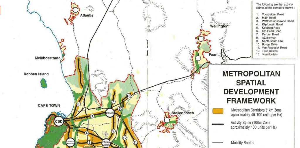
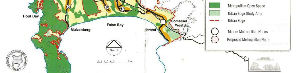
3 MSDF


4 City Of Cape Town CTOD
5 City Of Cape Town CTOD
6 Project Planning Objectives Understand the medium to long term land-use and transport infrastructure scenarios for the study area. Improve N2 access to Philippi Industria. Improve N2 access to CTIA and adjacent industrial areas (Airport Industria, Airport City) Improve public transport access on: Proposed IRT corridor along Eisleben/Lansdowne/New Borcherds Quarry. Extend N2: 3rd lane/bmt lane from Borcherds Quarry Interchange to Mew Way Interchange. Allow in the infrastructure planning for Airport Beltway Expressway improvements. Support a consistent road network/hierarchy in the study area.


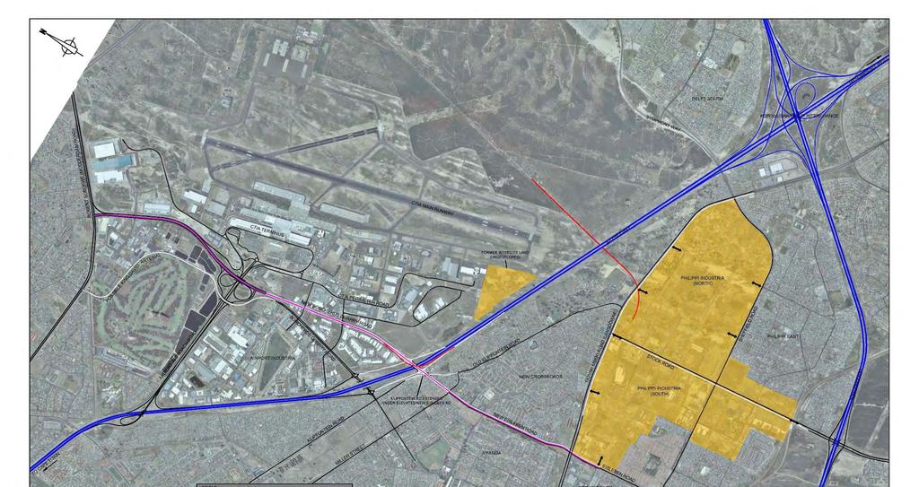
7 Philippi Freeway Accessibility Existing Situation DELFT SOUTH N2/R300 SWARTKLIP INTERCHANGE AIRPORT INDUSTRIA PHILIPPI INDUSTRIA (NORTH) PHILIPPI EAST NEW CROSSROADS PHILIPPI INDUSTRIA (SOUTH) NYANGA PHOLA PARK ROUTE 1 R300 access from North and N2 access from East ROUTE 2 R300 access from West ROUTE 3 N2 access from West BROWNS FARM

8 Borcherds Quarry Road

9 Eisleben Drive


10 PREVIOUS ROAD/INTERCHANGE LAYOUTS New Borcherds Quarry Alignment Airport Industria CTIA Perimeter Road King David Golf Course Development
11 Alternative Interchange Layouts
12 Minimum Ramp Spacing Requirements RECOMMENDED MINIMUM RAMP TERMINAL SPACING (SANRAL) Table 7.1 Interchange Spacing in terms of Signage Requirements Interchange Configuration Ramp access to access Ramp access to system interchange System interchange to ramp access System interchange to system interchange Minimum ramp spacing in urban areas 1300m 2100m 1400m 2500m
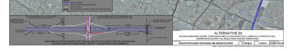
13 3 Signalised intersections (200m spacing) (sub-standard spacing; 540m required) N2/R300 SWARTKLIP INTERCHANGE Exit ramp to Symphony Way off new extended C-D road leading to N2/R300 eastbound ramp. 300m between merges Meets AASHTO minimum spacing. TO CAPE TOWN ALTERNATIVE A-1 N2 half diamond interchange onto Symphony Way. Indirect N2 access into Philippi Industria via Sheffield Road. LEGEND Freeways New Arterial/Service/Access Roads Existing Arterial/Service/Access Roads MyCiti Busway Lanes Traffic Signals
14 TO SOMERSET WEST NEW CROSSROADS TO CAPE TOWN ALTERNATIVE A-2 N2 partial trumpet interchange with west facing ramps only, direct N2 access onto extended Stock Road. LEGEND Freeways New Arterial/Service/Access Roads Existing Arterial/Service/Access Roads MyCiti Busway Lanes Traffic Signals
15 TO SOMERSET WEST INTERSITE LAND NEW CROSSROADS TO CAPE TOWN ALTERNATIVE A-3 Full trumpet interchange with direct N2 access onto extended Stock Road. LEGEND Freeways New Arterial/Service/Access Roads Existing Arterial/Service/Access Roads MyCiti Busway Lanes Traffic Signals
16 TO SOMERSET WEST Requires CTIA perimeter fence to be set back additional 10-20m NEW CROSSROADS TO CAPE TOWN ALTERNATIVE A-4 Full diamond interchange with direct N2 access onto Stock Road extension. LEGEND Freeways New Arterial/Service/Access Roads Existing Arterial/Service/Access Roads MyCiti Busway Lanes Traffic Signals
17 TO SOMERSET WEST TO CAPE TOWN ALTERNATIVE B-1 Minimum infrastructure intervention. Retain existing Borcherds Quarry (BQ) Road Interchange, build extension of New Eisleben Drive over N2 into New Borcherds Quarry (NBQ) with no access to N2. Option to add east facing ramps on NBQ for Airport Precinct. LEGEND Freeways New Arterial/Service/Access Roads Existing Arterial/Service/Access Roads MyCiti Busway Lanes Traffic Signals
18 TO SOMERSET WEST ` TO CAPE TOWN ALTERNATIVE B-2 Combine existing BQ and NBQ Interchanges as a split Diamond Interchange on N2, option to add east facing ramps on NBQ for Airport Precinct. LEGEND Freeways New Arterial/Service/Access Roads Existing Arterial/Service/Access Roads MyCiti Busway Lanes Traffic Signals
19 TO SOMERSET WEST TO CAPE TOWN ALTERNATIVE B-3 Combine existing BQ and NBQ Interchanges as a double (B type) Parclo Interchanges with a 500m weave length on N2 between merging and diverging ramps. LEGEND Freeways New Arterial/Service/Access Roads Existing Arterial/Service/Access Roads MyCiti Busway Lanes Traffic Signals
20 TO SOMERSET WEST ` Note: C-D roads in fill for overpass structure over existing Borcherds Quarry Road TO CAPE TOWN ALTERNATIVE B-4 Combine existing BQ and NBQ Interchanges with C-D road arrangement with partial single point diamond arrangement for major N2/Eisleben Drive/NBQ turn movements. LEGEND Freeways New Arterial/Service/Access Roads Existing Arterial/Service/Access Roads MyCiti Busway Lanes Traffic Signals
21 TO SOMERSET WEST ` ` Note: C-D roads in fill for overpass structure over existing Borcherds Quarry Road TO CAPE TOWN ALTERNATIVE B-5A New single point diamond interchange on NBQ with only west facing ramps retained at existing BQ interchange. Proposed C-D roads linking two sets of west facing ramps. LEGEND Freeways New Arterial/Service/Access Roads Existing Arterial/Service/Access Roads MyCiti Busway Lanes Traffic Signals
22 TO SOMERSET WEST ` TO CAPE TOWN ALTERNATIVE B-5B New single point diamond interchange on NBQ with only west facing ramps retained at existing BQ Interchange. No C-D roads proposed. LEGEND Freeways New Arterial/Service/Access Roads Existing Arterial/Service/Access Roads MyCiti Busway Lanes Traffic Signals
23 TO SOMERSET WEST Note: C-D roads in fill for overpass structure over existing Borcherds Quarry Road TO CAPE TOWN ALTERNATIVE B-6A New diamond interchange on NBQ with only west facing ramps retained at existing BQ Interchange. Proposed C-D roads linking two sets of west facing ramps. LEGEND Freeways New Arterial/Service/Access Roads Existing Arterial/Service/Access Roads MyCiti Busway Lanes Traffic Signals
24 TO SOMERSET WEST TO CAPE TOWN ALTERNATIVE B-6B New diamond interchange on NBQ with only west facing ramps retained at existing BQ Interchange. No C-D roads proposed. LEGEND Freeways New Arterial/Service/Access Roads Existing Arterial/Service/Access Roads MyCiti Busway Lanes Traffic Signals


25 TO SOMERSET WEST TO CAPE TOWN ALTERNATIVE B-6C New diamond interchange on NBQ with no west facing ramps retained at existing BQ Interchange. No C-D roads proposed. LEGEND Freeways New Arterial/Service/Access Roads Existing Arterial/Service/Access Roads MyCiti Busway Lanes Traffic Signals

26 Alternative Interchange Layouts
27
28
29
30
31
32
33
34
35 Summary of Successive Ramp Spacings on N2 Freeway Distance Between Successive Ramps Along N2 Freeway EB (To Somerset West) WB (To Cape Town) Design Spacing Minimum Spacing (SANRAL) Design Spacing Minimum Spacing (SANRAL) Alternative 3a Alternative 8 Airport Approach NBQ 1555m 1300m R300 NBQ 1895m 1400m NBQ R m 2100m Airport Approach EBQ NBQ Airport Approach 2105m 1300m 830m 1300m R300 NBQ 1895m 1400m EBQ NBQ 830m 1300m NBQ EBQ 1045m 1300m NBQ R m 2100m EBQ Airport Approach 1045m 1300m
36 Nett Total Cost R mil Nett Total Cost R mil (excl. VAT); (incl. Contingency and Contractor P&G) N2 CORRIDOR (PGWC) Interchange Upgrades Additional 3rd lane on N2 to km 17.5 Subtotal ROAD NETWORK (CoCT) km Mew Way SANRAL Nett Total Cost (excl. VAT) Alternative 1 R R R R R R R R R R R R A R R R R R R B R R R R R R * 5 7 R R R R R R R R R R R R R R R R R R R R R R R R *Measurement Includes C-D Roads and Realignment of the N2
37 Multi Criteria Evaluation PROPOSED EVALUATION CRITERIA FOR INTERCHANGE / ROAD NETWORK ALTERNATIVES Proposed Rating Description Rating Excellent 5 Above average 4 Average 3 Below average 2 Poor 1
38 Multi Criteria Evaluation: Summary of Findings: Weighting Summary Evaluation Criteria HHO AFRICA (ORIGINAL WEIGHTING) CoCT IRT Planning CoCT Spatial Planning HHO AFRICA (EQUAL WEIGHTING) Construction Cost Cost of roads, bridges, services, property acquisition, etc Interchange Planning / Road Network Considerations Network Traffic Performance PT Services / NMT Network Improved Access and Security Risk to Implementation Interchange/C-D ramps: spacing requirements Road hierarchy Intersection spacing Travel time savings and level of service IRT/ Public transport services NMT routes across N Philippi Industrial & surrounds CTIA, Airport precincts, etc Potential delays due to housing relocation and land acquisition Total
39 Multi Criteria Evaluation: Summary of Findings: Score Summary Weighting Alternative 1 2 3a 3b 4c HHO AFRICA (ORIGINAL WEIGHTING) CoCT IRT Planning CoCT Spatial Planning HHO AFRICA (EQUAL WEIGHTING) TOTAL
40 Preferred Alternative
41 Land Use Projections & Traffic Modelling CoCT Pragmatic Densification Scenario (PDS) for 2032 as based Modelled scenario uses PDS as base, plus : CTIA generated traffic (25 MPA) PEDI "optimistic scenario" (105ha) Portion of Glebe land (76 ha; 70% of 108ha) 1% pa background peak hour traffic growth
42 Future Flows on Alternative 03A Network : AM Peak Hour
43 Future Flows on Alternative 03A Network : PM Peak Hour

44 Borcherds Quarry Road Robert Sobukwe to Airport Approach

45 New Borcherds Quarry Road Airport Approach to N2


46 New Borcherds Quarry Road/N2 Interchange

47 New Eisleben Drive N2 to Govan Mbeki
48 Project Planning Objectives In conclusion we have met the following objectives: Understood the medium to long term land-use and transport infrastructure scenarios for the study area. Improved N2 access to Philippi Industria and its linkage to the Airport & Airport Industrial Area. Improved N2 access to CTIA and adjacent industrial areas (Airport Industria, Airport City) Improved public transport access on: Proposed IRT corridor along Eisleben/New Borcherds Quarry, with links to Klipfontein & Wetton-Lansdowne Road Corridors Extend N2: 3rd lane/bmt lane from Borcherds Quarry Interchange to Mew Way Interchange. NMT infrastructure along the route Improved NMT accessibility across the N2 Allowed in the infrastructure planning for Airport Beltway Expressway improvements. Supported a consistent road network/hierarchy in the study area. Paving the way towards the City s vision of a node at Philippi
49 Way Forward Phase 1: 3 rd lane on N2 underway Remaining Phases: Scheduled for 2018/19 Finalise detailed design Relocation of Steenbras water main Relocation of informal housing within road prism
Transport Impact Assessment
 Transport Impact Assessment King David Golf Course Redevelopment Airport Industria Cape Town October 2017 5th Floor Imperial Terraces Carl Cronje Drive Tyger Waterfront Bellville, 7530 INNOVATIVE TRANSPORT
Chapter 4 Traffic Analysis
 Chapter 4 Traffic Analysis PURPOSE The traffic analysis component of the K-68 Corridor Management Plan incorporates information on the existing transportation network, such as traffic volumes and intersection
I-264 CORRIDOR EVALUATION STUDY. September 7, 2016 Eric Stringfield VDOT Planning Director Chris Lawrence AECOM Senior Transportation Engineer
 I-264 CORRIDOR EVALUATION STUDY September 7, 2016 Eric Stringfield VDOT Planning Director Chris Lawrence AECOM Senior Transportation Engineer Study Overview Interchange Locations Study Context Follow-up
List of Display Boards
 List of Display Boards Welcome Introduction Municipal Class Environmental Assessment (EA) Process Need and Justification for an Interchange Alternatives for Evaluation Vertical and Horizontal Alignments
INTERSTATE 540 IMPROVEMENT STUDY
 INTERSTATE 540 IMPROVEMENT STUDY WASHINGTON COUNTY AND BENTON COUNTY APRIL, 2006 INTERSTATE 540 IMPROVEMENT STUDY WASHINGTON COUNTY AND BENTON COUNTY April, 2006 Prepared by Parsons Transportation Group
Subject: Solberg Avenue / I-229 Grade Separation: Traffic Analysis
 MEMORANDUM Transportation Bill Troe, AICP Jason Carbee, AICP 12120 Shamrock Plaza Suite 300 Omaha, NE 68154 (402) 334-8181 (402) 334-1984 (Fax) To: Project File Date: Subject: Solberg Avenue / I-229 Grade
Design Criteria. Design Criteria
 F Design Criteria Design Criteria Ministry of Transportation Ministère des Transports DESIGN CRITERIA Page: 1 of 13 WORK PROJECT NO. N/A GO Bloomington Station TYPE OF PROJECT LOCATION Bloomington Road
Appendix 9.A - Interchanges Figure 9-A-1 Four-leg Interchanges between Expressways
 374 The Guidelines for Road Design Appendix 9.A - Interchanges Figure 9-A-1 Four-leg Interchanges between Expressways 375 The Guidelines for Road Design Figure 9-A-2 Three-leg Interchanges between Expressways
Southwest Bus Rapid Transit (SW BRT) Functional Planning Study - Executive Summary January 19 LPT ATTACHMENT 2.
 Functional Planning Study - Executive Summary January 19 LPT ATTACHMENT 2.") Southwest Bus Rapid Transit (SW BRT) Functional Planning Study - Executive Summary 2011 January 19 1 of 19 Introduction This executive summary presents the results of the Southwest Bus Rapid Transit (SW
Southwest Bus Rapid Transit (SW BRT) Functional Planning Study - Executive Summary 2011 January 19 1 of 19 Introduction This executive summary presents the results of the Southwest Bus Rapid Transit (SW
DUNBOW ROAD FUNCTIONAL PLANNING
 DUNBOW ROAD FUNCTIONAL PLANNING Final Report August 3, 216 #31, 316 5th Avenue NE Calgary, AB T2A 6K4 Phone: 43.273.91 Fax: 43.273.344 wattconsultinggroup.com Dunbow Road Functional Planning Final Report
Interstate Route 77 / US Route 62 / State Route 687 (Fulton Road) Transportation Improvement Project. Prepared September 6, 2017
 Transportation Improvement Project. Prepared September 6, 2017") EODOT Project: ODOT Project: STA-IR 77-.50; PID 00290 Interstate Route 77 / US Route 62 / State Route 687 (Fulton Road) Transportation Improvement Project Summary of Public Comments Received and Responses
EODOT Project: ODOT Project: STA-IR 77-.50; PID 00290 Interstate Route 77 / US Route 62 / State Route 687 (Fulton Road) Transportation Improvement Project Summary of Public Comments Received and Responses
I-215 / NEWPORT ROAD INTERCHANGE PROJECT PRESS KIT
 I-215 / NEWPORT ROAD INTERCHANGE PROJECT PRESS KIT March I-215 / NEWPORT ROAD INTERCHANGE PROJECT Fact Sheet Project Overview This project will reconstruct the existing interchange located on Interstate
CHAPTER 3 STUDY AREA OPERATIONAL OVERVIEW
 HPTER 3 STUY RE OPERTIONL OVERVIEW This chapter describes the overall traffic operations within the study area under existing and future conditions and focuses on individual intersections not directly
I-20 ODESSA-MIDLAND CORRIDOR STUDY. Public Meeting for Schematic Design
 I-20 ODESSA-MIDLAND CORRIDOR STUDY Public Meeting for Schematic Design The environmental review, consultation, and other actions required by applicable Federal environmental laws for this project are being,
I-95 NORTHBOUND AT US 1 (EXIT 126) ALTERNATIVES DESIGN ANALYSIS
 ALTERNATIVES DESIGN ANALYSIS") FAMPO Policy Committee Briefing June 18, 2018 I-95 NORTHBOUND AT US 1 (EXIT 126) ALTERNATIVES DESIGN ANALYSIS WHAT IS THE STARS PROGRAM? Program to develop solutions to reduce crashes and congestion bottlenecks
FAMPO Policy Committee Briefing June 18, 2018 I-95 NORTHBOUND AT US 1 (EXIT 126) ALTERNATIVES DESIGN ANALYSIS WHAT IS THE STARS PROGRAM? Program to develop solutions to reduce crashes and congestion bottlenecks
Harrah s Station Square Casino
 Transportation Analysis Harrah s Station Square Casino Pittsburgh, Pennsylvania Submitted To: City of Pittsburgh and Pennsylvania Gaming Control Board Prepared By: DKS Associates GAI Consultants December
Iowa Highway 58 Corridor Improvement Study
 1 Iowa Highway 58 Corridor Improvement Study Public Informational Meeting May 6, 2014 2 Welcome and Introductions Randy Lorenzen, City of Cedar Falls Engineer 3 Outline of Presentation Review of Project
CHIEF PEGUIS TRAIL EXTENSION WEST
 1 PRELIMINARY DESIGN OF THE CHIEF PEGUIS TRAIL EXTENSION WEST Public Information Session June 6, 2017 Welcome 1 Thank you for attending today s public information session. The following boards provide
Simons Run Corridor Study
 Simons Run Corridor Study Campbell County & City of Lynchburg, Virginia Prepared on: September 30, 2014 Prepared for: Central Virginia Metropolitan Planning Organization 277 Bendix Road, Suite 500 Virginia
Terwillegar Drive Expressway Draft Concept Plan
 Terwillegar Drive Expressway Draft Concept Plan Anthony Henday Drive to Whitemud Drive November 28 5:00-8:00 p.m. December 1 10:00 a.m. - 3:00 p.m. Let s Talk Today you can: Learn about the new direction
Route 7 (East Market Street) Interchange at Battlefield Parkway Town of Leesburg Project No: UPC Presentation to Town Council
 Interchange at Battlefield Parkway Town of Leesburg Project No: UPC Presentation to Town Council") Route 7 (East Market Street) Interchange at Battlefield Parkway Town of Leesburg Project No: 0007-253-109 UPC 106573 Presentation to Town Council June 26, 2017 Council Decisions East Market Street / Battlefield
Route 7 (East Market Street) Interchange at Battlefield Parkway Town of Leesburg Project No: 0007-253-109 UPC 106573 Presentation to Town Council June 26, 2017 Council Decisions East Market Street / Battlefield
Capital Region Council of Governments
 March 23, 2018 Capital Region Council of Governments PROJECT CONCEPT REPORT Realignment of Swamp and Northfield Road s approaches to Route 44 (Boston Turnpike) Town of Coventry SUMMARY: The Town of Coventry
Casablanca Boulevard & GO Station Access
 Casablanca Boulevard & GO Station Access Class Environmental Assessment STAKEHOLDER WORKSHOP Thursday September 27th, 2018 5:30PM 8:00PM 1 WORKSHOP PURPOSE Provide an overview of the Design Alternatives
Los Altos Hills Town Council - June 18, 2015 Palo Alto City Council June 22, AGENDA ITEM #2.B Presentation
 Los Altos Hills Town Council - June 18, 2015 Palo Alto City Council June 22, 2015 AGENDA ITEM #2.B Presentation Previous Presentations Los Altos Hills Town Council in May 2014 and February 2015 Palo Alto
BUS RAPID TRANSIT. A Canadian Perspective. McCormick Rankin International. John Bonsall P.Eng
 BUS RAPID TRANSIT A Canadian Perspective Why choose BRT? Because it is a practical and cost effective rapid transit solution for the most common types of land use in urban Canada Operating experience shows
MoPac South: Impact on Cesar Chavez Street and the Downtown Network
 MoPac South: Impact on Cesar Chavez Street and the Downtown Network Prepared by: The University of Texas at Austin Center for Transportation Research Prepared for: Central Texas Regional Mobility Authority
Grade Separated Intersection
 Grade Separated Intersection Lecture Notes in Transportation Systems Engineering Prof. Tom V. Mathew Contents 1 Overview 1 2 Classification of Intersection 2 2.1 Grade Separated Intersection...........................
Report Purpose To seek Council s approval of the Wye Road Functional Planning Study (January 2015).
.") COUNCIL MEETING Meeting Date: March 10, 2015 Agenda Item #: 13.1 Wye Road Functional Planning Study (January 2015) Report Purpose To seek Council s approval of the Wye Road Functional Planning Study (January
COUNCIL MEETING Meeting Date: March 10, 2015 Agenda Item #: 13.1 Wye Road Functional Planning Study (January 2015) Report Purpose To seek Council s approval of the Wye Road Functional Planning Study (January
Let s Make I-40 Better Action Team. Friday, March 29, 2019 Hosted by RTP Foundation
 Let s Make I-40 Better Action Team Friday, March 29, 2019 Hosted by RTP Foundation RTA Welcome Geoff Lang, MetLife, RTA Chair Jim Beley, The Umstead Hotel & Spa, RTA regional travel experience chair NCDOT
WELCOME PTH 59N - PTH 101 INTERCHANGE FUNCTIONAL DESIGN STUDY PUBLIC INFORMATION SESSION MONDAY, JUNE 13, :00 P.M. - 8:00 P.M.
 WELCOME - PTH 1 INTERCHANGE FUNCTIONAL DESIGN STUDY PUBLIC INFORMATION SESSION MONDAY, JUNE 13, 11 4:00 P.M. - 8:00 P.M. PROJECT STUDY AREA 1 Wenzel Street PR 2 Pritchard Farm Farm Road Road McGregor Farm
Freeway System Considerations
 Session 11 Jack Broz, PE, HR Green May 5-7, 2010 Freeway System Considerations Mainline Transit: Shoulder Operations, BRT, Stations HOV, HOT, UPA Interchanges Exit Ramps Entrance Ramps Bridges Local Crossings
Traffic Impact Statement. Durbanville Development Erf 40, Re 72, Erf and Erf 91, Durbanville
 Traffic Impact Statement Durbanville Development Erf 40, Re 72, Erf 5732 and Erf 9, Durbanville PREPARED FOR: CONTACT PERSON: Gerhard Nel e-mail: gnel@jubelie.co.za PREPARED BY: KERNEELS LION CACHET ENGINEERS
Northwest Corridor Project Interchange Modification, Interchange Justification and System Analysis Report Reassessment (Phase I)
") Northwest Corridor Project Interchange Modification, Interchange Justification and System Analysis Report Reassessment (Phase I) Introduction The Georgia Department of Transportation (GDOT) prepared a
Northwest Corridor Project Interchange Modification, Interchange Justification and System Analysis Report Reassessment (Phase I) Introduction The Georgia Department of Transportation (GDOT) prepared a
Transportation Committee Project Priority List
 Transportation Committee Project Priority List Funded Priorities PRIORITY 1 - Interstate 81, Exit 310 Improvements Description: Construct improvements to Exit 310 interchange. Capital Cost: $54,200,000
444 North Capitol Street NW, Suite 249, Washington, DC (202) Fax: (202) ERRATA
 Fax: (202) ERRATA") Larry L. Butch Brown, Sr., President Executive Director, Mississippi Department of Transportation John Horsley, Executive Director 444 North Capitol Street NW, Suite 249, Washington, DC 20001 (202) 624-5800
Larry L. Butch Brown, Sr., President Executive Director, Mississippi Department of Transportation John Horsley, Executive Director 444 North Capitol Street NW, Suite 249, Washington, DC 20001 (202) 624-5800
Operational & Geometrical Analysis Technical Memorandum
 I-395 Southbound between Duke Street & Edsall Road: Congestion Relief Feasibility Study Operational & Geometrical Analysis Technical Memorandum Task Order #92 Prepared by: July 17, 2012 Rummel, Klepper
Highway 49, Highway 351 and Highway 91 Improvements Feasibility Study Craighead County
 Highway 49, Highway 351 and Highway 91 Improvements Feasibility Study Craighead County Executive Summary March 2015 Highway 49, Highway 351 and Highway 91 Improvements Feasibility Study Craighead County
Alberta Infrastructure HIGHWAY GEOMETRIC DESIGN GUIDE AUGUST 1999
 Alberta Infrastructure HIGHWAY GEOMETRIC DESIGN GUIDE AUGUST 1999,1'(; A ACCELERATION Data on acceleration from stop D-29 Effects of grade D-35 Intersections D-97, D-99 Lanes D-97, F-5, F-7, F-15, F-21,
METHODOLOGY. Signalized Intersection Average Control Delay (sec/veh)
") Chapter 5 Traffic Analysis 5.1 SUMMARY US /West 6 th Street assumes a unique role in the Lawrence Douglas County transportation system. This principal arterial street currently conveys commuter traffic
Chapter 5 Traffic Analysis 5.1 SUMMARY US /West 6 th Street assumes a unique role in the Lawrence Douglas County transportation system. This principal arterial street currently conveys commuter traffic
RIGHT TURNS AT INTERSECTIONS: ARE THERE ALTERNATIVES?
 RIGHT TURNS AT INTERSECTIONS: ARE THERE ALTERNATIVES? R.C. Pyke, J.D. Sampson and K.G. Schmid Stewart Scott International, P O Box 784506, Sandton, 2146 TTT Africa, P.O.Box 109, Sunninghill, G.D.P.T.R.W,
VDOT I-66 Inside the Beltway Eastbound Widening Environmental Assessment. Staff Recommendations
 VDOT I-66 Inside the Beltway Eastbound Widening Environmental Assessment Staff Recommendations Department of Environmental Services Transportation January 28, 2017 Timeline of Transform66 June 2012: I-66
Project Description Form 6V
 Project Description Form 6V Basic Project Information Submitting Jurisdiction/Agency: Prince William County Project Title: Route 15 Widening: Route 55 to south of RR tracks & Construct RR Overpass Project
Queensboro Bridge Bus Priority Study: Summary of Recommendations. Presentation to Manhattan Community Board 8 May 4, 2011
 : Summary of Recommendations Presentation to Manhattan Community Board 8 May 4, 2011 1 Overview Study Goal: Identify cost-effective ways to improve bus speed and reliability for local and express buses
County of Fairfax, Virginia. Department of Transportation
 Fairfax County Parkway History 2 Planning began 50 years ago 1960s Washington s Regional Transportation Plan Recommends improved north/south travel Construct Capital Beltway and outer beltway Outer beltway
72 Avenue Four Laning (BNSF Overpass to 120 Street) WELCOME. Public Information Meeting
 WELCOME. Public Information Meeting") 72 Avenue Four Laning (BNSF Overpass to 120 Street) WELCOME Public Information Meeting Project Goals About the Project The goal of this project is to address congestion along 72 Avenue and adjacent streets
72 Avenue Four Laning (BNSF Overpass to 120 Street) WELCOME Public Information Meeting Project Goals About the Project The goal of this project is to address congestion along 72 Avenue and adjacent streets
Hospital Link Project Project Update September 2017
 Hospital Link Project Project Update September 2017 General The project provides a link from Riverside Drive and the Transitway to the Hospital Link Road. Construction is well underway. Read on for important
5858 N COLLEGE, LLC N College Avenue Traffic Impact Study
 5858 N COLLEGE, LLC nue Traffic Impact Study August 22, 2016 Contents Traffic Impact Study Page Preparer Qualifications... 1 Introduction... 2 Existing Roadway Conditions... 5 Existing Traffic Conditions...
CITY OF SPOKANE VALLEY Request for Council Action
 CITY OF SPOKANE VALLEY Request for Council Action Meeting Date: December 16, 2014 Department Director Approval: Check all that apply: consent old business new business public hearing information admin.
Chapter 33. Grade Separated Intersection Overview Classification of Intersection Grade Separated Intersection
 Chapter 33 Grade Separated Intersection 33.1 Overview An intersection is the area shared by the joining or crossing of two or more roads. Since the main function of an intersection is to enable the road
Journey to Excellence. Building Markham s Future Together MARCH 24, 2015 HIGHWAY 407 TO HIGHWAY 7 MAIN STREET MARKHAM
 MAIN STREET MARKHAM HIGHWAY 407 TO HIGHWAY 7 1 MARCH 24, 2015 2 DISCUSSION Update Committee on Project Schedule Reversible Lanes Recommendations Next Steps 3 COMPLETED WORK 4 PROJECT UPDATE Enbridge is
Feasibility Study of Pedestrian Crossings Along Route 7, East of Cascades Parkway and West of Dranesville Road. October 3, 2017
 Feasibility Study of Pedestrian Crossings Along Route 7, East of Cascades Parkway and West of Dranesville Road October 3, 2017 Study Area (area within a ¼-mile radius of the study intersections) Route
SECTION 12 ROAD MARKINGS AND DELINEATION
 SECTION 12 20 June 2009 Part 3: Motorways and Expressways CONTENTS Reference Page Page Number Date SECTION 12: MARKINGS AND DELINEATION 12.1 GENERAL... 12-1 June 2009 12.1.1 INTRODUCTION... 12-1 June 2009
ENHANCED PARKWAY STUDY: PHASE 2 CONTINUOUS FLOW INTERSECTIONS. Final Report
 Preparedby: ENHANCED PARKWAY STUDY: PHASE 2 CONTINUOUS FLOW INTERSECTIONS Final Report Prepared for Maricopa County Department of Transportation Prepared by TABLE OF CONTENTS Page EXECUTIVE SUMMARY ES-1
Appendix D: Concept Screening
 Concept Description Concept #1 Route 288 Roadway Widening This concept consists of constructing a third lane on northbound and southbound Route 288 between Powhite Parkway and US 360. This improvement
WEST AND SOUTH WEST RING ROAD DOWNSTREAM TRAFFIC IMPACTS
 Page 1 of 9 EXECUTIVE SUMMARY Alberta Transportation ( AT ) is preparing to construct the final sections of the Calgary Ring Road. This includes the South West Ring Road ( SWRR ) (from Lott Creek Blvd
SAMRAND DEVELOPMENT (PTY) LTD C2562/01TIA FEBRUARY 2019
 LTD C2562/01TIA FEBRUARY 2019") SAMRAND DEVELOPMENT (PTY) LTD C2562/1TIA PROPOSED MIXED-USE DEVELOPMENT TO BE LOCATED ON ERVEN 1 AND 2, KOSMOSDAL EXTENSION 14 CENTURION, PRETORIA TRAFFIC IMPACT ASSESSMENT FEBRUARY 219 REPORT SHEET PROJECT
SAMRAND DEVELOPMENT (PTY) LTD C2562/1TIA PROPOSED MIXED-USE DEVELOPMENT TO BE LOCATED ON ERVEN 1 AND 2, KOSMOSDAL EXTENSION 14 CENTURION, PRETORIA TRAFFIC IMPACT ASSESSMENT FEBRUARY 219 REPORT SHEET PROJECT
Gwinnett County Department of Transportation SR 324 / Gravel Springs Road at I-85 / SR 403 Interchange Project Number F , PI No.
 June 4, 2015 Dear Resident: Thank you for attending this public information meeting for the proposed SR 324 / Gravel Springs Road at I-85 Interchange. The purpose of this meeting is two-fold: to provide
Diverging Diamond Interchange and Double Crossover Intersection Vehicle and Pedestrian Performance
 Diverging Diamond Interchange and Double Crossover Intersection Vehicle and Pedestrian Performance Praveen K. Edara, Department of Civil and Environmental Engineering, Virginia Polytechnic Institute and
PAEKĀKĀRIKI HILL ROAD / BEACH ROAD / SH1 INTERSECTION PROGRESS REPORT
 Chairperson and Committee Members ENVIRONMENT AND COMMUNITY DEVELOPMENT COMMITTEE 6 DECEMBER 2011 Meeting Status: Public Purpose of Report: For Decision PAEKĀKĀRIKI HILL ROAD / BEACH ROAD / SH1 INTERSECTION
WYDOT DESIGN GUIDES. Guide for. NHS Arterial (Non-Interstate)
") WYDOT DESIGN GUIDES Guide for NHS Arterial (Non-Interstate) 2014 GUIDE FOR NATIONAL HIGHWAY SYSTEM (NHS) HIGHWAYS (NHS ARTERIALS, Non-Interstate) PRESERVATION REHABILITATION RECONSTRUCTION INTRODUCTION
WYDOT DESIGN GUIDES Guide for NHS Arterial (Non-Interstate) 2014 GUIDE FOR NATIONAL HIGHWAY SYSTEM (NHS) HIGHWAYS (NHS ARTERIALS, Non-Interstate) PRESERVATION REHABILITATION RECONSTRUCTION INTRODUCTION
TECHNICAL MEMORANDUM
 TECHNICAL MEMORANDUM DATE: January 17, 2005 TO: Ted Idlof, URS FROM: Jeff Clark, Fehr & Peers RE: U.S. 50 Interchange Planning Study 1042-2011 This memorandum describes conceptual improvements for the
ACCESS MANAGEMENT PLAN: BLUFFTON PARKWAY BLUFFTON PARKWAY: PHASE FOUR TOWN OF BLUFFTON & BEAUFORT COUNTY, SC
 ACCESS MANAGEMENT PLAN: BLUFFTON PARKWAY BLUFFTON PARKWAY: PHASE FOUR TOWN OF BLUFFTON & BEAUFORT COUNTY, SC Prepared for: Beaufort County & Town of Bluffton Prepared by: SRS ENGINEERING, LLC 801 Mohawk
Bicycle and Pedestrian Chapter TPP Update Overview. TAB September 20, 2017
 Bicycle and Pedestrian Chapter TPP Update Overview TAB September 20, 2017 Bicycling & Walking in the Twin Cities Where are we now? The Bike-Pedestrian system Current trends New developments Where are we
The following notes describe comments received that were written/drawn on maps by workshop participants.
 Stakeholder Workshop Additional Feedback Received Maps and Comment Forms October 5, 2016 The following notes describe comments received that were written/drawn on maps by workshop participants. MAP 1 MAP
VicRoads. Drysdale Bypass Overview Traffic Modelling Report
 Vics Drysdale Bypass Overview Traffic Modelling Report July 2017 Table of contents 1. Introduction... 1 1.1 Qualifications and Experience... 1 1.2 Instructions and Purpose of this Report... 1 1.3 Scope
CITY OF CAPE TOWN BICYCLE MASTERPLAN UPDATE
 CITY OF CAPE TOWN BICYCLE MASTERPLAN UPDATE FINAL DRAFT Prepared by: Client: ATTENTION: MR. E. TUKUSHE CITY OF CAPE TOWN DIRECTORATE: TRANSPORT CIVIC CENTRE, HERTZOG BOULEVARD, CAPE TOWN 25 NOVEMBER 2011
Alberta Highway 881. Corridor Management Plan. Session Forum 1 - Highways. Tri-Party Transportation Conference Moving Alberta Into the Future
 Tri-Party Transportation Conference Moving Alberta Into the Future Alberta Highway 881 Corridor Management Plan Lac La Biche to Anzac Session Forum 1 - Highways March 2017 INTRODUCTION + 241 km long, 2
SECTION 12 ROAD MARKINGS AND DELINEATION
 SECTION 12 ROAD MARKINGS AND DELINEATION (Blank Page) MANUAL OF TRAFFIC SIGNS AND MARKINGS - Part III: Motorways and Expressways 12-1 12.1 GENERAL 12.1.1 INTRODUCTION The markings and delineation details
DYNAMIC LANES FOR AUCKLAND
 Dynamic Lanes for Auckland MENEZES M. and INMAN R. Page 1 DYNAMIC LANES FOR AUCKLAND Authors: INMAN, Robert BA (Hons) Previously Auckland Transport Senior Traffic Engineer Now Aurecon Robert.Inman@aurecongroup.com
Route 29 Solutions Projects
 Route 29 Solutions Route 29 Solutions Projects www.route29solutions.org October 10, 2014 Route 29 Widening to Six Lanes Albemarle County This project will widen a 1.8-mile segment of Route 29 from four
Traffic Impact Analysis Chatham County Grocery Chatham County, NC
 Chatham County Grocery Chatham County, NC TABLE OF CONTENTS 1. INTRODUCTION... 1 1.1. Location and Study Area... 1 1.2. Proposed Land Use and Access... 2 1.3. Adjacent Land Uses... 2 1.4. Existing ways...
Berwick Health and Education Precinct: Casey Amendment C207 (Part 1) Submission to Planning Panels Victoria
 Submission to Planning Panels Victoria") Berwick Health and Education Precinct: Casey Amendment C207 (Part 1) Submission to Planning Panels Victoria August 2018 CONTENTS 1 Executive summary... 1 2 Summary of the amendment... 2 3 Submission...
Berwick Health and Education Precinct: Casey Amendment C207 (Part 1) Submission to Planning Panels Victoria August 2018 CONTENTS 1 Executive summary... 1 2 Summary of the amendment... 2 3 Submission...
University Avenue & Farley Avenue/University Bay Drive Area Scenario Base Conditions Multiple concerns
 ped at signalized East of U-Bay North of Campus on Farley Ave./ U-Bay & Westbound Campus North of on Farley Ave./ U-Bay Near VA on MB1: Dual Eastbound Left-Turn Lanes Generally compatible with BRT and
Traffic Impact Analysis Walton Acres at Riverwood Athletic Club Clayton, NC
 Traffic Impact Analysis Walton Acres at Riverwood Athletic Club Clayton, NC 1. TABLE OF CONTENTS INTRODUCTION...1 1.1. Site Location and Study Area...1 1.2. Proposed Land Use and Site Access...2 1.3.
Traffic Circulation Study for Neighborhood Southwest of Mockingbird Lane and Airline Road, Highland Park, Texas
 ARIZONA TEXAS NEW MEXICO OKLAHOMA February 13, 2015 Mr. Meran Dadgostar P.E., R.S. Town of Highland Park 4700 Drexel Dr. Highland Park, Texas 75205 Re: Traffic Circulation Study for Neighborhood Southwest
APPENDIX E: Transportation Technical Report
 New Jersey Pennsylvania Lackawanna Cut-Off Passenger Rail Service Reston Project Environmental Assessment APPENDIX E: Transportation Technical Report E.1 Introduction As part of the overall environmental
ScienceDirect. Microscopic Simulation on the Design and Operational Performance of Diverging Diamond Interchange
 Available online at www.sciencedirect.com ScienceDirect Transportation Research Procedia 6 (2015 ) 198 212 4th International Symposium of Transport Simulation-ISTS 14, 1-4 June 2014, Corsica, France Microscopic
Fairfax County Parkway Widening Fairfax County
 Get Involved VDOT representatives will review and evaluate information received as a result of this meeting. Please fill out the comment sheet provided in this brochure if you have any comments or questions.
Trans-Canada Highway 1 RW Bruhn Bridge Replacement
 Trans-Canada Highway 1 RW Bruhn Bridge Replacement May 2016 RW Bruhn Bridge Project Objectives Improve safety, traffic flow and movement of goods Improve safety for pedestrians and cyclists Replace the
State Route 160 (Blue Diamond Highway)
") State Route 160 (Blue Diamond Highway) ~ Multi-Year Expansion Program ~ Highway Improvement Projects in Clark and Nye Counties EXHIBIT G Treasures Document consists of 16 slides. Entire exhibit provided.
State Route 160 (Blue Diamond Highway) ~ Multi-Year Expansion Program ~ Highway Improvement Projects in Clark and Nye Counties EXHIBIT G Treasures Document consists of 16 slides. Entire exhibit provided.
Highway 111 Corridor Study
 Highway 111 Corridor Study June, 2009 LINCOLN CO. HWY 111 CORRIDOR STUDY Draft Study Tea, South Dakota Prepared for City of Tea Sioux Falls Metropolitan Planning Organization Prepared by HDR Engineering,
NMT SAFE STUDY APPROACH
 24 May 2017 ADVOCATING THE NON MOTORISED TRANSPORT AGENDA CONTENT Content NMT road safety study approach NMT road safety study process NMT SAFE STUDY APPROACH THE NEED FOR NMT SAFETY STUDIES Is there is
URBAN QUARRY HEADQUARTERS 2717 STEVENAGE DRIVE CITY OF OTTAWA TRANSPORTATION OVERVIEW. Prepared for: Urban Quarry 4123 Belgreen Drive, Ottawa K1G 3N2
 URBAN QUARRY HEADQUARTERS 2717 STEVENAGE DRIVE CITY OF OTTAWA TRANSPORTATION OVERVIEW Prepared for: Urban Quarry 4123 Belgreen Drive, Ottawa K1G 3N2 February 27, 2014 113-584 Overview_1.doc D. J. Halpenny
TRAFFIC IMPACT STUDY COMPREHENSIVE UPDATE TOWN OF THOMPSON S STATION, TENNESSEE PREPARED FOR: THE TOWN OF THOMPSON S STATION
 TRAFFIC IMPACT STUDY COMPREHENSIVE UPDATE TOWN OF THOMPSON S STATION, TENNESSEE PREPARED FOR: THE TOWN OF THOMPSON S STATION Transportation Consultants, LLC 1101 17 TH AVENUE SOUTH NASHVILLE, TN 37212
Truck Climbing Lane Traffic Justification Report
 ROUTE 7 (HARRY BYRD HIGHWAY) WESTBOUND FROM WEST MARKET STREET TO ROUTE 9 (CHARLES TOWN PIKE) Truck Climbing Lane Traffic Justification Report Project No. 6007-053-133, P 101 Ι UPC No. 58599 Prepared by:
Cincinnati Dayton Rd Widening
 Cincinnati Dayton Rd Widening Project Overview Widening of Cincinnati Dayton Rd to four lanes - providing a center turn lane and an additional northbound lane Realignment of Station Rd Widening of bridge
LSC TRANSPORTATION CONSULTANTS, INC. 516 North Tejon Street Colorado Springs, CO (719) FAX (719)
 FAX (719)") LSC TRANSPORTATION CONSULTANTS, INC. 516 North Tejon Street Colorado Springs, CO 80903 (719) 633-2868 FAX (719) 633-5430 E-mail: lsc@lsccs.com May 15, 2009 Mr. Davis Farrar Western Slope Consulting, LLC
LSC TRANSPORTATION CONSULTANTS, INC. 516 North Tejon Street Colorado Springs, CO 80903 (719) 633-2868 FAX (719) 633-5430 E-mail: lsc@lsccs.com May 15, 2009 Mr. Davis Farrar Western Slope Consulting, LLC
Washington DC Section of ITE Project Briefing
 Washington DC Section of ITE Project Briefing November 5, 2015 Renée Hamilton, VDOT, Deputy District Administrator I-66 Outside the Beltway Improvement Area Project Location Virginia 2 Purpose and Need
PEDESTRIAN ACCOMMODATIONS DPS 201 AT INTERCHANGES
 PEDESTRIAN ACCOMMODATIONS DPS 201 AT INTERCHANGES UNDERSTANDING THE ISSUES Intersections of freeway ramp terminals at crossroads are the most critical components of an interchange Challenge: balance mobility
US 20 Feasibility Study. Village Board Meeting. Shales Parkway to IL Route 390 IL Route 390 Extension (North Ave to US 20)
") US 20 Feasibility Study Shales Parkway to IL Route 390 IL Route 390 Extension (North Ave to US 20) Village Board Meeting Bartlett Village Hall February 16, 2016 1 Background 1991 IDOT Study Recommendations
US 20 Feasibility Study Shales Parkway to IL Route 390 IL Route 390 Extension (North Ave to US 20) Village Board Meeting Bartlett Village Hall February 16, 2016 1 Background 1991 IDOT Study Recommendations
#!! "$% ##! &! # '#! % $ #!
 Executive Summary US Highway 16 (US 16) is the primary corridor connecting Rapid City to the Black Hills region. It serves a growing population of commercial and residential traffic, as well as seasonal
UPC Design / CN Locally Administered PE Phase VDOT Administered CN Phase
 Presentation for County Board, February 27, 2018 Regular Hearing N. Lynn Street Esplanade and Custis Trail Improvements Funding Request for VDOT Construction Bid Award UPC Design 70762 / CN 109813 Locally
SH1 Western Belfast Bypass Transportation Assessment
 SH1 Western Belfast Bypass Transportation Assessment WBB- Transportation Assessment i This report has been prepared on behalf of the NZ Transport Agency (NZTA). No liability is accepted by this company
INGHAM COUNTY ROAD DEPARTMENT AUSTIN E. CAVANAUGH ADMINISTRATION BUILDING 301 Bush Street, P.O. Box 38, Mason, MI
 INGHAM COUNTY ROAD DEPARTMENT AUSTIN E. CAVANAUGH ADMINISTRATION BUILDING 301 Bush Street, P.O. Box 38, Mason, MI 48854-0038 March 27, 2018 William M. Conklin, P.E. Managing Director FOR IMMEDIATE RELEASE:
3.2.2 Proposed Road Network within Phase 1B Lands
 3.2.2 Proposed Road Network within Phase 1B Lands Figure 3.1 also shows the proposed road network within the Premier Gateway Phase 1B Employment Area lands, which features two collector roads providing
Innovative Intersections Presentation by Andrew O Brien
 Innovative Intersections Presentation by Andrew O Brien Prepared for: ITE ANZ Thursday, 5 November 2015 Diverging Diamond Interchanges Background Hoddle St/Eastern Freeway Southern Motorway/Ellerslie-Panmure
Hospital Link Project Project Update November 2017
 Hospital Link Project Project Update November 2017 General The project provides a link from Riverside Drive and the Transitway to the Hospital Link Road. Construction is well underway. Read on for important
Offset Single Point Interchange I-25 at Rio Bravo Boulevard Albuquerque, New Mexico
 Offset Single Point Interchange I-25 at Rio Bravo Boulevard Albuquerque, New Mexico INSTITUTE OF TRANSPORTATION ENGINEERS 2016 WESTERN DISTRICT MEETING JULY 11, 2016 7/11/2016 1 Project Vicinity Map 7/11/2016
Welcome. 53 Avenue Overpass over Whitemud Drive Rehabilitation. Public Information Session. Wednesday, March 9, :30-8:00 p.m.
 BRIDGE REHABILITATION Welcome 53 Avenue Overpass over Whitemud Drive Rehabilitation Public Information Session Wednesday, March 9, 2016 4:30-8:00 p.m. Tonight you can: Learn about the 53 Avenue Overpass
WYDOT DESIGN GUIDES. Guide for. Non-NHS State Highways
 WYDOT DESIGN GUIDES Guide for Non-NHS State Highways 2014 GUIDE FOR Non-NATIONAL HIGHWAY SYSTEM (Non-NHS) STATE HIGHWAYS PRESERVATION REHABILITATION RECONSTRUCTION INTRODUCTION This Guide is directed to