ALBERTA AVENUE WHAT WE HEARD REPORT BUILDING GREAT NEIGHBOURHOODS
|
|
|
- Veronica Bridges
- 5 years ago
- Views:
Transcription


1 ALBERTA AVENUE WHAT WE HEARD REPORT BUILDING GREAT NEIGHBOURHOODS FEBRUARY 2019
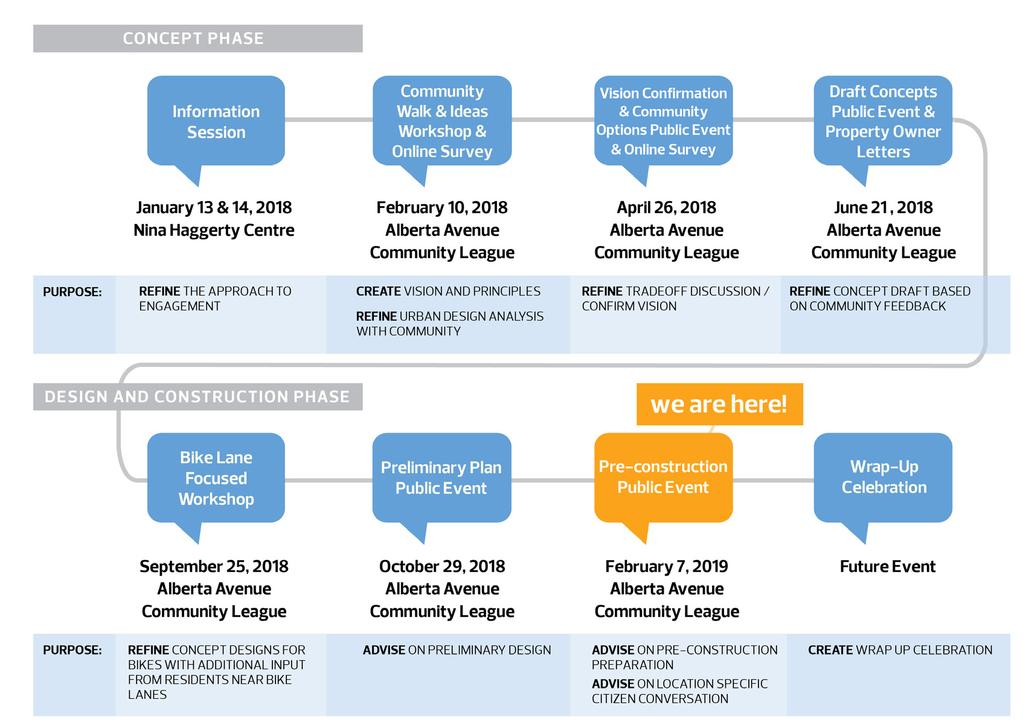
2 EXECUTIVE SUMMARY Starting in 2019, Alberta Avenue will see the replacement and enhancement of its aging collector and local roadway surfaces, street lights, and sidewalks as part of the City of Edmonton s Neighbourhood Renewal program for mature neighbourhoods. Building Great Neighbourhoods has been exploring the enhancement of these and other City owned areas within the community, including green spaces and parks. Building Great Neighbourhoods looks for opportunities to make desired upgrades and improvements in coordination with the Neighbourhood Renewal program. To develop a better understanding of what these enhancements might look like and how they could improve the way people work, live and play in the community we wanted to engage with residents. Engagement began with the Concept phase in January In this phase, the project team developed a vision statement, core values, urban design themes, and focus areas (draft concepts), as well as an Urban Design Analysis. The Urban Design Analysis provided the exploration and foundation of the draft concepts. For more information on the Concept phase, please refer to the project history available online at: edmonton.ca/buildingalbertaavenue The following report tells the story of the public engagement that occurred in the latter portion of the Concept phase and during the preliminary design phase. The first public engagement event in this phase presented refined concept designs for the bike routes to adjacent property owners and asked them to share feedback on the refined bike infrastructure. The next event presented the preliminary designs to the community at large and asked them to provide feedback on the designs to further refine them. Information was also shared on the decorative street light and sidewalk reconstruction local improvement process, construction staging, and next steps. Through the analysis of the feedback gathered at these events, as well as other factors such as City policies and programs, technical requirements, and available funding, the preliminary designs have been finalized and are being presented to the public at the Pre-Construction Event in February The Pre-Construction Event will share the final designs for the neighbourhood, information about what to expect during the planned four-year construction, and additional information on the local improvement process. At the event, residents will be invited to share feedback on construction to help address potential issues that may arise. The event will also provide an opportunity for residents to learn about and participate in the sidewalk local improvement decision.

3 KEY TAKEAWAYS At the preliminary design event, residents had the opportunity to see how the designs had evolved since the Concept phase, and how their input was incorporated into the designs and neighbourhood plan. Generally speaking, residents were supportive of the plan for renewal, and excited about the improvements to pedestrian safety, connectivity, and parks and open spaces that were included in the designs. Several of the key themes within the feedback aligned with the overarching vision and core values, including support for traffic calming measures to help improve safety for people who walk and bike, boulevards with street trees along 115 Avenue to beautify this corridor, and benches and upgraded sidewalk connections at various locations to make the neighbourhood more walkable and inclusive. Other areas of consideration included maintaining community safety in new parks and open spaces, bike infrastructure, parking and traffic calming elements, and the existing playground at St. Faith Park. For more information about the feedback on the preliminary designs, please refer to page 5.


4 Core Values Having viable options to walk, bike, and use 1 Walking and barrier-free accessibility. 2 transit. Gatherings and festivals including Deep Freeze 3 and Kaleido. Vision Statement: Neighbourhood renewal in Alberta Avenue will build a safe and accessible community for all ages, abilities and incomes. We welcome everyone and will make it easy for people to walk and bike, get to places in the neighbourhood, and gather to visit and play. Being part of an inclusive and diverse Celebrating the unique community identity 4 community 5 and mix of cultural heritage. Encouraging positive opportunities and 7 Making the most of parks and green spaces. 8 community-building. Keeping with the unique character of heritage 6 homes and mature trees. Visiting amenities, shops, cafes and 9 restaurants. Limiting harmful impacts from crime and 10 improving safety at all times of day. Preserving and enhancing the natural 11 environment.
5 1.0 BACKGROUND AND ENGAGEMENT OBJECTIVES DECISION-MAKING PROCESS PUBLIC ENGAGEMENT APPROACH YOUR FEEDBACK DECORATIVE STREET LIGHT LOCAL IMPROVEMENT NEXT STEPS 20
 and the Preliminary Design Event (October 2018).")
6 1.0 BACKGROUND AND ENGAGEMENT OBJECTIVES The Alberta Avenue project team began public engagement with the community in January This report includes a summary of the engagement findings from the Bike Lane Workshop (September 2018) and the Preliminary Design Event (October 2018). Public engagement in February 2019 at the Pre-Construction Event is at the ADVISE level and invites the public to share their feedback on possible construction issues and strategies for mitigation. The public also has the opportunity to DECIDE to petition to opt out of the sidewalk local improvement. PUBLIC INPUT 2.0 DECISION-MAKING PROCESS It is important to note that while public engagement is a critical aspect in the decision-making process for neighbourhood renewal, there are several contributing factors that will ultimately determine the final plans, including City policies and programs, technical requirements, and available funding. CITY POLICIES & PROGRAMS FINAL DESIGNS TECHNICAL REQUIREMENTS 1

7 3.0 PUBLIC ENGAGEMENT APPROACH It was important that our approach to engagement considered a broad range of activities to provide residents with different opportunities to share feedback. To achieve this, we held multiple public events throughout the community and provided online opportunities with surveys. Many of the public events were informal in nature and allowed participants to stop in at a time that was convenient for them to learn more about the project and share input on the plans for neighbourhood renewal. Through these activities, residents were able to share their perspective and feedback at various levels of the public engagement spectrum (see below and page 3). Residents were also able to come back to see how their feedback from past events was used as the designs progressed. This approach to engagement fostered a continuous line of communication between the City and community, promoting a transparent and inclusive process. City of Edmonton s Public Engagement Spectrum 2
8 3


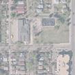
9 The images above are from the Preliminary Design Event on October 29,
10 4.0 YOUR FEEDBACK This section includes a summary of the feedback from the Bike Lane Workshop and Preliminary Design Event. The feedback received has been considered, together with technical considerations, City policies and programs, and available funding to develop the final designs for renewal. 1 BIKE LANE FOCUSED WORKSHOP September 25, 2018 The Bike Lane Focused Workshop provided the opportunity to share the refined bike route design plans with residents that live adjacent to the proposed routes and to gather feedback to determine if any additional revisions were required. Overall, the event provided clarity around the designs for adjacent property owners. Many of the property owners were pleased to see that in most cases, the designs had evolved from the Draft Concept Event (June 2018) to retain the majority of the existing parking, as there was still concern over loss of parking. The bike route design plans were presented at the Preliminary Design Event. What we heard through public feedback on the designs has been consolidated for both events in the following pages. 2 PRELIMINARY DESIGN EVENT October 29, 2018 This event provided the opportunity to share the preliminary design with the public and to gather feedback to consider final changes on the detailed plans where possible. The preliminary design shared at the event are shown on the following pages. These designs were developed based on public feedback received since January 2018, and also considered City policies and programs, technical requirements and available funding. For more information on the project history, please visit: edmonton.ca/buildingalbertaavenue. Residents comments about the neighbourhood renewal plans were generally positive. The following pages include a summary of what we heard in regards to each of the preliminary designs. Engagement Technique : To determine if revisions were required, participants were asked to use sticky notes to provide comments on the designs. At the Preliminary Design Event, participants also learned about the local improvement process, and had the opportunity to fill out and submit a decorative street light Expression of Interest form. 5
")


11 Commercial Area Improvements (121 Avenue and 90 Street) Please refer to styles below for all of the following preliminary designs which include number symbols. What We Heard We heard that residents: Like the new plaza and the sidewalk on the east side of the street Are concerned with parking and the lack of lighting Like the idea of Contemporary (Dark) benches with divider armrests Like the idea of the Mixed paving stone style What We Considered Existing roadway (where plaza is being proposed) would be removed Completing the sidewalk connection on the west side of Delton School Enhancing the sense of place of the area to align with the Urban Design Analysis and core values Two options were shown in June, the preliminary plan was the preferred option based on public feedback What We Decided (Refined Design is being shared at the Feburary 2019 event) Angle parking will be added in front of the commercial units to limit impacts to parking Landscaping, waste receptacles, and pedestrian-level street lighting will be included to enhance the space Custom sized benches with an armrest, and dark grey/brown concrete with a pattern based on the style preferences shared by residents 6
 benches with divider armrests Are concerned with safety and maintenance of the enhanced green space Are interested in shrubs and flower beds being included in the design What We")
12 New Pocket Park (120 Avenue and 92 Street) 7 What We Heard We heard that residents: Like the addition of green space and trees, as well as the improvements to road safety Like the idea of Contemporary (Dark) benches with divider armrests Are concerned with safety and maintenance of the enhanced green space Are interested in shrubs and flower beds being included in the design What We Considered Removal of on-street parking along existing diagonal portion of 120 Avenue Landscaping design standards Configuration of landscape features to promote socializing in the community Working around existing underground and above ground utilities What We Decided (Refined Design is being shared at the Feburary 2019 event) A new park space with pedestrian-friendly amenities such as benches with armrest dividers and new sidewalks Low level shrubs will be planted to enhance the space and maintain sight lines Existing spruce tree to be removed/ relocated and other existing trees will remain A checker board pattern will be added near the new benches in the park space to be used as a game board for children and community members

13 112 Avenue Pocket Park (Between 91 Street and 92 Street) What We Heard We heard that residents: Would like to see more landscaping, lighting and benches within the proposed design Are concerned with safety and the removal of parking Believe that changes to the space may help to liven up the space What We Considered Removal of the on-street turnaround spot Potential access closure at the Northeast property to be confirmed Working around existing trees Relocation of the chain link fence on the south side of the road What We Decided (Refined Design is being shared at the Feburary 2019 event) Existing trees will remain and the green space will be expanded with new trees, shrubs, and a bench to enhance the space for community members to gather and visit Some of the shrubs will include edible Saskatoon Berry and Cherry to help make the most of the green space A new sidewalk will be added on the south side to improve connectivity in this area 8

14 95A Street Sidewalk Connection (to Norwood Centre) What We Heard We heard that residents: Believe that the proposed changes will help with pedestrian accessibility Believe that all other access points around the park should be improved to include curb cuts and step free access Like and dislike the idea of removing the existing turnaround spot What We Considered Necessity to remove planter and existing turnaround spot to improve the sidewalk alignment Walking and barrier-free accessibility What We Decided (Refined Design is being shared at the Feburary 2019 event) A new sidewalk will be added to create an improved connection to the park and the Norwood Child and Family Resource Centre 9

15 St. Faith Park What We Heard We heard that residents: Are concerned with the playground not being upgraded as residents have issues with safety Like the idea of upgrading the playground surface so that it is no longer sand or removing the playground entirely Are concerned that the off-leash dog park may be too small and that it may create noise and waste in the surrounding community Believe that limited hours for the dog park may be a good idea Like the idea of Contemporary (Dark) benches with divider armrests Like the idea of the Mixed paving stone style What We Considered Working around existing trees Reducing dog and pedestrian conflicts Fencing in the dog park due to proximity to the playground What We Decided (Refined Design is being shared at the Feburary 2019 event) A multi-purpose plaza space with hard surfacing in a dark grey concrete colour with a pattern. The plaza space could be used for events and festivals in the area and encourage positive opportunities for community building Fenced off-leash dog park with amenities, such as a bag dispenser, waste receptacles, new landscaping, and pedestrian level lighting. Shrubs will be added at the east end of the dog park to provide some privacy from the plaza space. The east-west sidewalk through the space will be removed to reduce conflicts with dogs and pedestrians and to maximize the space for the dog park Benches added in this space will be black with divider armrests based on the style preference shared by residents 10

 A redesigned streetscape which includes a grassy boulevard and small street trees/shrubs to create a more pedestrian friendly street Narrowing the roadway and")
16 115 Avenue Corridor Improvements Existing Proposed What We Heard We heard that residents: Like that the improvements make the street more pedestrian friendly, especially through the addition of trees Are concerned with narrowing the streets and how this will impact traffic/parking What We Considered Complete Streets Design Standards and minimum requirements for sidewalks, vehicle and parking lane widths 115 Avenue is designated as a collector road with a bus route, and therefore through access needs to be maintained Underground and above ground utilities What We Decided (Refined Design is being shared at the Feburary 2019 event) A redesigned streetscape which includes a grassy boulevard and small street trees/shrubs to create a more pedestrian friendly street Narrowing the roadway and adding curb extensions to reduce speeding/ shortcutting identified by residents throughout the public engagement process. These enhancements will also reduce the distance for pedestrians to cross the street 11

17 97 Street Service Road Existing Proposed What We Heard We heard that residents: Are concerned that the street may be too narrow and believe that the wide parking lane should be maintained Believe that parking should be removed as it is difficult to see cars when turning onto 97 Street Would be interested in speed bumps to slow traffic down What We Considered Maintaining existing two-way traffic Complete Streets Design Standards Working around existing underground and above ground utilities What We Decided (Refined Design is being shared at the Feburary 2019 event) Narrow the existing roadway to meet current City standards which will help reduce speeding identified by residents Widen the boulevard and sidewalk to improve the area for people who walk 12
18 119 Avenue Bike Route (Between 89 and 97 Street) 119 Avenue - West of 93 Street Existing Proposed 119 Avenue - East of 93 Street Existing Proposed 13
19 Through Alberta Avenue Park What We Heard We heard that residents: Like the proposed protected bike lane and believe that it will encourage more people to bike Are concerned about having less street parking, while others believe that there is no need for parking on 119 Avenue Believe that the raised median may cause access issues Believe that there should be consideration for a shared-use path instead of a protected bike lane What We Considered This route is close to commercial/retail destinations along 118 Avenue Opportunity to connect to the Capital Line LRT shared-use path with connection through Eastwood (renewal planned for 2020) Complete Streets Design Standards and working around mature trees Re-configuring the existing medians along 119 Avenue What We Decided (Refined Design is being shared at the Feburary 2019 event) Protected bike lanes with a shared-use path connection through Alberta Avenue Park Reduced road widths and one-way operation between 93 and 97 Street to help address speeding and shortcutting concerns that were shared at past public engagement events Access to existing alleys and driveways will be maintained Loss of on-street parking from 91 to 93 Street and 89 to 90 Street (half of the block) on the south side Removal/relocation of trees at 92 Street/ 119 Avenue Southeast corner and in Alberta Avenue Park. As per the City Tree Policy, any trees to be removed will be assessed and their value will be reinvested into the neighbourhood 14


 One-way road for northbound traffic, shared with northbound travelling")
20 92 Street Bike Route (Between 111 and 119 Avenue) Existing Proposed What We Heard We heard that residents: Like that street parking was maintained on one side, and idea of a one-way road Like and dislike the proposed painted bike infrastructure, with some preferring a protected bike lane with planters, concrete medians, or flexi-posts Believe that snow removal/signs are needed to prevent street parking in the bike lanes Believe that southbound one-way may be better for this particular street What We Considered 92 Street is an existing north-south bike route that is partially comprised of a shared roadway Connection to the Capital Line LRT shared-use path Working around existing mature trees and minimizing impacts to parking Complete Streets Design Standards Identified as a key pedestrian corridor in the Urban Design Analysis, therefore reviewed for construction of 1.8m wide sidewalks to align with Complete Streets What We Decided (Refined Design is being shared at the Feburary 2019 event) One-way road for northbound traffic, shared with northbound travelling bikes One-way southbound bike lane separated by painted buffer on the west side and designated no parking Parking lane on the east side Two-way traffic maintained between the alley access north and south of 118 Avenue to serve the businesses and their associated parking Raised crosswalks and curb extensions at key locations to help slow traffic and improve pedestrian visibility Signal and other upgrades at 111 Avenue and 118 Avenue are under review Wider sidewalks (1.8m) will be constructed along the east and west side of 92 Street 15

 One-way road for southbound traffic, shared with")


21 96 Street Bike Route (Between 111 and 119 Avenue) Existing Proposed What We Heard We heard that residents: Like that street parking was maintained on one side of the road and the idea of a one-way road Like that the proposed concept preserves the boulevard trees and that all road users are represented Believe that changes may not be necessary as there is not much vehicle and bike traffic along 96 Street currently Are concerned that the product to melt the snow in the bike lanes may damage the trees Are concerned that there is not enough existing street parking along 96 Street, especially with the church on Sundays What We Considered What We Decided (Refined Design is being shared at the Feburary 2019 event) One-way road for southbound traffic, shared with southbound travelling bikes One-way northbound bike lane separated by painted buffer on the east side and designated no parking Parking lane on the west side will be retained Two-way traffic maintained where the road widens north and south of 118 Avenue to serve the businesses and their associated parking Signal and other upgrades at 111 Avenue and 118 Avenue are under review Raised crosswalks and curb extensions at key locations to help slow traffic and improve pedestrian visibility 96 Street becomes part of the Downtown Bike Network providing connections through the Quarters and west into Downtown Working around existing mature trees and minimizing impacts to parking Complete Streets Design Standards Improving the area for people who walk and bike Current Snow and Ice Policy 16


 One-way road for westbound traffic, shared with westbound travelling bikes One-way eastbound bike lane separated by painted buffer, located on the")
22 114 Avenue Bike Route (Between 89 and 97 Street) Existing Proposed 17 What We Heard What We Considered We heard that residents: Connection to the broader bike Like that street parking was maintained on one network into Spruce Avenue and to side of the road and the idea of a one-way road the 106 Street shared-use path which Believe that the design will improve the is expected to provide connection into connection to Spruce Avenue infrastructure Blatchford and NAIT Are concerned that there may not be enough Working around existing mature trees bike traffic to need bike lanes and minimizing impacts to parking Are concerned that a one-way road might divert traffic to other roads making them busier Complete Streets Design Standards Are concerned that having to park further Improving the area for people who walk away from home may cause safety issues, and and bike that bike lanes may reduce property value Upgrades to existing street lighting What We Decided (Refined Design is being shared at the Feburary 2019 event) One-way road for westbound traffic, shared with westbound travelling bikes One-way eastbound bike lane separated by painted buffer, located on the south side of 114 Avenue Existing on-street parking on the north side of the avenue will be retained New angle parking on the north side between 94 Street and the alley west of 95 Street (roadway widens in these areas) Signal and other upgrades for improved connectivity for people who walk and bike to cross the arterial roads at 95 Street and 97 Street are under review


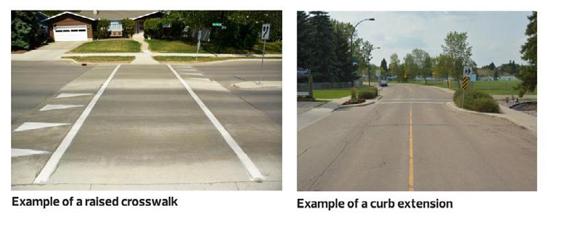
23 Preliminary Traffic Calming Plan What We Heard We heard that residents: Like the addition of curb extensions and raised crosswalks to reduce speeding throughout the neighbourhood Are concerned with the raised crosswalks not being properly scraped in the winter Believe additional traffic calming measures are needed at 111 Avenue and 92 Street, 113 Avenue and 91 Street, along 95 Street, and 115 Avenue What We Considered Accommodating emergency services Designing curb extensions to minimize impacts to parking Accommodating proper drainage Compatibility with bike facilities Addressing driver behaviours on resident s roadways of concern What We Decided (Refined Design is being shared at the Feburary 2019 event) Curb extensions and raised crosswalks added at key locations to work as a system, based on community feedback that these were the preferred traffic calming measures Curb extension added at 91 Street and 113 Avenue based on feedback to discourage speeding on 91 Street and shorten the crossing distance for pedestrians Curb extension removed on east side of 117 Avenue and 95A Street. Speeding will still be discouraged with the curb extension remaining on the west side and impacts to parking will be reduced Raised crosswalk removed at 94 Street and 121 Avenue due to lack of existing drainage infrastructure to tie into 18

 notices to registered property owners with the proposed decorative street light design (heritage, fluted, dark green) and cost estimate in September 2018.")
24 5.0 DECORATIVE STREET LIGHT LOCAL IMPROVEMENT The Neighbourhood Renewal Program covers the full cost to replace all street lights with standard galvanized poles, LED lights, and street address blades. The community may bring forth a submission to upgrade to decorative street lights through a cost-sharing opportunity with the City. A submission was received in Summer 2018 which included the following: Decorative Arm: Heritage Pole Style: Fluted Pole Colour: Dark Green Expression of Interest Upon reviewing the submission, the City sent Expression of Interest (EOI) notices to registered property owners with the proposed decorative street light design (heritage, fluted, dark green) and cost estimate in September To proceed, the City required 50% + 1 support from property owners and a minimum of 507 submissions for Alberta Avenue by November 20, The City did not receive the minimum requirement of 507 submissions, and therefore the Expression of Interest for decorative street lights did not proceed. Upgrades to the existing street light system will still be made and will include: New 24 foot galvanized poles New underground wiring New foundation Energy efficient LED lights In neighbourhoods with mature trees, the height of the poles is lowered by 4 feet to reduce obstruction from the tree canopy, allowing better road and sidewalk lighting. 19

25 6.0 NEXT STEPS The Pre-Construction Event is being held in February The final neighbourhood designs were developed based on the feedback received throughout the public engagement process from January to October 2018, and also considered City policies and programs, technical considerations, and available funding. Construction is expected to begin in Spring The project team will continue to share construction information with residents as it progresses. For additional information please visit the project website: edmonton.ca/buildingalbertaavenue Or contact: Donny Fung, Delivery Project Manager 20
26 edmonton.ca/buildingalbertaavenue
FOCUS AREA 1 - Alberta Avenue Pocket Park 3 (121 Ave and 92 St)
") FOCUS AREA 1 - Alberta Avenue Pocket Park 3 (121 Ave and 92 St) New benches Plant evergreen trees Widen existing sidewalk from 1.5m to 1.8m Marked crosswalk 1.8m wide sidewalk Add pedestrian oriented lights
FOCUS AREA 1 - Alberta Avenue Pocket Park 3 (121 Ave and 92 St) New benches Plant evergreen trees Widen existing sidewalk from 1.5m to 1.8m Marked crosswalk 1.8m wide sidewalk Add pedestrian oriented lights
Tonight is for you. Learn everything you can. Share all your ideas.
 Strathcona Neighbourhood Renewal Draft Concept Design Tonight is for you. Learn everything you can. Share all your ideas. What is Neighbourhood Renewal? Creating a design with you for your neighbourhood.
122 Avenue: 107 Street to Fort Road
 : 107 Street to Fort Road November 24, 2015 4:30 8:00 p.m. Meeting Purpose Summarize project work completed to date Share results of public input from Phase 1 Share the draft concept plan and proposed
CLOSED. Highlights of the Final Concept Design:
 The final Concept Design is the result of many months of listening, learning, creating, balancing, and understanding different needs and viewpoints, as well as incorporating technical requirements and
CLOSED. The draft concept design has been broken down into 5 categories for the purpose of this survey:
 Old Strathcona s neighbourhood renewal process is now at the draft concept design phase. Over the last several months, the city has been gathering local knowledge and resident input that has been used
WELCOME. Purpose of the Open House. Update you on the project. Present a draft recommended plan. Receive your input
 WELCOME Purpose of the Open House The Town of Smiths Falls has initiated the Beckwith Street Redevelopment Plan that includes the preparation of a streetscape functional design for the renewal of Beckwith
Saskatchewan Drive Roadway Rehabilitation and Shared-Use Path Widening
 Saskatchewan Drive Roadway Rehabilitation and Shared-Use Path Widening We are here today to present the draft plan for the Saskatchewan Drive Roadway Rehabilitation and Shared-Use Path Widening project
STONY PLAIN ROAD STREETSCAPE
 Jasper Place Revitalization Strategy: Vision The people involved in the Jasper Place Revitalization Strategy envision: Goal 1: Feeling safe in our community Create a community where feeling safe is common--where
2014/2015 BIKE ROUTE PLAN 83 AVENUE PROTECTED BIKE LANE
 About the Project The City of Edmonton is planning a major bike route on the southside of Edmonton. The Strathcona Bike Route will connect the communities of Strathcona, Garneau and the University area,
2014/2015 BIKE ROUTE PLAN 83 AVENUE PROTECTED BIKE LANE
 About the Project 2014/2015 BIKE ROUTE PLAN The City of Edmonton is planning a major bike route on the south side of Edmonton. This bike route is one part of a plan to provide citizens with transportation
Complete Streets. Designing Streets for Everyone. Sarnia
 Complete Streets Designing Streets for Everyone Sarnia Complete Streets ~ Sarnia ~ 2018 Introduction Our City is made up of a network of streets that we use to go for a walk, cycle to work, drive to the
A CHANGING CITY. of Edmonton, it is essential that it reflects the long-term vision of the City.
 A CHANGING CITY By the year 2040, Edmonton will be home to more than 1 million people. To accommodate growth and support a healthy and compact city, we need a new approach to development/redevelopment
Building Great Neighbourhoods BELLEVUE AND VIRGINIA PARK
 Building Great Neighbourhoods BELLEVUE AND VIRGINIA PARK This is Meeting 2 Unfortunately, some residents in Bellevue and Virginia Park received the wrong information for this public open house (Meeting
Terwillegar Drive Expressway Draft Concept Plan
 Terwillegar Drive Expressway Draft Concept Plan Anthony Henday Drive to Whitemud Drive November 28 5:00-8:00 p.m. December 1 10:00 a.m. - 3:00 p.m. Let s Talk Today you can: Learn about the new direction
complete streets design and construction standards public primer City of Edmonton
 complete streets design and construction standards public primer City of Edmonton introduction Complete Streets are streets for everyone: people who walk, wheel, bike, take transit, or drive. They are
Vision: Traditional hamlet with an attractive business/pedestrian friendly main street connected to adjacent walkable neighborhoods
 N D. Focus Area II Vision: Traditional hamlet with an attractive business/pedestrian friendly main street connected to adjacent walkable neighborhoods Transit Road Focus Area II is located in the Hamlet
Building Great Neighbourhoods LANSDOWNE
 Building Great Neighbourhoods LANSDOWNE We are here today to Explain how the City is investing in improving your neighbourhood and how your neighbourhood will be improved to meet current City standards.
MARTIN LUTHER KING JR. WAY
 OCTOBER 2011 40 Vision and Goals The Martin Luther King, Jr. Way Illustrative Master Plan that follows has been developed through a process of community involvement. It expresses a long term vision for
Executive Summary Route 30 Corridor Master Plan
 Route Corridor Master Plan Project Overview The Route Corridor Master Plan is a coordinated multimodal transportation and land use plan for the entire stretch of Route through East Whiteland Township,
Road Alterations - Wellington Street East, Church Street, and Front Street Intersection
 REPORT FOR ACTION Road Alterations - Wellington Street, Church Street, and Front Street Intersection Date: November 1, 2016 To: Toronto and York Community Council From: Director, Public Realm Section,
Major Bike Routes 102 Avenue Workshop April 21, 2015
 Major Bike Routes 102 Avenue Workshop April 21, 2015 Our Purpose Today Provide context on how Major Bike Routes fit into Edmonton s future Share information on what we heard in our last phase, and how
THE ALAMEDA CONCEPT DESIGN COMMUNITY MEETING 3. A Plan for The Beautiful Way JANUARY 28, 2010
 CONCEPT DESIGN COMMUNITY MEETING 3 JANUARY 28, 2010 AGENDA INTRODUCTION COMMUNITY INPUT ROADWAY STUDIES STREETSCAPE DESIGN STATIONS DISCUSSION SUMMARY AND DISCUSSION NEXT STEPS CLOSE INTRODUCTION SCHEDULE
Community Meeting February 27, 2007 Dorchester Avenue Transportation & Streetscape Improvements Action Plan February 27, 2007
 Community Meeting Tonight s Agenda 6:00 Introductions South Boston/Dot Ave Improvement Study Background 6:15 Consultant Introductions Review of Scope and Schedule Review of Proposed Corridor Wide Guidelines
STEERING COMMITTEE MEETING June 17, Streetscape Overview Burlington Comprehensive Master Plan
 STEERING COMMITTEE MEETING June 17, 2015 Streetscape Overview Burlington Comprehensive Master Plan 1 Introduction Slide This slide show was presented to the Burlington Steering Committee on June 17, 2015
162 RESIDENTS ATTENDED 2 DAYS OF WORKSHOPS 15 TABLE DISCUSSIONS WHAT WE HEARD. Oakridge Municipal Town Centre Workshops PLANNING PROGRAM
 OAKRIDGE MTC WORKSHOP 2017 CAMBIE CORRIDOR Phase 3 STEP 3: 3: October June 2017 CAMBIE CORRIDOR PLANNING PROGRAM 2 DAYS OF WORKSHOPS 15 TABLE DISCUSSIONS 162 RESIDENTS ATTENDED WHAT WE HEARD Oakridge Municipal
Building Great Neighbourhoods BONNIE DOON
 Building Great Neighbourhoods BONNIE DOON We Are Here Today To Explain the Neighbourhood Renewal Process Show you the Westwood Preliminary Design Ask for local knowledge Highlight the Local Improvement
Welcome. If you have any questions or comments on the project, please contact:
 Welcome This drop-in public open house is intended to provide information about the Bay Street bike lanes project. This project proposes a dedicated cycling facility along Bay Street between Aberdeen Avenue
Why invest in the 1 Street S.W. Corridor?
 Why invest in the 1 Street S.W. Corridor? This project is an investment in the Beltline Community and Calgary s economy. It is anticipated that The City s investment along this corridor will help with
TRANSPORTATION COMMISSION Agenda Staff Report
 TRANSPORTATION COMMISSION Agenda Staff Report Agenda Item No. 5.a DATE: JULY 31, 2014 TO: FROM: SUBJECT: TRANSPORTATION COMMISSION COMMUNITY DEVELOPMENT DEPARTMENT - PLANNING DRAFT OLYMPIC CORRIDOR PREFERRED
WELCOME Public Information Centre
 WELCOME Public Information Centre Fernforest Drive Brampton Soccer Centre Community Room #2 Tuesday January 19, 2016 6:30 p.m.to 9:00 p.m. Please sign in Neighbourhood Traffic Calming Guide Background
CONNECTIVITY PLAN. Adopted December 5, 2017 City of Virginia Beach
 CONNECTIVITY PLAN Adopted December 5, 2017 City of Virginia Beach CONTENTS 1.0 Background & Purpose... 2 2.0 Existing Inventory & Analysis... 3 ViBe District Existing Walking Conditions... 4 3.0 ViBe District
Memo. Ocean Avenue Corridor Design Project Public Workshop #2 Summary
 Ocean Avenue Corridor Design Project Public Workshop #2 Summary The second public workshop for the Ocean Avenue Corridor Design Project was held on Wednesday, May 14, 2014 from, 6 to 8 pm at Lick Wilmerding
83 AVENUE PRE-CONSTRUCTION MEETING
 83 AVENUE PRE-CONSTRUCTION MEETING April 6, 2017 5-8PM Please visit displays for project information Talk to staff, ask questions, visit website at: www.edmonton.ca/bike83avenue Pre-Construction Meeting
EXECUTIVE SUMMARY. Vision
 Vision Walking and bicycling in Salt Lake City will be safe, convenient, comfortable, and viable transportation options that connect people to places, foster recreational and economic development opportunities,
Public Information Centre
 WELCOME Public Information Centre Father Tobin Road Lougheed Middle School - Library Wednesday November 7, 2012 7:00 p.m.to 9:00 p.m. Please sign in Neighbourhood Traffic Calming Guide Background The City
Ann Arbor Downtown Street Plan
 1 Ann Arbor Downtown Street Plan Public Workshop #1 We know that. 2 Public right-of-way (streets, sidewalks, and alleys) make up 30% of the total District area of downtown. Streets need to provide mobility
Building Great Neighbourhoods QUEEN ALEXANDRA
 Building Great Neighbourhoods QUEEN ALEXANDRA We are here today to Explain how the City is investing in improving your neighbourhood and how your neighbourhood will be improved to meet current City standards.
Report. Typical Sections. City of Middleton, WI
 Report Typical Sections City of Middleton, WI December 2006 Report for City of Middleton, Wisconsin Typical Sections repared by: Traffic Associates LLC and STRAND ASSOCIATES, INC. 910 West Wingra Drive
Henderson Ave. Complete Streets Project
 Henderson Ave. Complete Streets Project Meeting Purpose To finalize conceptual components of project prior to proceeding with preliminary engineering www.dallascompletestreets.wordpress.com MeetingAgenda
Chapter 3: Multi-Modal Circulation and Streetscapes
 CHAPTER 3: MULTI-MODAL CIRCULATION AND STREETSCAPES Chapter 3: Multi-Modal Circulation and Streetscapes Overview Streetscape improvements have already been completed for Depot Street between Main Avenue
Building Great Neighbourhoods STRATHEARN
 Building Great Neighbourhoods STRATHEARN Public Involvement Community League Meeting #1: October 5, 2015 Public Meeting #2: March 15, 2016 Public Meeting #3: January 17, 2017 Building Great Neighbourhoods
Feasibility Study. Expo-Downtown Bicycle Connector
 Feasibility Study Expo-Downtown Bicycle Connector May 2017 Table of Contents Introduction... 2 Project Goals... 2 Study Scope... 2 Community Engagement... 3 Project Description... 6 Considerations... 6
UPTOWN REGIONAL BIKE CORRIDORS PROJECT SAN DIEGO ASSOCIATION OF GOVERNMENTS
 UPTOWN REGIONAL BIKE CORRIDORS PROJECT SAN DIEGO ASSOCIATION OF GOVERNMENTS SUMMARY REPORT: COMMUNITY UPDATE MEETING February 6, 2014 6 8:30 p.m. Roosevelt Middle School Library 3366 Park Blvd, San Diego
Ocean Park Boulevard Green Street Project Community Workshop
 Ocean Park Boulevard Green Street Project Community Workshop 2.2.10 Project Objectives Community Priority: reclaim OPB for public open space. Build upon LUCE principles; neighborhood enhancement, connectivity,
Governance and Priorities Committee Report For the July 2, 2015 Meeting
 CITY OF VICTORIA For the July 2, 2015 Meeting To: Governance and Priorities Committee Date: From: Subject: Brad Dellebuur, A/Assistant Director, Transportation and Parking Services Executive Summary The
In station areas, new pedestrian links can increase network connectivity and provide direct access to stations.
 The Last Mile Planning for Pedestrians Planning around stations will put pedestrians first. Making walking to stations safe and easy is important; walking will be a part of every rapid transit Accessible
TRAFFIC CALMING GUIDE FOR TORONTO CITY OF TORONTO TRANSPORTATION SERVICES DIVISION
 TRAFFIC CALMING GUIDE FOR TORONTO CITY OF TORONTO TRANSPORTATION SERVICES DIVISION CITY OF TORONTO TRANSPORTATION SERVICES DIVISION 2016 TRAFFIC CALMING GUIDE FOR TORONTO TABLE OF CONTENTS Introduction
Draft North Industrial Area-Wide Traffic Plan
 Summary of North Industrial and Hudson Bay Industrial Recommended Improvements Table 1. Summary of s Item Location 1 2 3 4 5 6 7 8 9 10 11 12 Millar Ave north of 51st St Super 8 Motel back lane 400 Block
TRANSPORTATION NEEDS ASSESSMENT
 TRANSPORTATION NEEDS ASSESSMENT A travel demand analysis was carried out to determine the operational issues and the potential benefit that adding traffic capacity would have on the road network. All the
FOLSOM-HOWARD STREETSCAPE OVERVIEW
 FOLSOM-HOWARD STREETSCAPE OVERVIEW SoMa residents should have the same kinds of amenities that other neighborhoods have. The Folsom- Howard Streetscape Project will make SoMa more livable by making it
Omaha s Complete Streets Policy
 Omaha s Complete Streets Policy (Adopted August 2015) VISION To create great places and enhance our quality of life, the City of Omaha will provide safe, accessible streets for all users. Complete Streets
Duwamish Way-finding and CTR Report
 V. North Tukwila When the North Tukwila Manufacturing and Industrial Center was designated in 1992 as part of the region s land use and transportation plan, the plan called for the area to set a light-rail
Streetscape: Core Shopping District
 Streetscape: Core Shopping District DRAFT DRAFT DRAFT May 00 Core Shopping District: Phase Blue Island s Core Shopping District is located along Western Avenue, between Grove and Union Streets. Streetscape
GLEN EIRA CITY COUNCIL. MURRUMBEENA Transforming our neighbourhood together our concepts based on your ideas
 GLEN EIRA CITY COUNCIL MURRUMBEENA Transforming our neighbourhood together our concepts based on your ideas 1 WHAT HAVE WE HEARD? WHAT NOW? Stage one Tell us what you love about your shopping strip November
Ocean Park Boulevard Green Street Project Alternatives & Trade Offs
 Planning Commission March 4, 2009 Ocean Park Boulevard Green Street Project Alternatives & Trade Offs Purpose of Tonight s Meeting Review concept plans and options Provide input on alternatives and trade-offs
University of Victoria Campus Cycling Plan Terms of Reference. 1.0 Project Description
 University of Victoria Campus Cycling Plan Terms of Reference 1.0 Project Description The Campus Cycling Plan, a first for the University, will provide a comprehensive and coordinated approach to support
NEWMARKET UPHAM S CORNER
 SOUTH STATION Planning Initiative NEWMARKET UPHAM S CORNER COLUMBIA ROAD (P) FOUR CORNERS/GENEVA Working Advisory Group (WAG) Meeting #5 TALBOT AVENUE MORTON STREET BLUE HILL AVE/CUMMINS HWY (P) RIVER
Lee s Summit Road Improvement Study Public Open House June 7, 2007 Summary of Comment Card Responses
 Lee s Summit Road Improvement Study Public Open House June 7, 2007 Summary of Comment Card Responses Introduction At the Lee s Summit Road Improvement Study Public Open House held Thursday, June 7, 2007
50 Avenue S.W. Corridor Study Glenmore Aquatic Centre Drop-In Event
 Project overview The City of Calgary is conducting a transportation corridor study of 5 Avenue S.W., between Crowchild Trail and 4A Street S.W. In 29, it was reclassified as a Parkway under the Calgary
Fulton Market Streetscape
 Fulton Market Streetscape Ogden Avenue to Halsted Street Public Meeting Recommended Improvements December 10th, 2014 Meeting Purpose and Goals Present Existing Conditions Community Input and Charrette
Polk Streetscape Project
 What is this project? The Polk Streetscape Project is an effort to improve safety for everyone traveling on Polk Street between Union and McAllister streets. Also included in this project are paving, sewer
102 Avenue Corridor Review
 February 26, 2015 102 Avenue Corridor Review Transportation Association of Canada Road Safety Engineering Award Submission for the City of Edmonton Introduction Transportation Association of Canada Road
CRESTON ROAD COMPLETE AND SUSTAINABLE STREETS CORRIDOR PLAN
 CRESTON ROAD COMPLETE AND SUSTAINABLE STREETS CORRIDOR PLAN Preferred Plan Community Presentation September 27, 2017 City of El Paso de Robles in partnership with: Local Government Commission, W-Trans,
Byron Avenue. Public Meeting. Thursday June 16, Traffic Calming Design Sherbourne Road to Island Park Drive
 Byron Avenue Traffic Calming Design Sherbourne Road to Island Park Drive Public Meeting Thursday June 16, 2016 Our Lady of Fatima Parish 153 Woodroffe Avenue 6 9pm 1 Project Summary Area Projects Background
Broad Street Bicycle Boulevard Design Guidelines
 Broad Street Bicycle Boulevard Design Guidelines Building from the strategies introduced in the 2013 Bicycle Transportation Plan and community input received thus far, City Transportation Staff have identified
Montgomery County Life Sciences Center Loop Trail
 Montgomery County Life Sciences Center Loop Trail Advisory Committee Meeting #1 February 10, 2015 Agenda 1. Project Background 2. Existing Conditions Analysis 3. Examples from Elsewhere 4. Discussion Project
CITY OF OTTAWA ROADWAY MODIFICATION APPROVAL UNDER DELEGATED AUTHORITY
 RMA-2015-ATM-038 CITY OF OTTAWA ROADWAY MODIFICATION APPROVAL UNDER DELEGATED AUTHORITY DATE: April 22, 2015 SUBJECT Approval of Roadway Modifications Recommended through an Area Traffic Management Study
Safe Routes to School: Valverde Elementary Walk Audit Report. Image: CPLIVE, SkyscraperPage.com
 Safe Routes to School: Valverde Elementary Walk Audit Report Image: CPLIVE, SkyscraperPage.com April 28, 2016 1 OVERVIEW As part of the 2014/2015 Denver Safe Routes to School (SRTS) Program, WalkDenver
REGIONAL BICYCLE AND PEDESTRIAN DESIGN GUIDELINES
 REGIONAL BICYCLE AND PEDESTRIAN DESIGN GUIDELINES November 16, 2011 Deb Humphreys North Central Texas Council of Governments Bicycle and Pedestrian Advisory Committee Snapshot of the Guide 1. Introduction
Pedestrian Crosswalk Audit
 1200, Scotia Place, Tower 1 10060 Jasper Avenue Edmonton, Alberta T5J 3R8 edmonton.ca/auditor Pedestrian Crosswalk Audit June 19, 2017 The conducted this project in accordance with the International Standards
Southview Blvd & 3 rd Avenue Improvement Project. Public Open House December 4, to 7pm
 Southview Blvd & 3 rd Avenue Improvement Project Public Open House December 4, 2014 5 to 7pm Southview Blvd & 3 rd Avenue Public Information Meeting Agenda Presentation 5:30 to 6:15 pm Purpose of Project
5. RUNNINGWAY GUIDELINES
 5. RUNNINGWAY GUIDELINES These guidelines should be considered collectively when making runningway decisions. A runningway is the linear component of the transit system that forms the right-of-way reserved
Brooklyn Boulevard (County Road 152) Reconstruction Project Phase I. OPEN HOUSE June 20, 2017
 Reconstruction Project Phase I. OPEN HOUSE June 20, 2017") Brooklyn Boulevard (County Road 152) Reconstruction Project Phase I OPEN HOUSE June 20, 2017 Brooklyn Boulevard (County Road 152) Phase I Project Partners Project Lead Other Project Partners include Brooklyn
Brooklyn Boulevard (County Road 152) Reconstruction Project Phase I OPEN HOUSE June 20, 2017 Brooklyn Boulevard (County Road 152) Phase I Project Partners Project Lead Other Project Partners include Brooklyn
Welcome to the Open House
 Leslie Street Between 19 th Avenue and Stouffville Road Addendum to Class Environmental Assessment Study Welcome to the Open House Please sign in at the front desk. March 28, 2017 Richmond Green Sports
Figure 4-10: Pedestrian Improvements Types of Potential Station Area Improvements - Place-Making Improvements
 INCORPORATE FEATURE PAVIN IN CROSSWALK AND INTERSECTION FIELDS Identifies high-priority pedestrian areas and create a station identity through colorful and interesting patterns ADD CURB EXTENSIONS Extending
Community Workshop #1 Summary October 2017
 Community Workshop #1 Summary October 2017 1 Background Pleasure Point has a unique character and strong community identity. In 2008, the community and the County developed the Pleasure Point Community
Station 1: Street & Sidewalk Upgrades
 Station 1: Street & Sidewalk Upgrades Existing no left turn; Potential left turn arrow, see Circulation Study boards for more information Thru-lane guidance Improved lead-in green bike lane 17TH ST CASTRO
Comments The Plan for Port Whitby
 Comments The Plan for Port Whitby April 24th, 2013 Community Meeting #2 Summary Report Prepared by GLPi April 29th, 2013 1 Introduction The purpose of the Port Whitby Secondary Plan Update, Community Improvement
TRANSPORTATION STANDARDS
 INTRODUCTION LOCAL STREETS ON-STREET PARKING SIDEWALKS STREET LIGHTING STREET FURNISHINGS TRAFFIC CALMING STREET TREES MEDIAN PLANTING BOULEVARD LOCATIONS VILLAGE CENTER STREET LOCATIONS RESIDENTIAL STREET
6.4 RECOMMENDED IMPROVEMENTS
 6.4 RECOMMENDED IMPROVEMENTS 6.4.1 Williston Road Recommendations While all alternatives would be an improvement over existing conditions, Alternative 3B is recommended over the others because it provides
5 Circulation & Parking
 5 Circulation & Parking Downtown Parking & Circulation Strategy. Downtown Wayne has a somewhat disconnected system of local public streets to connect downtown with the residential neighborhoods, and primary
PEDESTRIAN ACTION PLAN
 ATTACHMENT 2 CITY OF SANTA MONICA PEDESTRIAN ACTION PLAN CITY OF SANTA MONICA PEDESTRIAN ACTION PLAN This page intentionally left blank EXECUTIVE SUMMARY CHAPTER 1 EXECUTIVE SUMMARY Setting the Stage
Glebe Neighbourhood Cycling Plan
 Glebe Neighbourhood Cycling Plan Summary of Public Comments received after June 5 th Public Information Session Comment STUDY NETWORK CS9, CS8, E, E0 CS4, E CS4 CS8 E Suggestions for alternate cycling
Complete Streets for Niagara A working method to visualize the creation of a complete street June 20th, 2013
 Complete Streets for Niagara A working method to visualize the creation of a complete street June 20th, 2013 C O N T E N T S Introduction and background of the report What is a complete street? What can
Welcome to the Public Meeting. Red Hill Business Park South Transportation Master Plan Addendum. December 4, :00 p.m. to 8:00 p.m.
 Welcome Welcome to the Transportation Master Plan Addendum December 4, 2012 6:00 p.m. to 8:00 p.m. Please sign-in Background PIC#1 Public Information Centre #1 (PIC#1) was held on June 25, 2012. Feedback
Caltrans Sloat Boulevard Pedestrian Safety Project Response to Community Questions, Comments & Concerns
 Caltrans Sloat Boulevard Pedestrian Safety Project Response to Community Questions, Comments & Concerns Revised: May 10, 2016 The California Department of Transportation (Caltrans) is planning various
Downey Road. Transportation Improvement Study
 Downey Road Transportation Improvement Study Workshop 2 Participant Handbook Workshop 1 May 18 and 19, 2016 Workshop 2 June 23 and 28, 2016 Prepared By: City of Guelph Paradigm Transportation Solutions
Transportation Assessment
 Transportation Assessment Midtown Open House February 10, 2018 Overview Midtown in Focus Overview & Purpose of Today Transportation Assessment overview Summary of Transportation work to date Review & Analysis
Cross Street Corridor Non-Motorized Enhancement Project Project Description
 Cross Street Corridor Non-Motorized Enhancement Project Project Description A cooperative study of the Cross Street neighborhood was completed in May 2002 by the City of Ypsilanti, the Depot Town Downtown
City of Davis East Covell Corridor Plan
 Community Open House #2 January 22, 2014 6:00 8:00 p.m. Veterans Memorial Center, Club Room City of Davis Introduction The (ECCP) is a taking a comprehensive look at the existing transportation systems
City of Sammamish. Welcome. Issaquah-Fall City Road Improvements Project Phase I Design: 242nd Avenue SE to Klahanie Drive SE
 Welcome Welcome to the third community meeting for the Issaquah-Fall City Road Improvements Project. AGENDA 6:00 p.m. Welcome and sign-in 6:10 p.m. Presentation 6:50 p.m. Open house Learn about the roadway
Option W: N. Washington Street Project
 Option W: N. Washington Street Project Location: one block of North Washington Street, between West Broad Street and Park Avenue Description: upgrades to existing lighting new brick sidewalk to replace
Ocean Park Boulevard Streetscape Improvement Project Alternatives & Trade Offs
 City Council Study Session January 27, 2009 Ocean Park Boulevard Streetscape Improvement Project Alternatives & Trade Offs Scope of Work Purpose of Tonight s Meeting Review work to date and direct staff
5 CIRCULATION AND STREET DESIGN
 5 CIRCULATION AND STREET DESIGN This chapter describes circulation and streetscape improvements proposed for the Northwest Chico Specific Plan Area. It includes detailed design specifications for existing
Wyldewood Estates. Pre-Application Public Engagement Summary of Issues and Responses
 Wyldewood Estates Pre-Application Public Engagement Summary of Issues and Responses March 2016 Executive Summary Morguard Residential Properties has been thoughtfully planning the redevelopment of Wyldewood
Safe Routes to School: Munroe Elementary Walk Audit Report. Image: Drexel, Barrell & Co.
 Safe Routes to School: Munroe Elementary Walk Audit Report Image: Drexel, Barrell & Co. April 12, 2016 OVERVIEW As part of the 2014/2015 Denver Safe Routes to School (SRTS) Program, WalkDenver coordinated
BETHEL ROAD AND SEDGWICK ROAD CORRIDOR STUDY
 DRAFT PLAN City Council Meeting August 14, 2017 STUDY AREA Sedgwick Corridor State Route 160, principal arterial with Class 3 access management designation, commuter and freight route, connection to SR
Pre-Construction Meeting
 Pre-Construction Meeting Wednesday, March 21 Drop-in from 5 9pm Please visit displays for project information, talk to staff, and ask questions! Edmonton.ca/SouthsideBikeRoutes Objectives & Project Scope
Observations and Ideas: Toomer s Corner Streetscape Improvements
 Observations and Ideas: Toomer s Corner Streetscape Improvements AUBURN DOWNTOWN MASTER PLAN planning downtown s future August 26, 2013 Observations: Vertical Clutter at Corners 6 3 7 5 9 2 8 4 1 Excess
Clarkson Walkability Audit: Results and Recommendations Summary
 Clarkson Walkability Audit: Results and Recommendations Summary The following document was prepared by the Region of Peel and includes a summary of comments made by participants during our breakout discussion