Parking Lot P6C Transportation Impact Assessment
|
|
|
- Bryce Craig
- 5 years ago
- Views:
Transcription
1 Transportation Carleton University Parking Lot P6C Transportation Impact Assessment Prepared by: AECOM Morrison Drive tel Ottawa, ON, Canada K2H 8S fax Project Number: Date: March 2013
2 AECOM Carleton University Parking Lot P6C Transportation Impact Assessment Statement of Qualifications and Limitations The attached Report (the Report ) has been prepared by AECOM Canada Ltd. ( Consultant ) for the benefit of the client ( Client ) in accordance with the agreement between Consultant and Client, including the scope of work detailed therein (the Agreement ). The information, data, recommendations and conclusions contained in the Report (collectively, the Information ): is subject to the scope, schedule, and other constraints and limitations in the Agreement and the qualifications contained in the Report (the Limitations ); represents Consultant s professional judgement in light of the Limitations and industry standards for the preparation of similar reports; may be based on information provided to Consultant which has not been independently verified; has not been updated since the date of issuance of the Report and its accuracy is limited to the time period and circumstances in which it was collected, processed, made or issued; must be read as a whole and sections thereof should not be read out of such context; was prepared for the specific purposes described in the Report and the Agreement; and in the case of subsurface, environmental or geotechnical conditions, may be based on limited testing and on the assumption that such conditions are uniform and not variable either geographically or over time. Consultant shall be entitled to rely upon the accuracy and completeness of information that was provided to it and has no obligation to update such information. Consultant accepts no responsibility for any events or circumstances that may have occurred since the date on which the Report was prepared and, in the case of subsurface, environmental or geotechnical conditions, is not responsible for any variability in such conditions, geographically or over time. Consultant agrees that the Report represents its professional judgement as described above and that the Information has been prepared for the specific purpose and use described in the Report and the Agreement, but Consultant makes no other representations, or any guarantees or warranties whatsoever, whether express or implied, with respect to the Report, the Information or any part thereof. Without in any way limiting the generality of the foregoing, any estimates or opinions regarding probable construction costs or construction schedule provided by Consultant represent Consultant s professional judgement in light of its experience and the knowledge and information available to it at the time of preparation. Since Consultant has no control over market or economic conditions, prices for construction labour, equipment or materials or bidding procedures, Consultant, its directors, officers and employees are not able to, nor do they, make any representations, warranties or guarantees whatsoever, whether express or implied, with respect to such estimates or opinions, or their variance from actual construction costs or schedules, and accept no responsibility for any loss or damage arising therefrom or in any way related thereto. Persons relying on such estimates or opinions do so at their own risk. Except (1) as agreed to in writing by Consultant and Client; (2) as required by-law; or (3) to the extent used by governmental reviewing agencies for the purpose of obtaining permits or approvals, the Report and the Information may be used and relied upon only by Client. Consultant accepts no responsibility, and denies any liability whatsoever, to parties other than Client who may obtain access to the Report or the Information for any injury, loss or damage suffered by such parties arising from their use of, reliance upon, or decisions or actions based on the Report or any of the Information ( improper use of the Report ), except to the extent those parties have obtained the prior written consent of Consultant to use and rely upon the Report and the Information. Any injury, loss or damages arising from improper use of the Report shall be borne by the party making such use. This Statement of Qualifications and Limitations is attached to and forms part of the Report and any use of the Report is subject to the terms hereof. AECOM: AECOM Canada Ltd. All Rights Reserved. DRAFT RPT Traffic Impact Assessment.Doc


3
4 AECOM Carleton University Parking Lot P6C Transportation Impact Assessment Table of Contents Statement of Qualifications and Limitations Distribution List 1. Introduction Overview Previous Studies Study Area Transportation Network Road Network Transit Pedestrian and Bicycle Facilities Existing Conditions Traffic Volumes Traffic Operations Future Conditions Future Projections Traffic Distribution and Assignment Total Traffic Volume Traffic Control and Geometric Requirements Future Traffic Operations Conclusions and Recommendations List of Figures Figure 1. Campus Master Plan Parking Locations (2010)... 2 Figure 2. Existing and Planned Campus Street System... 4 Figure 3. Existing Transit Service... 5 Figure 4. Campus Map... 6 Figure Traffic Volumes... 8 Figure 6. Traffic Volumes 2013 post construction Figure 7. Traffic Volumes in List of Tables Table 1. City of Ottawa - Level of Service... 3 Table 2. Carleton Trip Generation... 7 Table 3. Existing 2013 Baseline Traffic Operations... 9 Table Buildout Traffic Operations Table Traffic Operations Appendices Appendix A. Appendix B. Traffic Counts/Traffic signal timing supplied by City of Ottawa Synchro Simulation results page DRAFT RPT Traffic Impact Assessment.Doc
5 AECOM Carleton University Parking Lot P6C Transportation Impact Assessment 1. Introduction 1.1 Overview Carleton University is one of Ottawa s largest employers, with more than 900 faculty members and 1,000 support staff. Carleton University is Canada s capital university and serves more than 26,000 students 1. Carleton University is located minutes south of Ottawa s city centre and is easily accessible by car, bus, and light rail. The 2010 Campus Master Plan indicates that transportation priority at the University is pedestrians, bicycles, transit, cars, and trucks through the use of incentives for multiple vehicle occupancy and increased parking charges. The University also continues to support the City of Ottawa s continual improvement of rail and bus initiatives. The City of Ottawa s O-Train expansion project will shut down the O-Train line for 18 weeks between April 27, 2013 and September 2, To take advantage of the O-Train shutdown, Carleton is fast-tracking the design and construction of a new 600 space parking structure to be built over the Light Rail Transit line. As part of this project, a northern extension of Campus Avenue to Colonel By Drive is planned. The Master Plan suggests that this may alleviate some of the current rush hour congestion. We are preparing this Transportation Impact Assessment, consistent with the City of Ottawa s Guidelines dated October The milestone schedule for the parking garage is compressed with construction beginning in April 2013 and construction completion in August This report considers the traffic impact based on the August 2013 completion of the 600 space parking structure and redistribution of traffic. 1.2 Previous Studies The 2010 Campus Master Plan provided locations for campus parking and states that: Parking stalls will be provided throughout the campus, increasingly under cover, while the number per person will decrease over time as carpool and transit use increase. The parking locations suggested by the Campus Master Plan are shown in Figure 1. The parking lot being fast tracked is P6C in the northern end of campus. It is expected that 600 parking spaces will be available in P6C by the end of 2013, with an additional 600 spaces available through a three-storey expansion in the future. The exact date for the three story expansion to P6C is unknown. For this study we have assumed a 5 year horizon. The ultimate configuration for the P6 parking lot includes 3 parking structures (P6A, P6B, P6C), each with 1200 parking spaces. This configuration would provide Carleton with 3600 additional parking spaces. This plan is a longterm plan with a 30 year expected horizon. 1 Accessed March 18, 2013 DRAFT RPT Traffic Impact Assessment.Doc 1
 analysed intersection operations at Colonel By Drive and Queen Elizabeth Driveway.")
6 AECOM Carleton University Parking Lot P6C Transportation Impact Assessment Figure 1. Parking Locations The City of Ottawa Rideau Canal Multi-Use Crossing Environmental Assessment (August 2012) analysed intersection operations at Colonel By Drive and Queen Elizabeth Driveway. Traffic volumes on Colonel By Drive included a 1% annual growth rate to remain consistent with the City s Lansdowne Revitalization Transportation Impact Assessment Study and Transportation Demand Management Plan (July 2010). As part of the Lansdowne TIS, a 5% background growth rate over 5 years was used to project future traffic on Bronson Avenue. 1.3 Traffic Operations Level of Service (LOS) is used by the HCM 2010 to describe the quality of service of a transportation facility. There are six levels defined, ranging from A to F. LOS A represents the best operating conditions from the traveller s perspective and LOS F represents the worst. DRAFT RPT Traffic Impact Assessment.Doc 2
7 AECOM Carleton University Parking Lot P6C Transportation Impact Assessment The volume to capacity ratio represents the capability of a transportation facility to accommodate the traffic demand. As the v/c ratio approaches 1.00 there is an increased possibility of delays and queuing. Once the v/c ratio exceeds 1.00, excessive delays and queues are expected. They City of Ottawa s Traffic Impact Assessment Guidelines (2006) indicates that mitigation measures will be required for signalized intersections with a v/c ratio greater than 0.90, except in the urban core where 1.0 is acceptable. The City of Ottawa has adopted criteria that directly relate the v/c ratio of a signalized intersection to a LOS rating. These categories are shown in Table 1. Table 1. City of Ottawa - Level of Service Level of Service Volume to Capacity Ratio A 0 to 0.60 B 0.61 to 0.70 C 0.71 to 0.80 D 0.81 to 0.90 E 0.91 to 1.00 F > Study Area Transportation Network 2.1 Road Network Carleton University is accessed by two existing roads: Colonel By Drive and Bronson Avenue. Colonel By Drive is a north-south scenic parkway that is managed by the National Capital Commission (NCC). The NCC maintains the scenic natures of the parkway by limiting signage, prohibiting commercial vehicles, restricting access, and landscaping. At Carleton, Colonel By Drive is a two lane, undivided roadway with a posted speed limit of 60 km/h. The Colonel By Drive/ University Drive intersection is currently signalized with a southbound left turn lane and a northbound right turn lane entering Carleton University on Colonel By Drive and a westbound channelized right turn bay exiting Carleton University from University Drive. Bronson Avenue is a north-south arterial road owned by the City of Ottawa. At Carleton University, Bronson Avenue is a six lane, divided roadway with a posted speed limit of 70 km/h. The Bronson Avenue/University Drive intersection is currently signalized with a southbound channelized right turn bay and northbound left turn lane entering Carleton University from Bronson Avenue and an eastbound channelized right turn bay exiting Carleton University from University Drive. Within the campus, there are four existing roads: University Drive, Campus Avenue, Library Road, and Raven Road. The speed limit on any campus road is 40 km/h unless otherwise posted 2. The existing street system and planned street system from the Campus Master Plan are shown in Figure 2. 2 Carleton University Parking and Traffic Regulations DRAFT RPT Traffic Impact Assessment.Doc 3

8 AECOM Carleton University Parking Lot P6C Transportation Impact Assessment Figure 2. Existing and Planned Campus Street System 2.2 Transit Carleton is served by the O-Train at the Carleton Station. OC Transpo major routes #4 and #7 serve the campus all day, 7 days a week. Some weekday trips on route #111 are extended from Billings Bridge to Carleton. The existing transit service at Carleton University is shown in Figure 3. DRAFT RPT Traffic Impact Assessment.Doc 4

9 AECOM Carleton University Parking Lot P6C Transportation Impact Assessment Figure 3. Existing Transit Service 2.3 Pedestrian and Bicycle Facilities The existing pedestrian and cycling pathways include sidewalks, pathways between buildings, and tunnels. Their locations are shown in Figure 4. DRAFT RPT Traffic Impact Assessment.Doc 5

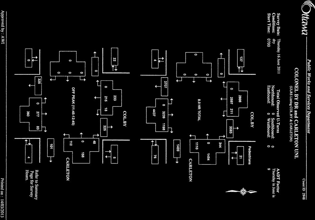
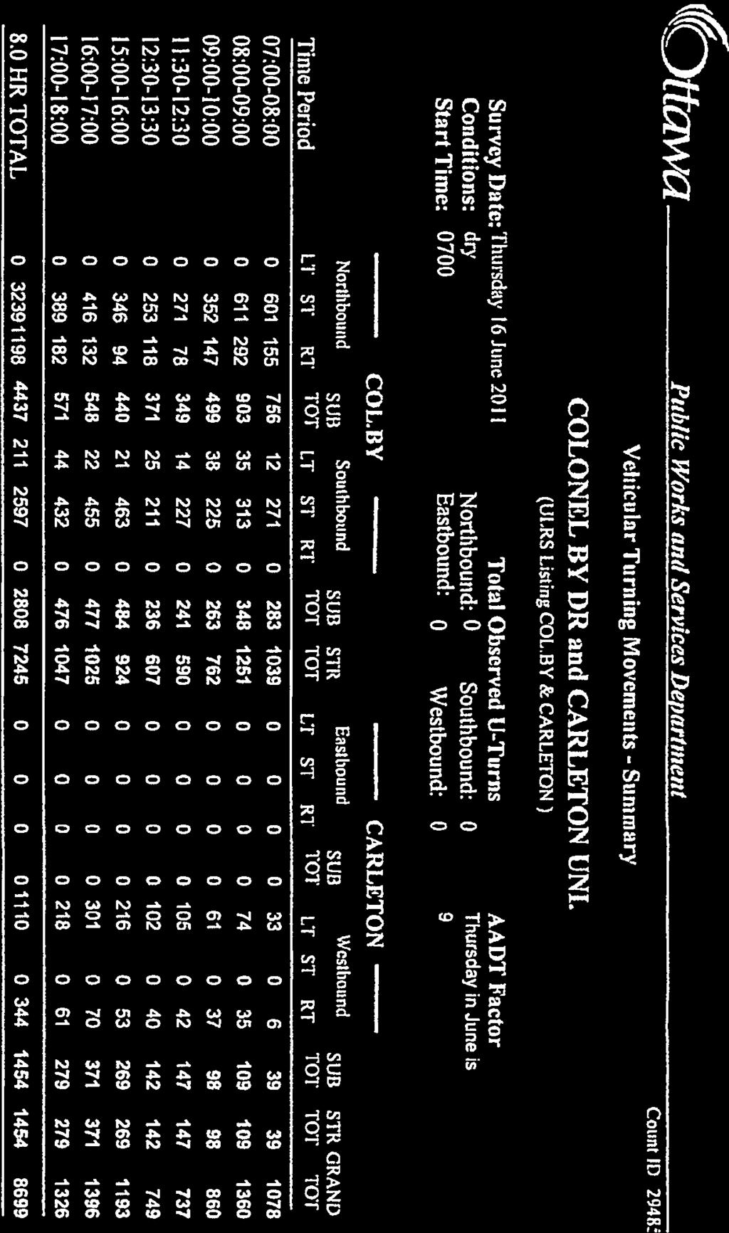
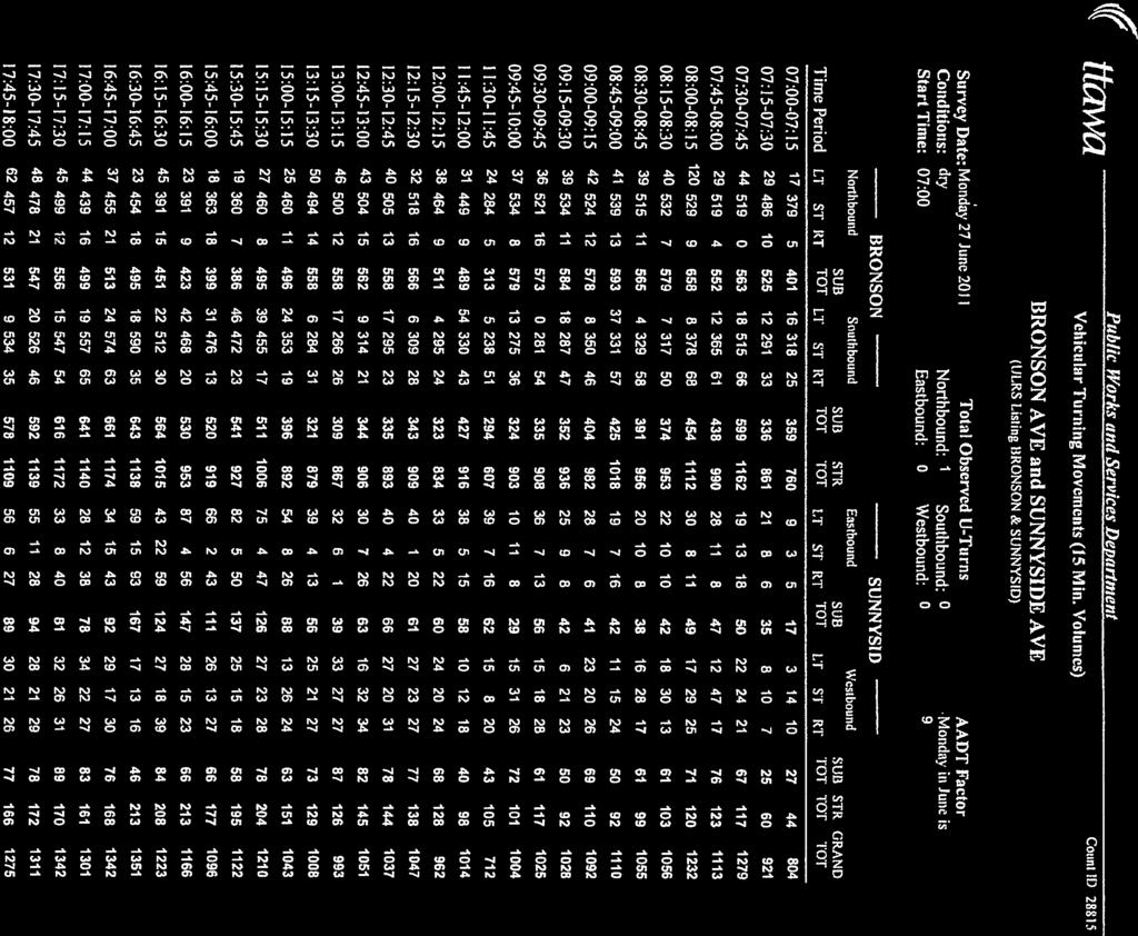
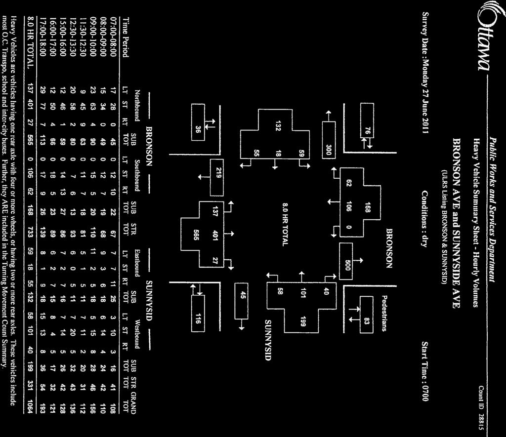
10 AECOM Carleton University Parking Lot P6C Transportation Impact Assessment Figure 4. Campus Map 3. Existing Conditions 3.1 Traffic Volumes The City of Ottawa provided traffic counts at the Colonel By Drive/University and Bronson/University intersections. Both counts were taken in June DRAFT RPT Traffic Impact Assessment.Doc 6
11 AECOM Carleton University Parking Lot P6C Transportation Impact Assessment We estimated the number of trips entering and exiting Carleton during the typical school year (September to April) using the Institute for Transportation Engineers (ITE) Trip General Manual (10 th Edition) and compared the estimate to the traffic data collected. The trip generation rates for the University land use and trips generated are summarized in Table 2. Using the University/College land use (Land use code 550), we can estimate trips generated using number of employees or number of students as our independent variable. The number of trips generated using students (21,500 full time, 4,500 part time) was higher than the number of trips generated using employees (1,900 employees). We selected the trips generated using employees as our independent variable because the manual noted that trip generation rates were generally lower at sites with transit service in close proximity. Carleton has both light rail and bus transit available on campus (Section 2.2). Also, there are 3,500 residence spaces on campus which reduces the number of students travelling to school and it is more typical of employees to own cars than for university students. For both peak hours, the regression equation was most appropriate. We estimated the distribution of trips based on the June 2011 traffic counts. Table 2. Carleton Trip Generation Peak Equation Entering Exiting University / College (550) Total Bronson Colonel By Total Bronson Colonel By AM T = 0.65(X) PM T = 0.61(X) The trips generated by using the ITE trip generation rates were fairly close to the traffic data volumes collected. The difference between the two values was within 10-20%. We used the trips calculated by the trip generation rates in our analyses. To be consistent with recent traffic studies in the area (Section 1.2), we applied an annual growth rate of 1% to the 2011 traffic volumes to determine the 2013 traffic volumes on Bronson Avenue and on Colonel By Drive. DRAFT RPT Traffic Impact Assessment.Doc 7
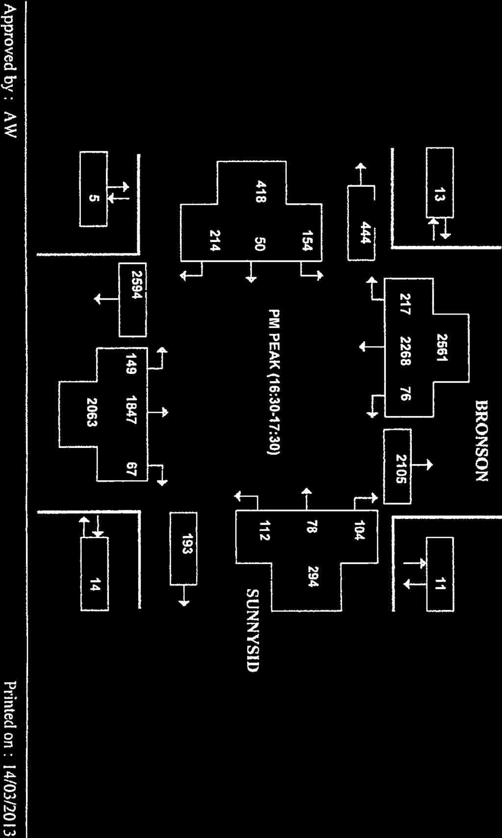
12 C Colonel By Drive University Drive (78) 291 (2313) (175) 78 (106) 154 (63) 120 (149) 51 (48) 57 (497) 70 (114) 277 (120) (68) (1884) Bronson Avenue 334 (524) 33 (26) 74 (55) 42 (242) (403) (127) University Drive km Local Roads O-Train Track Built-up Areas Vegetation Signalized Intersecion AM Volumes (PM Volumes) Carleton University Parking Lot PC6 Transportation Impact Study Figure 5 - Existing Traffic Volumes (2013) Datum: GCS NAD 1983 Projection: MTM9 Sources: City of Ottawa, GeoGratis, NRCan
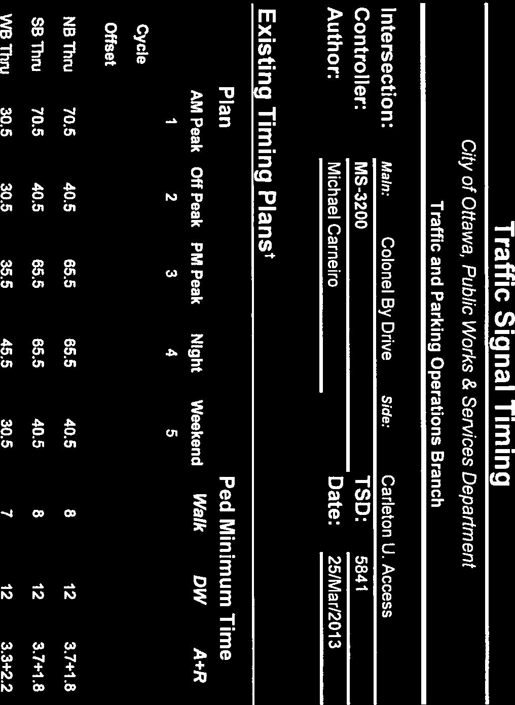
13 AECOM Carleton University Parking Lot P6C Transportation Impact Assessment 3.2 Traffic Operations Using Synchro version 8 with the Highway Capacity Manual 2010 (HCM) parameters, we analyzed the existing traffic operations at the University Drive/ Colonel By Drive intersection and at Bronson Avenue/ University Drive. Traffic signal timing plans were provided by the City of Ottawa. Table 3. Existing 2013 Baseline Traffic Operations University Drive Colonel By Drive Westbound Northbound Southbound Left Right Through Right Left Through AM v/c LOS C A A A A A PM v/c LOS D A A A A A University Drive Bronson Avenue Eastbound Westbound Northbound Southbound Left Through Right Left Through/Right Left Through/Right Left Through Right AM v/c LOS C A A A C E E E F A PM v/c LOS C A A A C D D C F A 4. Future Conditions 4.1 Future Projections Our baseline traffic volume projections are for the 2013 and 2018 time horizons. We selected 2013 because it is the anticipated build-out year for P6C and 2018 because it is build-out of the next stage of the project. The final stage of the project is anticipated for 30 years from now, in This horizon year is beyond the current planning horizon for the Ottawa Transportation Master Plan and therefore has not been considered in this report. Planning horizons greater than 20 years can be unpredictable and the assumptions can be very uncertain for that far into the future. The future traffic projections include existing traffic, background growth and the traffic from the new campus road and parking structure. In this instance, our existing traffic volumes (Section 3.1) are our baseline projections for Based on the Rideau Canal Multi-Use Crossing EA and the Lansdowne Revitalization TIS and TDM Plan, we have used a 5% background growth rate over 5 years to project future traffic. This is approximately 1% growth per year. We have carried this assumption throughout our analysis. DRAFT RPT Traffic Impact Assessment.Doc 9
14 AECOM Carleton University Parking Lot P6C Transportation Impact Assessment 4.2 Traffic Distribution and Assignment The parking structure will provide parking spaces for trips generated by Carleton and will not be a trip generator. It may be expected that drivers will shift from the open air parking areas at the north of the campus to the covered parking structure. Due to the construction of the parking garage, some of the existing parking spaces will be lost. The net increase in parking will be 520 new parking spaces. It is expected that only a portion of the new spaces will be used by current students and staff. The intention of the new parking structure is to plan for the future when new academic facilities will be constructed. It is at that time, at the 2043 horizon, that the new parking structure will be fully utilised. Since the parking lots at the north end of the campus are 86% filled at peak times, it not expected that the additional parking spaces will generate more traffic. A conservative estimate of 25% utilisation of the parking garage may be considered based on the current parking utilisation rates. During the AM peak hour, 27% of the current parking spaces are being filled by the traffic arriving on campus. Using the same filling rate and the expected usage of the parking garage, an additional 35 trips to the Carleton University campus is suggested for the AM peak hour. In the PM peak hour, 24% of the parking spaces are vacated. Therefore, 31 vehicles are expected to depart campus during the PM peak hour. The new access to Carleton University from Colonel By Drive will redistribute some trips already generated by Carleton University. We considered the existing traffic patterns at the Bronson Avenue and Colonel By Drive intersections and the location of the parking spaces on campus in order to assign trips to the new access at Colonel By Drive. 4.3 Total Traffic Volume The total traffic volume expected for 2013 once the parking garage has been completed is shown in Figure 6. By 2018, another 600 parking spaces are expected to be added to the parking structure. Although, no new university facilities are expected to be constructed during this time period, it may be possible that additional vehicles will use the parking garage. Using the same estimates for utilisation of the parking garage and filling rates during peak hours, it is assumed that an additional 40 vehicles will arrive at the parking garage in the AM peak hour and an additional 36 vehicles will depart from the parking garage during the PM peak hour. The traffic volumes for 2018 are shown in Figure 7. DRAFT RPT Traffic Impact Assessment.Doc 10
15 C 362 (540) 28 (10) 711 (450) Colonel By Drive 102 (111) 5 (44) 60 (10) University Drive (78) 279 (2313) (175) 78 (106) 159 (63) 72 (127) 51 (50) 57 (439) 70 (114) 286 (120) (68) (1884) Bronson Avenue 339 (568) 28 (16) 726 (479) 45 (47) 42 (206) 285 (51) University Drive km Local Roads O-Train Track Built-up Areas Vegetation Signalized Intersecion Unsignalized Intersection AM Volumes (PM Volumes) Carleton University Parking Lot PC6 Transportation Impact Study Figure 6 - Traffic Volumes at Buildout (2013) Datum: GCS NAD 1983 Projection: MTM9 Sources: City of Ottawa, GeoGratis, NRCan
16 C 375 (565) 29 (10) 732 (470) Colonel By Drive 102 (116) 5 (52) 72 (76) University Drive (81) 279 (2427) (175) 81 (111) 164 (63) 72 (127) 51 (52) 57 (455) 74 (120) 295 (120) (72) (1976) Bronson Avenue 352 (602) 28 (16) 759 (499) 45 (47) 42 (206) 285 (51) University Drive km Local Roads O-Train Track Built-up Areas Vegetation Signalized Intersecion Unsignalized Intersection AM Volumes (PM Volumes) Carleton University Parking Lot PC6 Transportation Impact Study Figure 7 - Traffic Volumes (2018) Datum: GCS NAD 1983 Projection: MTM9 Sources: City of Ottawa, GeoGratis, NRCan
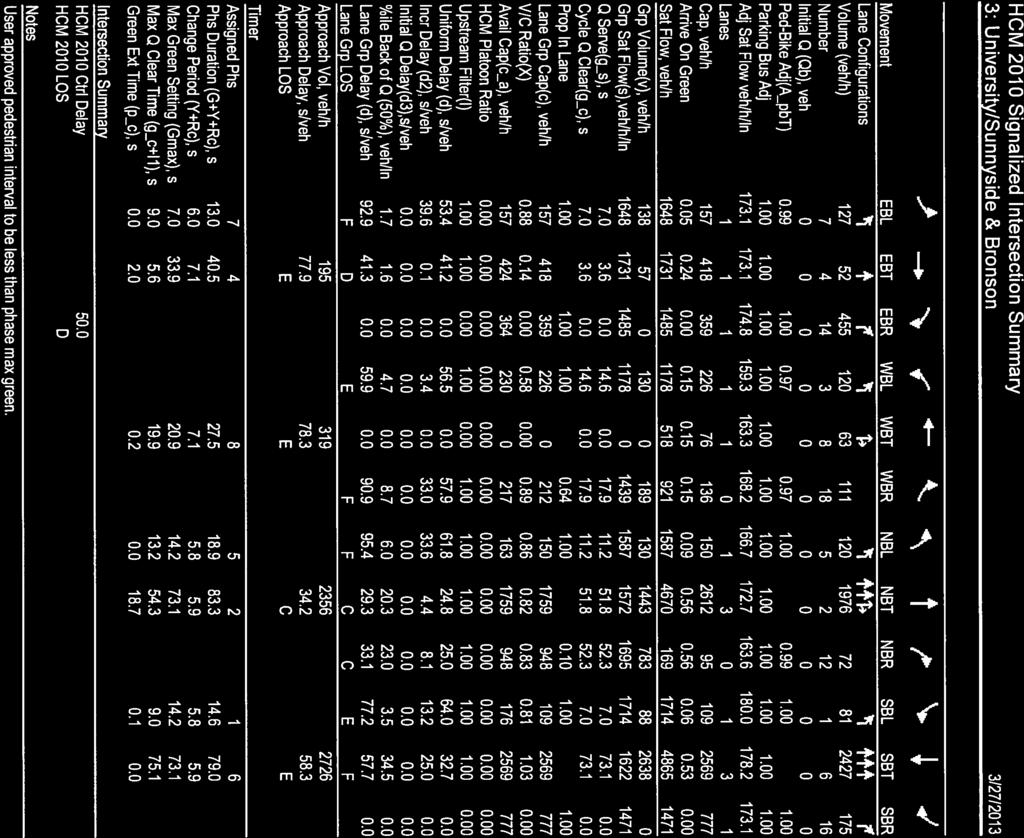
17 AECOM Carleton University Parking Lot P6C Transportation Impact Assessment 4.4 Traffic Control and Geometric Requirements With the low traffic volumes expected at the parking lot entrance on Colonel By Drive, stop control at the new access location for the minor leg will be appropriate. A single lane entry and exit is suggested for the new access road. The existing lanes on Colonel By Drive should be a shared through/left in the southbound direction and a shared through/right in the northbound direction. 4.5 Future Traffic Operations Using Synchro version 8 with the Highway Capacity Manual 2010 (HCM) parameters, we analyzed the 2013 traffic operations at three intersections once Parking Lot P6C is completed. The signalized intersections we analyzed included University Drive/ Colonel By and Bronson Avenue/ University Drive. We also analyzed traffic at the new stop controlled intersection on Colonel By at the north end of campus. Table Buildout Traffic Operations University Drive Colonel By Drive Westbound Northbound Southbound Left Right Through Right Left Through AM v/c LOS C A A A A A PM v/c LOS D A A A A A University Drive Bronson Avenue Eastbound Westbound Northbound Southbound Left Through Right Left Through/Right Left Through/Right Left Through Right AM v/c LOS A A A A D E D C E A PM v/c LOS C A A A D D C C F A New Road Colonel By Drive Westbound Northbound Southbound AM v/c LOS A - - PM v/c LOS A - - The results of the analysis indicate that the additional trips from the parking garage and the redistribution of some trips to alternate intersections have little impact on overall intersection operations. There are some movements that DRAFT RPT Traffic Impact Assessment.Doc 13
18 AECOM Carleton University Parking Lot P6C Transportation Impact Assessment have an improvement in v/c ratio with the addition of the new access location due to the redistribution of trips. There are other movements that have an increased v/c ratio due to the additional trips. The changes to the v/c ratios due to the parking garage construction are minor. Using Synchro version 8 with the Highway Capacity Manual 2010 (HCM) parameters, we analyzed the 2018 future traffic operations at the signalized intersections of University Drive/ Colonel By and Bronson Avenue/ University Drive. We also analyzed traffic at the new stop controlled intersection on Colonel By at the north end of campus. Table Traffic Operations University Drive Colonel By Drive Westbound Northbound Southbound Left Right Through Right Left Through AM v/c LOS C A A A A A PM v/c LOS D A A A A A University Drive Bronson Avenue Eastbound Westbound Northbound Southbound Left Through Right Left Through/Right Left Through/Right Left Through Right AM v/c LOS A A A A D E E C F A PM v/c LOS D A A A D D D D F A New Road Colonel By Drive Westbound Northbound Southbound AM v/c LOS A - - PM v/c LOS A - - The results of the analysis indicate that the additional trips from the parking garage and the redistribution of some trips to alternate intersections have little impact on overall intersection operations. There are some movements that have an improvement in v/c ratio with the addition of the new access location due to the redistribution of trips. There are other movements that have an increased v/c ratio due to the additional trips. The changes to the v/c ratios due to the parking garage construction are minor. DRAFT RPT Traffic Impact Assessment.Doc 14
19 AECOM Carleton University Parking Lot P6C Transportation Impact Assessment 5. Conclusions and Recommendations The new parking structure at the Carleton University campus will generate few new trips since the existing parking lots are not currently used to full capacity. The new garage is being built for future expansion of the campus planned for a 30 year horizon. Some existing trips will be redistributed on the road network and some new trips will also be generated. A new intersection will be created on Colonel By Drive at the location of the access road to the parking structure. Stop control for the access driveway is the recommended traffic control at this intersection. No additional lanes are required on Colonel By Drive and the existing lanes are recommended to be shared through/left and through/right lanes. The additional traffic has little impact on the intersections on Colonel By Drive/ University Drive and Bronson Avenue/ University Drive. The levels of service related to the v/c ratios remain the same as for the existing condition. Some traffic signal timing modifications may be required at the 2018 horizon period but any changes are related to the background of traffic volumes on Bronson Avenue rather than new traffic related to the parking structure. DRAFT RPT Traffic Impact Assessment.Doc 15

20
21
22
23

24
25
26
27
28
29
30

31
32
33
34
35
36
37
HENDERSON DEVELOPMENT 213, 217, 221, 221 ½, 223 HENDERSON AVENUE and 65 TEMPLETON STREET OTTAWA, ONTARIO TRANSPORTATION OVERVIEW.
 HENDERSON DEVELOPMENT 213, 217, 221, 221 ½, 223 HENDERSON AVENUE and 65 TEMPLETON STREET OTTAWA, ONTARIO TRANSPORTATION OVERVIEW Prepared for: 2294170 Ontario Inc. February 2, 2017 117-652 Report_1.doc
INDUSTRIAL BUILDING 3009 HAWTHORNE ROAD CITY OF OTTAWA TRANSPORTATION OVERVIEW REVISED. Prepared for: Canada Inc.
 INDUSTRIAL BUILDING 3009 HAWTHORNE ROAD CITY OF OTTAWA TRANSPORTATION OVERVIEW REVISED Prepared for: 7849648 Canada Inc. Octiober 1, 2015 114-598 Overview_2.doc D. J. Halpenny & Associates Ltd. Consulting
MEDICAL/OFFICE BUILDING 1637 BANK STREET OTTAWA, ONTARIO TRANSPORTATION OVERVIEW. Prepared for:
 MEDICAL/OFFICE BUILDING 1637 BANK STREET OTTAWA, ONTARIO TRANSPORTATION OVERVIEW Prepared for: 2434984 Ontario Inc. 13-5510 Canotek Road Ottawa, Ontario K1J 9J5 June 4, 2015 115-613 Report_2.doc D. J.
OTTAWA TRAIN YARDS PHASE 3 DEVELOPMENT CITY OF OTTAWA TRANSPORTATION IMPACT STUDY. Prepared for:
 OTTAWA TRAIN YARDS PHASE 3 DEVELOPMENT CITY OF OTTAWA TRANSPORTATION IMPACT STUDY Prepared for: The Ottawa Train Yards Inc. 223 Colonnade Road South, Suite 212 Nepean, Ontario K2E 7K3 January 17, 2012
INDUSTRIAL BUILDING 1660 COMSTOCK ROAD CITY OF OTTAWA TRANSPORTATION OVERVIEW. Prepared for:
 INDUSTRIAL BUILDING 1660 COMSTOCK ROAD CITY OF OTTAWA TRANSPORTATION OVERVIEW Prepared for: Simluc Contractors Limited 2550 Blackwell Street, Ottawa K1B 5R1 October 18, 2013 113-584 Overview_1.doc D. J.
OFFICE/RETAIL DEVELOPMENT 1625 BANK STREET OTTAWA, ONTARIO TRANSPORTATION BRIEF. Prepared for: Canada Inc.
 OFFICE/RETAIL DEVELOPMENT 1625 BANK STREET OTTAWA, ONTARIO TRANSPORTATION BRIEF Prepared for: 9402209 Canada Inc. December 15, 2015 115-625 Report_2.doc D. J. Halpenny & Associates Ltd. Consulting Transportation
HOLIDAY INN HOTEL 235 KING EDWARD AVENUE CITY OF OTTAWA TRANSPORTATION BRIEF. Prepared for:
 HOLIDAY INN HOTEL 235 KING EDWARD AVENUE CITY OF OTTAWA TRANSPORTATION BRIEF Prepared for: Momentum Planning & Communications 1165 Greenlawn Crescent Ottawa, ON K1L 6C2 June 29, 2015 115-618 Brief_1.doc
MEETING FACILITY 2901 GIBFORD DRIVE CITY OF OTTAWA TRANSPORTATION BRIEF. Prepared for: Holiday Inn Express 2881 Gibford Drive Ottawa, ON K1V 2L9
 MEETING FACILITY 2901 GIBFORD DRIVE CITY OF OTTAWA TRANSPORTATION BRIEF Prepared for: Holiday Inn Express 2881 Gibford Drive Ottawa, ON K1V 2L9 December 18, 2012 112-566 Brief_1.doc D. J. Halpenny & Associates
URBAN QUARRY HEADQUARTERS 2717 STEVENAGE DRIVE CITY OF OTTAWA TRANSPORTATION OVERVIEW. Prepared for: Urban Quarry 4123 Belgreen Drive, Ottawa K1G 3N2
 URBAN QUARRY HEADQUARTERS 2717 STEVENAGE DRIVE CITY OF OTTAWA TRANSPORTATION OVERVIEW Prepared for: Urban Quarry 4123 Belgreen Drive, Ottawa K1G 3N2 February 27, 2014 113-584 Overview_1.doc D. J. Halpenny
QUICKIE C STORE AND GAS BAR 1780 HERON ROAD OTTAWA, ONTARIO TRANSPORTATION BRIEF. Prepared for:
 QUICKIE C STORE AND GAS BAR 1780 HERON ROAD OTTAWA, ONTARIO TRANSPORTATION BRIEF Prepared for: Quickie Convenience Stores Larny Holdings Ltd. c/o PBC Group April 15, 2015 115-615 Report_1.doc D. J. Halpenny
HILTON GARDEN INN HOTEL HOTEL EXPANSION 2400 ALERT ROAD, OTTAWA TRANSPORTATION BRIEF. Prepared for:
 HILTON GARDEN INN HOTEL HOTEL EXPANSION 2400 ALERT ROAD, OTTAWA TRANSPORTATION BRIEF Prepared for: Bona Building & Management Co. Ltd. Place Vanier, 333 North River Road Vanier, Ontario K1L 8B9 October
NEW YORK CENTRAL PARK SUBDIVISION BLAIS STREET/ST-PIERRE STREET EMBRUN, ONTARIO TRAFFIC IMPACT STUDY. Prepared for:
 NEW YORK CENTRAL PARK SUBDIVISION BLAIS STREET/ST-PIERRE STREET EMBRUN, ONTARIO TRAFFIC IMPACT STUDY Prepared for: Solidex Holdings Limited & Investissement Maurice Lemieux Investments Attn: Mr. Anthony
Transportation Impact Study for Abington Terrace
 Transportation Impact Study for Abington Terrace Abington Township, Montgomery County, PA Sandy A. Koza, P.E., PTOE PA PE License Number PE059911 Prepared by McMahon Associates, Inc. 425 Commerce Drive,
TRANSPORTATION ANALYSIS REPORT US Route 6 Huron, Erie County, Ohio
 TRANSPORTATION ANALYSIS REPORT US Route 6 Huron, Erie County, Ohio December 12, 2012 Prepared for: The City of Huron 417 Main Huron, OH 44839 Providing Practical Experience Technical Excellence and Client
Harrah s Station Square Casino
 Transportation Analysis Harrah s Station Square Casino Pittsburgh, Pennsylvania Submitted To: City of Pittsburgh and Pennsylvania Gaming Control Board Prepared By: DKS Associates GAI Consultants December
COMMERCIAL DEVELOPMENT 2015 ROBERTSON ROAD OTTAWA, ONTARIO TRANSPORTATION BRIEF. Prepared for:
 COMMERCIAL DEVELOPMENT 2015 ROBERTSON ROAD OTTAWA, ONTARIO TRANSPORTATION BRIEF Prepared for: First Bay Properties Inc. 311 Richmond Road, Suite 203 Ottawa, ON K1Z 6X3 August 8, 2017 117-663 Brief_1.doc
Traffic Impact Study WestBranch Residential Development Davidson, NC March 2016
 Traffic Impact Study WestBranch Residential Development Davidson, NC March 216 TRAFFIC IMPACT STUDY FOR THE WestBranch Residential Development LOCATED IN DAVIDSON, NC Prepared For: Lennar Carolinas, LLC
Project Report. South Kirkwood Road Traffic Study. Meadows Place, TX October 9, 2015
 Meadows Place, TX October 9, 2015 Contents 1 Introduction... 1 2 Data Collection... 1 3 Existing Roadway Network... 2 4 Traffic Volume Development... 2 5 Warrant Analysis... 3 6 Traffic Control Alternative
FAIRFIELD INN & SUITES HOTEL 135 THAD JOHNSON PRIVATE OTTAWA TRANSPORTATION BRIEF. Prepared for:
 FAIRFIELD INN & SUITES HOTEL 135 THAD JOHNSON PRIVATE OTTAWA TRANSPORTATION BRIEF Prepared for: Bona Building & Management Co. Ltd. Place Vanier, 333 North River Road Vanier, Ontario K1L 8B9 August 12,
TRAFFIC ASSESSMENT River Edge Colorado
 TRAFFIC ASSESSMENT River Edge Colorado Submitted by: Fehr & Peers 621 17th Street, Ste. 231 Denver, CO 8293 (33) 296-43 December, 21 App. M-2 Traffic Assessment River Edge Colorado December 21 TABLE OF
Magnolia Place. Traffic Impact Analysis. Prepared for: City of San Mateo. Prepared by: Hexagon Transportation Consultants, Inc.
 Magnolia Place Traffic Impact Analysis Prepared for: City of San Mateo Prepared by: Hexagon Transportation Consultants, Inc. Updated January 4, 2010 Table of Contents 1. Introduction...1 2. Existing Conditions...6
84-88 Columbia Street West Waterloo, Ontario Transportation Impact Study. Paradigm Transportation Solutions Limited
 84-88 Columbia Street West Waterloo, Ontario Transportation Impact Study Paradigm Transportation Solutions Limited June 217 Project Summary Project Number 15255 June 217 Client Masri O Inc. Architects
5858 N COLLEGE, LLC N College Avenue Traffic Impact Study
 5858 N COLLEGE, LLC nue Traffic Impact Study August 22, 2016 Contents Traffic Impact Study Page Preparer Qualifications... 1 Introduction... 2 Existing Roadway Conditions... 5 Existing Traffic Conditions...
THIS PAGE LEFT BLANK INTENTIONALLY
 GA SR 25 Spur at Canal Road Transportation Impact Analysis PREPARED FOR GLYNN COUNTY, GEORGIA 1725 Reynolds Street, Suite 300 Brunswick, Georgia 31520 PREPARED BY 217 Arrowhead Boulevard Suite 26 Jonesboro,
Highway 111 Corridor Study
 Highway 111 Corridor Study June, 2009 LINCOLN CO. HWY 111 CORRIDOR STUDY Draft Study Tea, South Dakota Prepared for City of Tea Sioux Falls Metropolitan Planning Organization Prepared by HDR Engineering,
METHODOLOGY. Signalized Intersection Average Control Delay (sec/veh)
") Chapter 5 Traffic Analysis 5.1 SUMMARY US /West 6 th Street assumes a unique role in the Lawrence Douglas County transportation system. This principal arterial street currently conveys commuter traffic
Chapter 5 Traffic Analysis 5.1 SUMMARY US /West 6 th Street assumes a unique role in the Lawrence Douglas County transportation system. This principal arterial street currently conveys commuter traffic
List of Attachments. Location Map... Site Plan... City of Lake Elsinore Circulation Element... City of Lake Elsinore Roadway Cross-Sections...
 List of Attachments Exhibits Location Map... Site Plan... City of Lake Elsinore Circulation Element... City of Lake Elsinore Roadway Cross-Sections... Existing Lane Geometry and Traffic Controls... Existing
TRAFFIC IMPACT ANALYSIS
 TRAFFIC IMPACT ANALYSIS FOR THE CHAMPAIGN UNIT#4 SCHOOL DISTRICT PROPOSED HIGH SCHOOL (SPALDING PARK SITE) IN THE CITY OF CHAMPAIGN Final Report Champaign Urbana Urbanized Area Transportation Study 6/24/2014
APARTMENT BUILDING DEVELOPMENT 1161 HERON ROAD OTTAWA, ONTARIO TRANSPORTATION IMPACT STUDY. Prepared for:
 APARTMENT BUILDING DEVELOPMENT 1161 HERON ROAD OTTAWA, ONTARIO TRANSPORTATION IMPACT STUDY Prepared for: 1649362 Ontario Inc. c/o Manor Park Management 231 Brittany Drive, Suite D Ottawa ON K1K 0R8 July
BLUE SEA VILLAGE MER BLEUE 2159 MER BLEUE ROAD OTTAWA, ONTARIO TRANSPORTATION IMPACT ASSESSMENT. Prepared for: Ontario Limited.
 BLUE SEA VILLAGE MER BLEUE 2159 MER BLEUE ROAD OTTAWA, ONTARIO TRANSPORTATION IMPACT ASSESSMENT Prepared for: 2534189 Ontario Limited April 6, 2018 117-668 TIA Report_2.doc D. J. Halpenny & Associates
TRAFFIC IMPACT STUDY CRITERIA
 Chapter 6 - TRAFFIC IMPACT STUDY CRITERIA 6.1 GENERAL PROVISIONS 6.1.1. Purpose: The purpose of this document is to outline a standard format for preparing a traffic impact study in the City of Steamboat
Traffic Impact Analysis Walton Acres at Riverwood Athletic Club Clayton, NC
 Traffic Impact Analysis Walton Acres at Riverwood Athletic Club Clayton, NC 1. TABLE OF CONTENTS INTRODUCTION...1 1.1. Site Location and Study Area...1 1.2. Proposed Land Use and Site Access...2 1.3.
Traffic Impact Study. Westlake Elementary School Westlake, Ohio. TMS Engineers, Inc. June 5, 2017
 TMS Engineers, Inc. Traffic Impact Study Westlake Elementary School Westlake, Ohio June 5, 2017 Prepared for: Westlake City Schools - Board of Education 27200 Hilliard Boulevard Westlake, OH 44145 TRAFFIC
9 Leeming Drive Redevelopment Ottawa, ON Transportation Brief. Prepared By: Stantec Consulting Ltd.
 9 Leeming Drive Redevelopment Ottawa, ON Transportation Brief Prepared By: Stantec Consulting Ltd. TIA GUIDELINES CHECKLIST Report Context Municipal Address Comment: Section 1.1 Location relative to major
TRAFFIC IMPACT STUDY And A TRAFFIC SIGNAL WARRANT ANALYSIS FOR A SENIOR LIVING AND APARTMENT DEVELOPMENT
 TRAFFIC IMPACT STUDY And A TRAFFIC SIGNAL WARRANT ANALYSIS FOR A SENIOR LIVING AND APARTMENT DEVELOPMENT DEERFIELD TOWNSHIP, WARREN COUNTY, OHIO Nantucket Circle and Montgomery Road () Prepared for: ODLE
Chapter 16: Traffic and Parking A. INTRODUCTION
 Chapter 6: Traffic and Parking A. ITRODUCTIO This chapter examines the potential traffic and parking impacts of the proposed Fresh Kills Park roads. The analysis of transit and pedestrians is presented
AMEC Earth and Environmental. Bovaird Drive Environmental Assessment. Traffic Study Final Report. August Excellence in Transportation Planning
 AMEC Earth and Environmental Bovaird Drive Environmental Assessment Traffic Study Final Report August Excellence in Transportation Planning AMEC Earth and Environmental Bovaird Drive Class EA Traffic
4. ENVIRONMENTAL IMPACT ANALYSIS 9. TRANSPORTATION AND TRAFFIC
 4. ENVIRONMENTAL IMPACT ANALYSIS 9. TRANSPORTATION AND TRAFFIC 4.9.1 INTRODUCTION The following section addresses the Proposed Project s impact on transportation and traffic based on the Traffic Study
Low Level Road Improvements Traffic Analysis. Report
 Low Level Road Improvements Traffic Analysis Report June, 22 Table of Contents. INTRODUCTION.... LOW LEVEL ROAD PROJECT....2 STUDY AREA....2. West-End Corridor Improvements... 2.2.2 East-End Corridor Improvements...
Traffic Circulation Study for Neighborhood Southwest of Mockingbird Lane and Airline Road, Highland Park, Texas
 ARIZONA TEXAS NEW MEXICO OKLAHOMA February 13, 2015 Mr. Meran Dadgostar P.E., R.S. Town of Highland Park 4700 Drexel Dr. Highland Park, Texas 75205 Re: Traffic Circulation Study for Neighborhood Southwest
Traffic Impact Analysis Chatham County Grocery Chatham County, NC
 Chatham County Grocery Chatham County, NC TABLE OF CONTENTS 1. INTRODUCTION... 1 1.1. Location and Study Area... 1 1.2. Proposed Land Use and Access... 2 1.3. Adjacent Land Uses... 2 1.4. Existing ways...
TRAFFIC STUDY GUIDELINES Clarksville Street Department
 TRAFFIC STUDY GUIDELINES Clarksville Street Department 9/1/2009 Introduction Traffic studies are used to help the city determine potential impacts to the operation of the surrounding roadway network. Two
VIVA RETIREMENT COMMUNITIES OAKVILLE TRAFFIC IMPACT STUDY
 VIVA RETIREMENT COMMUNITIES OAKVILLE TRAFFIC IMPACT STUDY VIVA RETIREMENT COMMUNITIES OAKVILLE TRAFFIC IMPACT STUDY DECEMBER 2012 READ, VOORHEES & ASSOCIATES TORONTO, ONTARIO Read, Voorhees & Associates
Chapter 4 Traffic Analysis
 Chapter 4 Traffic Analysis PURPOSE The traffic analysis component of the K-68 Corridor Management Plan incorporates information on the existing transportation network, such as traffic volumes and intersection
St. Stefan Serbian Orthodox Church 1989 and 1993 Prince of Wales Drive, Ottawa REVISED TRANSPORTATION BRIEF
 St. Stefan Serbian Orthodox Church 1989 and 1993 Prince of Wales Drive, Ottawa REVISED TRANSPORTATION BRIEF Prepared By: NOVATECH ENGINEERING CONSULTANTS LTD. Suite 200, 240 Michael Cowpland Drive Ottawa,
South Albion-Bolton Community Plan North Hill Supermarket Transportation Study Part B: Evaluation of Alternatives
 Community Plan North Hill Supermarket Transportation Study Part B: Evaluation of Alternatives Prepared for: The Town of Caledon August 9 Transportation Solutions Ltd. 43 Forest Road Cambridge, ON N1S 3B4
Walmart (Store # ) 60 th Street North and Marion Road Sioux Falls, South Dakota
 60 th Street North and Marion Road Sioux Falls, South Dakota") Walmart (Store #4865-00) 60 th Street North and Marion Road Sioux Falls, South Dakota Prepared for: Wal-Mart Stores, Inc. Bentonville, Arkansas Prepared by: Kimley-Horn and Associates, Inc. ã2013 Kimley-Horn
Walmart (Store #4865-00) 60 th Street North and Marion Road Sioux Falls, South Dakota Prepared for: Wal-Mart Stores, Inc. Bentonville, Arkansas Prepared by: Kimley-Horn and Associates, Inc. ã2013 Kimley-Horn
Corporation of the Town of Oakville. December 16, 2013
 Corporation of the Town of Oakville Transportation Impact Analysis and Parking Study for Proposed Secondary School, Oakville Draft Final Report Submitted by: HDR Corporation 100 York Boulevard, Suite 300
Subject: Solberg Avenue / I-229 Grade Separation: Traffic Analysis
 MEMORANDUM Transportation Bill Troe, AICP Jason Carbee, AICP 12120 Shamrock Plaza Suite 300 Omaha, NE 68154 (402) 334-8181 (402) 334-1984 (Fax) To: Project File Date: Subject: Solberg Avenue / I-229 Grade
Traffic Impact Study Little Egypt Road Development Denver, North Carolina June 2017
 Traffic Impact Study Little Egypt Road Development Denver, North arolina June 2017 N. Little Egypt Road DQ\ QDQFLQJ VDOHV RU RWKHU SHUIRUPDQFH EDVHG FULWHULD Proposed Site Driveways Site Driveway 1 TRAFFI
TABLE OF CONTENTS TABLE OF CONTENTS... I APPENDICES... III LIST OF EXHIBITS... V LIST OF TABLES... VII LIST OF ABBREVIATED TERMS...
 TABLE OF CONTENTS TABLE OF CONTENTS... I APPENDICES... III LIST OF EXHIBITS... V LIST OF TABLES... VII LIST OF ABBREVIATED TERMS... IX 1 INTRODUCTION... 1 1.1 Project Overview... 1 1.2 Analysis Scenarios...
Bistro 6. City of Barrie. Traffic Impact Study for Pratt Hansen Group Inc. Type of Document: Final Report. Project Number: JDE 1748
 City of Barrie Traffic Impact Study for Pratt Hansen Group Inc. Type of Document: Final Report Project Number: JDE 1748 Date Submitted: June 12 th, 2017 06/12/17 John Northcote, P.Eng. Professional License
Glenn Avenue Corridor Traffic Operational Evaluation
 Glenn Avenue Corridor Traffic Operational Evaluation PREPARED FOR: THE CITY OF AUBURN PREPARED BY: DECEMBER 2007 Glenn Avenue Corridor Study--Auburn, Alabama TABLE OF CONTENTS Introduction... 1 Background
TRAFFIC IMPACT STUDY COMPREHENSIVE UPDATE TOWN OF THOMPSON S STATION, TENNESSEE PREPARED FOR: THE TOWN OF THOMPSON S STATION
 TRAFFIC IMPACT STUDY COMPREHENSIVE UPDATE TOWN OF THOMPSON S STATION, TENNESSEE PREPARED FOR: THE TOWN OF THOMPSON S STATION Transportation Consultants, LLC 1101 17 TH AVENUE SOUTH NASHVILLE, TN 37212
Having held a public hearing, that Council approve:
 3. MODIFICATIONS TO MERIVALE ROAD FROM FALLOWFIELD ROAD TO OLD HIGHWAY 16 TO ACCOMMODATE THE GROWTH WITHIN THE SOUTH MERIVALE BUSINESS PARK - PUBLIC HEARING COMMITTEE RECOMMENDATIONS Having held a public
CPC Parking Lot Riverside Drive. Transportation Brief
 CPC Parking Lot 2785 Riverside Drive Transportation Brief Prepared By: NOVATECH Suite 2, 24 Michael Cowpland Drive Ottawa, Ontario K2M P6 7 / 5 / 25 Novatech File: 49 Ref: R-25-22 July 5 th, 25 City of
Appendix C. NORTH METRO STATION AREA TRAFFIC IMPACT STATEMENT 88th Avenue Station
 Appendix C NORTH METRO STATION AREA TRAFFIC IMPACT STATEMENT 88th Avenue Station Prepared for: Regional Transportation Department and URS Corporation as part of the North Metro EIS David Evans and Associates,
DUNBOW ROAD FUNCTIONAL PLANNING
 DUNBOW ROAD FUNCTIONAL PLANNING Final Report August 3, 216 #31, 316 5th Avenue NE Calgary, AB T2A 6K4 Phone: 43.273.91 Fax: 43.273.344 wattconsultinggroup.com Dunbow Road Functional Planning Final Report
Appendix B: Forecasting and Traffic Operations Analysis Framework Document
 Existing Conditions Report - Appendix Appendix B: Forecasting and Traffic Operations Analysis Framework Document This document defines the methodology and assumptions that will be used in the traffic forecasting
The proposed development is located within 800m of an existing Transit Station where infill developments and intensification are encouraged.
 Stantec Consulting Ltd. 1331 Clyde Avenue, Suite 4 Ottawa ON K2C 3G4 Tel: (613) 722-442 Fax: (613) 722-2799 May 14, 213 File: 1638823 Robinson Park Development Corp. 5699 Power Road Ottawa, ON, K1G 3N4
Henderson Avenue Mixed-Use Development
 Zoning Case: Z145-3 Traffic Impact Analysis Henderson Avenue Mixed-Use Development Dallas, TX October 26 th, 216 Kimley-Horn and Associates, Inc. Dallas, Texas Project #644827 Registered Firm F-928 Traffic
Walton Acres at Riverwood Athletic Club Clayton, North Carolina
 9. CONCLUSIONS This Traffic Impact Analysis Update was conducted to determine the potential traffic impacts of the proposed Walton Acres at Riverwood Athletic Club residential development, located east
Troutbeck Farm Development
 Troutbeck Farm Development Willistown Township, Chester County PA For Submission To: Willistown Township Last Revised: October, 4 TPD# INLM.A. 5 E. High Street Suite 65 Pottstown, PA 9464 6.36.3 TPD@TrafficPD.com
1609 E. FRANKLIN STREET HOTEL TRAFFIC IMPACT STUDY EXECUTIVE SUMMARY
 1609 E. FRANKLIN STREET HOTEL TRAFFIC IMPACT STUDY EXECUTIVE SUMMARY Prepared for: The Town of Chapel Hill Public Works Department Traffic Engineering Division Prepared by: HNTB North Carolina, PC 343
MEMORANDUM. Trip Generation and Distribution. CyRide / ISU Intermodal Facility Steering Committee. Date: August 31, 2009
 MEMORANDUM Transportation Jim Kollbaum, PE 12120 Shamrock Plaza Suite 300 Omaha, NE 68154 (402) 334-8181 (402) 334-1984 (Fax) To: CyRide / ISU Intermodal Facility Steering Committee Date: August 31, 2009
Table of Contents FIGURES TABLES APPENDICES. Traffic Impact Study Hudson Street Parking Garage MC Project No.: A Table of Contents
 Traffic Impact Study Hudson Street Parking Garage MC Project No.: 151714A Table of Contents Table of Contents I. INTRODUCTION... 2 II. EXISTING CONDITIONS... 5 III. 215 EXISTING TRAFFIC CONDITIONS... 6
CPC Parking Lot Riverside Drive. Transportation Rationale
 CPC Parking Lot Transportation Rationale Prepared By: NOVATECH Suite 200, 240 Michael Cowpland Drive Ottawa, Ontario K2M 1P6 September 2015 Novatech File: 114093 Ref: R-2015-153 Table of Contents 1.0 INTRODUCTION...
Capital Region Council of Governments
 March 23, 2018 Capital Region Council of Governments PROJECT CONCEPT REPORT Realignment of Swamp and Northfield Road s approaches to Route 44 (Boston Turnpike) Town of Coventry SUMMARY: The Town of Coventry
Paul VI Redevelopment. Traffic Impact Study
 ATTACHMENT 5 Paul VI Redevelopment Traffic Impact Study April 18, 2017 PAUL VI REDEVELOPMENT TRAFFIC IMPACT STUDY CITY OF FAIRFAX, VIRGINIA Prepared for: IDI GROUP COMPANIES Prepared by: Wells + Associates,
Draft Report. Traffic Impact Study. Superstore, Wal-Mart, and Kent Development. Yarmouth, Nova Scotia. Prepared for
 oad & Traffic Management Road & Traffic Management R Atlantic Traffic Engineering Specialists Draft Report Traffic Impact Study Superstore, Wal-Mart, and Kent Development Yarmouth, Nova Scotia Prepared
Rideau Canal Corridor Pedestrian Crossing Study. Queen Elizabeth Dr.: Preston St. to Laurier Ave. & Colonel By Drive: Hog s Back to Daly Ave.
 Rideau Canal Corridor Pedestrian Crossing Study Queen Elizabeth Dr.: Preston St. to Laurier Ave. & Colonel By Drive: Hog s Back to Daly Ave. Background: Canal parkways evolved over past 100 years Today
3.9 - Transportation and Traffic
 Transportation and Traffic 3.9 - Transportation and Traffic This section describes the potential transportation and traffic effects of project implementation on the project site and its surrounding area.
Appendix B Transportation Report
 Project File Report Appendix B Transportation Report Town of Whitby HMM Project No. 327878 Final Report October 2014 Revision and Version Tracking CP Rail Crossing at New Coronation Road Class EA Study
Figure 1: East West Connector Alignment Alternatives Concept Drawing
 Page 2 of 9 Figure 1: East West Connector Alignment Alternatives Concept Drawing The Montebello Drive extension will run north south and connect Wilsonville Road to the Boones Ferry Road to Brown Road
Donahue Drive Corridor Traffic Operational Evaluation
 Donahue Drive Corridor Traffic Operational Evaluation PREPARED FOR: THE CITY OF AUBURN PREPARED BY: JANUARY 2007 Donahue Drive Corridor Study--Auburn, Alabama TABLE OF CONTENTS Introduction... 1 Background
Operational Comparison of Transit Signal Priority Strategies
 Operational Comparison of Transit Signal Priority Strategies Revision Submitted on: November, 0 Author: Adriana Rodriguez, E.I Assistant Engineer Parsons Brinckerhoff 0 South Orange Avenue, Suite 00 Orlando,
CITY OF OTTAWA ROADWAY MODIFICATION APPROVAL UNDER DELEGATED AUTHORITY
 RMA-2015-ATM-038 CITY OF OTTAWA ROADWAY MODIFICATION APPROVAL UNDER DELEGATED AUTHORITY DATE: April 22, 2015 SUBJECT Approval of Roadway Modifications Recommended through an Area Traffic Management Study
19 July 2016 OUR REF:
 19 July 2016 OUR REF: 602263-01000 194168 Ontario Ltd. 320 McRae Street Ottawa, ON K1Z 5R8 Attention: Brian Casagrande Dear Brian: Re: 320 McRae/1976 Scott Redevelopment CTS Addendum #1 This Addendum has
2136 And 2148 Trafalgar Road Townhouse Development Traffic Brief. Paradigm Transportation Solutions Limited
 2136 And 2148 Trafalgar Road Townhouse Development Traffic Brief Paradigm Transportation Solutions Limited March 217 March 217 Project: 1627 Diana Vlasic, M.C.I.P., R.P.P Metropolitan Consulting 445 Paletta
Place Vanier 250 Montreal Road Transportation Impact Study Addendum. Prepared for Broccolini Construction September 20 th, 2012
 Update for the May 31 st, 2012 Traffic Impact Study Prepared for Broccolini Construction 111-23596-00 September 20 th, 2012 2611 Queensview Drive, Suite 300, Ottawa, Ontario CANADA K2B 8K2 Telephone: 613-829-2800
Lyons Avenue/Dockweiler Road Extension Project Draft Environmental Impact Report. Appendix I Traffic Impact Study
 Lyons Avenue/Dockweiler Road Extension Project Draft Environmental Impact Report Appendix I Traffic Impact Study Street 0 80-1947 500.4501 RITA ld Court 0 91355-1096 400.7401 LA n Avenue 0 590-3745 300-9301
December TRANSPORTATION BRIEF 1-19 Beechwood Avenue, Ottawa, ON TRANSPORTATION INFORMATION TE WATER
 December 2012 TRANSPORTATION BRIEF 1-19 Beechwood Avenue, Ottawa, ON TRANSPORTATION INFORMATION TE WATER 1-19 Beechwood Avenue Mixed Use Development Transportation Brief prepared for: Minto Communities
A plan for improved motor vehicle access on Railroad Avenue in Provincetown
 A plan for improved motor vehicle access on Railroad Avenue in Provincetown February 2011 A plan for improved motor vehicle access on Railroad Avenue in Provincetown INTRODUCTION AND PROBLEM IDENTIFICATION
3.2.2 Proposed Road Network within Phase 1B Lands
 3.2.2 Proposed Road Network within Phase 1B Lands Figure 3.1 also shows the proposed road network within the Premier Gateway Phase 1B Employment Area lands, which features two collector roads providing
Gateway Transportation Study
 Gateway Transportation Study Amherst, Massachusetts SUBMITTED TO University of Massachusetts Amherst Town of Amherst SUBMITTED BY Vanasse Hangen Brustlin, Inc. Watertown, Massachusetts March 213 Back of
TRAFFIC IMPACT STUDY
 TRAFFIC IMPACT STUDY for the GLEN ELLEN COUNTRY CLUB SENIOR RESIDENTIAL REDEVELOPMENT 84 Millis, Massachusetts Prepared by: McMahon Associates, Inc. Prepared for: Toll Brothers, Inc. August 216 DRAFT
Traffic Impact Study. Roderick Place Columbia Pike Thompson s Station, TN. Transportation Group, LLC Traffic Engineering and Planning
 F i s c h b a c h Transportation Group, LLC Traffic Engineering and Planning Traffic Impact Study Roderick Place Columbia Pike Thompson s Station, TN Prepared March 2016 Ms. Gillian L. Fischbach, P.E.,
Date: September 7, Project #: Re: Spaulding Youth Center Northfield, NH Property. Traffic Impact Study
 To: Ms. Susan C. Ryan Spaulding Youth Center 72 Spaulding Road Northfield, NH 03276 Date: September 7, 2017 Project #: 52455.00 From: Robin Bousa Director of Transportation Systems Re: Spaulding Youth
D.13 Transportation and Traffic
 This section addresses transportation and traffic issues and impacts related to the Proposed Project. Section D.13.1 provides a description of the affected environment for the Proposed Project. Applicable
Bridge Street Corridor Study Report
 Bridge Street Corridor Study Report Prepared for: Prepared by: BRIDGE STREET CORRIDOR STUDY REPORT PREPARED FOR: CITY OF ARROYO GRANDE COMMUNITY DEVELOPMENT DEPARTMENT 300 EAST BRANCH STREET ARROYO GRANDE,
NO BUILD TRAFFIC OPERATIONS
 3. 23 NO BUILD TRAFFIC OPERATIONS This section addresses the operations of the transportation system and details how it would be expected to function under year 23 No Build conditions with the projected
Shockoe Bottom Preliminary Traffic and Parking Analysis
 Shockoe Bottom Preliminary Traffic and Parking Analysis Richmond, Virginia August 14, 2013 Prepared For City of Richmond Department of Public Works Prepared By 1001 Boulders Pkwy Suite 300, Richmond, VA
Wesbrook Place Traffic Analysis of Redistributed Dwelling Units
 Wesbrook Place Traffic Analysis of Redistributed Dwelling Units 1 Summary This report presents an analysis of the changes in traffic volumes in the Wesbrook Place neighbourhood associated with a redistribution
Traffic Academy: IJS & IMS FAQ/RULES OF THUMB
 FAQ/RULES OF THUMB HCS intersection analysis criteria See LDM Figure 401-14aE Cycle lengths between 60 to 120 seconds No impractical phases, i.e., 1 second green time Yellow + All Red must be no less than
William Jackson Drive & Earl Grey Avenue, Pickering, ON Transportation Study. Trillium Housing Oak Non-Profit Corp.
 William Jackson Drive & Earl Grey Avenue, Pickering, ON Transportation Study Trillium Housing Oak Non-Profit Corp. R.J. Burnside & Associates Limited 1465 Pickering Parkway Suite 2 Pickering ON L1V 7G7
Abrams Associates. Transportation Impact Analysis. City of Rocklin. Prepared for: David Mohlenbrok City of Rocklin 4081 Alvis Court Rocklin, CA 95677
 Transportation Impact Analysis Sierra College Boulevard Commercial Project City of Rocklin Prepared for: David Mohlenbrok City of Rocklin 081 Alvis Court Rocklin, CA 95677 Prepared by: 1875 Olympic Boulevard,
Evaluation of M-99 (Broad Street) Road Diet and Intersection Operational Investigation
 Road Diet and Intersection Operational Investigation") Evaluation of M-99 (Broad Street) Road Diet and Intersection Operational Investigation City of Hillsdale, Hillsdale County, Michigan June 16, 2016 Final Report Prepared for City of Hillsdale 97 North Broad
Evaluation of M-99 (Broad Street) Road Diet and Intersection Operational Investigation City of Hillsdale, Hillsdale County, Michigan June 16, 2016 Final Report Prepared for City of Hillsdale 97 North Broad
DRAFT Davidson Elementary School Expansion Transportation Impact Analysis
 DRAFT Davidson Elementary School Expansion Transportation Impact Analysis Prepared for: Town of Davidson 216 S. Main Street Davidson, NC 28036 Prepared by: Stantec Consulting Services Inc. 2127 Ayrsley
COMMITTEE RECOMMENDATIONS. That Council approve:
 4. MODIFICATIONS TO INNES ROAD (REGIONAL ROAD 30) AND TENTH LINE ROAD (REGIONAL ROAD 47) TO ACCOMMODATE THE DEVELOPMENT OF THE TRINITY COMMONS SHOPPING CENTRE COMMITTEE RECOMMENDATIONS That Council approve:
PINESTONE TRAFFIC IMPACT STUDY Travelers Rest, South Carolina
 PINESTONE TRAFFIC IMPACT STUDY Travelers Rest, South Carolina Prepared for Longbranch Development Prepared by January 13, 219 ii Table of Contents Subject Page Signature Page... i Table of Contents...