City of Moorhead Committee of the Whole Meeting
|
|
|
- Anna Newman
- 5 years ago
- Views:
Transcription


1 City of Moorhead Committee of the Whole Meeting
 TH 75 (20th Ave S to Main Avenue)")
2 Corridor Study Limits Center Avenue (Red River to 8th Street) TH 10 (Red River to TH 336) TH 75 (20th Ave S to Main Avenue) 2
3 Study Need: Project Overview Primarily due to congestion, safety, and access issues in and throughout the area Pavement condition: Will require rehabilitation within the next 10 to 15 years along TH 75 and TH 10 Will require reconstruction within the next 10 years along Center Ave Utilities along portions of the corridors need replacement or upsizing 3
4 Project Overview Study Goal: To identify and define future multimodal improvement needs Coordinate with Main Ave Corridor Study in ND Today s Meeting Goal: Inform City Council of study process and progress, including: Review issues and needs of each corridor Evaluation of previously reviewed alternatives Next steps and Implementation Plan 4


5 Public Involvement Process 2 Public Input and 2 Focus Group Meetings 4 Study Review Committee Meetings Presentation to EDA Presentation to MnDOT Management Environmental Agency Coordination Project Website and Facebook Site Today s Presentation 5
6 Development & Evaluation of Alternatives Developed alternatives to mitigate issues; took into account vision and design parameters Used technical evaluation criteria tied to purpose and need principles, as well as other environmental factors (Applied a rating system of 1 to 5) Included other non-technical evaluation factors (i.e., cost, public input, and SRC ranking) Removed some alternatives from future consideration because they did not respond to the purpose/need for the project or were deemed technically not feasible 6
7 CENTER AVENUE RED RIVER TO 8 TH STREET 7
8 Center Avenue Corridor Issues Pavement Conditions Overall Condition Index (OCI) is poor to fair Water mains need replacement Poor mobility with railroad operations High Number of Access Points 37 access points per mile; 2 times higher than standards 8

9 Center Avenue Corridor Issues High Vehicle Crash Locations Intersections exceed critical crash rate and crash severity rate for a 4-lane undivided urban roadway Bicycle and Pedestrian Safety and Mobility System gaps identified at 4 th Street Obstructed sidewalks 9

10 Loss of Parking Loss of Parking 10
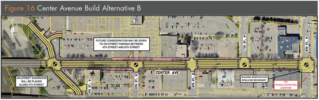
11 Center Avenue (Red River to 8th Street) Alternative Cost** Public Comments SRC Ranking Does the Alternative Move Forward? No Build Build Alternative A:*** Reduces queues, except at 4th Street; queues will increase eastbound. Enhances bicycle network through onstreet bike lanes on the Center Avenue/NP Avenue Bridge. $0 (construction) None Received 3 $3.2M (construction) Mostly Positive Recommended Yes Yes Build Alternative B:*** Reduces queues. $3.2M (construction) Mostly Positive 2 Yes ** Cost estimates do not include right of way or relocation costs, only estimates of construction costs. *** Each Build Alternative has the following impacts: Improves pavements (full reconstruction) and utilities. Improves safety. Closes 1 access point Removes 40 off-street parking spaces. Includes 5,500 s.f. of ROW acquisition. Upgrades sidewalks and streetscaping. 11
12 Center Avenue Implementation Can be funded: 100% Local Funds 100% MSA Funds Combination of Local & MSA Funds Mix of Federal STP Funds, MSA Funds, & Local Funds (Environmental Document would be required) Project should be completed no later than 10 years (2023) 12
13 TH 10 RED RIVER TO TH

14 TH 10 Corridor Issues Pavement Conditions MnDOT RQI poor from Red River to CR 9; fair to TH 336 At-grade rail crossing of TH 10 between Center and Main Avenue has a high vehicle/rail exposure Limited Existing ROW Private property may need to be purchased High Number of Access Points Corridor ranges from 1.5 to 4 times higher than standard 14
15 TH 10 Corridor Issues High Vehicle Crash Locations 8 th St/Main Ave and 8 th St/Center Ave intersections 7 of 15 intersections exceed crash severity rate Congestion and Intersection Geometries At-grade RR crossings and signal preemption Significant delay at 8 th St/Main Ave intersection (existing Level of Service D) Bicycle and Pedestrian Safety and Mobility System gaps 15
 All Build alternatives and subalternatives include pavement rehabilitation")
16 TH 10 Alternative Development & Evaluation TH 10 developed and evaluated as five segments (Moorhead includes segments 1, 2 and 3) All Build alternatives and subalternatives include pavement rehabilitation costs 16
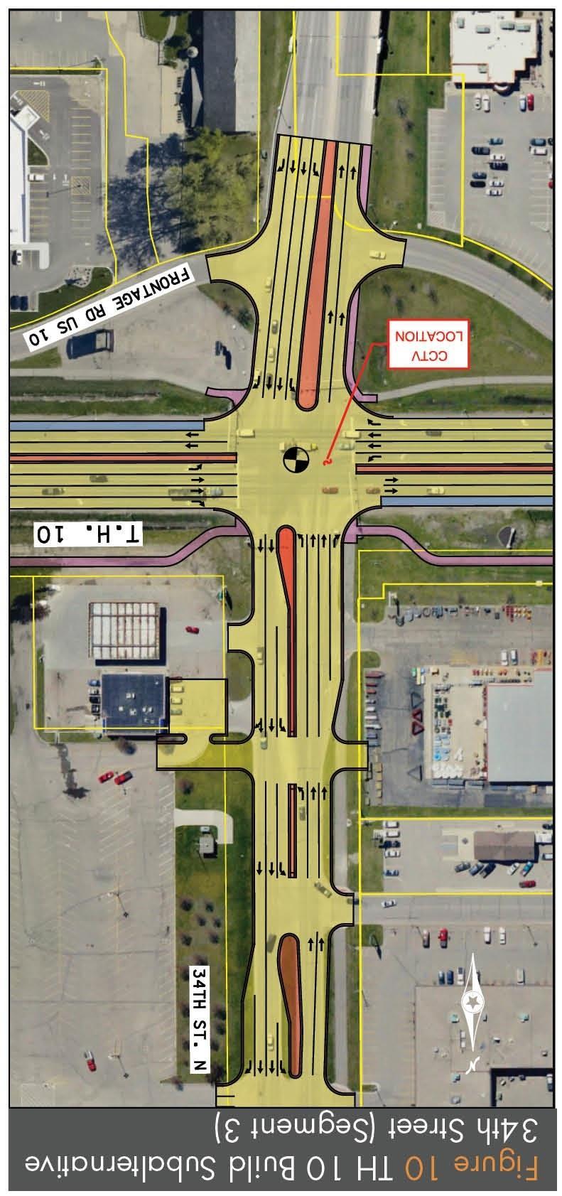
17 17
18 18
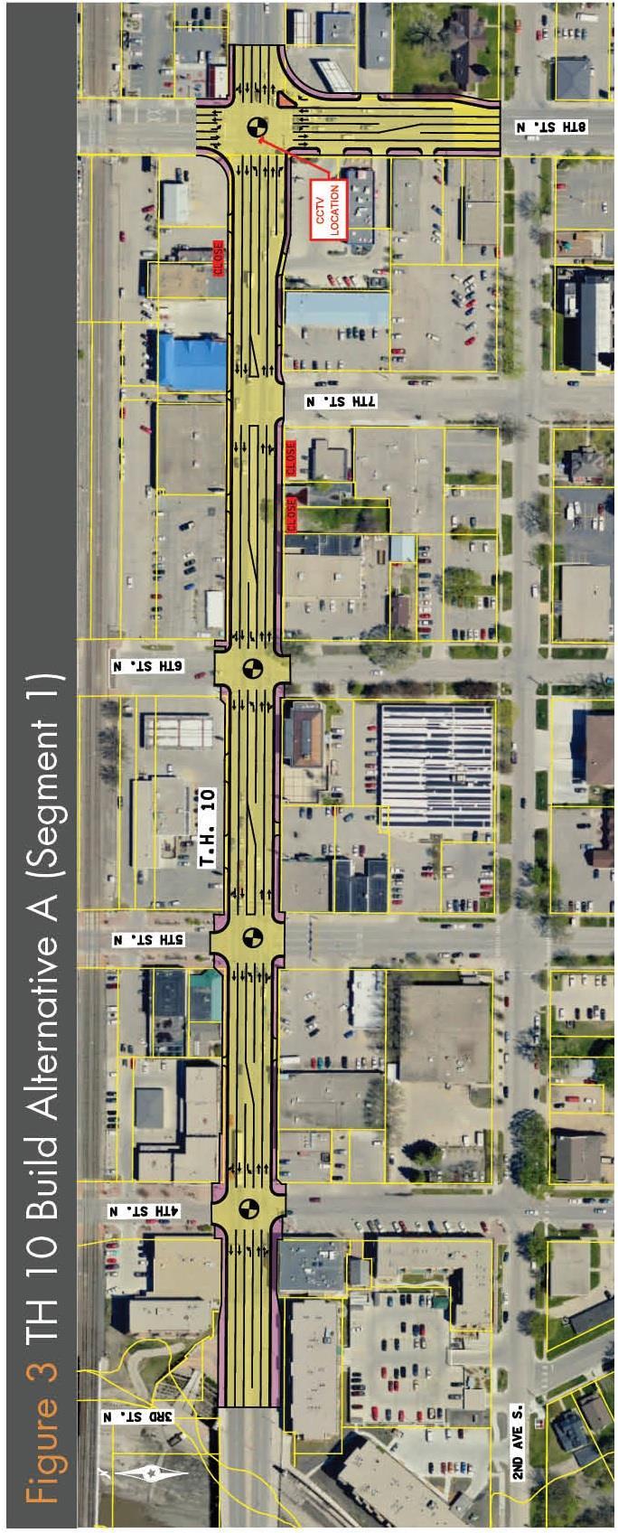
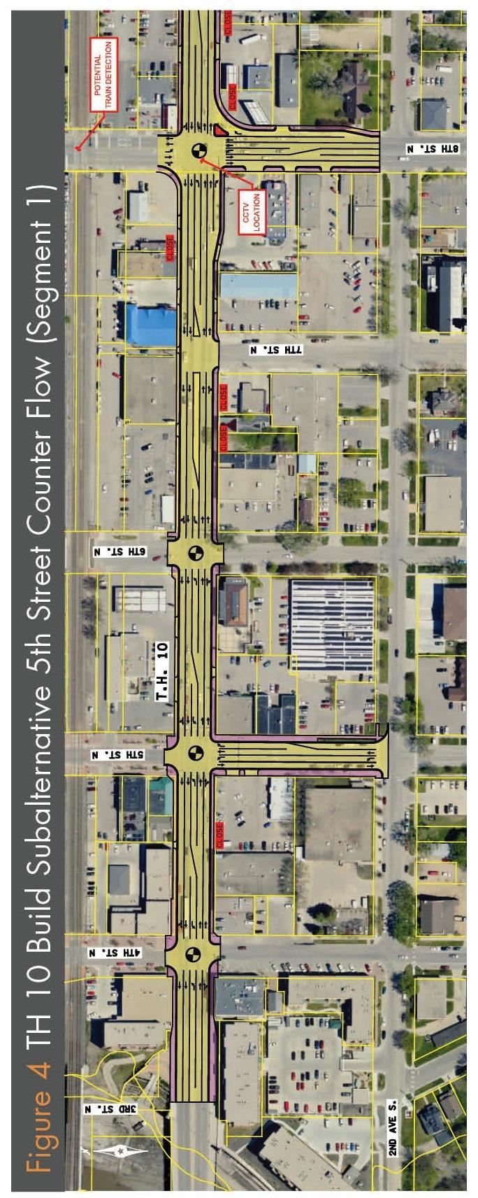
19 TH 10 Segment 1 (Red River to 8th Street) Alternative Cost** Public Comments No Build $0 (construction) None Received SRC Ranking Not Recommended Does the Alternative Move Forward? Yes Build Alternative A:*** Closes three access points. $2.2M (construction) Mixed Recommended Yes Subalternative 5th Street Counter Flow:*** Closes one more access point than Build Alternative A. Reduces circuitous travel with 5th Street one-way to two-way conversion. Increases vehicle conflicts at TH 10/ 5th Street intersection with the two-way conversion. $0.1M (construction) Mixed/ Mostly Negative Not Recommended No ** Cost estimates do not include right of way or relocation costs. *** Each Build Alternative and Subalternative has the following impacts: Improves pavements. Improves safety. Reduces delay at 8th Street. Includes 4,000 s.f. of ROW acquisition. Reduces queues on TH 10. Upgrades sidewalks and streetscaping. Removes 20 on-street parking spaces. Provides opportunity for property redevelopment. 19
20 20
21 21
22 22
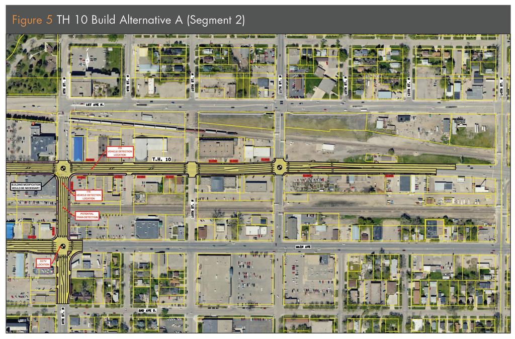
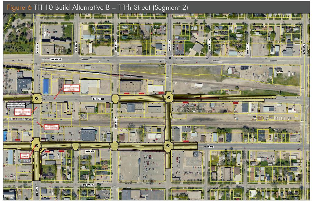
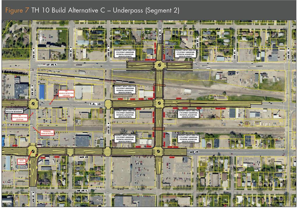
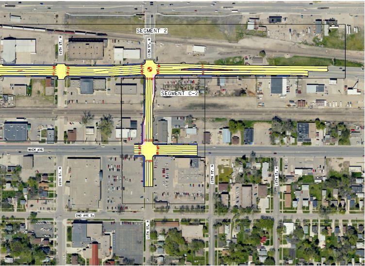
23 Alternative No Build TH 10 Segment 2 (8th Street to 14th Street) Cost** $0 (rehabilitation) Public Does the Alternative SRC Ranking Move Forward? Comments None Received 4 Yes Build Alternative A:*** Closes 12 access points. Includes 8,500 s.f. of ROW acquisition. Removes six on-street parking spaces. Build Alternative B 11th Street:*** Reduces queues on TH 10. Closes eight access points. Includes 14,000 s.f. of ROW acquisition. Build Alternative C Underpass:*** Reduces queues on TH 10. Closes 31 access points. Includes 306,000 s.f. of ROW acquisition (includes buildings). ** Cost estimates do not include right of way or relocation costs. $1.7M (rehabilitation) $2.6M (rehabilitation) $37.1M (rehabilitation) Mostly Positive Mostly Positive 3 Recommended This alternative will be reevaluated as part Mostly 2 Positive of a future vehicle/rail operation study. *** Each Build Alternative has the following impacts: Improves pavements. Improves safety. Upgrades sidewalks and streetscaping. Provides opportunity for property redevelopment. 23 Enhances ITS on the corridor. Yes Yes
24 24
25 25
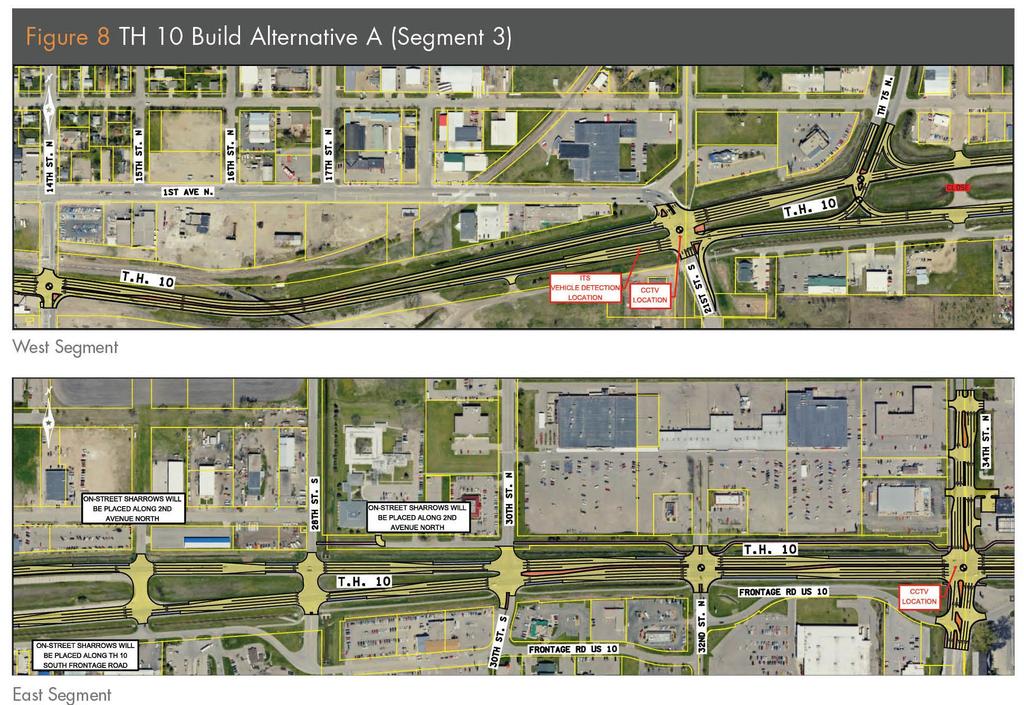
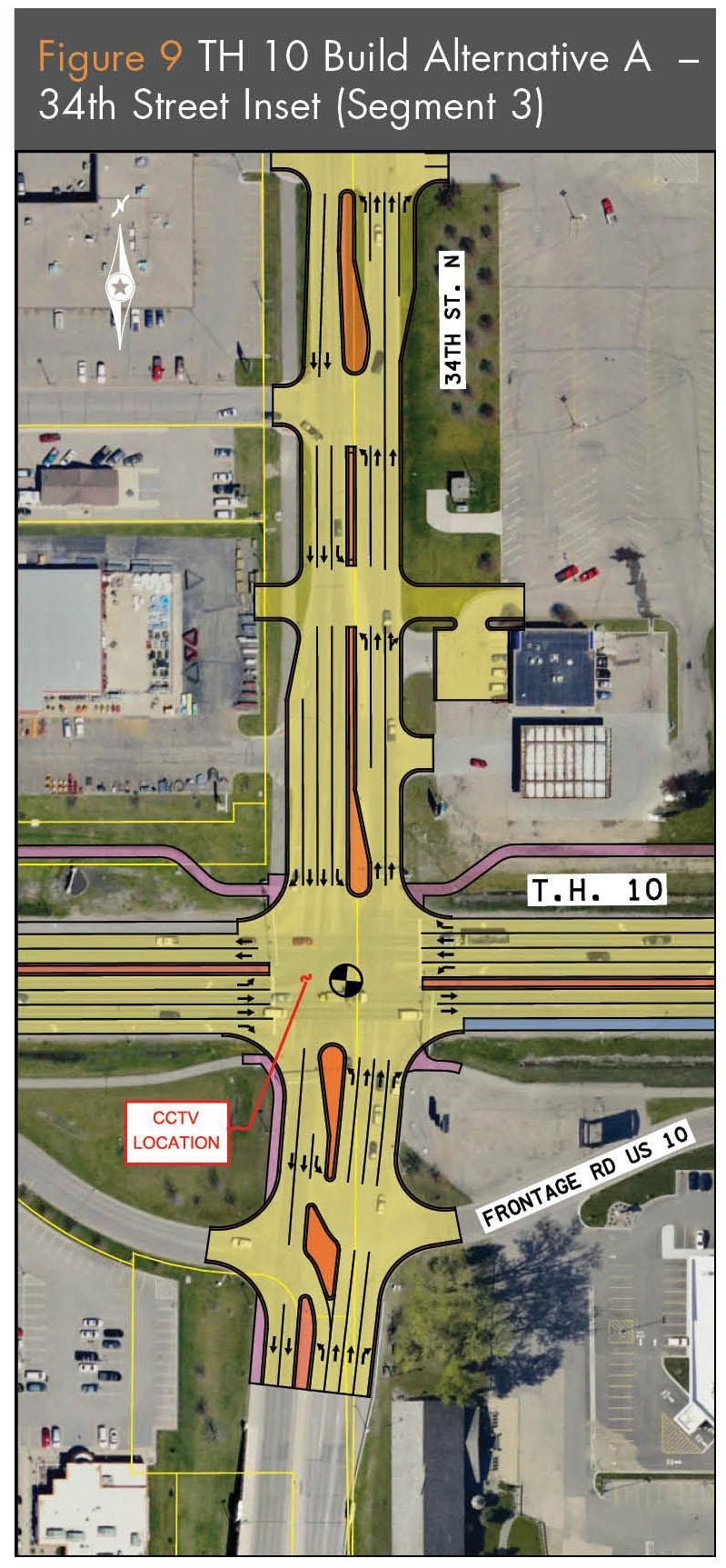
26 Alternative TH 10 Segment 3 (14th Street to 34th Street) Cost** Public SRC Ranking Comments Does the Alternative Move Forward? No Build Build Alternative A:*** Closes one access point and modifies one access point to 3/4 access. None Not $0 (construction) Yes Received Recommended $5.6M (construction) Mixed Recommended Yes Subalternative 34th Street:*** Closes one access point and modifies one access point to right- in, right-out access. $0 (construction) Mostly Negative Not Recommended No ** Cost estimates do not include right of way or relocation costs. *** Each Build Alternative and Subalternative has the following impacts: Improves pavements. Enhances ITS on the corridor. Reduces queues at 21st Street and 34th Street. Extends northbound right-turn lane at 21st Street. Enhances streetscape. Includes 500 s.f. of ROW acquisition. Upgrades/add new sidewalks, on-street sharrows, and multiuse trails. Provides opportunity for property redevelopment. 26

27 Downtown Roadway / Rail System Analysis Conducted an analysis of varying roadway modifications to improve adjacent roadway network in relation to at-grade rail crossings at 8th,11th and 14th Streets 27
28 Downtown Roadway / Rail System Analysis The alternatives evaluated included: Base Condition ~ CTC preemption and signal timing improvements and flashing yellow arrow (implementation by City of Moorhead) Alternative 1: Base + 11th and 14th Street converted to one-ways Alternative 2: Base + 14th Street one-way NB Alternative 3: Base + convert 8th Street NB curb lane to a right-turn lane Alternative 4: Base + jurisdictional transfer to 11th Street and geometric improvements (closely related to Segment 2 Build Alt. B) Alternative 5: Alternative 4 + grade separation of RR tracks along 11th Street 28

29 Downtown Roadway / Rail System Analysis 29
30 TH 10 Implementation Plan 1. Implement the Campbell Technologies Corporation recommended railroad preemption operation improvements (2013) 2. Pilot year of collaborative, corridor-based competitive solicitation process for MnDOT TH projects called the Corridor Investment Management Strategy (CIMS). Moorhead and MnDOT are working together to develop a grant application that would cover Segments 1 and 2 of TH 10. Solicitation deadline for grants is April 30, Projects selected must be let by June 5, 2015 or earlier. 3. CIMS application includes the following for Segments 1 and 2 of TH 10 ADA improvements Pavement Rehabilitation Intersection geometric improvements ITS 4. TH 10 CIMS project cost is estimated to be $2.2 million. Local system costs = $257,750; TH 10 system costs = $1,937,750 of which 90% will by CIMS grant and 10% will be local cost. Total City cost = $450,

31 CIMS Geometric Improvements 31
32 TH 10 Implementation Plan (continued) 4. MnDOT s long term desire to reduce the atgrade crossing of TH 10 and TH 75 by either grade separating the crossing, re-routing the alignment of the TH s, or a combination of both. Moorhead s long term desire to construct a grade separation in downtown Moorhead. This will result in a future study to determine the best option to reduce vehicle/rail exposures on the TH systems and to improve vehicle/train operations in downtown Moorhead. 32
33 TH TH AVENUE SOUTH TO MAIN AVENUE 33

34 TH 75 Corridor Issues Pavement Conditions MnDOT RQI is poor High Number of Access Points 58 access points per mile; exceeds standard in Moorhead City Code by 3 times Traffic Operations Queues at 12 th Ave S exceed 250 ft. 34
35 TH 75 Corridor Issues High Vehicle Crash Locations Critical crash rates high at intersections of 20 th Ave S, 12 th Ave S, and 4 th Ave S Bicycle and Pedestrian Safety and Mobility ADA compliance along sidewalks Bicycle and pedestrian gaps 35
36 36
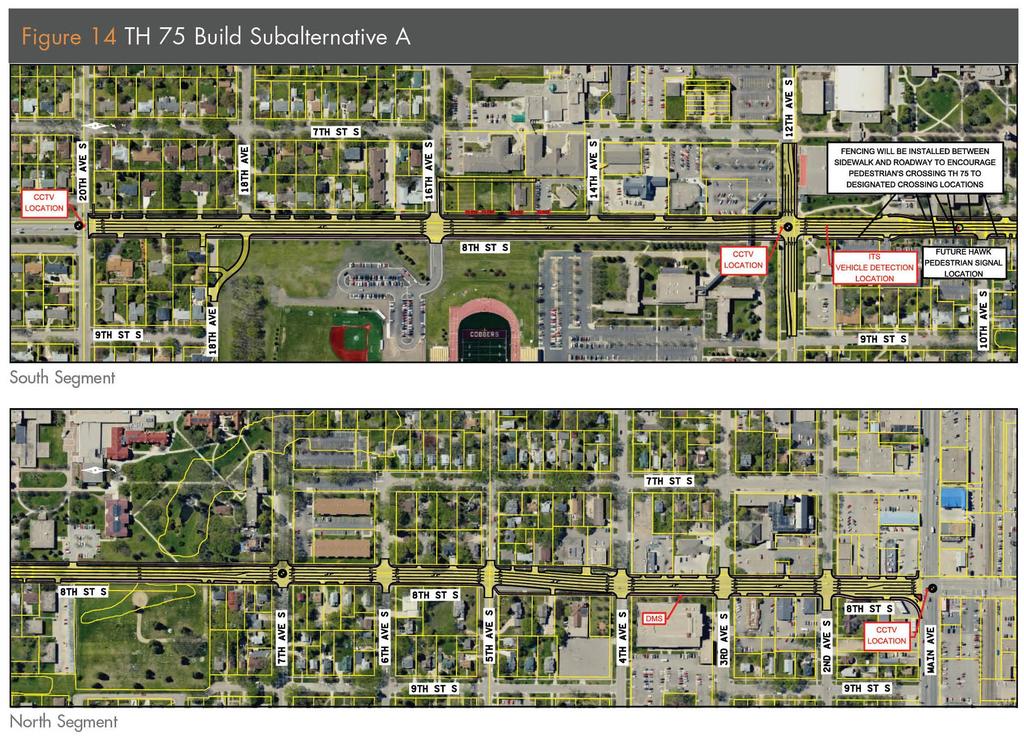
37 TH 75 (20th Avenue S to TH 10) Alternative Cost** Public Comments SRC Ranking Does the Alternative Move Forward? No Build $0 (construction) None Received Not Recommended Yes Build Alternative A Improves pavements and utilities. Reduces queues at 12th Avenue South. Improves safety. Closes four access points. Includes 14,700 s.f. of ROW acquisition. Upgrades sidewalks and streetscapes. $3.5M (rehabilitation) Mostly Positive Recommended Yes ** Cost estimates do not include right of way or relocation costs. 37
38 Potential TH 75 Reroute Options Six reroute options were evaluated to determine the quantitative and qualitative benefits or impacts of transferring TH 75 Conducted a preliminary screening evaluation based on the following criteria: Jurisdictional mileage changes Origin-Destination patterns of traffic in the area between select locations Travel times between defined termini Potential traffic diversion that may occur Land use compatibility between routes Corridor access comparison Corridor safety comparison Potential operational benefits or concerns Planning level cost estimates 38
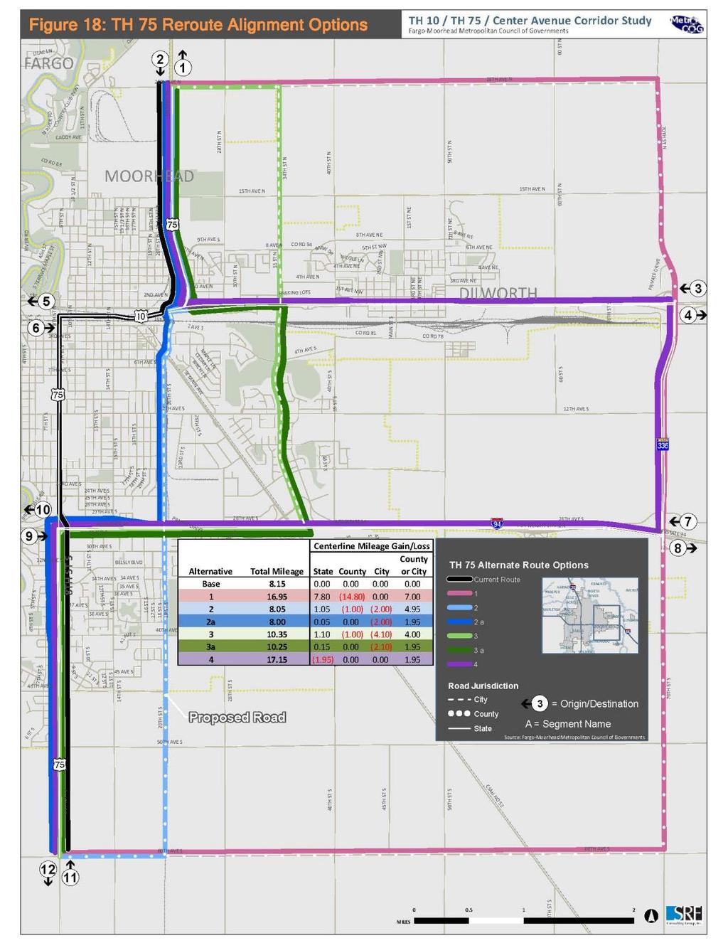
39 39
40 TH 75 Implementation Plan 1. MnDOT determined that re-routing the alignment of TH 75 outside of downtown Moorhead is not beneficial to them if TH 10 stays as a corridor through the downtown with an at-grade rail crossing. 2. TH 75 would be eligible for future NHPP funding. 3. The TH 75 crossing of the railroad will also result in a future study to determine the best option to reduce vehicle/rail exposures on the TH systems and to improve vehicle/train operations in downtown Moorhead. 40
41 Next Steps Finalize ROW Costs with MnDOT Staff Get Feedback from the Public on Recommendations Finalize Report Move toward Environmental Documentation Phase Continue development of CIMS application 41
42 Project Implementation Timeline 2013 MnDOT TH 10/TH 75 Project (Pavement/ADA) Moorhead Signal/Preemption Improvement Project 2014/ 2015 Additional Grade Separation Study for TH 10/75 in Downtown Moorhead Possible TH 10/TH 75 Project (resulting from CIMS) TH 75 (20 th Ave S to Main Ave) not part of CIMS Center Avenue Reconstruction 42
 249-6713 or bshorten@srfconsulting.com Craig Vaughn (763) 249-6774 or cvaughn@srfconsulting.")
43 Who do I contact for more information? Peggy Harter, P.E. Senior Transportation Planner Metro COG (701) Ext. 33 harter@fmmetrocog.org SRF Consulting Staff: Brian Shorten (763) or bshorten@srfconsulting.com Craig Vaughn (763) or cvaughn@srfconsulting.com Rick Lane (701) or rlane@srfconsulting.com 43
Municipal Class EA To Address Traffic Congestion On The Ontario Street Corridor (Grand Bend) Public Information Meeting June 4, 2018
 Public Information Meeting June 4, 2018") Municipal Class EA To Address Traffic Congestion On The Ontario Street Corridor (Grand Bend) Public Information Meeting June 4, 2018 Background Agenda Traffic Study Update Class EA Alternatives Bridge
Municipal Class EA To Address Traffic Congestion On The Ontario Street Corridor (Grand Bend) Public Information Meeting June 4, 2018 Background Agenda Traffic Study Update Class EA Alternatives Bridge
1. What is the Doran Street and Broadway/Brazil Grade Separation Project (Project)?
?") 1. What is the Doran Street and Broadway/Brazil Grade Separation Project (Project)? The Los Angeles County Metropolitan Transportation Authority (Metro) is evaluating the development of a grade separation
1. What is the Doran Street and Broadway/Brazil Grade Separation Project (Project)? The Los Angeles County Metropolitan Transportation Authority (Metro) is evaluating the development of a grade separation
City of Gainesville Transportation/Roadway Needs PROJECT SUMMARY
 A1 Roadway Resurfacing $23,846,000 TYPE: Preservation of existing system Roadway resurfacing A2 Signal Replacement $6,000,000 TYPE: Preservation of existing system Replace traffic signals. B1 W 6th St
Conversion of One-Way Couplet Streets to Two-Way
 Conversion of One-Way Couplet Streets to Two-Way May 5, 2016 Oklahoma Traffic Engineers Association 2016 Spring Meeting, Tulsa, OK Kevin St. Jacques, P.E., PTOE, PTP Freese and Nichols Overview Initial
Washington St. Corridor Study
 FIGURE 7.17 Bridge Alternatives - Cross Sections 86 Discarded Alternative: Short-Term Bridge Repair Short-term repairs and west bridge span replacement were considered during analysis. Short-term repairs
Bicycle and Pedestrian Chapter TPP Update Overview. TAB September 20, 2017
 Bicycle and Pedestrian Chapter TPP Update Overview TAB September 20, 2017 Bicycling & Walking in the Twin Cities Where are we now? The Bike-Pedestrian system Current trends New developments Where are we
Chapter 5 Future Transportation
 Chapter 5 Future Transportation The Future Land Use Plan identifies the desired land use designations. The land uses desired for Crozet depend, in large part, on the success of the transportation system,
Philip Schaffner Minnesota Department of Transportation October 22, 2013
 Philip Schaffner Minnesota Department of Transportation October 22, 2013 Going beyond performance measures & targets MnDOT has been using performance-based planning and programming for 10 years, but CIMS
42nd Ave N Reconstruction
 CITY OF MINNEAPOLIS 42nd Ave N Reconstruction Community Meeting #2 May 2016 6:00 7:30 p.m. 5/16/2016 1 Purpose of Meeting Inform: Provide an overview of project, identify anticipated scope of work, and
Hennepin/First Transportation Study
 CITY OF MINNEAPOLIS Hennepin/First Transportation Study NIEBNA Board Meeting November 10, 2016 11/10/2016 1 Study Overview Evaluate transportation system and alternatives Coordinate with County, Metro
Proposed. City of Grand Junction Complete Streets Policy. Exhibit 10
 Proposed City of Grand Junction Complete Streets Policy Exhibit 10 1 City of Grand Junction Complete Streets Policy Vision: The Complete Streets Vision is to develop a safe, efficient, and reliable travel
WALKNBIKE DRAFT PLAN NASHVILLE, TENNESSEE EXECUTIVE SUMMARY NASHVILLE, TENNESSEE
 NASHVILLE, TENNESSEE EXECUTIVE SUMMARY Executive Summary A world-class multi-modal transportation system is essential to a vibrant city and better quality of life. -Mayor Barry The WalknBike plan aims
Brooklyn Boulevard (County Road 152) Reconstruction Project Phase I. OPEN HOUSE June 20, 2017
 Reconstruction Project Phase I. OPEN HOUSE June 20, 2017") Brooklyn Boulevard (County Road 152) Reconstruction Project Phase I OPEN HOUSE June 20, 2017 Brooklyn Boulevard (County Road 152) Phase I Project Partners Project Lead Other Project Partners include Brooklyn
Brooklyn Boulevard (County Road 152) Reconstruction Project Phase I OPEN HOUSE June 20, 2017 Brooklyn Boulevard (County Road 152) Phase I Project Partners Project Lead Other Project Partners include Brooklyn
Overview. Illinois Bike Summit IDOT Complete Streets Policy Presentation. What is a Complete Street? And why build them? And why build them?
 Overview Illinois Bike Summit IDOT Complete Streets Policy Presentation Aren Kriks, P.E. District One Bicycle Coordinator and Bureau of Programming Project Engineer History of Complete Streets IDOT Policy
Recommendations. Central Salem Mobility Study
 Central Salem Mobility Study The Central Salem Mobility Study evaluated a range of multimodal transportation issues affecting downtown Salem, including circulation, access, and safety for people traveling
Railroad-Highway Grade Crossing Analysis for Corridor Planning Projects
 Railroad-Highway Grade Crossing Analysis for Corridor Planning Projects Word Count: 4,305 Submission Date: August 1, 2015 Author: Adriana Rodriguez, E.I Assistant Engineer Parsons Brinckerhoff 1420 South
WELCOME. Stakeholder Involvement Group Meeting #2 Round Lake Public Works October 24, 2018
 WELCOME Stakeholder Involvement Group Meeting #2 Round Lake Public Works October 24, 2018 MEETING AGENDA 1. Welcome and Introductions 2. Study Progress Update 3. Problem Statement 4. Technical Analysis
Omaha s Complete Streets Policy
 Omaha s Complete Streets Policy (Adopted August 2015) VISION To create great places and enhance our quality of life, the City of Omaha will provide safe, accessible streets for all users. Complete Streets
Bus Rapid Transit Plans
 Twin Cities Region Bus Rapid Transit Plans ULI Minnesota Workshop Connecting Bus Rapid Transit to the Community December 15, 2009 John Levin Director of Service Development Metro Transit Metropolitan Area
City of Wilsonville 5 th Street to Kinsman Road Extension Project
 City of Wilsonville 5 th Street to Kinsman Road Walking Tour & Neighborhood Workshop Summary Report Public Outreach Overview On July 18 th, 2017, the City of Wilsonville hosted a neighborhood walking tour
Southwest Bus Rapid Transit (SW BRT) Functional Planning Study - Executive Summary January 19 LPT ATTACHMENT 2.
 Functional Planning Study - Executive Summary January 19 LPT ATTACHMENT 2.") Southwest Bus Rapid Transit (SW BRT) Functional Planning Study - Executive Summary 2011 January 19 1 of 19 Introduction This executive summary presents the results of the Southwest Bus Rapid Transit (SW
Southwest Bus Rapid Transit (SW BRT) Functional Planning Study - Executive Summary 2011 January 19 1 of 19 Introduction This executive summary presents the results of the Southwest Bus Rapid Transit (SW
Watertown Complete Streets Prioritization Plan. Public Meeting #1 December 14, 2017
 Watertown Complete Streets Prioritization Plan Public Meeting #1 December 14, 2017 Goals for Public Meeting Overview of MassDOT Complete Streets Funding Program Educate the community on Complete Streets
Capital Metro Downtown Multimodal Station
 Capital Metro Downtown Multimodal Station Open House December 11, 2015 Project Goals & Objectives 1 2 3 4 Address near- and long- term MetroRail operational needs Address existing safety issues and modal
In Collaboration with: City of Belton Cass County FHWA Johnson County KDOT MoDOT City of Olathe City of Overland Park
 In Collaboration with: City of Belton Cass County FHWA Johnson County KDOT MoDOT City of Olathe City of Overland Park I. Background During the Johnson County Board of County Commissioner s (JCBOCC) meeting
Tonight is for you. Learn everything you can. Share all your ideas.
 Strathcona Neighbourhood Renewal Draft Concept Design Tonight is for you. Learn everything you can. Share all your ideas. What is Neighbourhood Renewal? Creating a design with you for your neighbourhood.
Glenn Avenue Corridor Traffic Operational Evaluation
 Glenn Avenue Corridor Traffic Operational Evaluation PREPARED FOR: THE CITY OF AUBURN PREPARED BY: DECEMBER 2007 Glenn Avenue Corridor Study--Auburn, Alabama TABLE OF CONTENTS Introduction... 1 Background
5. RUNNINGWAY GUIDELINES
 5. RUNNINGWAY GUIDELINES These guidelines should be considered collectively when making runningway decisions. A runningway is the linear component of the transit system that forms the right-of-way reserved
Virginia Street Bus RAPID Transit Extension Project. Environmental Assessment (EA) Presentation Public Hearing June 22, 2017
 Presentation Public Hearing June 22, 2017") Virginia Street Bus RAPID Transit Extension Project Environmental Assessment (EA) Presentation Public Hearing June 22, 2017 Presentation to RTC July 17, 2015 Presentation Overview Project Timeline Environmental
Virginia Street Bus RAPID Transit Extension Project Environmental Assessment (EA) Presentation Public Hearing June 22, 2017 Presentation to RTC July 17, 2015 Presentation Overview Project Timeline Environmental
VT15 / Allen Martin Drive Intersection Scoping Study
 VT15 / Allen Martin Drive Intersection Scoping Study ALTERNATIVES PRESENTATION MEETING DECEMBER 19, 2016 Agenda Study Area Project Background Existing Conditions Identified Issues Proposed Alternatives
CONNECTIVITY PLAN. Adopted December 5, 2017 City of Virginia Beach
 CONNECTIVITY PLAN Adopted December 5, 2017 City of Virginia Beach CONTENTS 1.0 Background & Purpose... 2 2.0 Existing Inventory & Analysis... 3 ViBe District Existing Walking Conditions... 4 3.0 ViBe District
Traffic Calming Policy
 Article I. Purpose and Goal. The purpose of this policy is to establish criteria and procedures the City will use to evaluate requests for, and if appropriate, implement traffic calming measures. Neighborhood
Frequently Asked Questions
 Frequently Asked Questions Business US 190 in Copperas Cove From Avenue D to Constitution Drive What is access management? A. Access Management is a growing effort by government agencies to improve how
Welcome to the Quebec Alternatives Analysis Public Meeting
 Welcome to the Public Meeting Please sign in. Public Comment Please fill out a comment card and tell us what you think. Check back or comment any time at: www.quebecalternatives.com Project Area Technical
Reference number /VP. Lafayette Downtown Congestion Study - Additional Traffic Analysis
 To James Hinkamp and Tony Coe, City of Lafayette Date January 19, 2017 Copies Reference number 243381/VP From Michael Iswalt and Vanessa Peers File reference 4-05 Subject Lafayette Downtown Congestion
Newport City Thoroughfare Plan
 Newport City Thoroughfare Plan Summary This plan is intended to review and make recommendations for Newport City s thoroughfare network, in consideration of the full range of uses of the city s streets.
Reams Road RCA Study. Board of County Commissioners Public Hearing
 Reams Road RCA Study Board of County Commissioners Public Hearing April 24, 2018 Presentation Overview Study Overview Existing Conditions Development of Alternatives Preferred Alternative Public Involvement
Glebe Neighbourhood Cycling Plan
 Glebe Neighbourhood Cycling Plan Summary of Public Comments received after June 5 th Public Information Session Comment STUDY NETWORK CS9, CS8, E, E0 CS4, E CS4 CS8 E Suggestions for alternate cycling
North Avenue Corridor Study
 North Avenue Corridor Study Advisory Committee Meeting #6 July 1, 2014 Agenda Concept Revisions based on Advisory Committee feedback Review of New Concept Scoring & Costs Concept Discussion/Questions Voting:
Albany Shaker Road Corridor Study Public Meeting # 2
 Albany Shaker Road Corridor Study Public Meeting # 2 Scope / Meeting Purpose This project is a CDTC Linkage Study. The Linkage Program is designed to implement the adopted planning and investment principles
St. Francis Drive through the City of Santa Fe Corridor Study
 VII. ENGINEERING AND ENVIRONMENTAL EVALUATION TRAIL CONNECTIVITY In the southern portion of the Corridor there is a lack of a sidewalk, trail or bicycle facility within the right-ofway. However, the City
MPO Staff Report Technical Advisory Committee: May 10, 2017 MPO Executive Board: May 17, 2017
 MPO Staff Report Technical Advisory Committee: May 10, 2017 MPO Executive Board: May 17, 2017 RECOMMENDED ACTION: Update on the NDDOT US Business 2 Project Programmed for 2019 Matter of the NDDOT US Business
ACTIVE TRANSPORTATION
 ACTIVE TRANSPORTATION Mobility 2040 Supported Goals Improve the availability of transportation options for people and goods. Support travel efficiency measures and system enhancements targeted at congestion
Chapter 6: Transportation
 Chapter 6: Transportation I. INTRODUCTION The purpose of the Transportation Plan element of the Comprehensive Plan is to provide guidance to the City of North Mankato, as well as existing and future landowners
Hennepin County Transportation Department
 Hennepin County Transportation Department Complete Streets Design and Implementation Prepared for the Complete Streets Task Force Craig Twinem, P.E. Design Division Manager Tom Johnson, P.E. Transportation
TRANSPORTATION & MOBILITY
 TRANSPORTATION & MOBILITY ROADWAY SYSTEM There are approximately 40 miles of roadways in Manitou Springs. For planning purposes, roadways are typically assigned a functional classification which defines
PROJECT OBJECTIVES. Improve vehicle capacity for the intersection. Improve pedestrian and bicycle access
 COMMUNITY MEETING Project Update March 15, 2010 Purcellville, Virginia OVERVIEW Project need / objectives Project recap Design elements Proposed improvements Summary of project benefits / next steps PROJECT
Project Overview. Rolling Road Widening Fairfax County. Get Involved. Design Public Hearing. Contact Information
 Get Involved VDOT representatives will review and evaluate information received as a result of this meeting. Please fill out the comment sheet provided in this brochure if you have any comments or questions.
PROPOSED BICYCLE AND PEDESTRIAN FACILITY Vicinity of Route 123/I-495 Interchange Tysons, Fairfax County, Virginia
 PROPOSED BICYCLE AND PEDESTRIAN FACILITY Vicinity of Route 123/I-495 Interchange Tysons, Fairfax County, Virginia PRELIMINARY ENGINEERING REPORT Prepared for: Prepared by: July 2017 Table of Contents 1
Los Altos Hills Town Council - June 18, 2015 Palo Alto City Council June 22, AGENDA ITEM #2.B Presentation
 Los Altos Hills Town Council - June 18, 2015 Palo Alto City Council June 22, 2015 AGENDA ITEM #2.B Presentation Previous Presentations Los Altos Hills Town Council in May 2014 and February 2015 Palo Alto
APPENDIX A: Complete Streets Checklist DRAFT NOVEMBER 2016
 APPENDIX A: Complete Streets Checklist DRAFT NOVEMBER 2016 Complete Streets Checklist MetroPlan Orlando s Complete Streets Checklist is an internal planning tool for staff to further implementation of
WYDOT DESIGN GUIDES. Guide for. NHS Arterial (Non-Interstate)
") WYDOT DESIGN GUIDES Guide for NHS Arterial (Non-Interstate) 2014 GUIDE FOR NATIONAL HIGHWAY SYSTEM (NHS) HIGHWAYS (NHS ARTERIALS, Non-Interstate) PRESERVATION REHABILITATION RECONSTRUCTION INTRODUCTION
WYDOT DESIGN GUIDES Guide for NHS Arterial (Non-Interstate) 2014 GUIDE FOR NATIONAL HIGHWAY SYSTEM (NHS) HIGHWAYS (NHS ARTERIALS, Non-Interstate) PRESERVATION REHABILITATION RECONSTRUCTION INTRODUCTION
Abstract. Background. protected/permissive operation. Source: Google Streetview, Fairview/Orchard intersection
 ITE 2015 Western District Annual Meeting Ada County Highway District s Flashing Yellow Arrow Initiative Primary Author: Tim Curns, PE Ada County Highway District Traffic Engineer Author: Andrew Cibor,
RiNo Railroad Crossing Connectivity Analysis. Stakeholder Workshop June 29, 2017
 RiNo Railroad Crossing Connectivity Analysis Stakeholder Workshop June 29, 2017 Ideas and Considerations Presented at Stakeholder Workshop Primary Focus: 38 th Street (between Walnut & Wynkoop) 1 Basic
Princeton Avenue and Spruce Street Transportation and Site Access Enhancements Project
 Princeton Avenue and Spruce Street Transportation and Site Access Enhancements Project Mercer County Planning Division AECOM Transportation (formerly DMJM Harris) January 29, 2009 Agenda Project Status
Caltrans Sloat Boulevard Pedestrian Safety Project Response to Community Questions, Comments & Concerns
 Caltrans Sloat Boulevard Pedestrian Safety Project Response to Community Questions, Comments & Concerns Revised: May 10, 2016 The California Department of Transportation (Caltrans) is planning various
I-20 ODESSA-MIDLAND CORRIDOR STUDY. Public Meeting for Schematic Design
 I-20 ODESSA-MIDLAND CORRIDOR STUDY Public Meeting for Schematic Design The environmental review, consultation, and other actions required by applicable Federal environmental laws for this project are being,
Living Streets Policy
 Living Streets Policy Introduction Living streets balance the needs of motorists, bicyclists, pedestrians and transit riders in ways that promote safety and convenience, enhance community identity, create
Pine Hills Road Pedestrian/Bicycle Safety Study Board of County Commissioners Work Session
 Pine Hills Road Pedestrian/Bicycle Safety Study Board of County Commissioners Work Session February 20, 2018 Meeting Agenda Study Overview Existing Conditions Access Management Potential Gateway Features
Designing with the Railroad
 Designing with the Railroad 23 CFR 646.214 (b)(2) requires that crossings be evaluated when they are within limits or near terminus of Federally Funded project. Some rough numbers for planning: Active
HYATTSVILLE TRANSPORTATION PLAN. City Council Update March 19, 2018
 HYATTSVILLE TRANSPORTATION PLAN City Council Update March 19, 2018 AGENDA PROJECT GOALS DATA COLLECTION WHAT WE LEARNED NEXT STEPS PROJECT GOALS Identify bicycle and pedestrian needs of the city Evaluate
Shockoe Bottom Preliminary Traffic and Parking Analysis
 Shockoe Bottom Preliminary Traffic and Parking Analysis Richmond, Virginia August 14, 2013 Prepared For City of Richmond Department of Public Works Prepared By 1001 Boulders Pkwy Suite 300, Richmond, VA
Simulating Street-Running LRT Terminus Station Options in Dense Urban Environments Shaumik Pal, Rajat Parashar and Michael Meyer
 Simulating Street-Running LRT Terminus Station Options in Dense Urban Environments Shaumik Pal, Rajat Parashar and Michael Meyer Abstract The Exposition Corridor transit project is a light rail project
ADVANCED TRANSIT OPERATIONS AND MODELING
 SOUTHERN DISTRICT OF INSTITUTE OF TRANSPORTATION ENGINEERS (SDITE) 2017 ADVANCED TRANSIT OPERATIONS AND MODELING SURESH KARRE, PE, PTOE ROBERT DUBNICKA, PE, TE, PTOE AGENDA Background Transit operations
Basalt Creek Transportation Refinement Plan Recommendations
 Basalt Creek Transportation Refinement Plan Recommendations Introduction The Basalt Creek transportation planning effort analyzed future transportation conditions and evaluated alternative strategies for
TRANSPORTATION & MOBILITY VISIONING MEETING. August 23 24, 2017
 TRANSPORTATION & MOBILITY VISIONING MEETING August 23 24, 2017 Project Team 1999 South Lakefront Framework Plan In 1999, the Chicago Park District authorized framework plans for three historic parks: Jackson,
ADA Transition Plan. City of Gainesville FY19-FY28. Date: November 5, Prepared by: City Of Gainesville Department of Mobility
 ADA Transition Plan FY19-FY28 Date: November 5, 2018 Prepared by: City Of Gainesville Department of Mobility 1.0 INTRODUCTION 1.1 BACKGROUND The federal statute known as the Americans with Disabilities
Welcome. Thank you for your interest in the Lewis & Clark Viaduct Concept Study
 Welcome Thank you for your interest in the Lewis & Clark Viaduct Concept Study Please use the arrows in the upper left hand corner to navigate through the presentation. Use the envelope icon to ask a question
Project Update May 2018
 Project Update May 2018 Dakota County, in cooperation with the City of Lakeville, is planning to reconstruct 202 nd Street West (County Road 50) from Holyoke Avenue to Cedar Avenue (County Road 23). 202
Governance and Priorities Committee Report For the July 2, 2015 Meeting
 CITY OF VICTORIA For the July 2, 2015 Meeting To: Governance and Priorities Committee Date: From: Subject: Brad Dellebuur, A/Assistant Director, Transportation and Parking Services Executive Summary The
Blair/Williamson Intersection Expressed Needs
 Blair/Williamson Intersection Expressed Needs NORTH Blair Street is a barrier for pedestrians and bicycles Relocate Capitol City Trail crossing from Blair Street and John Nolen Drive intersection to Williamson
Draft North Industrial Area-Wide Traffic Plan
 Summary of North Industrial and Hudson Bay Industrial Recommended Improvements Table 1. Summary of s Item Location 1 2 3 4 5 6 7 8 9 10 11 12 Millar Ave north of 51st St Super 8 Motel back lane 400 Block
MEMORANDUM. Earl Haugen and UND Transportation and Traffic Coordination Committee
 SRF No. 7766 MEMORANDUM TO: FROM: Earl Haugen and UND Transportation and Traffic Coordination Committee Rick Lane, P.E. DATE: November 26, 2013 SUBJECT: UNIVERSITY AVE REVIEW Our review of the University
Highway 49, Highway 351 and Highway 91 Improvements Feasibility Study Craighead County
 Highway 49, Highway 351 and Highway 91 Improvements Feasibility Study Craighead County Executive Summary March 2015 Highway 49, Highway 351 and Highway 91 Improvements Feasibility Study Craighead County
Alexander Ikefuna City of Charlottesville Director of Neighborhood and Development Services
 To: CC: From: Alexander Ikefuna City of Charlottesville Director of Neighborhood and Development Services Jeanette Janiczek, City of Charlottesville UCI Program Manager, NDS Tony Edwards, City of Charlottesville
Route 7 Corridor Study
 Route 7 Corridor Study Executive Summary Study Area The following report analyzes a segment of the Virginia State Route 7 corridor. The corridor study area, spanning over 5 miles in length, is a multi
Road Diets FDOT Process
 Florida Department of TRANSPORTATION Road Diets FDOT Process Humberto Castillero, PE, PTOE Roadway Design Office Purpose of Guide Develop a statewide lane elimination review process Balance state & local
MCTC 2018 RTP SCS and Madera County RIFP Multi-Modal Project Eval Criteria GV13.xlsx
 MCTC 8 RTP SCS and Madera County RIFP Multi-Modal Project Eval Criteria GV.xlsx Madera County Transportation Commission Regional Transportation Plan / Sustainable Communities Strategy Multi-Modal Project
MnDOT Implementation of Complete Streets Policy. January 2014
 MnDOT Implementation of Complete Streets Policy January 2014 1 Prepared by Minnesota Department of Transportation 395 John Ireland Boulevard Saint Paul, Minnesota 55155-1899 Phone: 651-296-3000 Toll-Free:
Chapter 9: Pedestrians and Bicyclists
 Chapter 9: Pedestrians and Bicyclists Walking and bicycling are essential modes of transportation. These modes allow people to travel without contributing to congestion and air pollution, to access other
North Shore Transportation Improvement Strategy
 North Shore Transportation Improvement Strategy Preliminary, Near-term Recommendation 2016 April Transportation Improvement Strategy (TIS) Comprehensive and Analytical A multi-modal transportation strategy
WELCOME TO OPEN HOUSE # 1 June 14, 2017
 Langstaff Road Weston Road to Highway 7 Class Environmental Assessment Study WELCOME TO OPEN HOUSE # 1 June 14, 2017 Please sign in and join our mailing list Purpose of Open House #1 & Study Area York
ARTINSVILLE ENRY OUNTY REA RANSPORTATION TUDY
 ARTINSVILLE ENRY OUNTY REA RANSPORTATION TUDY DEVELOPED BY THE TRANSPORTATION AND MOBILITY PLANNING DIVISION OF THE VIRGINIA DEPARTMENT OF TRANSPORTATION IN COOPERATION WITH THE U.S. DEPARTMENT OF TRANSPORTATION,
Public Event 1 Community Workshops
 Public Event 1 Community Workshops Nov. 24 & Dec. 3, 2016 Welcome Workshop Purpose We re looking to you for ideas and insights to help guide future transportation infrastructure planning in the Park Lawn
Evaluation of M-99 (Broad Street) Road Diet and Intersection Operational Investigation
 Road Diet and Intersection Operational Investigation") Evaluation of M-99 (Broad Street) Road Diet and Intersection Operational Investigation City of Hillsdale, Hillsdale County, Michigan June 16, 2016 Final Report Prepared for City of Hillsdale 97 North Broad
Evaluation of M-99 (Broad Street) Road Diet and Intersection Operational Investigation City of Hillsdale, Hillsdale County, Michigan June 16, 2016 Final Report Prepared for City of Hillsdale 97 North Broad
2014/2015 BIKE ROUTE PLAN 83 AVENUE PROTECTED BIKE LANE
 About the Project 2014/2015 BIKE ROUTE PLAN The City of Edmonton is planning a major bike route on the south side of Edmonton. This bike route is one part of a plan to provide citizens with transportation
Colchester/Riverside/Barrett/ Mill Intersection Study. PAC Meeting #3 September 22, 2016
 Colchester/Riverside/Barrett/ Mill Intersection Study PAC Meeting #3 September 22, 2016 Tonight s Agenda Review Project Purpose and Need Describe short term and long improvements and changes since public
Citizen Advisory Group Meeting #8 May 5, Welcome. Today s meeting will focus on: Land Use & Transportation CHARLOTTEPLANNING.
 Citizen Advisory Group Meeting #8 May 5, 2010 Welcome. Today s meeting will focus on: Land Use & Transportation CHARLOTTEPLANNING.ORG Meeting Agenda Handouts: o Meeting Agenda o Summary of East Seventh
Community Task Force March 14, 2018
 Community Task Force March 14, 2018 Welcome and Introductions Project Partners Regional Transportation District (RTD) City of Aurora Colorado Department of Transportation (CDOT) Denver Regional Council
Item No. 14 Town of Atherton
 Item No. 14 Town of Atherton CITY COUNCIL STAFF REPORT CONSENT AGENDA TO: THROUGH: FROM: HONORABLE MAYOR AND CITY COUNCIL GEORGE RODERICKS, CITY MANAGER MICHAEL KASHIWAGI, COMMUNITY SERVICES DIRECTOR MARTY
APPENDIX 2 LAKESHORE ROAD TRANSPORTATION REVIEW STUDY EXECUTIVE SUMMARY
 APPENDIX 2 LAKESHORE ROAD TRANSPORTATION REVIEW STUDY EXECUTIVE SUMMARY Appendix 2 City of Mississauga Lakeshore Road FINAL REPORT Transportation Review Study December 2010 EXECUTIVE SUMMARY Study Purpose
Environmental Assessment Findings & Recommendations. Public Hearing November 13, 2014
 Environmental Assessment Findings & Recommendations Public Hearing November 13, 2014 Welcome! Welcome and Introductions Project and Environmental Assessment Overview Public Comments Adjourn Purpose of
Complete Streets Process and Case Study: Taft / McMillian Two-Way Street Conversion Cincinnati, Ohio. Traffic Engineering Workshop June 4, 2014
 Complete Streets Process and Case Study: Taft / McMillian Two-Way Street Conversion Cincinnati, Ohio Traffic Engineering Workshop June 4, 2014 Complete Streets Streets that enable safe access for users
Bellevue Downtown Association Downtown Bike Series
 Bellevue Downtown Association Downtown Bike Series Meeting 2 Franz Loewenherz Andreas Piller Kyle Potuzak Chris Long October 26, 2017 Today s Agenda: 1) Meeting Purpose 2) 9/28 Meeting Recap 3) Candidate
REGIONAL BICYCLE AND PEDESTRIAN DESIGN GUIDELINES
 REGIONAL BICYCLE AND PEDESTRIAN DESIGN GUIDELINES November 16, 2011 Deb Humphreys North Central Texas Council of Governments Bicycle and Pedestrian Advisory Committee Snapshot of the Guide 1. Introduction
Orange County Rail-Highway Grade Crossing Safety Enhancement Program. City of San Juan Capistrano April 17, 2012
 Orange County Rail-Highway Grade Crossing Safety Enhancement Program City of San Juan Capistrano April 17, 2012 Orange County Rail-Highway Grade Crossing Safety Enhancement Program (OCX) 52 crossings 8
2014/2015 BIKE ROUTE PLAN 83 AVENUE PROTECTED BIKE LANE
 About the Project The City of Edmonton is planning a major bike route on the southside of Edmonton. The Strathcona Bike Route will connect the communities of Strathcona, Garneau and the University area,
MEASURE B AND MEASURE BB Annual Program Compliance Report Reporting Fiscal Year AGENCY CONTACT INFORMATION
 MEASURE B AND MEASURE BB Annual Program Compliance Report Reporting Fiscal Year 2016-2017 AGENCY CONTACT INFORMATION Agency Name: City of Livermore Date: 12/4/2017 Primary Point of Contact Name: Debbie
Lincoln Way Multimodal Safety and Operations Study. City and University Summary Presentation
 Lincoln Way Multimodal Safety and Operations Study City and University Summary Presentation February 27, 2018 Agenda Introductions Study Overview: Phase 1 - Discovery Phase 2 Improvement Recommendations
Main-McVay Transit Study: Phase 2 Options Definition and High Level Constraints Evaluation
 Main-McVay Transit Study: Phase 2 Options Definition and High Level Constraints Evaluation APRIL 2016 A collaborative study between: For Additional Information or to Comment If you would like additional
WELCOME Public Information Centre
 WELCOME Public Information Centre Fernforest Drive Brampton Soccer Centre Community Room #2 Tuesday January 19, 2016 6:30 p.m.to 9:00 p.m. Please sign in Neighbourhood Traffic Calming Guide Background