Broaddus Loop. Lufkin & Angelina County Bicycle Route. Total Miles:
|
|
|
- Winfred Eaton
- 5 years ago
- Views:
Transcription

1 Lufkin & Angelina County Bicycle Route Total Miles:
2
3 Route Directions: Segment Distance Direction of Total Distance Road Traveled (miles) Turn (miles) Start Lufkin High School (309 S. Medford Drive) East Left heading North East South South North/Northw est Left heading Southwest Lufkin Avenue/Farm-To-Market Road Albritton Lane/ County Road State Highway Farm-To-Market Road State Highway Farm-To-Market Road Farm-To-Market Road West Northwest US Highway Farm-To-Market Road Veer Right heading West North Ford Chapel Road/Farm-To-Market Road Loop 287/S. Medford Dr East Lufkin Avenue/Farm-To-Market Road Finish Lufkin High School (309 S. Medford Drive) 72.6 Emergency Contact Information: Angelina County Sheriffs Office (936) Lufkin Police/Fire/EMS (936) Memorial Health System of East Texas - Lufkin Woodland Heights Medical Center - Lufkin (936) (936) Checkerboard Taxi (936)
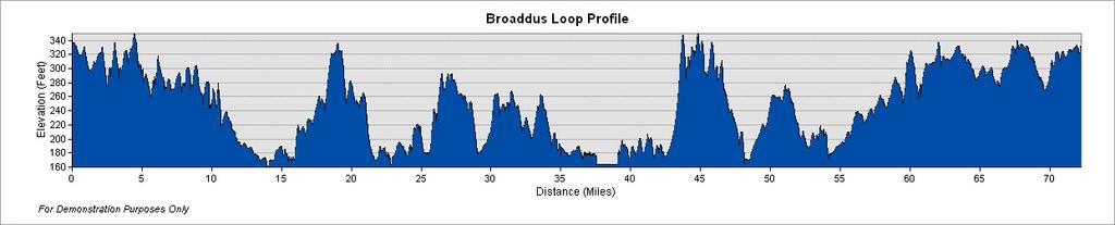
4 Route Summary: The is one of the longest and more advanced routes throughout the surrounding area. This 72.6 mile loop will take cyclist through mostly Angelina County, but will also pass through Nacogdoches and San Augustine County. The route hosts a variety of scenic features that include farm and pastureland, pine and hardwood forests, and waterfront. This route begins with rolling hills that will provide cyclist the opportunity to get warmed up for the rest of the ride. The route then travels through the Angelina National Forest where riders can experience the natural setting of the Pineywoods Region of East Texas. The route is relatively flat until you get closer to Zavalla, Texas. Then the most challenging section of the loop begins with multiple steep climbs up what the local residents refer to as Moss Hill. After this grueling climb cyclist can rest assured that they are on the downhill portion of the ride as they continue on through beautiful pine stands managed by the United States Forest Service. Cyclist will then ride through Huntington, Texas which is the last rest stop before pushing on to the final stretch. After Huntington cyclist will experience a pleasant ride through East Texas ranch country. This section is smooth and flat, and will bring riders back into Lufkin. Start/Finish: This route begins at Lufkin High School at 309 S. Medford Drive. There is plenty of parking next to the football stadium. During the months when students are not attending classes parking should not be an issue, but when students are attending classes cyclist are encouraged to contact the school s police department at (936) to inquire about parking accommodations. If cyclists need to use the restroom or pick up supplies before departing, it is suggested that they use the Loves Truck Stop located just south of the departure point at the corner of FM 841/Ford Chapel Road and Loop 287/Medford Drive. If you are traveling north on Loop 287/Medford Drive you will exit FM 841/Ford Chapel Road which will take you right past the Loves Truck Stop. Resources: It is advised that all cyclists obtain the appropriate food and water resources before departing. Distances between commercial resources to restock can be vast, and therefore can result in an unpleasant experience if cyclists are not prepared. There are convenience stores located throughout the route in the more populated areas, and are identified on the map. Riders should plan to utilize these resources in order to rest, refuel, and use the restroom.
5 Areas of Interest: Lake Sam Rayburn A crown jewel here in Angelina County is Lake Sam Rayburn Reservoir that is owned and operated by the United States Army Corp of Engineers. This lake intersects five counties and encompasses 750 miles of shoreline. The takes riders around a great portion of the lake, and provides numerous places to enjoy scenic lakeside vistas. Historical Markers There are two Texas Historical Markers along the route that detail the history of the area. One is located just before the first State Highway 103 bridge and provides insight into the Ewing Logging Town that was situated there in The other is located on FM 2109 at the intersection of FM This marker features information about Joseph Herrington who was very influential in the creation of Angelina County. Parks and Recreational Areas There are numerous parks and recreational areas that are situated on Lake Sam Rayburn that are just a short distance from the Broaddus Loop. These areas provide great views of the lake, restroom facilities, and places to rest and regroup before continuing the route. They are all owned by the Army Corp of Engineers but some are operated by other entities. For instance, Shirley Creek and Jackson Hill Marinas are privately operated, Townsend Recreational Area is operated by the United States Forest Service, Cassels Boykin is operated by Angelina County, and Hanks Creek is the only one operated by the Corp of Engineers itself. Special Considerations: Angelina County offers great opportunities for cyclist to experience the Pineywoods Region of East Texas. However, there are special considerations that need to be taken in order to ensure a pleasant and memorable ride. Such considerations include numerous water crossings, narrow roads, and agricultural activities. Water Crossings Angelina County is fortunate to have many streams, rivers, and lakes but this can cause unsafe road conditions for cyclist. The narrow bridges that cross these features often have no shoulders which can lead to close interactions between motorists and cyclists. The most notable for this particular route are the long bridges that cross Lake Sam Rayburn. Narrow Roads With the exception of Highway 103 and Highway 147, the other Farm-to Market Roads do not provide a wide shoulder for cyclist to ride on. These roads can also have narrow turns that limit visibility, and have rough surfaces. Cyclists are encouraged to ride single file when encountering these obstacles. Agricultural Activities Farming, ranching, and logging are important economic activities that occur throughout Angelina County. These industries require large trucks that haul substantial loads; especially on the narrow Farm-to Market Roads. These large trucks make it difficult to provide plenty of room for cyclist, and they can often times shed various debris. Cyclists are encouraged to ride with a mirror so they can see these obstacles coming.
6 Disclaimer: The Lufkin Convention and Visitors Bureau, and its affiliates, assume no responsibility to the cyclists who wish to partake in this activity. They also do not provide any guarantees regarding the accuracy of the proposed mileage and road conditions. Every cyclist is responsible for confirming the route and ensuring their own safety. The proposed route does utilize public roads that are open to motor vehicle traffic, and therefore cyclists should obey all traffic laws and ride at their own risk. It is highly recommended that all cyclists use extreme caution when riding, wear helmets, and have rear view mirrors. Despite the convenience stores located on this route, cyclist should still carry their own food and water, emergency supplies, cell phone, and some form of personal identification. Climatic conditions can also change suddenly and therefore cyclist should plan accordingly. Always let someone know where you are going and your approximate departure and arrival times. Enjoy the Ride! For any comments or updates to this ride, please contact Aaron Friar, LCVB Trails Coordinator at or
Shawnee Prairie Loop. Lufkin & Angelina County Bicycle Route. Total Miles: 38.
 Lufkin & Angelina County Bicycle Route Total Miles: 38 www.visitlufkin.com Route Directions: Segment Distance (miles) Direction of Turn Road Traveled Total Distance (miles) Start Lufkin High School (309
Group Riding Techniques
 Group Riding Techniques Revised: 2017 01 26 A. Group Riding Terminology Thanks to the Ottawa Bicycle Club for allowing us to use content from their website! A.1 Groups and Packs A group is several cyclists
Calaveras Big Trees State Park--South Grove Loop
 Copyright 1999 by Jeff Robinson. You are free to use and reproduce this description for personal, not-for-profit, and not-forbusiness use. Any reproduction other than for personal use, including businesses,
Description of Road Management Objectives, Existing Use, and Proposed Use:
 Engineering Report White River National Forest Eagle-Holy Cross Ranger District Analysis of Road # 700 Red Sandstone Road for Motorized Mixed Use Designation Page 1 of 12 Forest: White River District:
Application to AASHTO to recognize six suggested relocations of U.S. Bicycle Route 1 in the Northern Virginia District.
 September 7 th, 2007 Application to AASHTO to recognize six suggested relocations of U.S. Bicycle Route 1 in the Northern Virginia District. Acting District Administrator Mr. Morteza Salehi has endorsed
Bikeability Checklist
 Bikeability Checklist How bikeable is your community? Riding a bike is fun! Bicycling is a great way to get around and to get your daily dose of physical activity. It's good for the environment, and it
2017 Relay Team Handbook
 2017 Relay Team Handbook Race Date: April 23, 2017 (Updated 4/05/17) PRESENTED BY Welcome to the Mt. Si Relay 2017 This booklet contains important information for the 34th Annual Mt. Si Relay, April 23,
Traffic Signs and Signals
 CHAPTER FOUR Traffic Signs and Signals Traffic signs control traffic flow, making streets and highways safer for drivers, bicyclists and pedestrians. These signs, which are posted by the Indiana Department
2.0 Existing Conditions
 20 2.0 Existing Conditions 2.1 Land Use, Future Growth Patterns, Physical Barriers Geographic Overview Sutter County s land use pattern is characterized by extensive agricultural areas, significant natural
Signs. signs, signals and road markings. in this chapter
 3 signs, signals and road markings in this chapter Signs regulatory signs school, playground and crosswalk signs lane use signs turn control signs parking signs reserved lane signs warning signs object
Heartwood Forest, in Sandridge, Hertfordshire, is a place where everyone can find space, peace, wildlife and miles of beautiful woodland to explore.
 Heartwood Forest Accessibility Statement September 2016 Purpose: This accessibility statement outlines the available facilities and access information for Heartwood Forest. Welcome We, the Woodland Trust,
DRAFT. System Components. Greenway Trails. Introduction. Trail Types. Zebulon Greenway Master Plan
 5 System Components Wakefield Street Photo Simulation showing Sharrows Introduction The Master Plan identifies various system components that, together, create a comprehensive greenway system. These components
G AT E WAY PLAN. Community BRIEFING KIT GATEWAY BIKE
 G AT E WAY PLAN GATEWAY BIKE Community BRIEFING KIT PLAN August 2016 TABLE OF CONTENTS INTRODUCTION... 1 THE BENEFITS OF A BIKEABLE COMMUNITY... 2 ECONOMY...2 SAFETY...3 HEALTH...3 HOUSEHOLD SPENDING...3
SAFE ROUTES TO SCHOOL
 SAFE ROUTES TO SCHOOL Forest Ridge Elementary School Existing Conditions and ACTION PLAN > Oak Creek - Franklin Joint School District Table of Contents CONTEXT Enrollment Boundaries
Northwest Cycling Club s 2018 Bluebonnet Express. Riders Handbook
 Northwest Cycling Club s 2018 Bluebonnet Express Riders Handbook 2018 marks the 29 th year the Bluebonnet Express ride has been held making it one of the oldest bike rides in the Houston area. The following
To Benefit the Wachusett Mountain Race Team!
 To Benefit the Wachusett Mountain Race Team! Handbook Outline: Race Overview & Events Schedule....3 Leg 1: 5-mile Run... 4 Leg 2: Scenic Bike Race.....5 Leg 3: Summit Climb......6 Leg 4: Ski Run...7 Application.....8
About The Big Bend Open Road Race U.S 285 Course Notes
 2018 About The Big Bend Open Road Race U.S 285 Course Notes Course notes for 2018, Ft. Stockton to Sanderson and return. * Please note that these course notes are based on the 2017 race. You will notice
ADJUSTING TO, FOLLOWING, AND MEETING URBAN TRAFFIC
 Lesson 4 Student Notes 1 ADJUSTING TO, FOLLOWING, AND MEETING URBAN TRAFFIC 1. What two main factors make city driving difficult? There are more cars, buses, trucks, and pedestrians per mile. City hazards
Fish Lake Team Relay Course Information 2016
 Fish Lake Team Relay Course Information 2016 Fish Lake Team Relay Course Information 2016 The Fish Lake Team Relay begins at Fish Lake Lodge on the shores of beautiful Fish Lake located in Sevier County,
Route 28 Critical Locations Bicycling Network Connectivity November 2017
 Route 28 Critical Locations Bicycling Network Connectivity November 2017 Nobska Light Chatham Light Prepared by Cape Cod Commission staff on behalf of the Cape Cod Metropolitan Planning Organization and
Tour de Moore Classic
 Tour de Moore Classic Rider s Guide Classic North Carolina Bike Rides Contents Tour de Moore Classic North Carolina Classic Rides RIDERS GUIDE Welcome Rider Information Schedule of Events Ride Maps History
29 th Annual Army Spring Classic United States Military Academy
 29 th Annual Army Spring Classic United States Military Academy West Point, New York April 13 th and 14 th 2013 Pre-Registration: *Register at Bike Reg.com (Preferred method).* E-Mail: Jennifer.Webster@usma.edu
Spectator Guide. Motor Sport Activities are inherently dangerous recreational activities and there is significant risk of injury, disability or death.
 Please Read 1 Spectators must not stand in prohibited areas, and must at all times stand behind the bunting or barriers which mark the spectator area. 2 The instructions of the Spectator Marshals must
APPENDIX A. GIS ANALYSIS FOR THE MRT
 APPENDIX A. GIS ANALYSIS FOR THE MRT The Iowa Mississippi River Trail plan was created through a data-driven analysis using geographic information systems. GIS integrates map images with relevant data,
Safety Plan. Aspen Backcountry Marathon 8/27/11. City of Aspen Special Events
 Safety Plan Aspen Backcountry Marathon 8/27/11 City of Aspen Special Events INTRODUCTION The purpose of this Plan is to set forth organization, responsibilities, and procedures for the safe conduct of
I-215 / NEWPORT ROAD INTERCHANGE PROJECT PRESS KIT
 I-215 / NEWPORT ROAD INTERCHANGE PROJECT PRESS KIT March I-215 / NEWPORT ROAD INTERCHANGE PROJECT Fact Sheet Project Overview This project will reconstruct the existing interchange located on Interstate
Section 9. Implementation
 Section 9. Implementation The transportation system is just one of many aspects that must be carefully planned to maintain and enhance the quality of living in Cecil County. The Cecil County Bicycle Plan
August 3, Bay Trail Connection With The Community
 Ms. Lina Velasco, Senior Planner City of Richmond Planning Division P.O. Box 4046 Richmond, CA 94804 Dear Ms. Velasco: August 3, 2009 73 Belvedere Ave. Richmond, CA 94801 Phone/Fax: 510-235-2835 Email:tracbaytrail@earthlink.net
RURAL HIGHWAY SHOULDERS THAT ACCOMMODATE BICYCLE AND PEDESTRIAN USE (TxDOT Project ) June 7, Presented by: Karen Dixon, Ph.D., P.E.
 June 7, Presented by: Karen Dixon, Ph.D., P.E.") RURAL HIGHWAY SHOULDERS THAT ACCOMMODATE BICYCLE AND PEDESTRIAN USE (TxDOT Project 0-6840) June 7, 2016 Presented by: Karen Dixon, Ph.D., P.E., TTI Team: Kay Fitzpatrick, Raul Avelar, & Subasish Das Project
RURAL HIGHWAY SHOULDERS THAT ACCOMMODATE BICYCLE AND PEDESTRIAN USE (TxDOT Project 0-6840) June 7, 2016 Presented by: Karen Dixon, Ph.D., P.E., TTI Team: Kay Fitzpatrick, Raul Avelar, & Subasish Das Project
Ohio Share the Road Driver s s Education Unit
 Ohio Share the Road Driver s s Education Unit Bicyclists are Drivers of Vehicles 4501.01. Definitions (A) "Vehicle" means every device, including a motorized bicycle, in, upon, or by which any person or
Arlington County Police Department Law Enforcement Guide. Enforcing Bicycle Traffic Laws
 Arlington County Police Department Law Enforcement Guide Enforcing Bicycle Traffic Laws Arlington County Police Department Safe Bicycling Initiative 2016 About the Arlington Safe Bicycling Initiative The
Tour de Wyoming 2015 Route Overview:
 Tour de Wyoming 2015 Route Overview: Route Overview: Gather in Sundance on July 11 Day 1 (July 12): Sundance to Newcastle via Upton Day 2 (July 13): Newcastle to Custer via Wind Cave NP Day 3 (July 14):
APPENDIX D LEVEL OF TRAFFIC STRESS METHODOLOGY
 APPENDIX D LEVEL OF TRAFFIC STRESS METHODOLOGY 01 WHAT IS LEVEL OF TRAFFIC STRESS? When people bicycle on roadways, they encounter varying levels of stress from traffic. A quiet residential street with
Trail and Driving Directions
 Trail and Driving Directions GETTING TO THE START: FROM CADILLAC: Follow M-55 west from US131 for 20.9 miles to the corner of M-37 and M-55 FROM THE INTERSECTION OF M-55 AND M-37: Head west on M-55 2.7
Kentucky s Surface Transportation System
 Kentucky s Surface Transportation System ROAD AND BRIDGE CONDITIONS, TRAFFIC SAFETY, TRAVEL TRENDS, AND NEEDS MARCH 2018 PREPARED BY WWW.TRIPNET.ORG Founded in 1971, TRIP of Washington, DC, is a nonprofit
AASHTO Use Only Establishment of a U.S. (Interstate) Route IH 69 Action taken by SCOH: Extension of a U.S. (Interstate)Route
 Route IH 69 Action taken by SCOH: Extension of a U.S. (Interstate)Route") American Association of State Highway and Transportation Officials An Application from the State Highway or Transportation Department of Texas for: Elimination of a U.S. (Interstate) Route AASHTO Use Only
American Association of State Highway and Transportation Officials An Application from the State Highway or Transportation Department of Texas for: Elimination of a U.S. (Interstate) Route AASHTO Use Only
Everyday Hazards for School Bus Drivers. Reference Guide and Test
 1 Everyday Hazards for School Bus Drivers Reference Guide and Test 2 Introduction One of the most important and often overlooked issues for school bus drivers is hazards. During the course of the video,
Direction of cyclists
 BP MS 150 BIKE RIDE Direction of cyclists SUNDAY MAP 027 START BP MS 150 EXPRESS ROUTE Cyclists go South on HWY77, and then use the Feeder Road to access the shoulder of HWY71. Police will allow riders
Bicycle - Motor Vehicle Collisions on Controlled Access Highways in Arizona
 Bicycle - Motor Vehicle Collisions on Controlled Access Highways in Arizona Analysis from January 1, 1991 to June 30, 2002 Richard C. Moeur, PE Traffic Design Manager, Northern Region Michelle N. Bina
Engineering Report: Apache-Sitgreaves National Forests. Black Mesa Ranger District. Analysis of. National Forest System Roads (NFSRs) #s 504 & 169
 #s 504 & 169") Engineering Report: Apache-Sitgreaves National Forests Black Mesa Ranger District Analysis of National Forest System Roads (NFSRs) #s 504 & 169 for Motorized Mixed Use Designation Forest: Apache-Sitgreaves
Engineering Report: Apache-Sitgreaves National Forests Black Mesa Ranger District Analysis of National Forest System Roads (NFSRs) #s 504 & 169 for Motorized Mixed Use Designation Forest: Apache-Sitgreaves
Developing a Bike/Pedestrian Plan Using ArcInfo and Public Participation Rob Shumowsky, Madison County Council of Governments
 Developing a Bike/Pedestrian Plan Using ArcInfo and Public Participation Rob Shumowsky, Madison County Council of Governments Abstract: The Madison County Council of Governments is creating a bike/pedestrian
Falls Lake Trail (A part of the NC Mountains-to-Sea Trail) East to West
 East to West") Falls Lake Trail (A part of the NC Mountains-to-Sea Trail) East to West Section 1 (Falls of the Neuse Rd to Raven Ridge Rd) 0.0 mi Parking area of the Tailrace Fishing Area, just below the dam, off Falls
Falls Lake Trail (A part of the NC Mountains-to-Sea Trail) East to West Section 1 (Falls of the Neuse Rd to Raven Ridge Rd) 0.0 mi Parking area of the Tailrace Fishing Area, just below the dam, off Falls
APPENDIX 1 CITY OF CALGARY SHARE THE PATHWAY PROGRAM
 APPENDICES APPENDIX 1 CITY OF CALGARY SHARE THE PATHWAY PROGRAM Share the Pathway Share the pathway and share the responsibilities. Those who use the pathway get along better when they show courtesy and
Bicycling Routes on Provincial Roads Policy
 Bicycling Routes on Provincial Roads Policy Policy Statement Rationale To support bicycling in Nova Scotia, the Department of Transportation and Infrastructure Renewal (TIR) may designate some portions
Review of Guidelines for Cycleway Safety Fencing
 Review of Guidelines for Cycleway 1.0 PURPOSE 1.1 This document is meant to provide a review of available reference documents for determining appropriate fencing requirements for cycleway paths and shared
State Route 28 Shared Use Path & Safety/Stormwater Enhancements Public Information Meeting
 State Route 28 Shared Use Path & Safety/Stormwater Enhancements Public Information Meeting Thursday, March 30, 2017 4-7 p.m. Presentation at 5:30 p.m. The Chateau at Incline Village 955 Fairway Blvd. Incline
Lee s Summit Road Improvement Study Public Open House June 7, 2007 Summary of Comment Card Responses
 Lee s Summit Road Improvement Study Public Open House June 7, 2007 Summary of Comment Card Responses Introduction At the Lee s Summit Road Improvement Study Public Open House held Thursday, June 7, 2007
CITY OF ELKO BICYCLE AND PATHWAY PLAN
 CITY OF ELKO BICYCLE AND PATHWAY PLAN INTRODUCTION: The City of Elko is intended to provide the basic framework for the development of a functional bicycle and pathway system for the community with connections
Jersey Shore Touring Society Rider Guidelines Revision 1.0 Last Updated 5/9/2008
 Jersey Shore Touring Society Rider Guidelines Revision 1.0 Last Updated 5/9/2008 Version History VERSION NUMBER REVISION DATE EDITOR SUMMARY OF CHANGE 0.1 3/5/2008 Laury Wills Initial Draft 0.2 3/11/2008
Birmingham Bicycle Club
 Birmingham Bicycle Club Ride Leader Guidelines Thank you for your interest in leading a ride for the Birmingham Bicycle Club! Group rides are a major offering of our club. Ride leaders provide the opportunity
Jackson Hog 2496 ROAD CAPTAIN HANDBOOK TABLE OF CONTENTS. Introduction 2. Objectives 2. Road Captain Qualifications 3
 Jackson Hog 2496 TABLE OF CONTENTS Introduction 2 Objectives 2 Road Captain Qualifications 3 Highly Recommended Qualifications 3 Road Captain Responsibilities 4 Road Captain Guidelines 5 Lead Road Captain
2014 USA Cycling Mt. Bike Marathon National Championships Operation Plan
 Operations Plan 2014 USA Cycling Mt. Bike Marathon National Championships Operation Plan Overview. 3 Trail Construction.4 Event Communications. 5 Medical Plan. 6 Crowd Control.7 Parking.8 Onsite Facilities...9
The five potential solutions and some of their benefits and costs are listed in the following table: Ferry Patron Bike Parking Alternatives
 STAFF REPORT City Council of the City of Sausalito AGENDA TITLE: Ferry Patron Bicycle Parking Plan - Summer 2014 RECOMMENDED MOTION: Note and file informational item, no action necessary SUMMARY In April
NORTH HIGHLAND LAKE ROAD PROJECT
 NORTH HIGHLAND LAKE ROAD PROJECT The purpose of this special newsletter is to inform the residents of Flat Rock about the facts concerning the proposed N. Highland Lake Road Project and clarify some misconceptions.
Bicyclists and Truck Driver Visibility
 Bicyclists and Truck Driver Visibility Posting Date: 08-Aug 2014 On August 7th, 2014 a 19-year-old female cyclist was killed when her bicycle was run over by a concrete mixer truck at the intersection
29th Running of the Ouachita Trail 50 Endurance Run April 13, 2019 Race Information
 29th Running of the Ouachita Trail 50 Endurance Run April 13, 2019 Race Information The Basics Location: Starting Time: Packets: Race Detail Maumelle Park, Little Rock, Arkansas, Pavilion # 8 (see map
RICHMOND BICYCLE AND PEDESTRIAN PLAN. September 2014 Prepared by the Midcoast Council of Governments
 2578 RICHMOND BICYCLE AND PEDESTRIAN PLAN September 2014 Prepared by the Midcoast Council of Governments Introduction Bicycle and pedestrian activity is an important factor of a successful village center.
Trail Notes Local Mountain Bike Areas
 Trail Notes Local Mountain Bike Areas Campus Recreation 875 Perimeter Drive MS 1230 Moscow. Idaho 83844-1230 Ph: 208.885.6810 Rentals: 208.885.6170 Fax: 208.885.6879 uidaho.edu/outdoorprogram 1 Table of
Bicycle Safety Skills
 Bicycle Safety Skills Presented by: MassBike Cape and Islands Chapter MassBike John Fallender December 20, 2010 Cape & Islands Chapter 1 Welcome to Cape Cod 2 Bikes are vehicles? What does that mean? That
Welcome Official Categories Everyone and anyone. Minimum of 3 males and 3 females 50% of the team must be employed at the same business/company
 Welcome You won t find another race like the Klondike Trail of 98 International Road Relay. It offers breath-taking scenery, team camaraderie, physical challenge and gracious northern hospitality. This
Parental Responsibilities
 Bicycle riding is a fun way to exercise and enjoy the outdoors. To remain safe on Illinois roads, bicyclists must obey the same traffic safety laws that govern vehicle drivers. No amount of bicycle safety
Fish Lake Team Relay Course Information
 Fish Lake Team Relay Course Information Fish Lake Team Relay Course Information The Fish Lake Team Relay begins at Fish Lake Lodge on the shores of beautiful Fish Lake located in Sevier County, Utah. The
SAN FRANCISCO MUNICIPAL TRANSPORTATION AGENCY
 THIS PRINT COVERS CALENDAR ITEM NO. : 11 DIVISION: Sustainable Streets BRIEF DESCRIPTION: SAN FRANCISCO MUNICIPAL TRANSPORTATION AGENCY Approving traffic modifications on Twin Peaks Boulevard between Christmas
distance 96km (60m) easy
 easy") Experience Rating easy distance 96km (60m) Cycling route: 96km (60 miles) Cycling in: The Great Waterway, Stormont, Dundas and Glengarry Number of days cycling: 2 Recommended number of nights stay: 2 Experience
Experience Rating easy distance 96km (60m) Cycling route: 96km (60 miles) Cycling in: The Great Waterway, Stormont, Dundas and Glengarry Number of days cycling: 2 Recommended number of nights stay: 2 Experience
Gravel Bike Guide Haywood County
 Gravel Bike Guide Haywood County Haywood County is an ideal place for bicycling on gravel roads, because 37% or 129,994 acres of Haywood County is federal property, including portions of the Pisgah National
distance Easy/Moderate
 Experience Rating Easy/Moderate distance 40km (25m) Cycling route: 40km (25 miles) Cycling in: The Great Waterway, Prince Edward County Number of days cycling: 1 Recommended number of nights stay: 2 Experience
Bicycles and Pedestrians on ISU Campus. Indiana State University Police
 Bicycles and Pedestrians on ISU Campus Indiana State University Police FASTEST Transportation On Campus There has been an increase in cyclists and pedestrians on campus as student enrollment continues
2017 Crew Manual Alternate Route Race Day - February 18, 2017
 2017 Crew Manual Alternate Route Race Day - February 18, 2017 Crew Rules Crewing is a privilege not a right at this race. We ask that you follow these simple rules to help keep our race safe and enjoyable
Tour de Chip Seal. Tour de Chip Seal Follow- up Report and Conclusions May 16, 2013
 Tour de Chip Seal Follow- up Report and Conclusions May 16, 2013 Old Jackson Highway, Victor Idaho Tour de Chip Seal Teton County Idaho and Teton County Wyoming May 16, 2013 1. Old Jackson Highway, North
Bikeability Checklist
 Bikeability Checklist How bikeable is your community? Riding a bike is fun! Bicycling is a great way to get around and to get your daily dose of physical activity. It's good for the environment, and it
When on the road When turning When avoiding hazards. This is NOT a straight line: This is NOT a straight line: This is NOT a straight line:
 RIDE IN A STRAIGHT LINE When on the road When turning When avoiding hazards This is NOT a straight line: This is NOT a straight line: This is NOT a straight line: STAY TOGETHER No more than bike length
Act 47 Exception Application Process (Permitting Bicycle Travel on Freeways)
") Act 47 Exception Application Process (Permitting Bicycle Travel on Freeways) Attached is a revised application process to permit Pedalcycle travel on the shoulders of freeways within the Commonwealth.
Act 47 Exception Application Process (Permitting Bicycle Travel on Freeways) Attached is a revised application process to permit Pedalcycle travel on the shoulders of freeways within the Commonwealth.
Steaming Nostril & Runny Nose CX/MTB/Fat Bike Cycle for All Race
 Steaming Nostril & Runny Nose CX/MTB/Fat Bike Cycle for All Race Technical Guide Version 1.1 Sunday April 8, 2018 Waterloo Rod & Gun Club, St. Jacobs, Ontario Runny Nose 40km 10:40 am Steaming Nostril
May 19, 2018 RADIO OPERATIONS PLAN
 PACIFIC CREST TRAIL 50 MILE RUN May 19, 2018 RADIO OPERATIONS PLAN Run Website - http://www.pct50.com/ Race Director - John Martinez Communications Coordinator - Craig Williams W6CAW. 619-806-4146 craig@craigwilliams.com
TRAFFIC ALERT FOR FEBRUARY 26 to MARCH 2, 2018 Highway Work Zones in the Staunton District
 RELEASE: IMMEDIATE February 23, 2018 CONTACT: Sandy Myers 540-332-9201 (office) STA18-039 540-292-2500 (cell) Sandy.Myers@VDOT.virginia.gov Ken Slack 540-332-9264 (office) 540-414-5670 (cell) Ken.Slack@VDOT.virginia.gov
SAN FRANCISCO MUNICIPAL TRANSPORTATION AGENCY
 THIS PRINT COVERS CALENDAR ITEM NO. : 10.3 DIVISION: Sustainable Streets Division BRIEF DESCRIPTION: SAN FRANCISCO MUNICIPAL TRANSPORTATION AGENCY Approving traffic and parking modifications to install
Chapter 11 Highway and Rural Driving
 Chapter 11 Highway and Rural Driving 11-1 THE RURAL DRIVING ENVIRONMENT A. Complete each of the following sentences by writing the correct word or phrase in the space provided. 1. The most heavily traveled
2016 North Country Trail Relay Updated Event Instructions Jan 2016
 Welcome to the 2016 North Country Trail Relay (NCTR). organized by Bev Chesebro and Doug Bostian The race is run on the North Country National Scenic Trail, which is a footpath that one day will stretch
Viaducts, Eastern Core and False Creek Flats Cycling Improvements HUB Vancouver/UBC committee 2013/05/13
 Viaducts, Eastern Core and False Creek Flats Cycling Improvements HUB Vancouver/UBC committee 2013/05/13 Table of Contents Executive Summary Cycling in the Viaducts Area: Current Situation and the City
Beginning School Bus Driver Curriculum UNIT IX. FIELD TRIPS and TRAFFIC CONTROL DEVICES. Revised 09/2011 Revised 10/2013 (Instructional Content)
") Beginning School Bus Driver Curriculum UNIT IX FIELD TRIPS and TRAFFIC CONTROL DEVICES Revised 09/2011 Revised 10/2013 (Instructional Content) Unit IX FIELD TRIPS AND TRAFFIC CONTROL DEVICES TABLE OF CONTENTS
Beginning School Bus Driver Curriculum UNIT IX FIELD TRIPS and TRAFFIC CONTROL DEVICES Revised 09/2011 Revised 10/2013 (Instructional Content) Unit IX FIELD TRIPS AND TRAFFIC CONTROL DEVICES TABLE OF CONTENTS
2014 Participant Guide Around the Mount Triathlon Saturday, April 26th, 8:00 a.m.
 2014 Participant Guide Around the Mount Triathlon Saturday, April 26th, 8:00 a.m. Dear Triathletes, This document is being sent to help communicate the key pieces of information you need to have a fun,
Arlington County Police Department Law Enforcement Guide. Enforcing Bicycle Traffic Laws
 Arlington County Police Department Law Enforcement Guide Enforcing Bicycle Traffic Laws Arlington County Police Department Safe Bicycling Initiative 2017 About the Arlington Safe Bicycling Initiative The
LAGUNA BEACH POLICE DEPARTMENT MEMORANDUM
 LAGUNA BEACH POLICE DEPARTMENT MEMORANDUM TO: FROM: Christa Johnson, Assistant City Manager Jason C. Kravetz, Captain DATE: January 16, 2015 SUBJECT: Laguna Canyon Road Collision Analysis Within the last
Obey Creek PEDESTRIAN CIRCULATION EAST WEST PARTNERS PEDESTRIAN CIRCULATION CREEK SIDE LANE SLIP STREET SCOTT MURRAY MAIN STREETS EAST/WEST
 THE VILLAGE AT PEDESTRIAN CIRCULATION MAIN STREETS NORTH/SOUTH MAIN STREETS EAST/WEST SLIP STREET CREEK SIDE LANE PEDESTRIAN CIRCULATION DESCRIPTION: Circulation through the downtown of is organized by
What are the Qualities that make Newark a Bicycle Friendly Community? What are aspects that make Newark less Bicycle Friendly?
 What are the Qualities that make Newark a Bicycle Friendly Community? Many stores are within biking distance (1) Lots of bike lanes and new trail Existing bike routes (2) Designated bike lanes on Del ave.
GORGE GRAVEL GRINDER 9:00 am - April 7 th The Dalles, Oregon
 GORGE GRAVEL GRINDER 9:00 am - April 7 th The Dalles, Oregon Introduction The Gorge Gravel Grinder is where it all started. Located in The Dalles this eastern Oregon location is the best known for its
1 Identify and explain ten important road signs.
 ROAD SAFETY ADVENTURER AWARD BOOK By Lyn Webb 1 Identify and explain ten important road signs. What does a SPEED LIMITED AREA sign mean? These signs are used to indicate an area where a lower speed limit
Updated August 1, 2016
 5 Updated August 1, 2016 American Association of State Highway and Transportation Officials An Application from the State Highway or Transportation Department of Alabama for: Elimination of a U.S. (Interstate)
T R A F F I C S K IL L S 101
 page 1/5 GENERAL INSTRUCTIONS Mark your answers on the answer sheet provided. DO NOT make any marks on the test. Please read the following definitions and assumptions carefully before answering the test
H 232 Bicycle Safety Report
 April 2016 H 232 Bicycle Safety Report Kevin Lacy and Lauren Presenter Blackburn Name H 232 Working Group Members NC State Highway Patrol Bicycle Shop Owner MPO Representative (2) Agricultural Community
HURL ELKHORN 50K RUN AID STATIONS COURSE MARKINGS
 HURL ELKHORN 50K RUN AID STATIONS The race starts and finishes at Crystal Creek Campground, where primitive camping is available. The race starts at 7:00 am. The finish cut off time is 9:00 pm. No drop
US 69 RELIEF ROUTE STUDY
 US 69 RELIEF ROUTE STUDY Jacksonville, Texas PUBLIC MEETING #2 May 29 th, 2018 Welcome to the public meeting for the US 69 Relief Route Study in Jacksonville. This is the second public meeting for this
Outreach Approach RENEW SF served as the primary liaison with the North Beach community; the Chinatown. Executive Summary
 Executive Summary Executive Summary The Columbus Avenue Neighborhood Transportation Study s objective is to identify changes to transportation infrastructure and policies that could enhance the livability
Bicycle Count Data. December 2008
 Bicycle Count Data December 28 Published By: San Luis Obispo Public Works Department 919 Palm Street, San Luis Obispo, California 9341 Telephone (85) 781 719; FAX (85) 781 7198 www.slocity.org Introduction
and older adults and people with disabilities still face barriers when using the pedestrian network and public transportation.
 Background Afterthe1980Olympics,theLakePlacid/NorthElbacommunityadoptedaneconomicstrategy ofdevelopingandmarketingeventstoincreaseareatourism.thisstrategyhasbeenvery successful.overrecentyearsthevolumeofvisitorshasincreased,andthelengthofthe
PROLOGUE Stage 1 & 2 July 2017 CRITERIUM
 UPDATE PROLOGUE Stage 1 & 2 1 July 2017 CRITERIUM 1 Round 2 Warwick 1 st July Stage One: Prologue Program The prologue is intended to be a short, hard, and fast race against the clock. Starting at one
Section 5: Bike and Pedestrian
 Section 5: Bike and Pedestrian Existing Conditions: One defining feature of Glynn County appreciated by both residents and visitors is the extensive sidewalk and bike path system. The City of Brunswick,
SOLANA BEACH BICYCLE TRANSPORTATION PLAN SECOND ADDENDUM
 SOLANA BEACH BICYCLE TRANSPORTATION PLAN SECOND ADDENDUM Prepared by the City of Solana Beach January 2005 Introduction In June of 1993, the Solana Beach City Council adopted a Bikeway Master Plan as directed
Chapter 3 DESIGN SPECIFICATIONS
 Brampton PathWays Planning and Design Guidelines 27 Chapter 3 DESIGN SPECIFICATIONS 3.1 CLASS 1 MULTI-USE PATH Off-road multi-use trails are the backbone of the Brampton PathWays Network. They are typically
GROUP RIDING STANDARDS and ROAD CAPTAIN GUIDELINES
 GROUP RIDING STANDARDS and ROAD CAPTAIN GUIDELINES Table of Contents Section Title 01.0 WELCOME 02.0 ALL GROUP RIDER'S RESPONSIBILITIES 03.0 MEETING PLACES AND DEPARTURE TIMES 04.0 RIDING FORMATION AND