4 & 4A Oaklands Road, Bromley, BR1 3SL TRANSPORT ASSESSMENT
|
|
|
- Cecil Lindsey
- 5 years ago
- Views:
Transcription

1 4 & 4A Oaklands Road, Bromley, BR1 3SL TRANSPORT ASSESSMENT Oaklands January 2015
2 4 & 4A Oaklands Road, Bromley, BR1 3SL TRANSPORT ASSESSMENT Oaklands January 2015 Registered Company Address: Mansion House Manchester Road Altrincham Cheshire WA14 4RW Tel: Postal Address; C/O 20 Timber Street South Wigston Leicester LE18 4QF COPYRIGHT: The concepts and information contained in this document are the property of. Use or copying of this document in whole or in part without the written permission of Sarnlea constitutes an infringement of copyright. LIMITATION: This report has been prepared on behalf of and for the exclusive use of Sarnlea Limited s Client, and is subject to and issued in connection with the provisions of the agreement between Sarnlea and its Client. accepts no liability or responsibility whatsoever for or in respect of any use of or reliance upon this report by any third party.
3 Appendices Appendix A Appendix B PTAL Report Swept Path Analysis Suite C:\Users\Alistair\Documents\\Projects\Oaklands\Reports Final\ FINAL.docx PAGE i
4 Figures Figure 1 Figure 2 Figure 3 Figure 4 Figure 5 Figure 6 Site Location Plan Red Line Boundary Plan Local Highway Network Walking Isochrone Cycling Isochrone Site Layout Plan C:\Users\Alistair\Documents\\Projects\Oaklands\Reports Final\ FINAL.docx PAGE ii
5 Tables Table 1 Table 2 Table 3 NTS Journey Purpose Split NTS Person Trip Rates Development Vehicular Trip Rates C:\Users\Alistair\Documents\\Projects\Oaklands\Reports Final\ FINAL.docx PAGE iii
6 Contents 1. Introduction 1 2. Background Site Location & Application Context 2 3. Existing Conditions Local Highway Network Public Transport Appraisal Walking Appraisal Cycling Appraisal 5 4. National and Local Policy National Policy Local Policy 9 5. Proposed Development Development Description Proposed Access Strategy & Internal Site Layout Car Parking Provision Development Traffic Generation Summary and Conclusions 13 C:\Users\Alistair\Documents\\Projects\Oaklands\Reports Final\ FINAL.docx PAGE iv
7 Document history and status Revision Date issued Reviewed by Approved by Date approved Revision type Draft AJRM AJRM Draft Final AJRM/NS AJRM Final Distribution of copies Revision Copy no Quantity Issued to Draft (electronic) NS (SEL) Final (electronic) NS (SEL) Printed: 25 January 2015 Last saved: File name: Author: Project manager: Name of organisation: Name of project: Name of document: Document version: Project number: 25 January :38 PM AJRM AJRM South East Living Oaklands Transport Assessment Final ENG/SEL/003 C:\Users\Alistair\Documents\\Projects\Oaklands\Reports Final\ FINAL.docx PAGE v
8 1. Introduction 1.1 Summary This Transport Assessment has been prepared by on behalf of South East Living (SEL) in order to support the forthcoming outline planning application at 4 & 4A Oaklands Road, Bromley, BR1 3SL Outline planning permission is sought for: Development of 11 No one and two bedroom apartments The Transport Assessment is structured as follows: Section 2.0 outlines the background to the proposed development; Section 3.0 considers the existing conditions of, and around the site. This section also looks at the baseline transport data on which the assessment is based. It gives the relevant details of the local highway network surrounding the site and assesses the accessibility levels of the site via modes of transport other than the private car; Section 4.0 details the national and local policy considerations relevant to the development site and land use proposed; Section 5.0 looks at the proposed development in detail by giving regard to the proposed access strategy and the site s internal layout; Section 6.0 evaluates the impact of Traffic Generation associated with the proposal; and Section 7.0 includes a summary and draws together the conclusions of the assessment. C:\Users\Alistair\Documents\\Projects\Oaklands\Reports Final\ FINAL.docx PAGE 1
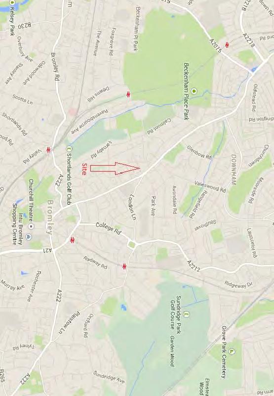
9 2. Background 2.1 Site Location & Application Context The site is located at the eastern end of Oaklands Road, close to the A21 and less than 1 km from Bromley town centre. The existing site is occupied by a substantial three storey building divided into two large 2/3 bed apartments which will be demolished. The total site area equates to hectares. A site location Plan can be seen as Figure The Red Line boundary of the application site can be seen as Figure The site lies within a location characterised by residential dwellings and as such, falls within a prime location to support such a use There is no pertinent planning history to the site in terms of transport planning/highways issues. C:\Users\Alistair\Documents\\Projects\Oaklands\Reports Final\ FINAL.docx PAGE 2
10 3. Existing Conditions 3.1 Local Highway Network Oaklands Road forms a single carriageway two lane highway of some 7.6m width. Oaklands Road is a local access road and provides links to the surrounding local highway network Approximately 85m to the north east of the site, Oaklands Road forms a simple priority Give Way junction with the A21 London Road The A21 forms part of the Transport for London Road Network (TLRN) for which Transport for London TfL are the Highway Authority The A21 forms a major arterial route within London running from Junction 4 of the M25 in the south east to Greenwich in the north A plan showing the local highway network can be found as Figure Public Transport Appraisal The site has a Public Transport Accessibility Level (PTAL) of 2 and is therefore considered to have a Poor level of accessibility to local public transport links. The full TfL PTAL report can be found in Appendix A The first stage in PTAL calculation is to calculate the walking distance from the site (known as the point of interest (POI)) to the nearest bus stops and rail stations (where rail can be taken to also include London Underground, DLR and trams). These stops and stations are known as service access points (SAPs)'. Only SAPs within a certain distance of the POI are included (640m for bus stops and 960m for rail stations, which correspond to a walking time of 8 minutes and 12 minutes respectively at the standard assumed walking speed of 80m/min) The next stage is to determine the service level during the morning peak (defined as ) for each route serving a SAP. Where service levels differ in each direction on a route, the highest frequency is taken. On railways, a route is generally defined as a service with a particular calling pattern - for example, services on the Piccadilly line from Hammersmith could be divided into two "routes": Cockfosters to Heathrow and Cockfosters to Uxbridge. C:\Users\Alistair\Documents\\Projects\Oaklands\Reports Final\ FINAL.docx PAGE 3
11 3.2.4 A total access time for each route is then calculated by adding together the walking time from the POI to the SAP and the average waiting time for services on the route (i.e. half the headway). This is converted to an equivalent doorstep frequency (EDF) by dividing 30 (minutes) by the total access time, which is intended to convert total access time to a "notional average waiting time, as though the route were available at the doorstep of the POI" A weighting is applied to each route to simulate the enhanced reliability and attractiveness of a route with a higher frequency over other routes. For each mode (e.g. bus, Tube, DLR, tram, rail), the route with the highest frequency is given a weighting of 1.0, with all other routes in that mode weighted at Finally, the EDF and the weighting are multiplied to produce an accessibility index for each route, and the accessibility indices for all routes are summed to produce an overall accessibility index for the POI This accessibility index (AI) can then be converted to a PTAL grade (1-6) through a banding system (where AIs are PTAL 1, are PTAL 2, etc, up to PTAL 6 for scores of 25 and above). C:\Users\Alistair\Documents\\Projects\Oaklands\Reports Final\ FINAL.docx PAGE 4
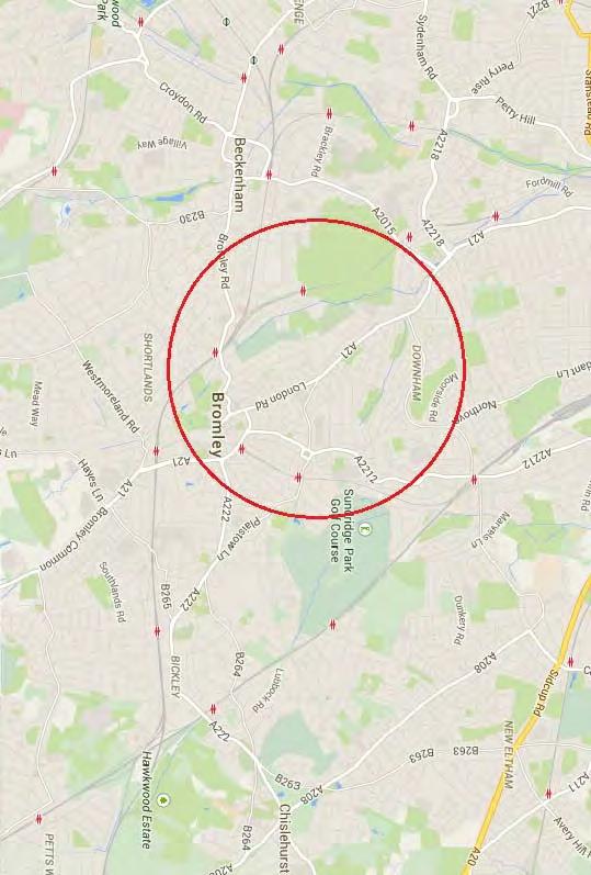
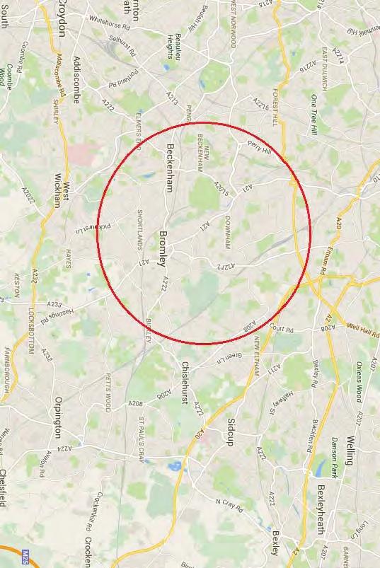
12 3.3 Walking Appraisal According to the Institute of Highways and Transportation (IHT), approximately 80% of walk journeys and walk stages in urban areas are less than one mile. The average length of a walk journey is one kilometre (0.6 miles). This differs little by age or sex and has remained constant since 1975/76. However, this varies according to location. The main factors that influence both walking distance and walking time in a city or town centre appear to be the size of the city or town itself, and the shape and quality of the pedestrianised area An average walking speed of 1.4m/s can be assumed, which equates to approximately 400m in 5 minutes or 3 miles per hour. The situation of people with mobility difficulties must be kept in mind when applying these figures A distance of 1000m for a walking journey or stage is deemed as acceptable, with a preferred maximum of 2000m A metre band can be seen in Figure 4, which illustrates the localities within an acceptable walking distance of the site. 3.4 Cycling Appraisal The acceptable cycling distance to new developments is regarded as being 4km, although many commuters travelling by bike will cycle much further distances than this, the Department for Transport (DFT) considers 4km as the acceptable distance. Figure 5 illustrates the 4km band around the site and shows the localities that it covers. C:\Users\Alistair\Documents\\Projects\Oaklands\Reports Final\ FINAL.docx PAGE 5
13 4. National and Local Policy 4.1 National Policy In 1998 the Government published a White Paper entitled A New Deal for Transport: Better for everyone. Within this document, the Government set out its integrated transport policy to reduce the need to travel, to tackle congestion and pollution, and to support a strong economy, a sustainable environment and a healthy and inclusive society As such, the Government is committed to developing an integrated transport policy for the various regional areas throughout the United Kingdom. There is a widely recognised need to reduce the dependence on the private car through encouraging the use of public transport In the context of transportation, there are a number of goals which are relevant to the consideration of the transport impact of the development proposal. These are: Making the best use of existing roads for all users; Reducing the number of accidents and improving safety on the road network; Restraining private car based commuting; Encouraging responsible car usage and promoting public transport, walking and cycling; Improving the road network to assist public transport services; Providing for the needs of the mobility impaired; and Improving the choice of transport available, especially for disabled people and those without a car All developments should be progressed with reference to the transport requirements of the National Planning Policy Framework (NPPF) national Planning Policy Guidance note (PPG 13). The core documents from a transport perspective are the NPPF, and PPG13 Transport. In essence, these documents state the same primary objective for sustainable methods of transport, namely; To promote more sustainable transport choices for people; C:\Users\Alistair\Documents\\Projects\Oaklands\Reports Final\ FINAL.docx PAGE 6
14 To promote accessibility to jobs and services by public transport, walking and cycling; and To reduce the need to travel, especially by private car The central objectives of PPG13 are set out in paragraph 4 and are to: Integrate planning and transport at the national, regional, strategic and local level to: promote more sustainable transport choices for both people and for moving freight; promote accessibility to jobs, shopping, leisure facilities and services by public transport, walking and cycling; and reduce the need to travel, especially by car Paragraph 6 of PPG13 sets out a series of objectives for Local Planning Authorities in terms of the preparation of development plans. These include the need to: actively manage the pattern of urban growth to make the fullest use of public transport, and focus major generators of travel demand in city, town and district centres and near to major public transport interchanges; ensure that strategies in the development and Local Transport Plan complement each other and that consideration of development plan allocations and local transport investment and priorities are closely linked; use parking policies, alongside other planning and transport measures, to promote sustainable choices and reduce reliance on the car for work and other journeys;.. C:\Users\Alistair\Documents\\Projects\Oaklands\Reports Final\ FINAL.docx PAGE 7
15 4.1.7 The new National Planning Policy Framework (NPPF) sets out 12 core planning principles which include; to encourage the effective use of land by reusing land that has been previously developed (brownfield land), provided that it is not of high environmental value; actively manage patterns of growth to make the fullest possible use of public transport, walking and cycling, and focus significant development in locations which are or can be made sustainable; The NPPF sets a strategy for promoting sustainable transport. It requires that decisions should take account of whether: the opportunities for sustainable transport modes have been taken up depending on the nature and location of the site, to reduce the need for major transport infrastructure; safe and suitable access to the site can be achieved for all people; and; improvements can be undertaken within the transport network that cost effectively limits the significant impacts of the development. Development should only be prevented or refused on transport grounds where the residual cumulative impacts of development are severe Developments should be located and designed where practical to; accommodate the efficient delivery of goods and supplies; give priority to pedestrian and cycle movements, and have access to high quality public transport facilities; C:\Users\Alistair\Documents\\Projects\Oaklands\Reports Final\ FINAL.docx PAGE 8
16 create safe and secure layouts which minimise conflicts between traffic and cyclists or pedestrians, avoiding street clutter and where appropriate establishing home zones; consider the needs of people with disabilities by all modes of transport. 4.2 Local Policy Policy T3 of the Local Development Plan states that off street parking spaces in new development will be expected to be provided at levels no higher than the parking standards set out in Appendix II Policy T7 of the Local Development Plan states that In determining planning applications, the Council will consider as appropriate the potential impact on cyclists and their safety and will seek provision of suitable facilities, including cycle parking/storage to the standards set within Appendix II, and contributions to the provision of the Strategic and Local Cycle Networks as identified on the Proposal Map Policy T17 of the Local Development Plan states that when considering proposals for the redevelopment of frontages within town Centre s or development in other areas where servicing problems arise, the Council will normally require that rear-servicing facilities be provided Policy T18 of the Local Development Plan states that in determining planning applications, the Council will consider as appropriate the potential impact on road safety and will seek to ensure road safety is not adversely affected. C:\Users\Alistair\Documents\\Projects\Oaklands\Reports Final\ FINAL.docx PAGE 9
17 5. Proposed Development 5.1 Development Description Outline planning permission is sought for: Development of 11 No one and two bedroom apartments The 11 dwellings will consist of 7 x one bedroom and 4 x 2 bedroom dwellings The site layout plan can be seen as Figure Proposed Access Strategy & Internal Site Layout Two accesses currently serve the existing site. One of these will be closed off with the kerb reinstated, and the other will remain as the singular vehicular, pedestrian and cyclist access to the parking forecourt at the rear of the site The access driveway ranges in width from 4.8m at its widest to 3.1m at its narrowest. In line with Manual for Streets, this is widest enough for two vehicles to pass within the site and wide enough for vehicles and pedestrians and cyclist to pass in a safe manner A bin store is located to the front of the site and refuse collection will take place on-street A suite of swept path analysis drawings demonstrating the suitability of the development s site layout and access can be seen in Appendix B. 5.3 Car Parking Provision parking spaces are provided within the development as a whole. Each residential dwelling is to be provided with 1 space including 1 dedicated disabled parking bay London Borough of Bromley parking standards dictate a maximum provision of 1 space per residential unit, which the proposed level of parking provision meets The level of provision is also in accordance with Chapter 6 of the London Plan The rear parking court provides 10 spaces. The dedicated disabled parking bay lies to the front of the site and accessed off the access driveway. C:\Users\Alistair\Documents\\Projects\Oaklands\Reports Final\ FINAL.docx PAGE 10
18 6. Development Traffic Generation For developments consisting of a limited number of residential dwellings in such a location as Bromley it is not appropriate to make use of the TRICS database to determine an appropriate dataset, but to utilise the accepted National Travel Survey (NTS) The most recent NTS with full data results undertaken in 2010 determined that for residential dwellings the typical trip rates are broken down as follows: TABLE 1: NTS Journey Purpose Split Journey Purpose Commuting and Business 28% 39% Education/Escort Education 47% 3% Shopping 5% 12% Personal Business 14% 20% Leisure 6% 26% Typical expected trip rates per household are as follows: TABLE 2: NTS Person Trip Rates Arrivals Departures Totals AM Peak PM Peak The above trip rates are person trip rates, so taking an extremely robust position assumption that 100% of all person trips are made by individual private vehicle the following vehicular trip rates would be seen: C:\Users\Alistair\Documents\\Projects\Oaklands\Reports Final\ FINAL.docx PAGE 11
19 TABLE 3: Development Vehicular Trip Rates Arrivals Departures Totals AM Peak PM Peak Clearly, the above assumption and estimations are extremely robust. Notwithstanding the robust assessment, the above vehicular trip rates are at a level as to be classed as immaterial in traffic impact terms The existing use generates in the region of 4 vehicular trips during the peak hours A nett total of 10 vehicular movements occurring at the site access during the network peak hours is immaterial when assessed in isolation or against the existing background traffic flows on Oaklands Road and the A21. C:\Users\Alistair\Documents\\Projects\Oaklands\Reports Final\ FINAL.docx PAGE 12
20 7. Summary and Conclusions This Transport Assessment has been prepared by on behalf of South East Living (SEL) in order to support the forthcoming outline planning application at 4 & 4A Oaklands Road, Bromley, BR1 3SL Outline planning permission is sought for: Development of 11 No one and two bedroom apartments The Transport Assessment has considered the transport implications of the development proposals and the conclusions of the report are as follows: The development proposals have been formulated in accordance with both local and national policy to which the proposal accords well; The proposal has been assessed in terms of its accessibility by non-car borne modes and the level of accessibility is adequate and in accordance with a development of this type and scale; The likely level of traffic has been obtained from an interrogation of the National Travel Survey incorporating the TRICS database. The assessment has found that the development will generate a nett level of traffic (10 vehicular trips) that is immaterial in terms of highway safety and efficiency; The internal highway layout is suitable and fit for purpose in terms of both highway safety and highway efficiency; and The details regarding refuse collection have been assessed as being acceptable C:\Users\Alistair\Documents\\Projects\Oaklands\Reports Final\ FINAL.docx PAGE 13
21 Figures C:\Users\Alistair\Documents\\Projects\Oaklands\Reports Final\ FINAL.docx PAGE 14
22 Figure 1 C:\Users\Alistair\Documents\\Projects\Oaklands\Reports Final\ FINAL.docx PAGE 15

23
24 Figure 2 C:\Users\Alistair\Documents\\Projects\Oaklands\Reports Final\ FINAL.docx PAGE 16
25
26 Figure 3 C:\Users\Alistair\Documents\\Projects\Oaklands\Reports Final\ FINAL.docx PAGE 17
27
28 Figure 4 C:\Users\Alistair\Documents\\Projects\Oaklands\Reports Final\ FINAL.docx PAGE 18
29
30 Figure 5 C:\Users\Alistair\Documents\\Projects\Oaklands\Reports Final\ FINAL.docx PAGE 19
31
32 Figure 6 C:\Users\Alistair\Documents\\Projects\Oaklands\Reports Final\ FINAL.docx PAGE 20
33
34 Appendices C:\Users\Alistair\Documents\\Projects\Oaklands\Reports Final\ FINAL.docx PAGE 21
35 Appendix A C:\Users\Alistair\Documents\\Projects\Oaklands\Reports Final\ FINAL.docx PAGE 22
36 PTAI Study Report File Details Date 22/01/ :27 Day of week M-F Time period AM peak Walk speed 4.8 kph Walk file PLSQLTest POI Name: , Bus Services Reliability factor for this mode is 2 Maximum walk time for this mode is 8 minutes Maximum walk distance for this mode is metres Stop BROMLEY HL AVONDALE ROAD Walk time to stop from POI is 7.48 minutes Walk distance to stop from POI is metres Route 320 Direction OUT Frequency 5.0 giving AWT of 6.0 minutes Route 320 Direction BACK Frequency 5.0 giving AWT of 6.0 minutes Route 208 Direction BACK Frequency 5.0 giving AWT of 6.0 minutes Route 208 Direction OUT Frequency 5.0 giving AWT of 6.0 minutes Route 208 Direction OUT Frequency 5.0 giving AWT of 6.0 minutes Route 208 Direction BACK Frequency 5.0 giving AWT of 6.0 minutes Stop BROMLEY HILL LONDON LANE Walk time to stop from POI is 4.69 minutes Walk distance to stop from POI is metres Route 320 Direction OUT Frequency 5.0 giving AWT of 6.0 minutes Route 320 Direction BACK Frequency 5.0 giving AWT of 6.0 minutes Route 208 Direction BACK Frequency 5.0 giving AWT of 6.0 minutes Route 208 Direction OUT Frequency 5.0 giving AWT of 6.0 minutes Route 208 Direction OUT Frequency 5.0 giving AWT of 6.0 minutes Route 208 Direction BACK Frequency 5.0 giving AWT of 6.0 minutes Stop LONDON RD HEATHFIELD RD Walk time to stop from POI is 1.8 minutes Walk distance to stop from POI is metres Route 320 Direction OUT Frequency 5.0 giving AWT of 6.0 minutes Route 320 Direction BACK Frequency 5.0 giving AWT of 6.0 minutes
37 Route 208 Direction BACK Frequency 5.0 giving AWT of 6.0 minutes Route 208 Direction OUT Frequency 5.0 giving AWT of 6.0 minutes Route 208 Direction OUT Frequency 5.0 giving AWT of 6.0 minutes Route 208 Direction BACK Frequency 5.0 giving AWT of 6.0 minutes Stop FARNABY ROAD BROMLEY AVE Walk time to stop from POI is 6.2 minutes Walk distance to stop from POI is metres Route 354 Direction OUT Frequency 3.0 giving AWT of 10.0 minutes Route 354 Direction BACK Frequency 3.0 giving AWT of 10.0 minutes Route 354 Direction BACK Frequency 3.0 giving AWT of 10.0 minutes Route 354 Direction OUT Frequency 3.0 giving AWT of 10.0 minutes Stop Farnaby Road Golf Course Walk time to stop from POI is 7.97 minutes Walk distance to stop from POI is metres Route 354 Direction OUT Frequency 3.0 giving AWT of 10.0 minutes Route 354 Direction BACK Frequency 3.0 giving AWT of 10.0 minutes Route 354 Direction BACK Frequency 3.0 giving AWT of 10.0 minutes Route 354 Direction OUT Frequency 3.0 giving AWT of 10.0 minutes Stop LONDON ROAD FARWIG LANE Walk time to stop from POI is 5.26 minutes Walk distance to stop from POI is metres Route 320 Direction OUT Frequency 5.0 giving AWT of 6.0 minutes Route 320 Direction BACK Frequency 5.0 giving AWT of 6.0 minutes Route 208 Direction BACK Frequency 5.0 giving AWT of 6.0 minutes Route 208 Direction OUT Frequency 5.0 giving AWT of 6.0 minutes Route 208 Direction OUT Frequency 5.0 giving AWT of 6.0 minutes Route 208 Direction BACK Frequency 5.0 giving AWT of 6.0 minutes TATs for this mode Route 320 Stop LONDON RD HEATHFIELD RD TAT 9.8 minutes EDF 3.06 Route 208 Stop LONDON RD HEATHFIELD RD TAT 9.8 minutes EDF 3.06 Route 354 Stop FARNABY ROAD BROMLEY AVE TAT 18.2 minutes EDF 1.65 Best EDF is 3.06 Half of all other EDFs is 2.35 AI for this mode is 5.42 Underground Services Reliability factor for this mode is.75 Maximum walk time for this mode is 12 minutes Maximum walk distance for this mode is metres
38 ** No stops found within buffer for this POI Rail Services Reliability factor for this mode is.75 Maximum walk time for this mode is 12 minutes Maximum walk distance for this mode is metres ** No stops found within buffer for this POI Total AI for this POI is X: , Y: PTAL Rating is 2.
39 Appendix B C:\Users\Alistair\Documents\\Projects\Oaklands\Reports Final\ FINAL.docx PAGE 23
40
APPELLANT S STATEMENT OF CASE
 TOWN & COUNTRY PLANNING ACT 1990 (AS AMENDED) APPEAL BY FOCUS INTERNATIONAL CHRISTIAN CENTRE (FICC) AGAINST REFUSAL OF PLANNING PERMISSION BY THE LONDON BOROUGH OF HILLINGDON PLANNING PERMISSION IS SOUGHT
Transport Assessment Haine Road Ramsgate CT12 5ET
 Haine Road Ramsgate CT12 5ET September 2016 39 Cossington Road Canterbury Kent CT1 3HU Tel 01227 472128 www.rmbconsultants.co.uk This report has been prepared by in accordance with the instructions of
March Maidstone Integrated Transport Strategy Boxley Parish Council Briefing Note. Context. Author: Parish Clerk 2 March 2016
 Context. Author: Parish Clerk 2 The Draft Integrated Transport Policy (DITS) sets out a vision and objectives, and identifies a detailed programme of interventions to support the Maidstone Borough Local
BLYTHEWOOD PARK, BROMLEY
 BLYTHEWOOD PARK, BROMLEY Proposed Access Junction to Serve a Single Residential Dwelling On behalf of Robert Pooke CONTENTS Introduction...1 Appeal Site and Planning History...2 Relevant Transport Policy...4
IAN WHITE ASSOCIATES. Crawley Station Gateway Public Realm
 IAN WHITE ASSOCIATES Crawley Station Gateway Public Realm contents 1. objectives & client brief 2. site appraisal 3. best practice guidance 4. design concept 1. objectives & client brief Crawley Train
1.5 On this basis it is fundamental that the Transport Strategy for the site focuses on the following key criteria,
 1.0 Introduction 1.1 The Transport Assessment has been prepared on behalf of Eon and Roger Bullivant Ltd in respect of the proposed mixed use sustainable urban extension of Drakelow Park. 1.2 The methodology
The Cabinet Member for Highways & Streetscene. Aurang Zeb - Head of Highways & Transport
 LONDON BOROUGH OF RICHMOND UPON THAMES Cabinet Member Decision DATE: January 2012 REPORT OF: LEAD OFFICER: SUBJECT: WARDS: The Cabinet Member for Highways & Streetscene Aurang Zeb - Head of Highways &
Phone: Ref No: 06/2018/0884
 Development Directorate Preston City Council Town Hall Lancaster Road Preston PR1 2RL FAO Ben Sandover Phone: 01772 533855 Email: david.allen@lancashire.gov.uk Ref No: 06/2018/0884 Date: 20 September 2018
ABERDEEN: CITY OF THE FUTURE
 ABERDEEN: CITY OF THE FUTURE A contribution towards discussions on a future transport strategy for Aberdeen and its Region Prepared by the Centre for Transport Research University of Aberdeen June 2010
Living Streets response to the Draft London Plan
 Living Streets response to the Draft London Plan Contents Living Streets response to the Draft London Plan... 1 About Living Streets... 2 Summary... 2 Consultation response... 3 Chapter 1: Planning London
Public Consultation on Braintree Integrated Transport Package (ITP) HAVE YOUR. Consultation open from 24 September to 5 November 2018 SAY
 HAVE YOUR. Consultation open from 24 September to 5 November 2018 SAY") Public Consultation on Braintree Integrated Transport Package (ITP) HAVE YOUR SAY Consultation open from 24 September to 5 November 2018 Contents Introduction 3 Background 4 Springwood Drive Roundabout
Public Consultation on Braintree Integrated Transport Package (ITP) HAVE YOUR SAY Consultation open from 24 September to 5 November 2018 Contents Introduction 3 Background 4 Springwood Drive Roundabout
Appendix N(b): Portishead Station Outline Travel Plan
: Portishead Station Outline Travel Plan") Portishead Branch Lane (MetroWest Phase 1): Environment Impact Assessment Appendix N(b): Portishead Station Outline Travel Plan Prepared for West of England Councils September 2017 1 The Square Temple
Portishead Branch Lane (MetroWest Phase 1): Environment Impact Assessment Appendix N(b): Portishead Station Outline Travel Plan Prepared for West of England Councils September 2017 1 The Square Temple
Developing a Birmingham Transport Space Allocation policy. David Harris Transport Policy Manager Economy Directorate Birmingham City Council
 Developing a Birmingham Transport Space Allocation policy David Harris Transport Policy Manager Economy Directorate Birmingham City Council Birmingham s Sustainable Urban Mobility Plan Birmingham Connected
21.07 TRANSPORT CONNECTIVITY AND INFRASTRUCTURE
 21.07 TRANSPORT CONNECTIVITY AND INFRASTRUCTURE 21.07-1 Connectivity and Choice Transport connectivity and mode choice are critical to achieving productive, sustainable and socially just cities. Travel
Loughborough University Travel Planning
 Document Ti tle Client Name Loughborough University Travel Planning Loughborough University Travel Plan Executive Summary 2015-2020 23 December 2015 Loughborough University Travel Planning Project no:
Joint Response to the Department for Transport Consultation on the Station Champions Report on Better Rail Stations. February 2010
 Joint Response to the Department for Transport Consultation on the Station Champions Report on Better Rail Stations Joint Response to the Better Rail Stations Consultation This response has been prepared
TRANSPORT AND MOVEMENT
 TRANSPORT AND MOVEMENT Movement Strategy Public Transport Cycling and Walking Road Network Parking Standards Transport Impact Assessments Traffic Management Policies DRAFT POOLBEG PLANNING SCHEME Movement
A7 Transportation and Access: Application 2 - LBHF
 A7 Transportation and Access: Application 2 - LBHF Addendum to the Environmental Statement Volume I January 2012 Introduction A7.1 This Chapter of the Addendum to the June 2011 Environmental Statement
Update June 2018 OUR 2017 PUBLIC ENGAGEMENT
 Update June 2018 Hi, Let s Get Wellington Moving (LGWM) is developing a Recommended Programme of Investment (RPI) that meets our programme objectives and supports the city s and region s growth. As part
PROPOSED RESIDENTIAL SUBDIVISION
 PROPOSED RESIDENTIAL SUBDIVISION PART OF TARNEIT ROAD & 1121 DOHERTYS ROAD, TARNEIT Prepared For: TCG (RM) Developments Pty Ltd MARCH 2014 OUR REF: 16740R#1 PROPOSED RESIDENTIAL SUBDIVISION PART OF TARNEIT
2. Context. Existing framework. The context. The challenge. Transport Strategy
 Transport Strategy Providing quality connections Contents 1. Introduction 2. Context 3. Long-term direction 4. Three-year priorities 5. Strategy tree Wellington City Council July 2006 1. Introduction Wellington
Speed Limit Policy Isle of Wight Council
 APPENDIX B Speed Limit Policy Isle of Wight Council 2009 Contents Section 1 Introduction 1.1 Links with the Local Transport Plan Section 2 Speed Limits on Urban Roads and Residential Areas 2.1 20mph Limits
Cabinet Member for Highways & Streetscene. Highway Infrastructure Manager
 LONDON BOROUGH OF RICHMOND UPON THAMES DATE: AUGUST 2015 DECISION MAKER: LEAD OFFICER: SUBJECT: WARDS: Cabinet Member for Highways & Streetscene Highway Infrastructure Manager PROPOSED CYCLING IMPROVEMENTS
Design and Installation of Low Level Cycle Signals
 Transport for London Surface Transport Management System Document Guidance Note Design and Installation of Low Level Cycle Signals Document reference: SQA-0651 - Issue: Draft out of date information. 1
Determining bicycle infrastructure preferences A case study of Dublin
 *Manuscript Click here to view linked References 1 Determining bicycle infrastructure preferences A case study of Dublin Brian Caulfield 1, Elaine Brick 2, Orla Thérèse McCarthy 1 1 Department of Civil,
University of Victoria Campus Cycling Plan Terms of Reference. 1.0 Project Description
 University of Victoria Campus Cycling Plan Terms of Reference 1.0 Project Description The Campus Cycling Plan, a first for the University, will provide a comprehensive and coordinated approach to support
London Cycle Network Annual Report 2000
 London Cycle Network Annual Report 2000 A cycle network for London by 2005 A cycle network for London by 2005 The London Cycle Network will: provide local links between residential neighbourhoods, railway
North West Non-Technical Summary of the Transport Assessment September 2011
 North West Non-Technical Summary of the Transport Assessment September 2011 Introduction This is a Non-Technical Summary of the findings of the Transport assessment work undertaken for the proposed North
A127/A130 Fairglen Interchange Improvement Schemes. Information Leaflet February 2017
 A127/A130 Fairglen Interchange Improvement Schemes Information Leaflet February 2017 1 2 Foreword By Councillor Kevin Bentley Essex is continuing to grow as a vibrant economic hub and as a fantastic place
E4 Cycle Route Exeter University to Redhayes Bridge. - Recommendations from Exeter Cycling Campaign
 E4 Cycle Route Exeter University to Redhayes Bridge - Recommendations from Exeter Cycling Campaign 1.0 Introduction Exeter Cycling Campaign has prepared this report to provide recommendations for Devon
DESIGN CODE. Enterprise West Harlow London Road North Design Code 21
 DESIGN CODE Enterprise West Essex @ Harlow London Road North Design Code 21 4 MAXIMUM BUILDING HEIGHTS 4.1 Table 4A sets out maximum building height standards for each character area within the LDO boundary.
Active Travel Strategy Dumfries and Galloway
 Active Travel Strategy Dumfries and Galloway Our Active Travel Strategy The agreed Interventions for Dumfries and Galloway Council s Local Transport Strategy includes an action to Develop an Active Travel
Warfield Neighbourhood Plan: 4.4 Infrastructure
 Warfield Neighbourhood Plan: 4.4 Infrastructure Previously decided Policy headings: Policy WNP16 Transport Impact of Development Policy WNP17 Transport Proposals Policy WNP18 New School Buildings Policy
21/02/2018. How Far is it Acceptable to Walk? Introduction. How Far is it Acceptable to Walk?
 21/2/218 Introduction Walking is an important mode of travel. How far people walk is factor in: Accessibility/ Sustainability. Allocating land in Local Plans. Determining planning applications. Previous
Bristol City Council has produced a draft Bristol Transport Strategy document.
 Bristol Transport Strategy Summary Document Introduction Bristol City Council has produced a draft Bristol Transport Strategy document. The Strategy fills a gap in transport policy for Bristol. We have
9. Parking Supporting Statement
 9. Parking Supporting Statement Content 1. Setting the Scene 2. Vision 3. Parking and the Shared Priorities 4. Issues 5. Delivery Programme in the first Plan Period 2001/02 2005/06 6. Good Practice 7.
QUEENSTOWN TOWN CENTRE TRANSPORT STRATEGY
 QUEENSTOWN TOWN CENTRE TRANSPORT STRATEGY Consultation Document April 2015 This is a summary of the Draft Strategy, which is on the Council s website at www.qldc.govt.nz The summary is designed as an introduction
Section 2 Strategic Alignment. Contents
 Section 2 Strategic Alignment Contents 2 Strategic Alignment... 2 2.1 General... 2 2.2 SmartGrowth Strategy and Implementation Plan... 2 2.3 Walking and Cycling Strategy... 3 2.4 Built Environment Strategy...
4. Guided Bus Explained
 4. Guided Bus Explained Contents 1 INTRODUCTION... 2 Structure of this report... 2 2 KERB GUIDED BUS... 3 Overview... 3 Kerb guidance... 3 Figures Figure 2.1 Figure 2.2 Figure 2.3 Figure 2.4 Figure 2.5
Nottingham Cycle City Frequently Asked Questions
 Nottingham Cycle City Frequently Asked Questions About the scheme How much money is to be spent on cycling? And where is the money from? We have 6.1 million in Growth Fund which we will be investing directly
Route 7 Corridor Study
 Route 7 Corridor Study Executive Summary Study Area The following report analyzes a segment of the Virginia State Route 7 corridor. The corridor study area, spanning over 5 miles in length, is a multi
This objective implies that all population groups should find walking appealing, and that it is made easier for them to walk more on a daily basis.
 Walking for life The Norwegian Walking Strategy Guro Berge Norwegian public Roads Administration "Walking for life" is the slogan for the National Walking Strategy that is now being formulated in Norway.
THE PLANNING AND. Transport and the law Integrated transport planning Strategies Responsibilities of local government and road controlling authorities
 The planning and policy context Transport and the law Integrated transport planning Strategies Responsibilities of local government and road controlling authorities THE PLANNING AND POLICY CONTEXT Providing
Exhibit 1 PLANNING COMMISSION AGENDA ITEM
 Exhibit 1 PLANNING COMMISSION AGENDA ITEM Project Name: Grand Junction Circulation Plan Grand Junction Complete Streets Policy Applicant: City of Grand Junction Representative: David Thornton Address:
DRAFT for a State Policy for Healthy Spaces and Places
 DRAFT for a State Policy for Healthy Spaces and Places 1 DRAFT State Policy for Healthy spaces and Places 1. Purpose To encourage the use and development of land that builds healthy communities through
EXECUTIVE SUMMARY Callan Park accommodates travel from a wide range of transport modes, including walking, cycling, bus and light rail.
 TRANSPORT AND ACCESS EXECUTIVE SUMMARY Callan Park accommodates travel from a wide range of transport modes, including walking, cycling, bus and light rail. Whilst there are some walking facilities within
Additional Policies & Objectives for Local Area Plans Ashbourne LAP. Ashbourne
 Ashbourne Strategic Policies SP 1 To operate an Order of Priority for the release of residential lands in compliance with the requirements of CS OBJ 6 of the County Development Plan as follows: i) The
ONE SIZE DOESN T FIT ALL RECONCILING OVERLAPPING TRANSPORT NETWORKS IN A CONSTRAINED URBAN ENVIRONMENT
 One Size Doesn t Fit All S Corbett, C Chenery Page 1 ONE SIZE DOESN T FIT ALL RECONCILING OVERLAPPING TRANSPORT NETWORKS IN A CONSTRAINED URBAN ENVIRONMENT Authors/Presenters: Sam Corbett, Principal Transport
Douglas Land Use and Transportation Strategy (DLUTS) Summary. August 2013
 Summary. August 2013") Douglas Land Use and Transportation Strategy (DLUTS) Summary August 2013 Background Douglas is a large and popular residential suburb of approximately 30,000 persons on the periphery of Cork City along
Douglas Land Use and Transportation Strategy (DLUTS) Summary August 2013 Background Douglas is a large and popular residential suburb of approximately 30,000 persons on the periphery of Cork City along
Your views are important. Please fill in a form before you leave. Or alternatively
 Drum Property Group is delighted to welcome you to this exhibition which sets out our initial proposals for a mixed-use development at Stead s Place, Edinburgh. We are keen to hear the views of local people
MILTON ROAD LLF PROJECT UPDATE
 Greater Cambridge City Deal MILTON ROAD LLF PROJECT UPDATE 9 th May 2017 Project objectives Comprehensive priority for buses in both directions wherever practicable; Additional capacity for sustainable
Green Streets and Urban Greenways
 127 11 Green Streets and Urban Greenways 11. Green Streets and Urban Greenways 128 11 Green Streets and Urban Greenways Once the traffic-free section of a route has come to an end, then comes the remaining
Chelmsford City Growth Package
 Chelmsford City Growth Package Public Consultation Document Volume 2 West Chelmsford July - August 2017 Chelmsford City Growth Package Public Consultation Document - Volume 2 - West Chelmsford Contents
10 SHERFORD Town Code
 Key Fixes (Ref: Masterplan Book, section 4a. Land Use Budget and Key Fixes ) The Town Plan designs and allocates buildings, streets and spaces as accurately as possible in the understandable absence of
Berwick Health and Education Precinct: Casey Amendment C207 (Part 1) Submission to Planning Panels Victoria
 Submission to Planning Panels Victoria") Berwick Health and Education Precinct: Casey Amendment C207 (Part 1) Submission to Planning Panels Victoria August 2018 CONTENTS 1 Executive summary... 1 2 Summary of the amendment... 2 3 Submission...
Berwick Health and Education Precinct: Casey Amendment C207 (Part 1) Submission to Planning Panels Victoria August 2018 CONTENTS 1 Executive summary... 1 2 Summary of the amendment... 2 3 Submission...
Report to Cabinet. 18 May 2016
 Agenda Item 8 Report to Cabinet 18 May 2016 Subject: Presenting Cabinet Member: Proposed CCTV Enforcement of Traffic Contraventions in a Bus Lane (Key Decision Ref. No. HE030) Highways and Environment
Amendments to Essex Highway Maintenance Strategy Maintenance Policy and Standards April 2008
 Amendments to Essex Highway Maintenance Strategy Maintenance Policy and Standards April 2008 The following amendments to the wording of the maintenance strategy apply following the revised maintenance
Have your say on the transformation of Oxford Street West
 Have your say on the transformation of Oxford Street West About Living Streets We are Living Streets, the UK charity for everyday walking. We want to create a walking nation, free from congested roads
1 VicRoads Access Management Policies May 2006 Ver VicRoads Access Management Policies May 2006 Version 1.02
 1 VicRoads Access Management Policies May 2006 Ver 1.02 VicRoads Access Management Policies May 2006 Version 1.02 2 VicRoads Access Management Policies May 2006 Ver 1.02 FOREWORD FOR ACCESS MANAGEMENT
Ministry of Education Flat Bush School Notice of Requirement. Integrated Transportation Assessment Report. February 2016
 Ministry of Education Flat Bush School Notice of Requirement Integrated Transportation Assessment Report February 2016 TDG Ref: 12988-2 151105 ita flat bush.docx Ministry of Education Flat Bush School
Transportation Master Plan Advisory Task Force
 Transportation Master Plan Advisory Task Force Network Alternatives & Phasing Strategy February 2016 BACKGROUND Table of Contents BACKGROUND Purpose & Introduction 2 Linking the TMP to Key Council Approved
Tel: Karime Hassan Chief Executive Exeter City Council Civic Centre Paris Street Exeter EX1 1JN
 Page 1 of 6 Karime Hassan Chief Executive Exeter City Council Civic Centre Paris Street Exeter EX1 1JN Dear Mr Hassan 14th September 2015 Re: Development of Bus & Coach Station Site Following the submission
WEST YORKSHIRE LTP CYCLE PROSPECTUS
 WEST YORKSHIRE LTP CYCLE PROSPECTUS The West Yorkshire Ambition: To be recognised as a great place for safe cycling, inspiring more people to cycle more often. INTRODUCTION Cycling is low cost, environmentally
Comments on the Hailsham to Eastbourne Sustainable Transport Corridor
 Comments on the Hailsham to Eastbourne Sustainable Transport Corridor Version 1.1 25/01/2015 Paul Humphreys 1 Table of Contents Version Control... 2 Summary... 2 Rationale provided by ESCC... 3 The ESCC
CUERDEN TRANSPORT PROPOSALS
 1 CUERDEN TRANSPORT PROPOSALS The transport assessment, submitted with the Cuerden development planning application, looks at access to the site and the impact on the local road network in detail. This
High frequency bus services operating to Little Island; Creation of a new Park and Ride site and train station at North Esk;
 Cork County Council 7 th December 2018 Dear Adrian O Neill (aoneill@jbbarry.ie) The Transport and Mobility Forum, Cork (TMF) is a representative group of organisations who have a common interest in sustainable
Design Workshops Summary of all Feedback January 2017
 Histon Road Corridor Design Workshops Summary of all Feedback January 2017 CITY DEAL AND GROWTH Commitment to Growth: Government, County, City and District Emerging Local Plans: 33,000 new homes 45,000
A1307 Haverhill to Cambridge: Approval to consult on transport improvement concepts
 Report To: Greater Cambridge City Deal Executive Board 3 March 2016 Lead Officer: Graham Hughes, Executive Director of Economy, Transport and Environment, Cambridgeshire County Council A1307 Haverhill
MILTON ROAD ~ MITCHAM'S CORNER PARAMICS MODEL INITIAL OPTION TESTING
 MILTON ROAD ~ MITCHAM'S CORNER PARAMICS MODEL INITIAL OPTION TESTING NOVEMBER 216 MILTON ROAD ~ MITCHAM'S CORNER PARAMICS MODEL INITIAL OPTION TESTING Cambridgeshire County Council Type of document (version)
The case study was drafted by Rachel Aldred on behalf of the PCT team.
 Rotherhithe Case Study: Propensity to Cycle Tool This case study has been written to use the Propensity to Cycle Tool (PCT: www.pct.bike) to consider the impact of a bridge in South-East London between
WEST HATCH HIGH SCHOOL THE BEST THAT I CAN BE. School Travel Plan
 WEST HATCH HIGH SCHOOL THE BEST THAT I CAN BE School Travel Plan Policy reviewed June 2017 TABLE OF CONTENTS Context... 3 Purpose... 3 Scope... 3 1.0 Introduction... 4 2.0 Existing Conditions... 4 3.0
Active Travel Towns Funding Scheme Project Proposal. Sligo. Sligo Local Authorities
 Active Travel Towns Funding Scheme 2014-2016 Project Proposal for Sligo by Sligo Local Authorities Introduction Over the last two years, Sligo Local Authorities have implemented years 1 & 2 of their 5
BELFAST RAPID TRANSIT. Ciarán de Búrca Director, Transport Projects Division Department for Regional Development
 BELFAST RAPID TRANSIT Ciarán de Búrca Director, Transport Projects Division Department for Regional Development Objectives of Belfast Rapid Transit To provide a modern, safe, efficient and high quality
Regional Transportation Needs Within Southeastern Wisconsin
 Regional Transportation Needs Within Southeastern Wisconsin #118274 May 24, 2006 1 Introduction The Southeastern Wisconsin Regional Planning Commission (SEWRPC) is the official areawide planning agency
ANNEX1 The investment required to achieve the Government s ambition to double cycling activity by 2025
 ANNEX1 The investment required to achieve the Government s ambition to double cycling activity by 2025 May 2016 About Sustrans Sustrans makes smarter travel choices possible, desirable and inevitable.
DRAFT. DRAFT Transport. Chapter 7 - Transport
 Transport Contents 7.1 Objectives and policies 7.1.1 Objective 1 Integrated transport system 7.1.2 Objective 2 Adverse effects from the transport network 7.2 Rules All zones outside the Central City 7.2.1
Proposed Strategic Housing Development at the Former Doyle s Nursery and Garden Centre and Benoni, Brennanstown Road, Cabinteely, Dublin 18
 Proposed Strategic Housing Development at the Former Doyle s Nursery and Garden Centre and Benoni, Brennanstown Road, Cabinteely, Mobility Management Plan Quality information Prepared by Checked by Approved
TRAVEL PLAN: CENTRAL EUROPEAN UNIVERSITY CAMPUS REDEVELOPMENT PROJECT TRAVEL PLAN. Central European University Campus Redevelopment Project.
 TRAVEL PLAN Central European University Campus Redevelopment Project Page 1 Table of Contents Introduction... 3 Background... 7 Building Users... 7 Transportation in Community Consultation... 7 Summary
Mill Hill Broadway Capacity Improvement
 1 16 MARCH 2016 Mill Hill Broadway Capacity Improvement Presentation to Barnet Members and Mill Hill Residents Association 2 Background A1 is one of 23 Transport for London Road Network (TLRN) Strategic
Municipality of Sofia Traffic Master Plan. Intelligent Transport Systems Strategy Andrew Walsh
 Municipality of Sofia Traffic Master Plan Intelligent Transport Systems Strategy Andrew Walsh Introduction Presentation to describe an ITS Strategy for Sofia developed as part of the Sofia Traffic Master
A65 TRANSPORT ASSESSMENT. 13 th May 2005
 A65 TRANSPORT ASSESSMENT 13 th May 2005 1 CONTENTS 1.0 Introduction 2.0 Overview 3.0 Detailed Assessment of the A65 Corridor 4.0 Future Proposals 5.0 Conclusions List of Figures Figure 1: AM Average Traffic
AUTOMATED AND ZERO EMISSION VEHICLES HOW THEY MIGHT RESHAPE OUR STREETS
 AUTOMATED AND ZERO EMISSION VEHICLES HOW THEY MIGHT RESHAPE OUR STREETS STURT ST BALLARAT WATERGARDENS TAYLORS LAKES SIMPSON ST YARRAVILLE CHAPEL ST SOUTH YARRA RINGWOOD STATION MONASH FREEWAY SA NSW VIC
York Scarborough Bridge Economic Appraisal Update Technical Note
 York Scarborough Bridge Economic Appraisal Update Technical Note Specification No. 1 Client name West Yorkshire Combined Authority Client reference M088 Discipline Transportation Project name CCAG2 Economics
Bulwell Cycling Consultation
 Bulwell Cycling Consultation Image 1 Bulwell Bogs (Sutton, 2015) As part of a final year research project, I am seeking feedback on proposals for cycling improvements in Bulwell. This consultation is not
Roads and public rights of way
 Roads and public rights of way This factsheet outlines how the effects of the Proposed Scheme on roads and public rights of way (PRoW) along the line of route would be managed. Version 1.0 Last updated:
PERSONALISED TRAVEL PLANNING IN MIDLETON, COUNTY CORK
 PERSONALISED TRAVEL PLANNING IN MIDLETON, COUNTY CORK Elaine Brick Principal Transport Planner AECOM Abstract Smarter Travel funding was awarded to the Chartered Institute of Highways and Transportation
MARKHOUSE ROAD IMPROVEMENTS
 MARKHOUSE ROAD IMPROVEMENTS www.enjoywalthamforest.co.uk Waltham Forest is changing and we want you to be part of it. Thanks to a funding pot of 27million from Transport for London, we re delivering the
5 Highways and Transport Assessment
 5 Highways and Transport Assessment INTRODUCTION 5.1 This chapter identifies and assesses the potential effects that the development, as described in Chapter 3 may have on the traffic, transport and access
Document History. PDF processed with CutePDF evaluation edition JOB NUMBER: DOCUMENT REF: REVISIONS:
 Document History JOB NUMBER: DOCUMENT REF: REVISIONS: Revision Comments By Checked Authorised Date Draft 1 Preliminary issue SA PS 15/5/2007 Final Client Issue PS SA PS 24/9/07 PDF processed with CutePDF
AUTOMATED AND ZERO EMISSION VEHICLES HOW THEY MIGHT RESHAPE OUR STREETS
 AUTOMATED AND ZERO EMISSION VEHICLES HOW THEY MIGHT RESHAPE OUR STREETS BACKGROUND: This study is a collaboration between Urban Circus (Visualisation) and Ethos Urban (Urban Design) Ideas were workshopped
Strategic Cycling Analysis. Identifying future cycling demand in London June 2017
 Strategic Cycling Analysis Identifying future cycling demand in London June 2017 Contents Page Executive Summary 1 Introduction 3 PART ONE Chapter 1: The Strategic Cycling Analysis 8 Chapter 2: Cycling
Introduction. Prince Street Cycling Ambition Fund Public Realm Project
 Introduction The (CAF) project will create a high quality, 8-80 s cycle route up the west side of Prince Street from Cumberland Road, over Prince Street bridge to the Centre. This is part of the City Centre
Cycle Routes. Traffic Advisory Leaflet 3/95 March Introduction. Implementation. Project aims. Design
 Traffic Advisory Leaflet 3/95 March 1995 Cycle Routes Introduction The leaflet summarises the findings of the Cycle Routes Programme. This research was undertaken for the Department of Transport by the
Integrated Regional Traffic Management. Michael Aherne Technical Director POLIS Conference 2009
 Integrated Regional Traffic Management Michael Aherne Technical Director POLIS Conference 2009 M50 finish Public Transport and Pedestrians College Green The Spatial Perspective What Could has
Part B Design Guidance / Principles _
 Part B Design Guidance / Principles www. landlab.co.nz Queenstown Town Centre Public Realm Design Guidelines Version 7 14 June 2018 Page 006 B1 Design Guidance & Best Practice The Queenstown Town Centre
DARLAND FARM, MEDWAY. Transport Statement
 DARLAND FARM, MEDWAY Transport Statement Project No. 16-007 June 2016 DAARLAND FARM, MEDWAY Transport Statement C&A Consulting Engineers Office 17 Wealden Place Bradbourne Vale Road Sevenoaks Kent TN13
CITY OF ALPHARETTA DOWNTOWN MASTER PLAN TRAFFIC EVALUATION
 CITY OF ALPHARETTA DOWNTOWN MASTER PLAN TRAFFIC EVALUATION June 2015 CITY OF ALPHARETTA DOWNTOWN MASTER PLAN TRAFFIC EVALUATION Introduction The Alpharetta Downtown Master Plan was developed in the fall
Prepared For: Shieldbay Developments Inc. c/o Matson, McConnell Ltd. 2430A Bloor Street West Toronto, Ontario M6S 1P9.
 Prepared For: Shieldbay Developments Inc. c/o Matson, McConnell Ltd. 2430A Bloor Street West Toronto, Ontario M6S 1P9 Prepared By: URS Canada Inc. 4 th Floor, 30 Leek Crescent Richmond Hill, Ontario L4B
Response to further information request Ministry of Education Notice of Requirement (200 & 252 Park Estate Road)
") 21 Pitt Street PO Box 6345, Auckland 1141, New Zealand T: +64 9 300 9000 // F: +64 9 300 9300 E: info@beca.com // www.beca.com Auckland Council Private Bag 92300 Victoria Street West Auckland 1142 15 August
21 Pitt Street PO Box 6345, Auckland 1141, New Zealand T: +64 9 300 9000 // F: +64 9 300 9300 E: info@beca.com // www.beca.com Auckland Council Private Bag 92300 Victoria Street West Auckland 1142 15 August
Appendix 12 Parking on footways and verges
 Appendix 12 Parking on footways and verges Legal position Parking on footways and verges whether wholly or partly is banned throughout London, unless signs are placed to allow parking. The ban requires