Design Workshops Summary of all Feedback January 2017
|
|
|
- Claud Hudson
- 5 years ago
- Views:
Transcription

1 Histon Road Corridor Design Workshops Summary of all Feedback January 2017
2 CITY DEAL AND GROWTH Commitment to Growth: Government, County, City and District Emerging Local Plans: 33,000 new homes 45,000 new jobs Sustainable growth: city fringe developments and satellite sites Demand for travel predicted by CCC to increase by 30% in fifteen years Do nothing not a viable option Failure to act will result in ever increasing congestion
3 STRATEGIC PROJECT ISSUES Does traffic growth justify physical improvements? 2031 morning peak traffic in Cambridge up 32% Without bus, cycling and walking improvements, conditions on key access routes continue to deteriorate and delays continue to grow More congestion Buses even less reliable Unpleasant to walk or cycle Problems on neighbouring side streets (through traffic and commuter parking) exacerbated
4 CITY DEAL: STRATEGY Joint Transport Strategy Prioritise Walking Cycling Public Transport Invest in high quality infrastructure Reallocate road space from private vehicles
5 5 HISTON ROAD WORKSHOPS
6 Gilbert Road to Kings Hedges Victoria Road to Gilbert Road
7 PROJECT OBJECTIVES 7 1. To provide comprehensive priority for buses in both directions along Histon Road wherever practicable; 2. To make provision for cyclists along Histon Road which is segregated from buses and general traffic wherever practicable; 3. To enable additional capacity for sustainable trips to employment/education sites; 4. To generate options capable of maintaining traffic levels at today s levels in Cambridge; 5. To consider the potential for enhancing the environment, streetscape and air quality in this corridor; 6. To enable an increase in bus patronage and new services; 7. To assess the impacts on existing residents and highway capacity for each option.

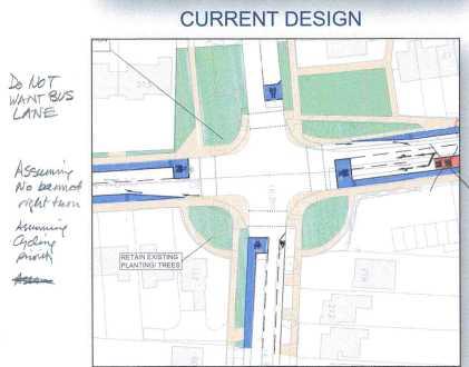
8 DESIGN OBJECTIVES & COMMITMENTS 8 City Deal commitment to provide (linked to City Deal Transport Strategy) 1. Increased bus reliability and improved journeys, leading to new services, increased frequency and reduced congestion 2. High-quality cycling infrastructure and pedestrian provision 3. High-quality design and public realm Further City Deal commitment to provide: No banned right turn into Warwick Road and no inclusion of floating bus stops on this corridor To develop two preferred design options, one including and one excluding banned turns for private vehicles at the Victoria Road junction Ensure that the preferred option developed includes details of proposed landscape areas and tree planting
9 9 WORKSHOPS 1A, 2A, 2B & 2B

10 LLF WORKSHOP OVERVIEW 10 Four Stakeholder Workshops (1A / 1B / 2A / 2B) were held with a wide representation of views Independently facilitated with presentations on design parameters and constraints Route split into southern & northern sections First two workshops focussed on highway cross sections, main junction designs and bus lanes Second two workshops focussed on minor side roads, bus stops and landscaping, drainage and street furniture Each table provided reporting on top 3 design ideas / design concerns along with other comments Workshop feedback is varied and should be read as a whole to obtain a view
11 11 WORKSHOPS 3 & 4
12 LLF WORKSHOP OVERVIEW 12 Two further workshops held Workshops 3 & 4 Workshop 3 - focussed on junctions of Victoria Rd and Gilbert Rd Workshop 4 - focussed on parking and off-route traffic management (rat running) Workshop feedback is varied and should be read as a whole to obtain a balanced view
13 13 FEEDBACK SUMMARY

14 9. Kings Hedges Junct 8. nr Hazelwood Cl 7. nr Carisbrooke Rd 6. Nr Gilbert Cl 5. Gilbert Road Junct 4. nr Windsor Rd 3. nr Rackham Cl 2. nr Victoria Road 1. Victoria Road Junct
15 KEY FEEDBACK THEMES CROSS SECTIONS 15 Southern Half: Suggestions for a symmetrical allocation of space on both sides of the road with cycle lanes on both sides of the road where possible; Northern Half: Suggestions for a segregated footway and cycleway separated from the carriageway by a green verge with trees on either side of the carriageway; Segregated footways and cycleways are preferred but shared use paths could be considered in close proximity to schools; None of the workshop groups supported the compulsory purchase of land on the edge of the carriageway; In general designs did not include a bus lane and instead chose to reallocate the space to verges of cycleways;

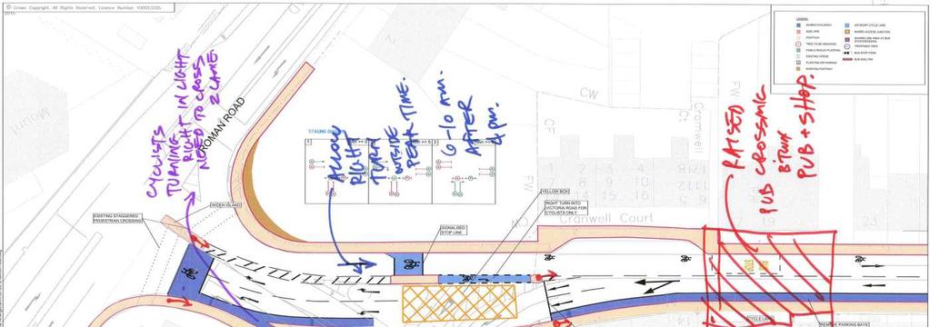
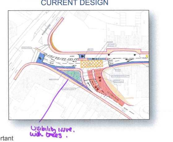
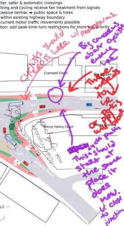
16 KEY FEEDBACK THEMES VICTORIA ROAD 16 Suggestion that any banned turns should occur only during peak times, if at all; Requests for better pedestrian and cyclist provision. With a key design factor being segregated cycle lanes for all movements and additional crossings ; Request that existing signal phasing and timings be relooked at to create additional capacity; Although the Do maximum generally scored higher than the Existing (3 out of 4 tables). All workshop groups preferred the HRARA (et al) alternative design overall in their scoring, with many preferring the fact it retained access to Victoria Road (no banned turns).


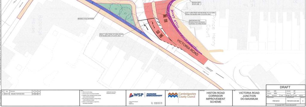
17 KEY FEEDBACK THEMES VICTORIA ROAD 17


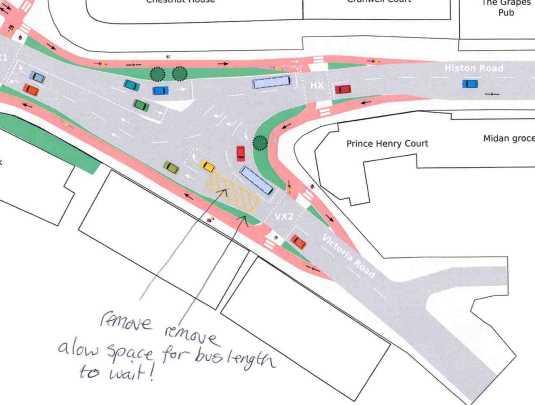
18 KEY FEEDBACK THEMES VICTORIA ROAD 18
 alternative option due to extensive pedestrian")
19 KEY FEEDBACK THEMES GILBERT ROAD JUNCTION 19 Request for a raised crossing at junction to serve school movements; General support for a Dutch Style Roundabout design with segregated ped and cycle movements in all directions; Request to retain/improve trees and verges where possible in the design; Two workshop groups preferred the HRARA (et al) alternative option due to extensive pedestrian and cycling provision. One workshop group preferred the Existing layout and one preferred the Do Maximum proposal.


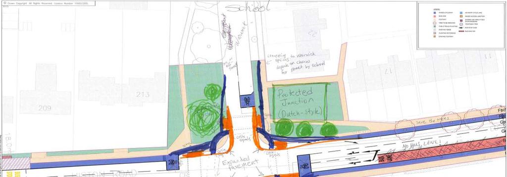
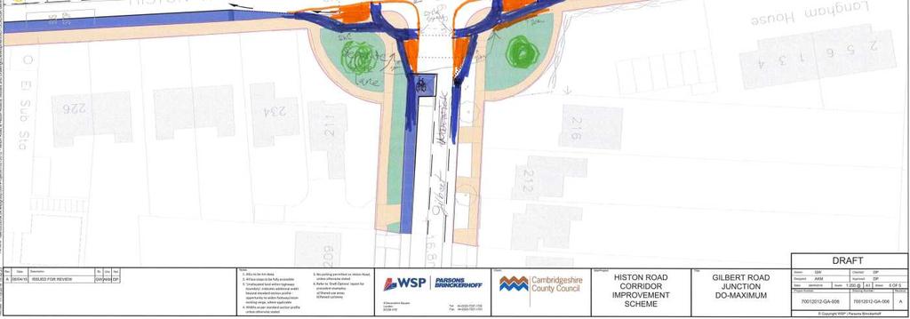
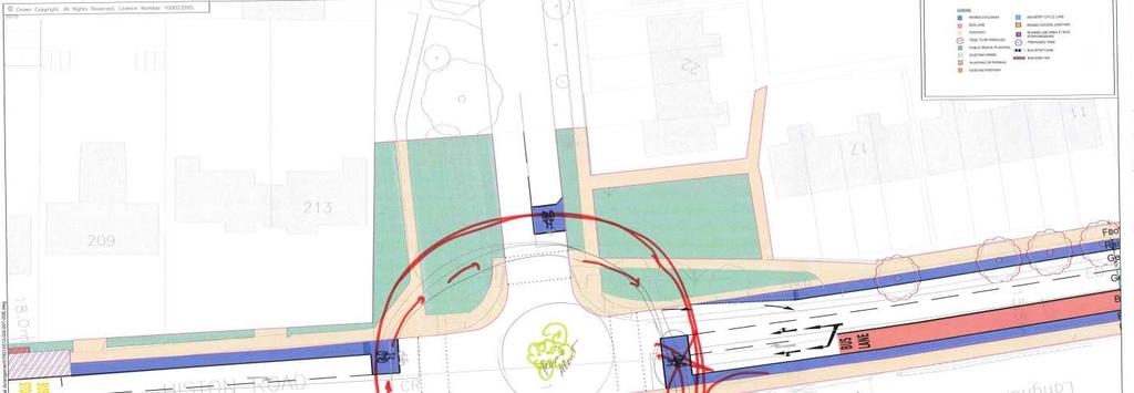
20 KEY FEEDBACK THEMES GILBERT ROAD 20


21 KEY FEEDBACK THEMES GILBERT ROAD 21

22 KEY FEEDBACK THEMES KINGS HEDGES JUNCTION 22 Request that express buses should routed through the NIAB /Darwin Green development and Huntingdon road to enable greater road space for ped/cycle; Request to reclaim more space for trees and verges;

23 KEY FEEDBACK THEMES KINGS HEDGES JUNCTION 23
24 KEY FEEDBACK THEMES MINOR ROAD CROSSINGS 24 Raised crossings with priority for pedestrians and cyclists were popular; Additional pedestrian and cyclist crossings are desired at a number of points along Histon Road to reduce distance between them; Specific crossings recommendations included just north of Victoria Road at Borrowdale (to link to the pedestrian and cyclist cut through) and at Carisbrooke;

25 KEY FEEDBACK THEMES BUS STOPS & LAYBYS 25 General acceptance there is no room for floating bus stops along Histon Road and were not desired by local residents of the Road; Where road space allows, bus laybys should be retained or included; Identified that provision would be need for school bus/coaches for St Luke s Primary School. Current layby needs to be retained for this purpose; Suggestion by some residents that not all current bus stops are needed along Histon Road as thought to not be well used (Southern End);

26 KEY FEEDBACK THEMES LANDSCAPING, DRAINAGE & STREET FURNITURE 26 Sustainable urban drainage (and improved surface water drainage in general) were welcome concepts and their integration sought after; Request that street furniture and landscaping that fits the historic nature of the street should be incorporated into the design; General acknowledgement there is less space on Histon road for landscaping so opportunities should be made where possible; Creative landscaping such as rain gardens should be considered;
 identified as: Benson Street / Canterbury Street area between Histon and Huntingdon Roads and Oxford Road to Windsor Road link")
27 KEY FEEDBACK THEMES MITIGATION IDEAS & CONCERNS (RAT RUNNING) 27 Concerns regarding knock on impacts of increased rat running routes and loss of parking for residents. Areas of concern relating to rat running are primarily (but not only) identified as: Benson Street / Canterbury Street area between Histon and Huntingdon Roads and Oxford Road to Windsor Road link between Histon and Huntingdon Roads. Akeman Street to Stretten Avenue. Desire for Benson Street / Canterbury Street area to become a home zone

28 KEY FEEDBACK THEMES MITIGATION IDEAS & CONCERNS (PARKING) 28 Residents in general do not wish to lose the on-road parking spaces on the south of Histon Road, due to concerns of displacement and effect on local business, carers etc Calls for revised parking strategies in the area e.g. pay and display, and throughout the city. A park and ride at the northern end of Histon Road and or Girton Interchange, is thought could potentially reduce the traffic using Histon Road as a radial route into the city. However there are difficulties in identifying a suitable site, land ownership etc and CCC has indicated a new P&R is unlikely to come forward at these locations. Support for revised modelling with the previously banned turns re-instated in order to inform future decision making.

29 GENERAL FEEDBACK THEMES 29 Preference for designs which incorporate segregated cycle/ped provision and separation from the road via green verges & trees; Preference for existing mature trees along corridor to be retained and additional trees to be added where there is room to do so on the Northern Section of the road; Generally, Do Maximum designs have scored higher than existing, but HRARA (et al) designs scored highest; Concerns of rat running should any scheme go ahead and further traffic modelling required to better understand impacts; Preference for no banned turns at junctions. Secondary compromise that any banned turns are only at peak times; Parking on Histon Road is felt should be retained. If displaced should be managed with a wider Residents Parking Scheme as an option. Request for revised parking surveys to inform further designs. Local residents do not see the road as just a strategic transport corridor ; In general residents do not support bus lanes on Histon Road even though bus priority is a key objective of the scheme for Histon Road
30 Histon Road Corridor Design Workshops Summary of all Feedback January 2017
MILTON ROAD LLF PROJECT UPDATE
 Greater Cambridge City Deal MILTON ROAD LLF PROJECT UPDATE 9 th May 2017 Project objectives Comprehensive priority for buses in both directions wherever practicable; Additional capacity for sustainable
HISTON ROAD Have your say on better public transport, cycling and walking journeys
 HISTON ROAD Have your say on better public transport, cycling and walking journeys Have your say: Please complete the survey inside this leaflet or online at www.greatercambridge.org.uk/histonconsultation
Milton Road Project Update. Paul van de Bulk 30 January 2018
 Milton Road Project Update Paul van de Bulk 30 January 2018 Milton Road Project Objectives Comprehensive priority for buses in both directions wherever practicable; Safer and more convenient routes for
The Greater Cambridge City Deal
 The Greater Cambridge City Deal Submission concerning the Histon Road initial consultation on better bus, cycling and walking trips. From: Carina O Reilly, Charlotte Perry and Mike Todd-Jones, City Councillors,
North West Non-Technical Summary of the Transport Assessment September 2011
 North West Non-Technical Summary of the Transport Assessment September 2011 Introduction This is a Non-Technical Summary of the findings of the Transport assessment work undertaken for the proposed North
Map 1 shows the two roads, and how they fit into the public transport network in and around Cambridge.
 Milton Road and Histon Road corridors bus priority infrastructure 1. Purpose The County Council would like to understand in more detail, the options to deliver the most effective corridor-based public
2 Junction: Histon Road / Huntingdon Road / Victoria Road / Castle Street / Mount Pleasant (HHVCM)
") 5th Apr 2017 Resolutions for the City Deal Assembly and Board from the Histon Road Local Liaison Forum Histon Road/B1049 is an important main B-road connecting Cambridge with outlying towns and villages.
5th Apr 2017 Resolutions for the City Deal Assembly and Board from the Histon Road Local Liaison Forum Histon Road/B1049 is an important main B-road connecting Cambridge with outlying towns and villages.
HISTON ROAD STAKEHOLDER WORKSHOP REPORT - (PART 1)
") REPORT N O 70012012-22 HISTON ROAD STAKEHOLDER WORKSHOP REPORT - (PART 1) THE GREATER CAMBRIDGE CITY DEAL JANUARY 2017 HISTON ROAD STAKEHOLDER WORKSHOP REPORT - (PART 1) THE GREATER CAMBRIDGE CITY DEAL
REPORT N O 70012012-22 HISTON ROAD STAKEHOLDER WORKSHOP REPORT - (PART 1) THE GREATER CAMBRIDGE CITY DEAL JANUARY 2017 HISTON ROAD STAKEHOLDER WORKSHOP REPORT - (PART 1) THE GREATER CAMBRIDGE CITY DEAL
Transport Workshop Dearbhla Lawson Head of Transport & Infrastructure Policy & Funding University of the Third Age.
 Transport Workshop Dearbhla Lawson Head of Transport & Infrastructure Policy & Funding University of the Third Age 30 th March 2015 1 Presentation Overview Roles and responsibilities Snapshot of Key Challenges
Greater Cambridge City Deal. Initial consultation on better bus, cycling and walking trips. Milton Road
 Greater Cambridge City Deal Initial consultation on better bus, cycling and walking trips Milton Road Response by Kings Hedges, East and West Chesterton Labour Parties The Greater Cambridge City Deal has
Milton Road Bus Stop and Crossings Workshop WSP. 19th September 2017
 Bus Stop and Crossings Workshop WSP 19th September 2017 Workshop Aims Task 1: Identify preferences for bus stop designs relative to: (a) Ranking preference between 4 possible bus stop designs on the narrower
Technical note. 1. Introduction
 Project: A428 study - Phase 2 To: Adrian Shepherd Subject: Park & Ride site locations From: Atkins Date: Jun 3, 2016 cc: Ashley Heller 1. Introduction 1.1. Purpose of Technical Note The purpose of this
March Maidstone Integrated Transport Strategy Boxley Parish Council Briefing Note. Context. Author: Parish Clerk 2 March 2016
 Context. Author: Parish Clerk 2 The Draft Integrated Transport Policy (DITS) sets out a vision and objectives, and identifies a detailed programme of interventions to support the Maidstone Borough Local
21.07 TRANSPORT CONNECTIVITY AND INFRASTRUCTURE
 21.07 TRANSPORT CONNECTIVITY AND INFRASTRUCTURE 21.07-1 Connectivity and Choice Transport connectivity and mode choice are critical to achieving productive, sustainable and socially just cities. Travel
Chelmsford City Growth Package
 Chelmsford City Growth Package Public Consultation Document Volume 2 West Chelmsford July - August 2017 Chelmsford City Growth Package Public Consultation Document - Volume 2 - West Chelmsford Contents
Developing a Birmingham Transport Space Allocation policy. David Harris Transport Policy Manager Economy Directorate Birmingham City Council
 Developing a Birmingham Transport Space Allocation policy David Harris Transport Policy Manager Economy Directorate Birmingham City Council Birmingham s Sustainable Urban Mobility Plan Birmingham Connected
MILTON ROAD ~ MITCHAM'S CORNER PARAMICS MODEL INITIAL OPTION TESTING
 MILTON ROAD ~ MITCHAM'S CORNER PARAMICS MODEL INITIAL OPTION TESTING NOVEMBER 216 MILTON ROAD ~ MITCHAM'S CORNER PARAMICS MODEL INITIAL OPTION TESTING Cambridgeshire County Council Type of document (version)
University of Victoria Campus Cycling Plan Terms of Reference. 1.0 Project Description
 University of Victoria Campus Cycling Plan Terms of Reference 1.0 Project Description The Campus Cycling Plan, a first for the University, will provide a comprehensive and coordinated approach to support
9. Parking Supporting Statement
 9. Parking Supporting Statement Content 1. Setting the Scene 2. Vision 3. Parking and the Shared Priorities 4. Issues 5. Delivery Programme in the first Plan Period 2001/02 2005/06 6. Good Practice 7.
CAMBOURNE TO CAMBRIDGE BETTER PUBLIC TRANSPORT PROJECT PHASE 2 PUBLIC CONSULTATION MADINGLEY MULCH ROUNDABOUT TO CAMBOURNE
 CAMBOURNE TO CAMBRIDGE BETTER PUBLIC TRANSPORT PROJECT PHASE 2 PUBLIC CONSULTATION MADINGLEY MULCH ROUNDABOUT TO CAMBOURNE Have your say on proposals for a new public transport link and Park & Ride facility
BELFAST RAPID TRANSIT. Ciarán de Búrca Director, Transport Projects Division Department for Regional Development
 BELFAST RAPID TRANSIT Ciarán de Búrca Director, Transport Projects Division Department for Regional Development Objectives of Belfast Rapid Transit To provide a modern, safe, efficient and high quality
High frequency bus services operating to Little Island; Creation of a new Park and Ride site and train station at North Esk;
 Cork County Council 7 th December 2018 Dear Adrian O Neill (aoneill@jbbarry.ie) The Transport and Mobility Forum, Cork (TMF) is a representative group of organisations who have a common interest in sustainable
CUERDEN TRANSPORT PROPOSALS
 1 CUERDEN TRANSPORT PROPOSALS The transport assessment, submitted with the Cuerden development planning application, looks at access to the site and the impact on the local road network in detail. This
Nottingham Cycle City Frequently Asked Questions
 Nottingham Cycle City Frequently Asked Questions About the scheme How much money is to be spent on cycling? And where is the money from? We have 6.1 million in Growth Fund which we will be investing directly
The minutes of the meeting held on Tuesday 13th June 2017 were agreed as a correct record. There were no matters arising.
 MILTON ROAD LOCAL LIAISON FORUM: MINUTES Date: Tuesday 12th September 2017 Time: 18.00-20:00 Place: Present: Apologies: Chesterton Community College, Rex Freeman Hall LLF Members County Councillor Jocelynne
A127/A130 Fairglen Interchange Improvement Schemes. Information Leaflet February 2017
 A127/A130 Fairglen Interchange Improvement Schemes Information Leaflet February 2017 1 2 Foreword By Councillor Kevin Bentley Essex is continuing to grow as a vibrant economic hub and as a fantastic place
TRANSPORT AND MOVEMENT
 TRANSPORT AND MOVEMENT Movement Strategy Public Transport Cycling and Walking Road Network Parking Standards Transport Impact Assessments Traffic Management Policies DRAFT POOLBEG PLANNING SCHEME Movement
Berwick Health and Education Precinct: Casey Amendment C207 (Part 1) Submission to Planning Panels Victoria
 Submission to Planning Panels Victoria") Berwick Health and Education Precinct: Casey Amendment C207 (Part 1) Submission to Planning Panels Victoria August 2018 CONTENTS 1 Executive summary... 1 2 Summary of the amendment... 2 3 Submission...
Berwick Health and Education Precinct: Casey Amendment C207 (Part 1) Submission to Planning Panels Victoria August 2018 CONTENTS 1 Executive summary... 1 2 Summary of the amendment... 2 3 Submission...
To: The results of these surveys have been analysed and are summarised within this Technical Note.
 Technical Note Project: Histon Road / Milton Road, Cambridge Parking Surveys To: Andy Harrison Subject: Survey Report v1.6 From: Jonathan Barlow Date: 18 th February 2016 cc: Richard Jones / Dave Boddy
Cambridge Access and Capacity Study
 Report To: Greater Cambridge City Deal Executive Board 9 June 2016 Lead Officer: Graham Hughes, Executive Director, Economy and Environment, Cambridgeshire County Council Cambridge Access and Capacity
North Coast Corridor:
 North Coast Corridor: Connecting People, Transportation & Environment Legislative Hearing: 11.8.10 1 North Coast Corridor Region s Lifeline A Regional Strategy Mobility, Economy & Environment North Coast
IAN WHITE ASSOCIATES. Crawley Station Gateway Public Realm
 IAN WHITE ASSOCIATES Crawley Station Gateway Public Realm contents 1. objectives & client brief 2. site appraisal 3. best practice guidance 4. design concept 1. objectives & client brief Crawley Train
The Cabinet Member for Highways & Streetscene. Aurang Zeb - Head of Highways & Transport
 LONDON BOROUGH OF RICHMOND UPON THAMES Cabinet Member Decision DATE: January 2012 REPORT OF: LEAD OFFICER: SUBJECT: WARDS: The Cabinet Member for Highways & Streetscene Aurang Zeb - Head of Highways &
TS 109 DURHAM ROAD QTC PHASE 4 PROJECT PROPOSAL. Page 1
 TS 109 DURHAM ROAD QTC PHASE 4 PROJECT PROPOSAL Page 1 Table of Contents 1.0 Introduction... 3 2.0 Project Overview... 3 3.0 Project Proposals... 4 3.1 Enfield Road / Durham Road Junction... 3 5 3.2 Summerfield
E4 Cycle Route Exeter University to Redhayes Bridge. - Recommendations from Exeter Cycling Campaign
 E4 Cycle Route Exeter University to Redhayes Bridge - Recommendations from Exeter Cycling Campaign 1.0 Introduction Exeter Cycling Campaign has prepared this report to provide recommendations for Devon
DESIGN CODE. Enterprise West Harlow London Road North Design Code 21
 DESIGN CODE Enterprise West Essex @ Harlow London Road North Design Code 21 4 MAXIMUM BUILDING HEIGHTS 4.1 Table 4A sets out maximum building height standards for each character area within the LDO boundary.
Lea Bridge Road A street for everyone Tell us
 Lea Bridge Road A street for everyone Tell us Public consultation document Section H your views 1 Lea Bridge Road: a street for everyone Introduction Mni-Holland is an exciting programme to improve walking
Living Streets response to the Draft London Plan
 Living Streets response to the Draft London Plan Contents Living Streets response to the Draft London Plan... 1 About Living Streets... 2 Summary... 2 Consultation response... 3 Chapter 1: Planning London
A1307 Haverhill to Cambridge: Approval to consult on transport improvement concepts
 Report To: Greater Cambridge City Deal Executive Board 3 March 2016 Lead Officer: Graham Hughes, Executive Director of Economy, Transport and Environment, Cambridgeshire County Council A1307 Haverhill
Introduction. Prince Street Cycling Ambition Fund Public Realm Project
 Introduction The (CAF) project will create a high quality, 8-80 s cycle route up the west side of Prince Street from Cumberland Road, over Prince Street bridge to the Centre. This is part of the City Centre
SCHEME DESIGN AND ENGINEERING
 THE NORTH SOMERSET COUNCIL (SOUTH BRISTOL LINK CLASSIFIED ROAD) SIDE ROADS ORDER 2013 THE NORTH SOMERSET COUNCIL (SOUTH BRISTOL LINK) COMPULSORY PURCHASE ORDER 2013 THE NORTH SOMERSET COUNCIL (SOUTH BRISTOL
Regional Bus Priority
 Regional Bus Priority Recommendation(s) That the Board: i) Notes the systematic review for bus priority measures on the proposed Frequent Transit Network (FTN). Executive summary The New Network public
Appendix 12 Parking on footways and verges
 Appendix 12 Parking on footways and verges Legal position Parking on footways and verges whether wholly or partly is banned throughout London, unless signs are placed to allow parking. The ban requires
122 Avenue: 107 Street to Fort Road
 : 107 Street to Fort Road November 24, 2015 4:30 8:00 p.m. Meeting Purpose Summarize project work completed to date Share results of public input from Phase 1 Share the draft concept plan and proposed
2. Context. Existing framework. The context. The challenge. Transport Strategy
 Transport Strategy Providing quality connections Contents 1. Introduction 2. Context 3. Long-term direction 4. Three-year priorities 5. Strategy tree Wellington City Council July 2006 1. Introduction Wellington
SLOUGH Stage 3 Road Safety Audit of A4 London Road, M4 J5 to Sutton Lane
 SLOUGH Stage 3 Road Safety Audit of A4 London Road, M4 J5 to Sutton Lane Exception Report Client Officer Rudo Beremauro Date 20 January 2015 RSA /Project Sponsor s Contents Section 3 Project Sponsor's
Comments on the Hailsham to Eastbourne Sustainable Transport Corridor
 Comments on the Hailsham to Eastbourne Sustainable Transport Corridor Version 1.1 25/01/2015 Paul Humphreys 1 Table of Contents Version Control... 2 Summary... 2 Rationale provided by ESCC... 3 The ESCC
IMPACT OF THE BERMUDA CONNECTIVITY PROJECT ON CYCLING
 IMPACT OF THE BERMUDA CONNECTIVITY PROJECT ON CYCLING BBAG BRIEFING NOTE EMAIL: BERMUDABRIDGEAGP@BTINTERNET.COM WWW.FACEBOOK.COM/GROUPS/BERMUDABRIDGEAG TWITTER @BERMUDABRIDGEAG CYCLING BBAG BRIEFING NOTE
WELCOME. Purpose of the Open House. Update you on the project. Present a draft recommended plan. Receive your input
 WELCOME Purpose of the Open House The Town of Smiths Falls has initiated the Beckwith Street Redevelopment Plan that includes the preparation of a streetscape functional design for the renewal of Beckwith
Oxfordshire Local Transport Plan 4 Science Vale Cycle Network Project Proposal Didcot Ladygrove Link
 Overview of project: The Ladygrove Link will provide a modern, direct, off-road, active travel route from the new Didcot North East development and new leisure centre to the strategic Cow Lane Tunnel.
Moving Cambridge. City of Cambridge Transportation Master Plan Public Consultation Centre. March 7, :00 8:00 PM.
 City of Cambridge Transportation Master Plan Public Consultation Centre March 7, 2018 5:00 8:00 PM Region of Waterloo City of Cambridge Transportation Master Plan Public Consultation Centre March 7, 2018
MARKHOUSE ROAD IMPROVEMENTS
 MARKHOUSE ROAD IMPROVEMENTS www.enjoywalthamforest.co.uk Waltham Forest is changing and we want you to be part of it. Thanks to a funding pot of 27million from Transport for London, we re delivering the
Bristol City Council has produced a draft Bristol Transport Strategy document.
 Bristol Transport Strategy Summary Document Introduction Bristol City Council has produced a draft Bristol Transport Strategy document. The Strategy fills a gap in transport policy for Bristol. We have
London Cycle Network Annual Report 2000
 London Cycle Network Annual Report 2000 A cycle network for London by 2005 A cycle network for London by 2005 The London Cycle Network will: provide local links between residential neighbourhoods, railway
LEA BRIDGE ROAD - A STREET FOR EVERYONE Public consultation document
 LEA BRIDGE ROAD - A STREET FOR EVERYONE Public consultation document TELL US Bakers Arms to Leyton Green Road (Section D, E, F) Leyton Green Road to Whipps Cross Roundabout (Section G) YOUR VIEWS www.enjoywalthamforest.co.uk
A65 TRANSPORT ASSESSMENT. 13 th May 2005
 A65 TRANSPORT ASSESSMENT 13 th May 2005 1 CONTENTS 1.0 Introduction 2.0 Overview 3.0 Detailed Assessment of the A65 Corridor 4.0 Future Proposals 5.0 Conclusions List of Figures Figure 1: AM Average Traffic
Phone: Ref No: 06/2018/0884
 Development Directorate Preston City Council Town Hall Lancaster Road Preston PR1 2RL FAO Ben Sandover Phone: 01772 533855 Email: david.allen@lancashire.gov.uk Ref No: 06/2018/0884 Date: 20 September 2018
How do we design for pedestrians? Case study: transforming the Walworth Road
 How do we design for pedestrians? Case study: transforming the Walworth Road David Moores, Director of Public Realm Institution of Highways and Transportation, November 2009 Presentation overview Design
DMURS - Practical Implications
 Comhairle Contae Fhine Gall DMURS - Practical Implications Sean McGrath. 13 November 2013 Planning and Strategic Infrastructure Department DMURS Practical Implications What DMURS means for: Street Layouts
ENFIELD TOWN THE REVISED DESIGN
 TOWN THE REVISED DESIGN We re turning Enfield into a borough that encourages walking and cycling, a place that s easy for all of us to get around however we choose to travel. A greener place, with safer
The Wincheap Society
 The Wincheap Society s on sections of: Thanington 4th Arm Slip Road, Walking, Cycling & Horse-Riding Assessment & Review Report, by Peter Brett Associates, October 2017, on behalf of Pentland Properties
Frascati Road and Temple Hill Route Improvements. Outline Design Report to Accompany Public consultation
 Frascati Road and Temple Hill Route Improvements Outline Design Report to Accompany Public consultation September 2013 Background: Dún Laoghaire-Rathdown is committed to providing high quality pedestrian
MILTON ROAD CONSULTATION REPORT THE GREATER CAMBRIDGE CITY DEAL
 MILTON ROAD CONSULTATION REPORT THE GREATER CAMBRIDGE CITY DEAL MAY 2016 MILTON ROAD CONSULTATION REPORT THE GREATER CAMBRIDGE CITY DEAL Cambridgeshire County Council Consultation Report Project no: 70012012
APPENDIX B: CAMBRIDGE NORTH WEST TRANSPORT STUDY
 APPENDIX B: CAMBRIDGE NORTH WEST TRANSPORT STUDY Appendices not included due to size Whole report including appendices can be found here: http://www.cambridgeshire.gov.uk/transport/strategies/longterm/developmenta
Easton Safer Streets - Final Project Report BRISTOL
 - Final Project Report BRISTOL A Sustrans Community Street Design Project in partnership with Bristol City Council February 07 About Sustrans Sustrans makes smarter travel choices possible, desirable and
Have your say on the transformation of Oxford Street West
 Have your say on the transformation of Oxford Street West About Living Streets We are Living Streets, the UK charity for everyday walking. We want to create a walking nation, free from congested roads
National Transport Awards Cambridge Park & Ride
 National Transport Awards Cambridge Park & Ride What Cambridgeshire has achieved q An award winning scheme focussed on quality. q Four sites, with a fifth site due to be built later this year. q 950,000
A1307 HAVERHILL TO CAMBRIDGE
 REPORT N O 70012014 A1307 HAVERHILL TO CAMBRIDGE PREFERRED OPTIONS REPORT EXECUTIVE SUMMARY PUBLIC FEBRUARY 2017 A1307 HAVERHILL TO CAMBRIDGE Cambridgeshire County Council Type of document (Version 6.0)
Principles. 4biii. Good Urban Design
 Principles Good Urban Design The Sherford approach to the hierarchy of travel modes is fostered and encouraged by a combination of influences. These are as follows, described in further detail below: Town
Douglas Land Use and Transportation Strategy (DLUTS) Summary. August 2013
 Summary. August 2013") Douglas Land Use and Transportation Strategy (DLUTS) Summary August 2013 Background Douglas is a large and popular residential suburb of approximately 30,000 persons on the periphery of Cork City along
Douglas Land Use and Transportation Strategy (DLUTS) Summary August 2013 Background Douglas is a large and popular residential suburb of approximately 30,000 persons on the periphery of Cork City along
Consultation Report & Results August 2016
 Queen Edith s Way Consultation Report & Results August 216 Summary The consultation on walking and cycling improvements along Queen Edith s Way took place from 2 June to 1 August 216. A total of 64 survey
Your views are important. Please fill in a form before you leave. Or alternatively
 Drum Property Group is delighted to welcome you to this exhibition which sets out our initial proposals for a mixed-use development at Stead s Place, Edinburgh. We are keen to hear the views of local people
The existing site constraints which may be encountered for the A428 scheme proposals are divided into sections as follows.
 Project: A428 Study To: Cambridgeshire County Council Subject: Tidal Bus lane Review From: Atkins Date: 24 May 2016 cc: Introduction As part of the A428 Corridor Study to improve the bus journey time between
RAA Submission to: The City of Adelaide Draft Integrated Movement Strategy Moving Adelaide
 RAA Submission to: The City of Adelaide Draft Integrated Movement Strategy 2012-22 Moving Adelaide May 2012 RAA Submission to the City of Adelaide Draft Integrated Movement Strategy 2012-22 Moving Adelaide
A52. Nottingham Junctions. Construction at Nottingham Road and Cropwell Road junctions commencing early January 2017
 Nottingham Junctions Construction at Nottingham Road and Cropwell Road junctions commencing early January 2017 Introduction The is the key east-west link across the East Midlands. The route is subject
Public Consultation on Braintree Integrated Transport Package (ITP) HAVE YOUR. Consultation open from 24 September to 5 November 2018 SAY
 HAVE YOUR. Consultation open from 24 September to 5 November 2018 SAY") Public Consultation on Braintree Integrated Transport Package (ITP) HAVE YOUR SAY Consultation open from 24 September to 5 November 2018 Contents Introduction 3 Background 4 Springwood Drive Roundabout
Public Consultation on Braintree Integrated Transport Package (ITP) HAVE YOUR SAY Consultation open from 24 September to 5 November 2018 Contents Introduction 3 Background 4 Springwood Drive Roundabout
CAMBOURNE TO CAMBRIDGE Better Bus Journeys: Phase One
 CAMBOURNE TO CAMBRIDGE Better Bus Journeys: Phase One Have your say on Improved, faster and more reliable bus services between a new Park & Ride site and Cambridge Two options for a new Park & Ride site
CAMBRIDGE SOUTH WEST PARK & RIDE
 CAMBRIDGE SOUTH WEST PARK & RIDE Have your say on: Extra Park & Ride spaces to the south west of Cambridge Bus priority measures into the city centre CREATING MORE PARK & RIDE SPACES The existing Park
Submission Cover Sheet Mordialloc Bypass Project EES IAC
 Submission Cover Sheet Mordialloc Bypass Project EES IAC 61 Request to be heard?: yes Full Name: Organisation: Affected property: Attachment 1: Attachment 2: Attachment 3: Comments: Lucinda Bertram Aspendale
Public Event 1 Community Workshops
 Public Event 1 Community Workshops Nov. 24 & Dec. 3, 2016 Welcome Workshop Purpose We re looking to you for ideas and insights to help guide future transportation infrastructure planning in the Park Lawn
Urban Street Design and Development
 Urban Street Design and Development Ashok Bhattacharjee, Advisor, Clean Air and Sustainable Mobility, Centre for Science and Environment CSE Workshop on Safe Access and Parking - Lytton Hotel, Kolkata
M6 Junction 10 Public Consultation
 M6 Junction 10 Public Consultation December 2015 Introduction Walsall Council and Highways England are developing plans to provide a long term improvement to M6 junction 10. We are holding this non-statutory
Green Streets and Urban Greenways
 127 11 Green Streets and Urban Greenways 11. Green Streets and Urban Greenways 128 11 Green Streets and Urban Greenways Once the traffic-free section of a route has come to an end, then comes the remaining
CSRM Modelling Summary Report for Cambridge and South Cambridgeshire Local Plans July 2013
 CSRM Modelling Summary Report for Cambridge and South Cambridgeshire Local Plans July 2013 Prepared by WSP Group and Atkins EXECUTIVE SUMMARY This Summary Report outlines the work undertaken by WSP Group
WELCOME TO OPEN HOUSE # 1 June 14, 2017
 Langstaff Road Weston Road to Highway 7 Class Environmental Assessment Study WELCOME TO OPEN HOUSE # 1 June 14, 2017 Please sign in and join our mailing list Purpose of Open House #1 & Study Area York
RESPONSIVE ROUNDABOUTS MYTH OR REALITY
 RESPONSIVE ROUNDABOUTS MYTH OR REALITY Andy Poole WSP UK Three White Rose Office Park Millshaw Park Lane Leeds LS11 0DL andy.poole@wspgroup.com Keywords: Traffic signals, optimisation, micro-simulation,
Guildford Borough (Draft)
") ITEM Annex Page 7 Guildford Borough (Draft) Forward Programme Part A This is a work in progress and its completion is subject to the adoption of the Local Plan and Infrastructure Delivery Schedule November
ITEM Annex Page 7 Guildford Borough (Draft) Forward Programme Part A This is a work in progress and its completion is subject to the adoption of the Local Plan and Infrastructure Delivery Schedule November
Cambourne to Cambridge Public Transport Route. 14 November 2018
 Cambourne to Cambridge Public Transport Route 14 November 2018 Key City Deal Commitment 10-15% reduction in vehicles from 2011 figure Equivalent to a 24% reduction today Continued growth increases the
Ormond & McKinnon Walks Response to Draft Glen Eira Community Plan
 Response to Draft Glen Eira Community Plan We would like to take this opportunity to thank Glen Eira City Council for the opportunity to comment on the Glen Eira Draft Community Plan. Below is an outline
MANNERS/DIXON/VICTORIA/WlLLlS STREETS TRAFFIC AND STREETSCAPE IMPROVEMENTS
 I! ATTACHMENT 3 TO REPORT 03.481 PAGE 1 OF 13 CITY INFRASTRUCTURE COMMllTEE 6 AUGUST 2003 MANNERS/DIXON/VICTORIA/WlLLlS STREETS TRAFFIC AND STREETSCAPE IMPROVEMENTS REPORT 4 (I 215/48/IM) 1. Purpose of
1.2. South Cambridgeshire Local Plan Proposed Submission, July 2013
 Project: A428 Corridor Study To: Subject: Planning Policy Context From: Date: 2 May 2014 cc: 1. Introduction The aim of this note is to provide a brief overview of the national and local policy relating
Initial ideas for bus and cycle links
 Initial ideas for bus and cycle links HAVE YOUR SAY The Greater Cambridge City Deal working in partnership: Please complete the survey inside this leaflet or online at: www.gccitydeal.co.uk/a1307 by 1
Warfield Neighbourhood Plan: 4.4 Infrastructure
 Warfield Neighbourhood Plan: 4.4 Infrastructure Previously decided Policy headings: Policy WNP16 Transport Impact of Development Policy WNP17 Transport Proposals Policy WNP18 New School Buildings Policy
A1307 HAVERHILL TO CAMBRIDGE CORRIDOR
 REPORT N O 70012014-003 A1307 HAVERHILL TO CAMBRIDGE CORRIDOR DRAFT CONCEPTS REPORT PUBLIC JANUARY 2016 A1307 HAVERHILL TO CAMBRIDGE CORRIDOR DRAFT CONCEPTS REPORT Cambridgeshire County Council Public
City of Hamilton s Transportation Master Plan (TMP) Public Consultation 3 December 2015
 Public Consultation 3 December 2015") City of Hamilton s Transportation Master Plan (TMP) Public Consultation 3 December 2015 McPhail Transportation Planning Services Ltd. AGENDA 6:00 7:00 pm Viewing Boards / Q & A with the Team 7:00 7:50
City of Hamilton s Transportation Master Plan (TMP) Public Consultation 3 December 2015 McPhail Transportation Planning Services Ltd. AGENDA 6:00 7:00 pm Viewing Boards / Q & A with the Team 7:00 7:50
Dún Laoghaire Rathdown County Council. Luas to Dart via UCD Cycle and Pedestrian Route
 Dún Laoghaire Rathdown County Council Luas to Dart via UCD Cycle and Pedestrian Route October 2012 Luas to Dart via UCD Cycle and Pedestrian Route DOCUMENT CONTROL SHEET Client: Project Title: Document
1.5 On this basis it is fundamental that the Transport Strategy for the site focuses on the following key criteria,
 1.0 Introduction 1.1 The Transport Assessment has been prepared on behalf of Eon and Roger Bullivant Ltd in respect of the proposed mixed use sustainable urban extension of Drakelow Park. 1.2 The methodology
Cycle traffic and the Strategic Road Network. Sandra Brown, Team Leader, Safer Roads- Design
 Cycle traffic and the Strategic Road Network Sandra Brown, Team Leader, Safer Roads- Design Highways England A Government owned Strategic Highways Company Department for Transport Road Investment Strategy
M25 junction 28 improvement scheme. Have your say
 M25 junction 28 improvement scheme Have your say 14 November 2016 6 January 2017 M25 junction 28 improvement scheme Have your say About us IMAGE Highways England is the government company charged with
Transportation Assessment
 Transportation Assessment Midtown Open House February 10, 2018 Overview Midtown in Focus Overview & Purpose of Today Transportation Assessment overview Summary of Transportation work to date Review & Analysis