Minutes: A motion was made to approve minutes from both the July and August BPAC meetings. That motion was approved.
|
|
|
- Justina Banks
- 5 years ago
- Views:
Transcription
1 Oakland BPAC 9/20/12 Attendees: Ann Killebrew, Carol Levine, Chris Hwang, Chris Kidd, Dave Campbell, Jason Patton, Jennifer Stanley, Liza Pratt, Midori Tabata, Robert Prinz, Ryan Chan, Tom Willging, Ade Oluwasogo, Wladimir Wlassowsky, Dan Tischler Minutes: A motion was made to approve minutes from both the July and August BPAC meetings. That motion was approved. Shattuck Avenue at 52 nd Street Wladimir Wlassowsky and Ade Oluwasogo from Public Works gave a presentation on a re-striping project for the intersection of Shattuck Avenue at 52 nd Street. A new striping plan had been applied for southbound traffic on Shattuck Avenue, creating a left/through travel lane and a right/through travel lane. On the southern side of the intersection, these two travel lanes merged back to one lane. This striping plan has created conflicts with bicyclists, not only with southbound drivers turning right at the intersection, but also with southbound drivers past the intersection where the two lanes merge. Public Works proposes a new striping plan that would make the right lane on Shattuck Avenue a Right-Turn-Only lane, with a bike lane between that lane and the left/through lane. The merge on the southern side of the intersection would be removed. This would place bicyclists to the left of rightturning drivers and remove the conflict in the merge area. The bike lane would exist only for the southbound approach to the intersection. When Shattuck Avenue is repaved and striped with bike lanes in 2013, it would connect to this small bike lane piece. Comments: Dave Campbell expressed a desire to return the intersection to it's original configuration, with one lane of travel in each direction and no dedicated turning lanes. This would resolve the pinch point experienced by northbound bicyclists when they cross the intersection. Dave asked for the Right-of-Way for the street, which was given as 46 feet. The dedicated right-turn lane is 12 feet, the bike lane is 5 feet, the through/left lane is 11 feet, and the northbound travel lane & parking lane are a combined 18 feet. Dave asked that either the original configuration be brought back or parking removed to resolve the pinch point issue for northbound bicyclists. Staff noted that removing street parking on the north side of the intersection would be controversial with the residents of the adjacent apartment buildings. Dave asked that the City, in the future, be mindful of similar pinch points being created when a leftturn pocket is added to an intersection that has insufficient road width to accommodate both bicyclists and drivers side-by-side. The attendees were generally positive about removing the merge on the southern side of the intersection, and asked for staff to study shifting the street's center line to create more room for a northbound travel lane that could accommodate both bicyclists and drivers. Attendees asked about how the future bike lanes would transition into the planned bike lane, left of the dedicate right-turn lane. Attendees asked that the merging area for drivers moving over to the right-turn lane be highlighted with dashed lines, green paints, or other features. Staff responded that they preferred not to provide dashed striping when a bike lane moves diagonally across a roadway to position left of a right-turn lane, reasoning that bicyclists would be less likely to shoulder-check for overtaking traffic behind them if dashed lines were provided. Staff prefers dashed lines only when the bike lane keeps its position and right-turn pocket opens to the right of the straight bike lane.
2 Staff was open to providing yield signage where the bike lane merged, and expressed a willingness to examine the appropriateness of green-backed sharrows. Attendees asked staff whether it might be better to remove the bike lane from the proposed draft altogether to mitigate the pinch point for northbound bicyclists. Staff responded that the right-turn movements from southbound drivers presented the largest safety challenge, and thus wanted to retain the bike lanes. Staff also believed a pinch would take place for northbound bicyclists regardless of whether the southbound bike lane existed or not. Attendees asked staff to reduce the width of the right-turn lane in order to increase the size of the bike lane. Staff responded that they had already reduced the turn lane to 12 feet from the city standard of 14 feet. Bike Master Plan Reaffirmation Staff provided information on the reaffirmation of the city's bicycle master plan, which goes to City Council in December A Bicycle Master Plan must be either created, or reaffirmed, every 5 years in order for a city to maintain eligibility for the Caltrans Bicycle Transportation Account (BTA). Oakland adopted a Bicycle Master Plan in 2007, and needs to reaffirm the plan before the end of the year to retain BTA eligibility. Staff had planned to bring the Bicycle Master Plan to City Council earlier this year for reaffirmation, but instead decided to prepare a report to accompany the reaffirmation, outlining staff's priorities for future bike plan implementation. Staff feels that it is appropriate to reaffirm the existing bike plan rather than create a new one because it allows staff to take advatange of on-street opportunities rather than re-draft a new plan. Staff is asking for comments on this report before the end of the month in order for those comments to be fully incorporated before submittal to City Council. The staff report is meant to outline 5 goals/priorities for the future. 1. Maintain BTA eligibility 2. Put road diet projects in front of City Council as priority projects (road diets, by city ordinance, require City Council approval to move forward). This also includes adjusting the priorities of the bike plan, which values gap closure. As the bike network is filled out, different potential projects gain importance in their ability to close gaps to newly installed facilities. 3. Identify publicly, and communicate to council, the barriers that currently exist to the successful implementation of the bike plan. 4. Prepare the City for its next Bicycle Friendly Communities application staff wants the City to aim for Silver certification (Oakland currently is Bronze). Staff also hopes to update their priority projects and bundle together potential road-diet projects for study and SEIR purposes. The key road-diet projects identified by the City are: th Street Brush to Oak 2. East 12 th Street - 40 th Ave to 44 th Ave 3. Foothill Boulevard - 14 th Ave to 23 rd Ave 4. West MacArthur Boulevard Telegraph Ave to MLK Jr Blvd 5. Park Boulevard E 18 th Street to Excelsior Ave 6. Telegraph Avenue Aileen to 20 th St Staff is hoping to reaffirm the bike plan until at least , when they would begin the process of developing a new bike plan staff mentioned that some ACTC issues would determine when a new bike plan process was undertaken. Staff said that they would adjust their planning for priority projects depending upon the signing or veto of AB 2245 a bill that would provide CEQA exemption to bike lane projects. Staff said that, if AB
3 2245 passes, traffic studies for bike lanes would not be required to look at 30 year traffic volume projections, though they might look at them for reference purposes. Staff listed certain existing barriers to bike plan implementation: 1. CEQA/LOS forecasting requirements 2. Pavement quality on designated bikeways 3. Limitations of providing adequate bike parking on the sidewalk and conflicts with removing car parking for on-street bicycle parking 4. Creating a city-led procedure for introducing and implementing traffic calming on bicycle boulevards traffic calming is currently complaint-driven. 5. Increasing education and enforcement elements in creating a more bike-friendly city Staff wants to enlist the public's help in a campaign for a Silver Bicycle Friendly City designation. Attendees suggested getting bike shops and bike clubs involved in getting the word out. There was enthusiasm for a BPAC work session on creating a strong campaign. Pavement Report Midori and Carol gave a synopsis of their notes from a Public Works meeting on pavement quality and repair (document attached). The City has $6 million each year to spend on pavement repair, the average yearly need is $28 million, meaning the City is falling further behind each year. The City is on an 85 year pavement schedule to replace pavement on each street; cities typically should have a 30 year repavement cycle. 80% of the paving funds goes to upkeep of existing streets, 20% goes to whole-sale reconstruction. City Council can direct where and when streets get repaved. The City has a 1200 pothole backlog, and asks citizens to use the SeeClickFix app to report potholes, as it gives them a specific GPS location for the pothole. The City is experimenting with spot repairs, major repavings, and paving only travel lanes while leaving parking lanes in their current condition. 14 th Street Plans Staff asked for attendee direction on which configurations to study for bike infrastructure on 14 th Street. The project extends from West Oakland to Lake Merritt, through downtown. The extents are from Brush in the west to Oak in the east. The segment is approximately one mile long. The facility would connect to existing bike lanes on 14 th Street in West Oakland. 14 th Street has a highly variable width in this segment, with street parking permitted for most of its length. A 54 foot right-of-way is the predominant width, mostly in the eastern half of the segment. AC Transit is considering consolidation of lines that would move all bus traffic off of 14 th Street. 6 options were presented to attendees, 2 keeping the current configuration, 2 with a 4-to-3 road diet, and 2 with a 4-to-2 road diet. The options included sharrows, green-lane sharrows, bike lanes, and buffered bike lanes. 1-A 4 lanes of travel with sharrows 2-A 4 lanes of travel with green-lane sharrows 1-B 2 wide lanes of travel, a center turn lane, and sharrows 2-B 2 narrow lanes of travel, a center turn lane, and narrow bike lanes 3-A 2 wide lanes of travel and wide bike lanes 3-B 2 wide lanes of travel and buffered bike lanes The City bike plan calls for option 2-A on 14 th Street, but that is a model that staff now prefers not to use, considering them an ineffective facility. Attendees were least enamored of 2-A and 2-B. Staff were reticent to support 3-A or 3-B, as they are considered to be very politically difficult to achieve. Staff voiced their preference for option 1-B.
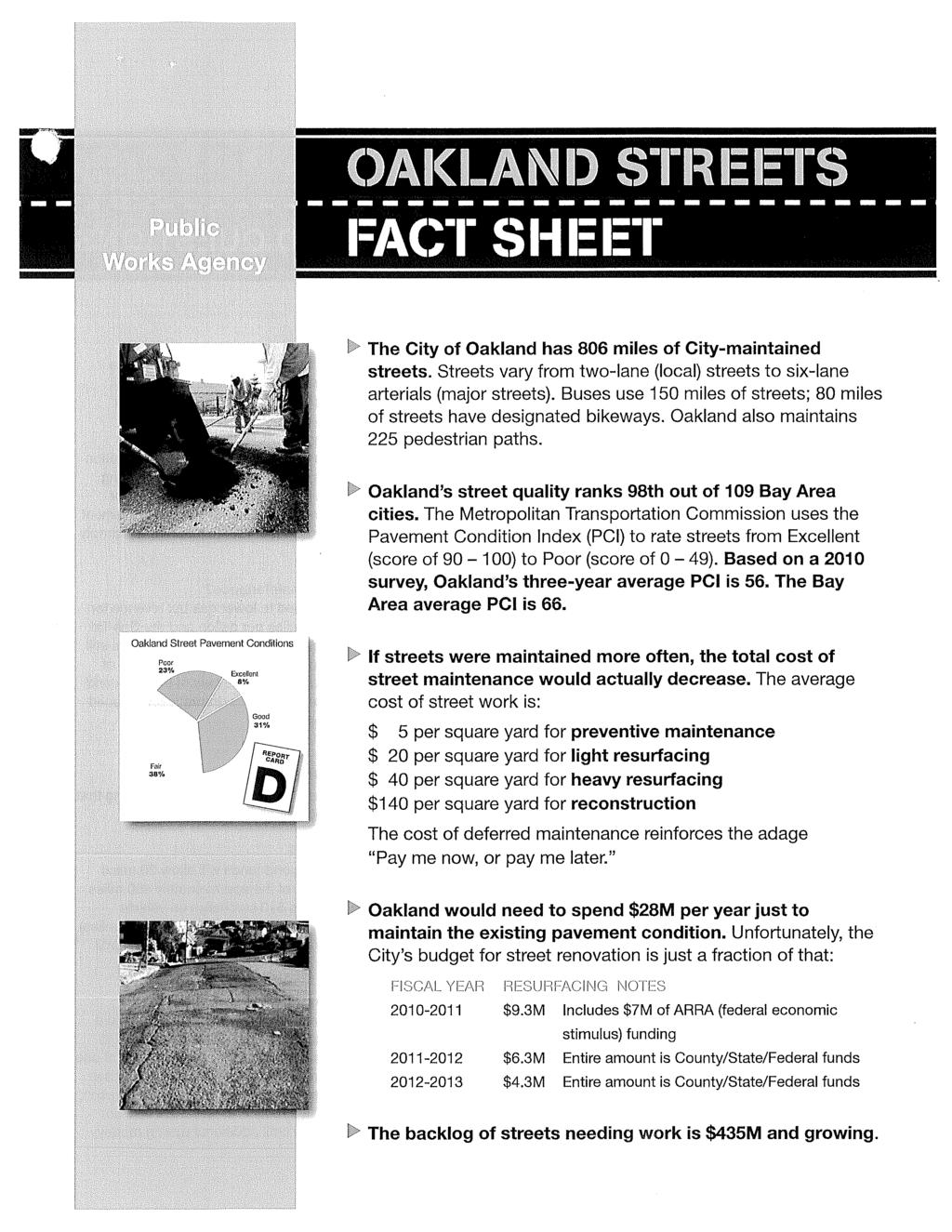
4 Staff and some attendees were concerned about the conflicts a 4-to-2 road diet would create for leftturning vehicles, especially since many cross streets are one-way. Some attendees worried about conflicts created between bicyclists and turning drivers in such a 4-to-2 configuration. Other attendees were very supportive of a 4-to-2 conversion, and wanted staff to study the possibility of inserting left-turn pockets by removing street parking in select locations. Some attendees characterized this approach as a 2-3 hybrid. Staff noted that removing parking would also require the replacement of the extraordinarily wide gutter pans on 14 th Street, which would add considerable cost to the project. Attendees considered 14 th Street to be one of the most important bikeway connections in the City, and asked that all options be looked at for robust bicycle infrastructure. Carol asked for staff to look at implementing STOP signs at all intersections on 14 th Street to allow easier turning movements by vehicles in a 4-to-2 road diet. Staff expressed concerns about dedicating time to a roadway configuration that may not gain approval if they can dedicate time to other projects with a higher chance of success. Staff said they would be willing to conduct initial traffic studies on the current-day impacts of a 4-to-2 road diet. Staff asked that more feedback be provided on preferred alignments for study. Attachments Shattuck Ave/52 nd St draft striping plan Bicycle Master Plan draft staff report excerpt PWA Streets Fact Sheet
5
6
7
8
9
10
11
12
13
14
15
Oakland Bicycle and Pedestrian Advisory Committee, September 19, 2013 Meeting
 Oakland Bicycle and Pedestrian Advisory Committee, September 19, 2013 Meeting Attendees: Brian Toy, Chris Hwang, Chris Kidd, Daniel Schulman, Dave Campbell, Jason Patton, Jennifer Stanley, Midori Tabata,
Approval of Meeting Minutes: The September minutes were approved.
 Bicycle and Pedestrian Advisory Committee, Monthly Meeting Thursday, October 18, 2012; 5:30 7:30 pm Oakland City Hall, Sgt Daniel Sakai Hearing Room (aka Hearing Room 4), Second Floor Attendees: Ann Killebrew,
Duwamish Way-finding and CTR Report
 V. North Tukwila When the North Tukwila Manufacturing and Industrial Center was designated in 1992 as part of the region s land use and transportation plan, the plan called for the area to set a light-rail
Oakland BPAC 7/17/14 5:30 7:30 pm Hearing Room 4
 Oakland BPAC 7/17/14 5:30 7:30 pm Hearing Room 4 Attendees: Carol Levine, Chris Hwang, Chris Kidd, Christina Ferracane, Fred McWilliams, Jason Patton, Jennifer Anderson, Jennifer Stanley, Kenya Wheeler,
Telegraph Avenue Complete Streets DRAFT Recommendations. Oakland Public Works Department September 11 and 13, 2014 Open Houses
 Telegraph Avenue Complete Streets DRAFT Recommendations Oakland Public Works Department September 11 and 13, 2014 Open Houses Presentation Overview What are complete streets? What problem are we trying
Notes from BPAC Meeting January 20, 2011
 tes from BPAC Meeting January 20, 2011 Attendees: Brian Toy, Chris Hwang, Dave Campbell, Jason Patton, Jennifer Stanley, Jonathan Bair, Kassie Rohrbach, Rebecca Saltzman, Rick Rickard, Robert Raburn, Ron
2014/2015 BIKE ROUTE PLAN 83 AVENUE PROTECTED BIKE LANE
 About the Project 2014/2015 BIKE ROUTE PLAN The City of Edmonton is planning a major bike route on the south side of Edmonton. This bike route is one part of a plan to provide citizens with transportation
5:30 1 Introductions, appointment of note taker (5 minutes) Ad
 Ad") DALZIEL BUILDING. 250 FRANK H. OGAWA PLAZA. SUITE 4344. OAKLAND. CALIFORNIA. 94612 Public Works Agency TEL: (510) 238-3466 Transportation Planning & Funding Division FAX: (510) 238-7415 Bicycle and Pedestrian
DALZIEL BUILDING. 250 FRANK H. OGAWA PLAZA. SUITE 4344. OAKLAND. CALIFORNIA. 94612 Public Works Agency TEL: (510) 238-3466 Transportation Planning & Funding Division FAX: (510) 238-7415 Bicycle and Pedestrian
AGENDA. 6:00 1 Roll Call/Determination of Quorum/Introductions (5 minutes)
") CITY OF OAKLAND DALZIEL BUILDING. 250 FRANK H. OGAWA PLAZA. SUITE 4344. OAKLAND. CALIFORNIA. 94612 Public Works Department TEL: (510) 238-3466 Transportation Planning & Funding Division FAX: (510) 238-7415
CITY OF OAKLAND DALZIEL BUILDING. 250 FRANK H. OGAWA PLAZA. SUITE 4344. OAKLAND. CALIFORNIA. 94612 Public Works Department TEL: (510) 238-3466 Transportation Planning & Funding Division FAX: (510) 238-7415
City of Oakland, Bicyclist & Pedestrian Advisory Commission Minutes from the May 19, 2016 meeting City Hall, Hearing Room 3
 City of Oakland, Bicyclist & Pedestrian Advisory Commission Minutes from the May 19, 2016 meeting City Hall, Hearing Room 3 Meeting agenda at http://www2.oaklandnet.com/oak056327 Meeting called to order
SAN FRANCISCO MUNICIPAL TRANSPORTATION AGENCY
 THIS PRINT COVERS CALENDAR ITEM NO.: 10.3 DIVISION: Sustainable Streets BRIEF DESCRIPTION: SAN FRANCISCO MUNICIPAL TRANSPORTATION AGENCY Approving various traffic and parking modifications on Bay Street
2014/2015 BIKE ROUTE PLAN 83 AVENUE PROTECTED BIKE LANE
 About the Project The City of Edmonton is planning a major bike route on the southside of Edmonton. The Strathcona Bike Route will connect the communities of Strathcona, Garneau and the University area,
City of Oakland, Bicyclist & Pedestrian Advisory Commission Minutes from the July 21, 2016 meeting City Hall, Hearing Room 3
 City of Oakland, Bicyclist & Pedestrian Advisory Commission Minutes from the July 21, 2016 meeting City Hall, Hearing Room 3 Meeting agenda at http://www2.oaklandnet.com/oak056329 Meeting called to order
Active Transportation Facility Glossary
 Active Transportation Facility Glossary This document defines different active transportation facilities and suggests appropriate corridor types. Click on a facility type to jump to its definition. Bike
Winnipeg Walk Bike Projects Downtown Tire Talk - Summary
 Winnipeg Walk Bike Projects Downtown Tire Talk - Summary Downtown Projected Bike Lane System Connecting The Forks to the Exchange District (Fort Street, Garry Street & The Forks to Assiniboine Connection)
Dowling/Beaty Cycling Route
 Public Meeting #2 Dowling/Beaty Cycling Route May 17, 2017 6:00 p.m. 8:00 p.m. Parkdale Public Library - Auditorium 1303 Queen Street West How to Participate Share your questions, ideas and concerns We
Protected Bike Lanes in San Francisco Mike Sallaberry SFMTA NACTO Workshop - Chicago IL
 Protected Bike Lanes in San Francisco Mike Sallaberry SFMTA 10 14 2011 NACTO Workshop - Chicago IL San Francisco 2 nd Highest Density in the U.S. 47 square miles Mild Climate Market Population ~810,000
Glebe Neighbourhood Cycling Plan
 Glebe Neighbourhood Cycling Plan Summary of Public Comments received after June 5 th Public Information Session Comment STUDY NETWORK CS9, CS8, E, E0 CS4, E CS4 CS8 E Suggestions for alternate cycling
East 12 th Street Bikeway Feasibility Study
 Final Report East 12 th Street Bikeway Feasibility Study Prepared for: City of Oakland Public Works Agency Submitted by: 180 Grand Avenue, Suite 250 Oakland, CA 94612 Phone: (510) 839-1742; Fax: (510)
SAN FRANCISCO MUNICIPAL TRANSPORTATION AGENCY
 THIS PRINT COVERS CALENDAR ITEM NO. : 10.3 DIVISION: Sustainable Streets Division BRIEF DESCRIPTION: SAN FRANCISCO MUNICIPAL TRANSPORTATION AGENCY Approving traffic and parking modifications to install
CITY OF OAKLAND. 27th Street Bikeway Feasibility and Design. Final Report (v3) March 23, Kimley-Horn and Associates, Inc.
 March 23, Kimley-Horn and Associates, Inc.") CITY OF OAKLAND 27th Street Bikeway Feasibility and Design Final Report (v3) March 23, 2007 PREPARED BY: Kimley-Horn and Associates, Inc. Table of Contents 1. Introduction 3 2. 27 th Street/Bay Place Corridor
CITY OF OAKLAND 27th Street Bikeway Feasibility and Design Final Report (v3) March 23, 2007 PREPARED BY: Kimley-Horn and Associates, Inc. Table of Contents 1. Introduction 3 2. 27 th Street/Bay Place Corridor
Welcome! San Jose Avenue Open House August 25, 2015
 Welcome! San Jose Avenue Open House August 25, 2015 Vision Zero The City and County of San Francisco adopted Vision Zero San Francisco Vision Zero High Injury Network as a policy in 2014, committing an
HARRISON STREET/OAKLAND AVENUE COMMUNITY TRANSPORTATION PLAN
 HARRISON STREET/OAKLAND AVENUE Community Workshop #4: Draft Plan Review December 3, 2009 D E S I G N, C O M M U N I T Y & E N V I R O N M E N T INTRODUCTIONS Key Project Staff: Alisa Shen, Project Manager,
Watertown Complete Streets Prioritization Plan. Public Meeting #1 December 14, 2017
 Watertown Complete Streets Prioritization Plan Public Meeting #1 December 14, 2017 Goals for Public Meeting Overview of MassDOT Complete Streets Funding Program Educate the community on Complete Streets
CITY OF LOMITA CITY COUNCIL REPORT
 CITY OF LOMITA CITY COUNCIL REPORT TO: FROM: City Council Ryan Smoot, City Manager Item No. SCH 12 PREPARED BY: Mark A. McAvoy, P.E., Public Works Director/City Engineer MEETING DATE: August 1, 2017 SUBJECT:
TRANSPORTATION COMMISSION Agenda Staff Report
 TRANSPORTATION COMMISSION Agenda Staff Report Agenda Item No. 5.a DATE: JULY 31, 2014 TO: FROM: SUBJECT: TRANSPORTATION COMMISSION COMMUNITY DEVELOPMENT DEPARTMENT - PLANNING DRAFT OLYMPIC CORRIDOR PREFERRED
CITY OF BLOOMINGTON COMPLETE STREETS POLICY
 CITY OF BLOOMINGTON COMPLETE STREETS POLICY POLICY OBJECTIVE: The City of Bloomington will enhance safety, mobility, accessibility and convenience for transportation network users of all ages and abilities,
Southside Pilot Proposal
 To improve bicycle access and mobility to UC Berkeley, Downtown Berkeley, and the Southside area, a pilot project could include a two-way parking-protected cycle track. Turn pockets and island bus stops
Bike San Mateo County San Mateo County Bicycle Plan Recommendations August 30, 2010
 Policy and Procedures Develop and Implement a Complete Streets Policy to comply with DD-64-R1 and AB1358 Commencing January 1, 2011, AB1358 requires that the legislative body of a city or county, upon
SAN FRANCISCO MUNICIPAL TRANSPORTATION AGENCY
 THIS PRINT COVERS CALENDAR ITEM NO. : 11 DIVISION: Sustainable Streets BRIEF DESCRIPTION: SAN FRANCISCO MUNICIPAL TRANSPORTATION AGENCY Approving traffic modifications on Twin Peaks Boulevard between Christmas
Proposed Bridge Street East Bicycle Lanes Public Open House Thursday, April 27, 2017
 WELCOME Proposed Bridge Street East Bicycle Lanes Public Open House Thursday, April 27, 2017 Purpose of the Open House The purpose of this Open House is to gain public input on the bicycle lanes proposed
Omaha s Complete Streets Policy
 Omaha s Complete Streets Policy (Adopted August 2015) VISION To create great places and enhance our quality of life, the City of Omaha will provide safe, accessible streets for all users. Complete Streets
Welcome. If you have any questions or comments on the project, please contact:
 Welcome This drop-in public open house is intended to provide information about the Bay Street bike lanes project. This project proposes a dedicated cycling facility along Bay Street between Aberdeen Avenue
Hennepin Avenue Reconstruction Washington Avenue to 12 th Street
 CITY OF MINNEAPOLIS Hennepin Avenue Reconstruction Washington Avenue to 12 th Street April 2016 1 Upcoming Opportunities Public Meeting #2 April 25, 2016 Minneapolis Central Library Doty Board Room Repeat
Broad Street Bicycle Boulevard Design Guidelines
 Broad Street Bicycle Boulevard Design Guidelines Building from the strategies introduced in the 2013 Bicycle Transportation Plan and community input received thus far, City Transportation Staff have identified
CITY OF SLO SEEKS INPUT ON PREFERRED ALTERNATIVE FOR BROAD STREET BICYCLE BOULEVARD PROJECT
 City of San Luis Obispo, News Release DATE: August 1, 2017 RELEASE: Immediate CONTACT: Luke Schwartz (805) 781-7190 Transportation Planner-Engineer, Public Works CITY OF SLO SEEKS INPUT ON PREFERRED ALTERNATIVE
Cycle Track Design Best Practices Cycle Track Sections
 Design Best Practices Sections It is along street segments where the separation and protection methods of cycle tracks offer more comfort than conventional bicycle lanes, and are more attractive to a wide
REGIONAL BICYCLE AND PEDESTRIAN DESIGN GUIDELINES
 REGIONAL BICYCLE AND PEDESTRIAN DESIGN GUIDELINES November 16, 2011 Deb Humphreys North Central Texas Council of Governments Bicycle and Pedestrian Advisory Committee Snapshot of the Guide 1. Introduction
Chapter 2. Bellingham Bicycle Master Plan Chapter 2: Policies and Actions
 Chapter 2 Bellingham Bicycle Master Plan Chapter 2: Policies and Actions Chapter 2: Policies and Actions The Bicycle Master Plan provides a road map for making bicycling in Bellingham a viable transportation
Reference number /VP. Lafayette Downtown Congestion Study - Additional Traffic Analysis
 To James Hinkamp and Tony Coe, City of Lafayette Date January 19, 2017 Copies Reference number 243381/VP From Michael Iswalt and Vanessa Peers File reference 4-05 Subject Lafayette Downtown Congestion
Bikeway action plan. Bicycle Friendly Community Workshop March 5, 2007 Rochester, MN
 Bikeway action plan Summary The was held on March 5, 2007 at the Rochester Mayo Civic Center. The workshop was hosted by Rochester-Olmsted County Planning Department in collaboration with the League of
Northbound San Jose Avenue & I-280 Off-Ramp Road Diet Pilot Project
 Project Overview Fed by a two-lane Interstate-280 (I-280) off-ramp, high vehicular volumes and speeds are longstanding issues along San Jose Avenue. Residents in the surrounding neighborhoods have expressed
3.0 PROJECT DESCRIPTION
 The following section of the Draft EIR contains a description of the proposed Elk Grove Boulevard/SR 99 Interchange Modification project, consistent with the requirements of CEQA Guidelines Section 15124.
Samish-Maple-Ellis Corridor Pedestrian & Bicycle Safety Improvements. Bellingham City Council March 26, 2018
 1 Samish-Maple-Ellis Corridor Pedestrian & Bicycle Safety Improvements Bellingham City Council March 26, 2018 2009 Samish Way Urban Village Street Plans Multiple Plans Adopted by City Council 2009 Samish
CITY OF VANCOUVER ADMINISTRATIVE REPORT
 CITY OF VANCOUVER ADMINISTRATIVE REPORT Report Date: May 31, 2007 Author: Paul Storer Phone No.: 604.873.7693 RTS No.: 06348 VanRIMS No.: 13-5000-20 Meeting Date: June 12, 2007 TO: FROM: SUBJECT: Standing
Broad Street Bicycle Boulevard City Council Study Session Summary
 Broad Street Bicycle Boulevard City Council Study Session Summary Overview: On August 15 th, 2017, a City Council Study Session was held to invite community input and request City Council guidance on a
Safe Routes to School Action Plan Aberdeen, Idaho
 Background Aberdeen, Idaho is a largely agricultural community of nearly 2,000 people and is located in the southeast portion of the state on the western edge of American Falls Reservoir. The community
Major Bike Routes 102 Avenue Workshop April 21, 2015
 Major Bike Routes 102 Avenue Workshop April 21, 2015 Our Purpose Today Provide context on how Major Bike Routes fit into Edmonton s future Share information on what we heard in our last phase, and how
TRAFFIC CALMING GUIDE FOR TORONTO CITY OF TORONTO TRANSPORTATION SERVICES DIVISION
 TRAFFIC CALMING GUIDE FOR TORONTO CITY OF TORONTO TRANSPORTATION SERVICES DIVISION CITY OF TORONTO TRANSPORTATION SERVICES DIVISION 2016 TRAFFIC CALMING GUIDE FOR TORONTO TABLE OF CONTENTS Introduction
Chair and Members of Transportation Standing Committee. Bruce Zvaniga, P.Eng., Director, Transportation and Public Works
 P.O. Box 1749 Halifax, Nova Scotia B3J 3A5 Canada Item No. 12.1.1 Transportation Standing Committee December 7, 2017 TO: Chair and Members of Transportation Standing Committee SUBMITTED BY: ORIGINAL SIGNED
C/CAG. Sunnybrae Elementary School Walking and Bicycling Audit. San Mateo-Foster City School District JUNE 2013
 Sunnybrae Elementary School Walking and Bicycling Audit JUNE 2013 San Mateo-Foster City School District C/CAG City/County Association of Governments of San Mateo County SUNNYBRAE ELEMENTARY SCHOOL WALKING
5:30 1 Introductions, appointment of note taker (5 minutes) Ad
 Ad") CITY OF OKLND DLZIEL BUILDING. 250 FRNK H. OGW PLZ. SUITE 4344. OKLND. CLIFORNI. 94612 Public Works gency TEL: (510) 238-3466 Transportation & Infrastructure Planning & Programming FX: (510) 238-7415 Bicycle
CITY OF OKLND DLZIEL BUILDING. 250 FRNK H. OGW PLZ. SUITE 4344. OKLND. CLIFORNI. 94612 Public Works gency TEL: (510) 238-3466 Transportation & Infrastructure Planning & Programming FX: (510) 238-7415 Bicycle
Chapter 5. Complete Streets and Walkable Communities.
 Chapter 5. Complete Streets and Walkable Communities. 5.1 Description of Complete Streets. Cities throughout the world, and specifically the United States, are coming to embrace a new transportation and
Harbord Street and Hoskin Avenue Bicycle Lane Upgrades
 STAFF REPORT ACTION REQUIRED and Bicycle Lane Upgrades Date: April 22, 2014 To: From: Wards: Reference Number: Public Works and Infrastructure Committee General Manager, Transportation Services 19 and
Living Streets Policy
 Living Streets Policy Introduction Living streets balance the needs of motorists, bicyclists, pedestrians and transit riders in ways that promote safety and convenience, enhance community identity, create
TRAFFIC ACTION PLAN. Laurie Meadows Neighborhood CITY OF SAN MATEO
 TRAFFIC ACTION PLAN Laurie Meadows Neighborhood CITY OF SAN MATEO Draft January 2017 Table of Contents Introduction... 2 The Traffic Forum Process... 5 Neighborhood Traffic Issues... 7 Neighborhood Recommendations
Board-Approved Funding Awards for Cycle 4 Active Transportation Grant Program Projects (in Order of Project Rankings) Approved on
 Approved on") CAPITAL Large Category Projects Board-Approved Funding Awards for Cycle 4 Active Transportation Grant Program Projects (in Order of Project Rankings) Approved on 07-27-18 1 La Mesa University Ave Pedestrian
CAPITAL Large Category Projects Board-Approved Funding Awards for Cycle 4 Active Transportation Grant Program Projects (in Order of Project Rankings) Approved on 07-27-18 1 La Mesa University Ave Pedestrian
Public Works and Infrastructure Committee. General Manager, Transportation Services
 STAFF REPORT ACTION REQUIRED Extending the Bay Street Bicycle Lanes Date: May 16, 2013 To: From: Public Works and Infrastructure Committee General Manager, Transportation Services Wards: Toronto Centre
Item No Halifax Regional Council January 16, 2018 January 30, 2018
 P.O. Box 1749 Halifax, Nova Scotia B3J 3A5 Canada Item No. 9.2.1 Halifax Regional Council January 16, 2018 January 30, 2018 TO: Mayor Savage and Members of Halifax Regional Council Original Signed SUBMITTED
City of Charlottesville Bicycle and Pedestrian Master Plan Update
 City of Charlottesville Bicycle and Pedestrian Master Plan Update September 17, 2014 I. Welcome and meeting overview II. Project status update III. Network overview IV. Break-out groups Pedestrian Network
Byron Avenue. Public Meeting. Thursday June 16, Traffic Calming Design Sherbourne Road to Island Park Drive
 Byron Avenue Traffic Calming Design Sherbourne Road to Island Park Drive Public Meeting Thursday June 16, 2016 Our Lady of Fatima Parish 153 Woodroffe Avenue 6 9pm 1 Project Summary Area Projects Background
1 st and 2 nd Street Couplet FAQ s
 1 st and 2 nd Street Couplet FAQ s Q. Will the proposed roundabout at Flume/2nd/1 st Streets affect access to businesses nearby?... 2 Q. What if the project isn t received well by the community after construction?...
SR-203 Sidewalks and Town-Wide Mobility Improvements. Town Council Presentation September 7, 2016
 SR-203 Sidewalks and Town-Wide Mobility Improvements Town Council Presentation September 7, 2016 SR-203 Sidewalks and Town- Wide Mobility Improvements SR-203 Sidewalks and Appurtenances Town-Wide Mobility
CHAPTER 3: Vision Statement and Goals
 Davidson Walks & Rolls: Active Transportation Master Plan CHAPTER 3 Contents: Overview Vision Statement Measurable Goals Public Outreach CHAPTER 3: Vision Statement and Goals Overview The vision statement
WELCOME Public Information Centre
 WELCOME Public Information Centre Fernforest Drive Brampton Soccer Centre Community Room #2 Tuesday January 19, 2016 6:30 p.m.to 9:00 p.m. Please sign in Neighbourhood Traffic Calming Guide Background
Bicycle Pedestrian Master Plan Pre Bid Meeting Portsmouth, NH August 15, 2013
 Bicycle Pedestrian Master Plan Pre Bid Meeting Portsmouth, NH August 15, 2013 2005 Master Plan GOAL: Provide for safe and convenient bicycle and pedestrian circulation throughout the City. Develop a city
AGENDA ITEM G-2 Public Works
 AGENDA ITEM G-2 Public Works STAFF REPORT City Council Meeting Date: 12/6/2016 Staff Report Number: 16-214-CC Regular Business: Approve the Oak Grove University Crane Bike Improvement Concept Plan, authorize
Tonight is for you. Learn everything you can. Share all your ideas.
 Strathcona Neighbourhood Renewal Draft Concept Design Tonight is for you. Learn everything you can. Share all your ideas. What is Neighbourhood Renewal? Creating a design with you for your neighbourhood.
Implementing Complete Streets in Ottawa. Project Delivery Process and Tools Complete Streets Forum 2015 October 1, 2015
 Implementing Complete Streets in Ottawa October 1, 2015 The Essentials Complete Streets Implementation Framework will become part of the routine delivery of City transportation projects Approach uses every
City of Oakland, Bicycle and Pedestrian Advisory Committee, Monthly Meeting
 City of Oakland, Bicycle and Pedestrian Advisory Committee, Monthly Meeting Thursday October 17, 2013 meeting Attendees: Jennifer Anderson Jenna Burton Dave Campbell, East Bay Bicycle Coalition Jeffrey
Public Works and Infrastructure Committee. General Manager, Transportation Services. P:\2016\Cluster B\TRA\TIM\pw16009tim.docx
 Ten Year Cycling Network Plan Date: May 3, 2016 STAFF REPORT ACTION REQUIRED PW13.11 To: From: Wards: Reference Number: Public Works and Infrastructure Committee General Manager, Transportation Services
Almon Street Bike Lane Planning
 Almon Street Bike Lane Planning Public Engagement Session Maritime Room, Halifax Forum May 3, 2017 Agenda 6:30 pm 7:00 pm Browse display boards, talk to staff. 7:00 pm 7:30 pm Presentation 7:30 pm 7:40
Scarlett Road Bridge & Road Improvements Lambton Park Community School - Gymnasium Tuesday November 28 th, 2017
 Scarlett Road Bridge & Road Improvements Lambton Park Community School - Gymnasium Tuesday November 28 th, 2017 PROJECT LOCATION 2 SCARLETT ROAD BRIDGE Constructed in 1912, the bridge carries 4 active
Central Avenue Bikeway Traffic and Safety Impact Assessment
 FEBRUARY 2018 Lead Agency: San Diego Association of Governments (SANDAG) 401 B Street, Suite 800 San Diego, CA 92101 Contact: Chris Carterette, AICP, Project Manager 619.699.7319 chris.carterette@sandag.org
Appendix 3 Roadway and Bike/Ped Design Standards
 Appendix 3 Roadway and Bike/Ped Design Standards OTO Transportation Plan 2040 4/20/2017 Page A3-1 Adopted Standards The adopted OTO Design Standards and Major Thoroughfare Plan are contained herein.
BETHEL ROAD AND SEDGWICK ROAD CORRIDOR STUDY
 DRAFT PLAN City Council Meeting August 14, 2017 STUDY AREA Sedgwick Corridor State Route 160, principal arterial with Class 3 access management designation, commuter and freight route, connection to SR
CLOSED. The draft concept design has been broken down into 5 categories for the purpose of this survey:
 Old Strathcona s neighbourhood renewal process is now at the draft concept design phase. Over the last several months, the city has been gathering local knowledge and resident input that has been used
Small Town & Rural Multimodal Networks
 Small Town & Rural Multimodal Networks Fred Young, PLA Andrea Clinkscales, AICP, PMP Alta Planning + Design Funding Partners Project Team Existing Design Guidance AASHTO Flexibility Guide 2004 AASHTO Bike
CITY OF CAMBRIDGE 2015 BICYCLE PLAN TOWARDS A BIKABLE FUTURE
 CITY OF CAMBRIDGE 2015 BICYCLE PLAN TOWARDS A BIKABLE FUTURE WHICH FUTURE? CAMBRIDGE MUNICIPAL POLICIES 1992: Vehicle Trip Reduction Ordinance 1998: Parking & Transportation Demand Ordinance 2002: Climate
Shared Lane Markings: When and Where to Use Them. Mike Sallaberry, SFMTA Pro Walk/Pro Bike in Seattle September 4, 2008
 Shared Lane Markings: When and Where to Use Them Mike Sallaberry, SFMTA Pro Walk/Pro Bike in Seattle September 4, 2008 San Francisco Bicycle Route Network Bike Network: 208 Total Miles 31 Miles of Bike
Polk Streetscape Project
 What is this project? The Polk Streetscape Project is an effort to improve safety for everyone traveling on Polk Street between Union and McAllister streets. Also included in this project are paving, sewer
Bicycle Facilities Planning
 Bicycle Facilities Planning Overview Types of Cyclists Purpose for Riding Types of Facilities Bike Lanes Bicycle Boulevards Cycle Tracks Intersections Signals Signing and Marking Discussion Types of Bicyclists
Zlatko Krstulich, P.Eng. City of O9awa
 Zlatko Krstulich, P.Eng. City of O9awa 1. Introduction to the Ontario Traffic Manual Series 2. What is OTM Book 18: Bicycle Facilities? 3. Study / Committee Team Members 4. Brief overview of the content
CONNECTING PEOPLE TO PLACES
 CONNECTING PEOPLE TO PLACES 82 EAST BENCH MASTER PLAN 07 Introduction The East Bench transportation system is a collection of slow moving, treelined residential streets and major arteries that are the
9/25/2018. Multi-Modal Level of Service (MMLOS) Bianca Popescu, Transportation Planner
 Bianca Popescu, Transportation Planner") Multi-Modal Level of Service (MMLOS) Bianca Popescu, Transportation Planner 1 What is MMLOS? Is this a nice place to walk? Is this a nice place to bike? Is transit convenient? Bottom line - Are there options
Multi-Modal Level of Service (MMLOS) Bianca Popescu, Transportation Planner 1 What is MMLOS? Is this a nice place to walk? Is this a nice place to bike? Is transit convenient? Bottom line - Are there options
Recommendations. Central Salem Mobility Study
 Central Salem Mobility Study The Central Salem Mobility Study evaluated a range of multimodal transportation issues affecting downtown Salem, including circulation, access, and safety for people traveling
Improving Cyclist Safety at the Dundas Street West and Sterling Road Intersection
 STAFF REPORT ACTION REQUIRED Improving Cyclist Safety at the Dundas Street West and Sterling Road Intersection Date: August 17, 2012 To: From: Wards: Reference Number: Public Works and Infrastructure Committee
2018 Pedestrian and Bicycle and Safe Routes to School Application for Funding Page 1 of 31
 2018 Pedestrian and Bicycle and Safe Routes to School Application for Funding Page 1 of 31 2018 Pedestrian and Bicycle and Safe Routes to School Application for Funding Part 1: General Information Funding
Summary: Mercer County Princeton Avenue & Spruce Street Study January 2009
 Summary: Several recent studies have assessed potential development and redevelopment opportunities in the Mercer Crossing area of Trenton, Ewing, and Lawrence. This Princeton Avenue and Spruce Street
Item 08M 1 of 9
 MEETING DATE: December 20, 2017 PREPARED BY: Christopher L. Magdosku, City Engineer DEPT DIRECTOR: Brenda Wisneski DEPARTMENT: Development Services CITY MANAGER: Karen P. Brust SUBJECT: Interim North Coast
25th Avenue Road Diet Project A One Year Evaluation. Transportation Fund for Clean Air Project #05R07
 25th Avenue Road Diet Project A One Year Evaluation Transportation Fund for Clean Air Project #05R07 Submitted by: The San Francisco Municipal Transportation Agency Dan Provence May 22, 2009 EXECUTIVE
CITY OF LOS ANGELES INTER-DEPARTMENTAL MEMORANDUM
 CITY OF LOS ANGELES INTER-DEPARTMENTAL MEMORANDUM Date: April 1, 219 To: Honorable City Council c/o City Clerk, Room 395, City Hall Attention: Honorable Mike Bonin, Chair, Transportation Committee From:
SAN FRANCISCO MUNICIPAL TRANSPORTATION AGENCY
 THIS PRINT COVERS CALENDAR ITEM NO. : 12 DIVISION: Sustainable Streets BRIEF DESCRIPTION: SAN FRANCISCO MUNICIPAL TRANSPORTATION AGENCY Approving various bicycle improvements and traffic modifications
May 12, 2016 Metro Potential Ballot Measure Issue Brief: Local Return
 Summary: Local return is an important revenue source for cities to maintain their local transportation infrastructure. Most cities use their local return to operate small bus systems and repave streets,
CITY OF OTTAWA ROADWAY MODIFICATION APPROVAL UNDER DELEGATED AUTHORITY
 RMA-2015-ATM-038 CITY OF OTTAWA ROADWAY MODIFICATION APPROVAL UNDER DELEGATED AUTHORITY DATE: April 22, 2015 SUBJECT Approval of Roadway Modifications Recommended through an Area Traffic Management Study
Anholm Bikeway Plan Planning Commission Meeting Summary (8/14/18)
") Anholm Bikeway Plan Planning Commission Meeting Summary (8/14/18) Overview: On August 14, 2018, the Planning Commission considered plans for the middle section of the Anholm Bikeway Plan, focusing on the
Anholm Bikeway Plan Planning Commission Meeting Summary (8/14/18) Overview: On August 14, 2018, the Planning Commission considered plans for the middle section of the Anholm Bikeway Plan, focusing on the
LANCASTER CITY BICYCLE NETWORK
 LANCASTER CITY BICYCLE NETWORK Downtown Merchants Meeting Wednesday, July 19, 2017 http://www.lancasteratp. DOWNTOWN WALKABILITY ANALYSIS What changes can be made, in the least amount of time, and for
TELEGRAPH AVENUE COMPLETE STREETS PLAN DRAFT FINAL PLAN
 TELEGRAPH AVENUE COMPLETE STREETS PLAN DRAFT FINAL PLAN SEPTEMBER 2014 TABLE OF CONTENTS Executive Summary...1 Project Purpose and Need...5 Analysis of Street Design Options...11 Recommended Project...17
Monterey Road Complete Streets
 Monterey Road Complete Streets Complete Street Objectives Improve livability and economic vitality Enhance pedestrian environment Accommodate bicyclists safely Reduce noise and air pollution Create attractive,
On Road Bikeways Part 1: Bicycle Lane Design
 On Road Bikeways Part 1: Bicycle Lane Design Presentation by: Nick Jackson Bill Schultheiss, P.E. September 04, 2012 FOLLOW THE CONVERSATION ON TWITTER Toole Design Group is live tweeting this webinar