RTA 2013 Leadership Briefing and Tour Report
|
|
|
- Barnard Kennedy
- 5 years ago
- Views:
Transcription

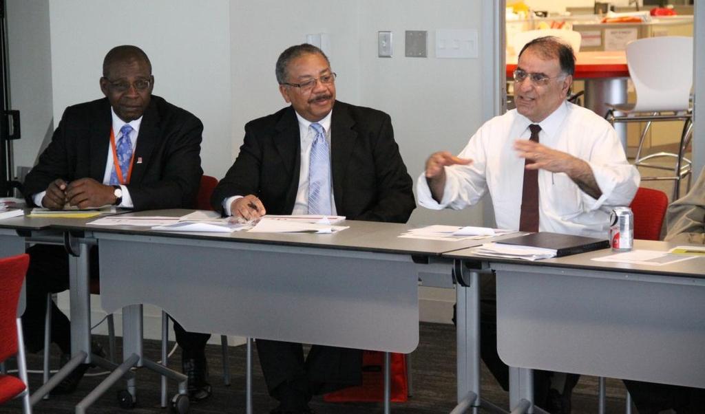
1 RTA 2013 Leadership Briefing and Tour Report Suburban MD, Northern VA, Baltimore, Washington, DC Mike Fendrick, PE, Parsons Brinckerhoff Bill Jenkins, PE, AECOM Mike Surasky, PE, A. Morton Thomas & Associates, Inc.
2 Presented at: RTA Solutions Forum 17: SuperCircles Thursday, August 8, 2013 Hosted by the Research Triangle Park www. letsgetmoving. org Join the conversation on Twitter!
3 Introduction Tour Report Agenda What the Regional Transportation Alliance does Why RTA hosts the Leadership Briefing and Tour Tour overview Trip Elements & Photos Tolled Freeways Freeway Traffic Management Interchanges, intersections, boulevards, and streets Transit (rail & bus) Bicyclists & Pedestrians Key Takeaways Potential Applications for the Triangle Region Conclusion
4 Introduction
5 About the Regional Transportation Alliance RTA mission statement: RTA is the business leadership group that provides a strategic, action-oriented focus and a powerful, collaborative voice to advance regional transportation solutions that will attract top talent, grow our prosperity, and sustain the quality of life for our families and our region.
6 About the Regional Transportation Alliance RTA members and staff focus on: Highlighting crucial projects Catalyzing initiatives Advocating for legislation, policy, referenda Bringing together key players from across the region Identifying pathways to success to keep our region and our economy moving.
7 RTA Leadership Briefings and Tours Suburban Maryland, Northern Virginia, Baltimore, and Washington, DC Cleveland and Pittsburgh Denver Dallas and North Texas San Diego and Orange County All tour reports available at letsgetmoving.org/resources
8 Comparison of the Washington-Baltimore and Raleigh-Durham metropolitan regions
9 Comparison of Regions Washington & Baltimore Raleigh & Durham Area size (sq. miles) 2,638 sq. mi 1,781 sq. mi Population: (Millions) 5.9M + 2.7M = 8.6 M 1.2M + 0.5M = 1.7M Density: (persons/sq. mile) 3, Distance between Cities (miles) Loop Length (miles) I-495 DC Beltway: 64 mi I-695 Baltimore: 52 mi I-440: 16 miles Future NC 540: 71 miles Miles of Freeway 622 miles 87 miles Miles of Freeway / 1M persons 72 miles 51 miles Rail Transit Services 7 heavy rail, 3 light rail & 5 commuter rail lines In study phase only Buses 2,300 buses on over 350 routes 120 routes Total Transit Ridership 1,500,000 pass/day (46% rail, 54% bus) Approx. 35,000 pass/day (primarily bus) Major Airports 3 with 31.5 M passengers/year 1 with 4.5 M passengers/year
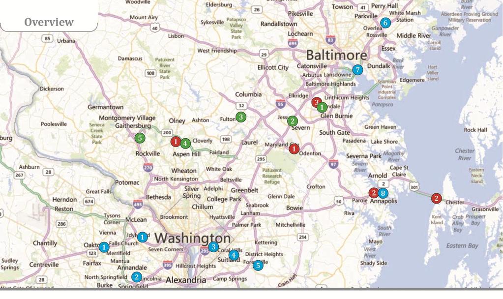
10 2013 RTA Tour Agenda Sunday, May 5 Tuesday, May 7
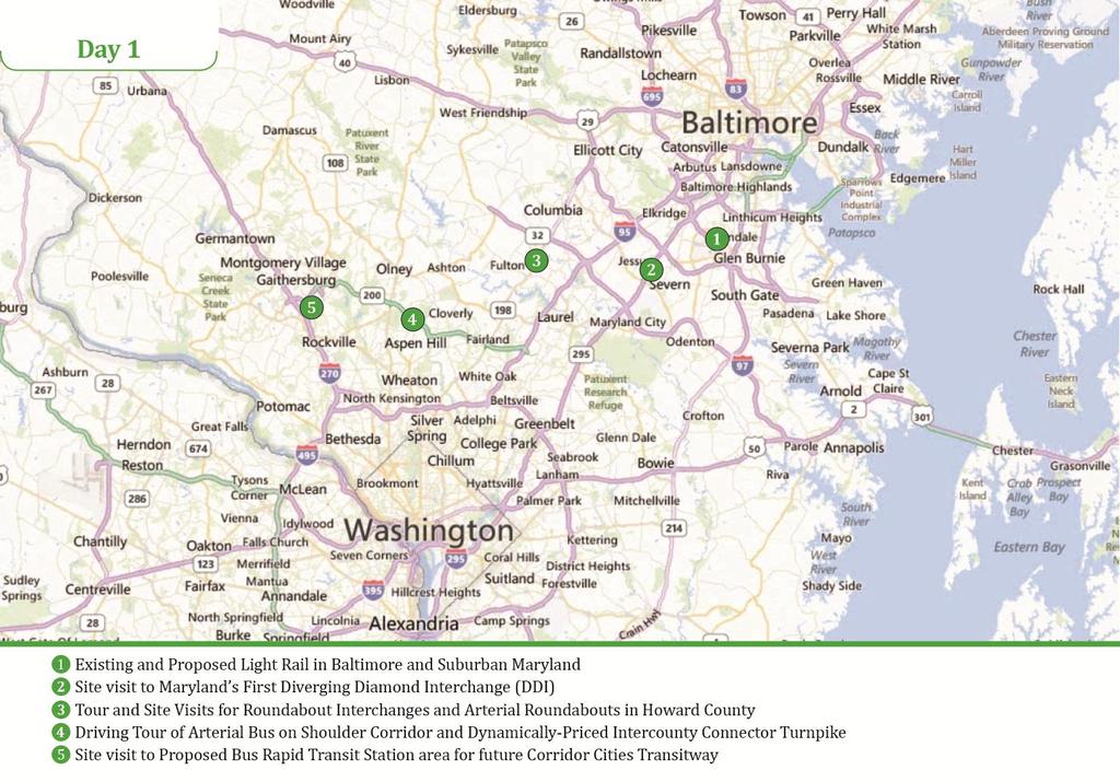
11
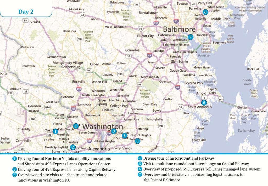
12

13
14
15 Tolled Freeways and Freeway Traffic Management
16 Comparison of Tolled Freeways Features Virginia I-495 Express Lanes Location Base Condition I-495 from Tysons Corner to Springfield Urban freeway with tight ROW Maryland I-95 Express Toll Lanes I-95 north of Baltimore Rural freeway with median Maryland Inter County Connector Suburban eastwest freeway New alignment Ownership Private Entity Public Agency Public Agency Status In operation Opening Fall 2014 In operation Source of Tolls Express lane Express lane All lanes Managed Lanes 4 Buffer separated 4 Barrier separated All lanes HOV Treatment HOV-3 free No HOV or Green discount No HOV or Green discount Tolling Rates Congestion based Time of day based Time of day based Toll Collection E-Z Pass only E-Z Pass & video E-Z Pass & video Operations Center Separate from DOT Regional location Regional location

17 MD 200 Automated Tolling

18 495 Express Lanes Dynamic Tolling

19 495 Express Lanes with Buffer Separation

20 495 Express Lanes Traffic Operations Center
21 All on shoulder Freeway Traffic Management on I-66 in Virginia Outside shoulder used as lane in peak periods on I-66 HOV restrictions 1 lane each direction separated by stripes outside I-495 Exclusive HOV freeway inside I-495 Substantial non-compliance for HOV lanes everywhere Part-time on-ramp meters in Virginia Ramps directly to transit stations in Virginia & Maryland


22 HOV and Shoulder Use Lanes HOV lane (No Tolling) Outside (pink) shoulder lane Used During Rush Hours

23 Part-time On-Ramp Metering I-66 Virginia
24 Freeway Traffic Management on US 50 in Maryland US 50/301 freeway conversion in Maryland Conversion of signalized arterial to non-interstate standard freeway Application of AASHTO minimum vs. desirable standards Lower speed ramps at interchanges Maintain some right in-right out access ramps Reversible lane operations on Chesapeake Bay Bridge

25 Bay Bridge Reversible Lanes
26 Interchanges, Intersections, Boulevards & Streets
27 Interchanges Interchanges, Intersections, Boulevards & Streets Diverging diamond interchange that replaced a roundabout interchange (MD 295) Grade separations for suburban boulevard (US 50 Virginia) Grade separation in urban grid context (DC, at South Capitol Street)
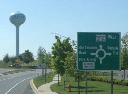
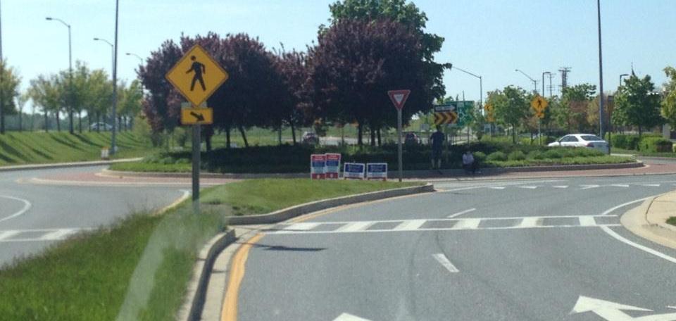
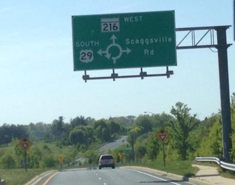
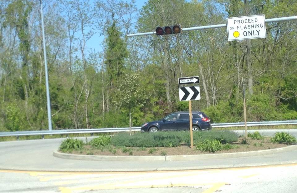
28 Roundabouts Interchanges, Intersections, Boulevards & Streets Statewide "roundabouts considered first" policy (Md. State Highway Admin) Very large roundabout, 3 circulating lanes + bypass lane (I-495 at Ritchie Marlboro Road) Modified SuperCircle (MD Route 100 at Snowden River) Arterial corridor with series of consecutive roundabouts (MD Route 216) Roundabout interchanges along US 29 (including interchange at Johns Hopkins Road)
29 Interchanges, Intersections, Boulevards & Streets Urban Traffic Management HOV lane on urban street (Alexandria, VA) Parking innovations including pay-by-mobilephone (Washington, DC)


30 Diverging Diamond Interchange at MD 295/Arundel Mills
31 Roundabouts
32 Transit: Rail and bus
33 Transit Rail Existing light rail in Baltimore that was originally constructed with 40% single track (Central corridor) Under construction DC Streetcar (Washington DC, near Union Station) Proposed Purple Line in suburban Maryland circumferential light rail with different operating modes in various contexts Forecast to have 69,000 daily riders Goal is to remove 17,000 cars from road
34 Transit Bus Bus on shoulder for signalized arterial (US 29) Existing downtown bus circulator system with $1 fee (DC, multiple routes) Proposed Corridor Cities Transitway bus rapid transit Forecast to have 56,000 daily riders for 15 mile corridor (suburban Montgomery Co ) Proposed premium transit alternatives either bus rapid transit or streetcar (DC)
35 Transit Coordination with Land Use Selling air rights above existing rail facility (DC, near Union Station) Land use along DC Streetcar (Washington DC, near Union Station) Transit-oriented development and median reservation for proposed Corridor Cities Transitway BRT (Montgomery Co) Private port operator (Ports America at Port of Baltimore)


36 BWI light rail & proposed purple line


37 Urban Corridors Urban HOV Lane King Farm Future Transit Corridor

38 DC Streetcar Corridor
39 Bicyclists and Pedestrians
40 Bicyclists & Pedestrians District of Columbia Largest bicycle sharing network in America (regional network in Washington, Northern Va.) Public enclosed bicycle station at Union Station Bicycle rental kiosks with credit cards Greenway trail encircling BWI Airport Greenways important aspects of DC parkways within National Park Service property (e.g. Geo. Washington Parkway in Virginia)
41 Washington, DC DOT Presentation


42 Bike Facilities in DC Capital Bikeshare and Commuter Bike Station
43 Key Takeaways
44 Key Takeaways Across Modes Right-of-way Reservation Right Sizing Openness Data Driven with Key Goals Defined Long Term Focus with Incremental Implementation
45 Managed Lanes Key Takeaways Highways Managed toll lanes allow for direct connection between a demand for faster commute and revenue to pay for it This strategy also lessens the expectations on the normal general purpose lanes since an alternative exists Options on how to encourage vehicle sharing and how to limit the regressive aspects of tolling could be considered HOV discounts to address this concern may minimize revenue, increase enforcement costs, and encourage noncompliance Managed lanes are large projects and require significant forward thinking
46 Key Takeaways Highways Directional Cross Over Interchanges Easier to use than single point urban interchanges plus fewer conflicts, lower costs Roundabout Interchanges / Intersections In the right situations roundabouts work very well These should be evaluated in many locations based on low cost, workability, off-peak delay improvement, and safety
47 Key Takeaways Highways Part-time on-ramp meters Low impact/ lower cost improvement that can preserve freeway capacity Short Term Versus Long Term Creative solutions seem to come out when money is tight Always ask how savings on all projects affects the overall ability to fix more issues
48 Key Takeaways Transit How to Get Started Continuing from 2012 RTA Tour: keys to getting major transit projects started Corridor without many transportation conflicts Or one that can be simultaneously improved Existing and potential transportation demand Land use development objectives and opportunity
49 Key Takeaways Transit Particular transit mode or technology is not super important but frequency, reliability are Again continuing from 2012 RTA Tour lessons, the I ll only ride a train factor seems to be lessening Potential riders seem to be reacting to reliability, frequency, and land use (walkability)
50 Key Takeaways Transit Transit ROW is different than Highway ROW Transit ROW is different from Highway ROW Walkability = proximity of land use, transit corridor = increased transit efficiency, all else equal Can create opposition without neighborhood buy-in Relationship of highway goals to transit goals Many successful transit projects seem to have direct connection to a specific highway corridor
51 Key Takeaways Bicycles Evolved thinking around bikeshare DC Bikeshare uses taxi model not rental car model Where a concessionaire is better Bikeshare technology is easy to get enamored with A kiosk with a bike rental concessionaire would be significantly cheaper and limit government exposure
52 Conclusions and potential applications for our market
53 Conclusions DC & Baltimore have developed multifaceted transportation systems out of need Focus on travel improvement and reliability, not the specific technology Long-term plans with short-term flexibility
54 Potential Applications for the Triangle Freeways Managed (express) lanes Phased improvements Interchanges, intersections, boulevards, and streets Consider roundabouts from initial stages Transit and multimodal transportation Consider all technology types Couple with private development where possible
55 Questions
56 RTA 2013 Leadership Briefing and Tour Report Suburban MD, Northern VA, Baltimore, Washington, DC Mike Fendrick, PE, Parsons Brinckerhoff Bill Jenkins, PE, AECOM Mike Surasky, PE, A. Morton Thomas & Associates, Inc.
1. Operate along freeways, either in regular traffic lanes, in high-occupancy vehicle (HOV) lanes, or along the shoulders.
 lanes, or along the shoulders.") Most decisions about whether or not to use transit involve time and cost, and most transit services are slower than travel by private vehicle. However, when transit is faster or nearly as fast as travel
Most decisions about whether or not to use transit involve time and cost, and most transit services are slower than travel by private vehicle. However, when transit is faster or nearly as fast as travel
North Coast Corridor:
 North Coast Corridor: Connecting People, Transportation & Environment Legislative Hearing: 11.8.10 1 North Coast Corridor Region s Lifeline A Regional Strategy Mobility, Economy & Environment North Coast
A Federal Perspective on Congestion Pricing. Wayne Berman Federal Highway Administration July 8, 2010
 A Federal Perspective on Congestion Pricing Wayne Berman Federal Highway Administration July 8, 2010 Overview Background on Congestion Pricing Benefits and Experiences of Pricing Case Study Miami I-95
Toll Express Lanes for the Research Triangle region Including discussion of possible applications on I-40
 Toll Express Lanes for the Research Triangle region Including discussion of possible applications on I-40 Presentation for discussion at Durham-Chapel Hill-Carrboro MPO TAC meeting Wednesday, December
Washington DC Section of ITE Project Briefing
 Washington DC Section of ITE Project Briefing November 5, 2015 Renée Hamilton, VDOT, Deputy District Administrator I-66 Outside the Beltway Improvement Area Project Location Virginia 2 Purpose and Need
Sketch Level Assessment. of Traffic Issues. for the Fluor Daniel I-495 HOT Lane Proposal. Ronald F. Kirby
 Sketch Level Assessment of Traffic Issues for the Fluor Daniel I-495 HOT Lane Proposal Ronald F. Kirby Director of Transportation Planning National Capital Region Transportation Planning Board (TPB) Metropolitan
Bus Rapid Transit ALTERNATIVES ANALYSIS. Open House
 Bus Rapid Transit ALTERNATIVES ANALYSIS Open House June 23, 2015 Open House Meeting Agenda Agenda Introductions What is BRT? Project Goals Study Tasks Next steps Discussion PVTA Bus Rapid Transit Study
Measuring the Distribution and Costs of Congestion. Tim Lomax Texas Transportation Institute
 Measuring the Distribution and Costs of Congestion Tim Lomax Texas Transportation Institute http://mobility.tamu.edu The Congestion Measurement Story Travel time, variations, compare to goals WHAT? WHY?
2.2 TRANSIT VISION 2040 FROM VISION TO ACTION. Emphasize transit priority solutions STRATEGIC DIRECTION
 TRANSIT VISION 2040 FROM VISION TO ACTION TRANSIT VISION 2040 defines a future in which public transit maximizes its contribution to quality of life with benefits that support a vibrant and equitable society,
Fitting Light Rail through Well-established Communities
 Fitting Light Rail through Well-established Communities San Francisco 2008 Michael D. Madden Chief, Project Development, Maryland Transit Administration Project Setting Located inside the Capital Beltway
Managed Lanes: A National Perspective Managed Lane Strategies
 Managed Lanes: A National Perspective Managed Lane Strategies Use the following control strategies to manage a lane(s) to provide a reliable transportation option: Eligibility/occupancy Access control
Multimodal Through Corridors and Placemaking Corridors
 68 Multimodal Through Corridors and Placemaking Corridors Corridors have different functions in a region. Some corridors are used to get smoothly and rapidly through a region or to get quickly to major
Transportation Master Plan Advisory Task Force
 Transportation Master Plan Advisory Task Force Network Alternatives & Phasing Strategy February 2016 BACKGROUND Table of Contents BACKGROUND Purpose & Introduction 2 Linking the TMP to Key Council Approved
Highway 217 Corridor Study. Phase I Overview Report
 Highway 217 Corridor Study Phase I Overview Report November 3, 24 BACKGROUND AND OVERVIEW Study purpose The Highway 217 Corridor Study is developing multi-modal transportation solutions for traffic problems
BRIEFING ON PROPOSED ADDITIONS AND CHANGES Additions and Changes to Projects Proposed for Inclusion in the 2015 CLRP Update
 BRIEFING ON PROPOSED ADDITIONS AND CHANGES Additions and Changes to Projects Proposed for Inclusion in the 2015 CLRP Update January 23, 2015 Travel Forecasting Subcommittee What is the CLRP? Federally
5. RUNNINGWAY GUIDELINES
 5. RUNNINGWAY GUIDELINES These guidelines should be considered collectively when making runningway decisions. A runningway is the linear component of the transit system that forms the right-of-way reserved
Transform 66 Project February 4, 2016 Partnering Conference Michigan Department of Transportation American Council of Engineering Companies
 Transform 66 Project February 4, 2016 Partnering Conference Michigan Department of Transportation American Council of Engineering Companies Susan Shaw, PE, CCM, DBIA Megaprojects Director Northern Virginia
What if YOU could help plan Northern Virginia s transportation future?
 What if YOU could help plan Northern Virginia s transportation future? Photo credits: Washington Metropolitan Area Transit Authority And improve the quality of life in your community -- for yourself, your
Designing Streets for Transit. Presentation to NACTO Designing Cities Kevin O Malley Managing Deputy Commissioner 10/24/2014
 Designing Streets for Transit Presentation to NACTO Designing Cities Kevin O Malley Managing Deputy Commissioner 10/24/2014 Chicago -- Streets for Transit TODAY Jeffery Jump Transit Signal Priority Central
PERFORMANCE ANALYSIS of The Draft 2015 CLRP
 Item 9 PERFORMANCE ANALYSIS of The Draft CLRP Presentation to the Transportation Planning Board September 16, CLRP Performance Analysis 1 What is the Long-Range Transportation Plan (CLRP)? The CLRP identifies
CITY OF COCOA BEACH 2025 COMPREHENSIVE PLAN. Section VIII Mobility Element Goals, Objectives, and Policies
 CITY OF COCOA BEACH 2025 COMPREHENSIVE PLAN Section VIII Mobility Element Goals, Objectives, and Policies Adopted August 6, 2015 by Ordinance No. 1591 VIII MOBILITY ELEMENT Table of Contents Page Number
Regional Transportation Needs Within Southeastern Wisconsin
 Regional Transportation Needs Within Southeastern Wisconsin #118274 May 24, 2006 1 Introduction The Southeastern Wisconsin Regional Planning Commission (SEWRPC) is the official areawide planning agency
Agenda. Overview PRINCE GEORGE S PLAZA METRO AREA PEDESTRIAN PLAN
 PRINCE GEORGE S PLAZA METRO AREA PEDESTRIAN PLAN May 28, 2008 Agenda Welcome and introductions Project overview and issue identification Planning context and strengths Design challenges and initial recommendations
Dulles Area Transportation Association. October 11, Susan Shaw, P.E., Megaprojects Director Virginia Department of Transportation
 Dulles Area Transportation Association October 11, 2017 Susan Shaw, P.E., Megaprojects Director Virginia Department of Transportation Transform 66: Outside the Beltway 2 Project Overview Multimodal improvements
City of Fairfax, Virginia City Council Work Session
 City of Fairfax, Virginia City Council Work Session Agenda Item # 4c City Council Meeting 6/2/2015 TO: FROM: SUBJECT: Honorable Mayor and Members of City Council Robert Sisson, City Manager Discussion
Presentation of Staff Draft March 18, 2013 COUNTYWIDE TRANSIT CORRIDORS FUNCTIONAL MASTER PLAN
 Presentation of Staff Draft March 18, 2013 COUNTYWIDE TRANSIT CORRIDORS FUNCTIONAL MASTER PLAN Public Outreach Fall 2011: Two community meetings/open houses Fall 2012: Three community meetings/open houses
FY Transportation Capital Improvement Plan Update Arlington Committee for Transportation Choices
 FY 2017-2026 Transportation Capital Improvement Plan Update Arlington Committee for Transportation Choices November 1, 2017 Forecasted Growth Arlington continues to grow with a shift towards multi-family
MONTGOMERY COUNTY PLANNING DEPARTMENT THE MARYLAND-NATIONAL CAPITAL PARK AND PLANNING COMMISSION
 MONTGOMERY COUNTY PLANNING DEPARTMENT THE MARYLAND-NATIONAL CAPITAL PARK AND PLANNING COMMISSION MCPB Item No. 4 Date: 09-10-15 Scope of Work for the Bicycle Master Plan David Anspacher, Planner/Coordinator,
A Selection Approach for BRT Parking Lots Nicolls Road Corridor Parking Study
 A Selection Approach for BRT Parking Lots Nicolls Road Corridor Parking Study Chirantan Kansara, P.E. Engineering Construction Design Planning 2018 ITE Northeastern District Annual Meeting Lake George,
Metropolitan Council Transportation Committee
 Nicollet-Central Transit Alternatives Metropolitan Council Transportation Committee August 2013 Project Purpose (approved by Policy Advisory Committee 10/25/2012) The purpose is to improve transit connectivity,
Bus Rapid Transit Plans
 Twin Cities Region Bus Rapid Transit Plans ULI Minnesota Workshop Connecting Bus Rapid Transit to the Community December 15, 2009 John Levin Director of Service Development Metro Transit Metropolitan Area
MOVEABLE BARRIER. Congestion Management Solutions
 MOVEABLE BARRIER Congestion Management Solutions 1 Portland area morning congestion (AM) 2 Portland area afternoon congestion (PM) 3 30 year planning - Portland Area 100% Growth over 30 years 4 Movable
PRINCE GEORGE S PLAZA METRO AREA PEDESTRIAN PLAN
 PRINCE GEORGE S PLAZA METRO AREA PEDESTRIAN PLAN May 28, 2008 Agenda Welcome and introductions Project overview and issue identification Planning context and strengths Design challenges and initial recommendations
Washington Metropolitan Area Transit Authority Board Action/Information Summary
 Washington Metropolitan Area Transit Authority Board Action/Information Summary Action Information MEAD Number: 200242 Resolution: Yes No TITLE: MWCOG Strategic Investment Plan & TPB Priorities PRESENTATION
I-35W Solutions Alliance Project Update July 13, 2017
 Title I-35W Solutions Alliance Project Update July 13, 2017 Evaluating the potential for Bus Rapid Transit and MnPASS Express Lanes in the southwest Metro, Investigating options for improved bus service
Measuring and Communicating Mobility:
 Measuring and Communicating Mobility: The District Mobility Project Stephanie Dock, District Department of Transportation TRB Transportation Issues in Major Cities Committee May 2, 2017 Deconstructing
Transportation, Parking & Roads
 Transportation, Parking & Roads Design Carolina North as a walkable community Design the transportation system and development patterns (i.e., urban design elements such as density, building design, mix
November 14, Dulles To DC Loop Public-Private Partnership Proposal. Executive Summary
 November 14, 2005 Dulles To DC Loop Public-Private Partnership Proposal Executive Summary Virginia Mobility Associates LLC, a newly established single purpose entity, proposes to privately finance the
Governor s Transportation Vision Panel
 Office of Governor Kate Brown Governor s Transportation Vision Panel JLA Public Involvement Project Overview The is a yearlong effort to develop a series of recommendations for the Governor that address
Route 29 Solutions Projects
 Route 29 Solutions Route 29 Solutions Projects www.route29solutions.org October 10, 2014 Route 29 Widening to Six Lanes Albemarle County This project will widen a 1.8-mile segment of Route 29 from four
ACTIVE TRANSPORTATION
 ACTIVE TRANSPORTATION Mobility 2040 Supported Goals Improve the availability of transportation options for people and goods. Support travel efficiency measures and system enhancements targeted at congestion
York Region Population and Employment Growth
 March 1, 2016 1 York Region Population and Employment Growth York Region needs to comply with The Provincial Growth Plan and new forecasts introduced to 2036 and 2041 2 Regional Official Plan Review York
Chapter 6 Transportation Plan
 Chapter 6 Transportation Plan Transportation Plan Introduction Chapter 6 Transportation Plan Transportation Plan Introduction This chapter describes the components of Arvada s transportation system, comprised
2. Context. Existing framework. The context. The challenge. Transport Strategy
 Transport Strategy Providing quality connections Contents 1. Introduction 2. Context 3. Long-term direction 4. Three-year priorities 5. Strategy tree Wellington City Council July 2006 1. Introduction Wellington
Project Description Form 6V
 Project Description Form 6V Basic Project Information Submitting Jurisdiction/Agency: Prince William County Project Title: Route 15 Widening: Route 55 to south of RR tracks & Construct RR Overpass Project
Short-Term Enhancements Improvements to keep Austin moving. MetroRapid
 Short-Term Enhancements Improvements to keep Austin moving Long-Term Investments Projects to support our future Mobility Hubs MetroRapid MetroRail MetroExpress Commuters Connectors Circulators Project
2045 Long Range Transportation Plan. Summary of Draft
 2045 Long Range Transportation Plan Summary of Draft Fredericksburg Area Metropolitan Planning Organization The George Washington Region includes the City of Fredericksburg and the counties of Caroline,
ROADSOADS CONGESTION HAMPTON SYSTEMYSTEM MANAGEMENT. Part II Roadway Congestion Analysis Mitigation Strategies and Evaluation
 HAMPTON ROADSOADS CONGESTION MANAGEMENT SYSTEMYSTEM Part II Roadway Congestion Analysis Mitigation Strategies and Evaluation Presented by: Dwight Farmer, PE Deputy Executive Director, Transportation April
Institute for Real Estate Management Chapter (IREM) 77 VDOT Northern Virginia Megaprojects September 13, 2017
 77 VDOT Northern Virginia Megaprojects September 13, 2017") Institute for Real Estate Management Chapter (IREM) 77 VDOT Northern Virginia Megaprojects September 13, 2017 Susan Shaw, P.E., Megaprojects Director Virginia Department of Transportation Northern Virginia
Institute for Real Estate Management Chapter (IREM) 77 VDOT Northern Virginia Megaprojects September 13, 2017 Susan Shaw, P.E., Megaprojects Director Virginia Department of Transportation Northern Virginia
Priced Managed Lanes in America. October 2013
 Priced Managed Lanes in America October 2013 1 Priced Managed Lanes What are they? Where are they? Why do them? When to do them? Common issues Lessons learned What are Priced Managed Lanes? The subset
Freeway System Considerations
 Session 11 Jack Broz, PE, HR Green May 5-7, 2010 Freeway System Considerations Mainline Transit: Shoulder Operations, BRT, Stations HOV, HOT, UPA Interchanges Exit Ramps Entrance Ramps Bridges Local Crossings
Roadways. Roadways III.
 Introduction 97 Roadway Design Principles 98 Safe Speeds 99 Optimizing of Street Space 00 Minimum Lane Widths in the City of Boston 02 Design Features that Reduce Operating Speeds 05 Travel Lanes Transit
South King County High-Capacity Transit Corridor Study
 HIGH-CAPACITY TRANSIT CORRIDOR STUDY South King County Corridor South King County High-Capacity Transit Corridor Study Corridor Report August 2014 South King County High Capacity Transit Corridor Report
Chapter 5 Future Transportation
 Chapter 5 Future Transportation The Future Land Use Plan identifies the desired land use designations. The land uses desired for Crozet depend, in large part, on the success of the transportation system,
ADVANCED TRANSIT OPERATIONS AND MODELING
 SOUTHERN DISTRICT OF INSTITUTE OF TRANSPORTATION ENGINEERS (SDITE) 2017 ADVANCED TRANSIT OPERATIONS AND MODELING SURESH KARRE, PE, PTOE ROBERT DUBNICKA, PE, TE, PTOE AGENDA Background Transit operations
Cherry Creek Transportation and Land Use Forum September 25, 2013 Meeting Summary
 Cherry Creek Transportation and Land Use Forum September 25, 2013 Meeting Summary I. LEAD-IN TO SMALL GROUP DISCUSSION, POLLING AND STEERING COMMITTEE/TECHNICAL TASK FORCE DISCUSSION The meeting began
I-264 CORRIDOR EVALUATION STUDY. September 7, 2016 Eric Stringfield VDOT Planning Director Chris Lawrence AECOM Senior Transportation Engineer
 I-264 CORRIDOR EVALUATION STUDY September 7, 2016 Eric Stringfield VDOT Planning Director Chris Lawrence AECOM Senior Transportation Engineer Study Overview Interchange Locations Study Context Follow-up
Who is Toole Design Group?
 2018 AASHTO Bike Guide Status Update NCHRP 15 60 Amalia Leighton Cody, PE, AICP & Kenneth Loen, PE Washington APWA October 4, 2018 Who is Toole Design Group? TDG is a full service engineering, planning
REDWOOD CITY STREETCAR - ALTERNATIVES ANALYSIS
 REDWOOD CITY STREETCAR - ALTERNATIVES ANALYSIS The purpose of this document is to ennumerate the analysis of alternatives for a streetcar along the Broadway Corriodor of Redwood City. The six alternatives
Previous Transit Studies MTTF MEETING #
 Previous Transit Studies MTTF MEETING #4 2013-03-22 Agenda Project timeline Final transit recommendation (2011) Transit planning and development (2002 2011) Moving forward (2011 2013) 2 Project Timeline
Key objectives of the survey were to gain a better understanding of:
 3 COMMUNITY INPUT Community input is an essential part of corridor studies. For the SR 87 corridor study, VTA staff conducted an extensive online survey of people living and commuting along the corridor.
DDI s Can Move More Than Cars! 2016 Western ITE Conference Albuquerque, NM July 12, 2016 Alex Ariniello, P.E. Public Works Director, Town of Superior
 DDI s Can Move More Than Cars! 2016 Western ITE Conference Albuquerque, NM July 12, 2016 Alex Ariniello, P.E. Public Works Director, Town of Superior Overview How did we get to the DDI concept? What s
Transit-Driven Complete Streets
 Questions: Type questions into the box at bottom of webinar panel. Panelists for today s webinar: Nimotalai Azeez, Program Associate with the National Complete Streets Coalition Rich Weaver, Director of
EXECUTIVE SUMMARY... vii 1 STUDY OVERVIEW Study Scope Study Area Study Objectives
 Contents EXECUTIVE SUMMARY... vii 1 STUDY OVERVIEW... 1-1 1.1 Study Scope... 1-1 1.2 Study Area... 1-1 1.3 Study Objectives... 1-3 2 EXISTING CONDITIONS... 2-1 2.1 Existing Freeway Conditions... 2-4 2.1.1
THE FUTURE OF THE TxDOT ROADWAY DESIGN MANUAL
 THE FUTURE OF THE TXDOT ROADWAY DESIGN MANUAL Kenneth Mora, P.E. (Design Division) 10/10/2017 Table of contents 1 2 Reduction in FHWA design controlling criteria Innovative Intersection Guidance 3-7 8-42
BUS RAPID TRANSIT. A Canadian Perspective. McCormick Rankin International. John Bonsall P.Eng
 BUS RAPID TRANSIT A Canadian Perspective Why choose BRT? Because it is a practical and cost effective rapid transit solution for the most common types of land use in urban Canada Operating experience shows
Transit Signal Priority (TSP) Application to Miami-Dade Transit
 Application to Miami-Dade Transit") Transit Signal Priority (TSP) Application to Miami-Dade Transit Amar Sarvepalli Parsons Brinckerhoff Southeast Florida FSUTMS Users Group August 15, 2008 Overview PART A WHAT IS TSP INTRODUCTION PURPOSE
Transit Signal Priority (TSP) Application to Miami-Dade Transit Amar Sarvepalli Parsons Brinckerhoff Southeast Florida FSUTMS Users Group August 15, 2008 Overview PART A WHAT IS TSP INTRODUCTION PURPOSE
Balancing Operation & Safety for Motorized and Non-Motorized Traffic
 Balancing Operation & Safety for Motorized and Non-Motorized Traffic Brian Willham, PE, PTOE Iowa Director - MOVITE June 30, 2014 Learning Objectives: When & Why should we measure the performance of complete
Joseph Iacobucci. James Czarnecky, AICP
 Chicago s Bus Rapid Transit Program Joseph Iacobucci Chicago Transit Authority Manager, Strategic Planning and Policy Chicago, IL James Czarnecky, AICP AECOM BRT Program Manager Chicago, IL Chicago s Multimodal
Corpus Christi Metropolitan Transportation Plan Fiscal Year Introduction:
 Introduction: The Safe, Accountable, Flexible, Efficient Transportation Equity Act: A Legacy for Users (SAFETEA-LU) has continued the efforts started through the Intermodal Surface Transportation Efficiency
INFRASTRUCTURE: Using the Grid to Create a more Self-Sustaining Downtown. Studio Spring 2013
 EMERGENT FUTURES The San Diego Section of the American Society of Civil Engineers (ASCE) released a new report, the 2012 San Diego County Infrastructure Report Card. Since the last San Diego Report Card
Arlington County 10-Year Transit Development Plan & Premium Transit Network Briefing. May 2016
 Arlington County 10-Year Transit Development Plan & Premium Transit Network Briefing May 2016 Overview 10-Year Transit Development Plan Premium Transit Network Columbia Pike service concept Premium amenities
ALTERNATIVES ANALYSIS EXECUTIVE SUMMARY
 West Valley Connector Corridor ALTERNATIVES ANALYSIS EXECUTIVE SUMMARY FINAL September 2014 Ontario International Airport Ontario Mills Rancho Cucamonga Metrolink Station Kaiser Permanente PARSONS EXECUTIVE
STREET AND HIGHWAY PLAN
 STREET AND HIGHWAY PLAN Introduction The street and highway system in the Winston-Salem Urban Area consists of thousands of miles of traffic carrying facilities, ranging from short local residential streets
ROUTES 55 / 42 / 676 BUS RAPID TRANSIT LOCALLY PREFERRED ALTERNATIVE
 ROUTES 55 / 42 / 676 BUS RAPID TRANSIT LOCALLY PREFERRED ALTERNATIVE April, 2012 1 INTRODUCTION The need for transit service improvements in the Routes 42/55/676 corridor was identified during the Southern
DULLES AREA TRANSPORTATION ASSOCIATION (DATA) February 18, Susan Shaw, P.E., VDOT, Megaprojects Director
 February 18, Susan Shaw, P.E., VDOT, Megaprojects Director") DULLES AREA TRANSPORTATION ASSOCIATION (DATA) February 18, 2015 Susan Shaw, P.E., VDOT, Megaprojects Director I-66 Corridor Conditions Steady population growth Employment growth in activity centers Congestion
DULLES AREA TRANSPORTATION ASSOCIATION (DATA) February 18, 2015 Susan Shaw, P.E., VDOT, Megaprojects Director I-66 Corridor Conditions Steady population growth Employment growth in activity centers Congestion
Public Opinion about Transportation Issues in Northern Virginia
 Public Opinion about Transportation Issues in Northern Virginia Research and Strategy Presented to: The Northern Virginia Transportation Authority July 28, 2005 Research Objectives 1. Travel Patterns*
Public Information and Participation Comments
 Two public meetings were held in December. The first meeting was December 6, 2011 at Mary Ellen Henderson Middle School and had 36 public attendees. The second meeting was on December 14, 2011 at the Arlington
Capital Beltway HOT Lanes - Frequently Asked Questions
 Capital Beltway HOT Lanes - Frequently Asked Questions December 20, 2007 1. What is the cost of the project? The fixed-price design-build cost is approximately $1.4 billion. 2. Why have the project costs
Purpose and Need. Chapter Introduction. 2.2 Project Purpose and Need Project Purpose Project Need
 Chapter 2 Purpose and Need 2.1 Introduction The El Camino Real Bus Rapid Transit (BRT) Project (Project) would make transit and other transportation improvements along a 17.6-mile segment of the El Camino
Charlotte Region Fast Lanes Study Phase III
 Charlotte Region Fast Lanes Study Phase III Stakeholder Workshop #3 December 13, 2012 Fast Lanes Study, Phases I and II Performed between 2007 and 2009 Evaluated all types of managed lanes (HOV, HOT, truck-only
Better Market Street Project Update. Urban Forestry Council September 17, 2014
 Better Market Street Project Update Urban Forestry Council September 17, 2014 Project Area Limits Better Market Street Schedule Market Street City s busiest transit corridor Over 85 buses per hour 14 surface
Clackamas County Comprehensive Plan
 ROADWAYS The County s road system permits the movement of goods and people between communities and regions, using any of a variety of modes of travel. Roads provide access to virtually all property. They
A COMPREHENSIVE APPROACH TO TRANSPORTATION AT SUNTRUST PARK AND THE BATTERY ATLANTA
 A COMPREHENSIVE APPROACH TO TRANSPORTATION AT SUNTRUST PARK AND THE BATTERY ATLANTA Overview The Atlanta Braves strategically selected the location for SunTrust Park to provide an environment rich in transportation
TRANSIT PERFORMANCE IN THE I-66 INSIDE THE BELTWAY CORRIDOR
 TRANSIT PERFORMANCE IN THE I-66 INSIDE THE BELTWAY CORRIDOR June 2018 This report summarizes the performance of public transportation systems serving the I-66 inside the Beltway corridor in Northern Virginia.
It s Been 15 Years Already?!
 It s Been 15 Years Already?! What We ve Learned from 12 Operational Facilities 14 Parsons Brinckerhoff, 2012. THEY WORK! May 24, 2012 Parsons Brinckerhoff, 2012. 2 David Ungemah ungemah@pbworld.com May
PEDESTRIAN ACCOMMODATIONS DPS 201 AT INTERCHANGES
 PEDESTRIAN ACCOMMODATIONS DPS 201 AT INTERCHANGES UNDERSTANDING THE ISSUES Intersections of freeway ramp terminals at crossroads are the most critical components of an interchange Challenge: balance mobility
12 RECOMMENDATIONS Road Improvements. Short Term (generally the next five years)
") 12 RECOMMENDATIONS Recommendations are based on the technical analysis of existing and future road and active transportation conditions, the results of the review of existing City policies and public feedback.
12 RECOMMENDATIONS Recommendations are based on the technical analysis of existing and future road and active transportation conditions, the results of the review of existing City policies and public feedback.
Proposed Project I 35 from Denton to Cooke County Line
 Proposed Project I 35 from Denton to Cooke County Line The existing I 35 facility is four lanes from I 35E/I 35W to Farm to Market Road (FM) 3002. The purpose of the proposed project is to increase capacity
Broadway Complete Streets Project
 Broadway Complete Streets Project Megan Johnson, P.E. Associate Civil Engineer James Pangburn, P.E. Consultant Project Manager After the construction of the highway system, Broadway was cut off
State Highway 44/State Street High Capacity Corridor
 Background State Highway 44/State Street runs from I-84 in Canyon County through parts of the cities of Middleton, Star, Eagle, and Garden City to downtown Boise. It is a commuter route from several communities
In station areas, new pedestrian links can increase network connectivity and provide direct access to stations.
 The Last Mile Planning for Pedestrians Planning around stations will put pedestrians first. Making walking to stations safe and easy is important; walking will be a part of every rapid transit Accessible
DON MILLS-EGLINTON Mobility Hub Profile
 Mobility Hub Profile Dundas Don Mills-Eglinton West-Bloor Anchor Hub Gateway Hub N MOBILITY HUBS: Places of connectivity between regional and rapid transit services, where different modes of transportation
Corridor Advisory Group and Task Force Meeting #10. July 27, 2011
 Corridor Advisory Group and Task Force Meeting #10 July 27, 2011 1 Agenda Recap CAG/TF #9 Public Meeting #2 Summary Single Mode Alternatives Evaluation Results Next Steps 2 3 CAG/TF #9 Recap CAG /TF #9
Typical Rush Hour Commute. PennyforTransportation.com
 Typical Rush Hour Commute In the News Overview of the Plan Collaborative plan with projects in every community Prioritizing connectivity and congestion relief Dedicated transportation-specific funding;
MCTC 2018 RTP SCS and Madera County RIFP Multi-Modal Project Eval Criteria GV13.xlsx
 MCTC 8 RTP SCS and Madera County RIFP Multi-Modal Project Eval Criteria GV.xlsx Madera County Transportation Commission Regional Transportation Plan / Sustainable Communities Strategy Multi-Modal Project
Durham Region Long Term Transit Strategy
 Durham Region Long Term Transit Strategy An adaptive, safe, reliable, frequent, accessible and desirable transit system that shapes and connects Durham Region and beyond in an economically and environmentally
Vision Public Workshop: Findings
 Vision Public Workshop: Findings Long Range Transportation Plan & Bicycle Mobility Plan February 2018 Vision Workshop South Kingstown 1/23/18 Providence 1/24/18 Newport 1/31/18 Long Range Transportation
Corridor Studies. LA 415 and LA 73
 Corridor Studies LA 415 and LA 73 Project Approach for Both Corridors 1. Data Collection 2. Data Summary 3. Traffic Analysis 4. Micro-Simulation modeling 5. Generation of alternatives 6. Modeling alternatives
Federal Highway Administration Pedestrian Safety Guidance for Transit
 Federal Highway Administration Pedestrian Safety Guidance for Transit Dan Nabors Vanasse Hangen Brustlin, Inc. September 23, 2009 Pedestrian Safety Tools & Techniques Pedestrian Safety Guidebooks Transit