Highway 17 Transportation Improvement Study
|
|
|
- Kimberly Moore
- 5 years ago
- Views:
Transcription
1
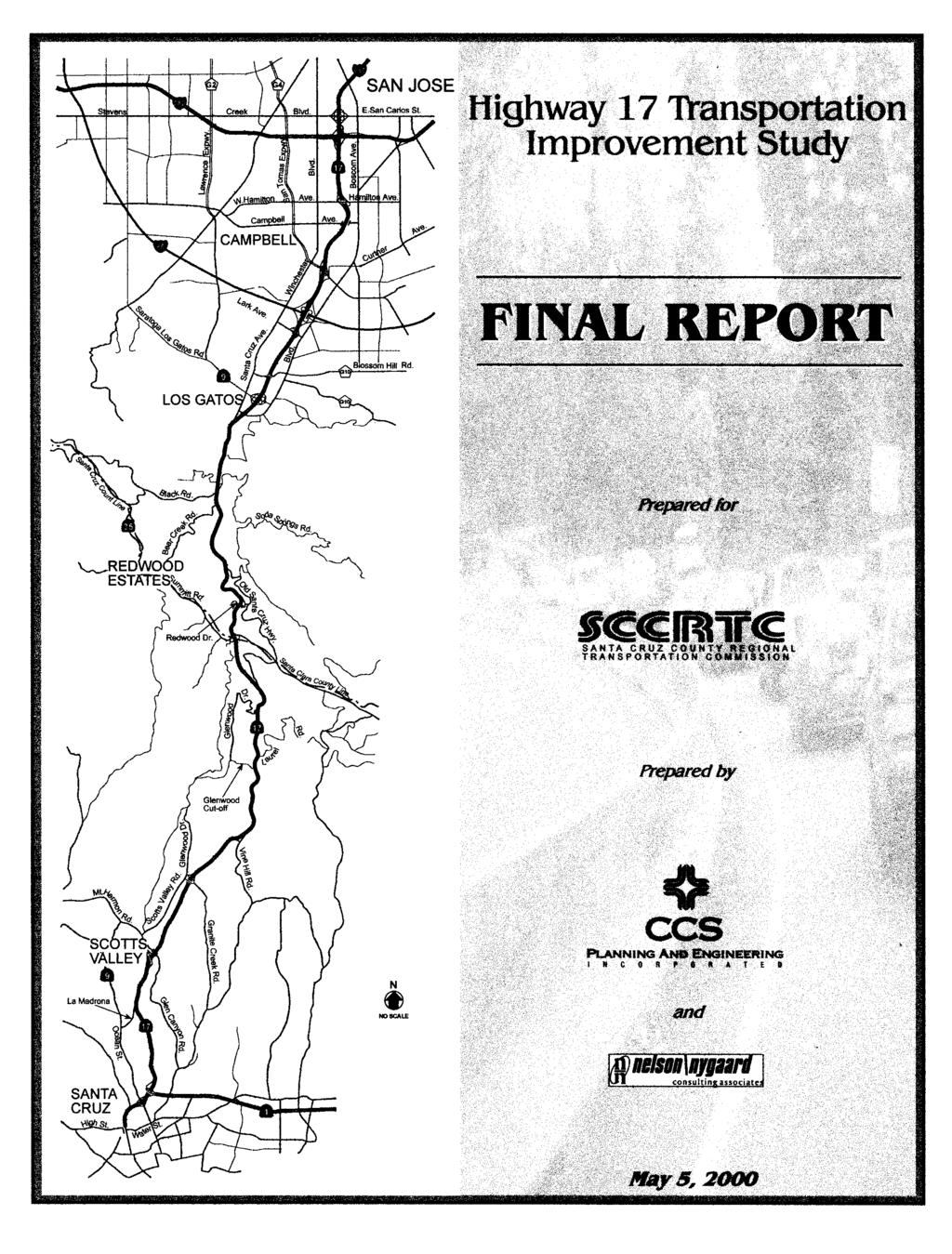
2 Final Report Highway 17 Transportation Improvement Study prepared for Santa Cruz County Regional Transportation Commission (SCCRTC) prepared by Planning and Engineering, Inc North First Street, Suite 100 San Jose, CA (408) and Nelson/Nygaard Consulting Associates 833 Market Street, Suite 900 San Francisco, CA (415) May 5, 2000
3 TABLE OF CONTENTS SECTION PAGE EXECUTIVE SUMMARY 1 STUDY OVERVIEW Introduction 1-1 Process 1-4 Current Projects Being Implemented 1-5 Presentation Format HIGHWAY ISSUES, CONSTRAINTS AND IMPROVEMENT OPPORTUNITIES Highway Operations Issues 2-1 Recommended Improvement Options 2-7 Improvement Evaluation 2-21 Summary of Recommended Options 2-21 Implementation SUGGESTED TRANSIT SERVICE IMPROVEMENTS Introduction 3-1 Issues -3 Preliminary Analysis for Future Expansion 3-4 Summary of Recommendations 3-9 Next Steps 3-16 Cost Allocation Methods MARKETING 5 FUNDING Potential Fund Sources for Highway Improvements 5-1 Potential Fund Sources for Transit Improvements CONCLUSION TABLES 1 Improvement Evaluation Matrix Recommended Improvement Plan Highway 17 Express Bus Ridership Total: 1990/ / Estimate of Santa Cruz County Residents Working in Santa Clara County Summary of Santa Cruz County Commuters by corridor Potential Capital Improvements 3-12 Highway 17 Transportation Improvement Study Final Report i Ma. y
4 TABLE OF CONTENTS (Continued) FIGURES PAGE 1 Vicinity Map High Accident Locations Road Closures Locations of Heavy Congestion Recommended Localized Improvements Major Employment Centers Existing Park and Ride Lots and Transit Centers 3-8 TECHNICAL APPENDIX TO FINAL REPORT (Available as a Separate Booklet) A B C D E Study Participants Caltrans Documentation - Safe on 17 Task Force Corridor Assessment - Caltrans Status of Minor B Projects - Caltrans Highway Safety Improvement Program Highway Operations Issues Marketing Air Pollution Control District Key Service Measurements Highway 17 Transportation Improvement Study Final Report ii May
5 EXECUTIVE SUMMARY BACKGROUND INFORMATION State Highway Santa Cruz s famous over the Hill highway -- is by far the most direct and shortest route between Santa Cruz County and almost all commuting destinations in Santa Clara, Alameda, Contra Costa and much of San Mateo Counties. In addition, Highway 17 is the primary route of choice between the Santa Clara Valley and the recreational areas of Santa Cruz on summer weekends. Congestion occurs both during weekday commute times and on summer weekends. This winding, four-lane road has steep sections, frequent road crossings, and substandard median shoulders and outside shoulders for most of its length. In addition to the challenging roadway configuration, weather-related conditions such as thick fog, heavy rains and mudslides affect roadway operations. Reconstruction of the highway to meet current standards would be both exorbitantly expensive and environmentally destructive. Thus, over the past two decades, the Santa Cruz County Regional Transportation Commission (SCCRTC) has consistently opted to keep Highway 17 a four-lane highway, targeting funds for safety and operational improvements. In the late 1980s and again last year, SCCRTC worked with Caltrans and the California Highway Patrol (CHP) to identify low cost safety and operational improvements and to implement a safety campaign for Highway 17. Median barriers, acceleratioddeceleration lanes, motorist call boxes and changeable message signs are improvements that have been installed over the past decade. The Highway 17 Express Bus service was initiated after the 1989 Loma Prieta earthquake in response to an emergency need for transit over the Hill while Highway 17 was being repaired. This joint project of the Santa Cruz Metropolitan Transit District (SCMTD) and the Santa Clara Valley Transportation Authority (VTA) has been a success since its inception. Nine transit coaches were acquired with Federal Emergency Management Agency (FEMA) funding and were therefore not subject to various contractual and statutory limitations affecting transit vehicles Highway I7 Transportation Improvement Study Final Report ES- I May 5, 2000
6 purchased through conventional Federal Transit Administration (FTA) transit operator sources. During the course of this study, SCMTD, the Santa Cruz County bus operator, agreed to take over the day-to-day operations of the service using its drivers and facilities, thereby achieving the most important goal of this study - how to continue the existing service. VTA transit is participating in the funding and oversight of the service through a Joint Powers Authority arrangement with SCMTD. With the continued operation of the existing Highway 17 Express Bus service secured, this Highway 17 Transportation Improvement Study focused on optimizing and expanding the Highway 17 Express Bus service. PURPOSE OF THE STUDY In response to the need for safety and reliability improvements in this corridor, the Highway 17 Transportation Improvement Study was conducted to provide SCCRTC, VTA, and SCMTD with a review of available data, past studies and proposals, and to recommend safety and efficiency improvement projects with the following two main objectives: 1) Recommend steps to optimize the Highway 17 Express Bus service reliability. 2) Expand Highway 17 Express Bus ridership in the corridor in order to reduce vehicle trips, miles traveled, and emissions. Recognizing that the roadway and traffic conditions along Highway 17 affect the operation of the Highway 17 Express Bus service, an additional objective was to recommend safety and operational improvements to add reliability, speed and functionality to the project corridor to benefit both the patrons of the Highway 17 Express Bus service and the motorists traveling along this route. STUDY PROCESS A Technical Advisory Committee (TAC) was established to aid in the completion of this study. The TAC consisted of representatives from SCCRTC, SCMTD, VTA, Caltrans Districts 4 and 5, the Monterey Bay Unified Air Pollution Control District (MBUAPCD), the City of Scotts Valley, the Metropolitan Transportation Commission (MTC), the Association of Monterey Bay Area Governments (AMBAG), and the California Highway Patrol (CHP). The TAC provided input, review and guidance in the development of this study. A full listing of study participants is shown in Appendix A. The TAC coordinated with the Safe on 17 Task Force, a task force spearheaded by the California Highway Patrol that emphasizes safety improvements along Highway 17. The Safe on 17 Task Force provided input/responses to suggestions, logs of programmed projects and recently completed improvements, and information from the ongoing Accident Surveillance System, as part of the California Highway Safety Improvement Program. Highway 17 Transportation Improvement Study Final Report ES-2 May 5, 2000
7 TRANSIT IMPROVEMENT RECOMMENDATIONS The original focus of the transit portion of this study was intended to be in three key areas: 1) Explore means to continue operating the Highway 17 Express Bus service beyond the expiration of the service contract with Discovery Charters in June of ) Explore changes to optimize the existing service using current resources. 3) Describe the potential to expand service in the corridor, including reaching out to new markets. The first issue became moot during the course of the study when METRO and VTA formed a Joint Powers Authority to jointly oversee the service, with METRO operating it with its own drivers and vehicles. The JPA agreement establishes a Service Review Committee to set budgets, policy, and fares, and to explore service augmentations, new routes, vehicle funding, procurement and other issues that arise. This arrangement has been extremely successful to date. For the purposes of making service optimization and expansion suggestions, the Study Team analyzed a variety of existing data sources, interviewed agency staff and conducted several reconnaissance trips during the course of the analysis. Based on an analysis of the existing data, the following key recommendations merit further discussion (by the new Service Review Committee established by VTA and METRO for operating the Highway 17 Express Bus service under the new Joint Powers Authority) or investigation: Maintain existing service Consider adding new service to connect with Metro Center Consider incremental improvements to existing services Continue to explore reverse commute potential Begin planning for new service south of Soquel Continue to implement incremental capital improvements Avoid any increase in transit travel time Consider breaking service into different routes Continue to review and refine interconnectivity with other services Continue to promote vanpools and subscription bus services Consider weekend service in corridor Highway Operations and Capital Improvements Regardless of whether the existing Highway 17 Express Bus service is continued, optimized, or expanded, transit services are dependent on the reliability of travel conditions along the Highway 17 corridor. During peak periods, in the peak direction, drivers (both automobile and bus drivers) experience intermittent delays, often minutes in length, for a trip of about 20 miles between Santa Cruz and Los Gatos. North of Los Gatos, routine congestion can add another 5-10 minutes to the travel time between Los Gatos and San Jose. Highway I7 Transportation Improvement Study Final Report ES- 3 May 5, 2000
8 The primary cause of delays on the Highway 17 Corridor is traffic incidents rather than recurrent congestion. Though protected from head-on collisions by a nearly continuous concrete median barrier, the corridor s curves, insufficient superelevation, dips, steep grades and other geometric conditions are associated with localized accident rates. Along some of the mountainous portions of Highway 17, travel lanes are not the standard width for new facilities. The existing lane width in these areas is 11.5 feet, while the current standard for basic lane width is 3.6 meters or feet. Accidents, stalls and breakdowns in segments without shoulders or pullouts quickly create long queues and subsequent slowdowns lasting long afterwards. Highway 17 is a four-lane facility through the study area. Because of right-of-way constraints and the mountainous terrain, widening Highway 17 would be costly and environmentally prohibitive. Therefore, there is no effective way to significantly increase vehicle capacity on this roadway. Additionally, highway operational problems, including high numbers of accidents and road closures, affect the reliability of the Highway 17 Express Bus service, and general travel along the corridor. These problems are largely attributed to three factors: Excessive speed for geometric condition Excessive speed for weather conditions Congestion at bottlenecks The recommended highway operations and capital improvements for Highway 17 focus on a system-wide approach consisting of the following four major implementation programs: Speeding Prevention and Enforcement Safety Improvements Incident Prevention and Management Geometric Improvements Some of the options for improvement are programmatic and apply to the study area as a whole. Others are project-specific and localized. Caltrans should conduct a consolidated study to define improvement projects along the Highway 17 Corridor. The consolidated study should further evaluate the options recommended in this Study and those arising from the Safe on 17 Task Force. An overall corridor study can best evaluate the feasibility (both engineering and environmental), the potential benefits, impacts and costs for the localized spots and for the corridor as a whole. Such a study would position many of the recommended improvement options for funding. CONCLUSION Implementing the improvements recommended in this study will require a cooperative effort of all the member agencies of the TAC. Lead agencies, as suggested in Section 6 of this report, should continue seeking funding sources to finance the recommended improvement options. Caltrans Districts 4 and 5, SCCRTC, SCMTD, VTA and the new joint VTA/METRO Service Review Committee should continue monitoring evaluation measures, such as the ones listed below, to determine the effectiveness of the recommended improvement options for the project corridor: Highway I7 Transportation Improvement Study Final Report ES- 4 May 5, 2000
9 Accident and incidents by location, type, and rate Overall travel time and congestion levels experienced by motorists and transit passengers Total transit ridership and cost per passenger ride Person throughput of the corridor Auto occupancy rates While it may not be possible to achieve a significant increase in the motor vehicle capacity of the corridor, this study reaches two positive conclusions: 1) there is the potential to improve the reliability of travel on Highway 17 for all users by reducing accidents and incidents; and 2) there are cost-effective measures to improve the efficiency of the corridor by continuing to encourage vanpools, subscription bus and additional express bus services in the corridor. Highway I7 Transportation Improvement Study Final Report ES- 5 May 5, 2000
The I-680 Southbound Express Lane
 The I-680 Southbound Express Lane ALAMEDA County Transportation Commission FY2014-15 Annual Report SUNOL SMART CARPOOL LANE JOINT POWERS AUTHORITY Table of Contents Message from the Chair...3 I-680 Southbound
Purpose and Need. Chapter Introduction. 2.2 Project Purpose and Need Project Purpose Project Need
 Chapter 2 Purpose and Need 2.1 Introduction The El Camino Real Bus Rapid Transit (BRT) Project (Project) would make transit and other transportation improvements along a 17.6-mile segment of the El Camino
SUMMARY OF TRANSPORTATION INVESTMENTS
 Santa Cruz County 2016 Measure D: Transportation Improvement Expenditure Plan - Approved by over 2/3 of Santa Cruz County voters on November 8, 2016 - Overview Measure D, the 2016 Transportation Improvement
EXECUTIVE SUMMARY... vii 1 STUDY OVERVIEW Study Scope Study Area Study Objectives
 Contents EXECUTIVE SUMMARY... vii 1 STUDY OVERVIEW... 1-1 1.1 Study Scope... 1-1 1.2 Study Area... 1-1 1.3 Study Objectives... 1-3 2 EXISTING CONDITIONS... 2-1 2.1 Existing Freeway Conditions... 2-4 2.1.1
Memorandum. Fund Allocation Fund Programming Policy/Legislation Plan/Study Capital Project Oversight/Delivery Budget/Finance Contract/Agreement Other:
 Memorandum Date: November 20, 2017 To: Transportation Authority Board From: Eric Cordoba Deputy Director Capital Projects Subject: 12/5/17 Board Meeting: San Francisco Freeway Corridor Management Study
101 Corridor Managed Lanes
 101 Corridor Managed Lanes TA BOD Meeting May 5, 2016 Agenda Item 11a Presentation Outline 101 Corridor Profile System Deficiencies Background Managed Lanes Proposed Purpose and Need Alternatives Under
I-35W Solutions Alliance Project Update July 13, 2017
 Title I-35W Solutions Alliance Project Update July 13, 2017 Evaluating the potential for Bus Rapid Transit and MnPASS Express Lanes in the southwest Metro, Investigating options for improved bus service
INTRODUCTION. The focus of this study is to reduce congestion and improve mobility for all modes of transportation. Figure ES-1 Study Corridor Map
 INTRODUCTION The I-280 Corridor Study is a highway planning study led by Santa Clara VTA, in partnership with the City of Cupertino and in coordination with other stakeholders in the study area. The study
Santa Clara I-280 CORRIDOR STUDY
 Santa Clara I-280 CORRIDOR STUDY OCTOBER 2017 PREPARED BY: 1.1 Background The I-280 Corridor Study within Santa Clara County is a high-level highway planning study led by the Santa Clara VTA, in partnership
August 12, The Honorable Edmund G. Brown Jr. Governor, State of California State Capitol Sacramento, CA Dear Governor Brown:
 August 12, 2014 The Honorable Edmund G. Brown Jr. Governor, State of California State Capitol Sacramento, CA 95814 Dear Governor Brown: The (VTA) supports AB 1720 (Bloom) and respectfully requests that
Caltrain Bicycle Parking Management Plan DRAFT PROJECT SCOPE SUBMITTED TO CALTRANS FALL 2014
 Caltrain Bicycle Parking Management Plan DRAFT PROJECT SCOPE SUBMITTED TO CALTRANS FALL 2014 NOTE: The following draft scope of work was developed by Caltrain in the fall of 2014 as part of a Caltrans
Managed Lanes. Steve Schilke, P.E. Major Projects Unit Head District 1. Illinois Traffic Engineering and Safety Conference October 2016
 Managed Lanes Steve Schilke, P.E. Major Projects Unit Head District 1 Illinois Traffic Engineering and Safety Conference October 2016 Agenda Managed Lanes Projects I-55 (Stevenson Expressway) Express Toll
Final Project Report. Monterey Bay Area Feasibility Study of Bus on Shoulder Operations on State Route 1 and the Monterey Branch Line
 Final Project Report Monterey Bay Area Feasibility Study of Bus on Shoulder Operations on State Route 1 and the Monterey Branch Line Monterey-Salinas Transit June 26, 2018 Acknowledgements Project Partners
TABLE OF CONTENTS. Executive Summary
 Executive Summary Background... ES-1 Pedestrian Network... ES-2 Bikeway Network... ES-2 Collision History... ES-2 Public Input... ES-4 Conclusions and Recommendations... ES-4 1. Introduction and Setting
Freeway Improvement Project
 CapCity Corridor History and Milestones CapCity Partners CapCity Origin and Destination analysis Origins and Destinations Destinations based on Origins North of I-80 8% O & D data prepared by SACOG Origins
EL CAMINO REAL BUS RAPID TRANSIT (BRT) PROJECT
 PROJECT") Agenda Item #4.2 EL CAMINO REAL BUS RAPID TRANSIT (BRT) PROJECT VTA BOARD WORKSHOP MAY 1, 2015 ABOUT THIS PRESENTATION CONTEXT Existing conditions and planning for growth WHAT IS THE PROJECT? Project alternatives
Agenda Item #4.2 EL CAMINO REAL BUS RAPID TRANSIT (BRT) PROJECT VTA BOARD WORKSHOP MAY 1, 2015 ABOUT THIS PRESENTATION CONTEXT Existing conditions and planning for growth WHAT IS THE PROJECT? Project alternatives
TRANSIT MARKET ANALYSIS OF FREEWAY-ORIENTED EXPRESS BUSES
 TRANSIT MARKET ANALYSIS OF FREEWAY-ORIENTED EXPRESS BUSES Highway 1 High Occupancy Vehicle Lane Widening Project From San Andreas-Larkin Valley Roads to Morrissey Boulevard 05-SCR-1, PM R733 (KP 11.79)
Northbound San Jose Avenue & I-280 Off-Ramp Road Diet Pilot Project
 Project Overview Fed by a two-lane Interstate-280 (I-280) off-ramp, high vehicular volumes and speeds are longstanding issues along San Jose Avenue. Residents in the surrounding neighborhoods have expressed
1. Operate along freeways, either in regular traffic lanes, in high-occupancy vehicle (HOV) lanes, or along the shoulders.
 lanes, or along the shoulders.") Most decisions about whether or not to use transit involve time and cost, and most transit services are slower than travel by private vehicle. However, when transit is faster or nearly as fast as travel
Most decisions about whether or not to use transit involve time and cost, and most transit services are slower than travel by private vehicle. However, when transit is faster or nearly as fast as travel
Set of plans containing details for game day operations of the Ballpark. Plans set forth the responsibilities and the specific actions of:
 What is the TOPP? Set of plans containing details for game day operations of the Ballpark. Plans set forth the responsibilities and the specific actions of: Ballpark management, District Department of
I-25 PEL: CO Springs Denver South Connection. Presentation to Castle Rock Town Council
 I-25 PEL: CO Springs Denver South Connection Presentation to Castle Rock Town Council June 20, 2017 An Important Corridor to Colorado Links the state s two major metropolitan areas and communities between
Regional Transportation Needs Within Southeastern Wisconsin
 Regional Transportation Needs Within Southeastern Wisconsin #118274 May 24, 2006 1 Introduction The Southeastern Wisconsin Regional Planning Commission (SEWRPC) is the official areawide planning agency
Key objectives of the survey were to gain a better understanding of:
 3 COMMUNITY INPUT Community input is an essential part of corridor studies. For the SR 87 corridor study, VTA staff conducted an extensive online survey of people living and commuting along the corridor.
4. ENVIRONMENTAL IMPACT ANALYSIS 9. TRANSPORTATION AND TRAFFIC
 4. ENVIRONMENTAL IMPACT ANALYSIS 9. TRANSPORTATION AND TRAFFIC 4.9.1 INTRODUCTION The following section addresses the Proposed Project s impact on transportation and traffic based on the Traffic Study
ORANGE COUNTY TRANSPORTATION AUTHORITY. Metrolink Ridership and Revenue Quarterly Report. Staff Report
 ORANGE COUNTY TRANSPORTATION AUTHORITY Metrolink Ridership and Revenue Quarterly Report Staff Report March 8, 2012 To: From: Subject: Transit Committee Will Kempton, Chief Executive Officer Metrolink Ridership
SANTA CLARA COUNTYWIDE BICYCLE PLAN August 2008
 SANTA CLARA COUNTYWIDE BICYCLE PLAN August 2008 To assist VTA and Member Agencies in the planning, development and programming of bicycle improvements in Santa Clara County. Vision Statement To establish,
Complete Street Analysis of a Road Diet: Orange Grove Boulevard, Pasadena, CA
 Complete Street Analysis of a Road Diet: Orange Grove Boulevard, Pasadena, CA Aaron Elias, Bill Cisco Abstract As part of evaluating the feasibility of a road diet on Orange Grove Boulevard in Pasadena,
Wilshire Boulevard Bus Rapid Transit Project
 Los Angeles County Metropolitan Transportation Authority Wilshire Boulevard Bus Rapid Transit Project COMMUNITY MEETINGS November 2008 Agenda Introduction Proposed Project Overview Participating Agencies
TRANSPORTATION TRAINING TOPICS. April 6, 2010
 TRANSPORTATION TRAINING TOPICS April 6, 2010 Roles of Transportation Providers Context and Policy Makers Division of Transportation and Traffic Other City Operations Other Transportation Operators CMA
Circulation in Elk Grove includes: Motor vehicles, including cars and trucks
 Circulation, as it is used in this General Plan, refers to the many ways people and goods move from place to place in Elk Grove and the region. Circulation in Elk Grove includes: Motor vehicles, including
Transportation Master Plan Advisory Task Force
 Transportation Master Plan Advisory Task Force Network Alternatives & Phasing Strategy February 2016 BACKGROUND Table of Contents BACKGROUND Purpose & Introduction 2 Linking the TMP to Key Council Approved
Washington DC Section of ITE Project Briefing
 Washington DC Section of ITE Project Briefing November 5, 2015 Renée Hamilton, VDOT, Deputy District Administrator I-66 Outside the Beltway Improvement Area Project Location Virginia 2 Purpose and Need
Fast Affordable Sustainable Transportation
 Fast Affordable Sustainable Transportation Bay Area October 2017 PC: Dllu Waking up from our traffic nightmare Transportation in the Bay Area has reached a crisis point. There is grinding congestion on
POTENTIAL SANTA CLARA COUNTY TRANSPORTATION MEASURE
 POTENTIAL SANTA CLARA COUNTY TRANSPORTATION MEASURE OVERALL DRAFT EXPENDITURE PLAN TRANSIT/Mode Shift Millions % BART to Downtown San Jose/Santa Clara* 1,400 23% Caltrain Capacity & Safety 1,014 17% Mass
DRAFT. Memo. Range of the Alternatives Considered in the EIS
 Memo Date: Friday, December 09, 2016 Project: To: From: Subject: State Route 30 EIS UDOT Vince Izzo This memorandum summarizes the draft State Route (S.R.) 30 Level 1 screening results. A more detailed
Operational Comparison of Transit Signal Priority Strategies
 Operational Comparison of Transit Signal Priority Strategies Revision Submitted on: November, 0 Author: Adriana Rodriguez, E.I Assistant Engineer Parsons Brinckerhoff 0 South Orange Avenue, Suite 00 Orlando,
MOBILITY WORKSHOP. Joint City Council and Transportation Commission May 5, 2014
 MOBILITY WORKSHOP Joint City Council and Transportation Commission May 5, 2014 Review of General Plan M-1 Develop world-class transit system M-3 Maintain/enhance pedestrian-oriented City M-4 Create comprehensive
ROUTES 55 / 42 / 676 BUS RAPID TRANSIT LOCALLY PREFERRED ALTERNATIVE
 ROUTES 55 / 42 / 676 BUS RAPID TRANSIT LOCALLY PREFERRED ALTERNATIVE April, 2012 1 INTRODUCTION The need for transit service improvements in the Routes 42/55/676 corridor was identified during the Southern
Welcome! San Jose Avenue Open House August 25, 2015
 Welcome! San Jose Avenue Open House August 25, 2015 Vision Zero The City and County of San Francisco adopted Vision Zero San Francisco Vision Zero High Injury Network as a policy in 2014, committing an
New Measure A Expenditure Categories DEFINITIONS OF ELIGIBLE EXPENDITURES Adopted March 8, 2007
 New Measure A Expenditure Categories DEFINITIONS OF ELIGIBLE EXPENDITURES Adopted March 8, 2007 City Street and County Road Maintenance Program The preservation and keeping of public street and road rights-of-way
Preliminary Review of the T-REX Southeast Corridor Highway and Light Rail Transit Project
 Preliminary Review of the T-REX Southeast Corridor Highway and Light Rail Transit Project DRCOG Congestion Mitigation Program White Paper 07-1 (February 16, 2007) On time and under budget! Festivities
Scottsdale Road/Rural Road Alternatives Analysis (AA) Study. Arizona ITE/IMSA Spring Conference March 7, 2012
 Study. Arizona ITE/IMSA Spring Conference March 7, 2012") Scottsdale Road/Rural Road Alternatives Analysis (AA) Study Arizona ITE/IMSA Spring Conference March 7, 2012 Study Location and Duration Primary Study Corridor (major focus of effort) Rural Road and Scottsdale
Scottsdale Road/Rural Road Alternatives Analysis (AA) Study Arizona ITE/IMSA Spring Conference March 7, 2012 Study Location and Duration Primary Study Corridor (major focus of effort) Rural Road and Scottsdale
2.0 LANE WIDTHS GUIDELINE
 2.0 LANE WIDTHS GUIDELINE Road Engineering Design Guidelines Version 2.0.1 May 2018 City of Toronto, Transportation Services City of Toronto Page 0 Background In early 2014, Transportation Services initiated
SUBJECT Memorandum of Understanding to Complete a Caltrain Grade Separation Study for the Whipple Avenue Crossing
 REPORT To the Honorable Mayor and City Council From the City Manager October 1, 2018 SUBJECT Memorandum of Understanding to Complete a Caltrain Grade Separation Study for the Whipple Avenue Crossing RECOMMENDATION
EXECUTIVE SUMMARY OF CALEDON TRANSPORTATION NEEDS STUDY
 EXECUTIVE SUMMARY OF CALEDON TRANSPORTATION NEEDS STUDY The Caledon Transportation Needs Study has been undertaken as a joint project by the Town of Caledon and the Region of Peel to determine the existing
River Road - Proposed Road Safety Enhancement Measures
 City of Richmond Report to Committee To: From: Re: Public Works and Transportation Committee Victor Wei, P. Eng. Director, Transportation Date: June 6, 2017 River Road - Proposed Road Safety Enhancement
Chapter 7. Transportation. Transportation Road Network Plan Transit Cyclists Pedestrians Multi-Use and Equestrian Trails
 Chapter 7 Transportation Transportation Road Network Plan Transit Cyclists Pedestrians Multi-Use and Equestrian Trails 7.1 TRANSPORTATION BACKGROUND The District of Maple Ridge faces a number of unique
Roadways. Roadways III.
 Introduction 97 Roadway Design Principles 98 Safe Speeds 99 Optimizing of Street Space 00 Minimum Lane Widths in the City of Boston 02 Design Features that Reduce Operating Speeds 05 Travel Lanes Transit
Corpus Christi Metropolitan Transportation Plan Fiscal Year Introduction:
 Introduction: The Safe, Accountable, Flexible, Efficient Transportation Equity Act: A Legacy for Users (SAFETEA-LU) has continued the efforts started through the Intermodal Surface Transportation Efficiency
Preliminary Transportation Analysis
 Preliminary Transportation Analysis Goals of a Robust, Multimodal Transportation Network Safe Accessible/Connected Efficient Comfortable Context-Sensitive Motor Vehicle: Continue to analyze the data to
Colerain Avenue Roadway Improvements. Sponsored by Hamilton County Engineer
 Colerain Avenue Roadway Improvements Sponsored by Hamilton County Engineer Participants Lead Agency: Hamilton County Engineer Review and Approval: Ohio Department of Transportation Design Engineer: Edwards
1.0 Purpose and Organization of the Update to the Transit Market Analysis of Freeway-Oriented Express Buses (2008)
") Memorandum To: From: Laura Prickett, Horizon Water and Environment Genevieve Munsey, Environmental Planner, Parsons; Carie Montero, Senior Project Manager and Environmental Practice Lead, Parsons; Date:
Memorandum To: From: Laura Prickett, Horizon Water and Environment Genevieve Munsey, Environmental Planner, Parsons; Carie Montero, Senior Project Manager and Environmental Practice Lead, Parsons; Date:
El Camino Real Bus Rapid Transit Conceptual Engineering. Los Altos Council Workshop January 24, 2012
 El Camino Real Bus Rapid Transit Conceptual Engineering Los Altos Council Workshop January 24, 2012 Agenda Introduction Growth in the El Camino Real Corridor Benefits of BRT El Camino Real BRT Decision
Bus Rapid Transit Plans
 Twin Cities Region Bus Rapid Transit Plans ULI Minnesota Workshop Connecting Bus Rapid Transit to the Community December 15, 2009 John Levin Director of Service Development Metro Transit Metropolitan Area
There are traffic jams on Highway 1
 There are traffic jams on Highway 1 How can we relieve this congestion? 2016: Year of Decision for Santa Cruz County Transportation + le b a n i sta u S + Unsu stain able Which path should we take? 2016
San Tomas Expressway
 Implementation Plan San Tomas Expressway Roads and Airports Department August 19, 2003 Implementation Plan San Tomas Expressway County of Santa Clara Roads and Airports Department 101 Skyport Drive San
Data Analysis February to March Identified safety needs from reported collisions and existing travel patterns.
 Welcome! Thank you for participating in today s Valencia Bikeway Improvements workshop. Data Analysis February to March Identified safety needs from reported collisions and existing travel patterns. Initial
Dear City Council Members,
 From: Bob Kenyon [mailto: ] Sent: Monday, February 08, 2016 10:20 AM To: City Clerk Subject: Please prioritize Caltrain and a complete transit network Thank you for prioritizing bringing BART to San Jose
Utilizing QR Codes and SurveyMonkey to Generate High School Travel Tally Data
 Utilizing QR Codes and SurveyMonkey to Generate High School Travel Tally Data Tuesday, August 13, 2013 Safe Routes to School National Conference Tonya Veitch, LCI Santa Clara County Public Health & Traffic
IH 20 RANGER HILL PUBLIC MEETING
 IH 20 RANGER HILL PUBLIC MEETING AUGUST 25, 2015 IH 20, Eastland County, TX CSJ 0007-06-084 IH 20 from 3.5 mi. East of LP 254 to SH 16 (Ranger Hill) August 25, 2015 Agenda Introductions Purpose of the
Outreach Approach RENEW SF served as the primary liaison with the North Beach community; the Chinatown. Executive Summary
 Executive Summary Executive Summary The Columbus Avenue Neighborhood Transportation Study s objective is to identify changes to transportation infrastructure and policies that could enhance the livability
Congestion Reducing Activities. Toby Carr GDOT Director of Planning April 10, 2014
 Congestion Reducing Activities Toby Carr GDOT Director of Planning April 10, 2014 GDOT Performance Dashboard Congestion Congestion Relief Strategies 511 HEROS RTOP Highway Emergency Response Operators
SAN FRANCISCO MUNICIPAL TRANSPORTATION AGENCY
 THIS PRINT COVERS CALENDAR ITEM NO. : 11 DIVISION: Sustainable Streets BRIEF DESCRIPTION: SAN FRANCISCO MUNICIPAL TRANSPORTATION AGENCY Approving traffic modifications on Twin Peaks Boulevard between Christmas
Lee s Summit Road Improvement Study Public Open House June 7, 2007 Summary of Comment Card Responses
 Lee s Summit Road Improvement Study Public Open House June 7, 2007 Summary of Comment Card Responses Introduction At the Lee s Summit Road Improvement Study Public Open House held Thursday, June 7, 2007
Unified Corridor Investment Study Draft Preferred Scenario November 2018
 Unified Corridor Investment Study Draft Preferred Scenario November 2018 Already challenged by significant congestion along many of its primary travel routes, Santa Cruz County s population is forecast
DRAFT. The HOV/HOT Alternative: Working Paper #3
 Portland Area Mainline Needs Assessment DRAFT The HOV/HOT Alternative: Working Paper #3 The feasibility of an HOV/HOT lane on the Maine Turnpike HNTB Corporation Original: April 2018 Revised: June 2018
Title. Metropolitan Council Transportation Committee December 12, Brad Larson Metro District MnDOT
 Title Metropolitan Council Transportation Committee December 12, 2016 Evaluating the potential for Bus Rapid Transit and MnPASS Express Lanes in the southwest Metro Brad Larson Metro District MnDOT Background
Expansion of Bike Share within San Jose supports the City's ambitious mode shift goals to have 15% of commute trips completed by bicycles by 2040.
 COUNCIL AGENDA: 12/01/15 ITEM: 4 CITY OF SAN JOSE CAPITAL OF SILICON VALLEY TO: HONORABLE MAYOR AND CITY COUNCIL SUBJECT: BAY AREA BIKE SHARE EXPANSION Memorandum FROM: Jim Ortbal DATE: Approved Date irftt/ls'
CHAPTER 1 INTRODUCTION
 CHAPTER 1 INTRODUCTION Chapter Table of Contents THE 2017 HOUSTON BIKE PLAN 1-1 HOUSTON BIKEWAYS PROGRAM 1-2 HISTORY OF BICYCLE PLANNING IN HOUSTON 1-3 BICYCLE LEVEL OF COMFORT 1-3 EXISTING PLANS, PROGRAMS
Caltrans Sloat Boulevard Pedestrian Safety Project Response to Community Questions, Comments & Concerns
 Caltrans Sloat Boulevard Pedestrian Safety Project Response to Community Questions, Comments & Concerns Revised: May 10, 2016 The California Department of Transportation (Caltrans) is planning various
EL CAMINO REAL BUS RAPID TRANSIT PROJECT
 EL CAMINO REAL BUS RAPID TRANSIT PROJECT Would upgrade the current 522 Rapid Bus to BRT status by making changes to El Camino Real and The Alameda that make transit FAST, FREQUENT AND RELIABLE and make
CITY OF BLOOMINGTON COMPLETE STREETS POLICY
 CITY OF BLOOMINGTON COMPLETE STREETS POLICY POLICY OBJECTIVE: The City of Bloomington will enhance safety, mobility, accessibility and convenience for transportation network users of all ages and abilities,
Planning Committee STAFF REPORT March 7, 2018 Page 2 of 4 The following MTSOs are being used across the five subregions: Intersection Level of Service
 Planning Committee STAFF REPORT Meeting Date: March 7, 2018 Subject Summary of Issues Recommendations Financial Implications Options Attachments Changes from Committee Review Draft 2017 Multimodal Transportation
The Bay Bridge Corridor Congestion Study
 Bay Bridge Corridor Congestion Study Tony Bruzzone, Arup TJPA Board Nov 1, 2010 Funded by AC Transit/Federal Transit Administration (FTA) Contracted with the Transbay Joint Powers Authority (TJPA) Stakeholders:
Lincoln Avenue Road Diet Trial
 Lincoln Avenue Road Diet Trial Data Collection Report June 1, 2015 Department of Transportation Table of Contents I. Introduction...... 3 II. Data Collection Methodology & Results...... 5 A. Traffic Volume
SELECTED ROADWAY CAPACITY ANALYSIS
 CHAPTERFOUR SELECTED ROADWAY CAPACITY ANALYSIS 4.1 SELECTED ROADWAY CAPACITY ANALYSIS Introduction Capacity analysis was performed on six selected roadways within the Dearborn County study area using the
Corridor Advisory Group and Task Force Meeting #10. July 27, 2011
 Corridor Advisory Group and Task Force Meeting #10 July 27, 2011 1 Agenda Recap CAG/TF #9 Public Meeting #2 Summary Single Mode Alternatives Evaluation Results Next Steps 2 3 CAG/TF #9 Recap CAG /TF #9
Transform 66 Project February 4, 2016 Partnering Conference Michigan Department of Transportation American Council of Engineering Companies
 Transform 66 Project February 4, 2016 Partnering Conference Michigan Department of Transportation American Council of Engineering Companies Susan Shaw, PE, CCM, DBIA Megaprojects Director Northern Virginia
4.7 TRAFFIC & TRANSPORTATION Environmental Setting. Regulatory Setting
 4.7 TRAFFIC & TRANSPORTATION This section analyzes traffic and transportation impacts of the proposed project based on the trip generation, distribution and level of service analyses prepared by Kimley-Horn
CHAPTER 2G. PREFERENTIAL AND MANAGED LANE SIGNS
 2011 Edition - Revision 2 Page 275 Section 2G.01 Scope CHAPTER 2G. PREFERENTIAL AND MANAGED LANE SIGNS 01 Preferential lanes are lanes designated for special traffic uses such as high-occupancy vehicles
Chapter 3 BUS IMPROVEMENT CONCEPTS
 Chapter 3 BUS IMPROVEMENT CONCEPTS The purpose of this chapter is to describe potential bus improvement strategies and potential impacts or implications associated with BRT implementation within the existing
RED COLORED TRANSIT-ONLY LANES REQUEST TO EXPERIMENT
 RED COLORED TRANSIT-ONLY LANES REQUEST TO EXPERIMENT Submitted to: California Traffic Control Devices Committee Federal Highway Administration, Office of Traffic Operations Submitted by: San Francisco
SANTA MONICA BOULEVARD CORRIDOR
 CIRCULATION ELEMENT WHITE PAPER NO. 3 SANTA MONICA BOULEVARD CORRIDOR INTRODUCTION From the 1930s to the beginning of Los Angeles freeway era, Santa Monica Boulevard, (previously Route 66, the Beverly
Report to Cabinet. 18 May 2016
 Agenda Item 8 Report to Cabinet 18 May 2016 Subject: Presenting Cabinet Member: Proposed CCTV Enforcement of Traffic Contraventions in a Bus Lane (Key Decision Ref. No. HE030) Highways and Environment
3.0 PROJECT DESCRIPTION
 The following section of the Draft EIR contains a description of the proposed Elk Grove Boulevard/SR 99 Interchange Modification project, consistent with the requirements of CEQA Guidelines Section 15124.
Watson Chapel School District. School Bus Safety Plan
 Watson Chapel School District School Bus Safety Plan Table of Contents I. Plan Authorization A. Statutory Authority B. Applicable Participants C. Initial Plan and Updates II. School District Responsibilities
State Road & Tollway Authority Georgia 400 Demolition Project Frequently Asked Questions
 State Road & Tollway Authority Georgia 400 Demolition Project Frequently Asked Questions 1. When will toll collection end? Toll collection is scheduled to end on Friday, November 22, weather permitting.
2040 RTP. Chapter 6: Investments in our Transportation Future
 2040 RTP Chapter 6: Investments in our Transportation Future This chapter describes the transportation investments proposed for the San Benito region that support the goals and objectives of the Regional
Multi Modal Transit Access Plan KIPDA ID # 239. Project Type: STUDY
 Multi Modal Transit Access Plan KIPDA ID # 239 Project Type: STUDY Description: In conjunction with the results from Project Gobility and the Transit LOS Analysis, TARC seeks to examine the possibilities
APPENDIX W OFF-MODEL ADJUSTMENTS
 APPENDIX W OFF-MODEL ADJUSTMENTS The three-county travel demand model was used to evaluate the land use and transportation project scenarios for the Regional Transportation Plan Update. The model provided
Transportation Corridor Studies: Summary of Recommendations
 Transportation Corridor Studies: Summary of Recommendations Route 4 Corridor Study: Route 10 Corridor Study: Route 44 Corridor Study: Route 175 Corridor Study: Route 5/15 Corridor Study: Rentschler Field
History Recent Problems Alternative Routes
 History Recent Problems Alternative Routes Built in 1936 Length: 8.4 miles Made up of two suspension bridges Meet in the middle of the San Francisco Bay at Yerba Buena Island Double-deck bridge Average
Managed Lanes in California:
 Managed Lanes in California: Where We ve Been Where We re Going Joe Rouse Managed Lanes Manager California Department of Transportation Managed Lanes Defined Lanes that are proactively managed in response
Subject: Use of Pull-off Areas in Work Zones Page: 1 of 13. Brief Description: Guidance for the use and placement of pull-off area in work zones.
 6 - G2 Subject: Use of Pull-off Areas in Work Zones Page: 1 of 13 MdMUTCD REF. NO. None Date Issued: 09/09 Effective Date: 09/09 Brief Description: Guidance for the use and placement of pull-off area in
Strategies to Re capture Lost Arterial Traffic Carrying Capacities
 Strategies to Re capture Lost Arterial Traffic Carrying Capacities Chalap K. Sadam, P.E. and Albert L. Grover, P.E. Over the years, many arterials that were initially designed to carry tens of thousands
I-105 Corridor Sustainability Study (CSS)
") I-105 Corridor Sustainability Study (CSS) Metro Streets and Freeways Subcommittee March 21, 2019 Gary Hamrick Cambridge Systematics, Inc. I-105 CSS Project History & Background Funded by Caltrans Sustainable
I-105 Corridor Sustainability Study (CSS) Metro Streets and Freeways Subcommittee March 21, 2019 Gary Hamrick Cambridge Systematics, Inc. I-105 CSS Project History & Background Funded by Caltrans Sustainable
Route 29 Corridor Assessment Update. Development of Possible Solutions
 Route 29 Corridor Assessment Update Development of Possible Solutions Public Workshop #3 October 27, 2016 Purpose of Developing Possible Solutions Recap of where we ve been and timeline for moving forward
25th Avenue Road Diet Project A One Year Evaluation. Transportation Fund for Clean Air Project #05R07
 25th Avenue Road Diet Project A One Year Evaluation Transportation Fund for Clean Air Project #05R07 Submitted by: The San Francisco Municipal Transportation Agency Dan Provence May 22, 2009 EXECUTIVE
Berkeley Strategic Transportation Plan A-76
 Berkeley Strategic Transportation Plan A-76 Appendices 1. A Team Effort 2. Where We ve Been A-11 Berkeley Strategic Transportation Plan Alameda County Transportation Plan Alameda County will be served
JONESBORO HIGHWAY 63 HIGHWAY 18 CONNECTOR STUDY
 JONESBORO HIGHWAY 63 HIGHWAY 18 CONNECTOR STUDY Craighead County May 2007 JONESBORO HIGHWAY 63 HIGHWAY 18 CONNECTOR STUDY Craighead County May 2007 Prepared by Planning and Research Division Arkansas State