YARROWLUMLA COUNCIL SECTION 94 CONTRIBUTION PLAN (NO. 2) FOR PROVISION OF ACCESS ROADS
|
|
|
- Hubert Preston
- 5 years ago
- Views:
Transcription
1 YARROWLUMLA COUNCIL SECTION 94 CONTRIBUTION PLAN (NO. 2) FOR PROVISION OF ACCESS ROADS ORIGINALLY ADOPTED BY COUNCIL ON 28 JUN 1994 PLAN CAME INTO EFFECT ON 1 JUL 1994 AMENDMENT NO. 5 CAME INTO EFFECT ON 31 MAR 2000 AMENDMENT NO. 6 CAME INTO EFFECT ON 19 DEC 2007 THE FOLLOWING AMENDMENTS HAVE BEEN ADOPTED BY COUNCIL AMENDMENT NO. 1 - ROYALLA CATCHMENT ADDED (9/6/98) AMENDMENT NO. 2 - CLARE LANE ADDED (9/6/98) AMENDMENT NO. 3 - JOE ROCKS ROAD AREA ADDED (9/6/98) AMENDMENT NO. 4 - SUTTON RURAL RESIDENTIAL ADDED (9/6/98) AMENDMENT NO. 5 - VARIOUS SUBSECTIONS (28/3/00) AMENDMENT NO. 6 - MATHEWS LANE UPGRADING (13/12/07)
2 CONTENTS EXECUTIVE SUMMARY E 1.0 E 2.0 E 3.0 E 4.0 E 5.0 E 6.0 E 7.0 Background Basis of Nexus Calculation of Contributions (in Rural & Rural Residential Areas) E 3.1 Upgrading the Carrying Capacity of Existing Road Pavements Leading to new Developments E 3.2 Site Specific Road Construction Projects (Cases 1&2 contributions) Determining Total Contribution Payable in Rural Based Areas Schedule of Contributions by Development Type Annual Cost Adjustment Complying Development PLAN IN DETAIL P 1.0 P 2.0 P 3.0 P 4.0 P 5.0 P 6.0 P 7.0 Preface Introduction Definitions Road Hierarchy Required Extent of Impact of New Developments on Access Roads Nexus P 6.1 For CASE 1 New Road and CASE 2 Road Upgrading P 6.2 For CASE 3 Pavement Upgrading Assessment of Contributions P7.1 Traffic Based P7.2 Apportionment P7.3 Costs P7.4 Contribution Rates P7.5 Determination of Section 94 Levy/Lot P7.6 Special Cases P7.6.1 P7.6.2 P7.6.3 P7.6.4 P7.6.5 P7.6.6 P7.6.7 P7.6.8 P7.6.9 P P Extractive Industries & Landfill Operations Bungendore Roundabouts Dual Occupancy Dwellings Bed & Breakfast Operations Villages Unsealed Cul-de-sac in 1(d) Zones Hutchinson Place Fernloff Road Maximum contributions Minimum contributions Annual Adjustment P7.7 Royalla Catchment P7.8 Clare Lane P7.9 Joe Rocks Road Area P7.10 Sutton Rural Residential Catchment Area P7.11 Woolshed Lane P7.12 Mathews Lane
3 P 8.0 Works Program P 9.0 Payment of Contributions P 10.0 Accountability ATTACHMENTS 1. Rural Residential Road Standard Schedule 2. Non-Urban 1A Roads Standards Schedule 3. Graph Road pavement life 4. Typical Formation Cross-sections 5. Pavement Construction/Reconstruction Costs 6. Works Program 7. Examples of S94 Contributions for Sample Locations 8. Why is the Requirement for Developers to Pay a CASE 3 Section 94 Contribution for Pavement Upgrading not Already Covered in Rates? 9. Cost of Pavement Vs CESAs 10. Pavement Thickness Required APPENDIX A MAPS Traffic Generation Probability Maps 1 S94 Road Catchments 2 Designated Road Hierarchy REFERENCES ARRB (Australian Road Research Board) (1993). Unsealed Local Roads Manual : Guidelines to Good Practice, sponsored by Commonwealth Office of Local Government and Department of Defence Army, May 1993 (ARRB: Vermont South, Victoria). AUSTROADS (1992). Pavement Design Guide : A Structural Guide to Design, (AUSTROADS: Sydney, New South Wales). MULHOLLAND, P.J. (1989). Into a New Age of Pavement Design : A Structural Design Guide for Flexible Residential Street Pavements, Special Report 41, (ARRB: Vermont South, Victoria). M.G. LAY (1985) Source Book for Australian Roads (ARRB: Vermont South, Victoria). NSW RTA (DMR) MR FORM 76 (1980). Pavement Thickness Design. DUAP (Department of Urban Affairs and Planning) (1997). Section 94 Contributions Plans Manual Second Edition. TIM C. MARTIN (Sept 99) ARRB Transport Research. Review of Section 94 Plans for Roads for Yarrowlumla Shire Council. THE FOLLOWING AMENDMENTS HAVE BEEN ADOPTED BY COUNCIL AMENDMENT NO. 1 Royalla Catchment 9 June 1998 AMENDMENT NO. 2 Clare Lane 9 June 1998 (amended 28 March 2000) AMENDMENT NO. 3 Joe Rocks Road Area 9 June 1998 AMENDMENT NO. 4 Sutton Rural Residential Catchment Area 9 June 1998 AMENDMENT NO. 5 Major changes 28 March 2000, include:
4 a. Executive Summary added b. Expansion and further explanation of Sections P2.5, P6.2, P7.1, P7.2, P7.3, P7.4 and P7.6 c. New sections added at P2.7, P 2.8, P7.6.3, P 7.6.4,P7.11 and Attachment 9. d. P Name change of Index to Country Operations Roads and base date for annual adjustments confirmed as March e. Attachment 6 Works Program revised f. Sub-sections P7.7, P7.8, P7.9 and P7.10 added to body of the Plan. Prices and rates backdated to March 1994 g. P 7.7 Royalla Catchment the total lots in Royalla Estate increased from 170 to 200 requiring an adjustment to contribution rates. h. P 7.8 Clare Lane Case 2 contribution amended to the amount agreed during the hearing vs Karalee Pty Limited in the Land and Environment Court in February i. P7.10 Sutton Road Catchment further amended based on new knowledge of actual lot numbers and layout resulting in the standard required for the link road being reduced. j. Sub-section P7.11 added. k. In Section P9.0 arrangements for payments altered including allowing deferment pending sale of individual lots. l. Minor variations in Road Standard Schedules and subsequent minor adjustments to Section 94 calculations m. Assessed S94 Contributions Tables added to Appendix A. AMENDMENT NO. 6 Mathews Lane Upgrading Adopted 19 December 2007 Annual Adjustments (based on RTA s Road Cost Index (Country Operations Roads)) Date Annual Change Cumulative Change from March 1994 March 1994 (base date) (yr to yr) At July % At July % At July % At July % At July % At July % At July % At July % At July % At July % At July % At July % At July % At July %
5 SECTION 94 PLAN - ROADS EXECUTIVE SUMMARY E 1.0 BACKGROUND Yarrowlumla Council s corporate vision is Yarrowlumla Shire-The Best in Rural Living One of the objectives adopted by Council in its Management Plan to focus on this vision is the encouragement of a range of lifestyle choices including the promotion of rural residential developments within commuting distance of nearby towns and cities as well as the enhancement of the shire s urban centres. It will also protect viable farming pursuits and encourage other economic growth including low impact commercial and industrial developments. Rural residential living especially has proven to be very popular, due mainly to the shire s proximity to Canberra and a lack of such development within neighbouring ACT. However, as a result of the spread of rural residential developments, the great number of rural based building allotments being created (now over 2500 lots catering for over 75% of the shire s population) and the relatively large lot sizes (mostly 2-16ha) with long road frontages, an extensive, good standard access road network is required and expected by residents who live in these areas. Inherently, such a road network is very expensive to provide. E 2.0 BASIS OF NEXUS The reality is that most of the existing roads within the shire that need to be used with the intensification and expansion of this rural based development are aging and under stress, or are otherwise not properly formed, and do not have adequate carrying capacity to cater for the corresponding increase in traffic on these roads. The development of new subdivisions and the traffic they generate causes: A. Existing roads to deform and fail at an earlier time with the useful life of pavements being cutshort, especially in rural areas where most of the pavements on the main feeder roads are old and relevantly thin. Strengthening of these pavements is required to ensure the structural integrity of these roads into the future. (Case 3 Impact-General Pavement Upgrading on Approach Routes); B. A need for some currently deficient roads to be upgraded to a higher standard. For example, a basic dirt access track off a main road may need to be constructed to a properly aligned, bitumen sealed standard with good drainage. (Case 2 Impact-Site Specific Road Upgrading Projects); C. Occasionally a new link road may be required to join neighbouring subdivisions. (Case 1 Impact New Road Projects). EXECUTIVE SUMMARY This demand for upgraded road infrastructure results in the need for large outlays of money which can be attributable, at least in part, to new development. Contribution by new development towards the cost of these works is considered justified. The amount payable may include a contribution under Case 3 alone or a combined contribution under Cases 1,2 &/or 3 depending on the extent that particular roads will be used when accessing a development. EXECUTIVE SUMMARY Page E5 Yarrowlumla Shire Councill November 1999
6 SECTION 94 PLAN - ROADS Council s policy is therefore to require any new developments to pay a road contribution, the amount of which will depend on the level of demand that the development places on the road network. This will be assessed in terms of traffic volume, percentage of heavy vehicles, the standard of road(s) required and the lengths of roads travelled. E 3.0 CALCULATION OF CONTRIBUTIONS (in Rural & Rural Residential Areas) Contributions will be taken towards: E 3.1 Upgrading The Carrying Capacity Of Existing Road Pavements Leading To New Developments (Case 3 Contributions-Refer To Section 7) Council has developed a methodology which has been scrutinised by Australian Road Research Board Transport Research (Ref.,ARRB TR, Martin, Sept 1999 ) and confirmed as being sound and fair in it s determination of a reasonable level of contributions to be charged for the use/consumption of existing pavements by new developments. The contributions are based on apportioning costs to reflect the relative usage of roads by both the traffic attributable to new developments and traffic attributable to existing users. The main form of development in the shire is subdivision creating new lots. Developments other than subdivisions will involve contributions calculated in terms of new lot equivalents by comparing the predicted traffic movements for each. The general conversion factors used are 1 lot is equivalent to 8 vehicles per day for total traffic predicted or 1 ESA per week for heavy vehicles; which ever is the greater. Haulage associated with extractive industries and landfilling is a special case. (See section 7.6) The methodology has involved breaking up the shire into 17 separate catchments as depicted on Map 1. The road hierarchy required to cater for the potential development of the shire under existing planning provisions has been determined and is illustrated on Map 2. The particular road standards adopted by Council for various traffic volumes are defined in Attachments 1 & 2. The contributions are based on the adopted rates calculated in sub-section 7.4 and summarised in the following table: Road Standard Apportionment Adopted Rate Type 8 (rural, unsealed) Type 9 (rural, unsealed) 1/15 th of costs with 15 lots being the maximum served. 1/30 th of costs with 30 lots being the maximum served. $2,320/km/lot $1,370/km/lot EXECUTIVE SUMMARY Type 4 (sealed) Type 5 & 10 (sealed) Type 6 (sealed) 1/40 th of costs with 40 lots being the maximum served. 1/100 th of costs with 100 lots being the maximum served. 1/310 th of costs with 310 lots being the maximum served. $1,000/km/lot $1,000/km/lot $580/km/lot EXECUTIVE SUMMARY Page E6 Yarrowlumla Shire Councill November 1999
7 SECTION 94 PLAN - ROADS Type 7 (sealed) RR 7607 (Bung/Macs Reef Link) 1/550 th of costs with 550 lots being the maximum served. 1/650 th of costs with 650 lots being the maximum served. $390/km/lot $340/km/lot Bungendore R/abouts 1/2500 th of costs $240/lot The above rates are multiplied by the lengths of the roads travelled. Where access to a particular location is likely to be from more than one direction the figure will be adjusted by a factor relating to the assessed probability for those different movements. The individual Traffic Probability Maps contained in Appendix A indicate these factors. These maps also indicate the specific S94 contribution payable for any location within the shire. A minimum contribution of $920/lot (eg. for a location adjacent to a highway) and a maximum of $12000/lot (eg. in more remote areas), have been adopted under this part. The sum of contributions paid will be expended to the best advantage of the roads within the particular catchment in which the funds have been collected. Where possible, Council will add it s own revenue funds on local roads and available RTA funds on regional roads to maximise the scope and benefits of the projects undertaken. Based on expected development patterns various pavement reconstruction/rehabilitation works have and will be undertaken over the years on failing bitumen sections of Burra Rd, Old Cooma Rd, Captains Flat Rd( RTA assisted), Bungendore Rd(RTA assisted), Macs Reef Rd(RTA assisted), Weeroona Dr, Norton Rd and Wallaroo Rd especially. Widening and gravel resheeting works are intended on Smiths Rd, Williamsdale Rd, Urila Rd, Gidleigh Lane, Hoskinstown Rd and Millpost Lane subject to contributions actually being collected at these locations. The latest works program is indicated in Attachment 6. E 3.2 Site Specific Road Construction Projects (Cases 1&2 contributions) Subdivisions that will gain access to new lots by using any of the following deficient roads shall pay the contribution indicated below towards the upgrading of the particular road used, in addition to any contribution required under E3.1 above. (Case 3). The contributions under this part are generally for the upgrading of a road from an unsealed to a sealed standard in a rural residential zone. The road is usually at or just before the address of the subdivision or development being undertaken. Road Reference Sub-section Contribution Summerhill Road $8,330/lot The Forest Road end section $7,500/lot Wanna Wanna Road $13,000/lot EXECUTIVE SUMMARY Hutchinson Place (N.B. Dedication as public road is a pre-requisite) $20,000/lot Fernloff Road $25,000/lot EXECUTIVE SUMMARY Page E7 Yarrowlumla Shire Councill November 1999
8 SECTION 94 PLAN - ROADS Old Cooma Road a. for lots in Royalla Development 7.7 $1,990/lot b. for precinct between Burra Rd 7.7 $9,160/lot and ACT border. Clare Lane 7.8 $24,830/lot Joe Rocks Road 7.9 $20,090/lot Old Goldmines Road (in 1d zone) 7.10 $21,450/lot Bidges Road a. Federal Highway to Hickey Rd 7.10 $1,870/lot b. Hickey Rd to Old Goldmines Rd 7.10 $760/lot Hickey Road Link (Case 3) 7.10 $690/lot Woolshed Lane 7.11 $18,430/lot Mathews Lane 7.12 $25,673/lot E 4.0 DETERMINING TOTAL CONTRIBUTION PAYABLE IN RURAL BASED AREAS By following the steps listed below the total S94 contribution payable for each lot created in a new subdivision in a rural area can be determined: a) With reference to Map1 determine the S94 catchment in which the new subdivision is located. b) Go to the Traffic Probability Maps for that catchment in Appendix A and select the appropriate Location map. c) Use the appropriate abridged formula provided there to calculate the Case 3 contribution towards pavement upgrading on access roads leading to the development site. Alternatively the contribution can be determined using the long hand calculation illustrated by the example in Attachment 7. It will also be necessary to refer to Map 2 (to identify the road categories travelled) and to E3.1 (for the road contribution rate). Note the maximum ($12000/lot) and minimum ($920/lot) amounts set. d) Any amounts payable under E3.2 (for road upgrading at or near the site) will also be indicated on the Location Map. e) Add the contribution determined under E3.1 to the contribution determined under E3.2 (if applicable) for the total amount payable as at 1 July f) Determinate final amount payable by multiplying this amount by the current Road Cost Index indicated on the Contents page or otherwise available by ringing Council s Operations & Works Office. EXECUTIVE SUMMARY EXECUTIVE SUMMARY Page E8 Yarrowlumla Shire Councill November 1999
9 SECTION 94 PLAN - ROADS E 5.0 SCHEDULE OF CONTRIBUTIONS BY DEVELOPMENT TYPE Type of Development Subdivision A. Urban New Residences Dual Occupancies Bed & Breakfasts Bungendore Bungendore North Captains Flat Michelago Sutton B. Rural Extractive Industries Refer to S Landfilling Refer to S Other developments E 6.0 ANNUAL COST ADJUSTMENT Contribution Rates (dependent on location) $920/lot $470/lot $680/lot $680/lot $680/lot Summarised in tables contained in Appendix A Same as for subdivision, except any new single residence being constructed on a lot for which a contribution has already been paid at the subdivision stage will be exempt. No contribution where total number of bedrooms between the two dwellings is 5 or less. Where total bedrooms exceeds 5, the contribution will be number of bedrooms in excess of 5 divided by 5 to convert to lot equivalents. 1/14 th of an equivalent lot for each bedroom. Contributions will be calculated in terms of new lot equivalents by comparing the predicted traffic movements for the new development to that predicted for a new lot in a subdivision (refer to P7.1) All contribution rates are based on costs as at March 1994 when the Plan was originally prepared. The amount payable needs to be adjusted in accordance with subclause P to account for increases in the Road Cost Index to the current date. (The latest increase is indicated on the front cover). EXECUTIVE SUMMARY EXECUTIVE SUMMARY Page E9 Yarrowlumla Shire Councill November 1999
10 SECTION 94 CONTRIBUTION PLAN (NO. 2) FOR PROVISION OF ACCESS ROADS PLAN IN DETAIL Amended 28 March 20000
11 SECTION 94 CONTRIBUTIONS PLAN FOR THE PROVISION OF ACCESS ROADS TO SERVE NEW DEVELOPMENTS PLAN IN DETAIL P 1.0 Preface Council policy is to levy Section 94 contributions under Section 94 of the Environmental Planning and Assessment Act 1979, from subdividers and/or developers for roads which it has a responsibility to maintain, viz. Access roads serving new developments. Most new lots will be served by the existing road network which will be affected by any increase in traffic. In addition some new roads and road upgrading will need to be constructed at the full cost of development or apportioned to developments based on usage. The preparation of a Roads Section 94 Plan that is appropriate to Yarrowlumla Council is a special case when compared with most other Councils. The methodology adopted needs to reflect the special circumstances that impinge on the future of road asset provisions within the Shire. These special circumstances are associated with the following: the consequence of Council allowing a large proportion of its population ( 75%) to live in rural areas on mostly 2-16 ha lots; recognition that the demand for rural residential lots will continue due to the Shire s immediate proximity to a thriving Canberra and the ability for residents of the Shire to commute to work in the ACT and to be readily serviced by commercial, industrial and educational facilities of Canberra, Queanbeyan and the villages of the Shire; the realisation that the creation of dispersed high quality rural residential subdivisions requires an extensive high standard and efficient road network; the appreciation that the existing road network is already under stress. It is showing the signs of depreciation associated with usage and over usage. Provision needs to be made for road and road pavement upgrading; the acknowledgment of Council s Mission Statement of A Community Working Together to Achieve the Best in Rural Living' and especially its objectives relating to roads. Council on 25 June 1993, achieved the implementation of a new planning scheme allowing previously existing Rural 1(c) zones to be amended to Rural 1(d) zones. This has had the effect of allowing the creation of an extra new lots in the new zones at Burra (S94 Catchment 2), Widgiwa (Catchment 4) and Bywong (Catchment 6). This means that a significant amount of new development in the rural areas has and will be the subdivision of existing lots into mainly one or two extra lots but sometimes more lots. In addition there remains considerable expanses of vacant land within rural residential and rural zones that have subdivision potential and continue to be developed. This will result in a dispersion of the new lots over the length of many of the shire s existing access roads. Ordinarily, each new lot in isolation may not warrant the determination of a Section 94 contribution, but when hundreds of extra lots are added there is a significant cumulative effect on the existing access roads when considered in total. The passing of trucks and school buses to serve the development of the new lots, the establishment of residences and improvements on them and the longer term use of the lots will result in gradual and insidious degradation of pavements that cannot be corrected by maintenance activities alone. It is reasonable for Council to recover the costs involved for the use/loss of pavement life and the need to upgrade these pavements to cater for this use. The further approval of new rural residential zones e.g at Royalla, Sutton and other areas will result in traffic impacts that will need to be addressed by the provision of a higher standard of roads in these areas. Thus Section 94 contributions will be levied for the following cases of road asset provision being: Page 11
12 CASE 1 For NEW ROADS (e.g. for link roads shared by new subdivisions) CASE 2 For ROAD UPGRADING (e.g, where road is being improved from gravel to sealed standard). CASE 3 For PAVEMENT UPGRADING (on existing access roads) CASE 3 contributions are applied predominantly in rural areas where each developer of new lots is required to provide for the long term use of existing pavements travelled in proportion to other users. CASE 3 will apply on the sections of the travelled route(s) where road upgrading items under CASE 2 have not been identified for construction within current works programs. This document sets out the road hierarchy of both bitumen sealed and gravel standard roads needed to serve the Shire s lot potential based on zoning (and allows for through traffic where necessary), together with a methodology and calculations to assess the impact on these roads as new lots are developed. The standard of road required at any location is determined from assessment of traffic. P 2.0 Introduction P 2.1 Citation This plan may be referred to as the Section 94 Contribution Plan (No. 2) for the Provision of Access Roads. It has been prepared in accordance with the requirements of S94AB of the Environmental Planning and Assessment Act, P 2.2 Purpose The purpose of the plan is to enable the levying of developer contributions for the provision of access roads which will be required as a consequence of increased traffic generated by development in Yarrowlumla Shire. P 2.3 Objective and Aims The primary objective of this Plan is to determine reasonable levels of S94 contributions for road asset provision within the Shire and to ensure that existing roads are not detrimentally affected overall by new development. Supplementary aims are: a. to provide a basis for levying developer contributions; b. to identify the road assets which Council has provided or intends to provide; c. to establish a nexus between anticipated development and contributions sought; d. to enable the planned provision of road assets over the longer term; e. to encourage public participation in the formulation of the plan; f. to provide the development industry with early advice as to the amount of contribution which will be required for a particular development; g. to facilitate proper financial management and accountability for expenditure of contributions received. P 2.4 Land to Which Plan Applies The plan applies to all land within the Yarrowlumla Council area as identified in the attached Map 1. P 2.5 Relationship to Environmental Planning Instruments The plan enables the levying of developer contributions specified for land uses permissible under Yarrowlumla Shire s Local Environmental Plan (LEP). Page 12
13 The most common land uses for which S94 contributions are levied include the development/construction of subdivisions, residences, commercial premises, works depots, wineries, bed and breakfasts, dual occupancies, extractive industries, landfilling, riding schools, recreational facilities, art and craft centres and various other developments. It is to be noted that any new single residence being constructed on a lot for which a S94 contribution for roads has already been paid at the subdivision stage is exempt from paying any further contribution. Associated with each of these developments is an increase in traffic which results in an additional demand on Council s road network with the cumulative effect being that the safe capacity and structural integrity of these roads are likely to be exceeded: some roads are of an inadequate standard in terms of alignment, width and surfacing to cater for the extra total traffic from new developments. These need to be upgraded as a result of development. all of the roads have pavements that will be consumed at an increased rate as a result of the passing of any extra heavy vehicles associated with new developments. It follows therefore that if new pavement is not added at the time, the existing pavement reaches the end of its useful life, and the need for replacement, at an earlier time. Council as owner, and the existing users are denied the full life of the pavement. The new development can therefore be expected to provide new pavement or otherwise pay a contribution for the pavement that will be consumed so that it can be replaced by Council (Case 3). The level of contributions will need to be assessed on a case by case basis depending on the location, the layout and existing standard of the adjacent road network and the level of traffic that can be expected to be generated by the new development. Subdivision applications will involve contributions calculated for each new lot created. Developments other than subdivisions will involve contributions calculated in terms of new lot equivalents by comparing the predicted traffic movements for the new development to that predicted for a new lot. (Refer to Section 7.1). P 2.6 Notes 1. Where the words new lots are used, they infer, as well, new development approvals as these will be considered in terms of new lot equivalents by an assessment of the predicted extra traffic that will be generated by the new development. Reference to the RTA s document Guide to Traffic Generating Developments may also be required. 2. Costs of road maintenance activities will not be included in setting Section 94 contributions. Rate revenue collected on the lots will be applied independently for this purpose. P 2.7 Statutory Requirements Listed in Clause 26 of the EPA Regulation 1994 Matters to be Considered in Section 94 Plan Section 94 Plan Section a. purpose of the plan P 2.2 and P 2.3 b. the land to which the plan applies P 2.5 c. the relationship between the expected types of development in the area and the demand for additional public amenities and services to meet that development. E 2.0,P 2.5, P2.6 (note 1) and P 6.0 Page 13
14 d. the formulas to be used for determining the Section 94 contributions required for different categories of public amenities and services. e. the contribution rates for different types of development, as specified in a schedule to the plan. f. the Council s policy concerning the timing of the payment of monetary Section 94 contributions and the Section 94 conditions that allow deferred or periodic payment. g. a works schedule of the specific public amenities and services proposed to be provided by the Council, together with an estimate of their cost and staging P 7.0 E 5.0 P 9.1, P 9.2, P 9.3 P 8.0, Attachment 6 P 2.8 Complying Development Pursuant to Section 94D of the Environmental Planning and Assessment Act 1979 where this plan allows a contribution to be levied on development, an accredited certifier must impose on any complying development certificate issued, a condition requiring a monetary contribution in accordance with this plan. The amount of the monetary contribution must be determined in accordance with section P 7.0 of the Plan. P 3.0 Definitions In the interests of a common interpretation of what is intended and applied in the assumptions, principles and philosophy adopted, the various terms used are defined as follows: Asset Consumption Standard Axle Equivalent Standard Axle (E.S.A) Property or possession of useful quality e.g, car, road, road pavement. Act or process of using up, wasting, destroying and/or reducing to nothing the asset concerned (roads and/or road pavements). This is a single axle with dual wheels loaded to a total mass of 8.2 t. It is set by regulation. The payload on this standard axle is approximately 5.25 t. This is one pass of a standard axle load. Loads on different axle configurations of various vehicle types can be considered in equivalent standard axle terms. These loads are considered to be equivalent because they produce the same surface deflection and same pavement damage. Examples ESA AS A FUNCTION OF VEHICLE TYPE AND PER CENT LOADING(Schofield 1985) Truck Load Light Truck Two Axle Heavy Truck Three Axle Heavy Truck Articulated Vehicle Large Buses Tare(t) Net(t) T<3 N=2.5 3 T<5 N=8.0 T 5 N=13.0 Semis N=22.0 Buses N=4.0 E % % % F Cumulative Equivalent Standard Axles(CESA) Road Pavement The sum of the ESAs passing along a road in a certain period. The portion of the road placed above the design subgrade level for the support of, and to form a running surface, for vehicular traffic. It includes sub-base course, base course and surface course (refer to Attachment 4). Page 14
15 Road Pavement Life Road Maintenance Attachment 3 indicates pictorially the life cycle of a road pavement. (Taken from ARRB (Australian Road Research Board) Source Book for Australian Roads M.G. Lay) The routine acts or processes of keeping road surfaces and roadside areas in a safe and functional working condition. The aim of road maintenance is to undertake such acts and processes in a timely and cost effective manner to preserve roads, and particularly, road pavements so that the extent of their serviceable life is optimised. That is, the time span that a road or road pavement is available before it is finally used up (i.e, totally consumed) is maximised. Road maintenance includes such activities as pothole and edge bitumen patching, isolated heavy patching to repair surface ruptures, bitumen reseals, guideposts reinstatement, road side clearing, culvert clearing, centreline remarking, road sign reinstatement, gravel surface grading. Road maintenance involves day to day works and recurrent expenditure. (N.B A definition of road maintenance is provided to indicate the definite distinction between road maintenance and road pavement upgrading processes of pavement rehabilitation and pavement reconstruction). Pavement Upgrading The addition of new pavement to an existing road. This includes the processes of pavement rehabilitation and pavement reconstruction. In both these renewal processes provision is made in the dimensions of the new pavement (i.e, thickness and width) being provided to cater for both existing traffic and any extra traffic that will be generated for new developments. Pavement Rehabilitation The reinstatement of a road pavement to or near its original condition. In practice, it involves the replacement or overlaying of the road pavement to provide renewed, and usually increased, structural capacity. NAASRA (National Association of Australian State Road Authorities) defines rehabilitation as being part depth renewal works greater than 60 m length or 500 square metres in area. Pavement Reconstruction - The removal of the existing pavement and replacing it with a new pavement, essentially on the same alignment. NAASRA defines pavement reconstruction as being full-depth renewal work greater than 60m length or 500 square metres in area. In both processes the value of the asset is restored so that it may be consumed anew by its users for a further life cycle. Pavement upgrading processes involving rehabilitation and pavement reconstruction are not road maintenance. These processes occur after road maintenance is no longer viable in sustaining life in the asset. Pavement upgrading involves one off capital works and the special allocation of funding. P 4.0 Road Hierarchy Required The standard of rural access roads required to serve Yarrowlumla Council s area are determined by Council s Rural Subdivision Roads Standards Schedule (Attachment 1) and Council s Non Urban Zone 1A Road Standards Schedule as contained in Attachment 2. Urban road standards are as contained in the Bungendore DCP. Reference to these schedules and to the lot and development potential of the Shire together with allowance for through traffic where necessary determines that the road hierarchy system as depicted on Map 2 is required to serve full development under the existing zoning. Changes from existing zoning and existing levels of through traffic over time may have an impact on the overall road hierarchy required. These impacts will need to be assessed and incorporated into the road hierarchy pattern when their influence is significant. Page 15
16 P 5.0 Extent of Impact of New Developments on Access Roads Rules have been adopted with reference to these Road Hierarchy Maps to limit the length of access roads to serve new rural lots under consideration to: a. the nearest State Road or Highway (the upkeep of which is funded by sources other than Council s own revenue). b. the ACT and adjacent Local Government area borders. Applying these rules determines that seventeen (17) rural S94 catchments are established as contained on Map 1. Village areas will be considered separately. Common to all catchments is that the roads within are interlinked. In addition the extent of impact of new rural lots on access roads has been limited to roads that would be used by greater than 5% of traffic generated by the new subdivision/development. This is significant in the determination of Traffic Generation Probability Maps as contained in Appendix A and as described in Section P 7.5. P 6.0 Nexus P 6.1 For CASE 1 New Roads and CASE 2 Road Upgrading Any new road or road upgrading required will be designed to cater for extra traffic generated with the creation of new lots/developments and any through traffic. It is therefore reasonable for new lots/developments to pay Section 94 contributions based on apportioning costs to reflect the relative usage of the new or upgraded asset(s) by both the traffic attributable to the new lots/developments and traffic attributable to existing lots/developments. Where the fundamental purpose for providing a new road or road upgrading is for access to new lots and for the local traffic generated (e.g, new internal roads within subdivisions and link roads between new subdivisions) the developer(s) will be required to provide the new road or upgrade at full cost to the development(s). P 6.2 For CASE 3 Pavement Upgrading : For Provision of Pavement for One Life Cycle on Existing Roads It is a basic assumption that there is a direct relationship between the creation of new lots, the extra traffic loading that they generate with their development and use, and the consumption of road pavement life. A nexus is developed below by demonstrating that there is a discernible impact on existing road pavements that is directly proportional to each new lot served. The levying of Section 94 contributions which reflect costs to provide pavements on existing roads to serve new lots as a portion of the costs to provide road pavements to serve the Shire area as a whole can be justified when due consideration is given to the following points: A road pavement is an asset which is consumed by traffic. With reference to Attachment 3, the structural ability of pavement to support a designated total traffic loading (design life in ESAs) is used up by each passing equivalent standard axle or part thereof. This consumption of pavement life occurs despite road maintenance activities, although effective maintenance does significantly prolong pavement life. A pavement, from the day it is first opened to traffic, commences on a life cycle that slowly but continuously involves its degradation until eventually a level of service is reached where it becomes unacceptably rough, as judged by its users. It is totally consumed and new life can only be provided by pavement replacement/reconstruction at significant cost. When Council requires a developer to construct a new road within a new subdivision, the pavement on that road is expected to serve the new lots of the subdivision and the ESAs generated for one life cycle of the pavement. Council s road standard schedules as contained in Attachments 1&2 are based on one life cycle of 40 years duration reflecting the typical past results for pavement endurance and a realistic minimum pavement replacement program that has to be funded in an era when revenue sources are ever diminishing. Simply roads need to be built to last. Page 16
17 On the basis that it is accepted practice for councils to require developers who create subdivisions involving construction of new roads in new subdivisions to provide on those roads pavements for one life cycle of use it is considered equally justifiable that councils should also require developers who create subdivisions making use of existing roads to also provide a proportion of the pavements on these existing roads commensurate with the additional traffic loading generated, based on one life cycle of use. The addition of even one extra lot causes extra ESA movements over existing pavements leading to the new lot. The passing of these ESAs occur over the years and results from: a. Subdivision construction traffic. b. The haulage of building materials and plant associated with establishing dwellings, sheds, access driveways, dams, bores, fences etc. c. Transport of furniture, stockfeed, fertiliser, fuel, water, produce and livestock etc, to or from the rural lots. It is to be noted that a truck visiting under such circumstances may be carrying a load extra to the delivery to a particular lot. d. Bus services, visits from road maintenance trucks, bush fire trucks, telephone and electricity supply trucks, garbage collection trucks etc. e. Haulage trucks and plant associated with reconstruction of the road pavements over time on access roads leading to subdivisions, and f. Some lots act as depots for their owners trucks. Provision has been made in the road design standards, (detailed in Attachments 1 & 2) for pavements to be designed in increments of ESAs attributable to each new lot e.g, by measures of 2000 ESAs over the life of the pavement. Therefore, Council s Road Design Schedules (Attachments 1 & 2), provide a sliding scale of road standards with ESA increments (or new lots) being the governing variable and pavement depth requirement being the resulting variable. The equation: T = [ (log CBR) + 58 (log CBR) 2 ] log N - EQN (1) 120 represents this relationship (T = pavement thickness in mm, N = design traffic in ESAs) (From RTAs Form 76 Pavement Thickness Design ) Examples of pavement thickness requirements for typical roads are included in Attachment 10, together with an explanation of the apportionment of pavement required for one extra lot. The rural roads within Yarrowlumla Shire have been provided to varying standards over the years but Council asserts that existing pavements, other than those in recently completed subdivisions, are almost without exception at a lower standard than the standard sought as a corporate objective by Council s DCP. Most are deficient in width and pavement thickness and/or condition. None of these presently exist with spare capacity of pavement (in terms of providing a life cycle of use) to cater for traffic generated as a result of new subdivisions and development applications that will be approved at a later date. In fact, most of the pavements, due to their age, are well advanced on the path to total consumption. The valuation of Council s road assets as required by AAS 27 confirms the point that existing pavements are substantially deteriorated. It was assessed at 30 June 1996 that accumulated depreciation for the roads covered by the S94 Plan was $48.9million on a replacement cost value for these assets of $110.9million. Page 17
18 Clearly, if new pavement is not added at the time, the addition of extra lots accelerates the using up, the consumption, of existing road pavements. In fact,when increases in traffic load (in CESAs) occur due to development, the existing traffic load capacity of the pavement is reduced by the amount of the traffic load increase. An assessment of the cost of this impact can be made using the following formula: Impact ($/km/lot) = New lot CESAs x Existing pavement replacement cost ($/km) EQN(2) Existing pavement design capacity (CESAs) Rehabilitation or reconstruction of the entire pavement or parts thereof is required at some earlier time as a result of the extra consumption. The owner (Council), and the existing users thereby are denied the full life of the pavement as designed. The owner of the new lot can therefore expect to provide new pavement or otherwise account for the pavement that will be consumed by his/her use of the existing road network serving this lot. However, in order to demonstrate fairness to developers, Council has adopted Section 94 contribution rates based on the standards of pavement required in accordance with Council s DCPs. In so doing it gives a significant discount to developers. The equation to be used is: S 94 Contribution = New lot CESAs x Upgraded pavement replacement cost ($/km) EQN (3) Upgraded pavement design capacity CESAs The discount results when using equation (3) rather than equation (2) because the relationship between increased pavement thickness and increased traffic load capacity is non-linear as a mechanistic advantage exists with each increment of pavement thickness. Consequently for each extra increment of traffic loading the costs to provide a required thickness of pavement is ever diminishing. The level of discount can be illustrated with reference to the graph in Attachment 9, which has been prepared from information contained in the Section 94 Plan. From that graph, if the existing road pavement is at a Type 4b standard for example, the cost of consumption of pavement life by the passing of 1 ESA over 1 km is assessed at $1.83; using Equation (2). If however for this location, a Section 94 contribution is calculated based on a need to provide an upgraded Type 5 road pavement that is required by the DCP, the charge will be only $0.67 for each ESA passing per km; using Equation (3). The adoption of a 40 year life for sealed pavements is also a concession to developers of subdivisions using existing roads as the achievement of such pavement life is dependent on reasonably high standards of maintenance. If such maintenance is not possible due to a reduction of financial resources to carry out necessary crackfilling, routine surface patching, edge treatments, attention to drainage and reseals a lesser pavement life results for the same recurrent level of traffic loading. Pavement damage as a result will be higher for each ESA passing. For gravel roads, whilst it is recognised that the effects that reduce a gravel pavement s life also include physical loss of gravel thickness through rising dust, wash during storms and physical dispersion by tyres the calculation based on Equation (3) results in Section 94 contribution rates that favour developers of new subdivisions. If 40 years of pavement provision is to be achieved it is likely that the gravel pavement will need to be resheeted every 6 10 years, say 4 to 6 times in this period. The Section 94 contribution that is determined however, is asking for a payment proportionate to other users for only one resheeting. Page 18
19 Further, the notion of setting Section 94 contributions based on costs for one life cycle of a pavement is considered to be most appropriate as one life cycle of a pavement, accepted as being 40 years, closely approximates the time span of one generation of road users as may originate from a new lot. It follows that once a contribution is taken, Council is giving a commitment to the users of new lots to provide road pavement in a useable condition for one life cycle of pavement. The condition in which pavements are actually provided at any one time, and at any one location, will depend on Council s ability to fund its portion of pavement asset provision works. Council, however, pledges that monies collected under Section 94 contributions will be spent on providing road pavements within the individual catchments and, by inference, gives a guarantee that it will continue to provide all pavements in a trafficable state. Council has already accepted its responsibility in this regard when it adopted the following objective in its Corporate Plan under transport services. To provide and maintain safe and functional roads and ancillary facilities that meet the needs of the public travelling within the Shire. The Section 94 Plan in this part, (under Section P 6.2) is a statement that Council requires developers to provide their own pavement requirements. Nothing more. There is no attempt, by this exercise, to make good current pavement deficiencies; only that current pavement deficiencies are not exacerbated, overall, by new developments. It is not valid that Council must match the amount of contributions taken, at the time the contributions are expended. Council can only undertake its share of pavement provision, at any one time, to the extent that it can fund the works and due to the present limitations imposed on Councils to raise appropriate levels of revenue, Council may have to accept pavement condition for existing users as it is. The worst case pavement condition will be given priority. Why is the requirement for developers to pay a CASE 3 Section 94 contribution for pavement upgrading not already covered in rates? Simply, the new lot has not been in existence to enable rates to be taken to provide up front the pavement required as a result of its establishment. Instead the pavement has to be provided up front by the developer as a CASE 3 Section 94 charge. Council is not a financier for private interests wishing to undertake subdivisions or other developments. A more detailed explanation of this is included as Attachment 8. P 7.0 Assessment of Contributions P 7.1 Traffic Based The determination of the amount of Section 94 Contribution to be paid for road asset provision will be based on the increase in traffic that will pass along new and existing roads as a result of new development. In effect, total traffic volumes determines alignment and width; ESAs (Equivalent Standard Axles) passing over a pavement s life determines pavement depth. The dimensions of the pavement required determines costs. Development applications, other than subdivisions, will be required to include details of both the extra light and heavy vehicle movements that are expected on the road network as a result of the development. The figures provided will be verified as necessary, with reference to those contained in the NSW Road and Traffic Authority s Guide to Traffic Generating Developments. If no traffic generation figures are provided by the applicant the assessment of traffic will be based on the RTA Guide. The traffic figures for the development will be compared to those for a new lot with application of a conversion factor for light vehicle movements of 8 vehicles per day and for heavy vehicle movements of 1 ESA per week on average. These conversion factor figures are as reflected in Council s Road Standard Schedules. Page 19
20 P 7.2 Apportionment The provision of road assets in some cases will be for the benefit of the new development only. In such cases the new development will be responsible for full costs of road asset provision. Where road asset provision is required by both the existing development and new development the costs for providing these road assets will be apportioned against existing and new development based on respective usage. The apportionment process will also make allowance for Through Traffic, being traffic that passes through a catchment without stopping. The majority of the shire s roads which are the subject of this plan, are provided to service residents living in the shire s rural and rural residential areas. Within the Shire however there are six (6) regional roads and eight (8) local roads with varying levels of through traffic. The following table lists these roads and indicates: a) The standard of road required if only local traffic generated from development within each individual catchment is assessed; and b) The standard of road required when local traffic under (a) above is added to the through traffic passing along these roads without stopping. Name Description Classification Column 1 Road Standard required assessing local traffic only Tumut Road Fairlight Road Mountain Creek Road Nanima Road Springrange Road Gundaroo Road Tallaganda Lane Jerangle Road Macs Reef Road From ACT border to Tumut Shire boundary From ACT border to Mountain Creek Road a. From Fairlight Road to Yass Shire boundary b. From Fairlight Road to ACT border From Barton Highway to Yass Shire boundary From Barton Highway to Yass Shire boundary ACT border to Yass Shire boundary Sutton Road to Yass Shire boundary Captains Flat village to Cooma-Monaro Shire boundary Federal Highway to Bungendore Road Column 2 Road Standard required assessing local & through traffic Local road Type 8 Type 9* Local road Type 8 Type 10* Local road Type 8 Type 10* Local road Type 8 Type 9* Local road Type 8 Type 10* Local road Type 9 Type 10* Local road Type 9 Type 10* Local road Type 9 Type 10* Local road Type 9 Type 10* Regional road RR 7607 Type 7 Type 7*** Bungendore Road a. Macs Reef Road to Bungendore b. Macs Reef Road to Federal Highway Regional road RR 7607 Local road MR 268 Type 7 Type 7*** Type 6 Type 6** Page 20
21 Tarago Road Kings Highway to Mulwaree Shire boundary Captains Flat Road a. Kings Highway to Briars Sharrow Road b. Briars Sharrow Road to Captains Flat village c. Captains Flat village to Tallaganda Shire boundary Old Cooma Road a. Queanbeyan City boundary to Burra Road b. Burra Road to Monaro Highway Regional road MR 270 Regional road MR 270 Regional road MR 270 Regional road MR 270 Regional road MR 270 Type 7 Type 7** Type 7 Type 7** Type 5 Type 6* Type 9 Type 10* Type 7 Type 7** Local road Type 6 Type 6** When calculations of S 94 contributions are made for the above roads, through traffic is allowed for as follows: a. For roads marked *: The higher standard of road in Column 2 is required because the through traffic is added. Consequently the S 94 contribution calculation using Equation (3) results in lower contribution rates than using the lower standard road of Column 1 because the denominator is much larger for the Column 2 road standard. i.e. the traffic generated from 1 new lot is a much smaller proportion of the total traffic allowed with the higher standard road. The rates adopted in Section P 7.4 for the road type listed in Column 2 can be applied and still give a concession. b. For roads marked **: The through traffic does not exceed the allowance already included in the basic calculations for these Type 6&7 roads. The rates adopted in Section P 7.4 for the road type listed in Column 2 can be applied as for other roads without through traffic. c. For roads marked ***: Following a change in Council policy, effective from 1/10/98, the allowance for through traffic inherent in the road standard schedule (Attachment 1) for a type 7 road is now exceeded for Regional Road No. 7607, the Macs Reef Road/Bungendore Road link. Prior to 1/10/98 this route was subject to a 5 tonne (GVM) load limit which greatly limited through travel of heavy vehicles. Since this date Council has increased the load limit to 10 tonne (GVM) and has also exempted all buses. As a result of this, a revised Section 94 contribution rate (under Case 3) has been determined for this particular route based on a revised pavement design life on increasing the allowance for heavy vehicle through traffic from 10% to 30% of local access heavy vehicles i.e, by 2 x 10 5 extra CESAs to reflect the expected pattern of extra heavy vehicle movements. The special rate of $340/km determined in Section P 7.4 is appropriate for this higher trafficked regional road. Page 21
22 P 7.3 Costs For new road construction (CASE 1) and road upgrading (CASE 2) estimates as listed in Attachment 6 have been determined for identified projects that are proposed to be undertaken over the coming years. For existing roads (CASE 3), costing of the provision of pavement for the various road standards has been determined in Attachment 5 based on typical pavement profiles as illustrated in Attachment 4 (costs as at March 1994). To determine the depth of pavement, required for the various road types, reference was made to ARRB s Special Report No. 41 (1989), it s update APRG Report No.21 and Austroads Pavement Designs (1992) for sealed roads and to ARRB s Unsealed Road Manual (1993) for unsealed roads. These pavement costs are summarised as follows: Road Standard Pavement Cost Per KM Type 1, 2 & 3 Owners Cost Type 8 (Gravel Rural 1a Zones) $35,000 Type 9 (Gravel Rural 1a Zones) $41,000 Type 4 Cul-de-sac Road (Sealed 4a) $96,000 Type 4 Cul-de-sac Road (Sealed 4b) $111,000 Type 5 Local Access Road (Sealed) $134,000 Type 10 Local Access Road (Sealed Rural 1a $134,000 Zone) Type 6 Collector Road (sealed) $180,000 Type 7 Rural Arterial Road (sealed) $215,000 Type 7 RR 7607 (Macs Reef/Bungendore Rd) $220,500 Costs to reconstruct pavements as contained in Attachment 5 reflect works that are typically required when a road pavement has reached, or is close to the end of, its practical life. These works usually include many of the following: P 7.4 removal of existing contaminated pavement and strengthening of sub grade as necessary; widening of formation to support the upgraded pavement width including any clearing and/or opening up of cuttings sometimes in rocky ground; re-location of utility services widening of culverts and rearrangements of roadside drainage; supply, delivery, placement and compaction of new pavement materials; traffic control measures involving construction under traffic; provision of 2 coat bitumen seal; guideposting and line marking as necessary; re-instatement of any adjoining driveway entrances; re-establishment of vegetation cover on disturbed areas; design, supervision and level control. Contribution Rates To determine Case 1&2 contributions, the cost of an individual project is apportioned to each new lot by dividing this project s cost by the total number of lot equivalents being catered for in the design of the project. To determine Case 3 contributions, the above costs for pavement provision have been apportioned to the new lots by using the ratio of ESAs attributable to each lot against maximum ESAs road design life. These figures are contained in Attachments 1 and 2. For Collector Roads and Arterial Roads discounts of 4% and 10%, respectively, have been allowed for through traffic. Page 22
23 The equation used is: S94 Contribution = New lot CESAs x Upgraded pavement replacement cost ($/km) EQN (3) ($/km/lot) Upgraded pavement design capacity (CESAs) The result of this apportionment is Section 94 contribution rates for existing roads under CASE 3 being determined as follows: Road Standard Apportionment Pavement Cost Rate Discount Adopted Rate Type 8 (unsealed) Type 9 (unsealed) Cul-de-sac (sealed 4a) Cul-de-sac (sealed 4b) Local Access Type 5 & 10 (sealed) Collector Type 6 (sealed) Rural Arterial Type 7 (sealed) 1.5 x 10 3 x 2.25 x ,000 = $2,330 / km $2,330 / km 1.5 x 10 3 x 41,000 = $1,370 / km $1,370 / km 4.5 x x 10 3 x 96,000 = $6,400 / km *84% $1,000 / km 2.25 x x 10 3 x 111,000 = $2,775 km *64% $1,000 / km 6.0 x x 10 3 x 134,000 = $1,340 / km *25% $1,000 / km 2 x x 10 3 x 6.25 x ,000 = $580 / km $580 / km 2.0 x 10 3 x 1.1 x ,000 = $390 / km $390 / km RR x 10 3 x 1.3 x ,500 = $340 / km $340 / km *For Type 4,5&10 roads, discounting, in favour of S94 contributors has been allowed in the calculations to encourage subdivision along lower trafficked roads where possible due to the safety advantages of traffic turning into new lots from these roads in lieu of busier and faster collector and arterial roads P 7.5 Determination of Section 94 Levy/Lot To determine the amount of contributions to be paid for each new lot taking expected usage into account, the following method is applied. a. Preparation of Traffic Generation Probability maps to indicate the probable access route(s) and the frequency of travel along each road that may be taken to gain access to the new lot(s). This is the traffic probability factor, Tn, in the equation below. In preparing these maps consideration has been given to the location of the new lot/development in relation to the service towns/villages, Queanbeyan, Canberra and other destinations, as well as to school bus routes, garbage depots and community halls. The map actually indicates the return route(s) from the new lot(s) for simplicity of illustration and calculations. Appendix A contains these maps and traffic factors for all locations within the Shire. b. Measurement of the length of each category of access road leading to the new lot(s). c. Calculation of the Section 94 levy applicable to the new lot(s) by applying the following formula: Page 23
24 Section 94 levy = Ln x Rn x Tn - EQN (4) Where: Ln is the length of each road type travelled, Rn is the contribution rate per km for each road type or new roadworks travelled, Tn is the traffic probability factor of each access road travelled. Examples of the determination of Section 94 Contributions for sample locations are included in Attachment 7. P 7.6 P Special Cases Extractive Industries and Landfilling (and other intensive truck haulage developments) Where haulage is over existing roads Section 94 contributions will be charged based on applying the following formula previously adopted by Council (Reference paper prepared by Cr J. Maclachlan, dated 11 Feb 92). Charge per m 3 km = C 1.5 R x DL 1 - EQN (5) or P Charge per tonne km = C - EQN (6) P x R DL Where C = Estimated cost to provide existing pavement R DL = Existing pavement design capacity in ESAs m 3 = cubic metres of payload t = tonnes of payload P = payload(t)/esa (use 5.25 for 3 axle heavy trucks; 6.75 for articulated vehicles) Note: The formulae are a mathematical representation of the cost of the impact of the haulage of each t or m 3 of payload caused to a pavement with a particular design life and replacement cost. The formulae involves dividing the assessed cost of the replacement of the existing pavement travelled by haulage trucks by the assessed design life of the existing payment to give the value per ESA of the pavement. The passing of each ESA consumes this dollar amount which the S94 charge seeks to recover. The payload in tonnes is converted to ESAs by dividing by 5.25 recognising that an ESA is based on a single standard axle with dual wheels supporting a legal load of 8.2t and the payload on this single standard axle is approximately 5.25t. Different payloads/esa apply for different axle configurations. A conversion factor of 1m 3 to 1.5 tonne is used, although measurement in tonnes is preferred as the conversion factor from m 3 is affected by moisture content. P Bungendore Roundabouts It is envisaged that over the next 3 10 years roundabouts will be required for the safe and efficient flow of traffic within and through the village of Bungendore. The roundabouts will not only benefit the residents of Bungendore but also residents from adjacent Catchments and through traffic on the Kings Highway and the Bungendore/Macs Reef Road links. Page 24
25 Roundabouts will be required at the following three locations. Roundabout 1 - at intersection of Gibraltar Street / Molonglo Street Roundabout 2 - at intersection of Molonglo Street / Malbon Street Roundabout 3 - at intersection of Malbon Street / Ellendon Street. Cost = $200,000 = $600,000 Contributions will be sought under this section for Catchments 4 and 6 as calculated below, and under section P 7.6 for the village of Bungendore: Funding under the RTAs Traffic Facilities Programmes will also be sought. S 94 Levy / lot = 2 x 10 3 x 600,000 x Tn 5 x 10 6 = $240 x Tn/lot Where Tn is the traffic probability factor. P Dual Occupancy Dwellings The effect of the establishment of a second dwelling on a lot will be assessed on the basis of the number of total bedrooms. The total number of bedrooms gives an indication of the number of persons being catered for and consequently the increase of traffic generated along the road network leading to the site. The assessment made will allow 5 or less bedrooms between the two dwellings without a S94 contribution being required. For dual occupancies where greater than 5 bedrooms are involved the S94 contribution will be calculated by converting to equivalent lots by dividing the number of bedrooms in excess of 5 bedrooms by 5 e.g two dwellings of 4 bedrooms and 3 bedrooms will result in a S94 contribution of 0.4 equivalent lots. P Bed and Breakfast Operations Recognising a relatively low average occupancy rate for this type of development predicted traffic has been set at 4 vehicle movements per week per bedroom. This is equivalent to 1/14th of a lot in terms of traffic generation. This conversion will be adopted for all bed and breakfast operations. P Villages P General New developments within village zones will be considered on an individual basis. Contributions will be determined on an assessment of the traffic movements predicted, the proportion of extra ESAs that are likely to be generated and the need for roadworks attributable to the development. No contributions will be levied for access roads leading to the villages to encourage growth of the villages which provide the most efficient form of development in relation to Council providing services for its ratepayers. P Bungendore a. For Bungendore North Development Amount 1 Towards Future Roundabouts to be levied on all new lots. As stated in Section p7.6.2 it is envisaged that over the next 3 10 years three roundabouts will be required at Bungendore at a cost of $600,000. Page 25
26 S94 Levy/lot Discount 60% for through traffic gives $600,000 x 0.4 = $240,000 Potential Lots within the Village = 1000 Cost per lot = $240,000 / 1000 = $240 / lot Amount 2 Towards Tarago Road Adopt rate of $390 / km for Arterial Road From Section 7.4 with discount of 50% Recognising future provision of second access Road crossing of Turallo Creek, i.e 390 / 2 x 1.05 km = $205 / lot Amount 3 Towards existing Turallo Creek Bridge upgrading = $25 / lot Total = $470 / lot b. For Existing DevelopedVillage (i.e, other than Bungendore North) Amount 1 Contribution towards Roundabout $240 / lot. Amount 2 Towards village street improvements and pavement upgrading Cost $34,000 / yr x 10 years = $340,000 Cost / lot = $300,000 / 500 = $680 / lot Total = $920 / lot P Other Villages For Sutton, Captains Flat and Michelago A contribution the same as for Bungendore less contribution towards roundabouts, will be levied on all new developments to enable upgrading of village streets and pavement replacement. Section 94 Levy = $680 / lot P Unsealed Cul-de-sacs in Existing 1(d) Zones It is intended to upgrade these roads to a sealed standard by applying Section 94 contributions to the new lots that will be created along these unsealed sections of roads. The roads are: P Summerhill Road The Contribution rate calculated below is based on: a. Cost to construct 1.2 km $100,000 Less Council s contribution of 50% of costs $ 50,000 Leaves $ 50,000 b. Expected new lots 6 c. Contribution for Summerhill Road $50,000 6 $8,330 / lot Page 26
27 d. Contributions towards existing access roads will also apply from the Summerhill/Bungendore Road intersection initially $6,250 / lot Total S94 Levy = $8,300 + $6,250 $14,550 / lot P The Forest Road 1.35 km at the end of this road is unsealed. The Contribution rate calculated below is based on: a. Cost to construct 1.35 km $120,000 less Contribution by Council of 50% of costs $ 60,000 Leaves $60,000 b. Expected new lots 8 c. Contribution for the end Section of The Forest Road $60,000 / 8 $7,500 / lot d. Contributions towards existing access roads will also apply to the end of the existing seal on the Forest Road initially $6,510 / lot Total S 94 Levy = $7, ,510 = $14,010 / lot. P Wanna Wanna Road Existing arrangements in place for the taking of S94 contributions of $13,000 per lot for upgrading of this road remain in place. CASE 3 contributions will also be sought from the Wanna Wanna Road / Captains Flat Road intersection, i.e, $1,900 / lot. P Hutchinson Place This private right-of-way at Burra has been aligned and formed to a cul-de-sac standard but has not been sealed nor dedicated. It currently serves 13 lots. There are potentially eight extra lots that could be created under the new 1(d) zoning but Council s policy will not allow any new subdivisions where the private access road already serves more than five lots. Arrangements as detailed below are included in this Section 94 Plan to provide a mechanism for the extra lots to be created provided developers of the new lots are prepared to conjointly fund upgrading of the road to a sealed and dedicated cul-de-sac road standard. Arrangements a. Payment of Contributions based on: i. Cost to construct 1.6 km $160,000 ii. Expected number of extra lots 8 iii. Contribution for Hutchinson $160,000 / 8 = $20,000 / lot (Alternatively all existing lot owners along Hutchinson Place may agree among themselves on funding arrangements to construct the road). b. Any contribution received will be expended within two years of receipt to construct the road from Badgery Road southward to the value of funds received. c. Council will maintain the road once it is constructed to a sealed standard and dedicated. Page 27
28 d. Contributions towards existing access roads will also apply from the Badgery Road/Hutchinson Place intersection i.e, $12,000 / lot. P7.6.8 Fernloff Road Council, on 14 September 1993 resolved to apply certain conditions to subdivisions along this road to ensure that the road is eventually constructed to a sealed cul-de-sac standard. The Section 94 contributions applicable are based on the following: 1. A preliminary estimate of $750,000 to construct the cul-de-sac road. 2. With recognition that 33 extra lots could potentially be created along the road, but more probably no more than 30, developers be required to carry out improvement works to the value of $750,000 / 30 = $25,000 / lot These works include:. (i) (ii) Survey and design of the road. Construction of the type 5.16 intersection with Type B right turn lane required at Norton Road. (iii) The staged construction of the cul-de-sac road towards the north to a sealed standand. (iv) Entrances to the new lots being constructed to a Type A standard. 3. Payment of a contribution towards the provision of access roads leading to Fernloff Road -initially $3,020/lot. P Maximum Contribution This will be set at $12,000 / lot except for subdivisions/developments causing the need for road upgrading of Summerhill Road, The Forest Road, Wanna Wanna Road, Fernloff Road, Old Cooma Road, Clare Lane, Joe Rocks Road, Old Gold Mines Road and Woolshed Lane, all of which are specially covered elsewhere in the plan. By comparison $15,000 - $30,000 per lot is considered to be the going rate for developers to provide roads within new 1(d) zone multi-lot subdivisions, depending on site conditions. P Minimum Contributions This will be set at $920 / lot. This is the same as the rate for Bungendore village. This lower limit recognises that new lots even if fronting directly on to State Roads and Highways will generate traffic that will use local access roads e.g, travelling to the nearest village or garbage tip. P Annual Adjustment The contribution rates contained in this document will be adjusted annually in line with movements in the Road Cost Index (Country Operations Roads) as prepared by the Roads and Traffic Authority of NSW. Costings and calculations in the Plan are based on prices as at 31 March 1994 when the Plan was first prepared. P 7.7 Royalla Catchment (added as Amendment No. 1 9/6/98) Page 28
29 P Area Served With reference to attached Plan No. 7.7 the area served consists of the newly gazetted 1(d1) zone and the previously established 1(d) zone both situated south of the Old Cooma Road/Burra Road intersection and east of the Goulburn - Bombala Railway Line. P Expected Lot Yield Sub catchment 1 (New 1(d1) zone other than Royalla Property) 260 Sub catchment 2 (Old 1(d) zone) 60 Sub catchment 3 (New 1(d1) zone - Royalla Property) 200 P Road Upgrading Required The current road network within the Royalla Catchment is constructed to the standard that was acceptable for the level of developments to date. Upgrading over time to appropriately provide for future developments will require the following works: a. Old Cooma Road / Burra Intersection to be upgraded to 'Rural Seagull' treatment or similar $87,330 b. Old Cooma Road south of Burra Road to be upgraded to Type 6 Road: (i) Over Existing Seal 1.00 $157,200 / km $157,200 (ii) Over gravel pavement on existing alignment 3.00 $209,600 / km $628,800 (iii) Realignment involving road widening off existing road 1.8 $296,950 / km $534,510 (iv) Realignment involving major deviation (new road reserve) 2.2 $331,900 / km $730,180 c. New Bridge over Jerrabomberra Creek $436,680 d. Railway Crossing upgrading including approaches $ TOTAL ROADWORK (to be provided under Section 94) $2,793,000 P Apportionment a. Cost of Required Works $2,793,000 b. Lots Benefited From Sub Catchment 1 [260 (lot yield ) - 22 (current building entitlements)] 238 lots Sub Catchment 2 (potential extra lots) 60 lots Page 29
30 Sub Catchment 3 (20 % of traffic is expected to use Old Cooma Rd) 0.2 x lots TOTAL 338 lots P Section 94 Contributions Section 94 Contribution = Cost of Required Works Lots Benefited For Sub catchments 1 and 2 a. For upgrading of Old Cooma Road within Royalla Catchment Section 94 = $2,793,000 = $8,260/ lot 338 b. Towards access roads leading to Royalla Catchment (See Section P 7.5) $680 / lot For Sub catchment 3 a. For upgrading of Old Cooma Road within Royalla Catchment Section 94 = $8,260 x 40 = $1,655 / lot 200 b. Towards access roads leading to Royalla Catchment (See Section P 7.5) $305 / lot TOTAL $1,960 Summary of Section 94 contributions payable: For Subcatchment 1 and 2 For Subcatchment 3 $8,940 / lot $1,960 / lot (NOTE: These rates have been calculated at March 1994 prices and will be subject to annual adjustment in accordance with sub clause P Page 30
31 Page 31
32 P 7.8 Clare Lane (added as Amendment No. 2 9/6/98) {revised 28/3/00} P Area Served Future developments that may occur along the 2.9 km length of Clare Lane between Bungendore Road and Norton Road at Wamboin. P Expected Lot Yield 14 extra lots. P Road Upgrading Required The current standard of the gravel road along Clare Lane has been satisfactory for the level of developments to date; apart from the sub-standard intersection at the Bungendore Road end. Upgrading over time to appropriately provide for the future developments will require the following works: a. Construct Type 4a cul-de-sac roads - one from Norton Road and one from Bungendore Road ,030 / km $245,070 b. Norton Road intersection to be upgraded to a BAR / BAL intersection $17,470 c. Bungendore Road intersection to be upgraded with a modified seagull treatment with $17,470 of costs to be met by future developments along Clare Lane (see report to Council 24 Feb 1998) $17,470 TOTAL $280,010 P Section 94 Contributions a. For Clare Lane upgrading including intersection treatments: $280,010 = $20,000 / lot 14 lots b. Towards access roads leading to Clare Lane (see Section P 7.5) $5,200 / lot TOTAL SECTION 94 RATE REQUIRED $25,200 / lot (NOTE: These rates have been calculated at March 1994 prices and will be subject to an annual adjustment in accordance with sub clause P P 7.9 Joe Rocks Area (added as Amendment No. 3 9/6/98) P Area Served Future developments that may occur in the area served by Joe Rocks Road and The Mountain Road. P Expected Lot Yield 10 extra lots. Page 32
33 P Road Upgrading Required The current road network within the area is constructed to the standard that was acceptable for the level of developments to date. Upgrading over time to appropriately provide for the future developments will require the following works: a. Construct Joe Rocks Road to the intersection with The Mountain Road as a Type 4b sealed road $165,940 b. Construct BAR/BAL sealed intersection at the junction of Joe Rocks Road/ The Mountain Road $34,930 TOTAL $200,870 Any works required on the cul-de-sac sections south of Joe Rocks Road/The Mountain Road junction will be applied in consideration of Section 90, as appropriate. P Section 94 Contributions a. For Joe Rocks Road Upgrading: $200,870 = $20,090 / lot 10 lots b. Towards access roads leading to Joe Rocks Road (see Section P 7.5) $5,440 / lot TOTAL SECTION 94 RATE REQUIRED $25,530 / lot (NOTE: These rates have been calculated at March 1994 prices and will be subject to an annual adjustment in accordance with sub clause P P 7.10 Sutton Rural Residential Catchment (added as Amendment No. 4 9/6/98) P Area Served With reference to attached Plan No the area served consists of the newly gazetted 1(d1) zone generally bounded by the Federal Highway, Sutton Road and the ACT border. P Expected Lot Yield Sub catchment 1 (Area south and west of Bidges Road but not gaining primary access from Bidges Road) 25 Sub catchment 2 (Area served by Bidges Road) 30 Sub catchment 3 (Area north and east of Bidges Road but not gaining primary access from Bidges Road i.e, Sutton Acres) 54 Sub catchment 4 (Area served directly by new RTA service road) 13 Sub catchment 5 (Denley land fronting Sutton Road) 11 Sub catchment 6 (MacDonald land fronting Sutton Road) 1 TOTAL 134 Page 33
34 P Road Upgrading Required The current standard of the existing roads within this catchment has been accepted for the level of development to date. Upgrading over time to appropriately provide for future developments will require the following works: a. Bidges Road from the proposed service road adjacent to the Federal Highway to the proposed link road through Lot 6 DP Bidges Road to be upgraded to Type 5 - Local Access Road ,800 / km $157,200 b. Bidges Road south of proposed link road to Old Goldmines Road to be upgraded to a Type 4b Road. 0.6 $69,870 / km $41,920 c. Old Goldmines Road from Bidges Road to half way across the frontage of Lot 250 to be upgraded to a Type 4a Road 0.8 $122,275 / km $97,820 d. Complete and upgrade the link road from Bidges Road to the Sutton Acres development to a Type 4b standard. i. from Type 4a to Type 4b 0.3 $60,000 = $18,000 ii. Type 4b road P Apportionment 0.3 x $190,000 = $57,000 $75,000 Required Works Cost Sub-Catchments Benefited No. of Lotes Benefited Bidges Road to Link Road $157,200 2 & Bidges Road Link Road to Old Goldmines Road $41,920 1& Old Goldmines Road $97,820 Part of 2 4 Link Road $75,000 1, 2 & P Section 94 Contributions Section 94 Contribution = Cost of Required Works Lots Benefited Page 34
35 Sub Catchment Costs Lots Section 94 1 $41, $760/lot $75, $690/lot 2 $157, $1,870 / lot $41, $760 / lot $97,820 4 $24,450 / lot $75, $690/lot 3 $157, $1,870/lot $75, $690/lot 4, 5, 6 25 minimum Summary of Section 94 contributions payable. For Subcatchment 1 For Subcatchment 2 - not on Old Goldmines Road For Subcatchment 2 - on Old Goldmines Road For Subcatchment 3 For Subcatchments 4, 5, & 6 $1,450 / lot $3,320 / lot $27,770 / lot $2,560 / lot $920 / lot (NOTE: These rates have been calculated at March 1994 prices and will be subject to annual adjustment in accordance with sub clause P Page 35
36 Page 36
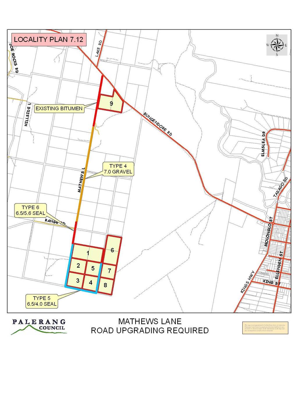
37 P 7.11 Woolshed (Added as part of Amendment No. 5) P Area Served Future developments that may occur along the 1.45 km length of Woolshed Lane from the Macs Reef Road end. P Expected Lot Yield 14 extra lots. P Road Upgrading Required The current standard of the gravel road along Woolshed Lane has been satisfactory for the level of developments to date; apart from the sub-standard intersection at Macs Reef Road end. Upgrading over time to appropriately provide for the future developments will require the following works: a. upgrading to type 4 road over 1.45 $140,000 / km at eastern end $203,000 b. upgrading to Type 3 Road over 0.75 $40,000 / km at western end $30,000 c. Macs Reef Road intersection to be upgraded to a AUR / BAL intersection $25, Section 94 Contributions a. For Woolshed Lane upgrading including intersection treatment: 258, lots = $18,430 / lot b. Towards access roads leading to Woolshed Lane (see Section 7.5 of S94 Plan) TOTAL SECTION 94 RATE REQUIRED $5,290 / lot $23,720 / lot (NOTE: These rates have been calculated at March 1994 prices and will be subject to an annual adjustment in accordance with sub clause P ) P 7.12 P Mathews Lane Area Served Future developments that may occur along Mathews Lane south of Bungendore Showground. P Expected Lot Yield Eight (8) extra residences on vacant holdings each equivalent to a lot in a new subdivision. P Road Upgrading Required The current standard of the gravel road along Mathews Lane has been satisfactory for the level of developments to date. Upgrading over time to appropriately provide for the future developments will require the following works which will need to be paid for by the new developments: Page 37
38 Section (Refer to attached locality plan 7.12) End of bitumen at showground to 60m north of Range Road From 60m north of Range Road to past Shelley residences From past Shelleys to end Length Road Type Required Estimated Costs (at October 2007) Estimated Costs (Backdated to March 1994) 1350m Type 4 gravel $76,000 $47, m 1450m Type 6 sealed 5.6m wide $46,000 $28,460 Type 5 sealed $210,000 $129,910 4m wide Total $332,000 $205, Section 94 Contributions (at March 1994 costs) a. For Mathews Lane upgrading: 205,385 8 equivalent lots = $25,673/ equiv lot (This component applies to the 8 vacant 1995 holdings south of Range Road) b. Towards access roads leading to Mathews Lane (see Section 7.5 of S94 Plan) (This component applies to all vacant 1995 holdings) TOTAL SECTION 94 RATE REQUIRED $3,551/equiv lot $29,224/equiv lot (NOTE: These rates have been calculated at March 1994 prices (the base year of the Plan) and will be subject to annual adjustments from that year in accordance with sub clause P ) Page 38
39 Page 39
Background paper (Local Government Act 1972 Section 100D)
") ITEM 13 APPLICATION NO. 12/01822/VARS APPLICATION TYPE VARIATION OF CONDITIONS - SOUTH REGISTERED 24.08.2012 APPLICANT Brook Enterprises Ltd SITE Dunwood Manor Golf Club, Danes Road, Awbridge, AWBRIDGE
ITEM 13 APPLICATION NO. 12/01822/VARS APPLICATION TYPE VARIATION OF CONDITIONS - SOUTH REGISTERED 24.08.2012 APPLICANT Brook Enterprises Ltd SITE Dunwood Manor Golf Club, Danes Road, Awbridge, AWBRIDGE
CITY OF VAUGHAN EXTRACT FROM COUNCIL MEETING MINUTES OF OCTOBER 30, 2012
 CITY OF VAUGHAN EXTRACT FROM COUNCIL MEETING MINUTES OF OCTOBER 30, 2012 Item 31, Report No. 39, of the Committee of the Whole, which was adopted without amendment by the Council of the City of Vaughan
PROPOSED RESIDENTIAL SUBDIVISION
 PROPOSED RESIDENTIAL SUBDIVISION PART OF TARNEIT ROAD & 1121 DOHERTYS ROAD, TARNEIT Prepared For: TCG (RM) Developments Pty Ltd MARCH 2014 OUR REF: 16740R#1 PROPOSED RESIDENTIAL SUBDIVISION PART OF TARNEIT
Planning for tennis in your Local Government Area. A resource from Tennis Australia
 Planning for tennis in your Local Government Area A resource from Tennis Australia Part 1 July 2016 ABOUT THIS RESOURCE This resource forms part of Tennis Australia's Local Government Engagement Program.
Transit boulevard: A new road type for Sydney s Growth Centres
 Transit boulevard: A new road type for Sydney s Growth Centres Cleaver, M. A., de Roos, M. P., NSW Centre for Road Safety, Roads and Traffic Authority, NSW Collins, G., Network Services, Roads and Traffic
Appendix 12 Parking on footways and verges
 Appendix 12 Parking on footways and verges Legal position Parking on footways and verges whether wholly or partly is banned throughout London, unless signs are placed to allow parking. The ban requires
Active Transportation Infrastructure Investment A Business Case
 Active Transportation Infrastructure Investment A Business Case In 2016, the Real Estate Foundation awarded the Capital Regional District a $50,000 grant for Shifting Gears: Land Use Change through Active
RANDWICK CITY COUNCIL Residential Discussion Paper SUMMARY DOCUMENT
 RANDWICK CITY COUNCIL Residential Discussion Paper SUMMARY DOCUMENT Residential Discussion Paper Summary Sheet Background Randwick City Council is reviewing our local planning and development controls
March Maidstone Integrated Transport Strategy Boxley Parish Council Briefing Note. Context. Author: Parish Clerk 2 March 2016
 Context. Author: Parish Clerk 2 The Draft Integrated Transport Policy (DITS) sets out a vision and objectives, and identifies a detailed programme of interventions to support the Maidstone Borough Local
1. THE IMPACT OF HEAVY VEHICLE TRAFFIC ON ROAD PAVEMENTS
 1. THE IMPACT OF HEAVY VEHICLE TRAFFIC ON ROAD PAVEMENTS 1.1 Background The road network in NZ compromises approximately 95,100 km of roads. About 12.5 % or 11,900 km of these roads are State Highways
Seal Extension Guidelines. Asset Management and Systems
 Seal Extension Guidelines 1. Guideline Definitions AADT - Annual Average Daily Traffic is measured at regular annual (or greater) intervals and adjusted for seasonal effects, using an approved traffic
TRANSPORT PUBLIC SAFETY SERVICES THAT SUPPORT COMMUNITIES. Provide access to, from and for emergency services
 Transport - 128 - Road Network KEY FACTS Council operates and maintains a network of some 2,53 km which includes: o 864 km of sealed roads o 1,666 km of unsealed roads o 7 bridges and large culverts o
IMPLEMENTATION GUIDELINE NO. 13
 IMPLEMENTATION GUIDELINE NO. 13 Provision of Electricity, Driveways and Crossovers, Footpaths, Kerb and Channel Date of Council Resolution These guidelines were adopted by Council on 13 October 2009, and
land transport road assets
 land transport road assets land transport road assets Otago Region Information as at June 2007 land transport road assets 2 Purpose of this publication Land Transport New Zealand annually publishes comparative
Chapter 5 FUNCTIONAL CLASSIFICATION
 Chapter 5 FUNCTIONAL CLASSIFICATION Functional classification is a system by which streets and roadways may be distinguished by types according to their function within the entire transportation network.
WANAKA SWIMMING FACILITIES STATEMENT OF PROPOSAL
 WANAKA SWIMMING FACILITIES STATEMENT OF PROPOSAL 17 October 2014 Contents Executive Summary Background National Guidelines The Status Quo Issue One Timing Issue Two Location Issue Three Size Issue Four
TOWN OF CHAPEL HILL POLICY AND PROCEDURES FOR TRAFFIC CALMING MEASURES
 TOWN OF CHAPEL HILL POLICY AND PROCEDURES FOR TRAFFIC CALMING MEASURES (Adopted by the Town Council on June 30, 2004) (Revised December 6, 2010) (Revised February 8, 2016) POLICY AND PROCEDURES FOR TRAFFIC
Department of Internal Affairs Mandatory Non-Financial Performance Measures 2013 Roads and Footpaths
 Road Asset Technical Accord - RATA The Centre of Excellence for Road Asset Planning in the Waikato Region Department of Internal Affairs Mandatory Non-Financial Performance Measures 2013 Roads and Footpaths
1.3.4 CHARACTERISTICS OF CLASSIFICATIONS
 Geometric Design Guide for Canadian Roads 1.3.4 CHARACTERISTICS OF CLASSIFICATIONS The principal characteristics of each of the six groups of road classifications are described by the following figure
APPELLANT S STATEMENT OF CASE
 TOWN & COUNTRY PLANNING ACT 1990 (AS AMENDED) APPEAL BY FOCUS INTERNATIONAL CHRISTIAN CENTRE (FICC) AGAINST REFUSAL OF PLANNING PERMISSION BY THE LONDON BOROUGH OF HILLINGDON PLANNING PERMISSION IS SOUGHT
Response to further information request Ministry of Education Notice of Requirement (200 & 252 Park Estate Road)
") 21 Pitt Street PO Box 6345, Auckland 1141, New Zealand T: +64 9 300 9000 // F: +64 9 300 9300 E: info@beca.com // www.beca.com Auckland Council Private Bag 92300 Victoria Street West Auckland 1142 15 August
21 Pitt Street PO Box 6345, Auckland 1141, New Zealand T: +64 9 300 9000 // F: +64 9 300 9300 E: info@beca.com // www.beca.com Auckland Council Private Bag 92300 Victoria Street West Auckland 1142 15 August
1 VicRoads Access Management Policies May 2006 Ver VicRoads Access Management Policies May 2006 Version 1.02
 1 VicRoads Access Management Policies May 2006 Ver 1.02 VicRoads Access Management Policies May 2006 Version 1.02 2 VicRoads Access Management Policies May 2006 Ver 1.02 FOREWORD FOR ACCESS MANAGEMENT
TRAFFIC IMPACT STUDY CRITERIA
 Chapter 6 - TRAFFIC IMPACT STUDY CRITERIA 6.1 GENERAL PROVISIONS 6.1.1. Purpose: The purpose of this document is to outline a standard format for preparing a traffic impact study in the City of Steamboat
land transport road assets
 land transport road assets land transport road assets Westland District West Coast Region Information as at June 2006 land transport road assets 2 Purpose of this publication Land Transport New Zealand
Transportation Master Plan Advisory Task Force
 Transportation Master Plan Advisory Task Force Network Alternatives & Phasing Strategy February 2016 BACKGROUND Table of Contents BACKGROUND Purpose & Introduction 2 Linking the TMP to Key Council Approved
DESIGN CODE. Enterprise West Harlow London Road North Design Code 21
 DESIGN CODE Enterprise West Essex @ Harlow London Road North Design Code 21 4 MAXIMUM BUILDING HEIGHTS 4.1 Table 4A sets out maximum building height standards for each character area within the LDO boundary.
9. Parking Supporting Statement
 9. Parking Supporting Statement Content 1. Setting the Scene 2. Vision 3. Parking and the Shared Priorities 4. Issues 5. Delivery Programme in the first Plan Period 2001/02 2005/06 6. Good Practice 7.
Devonport City Cycling Network Strategy
 Devonport City Cycling Network Strategy 2010-2013 Devonport City Cycling Network Strategy Introduction In February 2010 a draft master plan for cycleways was presented to the community. The feedback received
EXECUTIVE SUMMARY Callan Park accommodates travel from a wide range of transport modes, including walking, cycling, bus and light rail.
 TRANSPORT AND ACCESS EXECUTIVE SUMMARY Callan Park accommodates travel from a wide range of transport modes, including walking, cycling, bus and light rail. Whilst there are some walking facilities within
A5.1 Permitted activities
 Section A5 Transportation A5.1 Permitted activities A5.1.1 Activities within roads Note: Refer to Section D for the definition of road (a) Any activity associated with the movement of traffic and the functioning
City of Perth Cycle Plan 2029
 Bicycling Western Australia s response City of Perth Cycle Plan 2029 2012-2021 More People Cycling More Often ABOUT BICYCLING WESTERN AUSTRALIA Bicycling Western Australia is a community based, not-for-profit
Traffic Calming Policy
 Article I. Purpose and Goal. The purpose of this policy is to establish criteria and procedures the City will use to evaluate requests for, and if appropriate, implement traffic calming measures. Neighborhood
PALERANG DEVELOPMENT CONTROL PLAN FENCING REQUIREMENTS IN RURAL, ENVIRONMENTAL PROTECTION AND RURAL RESIDENTIAL AREAS
 PALERANG DEVELOPMENT CONTROL PLAN FENCING REQUIREMENTS IN RURAL, ENVIRONMENTAL PROTECTION AND RURAL RESIDENTIAL AREAS Palerang Council PO Box 348 Bungendore NSW 2621 Phone: 02 6238 8111 Approved by Council:
ANNUAL RELIABILITY AND POWER QUALITY REPORT for the year ended 30 June 2017
 ELECTRICITY INDUSTRY (NETWORK QUALITY AND RELIABILITY OF SUPPLY) CODE 2005 ANNUAL RELIABILITY AND POWER QUALITY REPORT for the year ended 30 June 2017 SEPTEMBER 2017 Page 1 of 81 Contents 1 Purpose...
SECTION 1 - TRAFFIC PLANNING
 SECTION 1 - TRAFFIC PLANNING 1.1 TRAFFIC OPERATIONS 1.1.1 Roadway Functional Classification The Multnomah County Comprehensive Framework Plan s Policy 34: Trafficways and the Functional Classification
City of Wayzata Comprehensive Plan 2030 Transportation Chapter: Appendix A
 A1. Functional Classification Table A-1 illustrates the Metropolitan Council s detailed criteria established for the functional classification of roadways within the Twin Cities Metropolitan Area. Table
REMOVE BARRIERS TO, ENCOURAGE CREATION OF AND PROVIDE GUIDELINES FOR SAFE ROUTES (ALL DISTRICTS)
") Ordinance 2009-98 AN ORDINANCE OF THE BOARD OF SUPERVISORS OF PIMA COUNTY, ARIZONA; RELATING TO ZONING; AMENDING THE PIMA COUNTY ZONING CODE TITLE 18 BY AMENDING SECTION 18.03.020 (DEFINITIONS) TO ADD
Ordinance 2009-98 AN ORDINANCE OF THE BOARD OF SUPERVISORS OF PIMA COUNTY, ARIZONA; RELATING TO ZONING; AMENDING THE PIMA COUNTY ZONING CODE TITLE 18 BY AMENDING SECTION 18.03.020 (DEFINITIONS) TO ADD
New Measure A Expenditure Categories DEFINITIONS OF ELIGIBLE EXPENDITURES Adopted March 8, 2007
 New Measure A Expenditure Categories DEFINITIONS OF ELIGIBLE EXPENDITURES Adopted March 8, 2007 City Street and County Road Maintenance Program The preservation and keeping of public street and road rights-of-way
Speed Limit Policy Isle of Wight Council
 APPENDIX B Speed Limit Policy Isle of Wight Council 2009 Contents Section 1 Introduction 1.1 Links with the Local Transport Plan Section 2 Speed Limits on Urban Roads and Residential Areas 2.1 20mph Limits
Recommended Roadway Plan Section 2 - Land Development and Roadway Access
 Recommended Roadway Plan Section 2 - Land Development and Roadway Access SECTION 2 Land Development and Roadway Access 2.1 Land Use and Access Management The Federal Highway Administration (FHWA) defines
DRAFT for a State Policy for Healthy Spaces and Places
 DRAFT for a State Policy for Healthy Spaces and Places 1 DRAFT State Policy for Healthy spaces and Places 1. Purpose To encourage the use and development of land that builds healthy communities through
DEVELOPMENT OF A PAVEMENT REHABILITATION STRATEGY FOR NATIONAL ROADS IN QUEENSLAND
 DEVELOPMENT OF A PAVEMENT REHABILITATION STRATEGY FOR NATIONAL ROADS IN QUEENSLAND Presenter: Tyrone Toole, ARRB Group Scope Background Objectives Road network data and analysis Current and potential investment
Report to COUNCIL for decision
 17 152 Title: Section: Prepared by: Olympic Pool Business Case Community & Recreation Andrew White (Community & Recreation Manager) Meeting Date: 18 May 2017 Legal Financial Significance = Medium Report
Wicklow County Council Chomairle Chontae Chill Mhantáin. Traffic Calming Policy
 Chomairle Chontae Chill Mhantáin Adopted by Wicklow County Council on the 11th of June, 2012 Contents Section Page 1. Introduction 3 2. Legislation 3 3. Guidance Documentation 3 4. Policy Objectives &
DESIGN BULLETIN #66/2010
 DESIGN BULLETIN #66/2010 Highway Geometric Design Guide Chapter B, Climbing Lane Warrants for Two Lane Undivided and Four Lane Divided Highways - Revised Summary This Design Bulletin is being issued as
1.5 On this basis it is fundamental that the Transport Strategy for the site focuses on the following key criteria,
 1.0 Introduction 1.1 The Transport Assessment has been prepared on behalf of Eon and Roger Bullivant Ltd in respect of the proposed mixed use sustainable urban extension of Drakelow Park. 1.2 The methodology
SCHEME DESIGN AND ENGINEERING
 THE NORTH SOMERSET COUNCIL (SOUTH BRISTOL LINK CLASSIFIED ROAD) SIDE ROADS ORDER 2013 THE NORTH SOMERSET COUNCIL (SOUTH BRISTOL LINK) COMPULSORY PURCHASE ORDER 2013 THE NORTH SOMERSET COUNCIL (SOUTH BRISTOL
Clackamas County Comprehensive Plan
 ROADWAYS The County s road system permits the movement of goods and people between communities and regions, using any of a variety of modes of travel. Roads provide access to virtually all property. They
TECHNICAL NOTE THROUGH KERBSIDE LANE UTILISATION AT SIGNALISED INTERSECTIONS
 TECHNICAL NOTE THROUGH KERBSIDE LANE UTILISATION AT SIGNALISED INTERSECTIONS Authors: Randhir Karma NDip: Eng (Civil) B. Tech Eng (Civil) M Eng (Hons) (Transportation) Auckland Traffic Service Group Manager
RESOLUTION NO ?? A RESOLUTION OF THE CITY OF NEPTUNE BEACH ADOPTING A COMPLETE STREETS POLICY
 RESOLUTION NO. 2018-?? A RESOLUTION OF THE CITY OF NEPTUNE BEACH ADOPTING A COMPLETE STREETS POLICY WHEREAS, safe, convenient, and accessible transportation for all users is a priority of the City of Neptune
City of Homewood Transportation Plan
 City of Homewood Transportation Plan Prepared for: City of Homewood, Alabama Prepared by: Skipper Consulting, Inc. May 2007 TABLE OF CONTENTS INTRODUCTION... 1 BACKGROUND INFORMATION... 1 EXISTING TRANSPORTATION
Summary of Proposal to Upgrade Swimming Facilities for the Wanaka Ward
 Attachment B Summary of Proposal to Upgrade Swimming Facilities for the Wanaka Ward Introduction The Queenstown Lakes District Council is proposing to build an eight lane lap pool and a learners pool costing
US 19 Pedestrian and Bicycle Safe Access to Transit Corridor Study
 US 19 Pedestrian and Bicycle Safe Access to Transit Corridor Study DRAFT Technical Memorandum #6 Cost and Benefit Evaluation Methodology August 2016 Prepared for: FLORIDA DEPARTMENT OF TRANSPORTATION DISTRICT
Exhibit 1 PLANNING COMMISSION AGENDA ITEM
 Exhibit 1 PLANNING COMMISSION AGENDA ITEM Project Name: Grand Junction Circulation Plan Grand Junction Complete Streets Policy Applicant: City of Grand Junction Representative: David Thornton Address:
The Joint Report of the Bus Lane Adjudicators
 The Joint Report of the Bus Lane Adjudicators January 2007 March 2008 1 For the period covered by this report only a few councils were undertaking civil bus lane enforcement so that there are a relatively
Secondary Road Program
 Secondary Road Program Joint Legislative Transportation Oversight Committee October 5, 2012 1 Secondary Roads Program The Big Picture The Secondary Road System Needs and Project Types Paved and Unpaved
Section 2 Strategic Alignment. Contents
 Section 2 Strategic Alignment Contents 2 Strategic Alignment... 2 2.1 General... 2 2.2 SmartGrowth Strategy and Implementation Plan... 2 2.3 Walking and Cycling Strategy... 3 2.4 Built Environment Strategy...
IMPLEMENTATION STRATEGIES
 GEORGETOWN SIDEWALK MASTER PLAN 34% of funding is dedicated to Downtown Overlay District sidewalks 28% of funding is recommended within 1/4 mile of Southwestern University 26% of funding is recommended
CITY OF LUCAS 2014 MASTER THOROUGHFARE PLAN
 INTRODUCTION CITY OF LUCAS 2014 MASTER THOROUGHFARE PLAN A thoroughfare system is intended to provide an effective means of moving vehicles within and through a city. The thoroughfare plan will assist
This Chapter sets forth the minimum design, technical criteria and specifications to be used in the preparation of all roadway plans.
 4.1 GENERAL This Chapter sets forth the minimum design, technical criteria and specifications to be used in the preparation of all roadway plans. These Roadway Standards are for new construction and modification
Barwon Heads Road, Armstrong Creek Traffic Impact Assessment Prepared for: Newland Developers Pty Ltd
 892 990 Barwon Heads Road, Armstrong Creek Traffic Impact Assessment Prepared for: Newland Developers Pty Ltd JULY 2015 TABLE OF CONTENTS 1 INTRODUCTION... 1 1.1 BACKGROUND... 1 1.2 SCOPE... 1 1.3 AIM
Access Management Standards
 Access Management Standards Section 1: Application of Access Standards This chapter describes the Department's access management standards for access connections on the county roadway system. The standards
Additional Policies & Objectives for Local Area Plans Ashbourne LAP. Ashbourne
 Ashbourne Strategic Policies SP 1 To operate an Order of Priority for the release of residential lands in compliance with the requirements of CS OBJ 6 of the County Development Plan as follows: i) The
Roadway Classification Design Standards and Policies. Pueblo, Colorado November, 2004
 Roadway Classification Design Standards and Policies Pueblo, Colorado November, 2004 Table of Contents Page Chapter 1. General Provisions 1.1 Jurisdiction 3 1.2 Purpose and Intent 3 1.3 Modification 3
WYDOT DESIGN GUIDES. Guide for. Non-NHS State Highways
 WYDOT DESIGN GUIDES Guide for Non-NHS State Highways 2014 GUIDE FOR Non-NATIONAL HIGHWAY SYSTEM (Non-NHS) STATE HIGHWAYS PRESERVATION REHABILITATION RECONSTRUCTION INTRODUCTION This Guide is directed to
Australian Standard. Manual of uniform traffic control devices. Part 3: Traffic control for works on roads AS AS 1742.
 AS 1742.3 2009 AS 1742.3 2009 Australian Standard Manual of uniform traffic control devices Part 3: Traffic control for works on roads This Australian Standard was prepared by Committee MS-012, Road Signs
Traffic and Transport Assessment
 Traffic and Transport Assessment Section 96 Residential Subdivision, Davis Road Tarneit CG120370 Prepared for Stockland Pty Ltd 19 February 2013 Document Information Prepared for Stockland Pty Ltd Project
ABERDEEN: CITY OF THE FUTURE
 ABERDEEN: CITY OF THE FUTURE A contribution towards discussions on a future transport strategy for Aberdeen and its Region Prepared by the Centre for Transport Research University of Aberdeen June 2010
BLYTHEWOOD PARK, BROMLEY
 BLYTHEWOOD PARK, BROMLEY Proposed Access Junction to Serve a Single Residential Dwelling On behalf of Robert Pooke CONTENTS Introduction...1 Appeal Site and Planning History...2 Relevant Transport Policy...4
CHAPTER 7 ACCESS MANAGEMENT. Background. Principles of Access Management. Hennepin County Transportation Systems Plan (HC-TSP)
") CHAPTER 7 ACCESS MANAGEMENT Background Principles of Access Management Hennepin County Transportation Systems Plan (HC-TSP) Chapter 7 Access Management 7.1 Background Access management has become an important
CHAPTER 7 ACCESS MANAGEMENT Background Principles of Access Management Hennepin County Transportation Systems Plan (HC-TSP) Chapter 7 Access Management 7.1 Background Access management has become an important
Cabinet Member for Highways & Streetscene. Highway Infrastructure Manager
 LONDON BOROUGH OF RICHMOND UPON THAMES DATE: AUGUST 2015 DECISION MAKER: LEAD OFFICER: SUBJECT: WARDS: Cabinet Member for Highways & Streetscene Highway Infrastructure Manager PROPOSED CYCLING IMPROVEMENTS
TRANSPORT AND MOVEMENT
 TRANSPORT AND MOVEMENT Movement Strategy Public Transport Cycling and Walking Road Network Parking Standards Transport Impact Assessments Traffic Management Policies DRAFT POOLBEG PLANNING SCHEME Movement
Truck Climbing Lane Traffic Justification Report
 ROUTE 7 (HARRY BYRD HIGHWAY) WESTBOUND FROM WEST MARKET STREET TO ROUTE 9 (CHARLES TOWN PIKE) Truck Climbing Lane Traffic Justification Report Project No. 6007-053-133, P 101 Ι UPC No. 58599 Prepared by:
Strategy for Walking & Cycling Action Plan
 Strategy for Walking & Cycling Action Plan To achieve higher levels of walking and cycling activity, the destinations which people access have to be available within suitable distances and designed to
POLICY: TRAFFIC CALMING
 2006 MAY REFERENCE: COUNCIL APPROVED BY COUNCIL MAY 23, 2006 CITY OPERATIONS - NO. 608 POLICY: TRAFFIC CALMING A. All requests for traffic calming within the City shall be considered in accordance with
Transportation Element
 The paradox of transportation in the late 20 th Century is that while it became possible to travel to the moon, it also became impossible, in many cases, to walk across the street. Joell Vanderwagen Vision:
Classification Criteria
 SCHEDULE D TO RECOMMENDED OFFICIAL PLAN AMENDMENT NO. 40 SCHEDULE C-4 Road Criteria Criteria Traffic Service Objective Land Service/Access Typical Daily Traffic Volume Flow characteristics Travel Speed
10 SHERFORD Town Code
 Key Fixes (Ref: Masterplan Book, section 4a. Land Use Budget and Key Fixes ) The Town Plan designs and allocates buildings, streets and spaces as accurately as possible in the understandable absence of
Pedestrian Level Crossings Design and Installation
 Discipline: Engineering (Track & Civil) Category: Standard Pedestrian Level Crossings Design and Installation ETD-16-03 Applicability New South Wales CRIA (NSW CRN) Primary Source ARTC NSW Standard XDS
Chapter 3 DESIGN SPECIFICATIONS
 Brampton PathWays Planning and Design Guidelines 27 Chapter 3 DESIGN SPECIFICATIONS 3.1 CLASS 1 MULTI-USE PATH Off-road multi-use trails are the backbone of the Brampton PathWays Network. They are typically
CITY OF BLOOMINGTON COMPLETE STREETS POLICY
 CITY OF BLOOMINGTON COMPLETE STREETS POLICY POLICY OBJECTIVE: The City of Bloomington will enhance safety, mobility, accessibility and convenience for transportation network users of all ages and abilities,
Crash Patterns in Western Australia. Kidd B., Main Roads Western Australia Willett P., Traffic Research Services
 Crash Patterns in Western Australia Kidd B., Main Roads Western Australia Willett P., Traffic Research Services Abstract Examination of crash patterns is one way of identifying key factors on which focus
Optimising Gravel Road Maintenance Strategies. Presenter: Gerrie van Zyl
 Optimising Gravel Road Maintenance Strategies Presenter: Gerrie van Zyl Scope Introduction Road management systems Utilising information to improve maintenance strategies Blading optimisation process Conclusion
PREDICTING TEXTURE DEFICIENCY IN PAVEMENT MANAGEMENT PREDICTING TEXTURE DEFICIENCY IN PAVEMENT MANAGEMENT
 PREDICTING TEXTURE DEFICIENCY IN PAVEMENT MANAGEMENT Sean Rainsford Chris Parkman MWH NZ Ltd Transit New Zealand PREDICTING TEXTURE DEFICIENCY IN PAVEMENT MANAGEMENT Inadequate texture is one of the key
GOVERNMENT OF SASKATCHEWAN SUBMISSION TO THE RAILWAY SAFETY ACT REVIEW PANEL
 GOVERNMENT OF SASKATCHEWAN SUBMISSION TO THE RAILWAY SAFETY ACT REVIEW PANEL Saskatchewan Highways & Transportation May 29, 2007 I Introduction Government of Saskatchewan Submission To the Railway Safety
WYDOT DESIGN GUIDES. Guide for. NHS Arterial (Non-Interstate)
") WYDOT DESIGN GUIDES Guide for NHS Arterial (Non-Interstate) 2014 GUIDE FOR NATIONAL HIGHWAY SYSTEM (NHS) HIGHWAYS (NHS ARTERIALS, Non-Interstate) PRESERVATION REHABILITATION RECONSTRUCTION INTRODUCTION
WYDOT DESIGN GUIDES Guide for NHS Arterial (Non-Interstate) 2014 GUIDE FOR NATIONAL HIGHWAY SYSTEM (NHS) HIGHWAYS (NHS ARTERIALS, Non-Interstate) PRESERVATION REHABILITATION RECONSTRUCTION INTRODUCTION
Access requests to County streets and roadways are processed through one of the following methods:
 13.1 GENERAL APPLICATION PROCESS Access requests to County streets and roadways are processed through one of the following methods: A. Planned Developments may set general locations for access points.
COUNCIL POLICY NAME: COUNCIL REFERENCE: 06/119 06/377 09/1C 10llC 12/1C INDEX REFERENCE: POLICY BACKGROUND
 COUNCIL POLICY NAME: COUNCIL ADVISORY COMMITTEES - TERMS OF REFERENCE ISSUED: APRIL 3, 2006 AMENDED: NOVEMBER 27, 2006 NOVEMBER 23, 2009 JANUARY 11, 2010 DECEMBER 17, 2012 POLICY COUNCIL REFERENCE: 06/119
TRAFF IC CALMING POLICY
 TRAFF IC CALMING POLICY Policy No: 45396 Approved by Council 28 May 2008 C11/05/08 Further amendment by Council 22 June 2011 vide c08/06/11 Contents 1 Problem Statement 1 2 Desired Outcomes 2 3 Strategic
INTRODUCTION THOROUGHFARE SYSTEM CLASSIFICATIONS
 INTRODUCTION The thoroughfare plan will assist public officials in the development of a specialized system for efficient and safe movement of vehicular traffic while minimizing potential conflicts with
Amendments to Essex Highway Maintenance Strategy Maintenance Policy and Standards April 2008
 Amendments to Essex Highway Maintenance Strategy Maintenance Policy and Standards April 2008 The following amendments to the wording of the maintenance strategy apply following the revised maintenance
MICROPHONE WIND SPEED LIMITS DURING WIND FARM NOISE MEASUREMENTS
 MICROPHONE WIND SPEED LIMITS DURING WIND FARM NOISE MEASUREMENTS Abstract Jon Cooper 1 and Tom Evans 2 1 Resonate Acoustics, Level 1/23 Peel St, Adelaide SA 5000, Australia Email: jon.cooper@resonateacoustics.com
Traffic Impact Study. Westlake Elementary School Westlake, Ohio. TMS Engineers, Inc. June 5, 2017
 TMS Engineers, Inc. Traffic Impact Study Westlake Elementary School Westlake, Ohio June 5, 2017 Prepared for: Westlake City Schools - Board of Education 27200 Hilliard Boulevard Westlake, OH 44145 TRAFFIC
Pavement Management Report. City Council Meeting of May 21, 2013
 Pavement Management Report City Council Meeting of May 21, 2013 Previous Meetings Summary In February, we presented the 2012 pavement survey and our consultant presented general pavement management strategies
To: The results of these surveys have been analysed and are summarised within this Technical Note.
 Technical Note Project: Histon Road / Milton Road, Cambridge Parking Surveys To: Andy Harrison Subject: Survey Report v1.6 From: Jonathan Barlow Date: 18 th February 2016 cc: Richard Jones / Dave Boddy
Footpath design. A guide to creating footpaths that are safe, comfortable, and easy to use
 Footpath design A guide to creating footpaths that are safe, comfortable, and easy to use November 2013 Contents Introduction / 1 Zoning system / 2 Width / 4 Height / 5 Surface / 5 Footpath elements /
Your views are important. Please fill in a form before you leave. Or alternatively
 Drum Property Group is delighted to welcome you to this exhibition which sets out our initial proposals for a mixed-use development at Stead s Place, Edinburgh. We are keen to hear the views of local people
Road Condition Statistics: Notes and definitions
 Road Condition Statistics: Notes and definitions This note provides definitions used for road condition statistics. It also includes useful information on the source of the data 1. Source The statistics
Warfield Neighbourhood Plan: 4.4 Infrastructure
 Warfield Neighbourhood Plan: 4.4 Infrastructure Previously decided Policy headings: Policy WNP16 Transport Impact of Development Policy WNP17 Transport Proposals Policy WNP18 New School Buildings Policy
Regional Transportation Needs Within Southeastern Wisconsin
 Regional Transportation Needs Within Southeastern Wisconsin #118274 May 24, 2006 1 Introduction The Southeastern Wisconsin Regional Planning Commission (SEWRPC) is the official areawide planning agency