EUCLID AVENUE PARKING STUDY CITY OF SYRACUSE, ONONDAGA COUNTY, NEW YORK
|
|
|
- George James
- 5 years ago
- Views:
Transcription

1 EUCLID AVENUE PARKING STUDY CITY OF SYRACUSE, ONONDAGA COUNTY, NEW YORK CITY OF SYRACUSE DEPARTMENT OF PUBLIC WORKS 1200 CANAL STREET EXTENSION SYRACUSE, NEW YORK DRAFT REPORT DATE: November 13, Harrison Street // Suite 210 // Syracuse, NY 13202
2 Table of Contents I. Introduction... 1 II. Existing Conditions... 2 A. Parking Regulations and Corridor Attributes... 2 B. Concerns... 2 C. Bicycles... 2 D. Existing Parking Utilization... 3 III. Analysis of Alternatives IV. Recommendations i
3 List of Tables Table 1 Table 2 Table 3 Table Existing Bicycle Volumes..... Existing Parking Utilization Saturday July 26 th over Entire Corridor Existing Parking Utilization Tuesday July 29 th over Entire Corridor Existing Parking Utilization Thursday September 18 th over Entire Corridor List of Figures Figure 1 Figure 2 Figure 3 Figure Corridor Location Map....Existing Parking Saturday July 26 th over Entire Corridor.Existing Parking Tuesday July 29 th over Entire Corridor...Existing Parking Thursday September 18 th over Entire Corridor List of Appendices Appendix A Concept Plans for Alternatives 1 and 2 ii

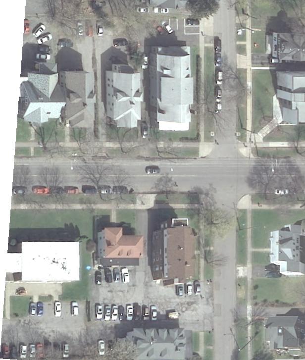
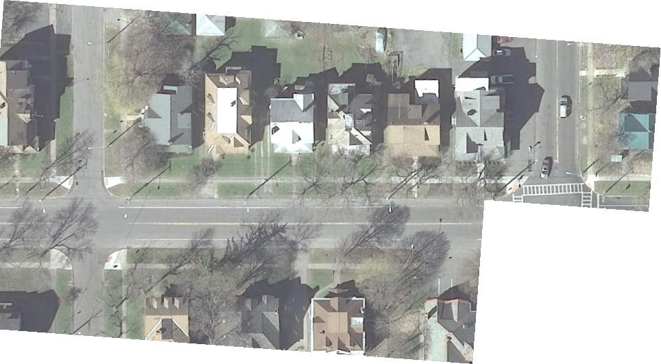
4 I. Introduction The purpose of this study is to analyze parking conditions along the Euclid Avenue corridor between Westcott Street and Ostrom Avenue. Figure 1 is a Corridor Location Map. The goal is to study the impacts of adding bike facilities along the corridor since Euclid Avenue is a highly-utilized route for cyclists. The main competing concerns are for heavy vehicle, bike and parking use. This study will analyze the impacts of two alternatives for the cross-section including 1) removing parking on Euclid Avenue to provide exclusive bike lanes with buffer zones for the safety of cyclists and 2) narrowing vehicle lanes to provide one lane of floating parking and a cycle track on the south side of the street. Figure 1 Corridor Location Map PAGE 1
5 II. Existing Conditions A. Parking Regulations and Corridor Attributes The current parking regulations on Euclid Avenue are alternate one-side parking, commonly referred to as even/odd day parking between Westcott Street and Ostrom Avenue. Parking is allowed on the north side from 6pm odd days to 6pm even days and on the south side from 6pm even days to 6pm odd days. Parking is not allowed near intersection corners for the length of the study area on Euclid Avenue. Bus stops are located within these areas where parking is prohibited. The width of Euclid Avenue varies from 39 to 39 ½ feet. There is one lane in each direction with parking on both sides of the street in accordance with the restriction described above. The posted speed limit is 30 mph. B. Concerns Occupation of daytime on-street parking by University employees and commuting students along Euclid Avenue yet off-street parking is available for their needs. There is a noted demand for dedicated or shared-use bike lanes, however, there are no current striped lanes available. Not all residences along the corridor have off-street parking. Currently, apparent demand for residential parking is met by on-street spaces on Euclid Avenue and adjacent side streets. Side street parking appears to be near capacity during the weekday daytime hours and has little additional parking capacity available. Snow removal activities require parking time-of-day restrictions. Daytime parking restrictions would facilitate snow removal while ensuring overnight parking availability for adjacent residents. C. Bicycles Bicyclists were counted along the corridor during the same time periods as the parking counts were taken to determine the current level of bike facility demand. Counts were conducted on Saturday, July 26th at 9AM, 3PM, and 9PM. Weekday counts were conducted at 6AM, 9AM, 12PM, 3PM, 6PM and 9PM on Tuesday, July 29 th and Thursday, September 18th. Fewer time periods were required on Saturday for the parking analysis due to the reduction in demand as compared to parking during weekdays. Therefore, the time periods chosen were spread-out over the day with less frequency, and focused on the later time periods due to expected peaking PAGE 2
6 during a typical weekend day. In general, less parking activity occurs during the early morning on a weekday. In general, these parking study time periods also work well for conducting bicycle counts as the volume of bicyclists is distributed throughout the day during the weekend and during the weekday a greater number of time periods is required to obtain a clear indication of the peaking characteristics of bikes as volumes are much higher during the week. A summary of the bike count volumes follows. Table 1 shows a summary of the bicycle volumes counted concurrent with the parking study. TABLE 1 - Existing Bicycle Volume Two-Way Bicycle Traffic Time Period Column #1 Saturday July 26, 2014 Date of Counts Column #2 Tuesday July 29, 2014 Column #3 Thursday September 18, :30 am - 6:30 am No Data Required 6 4 8:30 am - 9:30 am :30 am - 12:30 pm No Data Required :30 pm -3:30 pm :30 pm - 6:30 pm No Data Required :30 pm - 9:30 pm The bicycle volumes during the summer months (Note Column #1 and #2) when Syracuse University is in Summer Sessions, shows there are low volumes of bicycle users than during the Fall Session (Column #3); however, sufficient weekday Summer volumes as well as significant Fall bike volumes attest to the demand for dedicated bicycle facilities. D. Existing Parking Utilization Parking counts were conducted at regular intervals to capture the number of occupied parking spaces. Parked cars were counted during the summer of 2014 on Saturday, July 26, 2014 at 9AM, 3PM, and 9PM and Tuesday, July 29, 2014 at 6AM, 9AM, 12PM, 3PM, 6PM and 9PM. Counts were taken on a weekend day as well as during the standard business week to establish the difference in demand and provide an understanding of type of parking users to determine the seasonal and peak day of week impacts as well. Counts were also completed on Thursday, September 18, 2014 to compare summer and fall parking occupancy and demand. Similar to the July 29 count periods, the September 18 weekday counts were conducted at 6AM, 9AM, 12PM, 3PM, 6PM and 9PM. The graphs in Figures 2, 3 and 4 on the following pages show the parking utilization over the entire corridor. PAGE 3


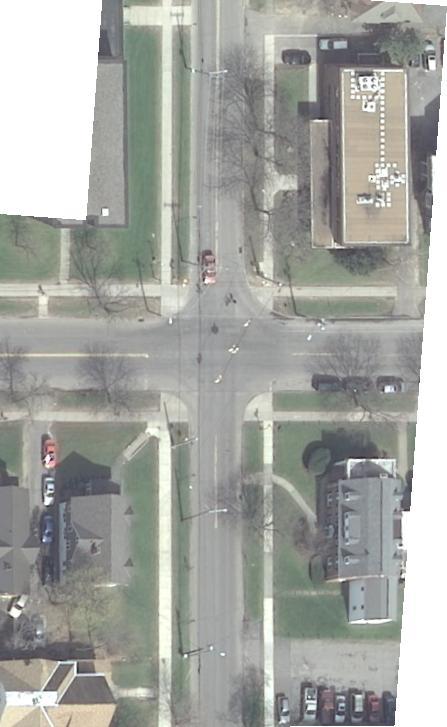
7 PHOTOGRAPH 1 View Facing West on Euclid Avenue approaching Comstock Avenue FIGURE 2 - Existing Parking Saturday July 26th over Entire Corridor PAGE 4
8 As expected the demand for parking was much greater during the summer weekday as compared to the summer Saturday, shown by comparing Figures 2 and 3. The peak demand was 52 vehicles occurring mid-day at 12PM during the weekday. Parking occupancy ranged from 12 to 17 vehicles during the Saturday and from 20 vehicles to 52 vehicles during the weekday. The change over time of 6pm is noted on Figures 2, 3 and 4. This is the generally the time when most parkers move their vehicles, often to the other side of the street. As the figures show, there were some parkers that were not compliant with the parking regulations at 9PM during the two summer days studied. There were 6 vehicles parked on the wrong side of the street at 9PM on the Saturday and 4 vehicles at 9PM on the weekday. In general parking was underutilized during the summer time periods, particularly on Saturday. FIGURE 3 - Existing Parking Tuesday July 29th over Entire Corridor During Fall Sessions parking demand was expected to be much greater than during the summer, as shown by comparing Figure 4 with Figures 2 and 3. The peak weekday demand was at capacity during the fall weekday at 64 vehicles (north side at capacity at 9AM and 3PM) as compared to 52 vehicles occurring mid-day at 12PM during the summer weekday. Parking occupancy ranged from 38 to 64 vehicles during the fall weekday and from 20 vehicles to 52 vehicles during the weekday. In general, parking occupancy was at or near capacity starting between 6AM and 9AM and ending between 3PM and 6PM. Comparing overall peak utilization for the Euclid Avenue study area from Ostrom Avenue to Westcott Street, the peak utilization is 100% during the fall weekday periods and 70%-80% during the summer weekday periods depending on even/odd day of the week (slightly above 80% when parking is allowed on the north side and slightly above 70% when parking is allowed on the south side). Due to high demand on the side streets, the utilization during fall weekdays is expected to be 100% on both odd days and even days as the parking capacity differs by only eight (8) spaces. The difference in capacity is mainly due to the number and width of driveways along this stretch of Euclid Avenue. There are 26 driveways on the north side of the street, compared to 18 on the south side PAGE 5

9 There were a greater number of vehicles parked that were not compliant with the parking regulations during the fall weekday period as compared to the summer weekday period. Both during the 3PM and 9PM time periods, as during the fall weekday period, it appears that 4 vehicles were illegally parked at 3PM, possibly to take advantage of the change over period which would start at 6PM. There were 4 vehicles parked on the wrong side of the street at 9PM on both the summer weekday and the fall weekday. The greatest number of vehicles parked illegally at one time (6 vehicles) occurred at 9PM during the summer Saturday. FIGURE 4 - Existing Parking Thursday September 18th over Entire Corridor Tables 2, 3 and 4 on the following pages show the parking utilization by block. PHOTOGRAPH 2 View of Vehicles that are Not Compliant with Parking Regulations PAGE 6
10 TABLE 2 - Existing Parking Utilization Saturday July 26th by Block Demand (Parked Vehicles) Capacity South Capacity North Utilization South Utilization North Time (Saturday) Westcott to Maryland south 9:00:00 AM % 0% south 3:00:00 PM % 0% north 9:00:00 PM % 0% Maryland to Lancaster south 9:00:00 AM % 27% south 3:00:00 PM % 23% north 9:00:00 PM % 27% Lancaster to Ackerman south 9:00:00 AM % 0% south 3:00:00 PM % 0% north 9:00:00 PM % 25% Ackerman to Sumner south 9:00:00 AM % 44% south 3:00:00 PM % 33% north 9:00:00 PM % 44% Sumner to Livingston south 9:00:00 AM % 33% south 3:00:00 PM % 44% north 9:00:00 PM % 0% Livingston to Ostrom south 9:00:00 AM % 43% south 3:00:00 PM % 71% north 9:00:00 PM % 0% *Where parking utilization exceeds capacity it is a result of cars parked on the wrong side of the street. PAGE 7
11 TABLE 3 - Existing Parking Utilization Tuesday July 29th by Block Demand (Parked Vehicles) Capacity South Capacity North Utilization South Utilization North Time (Tuesday) Westcott to Maryland south 6:00:00 AM % 11% south 9:00:00 AM % 11% south 12:00:00 PM % 11% south 3:00:00 PM % 11% both 6:00:00 PM % 0% north 9:00:00 PM % 44% Maryland to Lancaster south 6:00:00 AM % 36% south 9:00:00 AM % 59% south 12:00:00 PM % 73% south 3:00:00 PM % 59% both 6:00:00 PM % 27% north 9:00:00 PM % 23% Lancaster to Ackerman south 6:00:00 AM % 25% south 9:00:00 AM % 100% south 12:00:00 PM % 100% south 3:00:00 PM % 75% both 6:00:00 PM % 25% north 9:00:00 PM % 13% Ackerman to Sumner south 6:00:00 AM % 78% south 9:00:00 AM % 100% south 12:00:00 PM % 100% south 3:00:00 PM % 89% both 6:00:00 PM % 56% north 9:00:00 PM % 78% Sumner to Livingston south 6:00:00 AM % 44% south 9:00:00 AM % 100% south 12:00:00 PM % 100% south 3:00:00 PM % 100% both 6:00:00 PM % 56% north 9:00:00 PM % 11% Livingston to Ostrom south 6:00:00 AM % 100% south 9:00:00 AM % 114% south 12:00:00 PM % 129% south 3:00:00 PM % 129% both 6:00:00 PM % 86% north 9:00:00 PM % 29% *Where parking utilization exceeds capacity it is a result of cars parked on the wrong side of the street. PAGE 8
12 TABLE 4 - Existing Parking Utilization Thursday September 18th by Block Demand (Parked Vehicles) Capacity South Capacity North Utilization South Utilization North Time (Thursday) Westcott to Maryland south 6:00:00 AM % 0% south 9:00:00 AM % 100% south 12:00:00 PM % 56% south 3:00:00 PM % 44% both 6:00:00 PM % 56% north 9:00:00 PM % 11% Maryland to Lancaster south 6:00:00 AM % 73% south 9:00:00 AM % 86% south 12:00:00 PM % 82% south 3:00:00 PM % 86% both 6:00:00 PM % 45% north 9:00:00 PM % 59% Lancaster to Ackerman south 6:00:00 AM % 50% south 9:00:00 AM % 88% south 12:00:00 PM % 75% south 3:00:00 PM % 88% both 6:00:00 PM % 63% north 9:00:00 PM % 50% Ackerman to Sumner south 6:00:00 AM % 78% south 9:00:00 AM % 122% south 12:00:00 PM % 122% south 3:00:00 PM % 122% both 6:00:00 PM % 33% north 9:00:00 PM % 56% Sumner to Livingston south 6:00:00 AM % 44% south 9:00:00 AM % 100% south 12:00:00 PM % 100% south 3:00:00 PM % 100% both 6:00:00 PM % 122% north 9:00:00 PM % 89% Livingston to Ostrom south 6:00:00 AM % 100% south 9:00:00 AM % 129% south 12:00:00 PM % 143% south 3:00:00 PM % 200% both 6:00:00 PM % 157% north 9:00:00 PM % 114% *Where parking utilization exceeds capacity it is a result of cars parked on the wrong side of the street. PAGE 9
13 As is shown, the peak parking demand occurs during weekdays when utilization is at or near 100% and encompasses the overall time period between 9 AM and 3 PM (starting between 6 and 9 AM and ending between 3 and 6PM). It should be noted the segment from Westcott to Maryland had an early morning peak of 9 parked cars (100% utilization) at 9AM. The reasons for this could be because it is close to restaurants and bars in the Westcott neighborhood, and may not be significantly influenced by operators associated with Syracuse University. Additionally, in the segment between Livingston Avenue to Ostrom Avenue, shows a high morning demand that is likely associated with attendees/employees of Syracuse University. III. Analysis of Alternatives Based on the demand for bike facilities that may be added to the existing lane geometry on Euclid Avenue, four (4) striping alternatives were evaluated. These alternatives would reapportion available pavement width to the multiple street users. Without the availability of funds to construct pavement changes, the interim solutions for re-designation of existing pavement width is a viable consideration. Alternatives were considered as follows: Alternative 1: Eliminate On-Street Parking and Create Buffered Bike Lanes This alternative includes re-striping the existing pavement width to provide one (1)-11 travel lane in each direction, one (1)- 6 bike lane in each direction, and a 2.5 hatched buffer area between the bike lane and driving lane. Under this alternative, parking would be eliminated on Euclid Avenue. Vehicles that previously parked on Euclid Avenue would be required to find other available parking. Travelers could use other modes of travel such as transit, bicycling or walking rather than automobile, thereby reducing the parking demand in light of such forces. Alternative 1 PAGE 10
14 Observations show the weekday peak period parking is comprised in part by University faculty and students, while the parking demand for residents is more closely represented by night-time parking occupancy. The current parking demand at night time is less than the parking demand during the day. As shown in Table 4, with the exception of the block from Ostrom Avenue to Livingston Avenue which is closest to the campus as well as nearest the Shaw Dorm where night-time rates range from 88% to 100%, night-time parking occupancy from Maryland to Livingston Avenue ranges from 44% upwards to 88% after 9PM and before 6AM. Observation of parking occupancy on the intersecting streets revealed parking availability in the evening hours that could offer parking to those displaced from Euclid Avenue. Advantages: Provides dedicated bike lanes for the demonstrated bicycle demand. Striped buffer between the bike lanes and the travel lanes, as well as elimination of parking where a vehicle door from exiting drivers could interfere with bike riders improves rider safety. Elimination of on-street parking facilitates snow removal from Euclid Avenue. Disadvantages: Residents who utilize on-street parking on Euclid Avenue will be required to secure alternative night-time parking off-street or on an intersecting street. Some capacity was observed on adjacent streets, to accept all or a portion of the off-peak parking demand within proximity to Euclid Avenue. Parking occupancy on the intersecting streets will increase in the off-peak parking periods due to diverted parking demand from Euclid Avenue. Alternative 2: Floating Partial Parking with a Cycle Track This alternative includes two (2)-10 travel lanes with two (2)- 4.5 bike lanes on one side of the roadway adjacent to a 2 buffer between the bike lanes and one (1)-8 parking lane. Floating parking is defined as parking placed between the travel lane and bike lanes and at a distance away from the roadside curb. In this alternative, parking would be prohibited during limited seasonal daytime hours to facilitate snow removal. PAGE 11
15 Alternative 2 The parking demand would not be significantly affected and the parking utilization would be generally reflected as shown in Tables 2, 3, and 4, though with the development of the floating parking lanes with the presence of driveways may result in minor parking space reductions. Advantages: Provides dedicated bike lanes for the demonstrated bicycle demand. Snow removal would be facilitated by daytime parking prohibitions imposed on a seasonal basis. Parking would be maintained on one-side of Euclid Avenue. Installation of a buffer zone and parking between the bicyclists and travel lanes separates the bicycle traffic from vehicular traffic. This isolation would shield bike traffic from faster moving vehicle traffic. Disadvantages: Local drivers are mostly unfamiliar with floating parking. However, instituting an education process and installation of ground-mounted signage along the roadside could clarify this use. Over time, this situation would change as drivers become familiar with this facility. Parking would be maintained on one side of Euclid Avenue requiring parking restrictions on a seasonal, daily basis to ensure snow plowing can be accomplished without conflict with parked vehicles. PAGE 12
16 Minimal parking loss due to development of the floating parking lane may further reduce the available parking spaces over curbside parking. Maintaining bus stop operations in both directions would impact traffic flow because bus stops in the floating parking lane would only accommodate one direction of bus travel. Alternative 3: Partial Parking with a Cycle Track This alternative includes two (2) bike lanes next to one curb, a 2 striped buffer between the travel lane and two-way cycle track, one (1)-10 travel lane in each direction and one 8 parking lane next to the opposite curb. Similar to Alternative 2, the parking demand would not be expected to change and the parking utilization can be seen in Tables 2, 3, and 4. Alternative 3 Advantages: Provides dedicated bike lanes for the demonstrated bicycle demand. Snow removal would be facilitated by daytime parking prohibitions imposed on a seasonal basis. Parking would be maintained on one-side of Euclid Avenue. Installation of a buffer zone between the bicyclists and travel lanes separates the bicycle traffic from vehicular traffic. Even without parking on the same side of the roadway as the cycle track, this isolation would offer a narrow separation between the bike traffic and faster moving vehicular traffic. PAGE 13
17 Disadvantages: Despite maintaining parking on Euclid Avenue, there would be times when no parking would be allowed on Euclid Avenue to facilitate seasonal snow removal. With anticipated time restrictions during weekday hours, this could allow for residents to secure parking during evening hours without competing with non-residents who generally were observed parking during weekday hours. Alternative 4: Partial Parking with Bike Lanes The cross section for this alternative includes one (1)- 8 curbside parking lane, two (2)- 4.5 bike lanes on either side of Euclid Avenue, and one (1)- 11 travel lane in each direction. Parking would be prohibited during weekdays and available only on weekends and evenings. Parking on the north side of Euclid Avenue would be eliminated because greater number of parking spaces available on the south side to facilitate bike lane construction. Referring to Tables 2, 3, and 4, parking demand would not change however, the availability for north side parking would be eliminated and also impacted by parking restrictions on the south side of Euclid during seasonal daily parking would modify the occupancy rates. Alternative 4 Advantages: Dedicated bike lanes constructed in response to demonstrated demand. Snow removal would be facilitated by daytime parking prohibitions imposed on a seasonal basis. PAGE 14
18 Parking would be maintained on one-side of Euclid Avenue. Maintains parking availability for night-time residential use. Disadvantages: Similar to Alternative 3, despite maintaining parking on Euclid, there would be times when no parking would be allowed on Euclid to facilitate seasonal snow removal. With anticipated time restrictions during weekday hours, this could allow for residents to secure parking during evening hours without competing with non-residents who generally were observed parking during weekday hours. Compared to the alternatives that offer a striped buffer between the bike lanes and the travel lanes, bike riders may experience conflicts with car doors opened into the bike lane by exiting driver/backseat passenger, commonly referred to as dooring. Additionally, cyclists would be riding within proximity of faster-moving vehicles without a buffer to isolate the slower-moving cyclist. Alternative 4B: Partial Parking with Bike Lanes (Alternating Blocks) This alternative is similar to Alternative 4 with parking alternating block to block on one side of the roadway by even/odd day designation. With parking limited to the south side of Euclid Avenue, seasonal restrictions would designate parking on every other block, retaining on-street parking along Euclid Avenue throughout the day. Advantages: Dedicated bike lanes constructed in response to demonstrated demand. Snow removal would be facilitated by even/odd parking prohibitions imposed on a seasonal basis. Disadvantages: Removal of snow on an alternating block to block basis would require some additional coordination to ensure the blocks left for snow removal the next day are completed. Parking Impacts: The City of Syracuse implemented a new traffic pattern in October, 2014 converting unneeded travel lanes to bike facilities and created additional parking spaces Comstock Avenue and Waverly Avenue. It is our understanding the City of Syracuse is also considering striping changes to the 800 block of Livingston Avenue (currently 26 feet wide) and Ostrom Avenue (currently 28 feet wide) that could provide additional parking spaces in proximity to Euclid Avenue. PAGE 15
19 Data supplied by the City indicates the approximate parking offsets with the implementation of these striping changes as follows: Alternative 1 Parking Capacity Impacts Number of Spaces (Lower Range) Number of Spaces (Upper Range) Euclid Avenue Existing Parking Ostrom Avenue Potential New Parking Livingston Avenue Potential New Parking Comstock Avenue New Metered Parking Waverly Avenue Upcoming New Metered Parking Overall Impact - Parking Capacity *Metered parking for weekday hours would not be considered a direct offset for daytime residential demand. Retention of on-street, overnight parking is an important factor to residents. Based on the peak overnight demand measured in this analysis, adding parking to Ostrom Avenue and Livingston Avenue is expected to essentially offset the loss of parking on Euclid Avenue. A summary of impacts to overnight parking follows: Alternative 1 Overnight Parking Impacts Number of Spaces (Lower Range) Number of Spaces (Upper Range) Euclid Avenue Overnight Parking Demand Ostrom Avenue Potential New Parking Livingston Avenue Potential New Parking Overall Impact Overnight Parking (Excludes potential latent demand along Ostrom Avenue and Livingston Avenue) PAGE 16
20 Parking losses on Euclid Avenue due to the implementation of Alternative 1 could be mitigated by the changes indicated above. The number of spaces lost on Euclid Avenue is approximately 64 and 72 spaces, depending on the date (even/odd parking). With the addition of parking to both Ostrom Avenue and Livingston Avenue, there could be approximately spaces gained. The parking gained on these intersecting streets can extend through the entire day, as this parking is expected to be alternating sides by odd/even days to allow for snow plowing operations. IV. Recommendations There is a demonstrated demand for bike facilities on the Euclid Avenue corridor as has been initially quantified by this analysis. Addressing this demand by the inclusion of bike lanes within the existing pavement width may be accomplished by re-striping the existing pavement area and modifying on-street parking restrictions. Alternatives 1, 2 and 3 are preferred alternatives for Euclid Avenue because they introduce buffered bike lanes to address the bicycle demand while separating slower moving bikes from vehicle flows. Alternatives 3, 4, and 4B provide the least lateral space between vehicles and bikes and the least effective buffer for bicyclists, however, also offer some on-street Euclid Avenue parking availability that Alternative 1 does not. Ranking of these alternatives, based on bicyclist safety and mobility, leaves Alternatives 4 and 4B lower than Alternatives 1, 2 and 3. As Alternatives 4 and 4B did not offer the benefits to bicycle demand of the remaining alternatives, these were dropped from further consideration, The remaining alternatives were examined for time-of-day, on-street business/residential parking demand accommodation. It was observed that most business use was assessed to commuting student and faculty parking where they choose unmetered, on-street parking when privately-owned, off-street parking was available. Shifting this demand to off-street lots, onstreet residential demand could divert to the available side-street capacity noted. Alternatives 2 and 3 offer retention of parking on Euclid Avenue while Alternative 1 would eliminate all onstreet parking however, the loss of parking on Euclid Avenue could be accommodated by the parking space increases implemented recently on Comstock Avenue and with proposed parking changes on Ostrom and Livingston Streets. There is, an apparent opportunity to accommodate weekday business parking in off-street lots leaving reduced demand for on-street parking to residential users. Overall, the parking impacts can be managed, even for Alternative 1, which would eliminate all parking on Euclid Avenue. In summary, Euclid Avenue is essential to east-west bike mobility in the City s eastside area and provides an opportunity to encourage traveler mode shift from motorized vehicles to bicycles, which would benefit both residents and businesses along this corridor. The elimination of onstreet parking on Euclid Avenue under this alternative could be mitigated by the recentlyimplemented parking changes along Comstock Avenue and by potential modifications on Ostrom and Livingston Avenue. Therefore, Alternative 1 is the preferred alternative as it provides the greatest bike level of service benefits and with buffered lanes, supports greater safety for bike riders, while maintaining vehicular mobility. PAGE 17
21 APPENDIX A TYPICAL SECTIONS CONCEPT PLANS FOR ALTERNATIVES 1 AND 2

22

23
24
25

26
27
28

29
30
31


32
Chapter 3 BUS IMPROVEMENT CONCEPTS
 Chapter 3 BUS IMPROVEMENT CONCEPTS The purpose of this chapter is to describe potential bus improvement strategies and potential impacts or implications associated with BRT implementation within the existing
City of Memphis On-Street Parking Modification Guidelines
 City of Memphis Effective Date: December 1, 2013 Bicycle/Pedestrian Program 125 N. Main Street Memphis, TN 38103 (901) 576-6710 www.bikepedmemphis.com City of Memphis Executive Summary It is current practice
Clybourn Ave. Protected Bike Lane Study Halsted St. to Division St.
 Clybourn Ave. Protected Bike Lane Study Halsted St. to Division St. Nathan Roseberry, Senior Engineer Pam Broviak, Project Manager July 24, 2014 Agenda Project Goals Existing Roadway Conditions Traffic
CITY OF OAKLAND. 27th Street Bikeway Feasibility and Design. Final Report (v3) March 23, Kimley-Horn and Associates, Inc.
 March 23, Kimley-Horn and Associates, Inc.") CITY OF OAKLAND 27th Street Bikeway Feasibility and Design Final Report (v3) March 23, 2007 PREPARED BY: Kimley-Horn and Associates, Inc. Table of Contents 1. Introduction 3 2. 27 th Street/Bay Place Corridor
CITY OF OAKLAND 27th Street Bikeway Feasibility and Design Final Report (v3) March 23, 2007 PREPARED BY: Kimley-Horn and Associates, Inc. Table of Contents 1. Introduction 3 2. 27 th Street/Bay Place Corridor
Cycle Track Design Best Practices Cycle Track Sections
 Design Best Practices Sections It is along street segments where the separation and protection methods of cycle tracks offer more comfort than conventional bicycle lanes, and are more attractive to a wide
Appendix C. TRAFFIC CALMING PROGRAM TOOLBOX
 Appendix C. TRAFFIC CALMING PROGRAM TOOLBOX PHASE I...2 Do Not Enter Sign...3 One-Way Sign...4 Turn Prohibition...5 Pavement Markings...6 Speed Monitoring Trailer...7 Neighborhood Speed Watch...8 Police
Dr. M.L. King, Jr. Street North Complete Streets Resurfacing Opportunities HOUSING, LAND USE, AND TRANSPORTATION COMMITTEE MARCH 22, 2018
 Dr. M.L. King, Jr. Street North Complete Streets Resurfacing Opportunities HOUSING, LAND USE, AND TRANSPORTATION COMMITTEE MARCH 22, 2018 What s Happening The City plans to mill and resurface Dr. M.L.
CURBSIDE ACTIVITY DESIGN
 5 CURBSIDE ACTIVITY DESIGN This chapter provides design guidance for separated bike lanes adjacent to curbside activities including parking, loading and bus stops. Typical configurations are presented
Southside Pilot Proposal
 To improve bicycle access and mobility to UC Berkeley, Downtown Berkeley, and the Southside area, a pilot project could include a two-way parking-protected cycle track. Turn pockets and island bus stops
AGENDA ITEM G-2 Public Works
 AGENDA ITEM G-2 Public Works STAFF REPORT City Council Meeting Date: 12/6/2016 Staff Report Number: 16-214-CC Regular Business: Approve the Oak Grove University Crane Bike Improvement Concept Plan, authorize
Public Works Committee Meeting Richard E. Mastrangelo Council Chamber November 20, 2017
 Public Works Committee Meeting Richard E. Mastrangelo Council Chamber November 20, 2017 Purpose of Meeting Why are we here? Project Recap/Updates Project Limits/Segments Road Diet Concept Lessons Learned
Broad Street Bicycle Boulevard Design Guidelines
 Broad Street Bicycle Boulevard Design Guidelines Building from the strategies introduced in the 2013 Bicycle Transportation Plan and community input received thus far, City Transportation Staff have identified
MEMORANDUM. Charlotte Fleetwood, Transportation Planner
 MEMORANDUM Date: Updated August 22, 2017 To: Organization: Charlotte Fleetwood, Transportation Planner Boston Transportation Department From: Jason DeGray, P.E., PTOE, Regional Director of Engineering
Public Information Centre
 WELCOME Public Information Centre Father Tobin Road Lougheed Middle School - Library Wednesday November 7, 2012 7:00 p.m.to 9:00 p.m. Please sign in Neighbourhood Traffic Calming Guide Background The City
Complete Street Analysis of a Road Diet: Orange Grove Boulevard, Pasadena, CA
 Complete Street Analysis of a Road Diet: Orange Grove Boulevard, Pasadena, CA Aaron Elias, Bill Cisco Abstract As part of evaluating the feasibility of a road diet on Orange Grove Boulevard in Pasadena,
MEMORANDUM. Earl Haugen and UND Transportation and Traffic Coordination Committee
 SRF No. 7766 MEMORANDUM TO: FROM: Earl Haugen and UND Transportation and Traffic Coordination Committee Rick Lane, P.E. DATE: November 26, 2013 SUBJECT: UNIVERSITY AVE REVIEW Our review of the University
Active Transportation Facility Glossary
 Active Transportation Facility Glossary This document defines different active transportation facilities and suggests appropriate corridor types. Click on a facility type to jump to its definition. Bike
10.0 CURB EXTENSIONS GUIDELINE
 10.0 CURB EXTENSIONS GUIDELINE Road Engineering Design Guidelines Version 1.0 March 2017 City of Toronto, Transportation Services City of Toronto Page 0 Background In early 2014, Transportation Services
1 st and 2 nd Street Couplet FAQ s
 1 st and 2 nd Street Couplet FAQ s Q. Will the proposed roundabout at Flume/2nd/1 st Streets affect access to businesses nearby?... 2 Q. What if the project isn t received well by the community after construction?...
2014/2015 BIKE ROUTE PLAN 83 AVENUE PROTECTED BIKE LANE
 About the Project The City of Edmonton is planning a major bike route on the southside of Edmonton. The Strathcona Bike Route will connect the communities of Strathcona, Garneau and the University area,
Chapter 2: Standards for Access, Non-Motorized, and Transit
 Standards for Access, Non-Motorized, and Transit Chapter 2: Standards for Access, Non-Motorized, and Transit The Washtenaw County Access Management Plan was developed based on the analysis of existing
MEMORANDUM. Sutter Street Bicycle Lanes, Stockton, CA SF
 MEMORANDUM Date: To: From: Subject: PURPOSE Anthony J. Lopes, Siegfried Engineering Christine Carey & Matthew Ridgway, Fehr & Peers Sutter Street Bicycle Lanes, Stockton, CA SF09-0468 The City of Stockton
APPENDIX 2 LAKESHORE ROAD TRANSPORTATION REVIEW STUDY EXECUTIVE SUMMARY
 APPENDIX 2 LAKESHORE ROAD TRANSPORTATION REVIEW STUDY EXECUTIVE SUMMARY Appendix 2 City of Mississauga Lakeshore Road FINAL REPORT Transportation Review Study December 2010 EXECUTIVE SUMMARY Study Purpose
CITY OF WEST LAKE HILLS. Forest View Neighborhood Traffic Calming Study
 CITY OF WEST LAKE HILLS 901 South Mopac Expressway Building V, Suite 220 Austin, Texas 78746 Texas P.E. Firm Registration No. F-929 Klotz Associates Final Report Submittal: March 20, 2015 Revised Final
o n - m o t o r i z e d transportation is an overlooked element that can greatly enhance the overall quality of life for the community s residents.
 N o n - m o t o r i z e d transportation is an overlooked element that can greatly enhance the overall quality of life for the community s residents. 84 Transportation CHAPTER 11 INTRODUCTION Transportation
CITY OF OTTAWA ROADWAY MODIFICATION APPROVAL UNDER DELEGATED AUTHORITY
 RMA-2015-ATM-038 CITY OF OTTAWA ROADWAY MODIFICATION APPROVAL UNDER DELEGATED AUTHORITY DATE: April 22, 2015 SUBJECT Approval of Roadway Modifications Recommended through an Area Traffic Management Study
Off-road Trails. Guidance
 Off-road Trails Off-road trails are shared use paths located on an independent alignment that provide two-way travel for people walking, bicycling, and other non-motorized users. Trails specifically along
2014/2015 BIKE ROUTE PLAN 83 AVENUE PROTECTED BIKE LANE
 About the Project 2014/2015 BIKE ROUTE PLAN The City of Edmonton is planning a major bike route on the south side of Edmonton. This bike route is one part of a plan to provide citizens with transportation
ALLEY 24 TRAFFIC STUDY
 ALLEY 24 TRAFFIC STUDY in City of Frostburg, Maryland January 2013 3566 Teays Valley Road Hurricane, WV Office: (304) 397-5508 www.denniscorporation.com Alley 24 Traffic Study January 2013 Frostburg, Maryland
DEPARTMENT OF ENVIRONMENTAL SERVICES. North Harrison Street (Lee Highway to Little Falls Road) Comparative Analysis. Prepared for:
 Comparative Analysis. Prepared for:") DEPARTMENT OF ENVIRONMENTAL SERVICES North Harrison Street (Lee Highway to Little Falls Road) Comparative Analysis Prepared for: Arlington County Department of Environmental Services 2100 Clarendon Boulevard,
DEPARTMENT OF ENVIRONMENTAL SERVICES North Harrison Street (Lee Highway to Little Falls Road) Comparative Analysis Prepared for: Arlington County Department of Environmental Services 2100 Clarendon Boulevard,
Governance and Priorities Committee Report For the July 2, 2015 Meeting
 CITY OF VICTORIA For the July 2, 2015 Meeting To: Governance and Priorities Committee Date: From: Subject: Brad Dellebuur, A/Assistant Director, Transportation and Parking Services Executive Summary The
CITY OF LOS ANGELES INTER-DEPARTMENTAL MEMORANDUM
 CITY OF LOS ANGELES INTER-DEPARTMENTAL MEMORANDUM Date: April 1, 219 To: Honorable City Council c/o City Clerk, Room 395, City Hall Attention: Honorable Mike Bonin, Chair, Transportation Committee From:
CPC Parking Lot Riverside Drive. Transportation Rationale
 CPC Parking Lot Transportation Rationale Prepared By: NOVATECH Suite 200, 240 Michael Cowpland Drive Ottawa, Ontario K2M 1P6 September 2015 Novatech File: 114093 Ref: R-2015-153 Table of Contents 1.0 INTRODUCTION...
WELCOME Public Information Centre
 WELCOME Public Information Centre Fernforest Drive Brampton Soccer Centre Community Room #2 Tuesday January 19, 2016 6:30 p.m.to 9:00 p.m. Please sign in Neighbourhood Traffic Calming Guide Background
Magnolia Place. Traffic Impact Analysis. Prepared for: City of San Mateo. Prepared by: Hexagon Transportation Consultants, Inc.
 Magnolia Place Traffic Impact Analysis Prepared for: City of San Mateo Prepared by: Hexagon Transportation Consultants, Inc. Updated January 4, 2010 Table of Contents 1. Introduction...1 2. Existing Conditions...6
2.0 LANE WIDTHS GUIDELINE
 2.0 LANE WIDTHS GUIDELINE Road Engineering Design Guidelines Version 2.0.1 May 2018 City of Toronto, Transportation Services City of Toronto Page 0 Background In early 2014, Transportation Services initiated
Traffic Impact Analysis Chatham County Grocery Chatham County, NC
 Chatham County Grocery Chatham County, NC TABLE OF CONTENTS 1. INTRODUCTION... 1 1.1. Location and Study Area... 1 1.2. Proposed Land Use and Access... 2 1.3. Adjacent Land Uses... 2 1.4. Existing ways...
Goodlettsville Bicycle and Pedestrian Plan Executive Summary
 Goodlettsville Bicycle and Pedestrian Plan July 2010 In Cooperation with the Nashville Area Metropolitan Planning Executive Organization Summary Introduction Progressive and forward thinking communities
Bellevue Downtown Association Downtown Bike Series
 Bellevue Downtown Association Downtown Bike Series Meeting 2 Franz Loewenherz Andreas Piller Kyle Potuzak Chris Long October 26, 2017 Today s Agenda: 1) Meeting Purpose 2) 9/28 Meeting Recap 3) Candidate
January Project No
 January 13 2015 Project No. 5070.05 Neil Connelly, Director University of Victoria, Campus Planning and Sustainability PO Box 1700 STN CSC Victoria, BC V8P 5C2 Dear Neil: Re: UVic 2014 Traffic Final Report
Date: April 4, Project #: Re: A Street/Binford Street Traffic/Intersection Assessment
 To: Peter Cavanaugh General Electric From: David Bohn, PE Ryan White, PE Date: April 4, 217 Project #: 13421. Re: / Traffic/Intersection Assessment Consistent with the Cooperation Agreement between the
Agenda. Overview PRINCE GEORGE S PLAZA METRO AREA PEDESTRIAN PLAN
 PRINCE GEORGE S PLAZA METRO AREA PEDESTRIAN PLAN May 28, 2008 Agenda Welcome and introductions Project overview and issue identification Planning context and strengths Design challenges and initial recommendations
City of Memphis. To: John E. Cameron, PE City Engineer. From: Kyle Wagenschutz. Cc: Manny Belen, Randall Tatum. Date: November 5, 2015
 City of Memphis Tennessee A C Wharton, Jr. Mayor Jack Sammons Chief Administrative Officer Division of Engineering John E. Cameron, P.E. City Engineer Memo To: John E. Cameron, PE City Engineer From: Kyle
Roadways. Roadways III.
 Introduction 97 Roadway Design Principles 98 Safe Speeds 99 Optimizing of Street Space 00 Minimum Lane Widths in the City of Boston 02 Design Features that Reduce Operating Speeds 05 Travel Lanes Transit
City of Seattle Edward B. Murray, Mayor
 City of Seattle Edward B. Murray, Mayor Department of Transportation Scott Kubly, Director Eastlake Community Council 117 E Louisa St. #1 Seattle, WA 98102-3278 January 28, 2016 RE: Roosevelt to Downtown
Crystal City Potomac Yard Transitway. Enforcement Ordinance & Construction Update
 Enforcement Ordinance & Construction Update December 2015 Project Purpose Provide high-capacity, high-quality transit service Support redevelopment in Crystal City and in Potomac Yard in Alexandria and
5. RUNNINGWAY GUIDELINES
 5. RUNNINGWAY GUIDELINES These guidelines should be considered collectively when making runningway decisions. A runningway is the linear component of the transit system that forms the right-of-way reserved
Data Analysis February to March Identified safety needs from reported collisions and existing travel patterns.
 Welcome! Thank you for participating in today s Valencia Bikeway Improvements workshop. Data Analysis February to March Identified safety needs from reported collisions and existing travel patterns. Initial
25th Avenue Road Diet Project A One Year Evaluation. Transportation Fund for Clean Air Project #05R07
 25th Avenue Road Diet Project A One Year Evaluation Transportation Fund for Clean Air Project #05R07 Submitted by: The San Francisco Municipal Transportation Agency Dan Provence May 22, 2009 EXECUTIVE
DRAFT. A fifth objective, other considerations, has been added to capture considerations not captured by the four primary objectives.
 TECHNICAL MEMORANDUM Albany - Washington Avenue Traffic Calming Evaluation Matrix of Conceptual Alternatives Date: May 17, 2017 Project #: 17356 To: Aleida Andrino-Chavez From: Laurence Lewis, Sara Muse,
Cycling Network Plan Implementation in Thorncliffe Park and Flemingdon Park
 PW28.13 REPORT FOR ACTION Cycling Network Plan Implementation in Thorncliffe Park and Flemingdon Park Date: March 26, 2018 To: Public Works and Infrastructure Committee From: General Manager, Transportation
Reference number /VP. Lafayette Downtown Congestion Study - Additional Traffic Analysis
 To James Hinkamp and Tony Coe, City of Lafayette Date January 19, 2017 Copies Reference number 243381/VP From Michael Iswalt and Vanessa Peers File reference 4-05 Subject Lafayette Downtown Congestion
In station areas, new pedestrian links can increase network connectivity and provide direct access to stations.
 The Last Mile Planning for Pedestrians Planning around stations will put pedestrians first. Making walking to stations safe and easy is important; walking will be a part of every rapid transit Accessible
TRAVEL PLAN: CENTRAL EUROPEAN UNIVERSITY CAMPUS REDEVELOPMENT PROJECT TRAVEL PLAN. Central European University Campus Redevelopment Project.
 TRAVEL PLAN Central European University Campus Redevelopment Project Page 1 Table of Contents Introduction... 3 Background... 7 Building Users... 7 Transportation in Community Consultation... 7 Summary
VILLAGE OF NILES TRAFFIC CALMING POLICY
 INTRODUCTION There is increasing interest across the country in developing new strategies to reduce the speed and amount of traffic in residential neighborhoods. Measurement of speeds, traffic volumes,
BETHEL ROAD AND SEDGWICK ROAD CORRIDOR STUDY
 DRAFT PLAN City Council Meeting August 14, 2017 STUDY AREA Sedgwick Corridor State Route 160, principal arterial with Class 3 access management designation, commuter and freight route, connection to SR
Shockoe Bottom Preliminary Traffic and Parking Analysis
 Shockoe Bottom Preliminary Traffic and Parking Analysis Richmond, Virginia August 14, 2013 Prepared For City of Richmond Department of Public Works Prepared By 1001 Boulders Pkwy Suite 300, Richmond, VA
HENDERSON DEVELOPMENT 213, 217, 221, 221 ½, 223 HENDERSON AVENUE and 65 TEMPLETON STREET OTTAWA, ONTARIO TRANSPORTATION OVERVIEW.
 HENDERSON DEVELOPMENT 213, 217, 221, 221 ½, 223 HENDERSON AVENUE and 65 TEMPLETON STREET OTTAWA, ONTARIO TRANSPORTATION OVERVIEW Prepared for: 2294170 Ontario Inc. February 2, 2017 117-652 Report_1.doc
Traffic Circulation & Pedestrian Safety Study
 Lyons Township High School North Campus La Grange, Illinois Parking Lot Vaughan Building N Main Building Prepared for: Prepared by: July 23, 2015 Contents List of Figures, iii 1. Introduction...1 2. Existing
A plan for improved motor vehicle access on Railroad Avenue in Provincetown
 A plan for improved motor vehicle access on Railroad Avenue in Provincetown February 2011 A plan for improved motor vehicle access on Railroad Avenue in Provincetown INTRODUCTION AND PROBLEM IDENTIFICATION
Providence Downtown Transit Connector STAKEHOLDER MEETING #2. Stakeholder Meeting #1 October 24, 2016
 Providence Downtown Transit Connector STAKEHOLDER MEETING #2 Stakeholder Meeting #1 October 24, 2016 February 2017 1 AGENDA 1 DTC Goals and Expectations 2 Street Design Concepts 3 Potential Benefits and
Lincoln Avenue Road Diet Trial
 Lincoln Avenue Road Diet Trial Data Collection Report June 1, 2015 Department of Transportation Table of Contents I. Introduction...... 3 II. Data Collection Methodology & Results...... 5 A. Traffic Volume
Harbord Street and Hoskin Avenue Bicycle Lane Upgrades
 STAFF REPORT ACTION REQUIRED and Bicycle Lane Upgrades Date: April 22, 2014 To: From: Wards: Reference Number: Public Works and Infrastructure Committee General Manager, Transportation Services 19 and
Item to be Addressed Checklist Consideration YES NO N/A Required Description Complete Streets Guidelines
 Passaic County Complete Streets Checklist - Concept Development Project Name Item to be Addressed Checklist Consideration YES NO N/A Required Description Complete Streets Guidelines Existing Plans Have
5.0 Roadway System Plan
 Southwest Boise Transportation Study Page 16 5.0 Roadway System Plan The Roadway System Plan outlines roadway improvements in the Initial Study Area. It forecasts future deficiencies on the arterial system,
University Hill Transportation Study Technical Memorandum Alternatives Modeling and Analysis May 2007
 Technical Memorandum May 2007 Syracuse Metropolitan Transportation Council Edwards and Kelcey with Wallace Roberts and Todd Alta Planning and Design CONTENTS SECTION ONE- INTRODUCTION...1 SECTION TWO-
102 Avenue Corridor Review
 February 26, 2015 102 Avenue Corridor Review Transportation Association of Canada Road Safety Engineering Award Submission for the City of Edmonton Introduction Transportation Association of Canada Road
Dundas. Plan Propose. ed North Northea Town
 Dundas Trafalgar Inc. Transit Facilities Plan Propose ed North Oakville Residential Subdivision Northea ast Corner of Dundas Street and Trafalgar Road Town of Oakville 12237 December 2012 Table of Contents
Report. Typical Sections. City of Middleton, WI
 Report Typical Sections City of Middleton, WI December 2006 Report for City of Middleton, Wisconsin Typical Sections repared by: Traffic Associates LLC and STRAND ASSOCIATES, INC. 910 West Wingra Drive
Mission Bay Loop (MBL) Public Meeting
 Public Meeting") Mission Bay Loop (MBL) Public Meeting La Scuola Internazionale di San Francisco, November 18, 2014 Frequently Asked Questions 1. When would construction have to start before the SFMTA loses TIGER funds?
Mission Bay Loop (MBL) Public Meeting La Scuola Internazionale di San Francisco, November 18, 2014 Frequently Asked Questions 1. When would construction have to start before the SFMTA loses TIGER funds?
Tunnel Reconstruction South 5 th Street Association October 16, 2018
 Tunnel Reconstruction South 5 th Street Association October 16, 2018 Reconstructing the Tunnel 2 Service During Tunnel Reconstruction April 2019 through July 2020 3 Projected Cross River Travel Paths of
Grove Hall Business District Parking Analysis
 Grove Hall Business District Parking Analysis February 2014 Prepared for The Roxbury Great Neighborhoods Partnership Nuestra Comunidad Development Corporation Dudley Square Main Streets Greater Grove Hall
Glebe Neighbourhood Cycling Plan
 Glebe Neighbourhood Cycling Plan Summary of Public Comments received after June 5 th Public Information Session Comment STUDY NETWORK CS9, CS8, E, E0 CS4, E CS4 CS8 E Suggestions for alternate cycling
C C C
 C-012-001 Thank you for your support for the creation of new public space and nonmotorized access between downtown and the waterfront through the Overlook Walk, the East-West Connections, and the Promenade.
Welcome. If you have any questions or comments on the project, please contact:
 Welcome This drop-in public open house is intended to provide information about the Bay Street bike lanes project. This project proposes a dedicated cycling facility along Bay Street between Aberdeen Avenue
Northbound San Jose Avenue & I-280 Off-Ramp Road Diet Pilot Project
 Project Overview Fed by a two-lane Interstate-280 (I-280) off-ramp, high vehicular volumes and speeds are longstanding issues along San Jose Avenue. Residents in the surrounding neighborhoods have expressed
Improving Cyclist Safety at the Dundas Street West and Sterling Road Intersection
 STAFF REPORT ACTION REQUIRED Improving Cyclist Safety at the Dundas Street West and Sterling Road Intersection Date: August 17, 2012 To: From: Wards: Reference Number: Public Works and Infrastructure Committee
St. Francis Drive through the City of Santa Fe Corridor Study
 VII. ENGINEERING AND ENVIRONMENTAL EVALUATION TRAIL CONNECTIVITY In the southern portion of the Corridor there is a lack of a sidewalk, trail or bicycle facility within the right-ofway. However, the City
STANLEY STREET December 19, 2017
 STANLEY STREET December 19, 2017 Welcome Mike Wiza, Mayor Scott Beduhn, Director of Public Works Agenda 1. Introduction 2. Existing Roadway Conditions 3. Current Alternative Improvements 4. Summary of
9 Leeming Drive Redevelopment Ottawa, ON Transportation Brief. Prepared By: Stantec Consulting Ltd.
 9 Leeming Drive Redevelopment Ottawa, ON Transportation Brief Prepared By: Stantec Consulting Ltd. TIA GUIDELINES CHECKLIST Report Context Municipal Address Comment: Section 1.1 Location relative to major
Omaha s Complete Streets Policy
 Omaha s Complete Streets Policy (Adopted August 2015) VISION To create great places and enhance our quality of life, the City of Omaha will provide safe, accessible streets for all users. Complete Streets
Government of the District of Columbia Department of Transportation
 Government of the District of Columbia Department of Transportation November 1, 2017 Stephen Gardner Advisory Neighborhood Commission 3D P.O. Box 40846 Palisades Station Washington, DC 20016 3D06@anc.dc.gov
Chapter 3 DESIGN SPECIFICATIONS
 Brampton PathWays Planning and Design Guidelines 27 Chapter 3 DESIGN SPECIFICATIONS 3.1 CLASS 1 MULTI-USE PATH Off-road multi-use trails are the backbone of the Brampton PathWays Network. They are typically
NM-POLICY 1: Improve service levels, participation, and options for non-motorized transportation modes throughout the County.
 Transportation PRINCE WILLIAM COUNTY 2008 COMPREHENSIVE PLAN NON-MOTORIZED PLAN CONTENTS Goals, Policies, and Action Strategies Table 4 (Bike Facility Classifications and Descriptions) Table 5 (Bike Facility
Multimodal Through Corridors and Placemaking Corridors
 68 Multimodal Through Corridors and Placemaking Corridors Corridors have different functions in a region. Some corridors are used to get smoothly and rapidly through a region or to get quickly to major
REGIONAL BICYCLE AND PEDESTRIAN DESIGN GUIDELINES
 REGIONAL BICYCLE AND PEDESTRIAN DESIGN GUIDELINES November 16, 2011 Deb Humphreys North Central Texas Council of Governments Bicycle and Pedestrian Advisory Committee Snapshot of the Guide 1. Introduction
Broadway Complete Streets Project
 Broadway Complete Streets Project Megan Johnson, P.E. Associate Civil Engineer James Pangburn, P.E. Consultant Project Manager After the construction of the highway system, Broadway was cut off
Mission-Geneva Transportation Study Community Workshop 2 July 8, 2006
 Community Workshop 2 July 8, 2006 Small Group Workbook 1 Basic Improvements on Mission Street Streetscape. Pedestrian-scale lighting; landscaping; community art on utility boxes; more (possibly unique)
Item No. 14 Town of Atherton
 Item No. 14 Town of Atherton CITY COUNCIL STAFF REPORT CONSENT AGENDA TO: THROUGH: FROM: HONORABLE MAYOR AND CITY COUNCIL GEORGE RODERICKS, CITY MANAGER MICHAEL KASHIWAGI, COMMUNITY SERVICES DIRECTOR MARTY
Dear Mr. Tweed: Sincerely, Min Zhou, P.E. Vice President
 December 17, 2012 Mr. Steve Tweed City of Long Beach, Department of Public Works Traffic & Transportation Bureau, 10 th Floor City Hall 333 West Ocean Boulevard Long Beach, CA 90802 Subject: Broadway and
INTRODUCTION THOROUGHFARE SYSTEM CLASSIFICATIONS
 INTRODUCTION The thoroughfare plan will assist public officials in the development of a specialized system for efficient and safe movement of vehicular traffic while minimizing potential conflicts with
OFFICE/RETAIL DEVELOPMENT 1625 BANK STREET OTTAWA, ONTARIO TRANSPORTATION BRIEF. Prepared for: Canada Inc.
 OFFICE/RETAIL DEVELOPMENT 1625 BANK STREET OTTAWA, ONTARIO TRANSPORTATION BRIEF Prepared for: 9402209 Canada Inc. December 15, 2015 115-625 Report_2.doc D. J. Halpenny & Associates Ltd. Consulting Transportation
Proposed White Flint Separated Bike Lane Network September 2015
 Proposed White Flint Separated Bike Lane Network September 2015 Abstract This report includes a proposed separated bike lane network for the White Flint Sector Plan area. Separated bike lanes create a
RIVERSIDE DRIVE: 21st to 41st
 RIVERSIDE DRIVE: 21st to 41st Traffic Calming, Parking Lane, and Bike Lane Traffic Calming Options Traffic Calming Design Alternatives and Recommendations by Road Section Parking Lane & Bike Lane Guidance
LIVERPOOL TRANSPORTATION MODELING TECHNICAL MEMO MAY 2009
 LIVERPOOL TRANSPORTATION MODELING TECHNICAL MEMO MAY 2009 Syracuse Metropolitan Transportation Council 100 Clinton Square 126 N. Salina Street, Suite 100 Syracuse, NY 13202 Telephone (315) 422-5716; Fax
BICYCLE LEVEL OF SERVICE for URBAN STREETS. Prepared by Ben Matters and Mike Cechvala. 4/16/14 Page 1
 BICYCLE LEVEL OF SERVICE for URBAN STREETS Prepared by Ben Matters and Mike Cechvala 4/16/14 Page 1 Introduction The methodology used for the Bicycle (BLOS) analysis is from the Highway Capacity Manual
Data Analysis February to March Identified safety needs from reported collisions and existing travel patterns.
 Welcome! Thank you for participating in today s Valencia Bikeway Improvements workshop. Data Analysis February to March Identified safety needs from reported collisions and existing travel patterns. Initial
DOWNTOWN TUPELO MAIN STREET: ROAD DIET STUDY
 DOWNTOWN TUPELO MAIN STREET: ROAD DIET STUDY Since mid-2009, RPM Transportation Consultants (RPM) has worked with the Downtown Tupelo Main Street Association to evaluate traffic conditions and potential
CONNECTING PEOPLE TO PLACES
 CONNECTING PEOPLE TO PLACES 82 EAST BENCH MASTER PLAN 07 Introduction The East Bench transportation system is a collection of slow moving, treelined residential streets and major arteries that are the
G AT E WAY PLAN. Community BRIEFING KIT GATEWAY BIKE
 G AT E WAY PLAN GATEWAY BIKE Community BRIEFING KIT PLAN August 2016 TABLE OF CONTENTS INTRODUCTION... 1 THE BENEFITS OF A BIKEABLE COMMUNITY... 2 ECONOMY...2 SAFETY...3 HEALTH...3 HOUSEHOLD SPENDING...3