WESLEY CHAPEL AREA ROADWAY NEEDS STUDY BUILD-OUT ANALYSIS
|
|
|
- Dulcie Carroll
- 6 years ago
- Views:
Transcription
1
2 WESLEY CHAPEL AREA ROADWAY NEEDS STUDY BUILD-OUT ANALYSIS (BEARDSLEY DRIVE/OLDWOODS AVENUE NEED STUDY) Prepared for: Metropolitan Planning Organization Prepared by: Tindale Oliver and Associates, Inc. March 6, 213 COPR
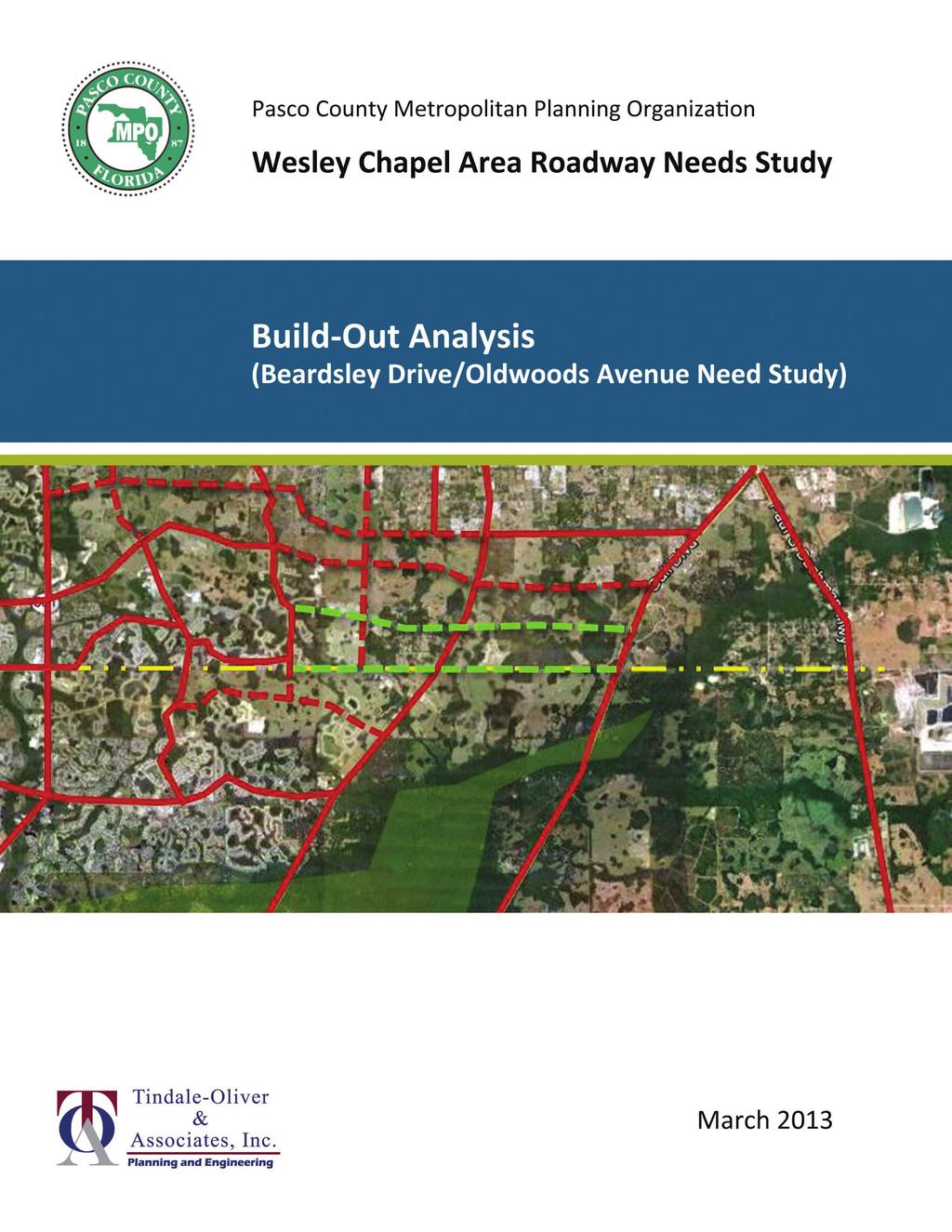
3 Executive Summary The Metropolitan Planning Organization (MPO) undertook a study of the need to develop two new transportation corridors in southeast, one for Beardsley Dr. and one for Oldwoods Av. Their locations are identified in Figure ES 1. The corridors are identified in the MPO s current Long Range Transportation Plan, and are required by the County s Rightof Way Preservation Ordinance (Section 91, Land Development Code). The study was undertaken from the perspective of a build out analysis of long term transportation and circulation needs, using the adopted Tampa Bay Regional (Transportation) Planning Model (TBRPM). The study provided for interaction with interested parties through three project progress meetings and three presentations to the MPO, the Pasco County Development Review Committee, and the Board of County Commissioners. Opportunity for public comment was provided at each of these hearings. Recommendations of the study are: To preserve rights of way to support four lane roadways in both corridors, from Meadow Pointe Blvd. to US 31 for Oldwoods Av. and from Mansfield Rd. to US 31 for the Beardsley Dr. corridor, and To advance the planning process for both of these corridors into route alignment studies. Route alignment studies are needed to identify more exact alignments, traffic operational requirements, right of way needs, stormwater treatment strategies, and pond requirements so that land developments adjacent to the roadways can be planned compatibly with the intended function of the two roadways. In addition, the recommendations are consistent with guidance provided by the Institute of Transportation Engineers Recommended Practice Planning Urban Roadway Systems specifically the objectives of: providing a network that provides a scale suitable for transit, pedestrian, and bicycle travel, routing alternatives, and developing networks with more frequently spaced roadways rather than relying on sparse networks of wide arterials. Wesley Chapel Area Roadway Needs Study Page ES 1 Tindale Oliver and Associates, Inc. March, 213


4 Figure ES 1: Study Area and Corridor Locations Shops at Wiregrass SR 581 Oldwoods Av Hillsborough County Beardsley Dr Legend Existing Road Planned Road Study Road County Line Environmentally Sensitive Area Wesley Chapel Area Roadway Needs Study Page ES 2 Tindale Oliver and Associates, Inc. March, 213
5 WESLEY CHAPEL AREA ROADWAY NEEDS STUDY BUILD-OUT ANALYSIS (BEARDSLEY DRIVE/OLDWOODS AVENUE NEED STUDY) Table of Contents Chapter 1: Introduction Chapter 2: Growth Forecast Chapter 3: Travel Demand Estimates Chapter 4: Recommendation List of Figures 1 1 Study Area List of Tables 2 1 Coverage of Study Area Development Approvals Summary of Network Alternative Performance Appendices A. Socio Economic Data Forecast... A 1 B. Network Alternative Testing Results... B 1 Wesley Chapel Area Roadway Needs Study Page i Tindale Oliver and Associates, Inc. March, 213
6 WESLEY CHAPEL AREA ROADWAY NEEDS STUDY BUILD-OUT ANALYSIS (BEARDSLEY DRIVE/OLDWOODS AVENUE NEED STUDY) Chapter 1: Introduction Southern, along the S.R. 54 and S.R. 56 corridors, has developed rapidly over the past decade, with the construction of thousands of homes and supporting retail service developments. In some areas, travel demands are exceeding the capacity of existing transportation facilities. As the area continues to develop, early agreement is needed on the location and character of new and/or enhanced transportation facilities and services to allow compatible land use planning and development design. Planning for transportation corridors allows developments to be designed to accommodate and to take advantage of the transportation facilities, neighborhood serving land uses can be strategically located, and subdivisions can be designed to protect sensitive land uses from the negative effects of intrusive traffic. The specific issue of interest addressed in this study is the need for and potential future configuration of the Beardsley Drive and the Oldwoods Avenue corridors in the southeast portion of the County. The locations of these two corridors are illustrated in Figure 1 1. The two corridors are identified in the Metropolitan Planning Organization s (MPO s) adopted Long Range Transportation Plan, and reservation of land for these corridors is required by s Right of Way Preservation ordinance, Section 91 of the Land Development Code (LDC). Two private interests have questioned the need for these two corridors, and the LDC provides for a study to evaluate the long term need for them. This study addresses that study option. Relinquishing a potential transportation corridor is a significant decision. Once a corridor is relinquished, it is very difficult and costly to recover both financially and from the perspective of disrupting peoples lives. Thus, careful consideration of the long term needs for circulation in this area is necessary. Study Approach The geographic scope of the study is also illustrated in Figure 1 1. The study road network extended from SR/CR 581 on the west to US 31 on the east, and from Cross Creek Blvd on the south (in the City of Tampa) to SR 54 on the north, inclusive of the boundary roads. This area measures approximately 5.5 miles north to south, and 9.5 miles east to west. Wesley Chapel Area Roadway Needs Study Page 1 1 Tindale Oliver and Associates, Inc. March, 213


7 Figure 1 1: Study Area Wesley Chapel Area Roadway Needs Study Page 1 2 Tindale Oliver and Associates, Inc. March, 213
8 For evaluating future year travel demands, a larger traffic shed was used, as illustrated in Figure 1 1. An estimated build out planning horizon was used for the study area, surrounded by a 25 growth projection for the surrounding areas, and the adopted 235 growth projections for all other areas of the Tampa Bay Regional (Transportation) Planning Model (TBRPM). These projections were developed in coordination with the Growth Management Department. While the Right of Way Preservation ordinance allows for a transportation planning study to be undertaken to customize the requirements of the ordinance, no study procedure has been officially developed or adopted. Thus, general guidance of a publication of the Institute of Transportation Engineers, Planning and Designing Urban Roadway Systems, A Proposed Recommended Practice was consulted. This document lays out guidelines and principles by which a transportation network should be designed. Some of these principles include: Providing modal alternatives Reducing dependence on arterial roads Providing for alternate routes to reach a destination Providing a network with corridor spacing that promotes mobility for all modes specifically corridor spacing of approximately one mile. These principles were applied in conjunction with applications of the TBRPM, which served as the primary analysis tool for the study. Geographic Context South is separated from the major employment centers of Hillsborough County by well fields and wetlands. The major road corridors that provide for north south travel across these well fields and wetlands include US 31, Morris Bridge Road, Bruce B. Downs/CR 581, and I 75. The area of interest lies between Bruce B. Downs Blvd. and Morris Bridge Rd. Since there are no north south corridors between Bruce B. Downs Blvd. and Morris Bridge Rd., the predominant direction of travel demand is for east west movements. To provide a sense of the scale of the area under consideration, the 5.5 mile by 9.5 mile study area was compared to existing conditions in west. The distance from US 19 to Little Rd (CR 1) is approximately 4.5 miles, and the distance from SunRay Dr./Perrine Ranch Rd. to SR is approximately 9.5 miles. In west, travel demands are mostly in the north south direction due to the Gulf of Mexico on the west and wetlands to the east. Additional comparisons of the study area with west are made throughout this report. Wesley Chapel Area Roadway Needs Study Page 1 3 Tindale Oliver and Associates, Inc. March, 213
9 Chapter 2: Growth Forecast Since the decision to relinquish a roadway corridor is essentially a permanent decision, a look at very long term circulation needs is appropriate. For this purpose, a forecast of build out dwellings and employment was made, reflecting currently approved developments, where available, or assumptions regarding possible changes to current land use designations. Staff of each MPO represented in the TBRPM had developed growth projections for 235 and 25, so it was necessary only to develop a build out forecast for the smallest traffic shed area illustrated in Figure 1 1. Appendix A provides a traffic analysis zone map and tables documenting the assumptions on which the land use data for each traffic analysis zone was based. In some cases, the existing traffic analysis zones were divided to create more realistic loadings to the planned road network. Table 2 1: Coverage of Study Area Development Approvals Status Total Area Developable Area Only Acres % of Total Acres % of Total Developed 3,728 16% 3,728 19% Approved/Pending Wetlands 3,262 14% Developable 14,381 62% 14,381 73% Subtotal 17,6 76% Vacant Wetlands 373 2% Developable 1,5 6% 1,5 8% Subtotal 1,848 8% Total,218 1% 19,583 1% The status of development approvals and where assumptions were made for growth in the 25 and Build Out traffic sheds are summarized in Table 2 1. The table indicates that of these traffic shed areas, already approved developments or already developed lands account for 21,371 acres, and the upland area for which growth assumptions were made comprised 1,5 acres, or only 6 percent of these traffic shed areas. For the areas where growth assumptions were made, densities typical of the current land use plan designations were assumed. The total number of dwellings assumed in the 25 plus build out traffic shed area is 114,2, approximately 2.5 times the number of existing dwellings. Growth in employment was to 82,24, approximately 4.2 times the number of existing employees. The difference in employment growth compared to residential growth is indicative of the high proportion of residential uses in the area now. has established incentives and policies in its comprehensive plan and land development regulations to encourage the development of employment based land uses. By way of comparison, in 26 west included,27 dwellings and 21,9 employees. For the Build Out area (the smaller traffic shed within ) the number of dwellings and employees were 2,4 and 9,54, respectively. From the perspective of Wesley Chapel Area Roadway Needs Study Page 2 1 Tindale Oliver and Associates, Inc. March, 213
10 residential dwellings, southeast is expected to become a community of residential size comparable to west today. While similar in residential size, the lower proportion of employment would suggest many residents would have to leave southeast when commuting to work creating longer and more directionally oriented peak hour trips than in west. Wesley Chapel Area Roadway Needs Study Page 2 2 Tindale Oliver and Associates, Inc. March, 213
11 Chapter 3: Travel Demand Estimates The TBRPM was applied to five alternative road networks. Plots of the networks, indicating the number of lanes and 235 peak season daily traffic volumes are provided in Appendix B. In addition, tables summarizing the model output traffic volumes, adjustments to estimate AADT, and comparison of volumes to roadway service volumes (capacity), by road segment are also provided. In this chapter, several general observations applicable to all alternative networks tested are provided, then specific features of the individual networks are discussed. Finally, general conclusions drawn from comparing the networks with each other are discussed. The five alternative networks tested are as follows: The No Build scenario, with neither Beardsley Dr. nor Oldwoods Av., The Oldwoods Only scenario, with Oldwoods Av. as a 4 lane major collector roadway, but no further improvements to Beardsley Dr., With Beardsley Dr. as a 2 lane major collector roadway, but not Oldwoods Av., With both Oldwoods Av. as a 4 lane major collector and Beardsley Dr. as a 2 lane major collector, and With Oldwoods Av. as a 2 lane major collector roadway, and Beardsley Dr. as a 4 lane major collector roadway. Noteworthy observations that apply to all of the scenarios tested are: All networks included the development of Overpass Road (to the north of SR 54, serving the proposed Pasadena Hills development area), having a new interchange with I 75 at Overpass Rd. (approximately mid way between SR 54 and SR ). By 235, very heavy traffic volumes are forecasted on I 75, as well as on SR 54 and SR 56 at their interchanges with I 75. Neither the Cost Feasible Plan nor the Needs Plan provide solutions that maintain level of service D, or even E, conditions in the interchanges of I 75 with these two State highways. Even though the TBRPM did not exhibit substantial changes in future traffic volumes at these roads resulting from each tested alternative, the County should take advantage of opportunities to develop additional crossings between the east and west sides of I 75 at other locations to reduce congestion and provide the community with route choices. Future volume forecasts also indicate high traffic volumes on SR 56 at SR 581, and at Mansfield Blvd. volumes that approach the need for grade separation. Provision of route alternatives would defer the need for such facilities, and provide alternate travel routes for those who can take advantage of them. Beardsley Dr. more naturally attracts more traffic than Oldwoods Av. because (in conjunction with County Line Rd.) it provides a near continuous corridor from Dale Mabry Highway on the west, over I 75, and into the study area, and potentially to US 31. This is a distance of 16 miles. In the future, a connection will be made from County Line Rd. into the Cypress Creek Town Center regional shopping center, providing secondary access to the center from the east, west, and south. At Mansfield Rd. and to Wesley Chapel Area Roadway Needs Study Page 3 1 Tindale Oliver and Associates, Inc. March, 213
12 its east, however, discontinuity is introduced via an off set intersection and limited right of way width as it traverses through a residential development. Oldwoods Av., by contrast, cannot be extended west of Meadow Point Blvd. without substantial disruption to existing residential subdivisions and environmentally sensitive lands. Thus, it s continuity can be maintained only from Meadow Point Blvd. eastward to US 31, a distance of only 5.5 miles. In the final network testing, it appears that a role of community collector roadway is appropriate, serving the adjacent subdivisions and on which community facilities, such as parks, libraries, schools, neighborhoodserving retail, government services, community centers, and houses of worship might be located. Specific results associated with each network alternative are discussed below. Network Test 1: No Build Scenario Neither Beardsley Dr. or Oldwoods Av. are developed in this scenario. This scenario served as a benchmark scenario to which other alternatives were compared, as discussed below. Network Test 2: Oldwoods Av. (4 lanes) Only Oldwoods Av. was tested as a four lane major collector roadway extending continuously from Meadow Pointe Blvd. to US 31. It attracted from 16, to 3, vehicles per day (vpd), which can be comfortable served with a mixture of two and four lane road sections. Network Test 3: Beardsley Dr. (2 lanes) Only Beardsley Dr. was tested as a two lane major collector roadway extending, in combination with County Line Rd., essentially continuously from Dale Mabry Highway to US 31. In the study area, it attracted from 11, to 15, vehicles per day, which can be comfortably served by a two lane roadway. Network Test 4: Oldwoods Av. (4 lanes) and Beardsley Dr. (2 lanes) This scenario represented a combination of network tests 2 and 3. The daily traffic volumes attracted by Oldwoods Av. were lower, ranging from 12, to 2,, but still requiring a mix of two and four lane road sections for comfortable service. Volumes attracted by Beardsley Dr. did not change much, ranging from 1, to 16,. Network Test 5: Oldwoods Av. (2 lane) and Beardlsey Dr. (4 lane) In light of the above observations, a final network test was undertaken that better aligned the roadway network to the travel demand trends observed in the above tests. This involved the concept of developing the County Line Rd. / Beardsley Dr. alignment as a major corridor, and Oldwoods Av. as a lower scale community collector road. Traffic volumes on Beardsley were in the 25, to 3, vehicles per day range, requiring a four lane roadway. In this test, Oldwoods Av. attracted volumes in the 5, to 12, vpd range, suitable for a two lane roadway throughout. Wesley Chapel Area Roadway Needs Study Page 3 2 Tindale Oliver and Associates, Inc. March, 213
13 Table 3 1: Summary of Network Alternative Performance Alternative Pk Hr VMT Pk Hr VHT Pk Hr Avg Speed (mph) Weighted V/C Ratio Pk Hr VHT Reduction Daily VHT Reduction Savings / Day Savings / Year 25-Year Saving No-Build 278,755 12, $ $ $ Build-Out Oldwoods Ave (4D) 277,85 12, $1,683 $54,83 $8,79,28 Build-Out Beardsley Dr (2D) 278,811 12, $9,595 $2,878,5 $5,124,6 Build-Out Beardsley Dr (2D) & Oldwoods Ave (4D) 278,9 11, $1,4 $3,94,3 $53,882,3 Build-Out Beardsley Dr (4D) & Oldwoods Ave (2D) 282,885 11, $16,456 $4,936,736 $85,964,121 Table 3 1 compares the performance of the network tests in a summary fashion. The table summarizes the vehicle miles of travel and vehicle hours of travel in the study network. These values are based on the volumes and congested travel times on road segments from the TBRPM model. Beardsley Dr. and Oldwoods Av. comprise only 9 percent of the lane miles of that network, and carry approximately 7 percent of the travel. As a result, the effects of the network changes may appear small, but the longer term implications are worthwhile, as discussed below. The network alternatives are listed in order of their testing, which also corresponds to their order of effectiveness. As the networks advance, the number of vehicle miles travelled increases, yet the number of vehicle hours of travel decreases. The implication of increased vehicle miles of travel is that in this very congested area, provision of additional facilities provides relief to other facilities, and additional travel is attracted into this network. Even as additional travel is attracted into the network, the vehicle hours of travel decrease, indicating better alignment of facilities with travel demands and less congestion as the network alternatives are advanced. The weighted v/c ratio is a measure incorporated into the County s Comprehensive Plan Transportation Element to monitor the level of congestion in the transportation system. The trend indicated is also consistent with the average speed indications as the alternatives advance, less congestion results. Values of the weighted v/c ratio near 1. indicate that the average degree of congestion is at level of service D, which means that roughly half of the travel in the study network is forecasted to occur on roads operating at loadings that are more congested than the traditional standard. The value of the time savings of the alternative improvement plans is also summarized in Table 3 1. The peak hour travel times are compared, and the time savings for each alternative against the no build scenario were computed. The peak hour time savings were expanded to a daily time savings (2.25 times the peak hour savings), and daily monetary savings (based on 1.3 persons per vehicle and $14 per person hour) were computed. The daily time savings were converted to yearly savings (assuming 3 equivalent weekdays per year), and the present value of 25 years of these savings were then estimated (assuming a 3 percent per year discount rate). Even though the time savings on a single day may appear small in the summary table, the estimated potential savings to travelers in the study road network over a 25 year period is $86 million. These potential savings are based only on time savings, and do not include fuel or vehicle operating costs. The magnitude of potential savings would justify the expenditure of public funds to implement the improvements. Wesley Chapel Area Roadway Needs Study Page 3 3 Tindale Oliver and Associates, Inc. March, 213
14 By way of comparison to west, the total build out daily traffic volumes estimated for the east west roads in the study area is 126,3, and (with Beardsley Dr. and Oldwoods Av.) is served by five transportation corridors (Beardsley Dr., Oldwoods Av., SR 56, Chancey Rd., and SR 54) with 2 lanes. In this case, Oldwoods Av. is a relatively short corridor. In west, a total north south daily traffic volume of 1,1 daily trips was served in 21 on essentially five north south corridors (US 19, Washington St./Grand Blvd., Congress St./Madison St., Rowan Rd., and Little Rd.) also with 2 lanes. The similarities are apparent, so the development of a transportation network in southeast with five corridors and 2 lanes is likely to provide a quality of service comparable to that currently provided to west. The compatibility of the transportation network to serve alternate modes is also a relevant planning issue. In particular, transit service, bicycle travel, and even some pedestrian travel will occur on this network. A network that has few parallel roads and poor connectivity requires travel of greater distances to reach desired destinations. With a finer arterial/collector grid network, shorter paths become available for travel, improving accessibility to transit routes and the attractiveness of walking or bicycling for some trips. Another issue that is affected by road network design is the ability of the system to absorb the effects of incidents. If an incident, such as a traffic crash, a roadway or utility maintenance issue, a sinkhole, or other event were to occur that disrupts traffic flow, it is attractive to have alternate routes available within a reasonable distance to accommodate displaced travel. In the absence of Beardsley Dr. and Oldwoods Av., there would be no alternate east west roadway corridor from SR/CR 581 to Morris Bridge Rd., (or US 31), between Cross Creek Blvd. in Tampa and SR 56 in a distance of 3. to 3.8 miles. If, for example, traffic flow on SR 56 is disrupted, traffic would either have to detour one to two miles northward to Chancey Rd. or SR 54, or 3.8 miles southward to Cross Creek Blvd. in Tampa. Wesley Chapel Area Roadway Needs Study Page 3 4 Tindale Oliver and Associates, Inc. March, 213
15 Chapter 4: Recommendation In light of the foregoing analysis, the following is recommended: Preserve right of way for four lane roadways for both Beardsley Dr. and Oldwoods Av. The right of way for Beardsley Dr. should extend from Mansfield Blvd. to US 31, and the right of way for Oldwoods Av. should extend from Meadow Pointe Blvd. to US 31, and Advance the planning process for both of these corridors into route alignment studies. Route alignment studies are needed to identify more exact alignments, traffic operational requirements, right of way needs, stormwater treatment strategies, and pond requirements so that land developments adjacent to the roadways can be planned compatibly with the intended function of the two roadways. The recommendations are consistent with guidance provided by the Institute of Transportation Engineers Recommended Practice Planning Urban Roadway Systems specifically the objectives of: providing adequate capacity for expected travel demands, providing a network at a scale suitable for transit, pedestrian, and bicycle travel, providing for routing alternatives for normal daily traffic flow as well as incident management purposes, and developing networks with more frequently spaced roadways rather than relying on sparse networks of wide arterials. Wesley Chapel Area Roadway Needs Study Page 4 1 Tindale Oliver and Associates, Inc. March, 213
16 Appendix A Socio Economic Data Forecast Wesley Chapel Area Roadway Needs Study Page A 1 Tindale Oliver and Associates, Inc. March, 213
17 Socioeconomic Data Comparison TAZ # Dwelling Units Employment 26 Build-Out Build-Out Build-Out ,63 1,5 1, ,7 1,979 2,4 2, ,129 1,616 2,15 2, ,2 2,111 2,6 2, ,148 1,1 1, ,397 3,266 4,73 4,73 1,129 1,3 1,818 1, , 1,27 1, ,13 1,384 1, ,64 1,7 1,9 1, ,629 1,995 1, ,658 2, 3,5 3, ,117 1, ,988 2,224 2,773 2, ,216 1,516 1, ,162 1,663 2,74 2, ,2 1, ,459 1, ,2 1,2 1, ,4 1, , ,7 2,161 2, ,56 3,6 4, ,2 2,356 2,4 2,4 1,116 1,512 1,562 1, ,65 1,65 1, ,15 1,15 1, ,962 1,962 1, ,177 4, ,39 1,375 1, ,1 1,1 1, ,536 2,536 3, , , ,24 1,24 1, ,3 1,693 1, ,77 1,77 1, ,196 2,616 4, ,14 1,455 1,455 1, ,5 1,753 1, ,9 1, ,57 1,57 1, ,279 5,148 1, ,874 2,167 2,167 2, ,12 4,4 4,4 3, ,763 2,6 4, ,8 2,572 2, ,125 1, ,7 1,958 1, ,7 2,1 2, ,559 1,559 2, , ,78 1, ,3 2, ,8 1, , ,2 1,368 1,568 1, A - 1
18 Socioeconomic Data Comparison TAZ # Dwelling Units Employment 26 Build-Out Build-Out Build-Out 2 2 1,885 3,75 3,75 3, ,57 1,57 1, ,15 1,35 1, , ,496 1, ,721 3,39 3,39 3, ,545 1,684 1,965 1, ,12 1,114 1, ,17 1,57 1, ,658 1, , ,537 1,537 2,2 66 2,191 2,191 6, , ,7 1 1,273 1,273 4, ,4 1,493 1, ,29 2, , , , ,72 1,491 2,138 2, ,18 1, ,27 1,47 1,537 1, ,2 1,749 1,983 1, ,164 1,362 1,513 1, ,7 1,7 Total,351 92,69 13,6 114,2 19,639 55,81 68,828 82,111 A - 2
19 A B CR CR MANSFIELD BLVD BLVD MANSFIELD BLVD GALL BLVD GALL KINNAN ST ST KINNAN COURT ST ST COURT RD LANE RD LANE RD ALLEN RD S ALLEN S ST 2TH ST 2TH Legend County Line 31 t u Study Area TAZs Non-Study Area TAZs RRDD BBRR IIDD GGEE 762 CROSS CREEK CREEK BLVD BLVD CROSS 26 H i 763 llsborough County 76 BLVD PRESERVE BLVD OAK PRESERVE OAK AVENUE C AVENUE C DRIVE GROVE DRIVE PALM GROVE PALM TUCKER RD RD TUCKER RD CHANCEY RD CHANCEY OLDWOODS AVE AVE OLDWOODS 25 NORTH BLVD BLVD NORTH A B 38 BEARDSLEY DR DR BEARDSLEY CO OUN C UNTY TY LI LINE NE RD RD 31 t u MMOO RRRR IISS 54 CR E COUNTY COUNTY LINE LINE RD RD E CR 54 CR RD SPRINGS RD CRYSTAL SPRINGS CRYSTAL A B A B 54 A B 228 WYNDFIELDS BLVD BLVD WYNDFIELDS SR SR 2279 MEADOW POINTE POINTE BLVD BLVD MEADOW CCHH BBLL VVDD CCRR 55/ /W WE ESS LLEE YY 75 D BLV TER POR A B 29 GEIGER RD RD GEIGER 54 RD COATS RD COATS 28 EIL E ILA AN ND DB BLLV VD D ROAD BRIDGE ROAD MORRIS BRIDGE MORRIS 2276 NE N EW WR RIV IVE ER RR RD DE EX XTT t u ST 7TH 54 A B XTT EX SE SS AS PA YP BY SB ILLLS -HIL ZZ-H DEAN DAIRY RD DAIRY RD DEAN BLVD EILAND BLVD EILAND 2271 WIRE RD RD WIRE KING RD FORT KING RD FORT CR HANDCART HANDCART RD RD CR CCUU RRLL EEYY 75 RRDD BOYETTE RD RD BOYETTE O SC PA D OL AD RO 484 F BBRR UUCC EE BB DDOO W W NNSS UUSS 11 BBLL VVDD 275 A Miles Map A-1 Study Area TAZs
20 Appendix B Network Alternative Testing Results In this appendix, worksheets and maps associated with each alternative are identified by using page numbers in the format B xx yy, where xx corresponds to the scenario and yy is the page number within the scenario. The scenarios are numbered as follows: Model Validation 2. Build Out Condition, No Build Scenario 3. Build Out Condition, Oldwoods Av. (4 lane) Only Scenario 4. Build Out Condition, Beardsley Dr. (2 lane) Only Scenario 5. Build Out Condition, Oldwoods Av. (4 lane) and Beardsley Dr. (2 lane) Scenario 6. Build Out Condition, Oldwoods Av. (2 lane) and Beardsley Dr. (4 lane) Scenario Wesley Chapel Area Roadway Needs Study Page B 1 Tindale Oliver and Associates, Inc. March, 213
21 Miles F 26 Validation Roadway Network, TAZs, Area Types, and Facility Types Map B-1 Legend 2 Lanes 3 Lanes 4 Lanes 6 Lanes 8 Lanes County Line Study Area TAZs Non-Study Area TAZs Hillsborough County Hillsborough County Area Type FacilityType ## ## B - 1-1
22 Miles F 235 Cost Affordable Roadway Network, TAZs, Area Types, and Facility Types Map B-2 Legend 2 Lanes 3 Lanes 4 Lanes 6 Lanes 8 Lanes County Line Study Area TAZs Non-Study Area TAZs Hillsborough County Hillsborough County Area Type FacilityType ## ## B - 1-2
23 Hillsborough County F 26 Miles B Legend ## TAZs 2 Lanes 3 Lanes 4 Lanes 6 Lanes 8 Lanes Centroid Connectors County Line Study Area TAZs Non-Study Area TAZs Raw Model Volumes Map B-3 Validation Roadway Network, and Raw Model Volumes
24 Miles F No Build Scenario Capacity Constrained Raw Model Volumes Map B-4 Legend TAZs 1 Lane 2 Lanes 3 Lanes 4 Lanes 6 Lanes 8 Lanes 1 Lanes Centroid Connectors County Line Study Area TAZs Non-Study Area TAZs Hillsborough County Hillsborough County Raw Model Volumes ## B - 2-1
25 No Build Scenario Segment LOS Thresholds Raw Model Volume Build Out AADT Functional Lane Area Facility Facility 26 Length On From To Class Type Type Type Class A B C D E AADT 26 Build Out Method A (1) Method B (2) Build Out AADT Cross Creek Blvd Bruce B Downs Blvd Kinnan St 1.62 Collector 4D Urban Art CI Major County 26,4,,, 27,9 29,654 37,31 35,95 35,165 35,13 35, Average F ,7 6, ,56 Cross Creek Blvd Kinnan St C.R Collector 4D Urban Art CI Major County 26,4,,, 12,5 8,149 19,548 29,985,9 26,657 26,5 Average C.8 71,55 57, ,575 Oak Preserve Blvd Kinnan St Meadow Pointe Blvd 1.4 Collector 4D Urban Art CII Major County 22,5 29,9,6 6,162 5,854 5,854 5,85 Method B C.2 8,19 1, Oak Preserve Blvd Meadow Pointe Blvd C.R Collector 4D Urban Art CII Major County 22,5 29,9,6 8,184 7,775 7,775 7,75 Method B C.26 12,6 3, Beardsley Dr Mansfield Blvd Meadow Pointe Dr 1.54 Collector 2U Urban Art CII Major County 9,5 13,7 14,6 14,663 13,93 13,93 14, Method B E ,56 22, ,118 Beardsley Dr Meadow Pointe Dr Wyndfields Blvd n/a n/a n/a n/a n/a n/a n/a n/a n/a n/a n/a Method B n/a n/a n/a n/a Beardsley Dr Wyndfields Blvd C.R.579 n/a n/a n/a n/a n/a n/a n/a n/a n/a n/a n/a Method B n/a n/a n/a n/a Beardsley Dr C.R.579 U.S.31 n/a n/a n/a n/a n/a n/a n/a n/a n/a n/a n/a Method B n/a n/a n/a n/a County Line Rd Bruce B Downs Blvd Mansfield Blvd 2.35 Arterial 4D Urban Art CI Major County 26,4,,, 14,2 19,,196 24,7 26,694 25,351 25,5 Average B.77 59,925, ,172 Oldwoods Ave Meadow Pointe Dr Wyndfields Blvd 1.11 Collector 2U Urban Art CII Major County 9,5 13,7 14,6 12,82 12,162 12,162 12, Method B D.88 13, 11, Oldwoods Ave Wyndfields Blvd C.R.579 n/a n/a n/a n/a n/a n/a n/a n/a n/a n/a n/a Method B n/a n/a n/a n/a Oldwoods Ave C.R.579 U.S Collector 4D Urban Art CII Major County 22,5 29,9,6 25,794 24,54 24,54 24,5 Method B D.82 64,925 53, ,495 S.R.56 Bruce B Downs Blvd Shoppes of Wiregrass. Arterial 6D Urban Art CI State 45, 53,7 55,3 55,3 53,214 5,553 5,553 5,5 Method B C.91, 21, S.R.56 Shoppes of Wiregrass Mansfield Blvd 1.2 Arterial 6D Urban Art CI State 45, 53,7 55,3 55,3 58,511 55,585 55,585 55,5 Method B F 1. 66,6 66, ,386 S.R.56 Mansfield Blvd Meadow Pointe Blvd 2.6 Arterial 6D Urban Art CI State 45, 53,7 55,3 55,3 63,511 6,5 6,5 6,5 Method B F ,63 136, ,6 S.R.56 Meadow Pointe Dr Wyndfields Blvd 2.34 Arterial 6D Urban Art CI State 45, 53,7 55,3 55,3 49,185,726,726,5 Method B C.84 18,81 91, ,193 S.R.56 Wyndfields Blvd New River Rd Ext. 1.7 Arterial 6D Urban Art CI State 45, 53,7 55,3 55,3,85,658,658,5 Method B B.75,45, ,376 S.R.56 New River Rd Ext. C.R Arterial 6D Urban Art CI State 45, 53,7 55,3 55,3,4,74,74,5 Method B B.79 28,71 22, S.R.56 C.R.579 U.S Arterial 6D Urban Art CI State 45, 53,7 55,3 55,3 36,276 34,2 34,2 34,5 Method B B.62 99,36 61, ,128 Chancey Rd Ext. Bruce B Downs Blvd Porter Blvd 1.19 Arterial 4D Urban Art CII Major County 22,5 29,9,6 19,93 18,98 18,98 19, Method B C.64 22,61 14, Chancey Rd Ext. Porter Blvd Meadow Pointe Blvd 2.22 Arterial 4D Urban Art CII Major County 22,5 29,9,6 38,4 36,51 36,51 36,5 Method B F ,3 98, ,37 Chancey Rd Ext. Meadow Pointe Blvd Wyndfields Blvd 1.51 Arterial 4D Urban Art CII Major County 22,5 29,9,6 28,1 27, 27, 27, Method B D.9 4,77 36, ,283 Chancey Rd Wyndfields Blvd New River Ext. 1.1 Arterial 4D Urban Art CII Major County 22,5 29,9,6 3,127 28,621 28,621 28,5 Method B D.95 28,785 27, Chancey Rd New River Ext. C.R Arterial 4D Urban Art CII Major County 22,5 29,9,6 21,93 2,38 2,38 2, Method B C.67 15, 1, Chancey Rd C.R.579 Coats Rd 2.3 Arterial 2U Urban Art CII Major County 9,5 13,7 14,6 7,6 6,219 13,76 16,75 14,713 15,7 15,5 Average F 1.13,5 35, ,558 Chancey Rd Coats Rd U.S Arterial 2U Urban Art CII Major County 9,5 13,7 14,6 9,3 6,175 11,7 17,285 14,7 15,811 16, Average F ,36, ,4 S.R.54 Bruce B Downs Blvd Mansfield Blvd.37 Arterial 6D Urban Art CI State 45, 53,7 55,3 55,3 39,5 36,891 63,32 67,779 64,59 66,185 66, Average F , 29, ,1 S.R.54 Mansfield Blvd C.R.577/Z West Ext 1.93 Arterial 6D Urban Art CI State 45, 53,7 55,3 55,3,5 25,5 68,456 84,48 72,264 78,6 78,5 Average F ,55 215, ,491 S.R.54 C.R.577/Z West Ext Meadow Pointe Blvd 1.16 Arterial 4D Urban Art CI State 29,3 35,5 36,7 36,7 26,5 17,97,3 48,75 4,11,47 4, Average F 1.9,4 5, ,193 S.R.54 Meadow Pointe Blvd Wyndfields Blvd 1.28 Arterial 4D Urban Art CI State 29,3 35,5 36,7 36,7 25, 14,682,869 72,996 51,778 62,387, Average F 1. 66,56 94, ,915 S.R.54 Wyndfields Blvd New River Rd Ext Arterial 4D Urban Art CI State 29,3 35,5 36,7 36,7 25, 12,216 29,4 59, 4,983 5,27, Average F 1.12,48 58, ,367 S.R.54 New River Rd Ext. C.R Arterial 4D Urban Art CI State 29,3 35,5 36,7 36,7 25, 11,536 35,3 75,915,9,9,5 Method B F ,15 45, S.R.54 C.R.579 Coats Rd 2.14 Arterial 4D Urban Art CII State 25,,2 35,1 15,1 8,49 3,487 54,745 36,74 36,74 36, Method B F ,184 83, ,6 S.R.54 Coats Rd City Limits 1. Arterial 4D Urban Art CII State 25,,2 35,1 18,65 8,2,571 54,936,4,4,5 Method B E ,91 49, ,5 S.R.54 City Limts U.S.31. Arterial 4D Urban Art CII State 25,,2 35,1 16,6 5,959 16,264 45,37 26,39 26,39 26,5 Method B D.8 13,727 1, Z West Ext C.R.577/Z West Ext Meadow Pointe Blvd 1.6 Arterial 4D Urban Art CI State 29,3 35,5 36,7 36,7,1 29,59 29,59 29,5 Method B C.8,27 25, ,18 Z West Ext Meadow Pointe Blvd Wyndfield Blvd 1.68 Arterial 4D Urban Art CI State 29,3 35,5 36,7 36,7 39,724 37,738 37,738 37,5 Method B F , 64, ,7 Z West Ext Wyndfield Blvd New River Ext.95 Arterial 4D Urban Art CI State 29,3 35,5 36,7 36,7 4,518 38,492 38,492 38,5 Method B F ,575 38, ,636 Z West Ext New River Ext C.R Arterial 4D Urban Art CI State 29,3 35,5 36,7 36,7 4,65 38,62 38,62 38, Method B F 1.4 2, 21, Eiland Blvd Handcart Road Dean Dairy Rd 2.3 Arterial 4D Urban Art CII Major County 22,5 29,9,6 14,1 8,9,673 51,629 36,663 36,663 36,5 Method B F ,95 9, ,634 Eiland Blvd Dean Dairy Rd US Arterial 4D Urban Art CII Major County 22,5 29,9,6 13,5 14,81,2 29,38 3,5 29,715 3, Average E 1. 5,1 5, ,96 Bruce B Downs Blvd Cross Creek Blvd Oaks Preserve Blvd 1.2 Arterial 6D Urban Art CI State 45, 53,7 55,3 55,3 38,6 37,25 88,1 92,4 87,4 89,854 87,5 Average F , 166, ,175 Bruce B Downs Blvd Oaks Preserve Blvd County Line Rd.7 Arterial 4D Urban Art CI State 45, 53,7 55,3 55,3 38,6 34,585 82,698 92,298 84,37 88,33 84,5 Average F ,15 9, ,56 Bruce B Downs Blvd County Line Rd S.R Arterial 4D Urban Art CI State 45, 53,7 55,3 55,3 38,5 27,582 68,716 95,916 77,577 77,577 77,5 Method B F ,725 17, ,4 Bruce B Downs Blvd S.R.56 Chancey Rd Ext 1.9 Arterial 6D Urban Art CI State 45, 53,7 55,3 55,3 18,4 17,2 67,618 72,159 66,257 69,28 66,5 Average F ,35 151, ,73 Bruce B Downs Blvd Chancey Rd Ext S.R Arterial 6D Urban Art CI State 45, 53,7 55,3 55,3 17,7 14,59 45,7 55,186,892 51,39, Average C.85 74,73 63, ,891 Kinnan St Cross Creek Blvd Oaks Preserve Blvd 1. Collector 2U Urban Art CII Major County 9,5 13,7 14,6 13,5 12,649 12,649 12,5 Method B D.91 18, 16, ,9 Kinnan St Oaks Preserve Blvd Beardsley Dr/Strickland Rd.98 Collector 2U Urban Art CII Major County 9,5 13,7 14,6 11,283 1,719 1,719 1,5 Method B D.77 1,29 7, Mansfiel Blvd Beardsley Dr/Strickland Rd County Line Rd. Collector 4D Urban Art CII Major County 22,5 29,9,6 26, 25,14 25,14 25, Method B D.84 5,75 4, Mansfiel Blvd County Line Rd S.R Collector 4D Urban Art CII Major County 22,5 29,9,6 25,264 24,1 24,1 24, Method B D.8 4,, ,2 Porter Blvd S.R.56 Chancey Rd Ext 1.22 Collector 4D Urban Art CII Major County 22,5 29,9,6 38,691 36,756 36,756 37, Method B F ,14 55, ,1 Porter Blvd Chancey Rd Ext S.R Collector 4D Urban Art CII Major County 22,5 29,9,6 38,254 36,3 36,3 36,5 Method B F ,795 81, ,859 Meadow Pointe Blvd Oak Preserve Blvd Beardsley Dr. Collector 4D Urban Art CII Major County 22,5 29,9,6 14,153 13,5 13,5 13,5 Method B C.45 7,2 3, Meadow Pointe Blvd Beardsley Dr Oldwoods Ave.89 Collector 4D Urban Art CII Major County 22,5 29,9,6 2, 24,926,68,68,5 Method B D.79 2,915 16, Meadow Pointe Blvd Oldwoods Ave S.R Collector 4D Urban Art CII Major County 22,5 29,9,6 2,912 19,866 19,866 2, Method B C.67 17,6 11, Meadow Pointe Blvd S.R.56 Chancey Rd Ext.9 Collector 4D Urban Art CII Major County 22,5 29,9,6 2,563 28,372 26,953 26,953 27, Method B D.9 24,3 21, ,17 Meadow Pointe Blvd Chancey Rd Ext S.R Collector 4D Urban Art CII Major County 22,5 29,9,6 2,74 24,29 22,999 22,999, Method B D.77 39,1 3, ,453 Meadow Pointe Blvd S.R.54 Z West Ext.45 Collector 4D Urban Art CII Major County 22,5 29,9,6 28,986 27,537 27,537 27,5 Method B D.92 12,375 11, Wyndfield Blvd Beardsley Dr Oldwoods Ave n/a n/a n/a n/a n/a n/a n/a n/a n/a n/a n/a Method B n/a n/a n/a n/a Wyndfield Blvd Oldwoods Ave S.R.56.7 Collector 4D Urban Art CII Major County 22,5 29,9,6 12,74 12,13 12,13 12, Method B C.4 8,4 3, Wyndfield Blvd S.R.56 Chancey Rd Ext.81 Collector 4D Urban Art CII Major County 22,5 29,9,6 3,355 28,837 28,837 29, Method B D.97,49 22, ,73 Wyndfield Blvd Chancey Rd Ext S.R Collector 4D Urban Art CII Major County 22,5 29,9,6 28,912 27,6 27,6 27,5 Method B D.92 29,7 27, ,2 Wyndfield Blvd S.R.54 Z West Ext 1.27 Collector 4D Urban Art CII Major County 22,5 29,9,6,719 22,5 22,5 22,5 Method B C.75 28,575 21, ,58 New River Rd S.R.56 Chancey Rd Ext.76 Collector 2U Urban Art CII Major County 9,5 13,7 14,6 8,2 8,48 8,48 8,5 Method B C.59 6,118 3, New River Rd Chancey Rd Ext S.R Collector 2U Urban Art CII Major County 9,5 13,7 14,6 1,5 9,818 9,818 9,8 Method B D.72 7,35 5, New River Rd S.R.54 Z West Ext 1.8 Collector 2U Urban Art CII Major County 9,5 13,7 14,6 7,27 6,676 6,676 6,7 Method B C.49 12,6 5, C.R.579 Cross Creek Blvd Oak Preserve Blvd 1.9 Arterial 2U Urban Art CI State 9,6 15,4 16,5 16,5 8, 12,285 28,5 18,58,5 21,7,5 Average F 1. 25,615 36, ,1 C.R.579 Oak Preserve Blvd Beardsley Dr 1.22 Arterial 2U Urban Art CI State 9,6 15,4 16,5 16,5 8, 12,3 22, 14,5 17,579 16,56 17,5 Average F ,35 22, C.R.579 Beardsley Dr Oldwoods Ave 1.1 Arterial 2U Urban Art CI State 9,6 15,4 16,5 16,5 8,3 12,371,62 15,3 18,456 16,965 18,5 Average F ,35 22, ,129 C.R.579 Oldwoods Ave S.R Arterial 4D Urban Art CI State 29,3 35,5 36,7 36,7 8,3 12,8 35,,792 3,1 26,967 3, Average C.82 21,3 17, C.R.579 S.R.56 Chancey Rd.93 Arterial 4D Urban Art CI State 29,3 35,5 36,7 36,7 8,3 12,682 28,791 18,8,64 21,2,5 Average B.64 21,855 13, C.R.579 Chancey Rd S.R Arterial 4D Urban Art CI Major County 26,4,,, 1,5 11,5 37,8 34,459 35,288 34,874 35,5 Average F ,625 28, ,58 C.R.579 S.R.54 Eiland Blvd 1.85 Arterial 4D Urban Art CI Major County 26,4,,, 11,5 9,768 19,96,499 21,182 22,3 21, Average B.64 38,85 24, ,281 Coats Rd Chancey Rd S.R Collector 2U Urban Art CII Other 6,8 9,9 1,5 5,973 14,86 14,117 14,117 14, Method B F 1. 21,14 29, ,17 Dean Dairy Road S.R.54 Eiland Blvd 1.1 Collector 2U Urban Art CII Other 6,8 9,9 1,5 5,3 6,6 9,6 7,591 7,897 7,7 7,9 Average D.8 7,979 6, U.S.31 Beardsley Dr Oldwoods Ave 1.61 Arterial 4D Urban Art CI State 29,3 35,5 36,7 36,7 14,3 22,457 61,399 39,97 51,295 45,196 51,5 Average F , , ,1 U.S.31 Oldwoods Ave S.R Arterial 4D Urban Art CI State 29,3 35,5 36,7 36,7 14,3 22,4 48, 3,621 38,621 34,621 38,5 Average F 1.5,12 45, ,3 U.S.31 S.R.56 Chancey Rd.78 Arterial 2U Urban Art CI State 29,3 35,5 36,7 36,7 14,3 21,824,16 3,2 37,9,8 37,5 Average F ,175 29, ,69 U.S.31 Chancey Rd S.R Arterial 2U Urban Art CI State 29,3 35,5 36,7 36,7 15,8 12,77 38,564 5,4 4,963 45,77, Average F ,29, ,23 Total ,97,281 3,26, ,18 Notes: (1) Method A Build Out AADT = 26 AADT x (Build Out Raw Model Volume / 26 Raw Model Volume) (2) Method B Build Out AADT = 26 AADT + [(Build Out Raw Model Volume 26 Raw Model Volume) x MOCF] (3) Assumes LOS STD = "D" Rounded AADT Comments Build Out LOS Build Out v/c (3) VMT VMT x v/c Travel Time [minutes] Travel Time [hours] Vehicle Hours of Travel [veh hr] B - 2-2
26 Miles F Build Out Oldswood Only Capacity Restraint Raw Model Volumes Map B-5 Hillsborough County Hillsborough County Raw Model Volumes ## Legend TAZs 1 Lane 2 Lanes 3 Lanes 4 Lanes 6 Lanes 8 Lanes 1 Lanes Centroid Connectors County Line Study Area TAZs Non-Study Area TAZs B - 3-1
27 Oldwoods Ave Only Scenario Segment LOS Thresholds Raw Model Volume Build Out AADT Functional Lane Area Facility Facility 26 Length On From To Class Type Type Type Class A B C D E AADT 26 Build Out Method A (1) Method B (2) Build Out AADT Cross Creek Blvd Bruce B Downs Blvd Kinnan St 1.62 Collector 4D Urban Art CI Major County 26,4,,, 27,9 29,654 37,371 35,161 35,2 35,196 35, Average F ,7 6, ,518 Cross Creek Blvd Kinnan St C.R Collector 4D Urban Art CI Major County 26,4,,, 12,5 8,149 19,613 3,85,391 26,738 26,5 Average C.8 71,55 57, ,571 Oak Preserve Blvd Kinnan St Meadow Pointe Blvd 1.4 Collector 4D Urban Art CII Major County 22,5 29,9,6 6,183 5,874 5,874 5,85 Method B C.2 8,19 1, Oak Preserve Blvd Meadow Pointe Blvd C.R Collector 4D Urban Art CII Major County 22,5 29,9,6 7,612 7,2 7,2 7,25 Method B C.24 11,818 2, Beardsley Dr Mansfield Blvd Meadow Pointe Dr 1.54 Collector 2U Urban Art CII Major County 9,5 13,7 14,6 15,2 14,48 14,48 14,5 Method B E ,, ,2 Beardsley Dr Meadow Pointe Dr Wyndfields Blvd n/a n/a n/a n/a n/a n/a n/a n/a n/a n/a n/a n/a n/a... Beardsley Dr Wyndfields Blvd C.R.579 n/a n/a n/a n/a n/a n/a n/a n/a n/a n/a n/a n/a n/a... Beardsley Dr C.R.579 U.S.31 n/a n/a n/a n/a n/a n/a n/a n/a n/a n/a n/a n/a n/a... County Line Rd Bruce B Downs Blvd Mansfield Blvd 2.35 Arterial 4D Urban Art CI Major County 26,4,,, 14,2 19,,451 24,197 26,937 25,567 25,5 Average B.77 59,925, ,185 Oldwoods Ave Meadow Pointe Dr Wyndfields Blvd 1.11 Collector 4D Urban Art CII Major County 22,5 29,9,6 21,92 2,37 2,37 2, Method B C.67 22,2 14, Oldwoods Ave Wyndfields Blvd C.R Collector 4D Urban Art CII Major County 22,5 29,9,6 16,3 15,9 15,9 15,5 Method B C. 24,5 12, Oldwoods Ave C.R.579 U.S Collector 4D Urban Art CII Major County 22,5 29,9,6 26,89 25,9 25,9 25,5 Method B D.85 67,575 57, ,682 S.R.56 Bruce B Downs Blvd Shoppes of Wiregrass. Arterial 6D Urban Art CI State 45, 53,7 55,3 55,3,645 5,13 5,13 5, Method B C.9, 2, S.R.56 Shoppes of Wiregrass Mansfield Blvd 1.2 Arterial 6D Urban Art CI State 45, 53,7 55,3 55,3 58,573 55,6 55,6 55,5 Method B F 1. 66,6 66, ,386 S.R.56 Mansfield Blvd Meadow Pointe Blvd 2.6 Arterial 6D Urban Art CI State 45, 53,7 55,3 55,3 63,46 6,6 6,6 6, Method B F 1.8 1,6 134, ,96 S.R.56 Meadow Pointe Dr Wyndfields Blvd 2.34 Arterial 6D Urban Art CI State 45, 53,7 55,3 55,3 45,83,513,513,5 Method B B.79 11,79 8, ,936 S.R.56 Wyndfields Blvd New River Rd Ext. 1.7 Arterial 6D Urban Art CI State 45, 53,7 55,3 55,3 36,7 34,511 34,511 34,5 Method B B.62 36,915, , S.R.56 New River Rd Ext. C.R Arterial 6D Urban Art CI State 45, 53,7 55,3 55,3 36,576 34,7 34,7 34,5 Method B B.62 22,77 14, S.R.56 C.R.579 U.S Arterial 6D Urban Art CI State 45, 53,7 55,3 55,3 35,693,98,98 34, Method B B.61 97,92 6, ,88 Chancey Rd Ext. Bruce B Downs Blvd Porter Blvd 1.19 Arterial 4D Urban Art CII Major County 22,5 29,9,6 2,27 19,26 19,26 19, Method B C.64 22,61 14, Chancey Rd Ext. Porter Blvd Meadow Pointe Blvd 2.22 Arterial 4D Urban Art CII Major County 22,5 29,9,6 38,498 36,573 36,573 36,5 Method B F ,3 98, ,376 Chancey Rd Ext. Meadow Pointe Blvd Wyndfields Blvd 1.51 Arterial 4D Urban Art CII Major County 22,5 29,9,6 26,789 25,45 25,45 25,5 Method B D.85 38,55, ,173 Chancey Rd Wyndfields Blvd New River Ext. 1.1 Arterial 4D Urban Art CII Major County 22,5 29,9,6 27,66 25,713 25,713 25,5 Method B D.85 25,755 21, Chancey Rd New River Ext. C.R Arterial 4D Urban Art CII Major County 22,5 29,9,6 2,47 19,387 19,387 19,5 Method B C.65 14,625 9, Chancey Rd C.R.579 Coats Rd 2.3 Arterial 2U Urban Art CII Major County 9,5 13,7 14,6 7,6 6,219 13,75 16,748 14,712 15,73 15,5 Average F 1.13,5 35, ,555 Chancey Rd Coats Rd U.S Arterial 2U Urban Art CII Major County 9,5 13,7 14,6 9,3 6,175 11,398 17,166 14,262 15,714 15,5 Average F ,55 29, , S.R.54 Bruce B Downs Blvd Mansfield Blvd.37 Arterial 6D Urban Art CI State 45, 53,7 55,3 55,3 39,5 36,891 62,25 66,2 63,377 64,894 65, Average F ,5 28, ,94 S.R.54 Mansfield Blvd C.R.577/Z West Ext 1.93 Arterial 6D Urban Art CI State 45, 53,7 55,3 55,3,5 25,5 68,2 84,13 72,5 78,9 78, Average F 1. 15,54 212, ,359 S.R.54 C.R.577/Z West Ext Meadow Pointe Blvd 1.16 Arterial 4D Urban Art CI State 29,3 35,5 36,7 36,7 26,5 17,97 3,975 48,11 39,684,8 39,5 Average F ,82 49, ,178 S.R.54 Meadow Pointe Blvd Wyndfields Blvd 1.28 Arterial 4D Urban Art CI State 29,3 35,5 36,7 36,7 25, 14,682,579 72, 51, 62,2 51,5 Average F ,92 92, ,83 S.R.54 Wyndfields Blvd New River Rd Ext Arterial 4D Urban Art CI State 29,3 35,5 36,7 36,7 25, 12,216,757 48,619 35,964,291 36, Average D.98,8 45, ,182 S.R.54 New River Rd Ext. C.R Arterial 4D Urban Art CI State 29,3 35,5 36,7 36,7 25, 11,536 29,999 65,12,54,54,5 Method B F 1.16,45 36, S.R.54 C.R.579 Coats Rd 2.14 Arterial 4D Urban Art CII State 25,,2 35,1 15,1 8,49 3,611 54,968 36,192 36,192 36, Method B F ,184 83, ,126 S.R.54 Coats Rd City Limits 1. Arterial 4D Urban Art CII State 25,,2 35,1 18,65 8,2,668 55,162,5,5,5 Method B E ,91 49, ,5 S.R.54 City Limts U.S.31. Arterial 4D Urban Art CII State 25,,2 35,1 16,6 5,959 16,516,9 26,629 26,629 26,5 Method B D.8 13,727 1, Z West Ext C.R.577/Z West Ext Meadow Pointe Blvd 1.6 Arterial 4D Urban Art CI State 29,3 35,5 36,7 36,7,245 29,683 29,683 29,5 Method B C.8,27 25, ,18 Z West Ext Meadow Pointe Blvd Wyndfield Blvd 1.68 Arterial 4D Urban Art CI State 29,3 35,5 36,7 36,7 39,58 37,61 37,61 37,5 Method B F , 64, ,681 Z West Ext Wyndfield Blvd New River Ext.95 Arterial 4D Urban Art CI State 29,3 35,5 36,7 36,7 4,291 38,276 38,276 38,5 Method B F ,575 38, ,617 Z West Ext New River Ext C.R Arterial 4D Urban Art CI State 29,3 35,5 36,7 36,7 39,82 37,812 37,812 38, Method B F 1.4 2, 21, Eiland Blvd Handcart Road Dean Dairy Rd 2.3 Arterial 4D Urban Art CII Major County 22,5 29,9,6 14,1 8,9,727 51,715 36,714 36,714 36,5 Method B F ,95 9, ,634 Eiland Blvd Dean Dairy Rd US Arterial 4D Urban Art CII Major County 22,5 29,9,6 13,5 14,81,45 29,539 3,215 29,877 3, Average E 1. 5,1 5, ,25 Bruce B Downs Blvd Cross Creek Blvd Oaks Preserve Blvd 1.2 Arterial 6D Urban Art CI State 45, 53,7 55,3 55,3 38,6 37,25 88,22 91,973 87,5 89,64 87, Average F ,4 164, ,4 Bruce B Downs Blvd Oaks Preserve Blvd County Line Rd.7 Arterial 4D Urban Art CI State 45, 53,7 55,3 55,3 38,6 34,585 82,1 91,989 84, 88,17 84, Average F 1. 58,8 89, ,18 Bruce B Downs Blvd County Line Rd S.R Arterial 4D Urban Art CI State 45, 53,7 55,3 55,3 38,5 27,582 68,881 96,1 77,734 77,734 77,5 Method B F ,725 17, ,4 Bruce B Downs Blvd S.R.56 Chancey Rd Ext 1.9 Arterial 6D Urban Art CI State 45, 53,7 55,3 55,3 18,4 17,2 67,764 72,5 66,396 69,356 66,5 Average F ,35 151, ,7 Bruce B Downs Blvd Chancey Rd Ext S.R Arterial 6D Urban Art CI State 45, 53,7 55,3 55,3 17,7 14,59,372 54,1,7 5,1, Average C.83 73,14 6, ,821 Kinnan St Cross Creek Blvd Oaks Preserve Blvd 1. Collector 2U Urban Art CII Major County 9,5 13,7 14,6 13,4 12,759 12,759 13, Method B D.95 18,72 17, ,17 Kinnan St Oaks Preserve Blvd Beardsley Dr/Strickland Rd.98 Collector 2U Urban Art CII Major County 9,5 13,7 14,6 11,271 1,77 1,77 1,5 Method B D.77 1,29 7, Mansfiel Blvd Beardsley Dr/Strickland Rd County Line Rd. Collector 4D Urban Art CII Major County 22,5 29,9,6 26,995 25,645 25,645 25,5 Method B D.85 5,865 5, Mansfiel Blvd County Line Rd S.R Collector 4D Urban Art CII Major County 22,5 29,9,6 24,83,589,589,5 Method B D.79 39,48, ,371 Porter Blvd S.R.56 Chancey Rd Ext 1.22 Collector 4D Urban Art CII Major County 22,5 29,9,6 38,71 36,766 36,766 37, Method B F ,14 55, ,17 Porter Blvd Chancey Rd Ext S.R Collector 4D Urban Art CII Major County 22,5 29,9,6 38,29 36,376 36,376 36,5 Method B F ,795 81, ,859 Meadow Pointe Blvd Oak Preserve Blvd Beardsley Dr. Collector 4D Urban Art CII Major County 22,5 29,9,6 13,21 12,5 12,5 12,5 Method B C. 6,5 2, Meadow Pointe Blvd Beardsley Dr Oldwoods Ave.89 Collector 4D Urban Art CII Major County 22,5 29,9,6 2, 26,41 25,81 25,81 25, Method B D.84 22,25 18, Meadow Pointe Blvd Oldwoods Ave S.R Collector 4D Urban Art CII Major County 22,5 29,9,6 18,937 17,99 17,99 18, Method B C.6 15,84 9, Meadow Pointe Blvd S.R.56 Chancey Rd Ext.9 Collector 4D Urban Art CII Major County 22,5 29,9,6 2,563 28,865 27,2 27,2 27,5 Method B D.92 24,75 22, ,54 Meadow Pointe Blvd Chancey Rd Ext S.R Collector 4D Urban Art CII Major County 22,5 29,9,6 2,74,891 22,696 22,696 22,5 Method B C.75 38,25 28, ,46 Meadow Pointe Blvd S.R.54 Z West Ext.45 Collector 4D Urban Art CII Major County 22,5 29,9,6 29,34 27,582 27,582 27,5 Method B D.92 12,375 11, Wyndfield Blvd Beardsley Dr Oldwoods Ave n/a n/a n/a n/a n/a n/a n/a n/a n/a n/a n/a n/a n/a. n/a n/a Wyndfield Blvd Oldwoods Ave S.R.56.7 Collector 4D Urban Art CII Major County 22,5 29,9,6 21,262 2,199 2,199 2, Method B C.67 14, 9, Wyndfield Blvd S.R.56 Chancey Rd Ext.81 Collector 4D Urban Art CII Major County 22,5 29,9,6 3,817 29,276 29,276 29,5 Method B D.99,895, ,16 Wyndfield Blvd Chancey Rd Ext S.R Collector 4D Urban Art CII Major County 22,5 29,9,6 29,57 28,92 28,92 28, Method B D.94 3,24 28, ,297 Wyndfield Blvd S.R.54 Z West Ext 1.27 Collector 4D Urban Art CII Major County 22,5 29,9,6,611 22, 22, 22,5 Method B C.75 28,575 21, ,58 New River Rd S.R.56 Chancey Rd Ext.76 Collector 2U Urban Art CII Major County 9,5 13,7 14,6 8,78 7,674 7,674 7,65 Method B C.56 5,814 3, New River Rd Chancey Rd Ext S.R Collector 2U Urban Art CII Major County 9,5 13,7 14,6 1,15 9,6 9,6 9,65 Method B D.7 7,8 5, New River Rd S.R.54 Z West Ext 1.8 Collector 2U Urban Art CII Major County 9,5 13,7 14,6 6,881 6,537 6,537 6,55 Method B C.48 11,79 5, C.R.579 Cross Creek Blvd Oak Preserve Blvd 1.9 Arterial 2U Urban Art CI State 9,6 15,4 16,5 16,5 8, 12,285 28,794 18,751,684 21,217,5 Average F 1. 25,615 36, ,178 C.R.579 Oak Preserve Blvd Beardsley Dr 1.22 Arterial 2U Urban Art CI State 9,6 15,4 16,5 16,5 8, 12,3 22,34 14,5 17,493 15,984 17,5 Average F ,35 22, C.R.579 Beardsley Dr Oldwoods Ave 1.1 Arterial 2U Urban Art CI State 9,6 15,4 16,5 16,5 8,3 12,371 22,1 14,858 17,586 16,222 17,5 Average F ,25 2, C.R.579 Oldwoods Ave S.R Arterial 4D Urban Art CI State 29,3 35,5 36,7 36,7 8,3 12,8 28,718 19,35,88 21,615 24, Average B.65 17,4 11, C.R.579 S.R.56 Chancey Rd.93 Arterial 4D Urban Art CI State 29,3 35,5 36,7 36,7 8,3 12,682 28,87 18,382 22,935 2,658, Average B.63 21,39 13, C.R.579 Chancey Rd S.R Arterial 4D Urban Art CI Major County 26,4,,, 1,5 11,5 37,5 34,457 35,286 34,871 35,5 Average F ,625 28, ,586 C.R.579 S.R.54 Eiland Blvd 1.85 Arterial 4D Urban Art CI Major County 26,4,,, 11,5 9,768 2,4 24,14 21,671 22,888 21,5 Average B.65 39,775 25, ,9 Coats Rd Chancey Rd S.R Collector 2U Urban Art CII Other 6,8 9,9 1,5 5,973 14,897 14,1 14,1 14, Method B F 1. 21,14 29, ,2 Dean Dairy Road S.R.54 Eiland Blvd 1.1 Collector 2U Urban Art CII Other 6,8 9,9 1,5 5,3 6,6 9, 7,576 7,881 7,729 7,9 Average D.8 7,979 6, U.S.31 Beardsley Dr Oldwoods Ave 1.61 Arterial 4D Urban Art CI State 29,3 35,5 36,7 36,7 14,3 22,457 61,494 39,158 51,385 45,271 51,5 Average F , , ,171 U.S.31 Oldwoods Ave S.R Arterial 4D Urban Art CI State 29,3 35,5 36,7 36,7 14,3 22,4,9 29,92 37,577,749 37,5 Average F 1.2,, ,35 U.S.31 S.R.56 Chancey Rd.78 Arterial 2U Urban Art CI State 29,3 35,5 36,7 36,7 14,3 21,824,8 3,297 37,493,895 37,5 Average F ,175 29, ,81 U.S.31 Chancey Rd S.R Arterial 2U Urban Art CI State 29,3 35,5 36,7 36,7 15,8 12,77 38,2 5,397 4,9 45,66, Average F ,29, ,23 Total ,86,719 3,196, ,561 Notes: (1) Method A Build Out AADT = 26 AADT x (Build Out Raw Model Volume / 26 Raw Model Volume) (2) Method B Build Out AADT = 26 AADT + [(Build Out Raw Model Volume 26 Raw Model Volume) x MOCF] (3) Assumes LOS STD = "D" Rounded AADT Comments Build Out LOS Build Out v/c (3) VMT VMT x v/c Travel Time [minutes] Travel Time [hours] Vehicle Hours of Travel [veh hr] B - 3-2
APPENDIX G: INTERSECTION NEEDS AT OKEECHOBEE BOULEVARD
 APPENDIX G: INTERSECTION NEEDS AT OKEECHOBEE BOULEVARD INTERSECTION NEEDS AT SR 7 and OKEECHOBEE BOULEVARD SR 7 Extension Project Development and Environment (PD&E) Study From Okeechobee Boulevard (SR
4. ENVIRONMENTAL IMPACT ANALYSIS 9. TRANSPORTATION AND TRAFFIC
 4. ENVIRONMENTAL IMPACT ANALYSIS 9. TRANSPORTATION AND TRAFFIC 4.9.1 INTRODUCTION The following section addresses the Proposed Project s impact on transportation and traffic based on the Traffic Study
3.0 Future Conditions
 3.0 Future Conditions In order to be able to recommend appropriate improvements to the transportation system of the Town, it is important to first understand the nature and volume of traffic that is expected
5.0 Roadway System Plan
 Southwest Boise Transportation Study Page 16 5.0 Roadway System Plan The Roadway System Plan outlines roadway improvements in the Initial Study Area. It forecasts future deficiencies on the arterial system,
Clackamas County Comprehensive Plan
 ROADWAYS The County s road system permits the movement of goods and people between communities and regions, using any of a variety of modes of travel. Roads provide access to virtually all property. They
City of Wayzata Comprehensive Plan 2030 Transportation Chapter: Appendix A
 A1. Functional Classification Table A-1 illustrates the Metropolitan Council s detailed criteria established for the functional classification of roadways within the Twin Cities Metropolitan Area. Table
FINAL DESIGN TRAFFIC TECHNICAL MEMORANDUM
 FINAL DESIGN TRAFFIC TECHNICAL MEMORANDUM July 2014 FINAL (SR 43) Project Development and Environment Study From State Road 60 (Adamo Drive) to I-4 (SR 400) Hillsborough County, Florida Work Program Item
City of Homewood Transportation Plan
 City of Homewood Transportation Plan Prepared for: City of Homewood, Alabama Prepared by: Skipper Consulting, Inc. May 2007 TABLE OF CONTENTS INTRODUCTION... 1 BACKGROUND INFORMATION... 1 EXISTING TRANSPORTATION
CHAPTER 4: IDENTIFICATION OF ROAD SYSTEM DEFICIENCIES: TRANSPORTATION PLANNING MODEL
 CHAPTER 4: IDENTIFICATION OF ROAD SYSTEM DEFICIENCIES: TRANSPORTATION PLANNING MODEL I. INTRODUCTION Transportation planning models are the primary tools used to predict future travel conditions. With
WELCOME TO OPEN HOUSE # 1 June 14, 2017
 Langstaff Road Weston Road to Highway 7 Class Environmental Assessment Study WELCOME TO OPEN HOUSE # 1 June 14, 2017 Please sign in and join our mailing list Purpose of Open House #1 & Study Area York
Chapter 4 Traffic Analysis
 Chapter 4 Traffic Analysis PURPOSE The traffic analysis component of the K-68 Corridor Management Plan incorporates information on the existing transportation network, such as traffic volumes and intersection
Highway 111 Corridor Study
 Highway 111 Corridor Study June, 2009 LINCOLN CO. HWY 111 CORRIDOR STUDY Draft Study Tea, South Dakota Prepared for City of Tea Sioux Falls Metropolitan Planning Organization Prepared by HDR Engineering,
State Road 54/56 Tampa Bay s Northern Loop. The Managed Lane Solution Linking I-75 to the Suncoast Parkway
 State Road 54/56 Tampa Bay s Northern Loop The Managed Lane Solution Linking I-75 to the Suncoast Parkway SUNCOAST PARKWAY Both I 75 and the Suncoast Parkway are planning, or in the process of constructing,
EXECUTIVE SUMMARY OF CALEDON TRANSPORTATION NEEDS STUDY
 EXECUTIVE SUMMARY OF CALEDON TRANSPORTATION NEEDS STUDY The Caledon Transportation Needs Study has been undertaken as a joint project by the Town of Caledon and the Region of Peel to determine the existing
Chapter 5 Future Transportation
 Chapter 5 Future Transportation The Future Land Use Plan identifies the desired land use designations. The land uses desired for Crozet depend, in large part, on the success of the transportation system,
University Hill Transportation Study Technical Memorandum Alternatives Modeling and Analysis May 2007
 Technical Memorandum May 2007 Syracuse Metropolitan Transportation Council Edwards and Kelcey with Wallace Roberts and Todd Alta Planning and Design CONTENTS SECTION ONE- INTRODUCTION...1 SECTION TWO-
Basalt Creek Transportation Refinement Plan Recommendations
 Basalt Creek Transportation Refinement Plan Recommendations Introduction The Basalt Creek transportation planning effort analyzed future transportation conditions and evaluated alternative strategies for
Subject: Solberg Avenue / I-229 Grade Separation: Traffic Analysis
 MEMORANDUM Transportation Bill Troe, AICP Jason Carbee, AICP 12120 Shamrock Plaza Suite 300 Omaha, NE 68154 (402) 334-8181 (402) 334-1984 (Fax) To: Project File Date: Subject: Solberg Avenue / I-229 Grade
Exhibit 1 PLANNING COMMISSION AGENDA ITEM
 Exhibit 1 PLANNING COMMISSION AGENDA ITEM Project Name: Grand Junction Circulation Plan Grand Junction Complete Streets Policy Applicant: City of Grand Junction Representative: David Thornton Address:
CITY OF ALPHARETTA DOWNTOWN MASTER PLAN TRAFFIC EVALUATION
 CITY OF ALPHARETTA DOWNTOWN MASTER PLAN TRAFFIC EVALUATION June 2015 CITY OF ALPHARETTA DOWNTOWN MASTER PLAN TRAFFIC EVALUATION Introduction The Alpharetta Downtown Master Plan was developed in the fall
DUNBOW ROAD FUNCTIONAL PLANNING
 DUNBOW ROAD FUNCTIONAL PLANNING Final Report August 3, 216 #31, 316 5th Avenue NE Calgary, AB T2A 6K4 Phone: 43.273.91 Fax: 43.273.344 wattconsultinggroup.com Dunbow Road Functional Planning Final Report
Figure 1: East West Connector Alignment Alternatives Concept Drawing
 Page 2 of 9 Figure 1: East West Connector Alignment Alternatives Concept Drawing The Montebello Drive extension will run north south and connect Wilsonville Road to the Boones Ferry Road to Brown Road
Route 7 Corridor Study
 Route 7 Corridor Study Executive Summary Study Area The following report analyzes a segment of the Virginia State Route 7 corridor. The corridor study area, spanning over 5 miles in length, is a multi
ADOT Statewide Bicycle and Pedestrian Program Summary of Phase IV Activities APPENDIX B PEDESTRIAN DEMAND INDEX
 ADOT Statewide Bicycle and Pedestrian Program Summary of Activities APPENDIX B PEDESTRIAN DEMAND INDEX May 24, 2009 Pedestrian Demand Index for State Highway Facilities Revised: May 29, 2007 Introduction
Chapter 5 FUNCTIONAL CLASSIFICATION
 Chapter 5 FUNCTIONAL CLASSIFICATION Functional classification is a system by which streets and roadways may be distinguished by types according to their function within the entire transportation network.
Circulation in Elk Grove includes: Motor vehicles, including cars and trucks
 Circulation, as it is used in this General Plan, refers to the many ways people and goods move from place to place in Elk Grove and the region. Circulation in Elk Grove includes: Motor vehicles, including
MOUNTAIN HOUSE SPECIFIC PLAN I 9.1 INTRODUCTION ASSUMPTIONS TRANSPORTATION FACILITIES TRANSPORTATION IMPROVEMENTS PHASING 9.
 CHAPTER NINE: TRANSPORTATION AND CIRCULATION 9.1 INTRODUCTION 9.1 9.2 ASSUMPTIONS 9.1 9.3 TRANSPORTATION FACILITIES 9.1 9.4 TRANSPORTATION IMPROVEMENTS PHASING 9.3 LIST OF FIGURES LIST OF TABLES Figure
Traffic Impact Memorandum. May 22, 2018
 BISHOP PROFESSIONAL DEVELOPMENT BUILDING Proposed Land-use Change & Parking Modification 3601 SW 31st Street Topeka, Kansas 66614 CFS Project No. 185077 Traffic Impact Memorandum May 22, 2018 Prepared
Design Traffic Technical Memorandum
 State Road 7 Extension PD&E Study Design Traffic Technical Memorandum Palm Beach County, FL October 2010 State Road 7 Extension PD&E Study Design Traffic Technical Memorandum Palm Beach County, FL Prepared
CONNECTING PEOPLE TO PLACES
 CONNECTING PEOPLE TO PLACES 82 EAST BENCH MASTER PLAN 07 Introduction The East Bench transportation system is a collection of slow moving, treelined residential streets and major arteries that are the
Town of Bethlehem. Planning Assessment. Bethlehem Town Board
 Town of Bethlehem US 9W Corridor Transportation Planning Assessment Presented e to: Bethlehem Town Board June 2009 Overview Study Background Route 9W Corridor Conditions and Improvements Selkirk Bypass
Provo City Transportation Master Plan
 Provo City Transportation Master Plan Provo, Utah Adopted: September, 011 UT09-1 1 West Mayflower Way, Ste. Lehi, Utah 80 p. 801/. www.halesengineering.com September, 011 EXECUTIVE SUMMARY Provo City is
Chapter 6 Transportation Plan
 Chapter 6 Transportation Plan Transportation Plan Introduction Chapter 6 Transportation Plan Transportation Plan Introduction This chapter describes the components of Arvada s transportation system, comprised
JONESBORO HIGHWAY 63 HIGHWAY 18 CONNECTOR STUDY
 JONESBORO HIGHWAY 63 HIGHWAY 18 CONNECTOR STUDY Craighead County May 2007 JONESBORO HIGHWAY 63 HIGHWAY 18 CONNECTOR STUDY Craighead County May 2007 Prepared by Planning and Research Division Arkansas State
Mobility and Congestion
 Technical Memorandum Mobility and Congestion Prepared for: Prepared by: September 25, 2013 1 Table of Contents 1. Introduction... 1 2. Congestion Forecasting Process... 1 2.1 Mobility and Congestion Terms...
METHODOLOGY. Signalized Intersection Average Control Delay (sec/veh)
") Chapter 5 Traffic Analysis 5.1 SUMMARY US /West 6 th Street assumes a unique role in the Lawrence Douglas County transportation system. This principal arterial street currently conveys commuter traffic
Chapter 5 Traffic Analysis 5.1 SUMMARY US /West 6 th Street assumes a unique role in the Lawrence Douglas County transportation system. This principal arterial street currently conveys commuter traffic
Magnolia Place. Traffic Impact Analysis. Prepared for: City of San Mateo. Prepared by: Hexagon Transportation Consultants, Inc.
 Magnolia Place Traffic Impact Analysis Prepared for: City of San Mateo Prepared by: Hexagon Transportation Consultants, Inc. Updated January 4, 2010 Table of Contents 1. Introduction...1 2. Existing Conditions...6
Access Management Regulations and Standards
 Access Management Regulations and Standards Efficient highway operation Reasonable property access Concept of Access Management The way to manage access to land development while simultaneously preserving
Appendix B. Transportation Analysis. B.1 Summary. East Nassau Employment Center DSAP
 Appendix B Transportation Analysis B.1 Summary This report presents the transportation analysis completed for the East Nassau Community Planning Area (ENCPA). The ENCPA is defined as 24,000 acres in Nassau
Executive Summary June 2015
 Executive Summary June 2015 Highway 112 Corridor Study Benton and Washington Counties Executive Summary June 2015 Prepared by Transportation Planning and Policy Division Arkansas State Highway and Transportation
RESOLUTION NO ?? A RESOLUTION OF THE CITY OF NEPTUNE BEACH ADOPTING A COMPLETE STREETS POLICY
 RESOLUTION NO. 2018-?? A RESOLUTION OF THE CITY OF NEPTUNE BEACH ADOPTING A COMPLETE STREETS POLICY WHEREAS, safe, convenient, and accessible transportation for all users is a priority of the City of Neptune
7 NE 145TH STREET STATION TOD POTENTIAL
 7 NE 145TH STREET STATION TOD POTENTIAL Key Findings The 145th Street Station area has limited TOD potential, primarily because of its location in an area that is currently zoned predominantly single-family
Chapter 7. Transportation. Transportation Road Network Plan Transit Cyclists Pedestrians Multi-Use and Equestrian Trails
 Chapter 7 Transportation Transportation Road Network Plan Transit Cyclists Pedestrians Multi-Use and Equestrian Trails 7.1 TRANSPORTATION BACKGROUND The District of Maple Ridge faces a number of unique
Performance Criteria for 2035 Long Range Transportation Plan
 Minimizing Impacts on Natural, Historic, Cultural or Archeological Resources 2035 LRTP Weighting Factor: 7% Objective 1.1: Use appropriate planning and design criteria to protect and enhance the built
City of Gainesville Transportation/Roadway Needs PROJECT SUMMARY
 A1 Roadway Resurfacing $23,846,000 TYPE: Preservation of existing system Roadway resurfacing A2 Signal Replacement $6,000,000 TYPE: Preservation of existing system Replace traffic signals. B1 W 6th St
Living Streets Policy
 Living Streets Policy Introduction Living streets balance the needs of motorists, bicyclists, pedestrians and transit riders in ways that promote safety and convenience, enhance community identity, create
Madison Urban Area and Dane County. Bicycle Transportation Plan Summary. September Introduction. Bicycle Plan Scope and Planning Process
 Bicycle Transportation Plan Summary Madison Urban Area and Dane County Introduction September 2000 Bicycling is an important mode of transportation in the Madison urban area and countywide that is available
2014 STATE OF THE SYSTEM REPORT
 2014 STATE OF THE SYSTEM REPORT March 2016 This page intentionally left blank System Performance Monitoring This page intentionally left blank System Performance Monitoring State of the System Performance
Sixth Line Development - Transit Facilities Plan
 Memorandum Date: November 13, 2012 To: From: c.c. Subject: Rob Freeman (Freeman Planning) Kevin Phillips Sixth Line Development - Transit Facilities Plan 33016631 This memo was prepared to review the transit
HENDERSON DEVELOPMENT 213, 217, 221, 221 ½, 223 HENDERSON AVENUE and 65 TEMPLETON STREET OTTAWA, ONTARIO TRANSPORTATION OVERVIEW.
 HENDERSON DEVELOPMENT 213, 217, 221, 221 ½, 223 HENDERSON AVENUE and 65 TEMPLETON STREET OTTAWA, ONTARIO TRANSPORTATION OVERVIEW Prepared for: 2294170 Ontario Inc. February 2, 2017 117-652 Report_1.doc
Congestion Evaluation Best Practices
 Congestion Evaluation Best Practices Todd Litman Victoria Transport Policy Institute Presented International Transportation and Economic Development Conference 10 April 2014 Congestion Indicators Indicator
Proposed Action, Purpose and Need Technical Memorandum
 Proposed Action, Purpose and Need Technical Memorandum MoPac (State Loop 1) Intersections, Austin District From North of Slaughter Lane to South of La Crosse Avenue CSJ: 3136-01-015 Travis County, Texas
Carmel, Indiana Illinois Street and 126th Street Westfield Boulevard and 96th Street Arts and Design District RAB
 Sustainability Benefits Of Network Wide Roundabout Use Case Study of Carmel, Indiana Presented By: Michael McBride PE Carmel City Engineer Carmel, Indiana Carmel, Indiana 1996 Carmel, Indiana Population
TRAFFIC STUDY GUIDELINES Clarksville Street Department
 TRAFFIC STUDY GUIDELINES Clarksville Street Department 9/1/2009 Introduction Traffic studies are used to help the city determine potential impacts to the operation of the surrounding roadway network. Two
Prepared For: Shieldbay Developments Inc. c/o Matson, McConnell Ltd. 2430A Bloor Street West Toronto, Ontario M6S 1P9.
 Prepared For: Shieldbay Developments Inc. c/o Matson, McConnell Ltd. 2430A Bloor Street West Toronto, Ontario M6S 1P9 Prepared By: URS Canada Inc. 4 th Floor, 30 Leek Crescent Richmond Hill, Ontario L4B
Classification Criteria
 SCHEDULE D TO RECOMMENDED OFFICIAL PLAN AMENDMENT NO. 40 SCHEDULE C-4 Road Criteria Criteria Traffic Service Objective Land Service/Access Typical Daily Traffic Volume Flow characteristics Travel Speed
TRAFFIC IMPACT STUDY CRITERIA
 Chapter 6 - TRAFFIC IMPACT STUDY CRITERIA 6.1 GENERAL PROVISIONS 6.1.1. Purpose: The purpose of this document is to outline a standard format for preparing a traffic impact study in the City of Steamboat
Vision: Traditional hamlet with an attractive business/pedestrian friendly main street connected to adjacent walkable neighborhoods
 N D. Focus Area II Vision: Traditional hamlet with an attractive business/pedestrian friendly main street connected to adjacent walkable neighborhoods Transit Road Focus Area II is located in the Hamlet
Roads and Vehicular Traffic Design Principles. Roads and Vehicular Traffic Recommendations
 CIRCULATION AND PARKING roads and vehicular traffic The Campus Master Plan updates the campus transportation network through a multi-modal approach that encourages walking and biking while improving vehicular
Traffic Impact Analysis Walton Acres at Riverwood Athletic Club Clayton, NC
 Traffic Impact Analysis Walton Acres at Riverwood Athletic Club Clayton, NC 1. TABLE OF CONTENTS INTRODUCTION...1 1.1. Site Location and Study Area...1 1.2. Proposed Land Use and Site Access...2 1.3.
MEETING FACILITY 2901 GIBFORD DRIVE CITY OF OTTAWA TRANSPORTATION BRIEF. Prepared for: Holiday Inn Express 2881 Gibford Drive Ottawa, ON K1V 2L9
 MEETING FACILITY 2901 GIBFORD DRIVE CITY OF OTTAWA TRANSPORTATION BRIEF Prepared for: Holiday Inn Express 2881 Gibford Drive Ottawa, ON K1V 2L9 December 18, 2012 112-566 Brief_1.doc D. J. Halpenny & Associates
Goodlettsville Bicycle and Pedestrian Plan Executive Summary
 Goodlettsville Bicycle and Pedestrian Plan July 2010 In Cooperation with the Nashville Area Metropolitan Planning Executive Organization Summary Introduction Progressive and forward thinking communities
Proposed. City of Grand Junction Complete Streets Policy. Exhibit 10
 Proposed City of Grand Junction Complete Streets Policy Exhibit 10 1 City of Grand Junction Complete Streets Policy Vision: The Complete Streets Vision is to develop a safe, efficient, and reliable travel
This page intentionally left blank.
 This page intentionally left blank. Community Plan Catoosa Community Overview Catoosa Catoosa is a city of just over 7,000 residents adjacent to the northeast border of Tulsa. The city contains two major
US 19 Pedestrian and Bicycle Safe Access to Transit Corridor Study
 US 19 Pedestrian and Bicycle Safe Access to Transit Corridor Study DRAFT Technical Memorandum #6 Cost and Benefit Evaluation Methodology August 2016 Prepared for: FLORIDA DEPARTMENT OF TRANSPORTATION DISTRICT
CITY OF COCOA BEACH 2025 COMPREHENSIVE PLAN. Section VIII Mobility Element Goals, Objectives, and Policies
 CITY OF COCOA BEACH 2025 COMPREHENSIVE PLAN Section VIII Mobility Element Goals, Objectives, and Policies Adopted August 6, 2015 by Ordinance No. 1591 VIII MOBILITY ELEMENT Table of Contents Page Number
SANTA CLARA COUNTYWIDE BICYCLE PLAN August 2008
 SANTA CLARA COUNTYWIDE BICYCLE PLAN August 2008 To assist VTA and Member Agencies in the planning, development and programming of bicycle improvements in Santa Clara County. Vision Statement To establish,
Appendix C. NORTH METRO STATION AREA TRAFFIC IMPACT STATEMENT 88th Avenue Station
 Appendix C NORTH METRO STATION AREA TRAFFIC IMPACT STATEMENT 88th Avenue Station Prepared for: Regional Transportation Department and URS Corporation as part of the North Metro EIS David Evans and Associates,
WEST AND SOUTH WEST RING ROAD DOWNSTREAM TRAFFIC IMPACTS
 Page 1 of 9 EXECUTIVE SUMMARY Alberta Transportation ( AT ) is preparing to construct the final sections of the Calgary Ring Road. This includes the South West Ring Road ( SWRR ) (from Lott Creek Blvd
This page intentionally left blank.
 This page intentionally left blank. COMMUNITY Coweta Community Overview Coweta Coweta, a residential community located in Wagoner County, is a suburb of Tulsa situated southeast of the metropolitan area
REGIONAL PRIORITIES Presentation to the Tampa Bay Regional Collaboration Committee September 10, 2012
 WEST CENTRAL FLORIDA MPO CHAIRS COORDINATING COMMITTEE REGIONAL PRIORITIES Presentation to the Tampa Bay Regional Collaboration Committee September 10, 2012 TRANSPORTATION REGIONAL INCENTIVE PROGRAM (TRIP)
INTRODUCTION THOROUGHFARE SYSTEM CLASSIFICATIONS
 INTRODUCTION The thoroughfare plan will assist public officials in the development of a specialized system for efficient and safe movement of vehicular traffic while minimizing potential conflicts with
9 Leeming Drive Redevelopment Ottawa, ON Transportation Brief. Prepared By: Stantec Consulting Ltd.
 9 Leeming Drive Redevelopment Ottawa, ON Transportation Brief Prepared By: Stantec Consulting Ltd. TIA GUIDELINES CHECKLIST Report Context Municipal Address Comment: Section 1.1 Location relative to major
Cheyenne Metropolitan Planning Organization
 Dell Range Boulevard Corridor Study PHASE II SECTION 20 DRAFT Prepared for: Cheyenne Metropolitan Planning Organization November 20, 2015 (Section 20 is bordered by Powderhouse Road on the west, Storey
Defining Purpose and Need
 Advanced Design Flexibility Pilot Workshop Session 4 Jack Broz, PE, HR Green May 5-6, 2010 Defining Purpose and Need In your agency s project development process, when do design engineers typically get
RM 620 FEASIBILITY STUDY
 RM 620 FEASIBILITY STUDY Sections 5 & 6 December 7, 2015 STUDY PROCESS Study Purpose and Goals The RM 620 Feasibility Study was launched by the Texas Department of Transportation (TxDOT) to analyze transportation
M-58 HIGHWAY ACCESS MANAGEMENT STUDY Mullen Road to Bel-Ray Boulevard. Prepared for CITY OF BELTON. May 2016
 M-58 HIGHWAY ACCESS MANAGEMENT STUDY Prepared for CITY OF BELTON By May 2016 Introduction Missouri State Highway 58 (M-58 Highway) is a major commercial corridor in the City of Belton. As development has
Henderson Avenue Mixed-Use Development
 Zoning Case: Z145-3 Traffic Impact Analysis Henderson Avenue Mixed-Use Development Dallas, TX October 26 th, 216 Kimley-Horn and Associates, Inc. Dallas, Texas Project #644827 Registered Firm F-928 Traffic
List of Attachments. Location Map... Site Plan... City of Lake Elsinore Circulation Element... City of Lake Elsinore Roadway Cross-Sections...
 List of Attachments Exhibits Location Map... Site Plan... City of Lake Elsinore Circulation Element... City of Lake Elsinore Roadway Cross-Sections... Existing Lane Geometry and Traffic Controls... Existing
Traffic Impact Study. Westlake Elementary School Westlake, Ohio. TMS Engineers, Inc. June 5, 2017
 TMS Engineers, Inc. Traffic Impact Study Westlake Elementary School Westlake, Ohio June 5, 2017 Prepared for: Westlake City Schools - Board of Education 27200 Hilliard Boulevard Westlake, OH 44145 TRAFFIC
3 ROADWAYS 3.1 CMS ROADWAY NETWORK 3.2 TRAVEL-TIME-BASED PERFORMANCE MEASURES Roadway Travel Time Measures
 ROADWAYS Approximately 6 million trips are made in the Boston metropolitan region every day. The vast majority of these trips (80 to percent, depending on trip type) involve the use of the roadway network
Solana Beach Comprehensive Active Transportation Strategy (CATS)
") Solana Beach Comprehensive Active Transportation Strategy (CATS) 3.0 Goals & Policies The Solana Beach CATS goals and objectives outlined below were largely drawn from the Solana Beach Circulation Element
Solana Beach Comprehensive Active Transportation Strategy (CATS) 3.0 Goals & Policies The Solana Beach CATS goals and objectives outlined below were largely drawn from the Solana Beach Circulation Element
This page intentionally left blank.
 This page intentionally left blank. COMMUNITY Glenpool Community Overview Glenpool Glenpool is a city of nearly 12,000 residents located in Tulsa County southwest of Tulsa and Jenks. The city is growing
Corridor Advisory Group and Task Force Meeting #10. July 27, 2011
 Corridor Advisory Group and Task Force Meeting #10 July 27, 2011 1 Agenda Recap CAG/TF #9 Public Meeting #2 Summary Single Mode Alternatives Evaluation Results Next Steps 2 3 CAG/TF #9 Recap CAG /TF #9
Bay to Bay Boulevard Complete Streets Project
 Bay to Bay Boulevard Complete Streets Project Dale Mabry Highway to Bayshore Boulevard February 08, 2018 Photo Source: Tampa Bay Times Alessandra Da Pra Meeting Format Introduction Resurfacing Information
List of Exhibits...ii
 One Brickell Traffic Study TABLE OF CONTENTS List of Exhibits...ii EXECUTIVE SUMMARY...1 1. INTRODUCTION...2 1.1 Study Area...2 1.2 Study Objective...5 2. EXISTING TRAFFIC CONDITIONS...6 2.1 Data Collection...6
MCTC 2018 RTP SCS and Madera County RIFP Multi-Modal Project Eval Criteria GV13.xlsx
 MCTC 8 RTP SCS and Madera County RIFP Multi-Modal Project Eval Criteria GV.xlsx Madera County Transportation Commission Regional Transportation Plan / Sustainable Communities Strategy Multi-Modal Project
Memorandum. Purpose: To update the MPO CTAC on the status of the LRTP scenario evaluation process.
 Charlottesville-Albemarle Metropolitan Planning Organization POB 1505, 401 E. Water St, Charlottesville, VA 22902 www.tjpdc.org (434) 979-7310 phone info@tjpdc.org email Memorandum To: MPO CTAC From: Wood
TRANSPORTATION NEEDS ASSESSMENT
 TRANSPORTATION NEEDS ASSESSMENT A travel demand analysis was carried out to determine the operational issues and the potential benefit that adding traffic capacity would have on the road network. All the
Plant City Walk-Bike Plan
 Plant City Walk-Bike Plan Plant City Commute Mode Share 2.2% 1.4% 2.9% Drove alone 10.2% Carpooled Public transportation (0.1%) Walked Used a Bike (0.4%) 82.9% Taxicab, motorcycle, or other means Worked
Lyons Avenue/Dockweiler Road Extension Project Draft Environmental Impact Report. Appendix I Traffic Impact Study
 Lyons Avenue/Dockweiler Road Extension Project Draft Environmental Impact Report Appendix I Traffic Impact Study Street 0 80-1947 500.4501 RITA ld Court 0 91355-1096 400.7401 LA n Avenue 0 590-3745 300-9301
Transportation Master Plan Advisory Task Force
 Transportation Master Plan Advisory Task Force Network Alternatives & Phasing Strategy February 2016 BACKGROUND Table of Contents BACKGROUND Purpose & Introduction 2 Linking the TMP to Key Council Approved
Corporate. Report COUNCIL DATE: June 26, 2006 NO: C012 COUNCIL-IN-COMMITTEE. TO: Mayor & Council DATE: June 22, 2006
 Corporate NO: C012 Report COUNCIL DATE: June 26, 2006 COUNCIL-IN-COMMITTEE TO: Mayor & Council DATE: June 22, 2006 FROM: General Manager, Engineering FILE: 0410-20(MoT/Gate) SUBJECT: Surrey Response on
ATTACHMENT 4 - TDM Checklist. TDM Checklist Overview
 ATTACHMENT 4 - TDM Checklist TDM Checklist Overview The proposed checklist rates developments on the degree to which they are TDM and transit supportive. Points are assigned based on the level of transit
Highway 49, Highway 351 and Highway 91 Improvements Feasibility Study Craighead County
 Highway 49, Highway 351 and Highway 91 Improvements Feasibility Study Craighead County Executive Summary March 2015 Highway 49, Highway 351 and Highway 91 Improvements Feasibility Study Craighead County
South Albion-Bolton Community Plan North Hill Supermarket Transportation Study Part B: Evaluation of Alternatives
 Community Plan North Hill Supermarket Transportation Study Part B: Evaluation of Alternatives Prepared for: The Town of Caledon August 9 Transportation Solutions Ltd. 43 Forest Road Cambridge, ON N1S 3B4
Brian D. Hare, P.E. Bureau of Design PennDOT PA APA Annual Conference Investing in a Sustainable Future October 5, 2009
 Brian D. Hare, P.E. Bureau of Design PennDOT 2009 PA APA Annual Conference Investing in a Sustainable Future October 5, 2009 1 What is Smart Transportation? Photographer: heyjude. Used through license
Chapter 6: Transportation
 Chapter 6: Transportation I. INTRODUCTION The purpose of the Transportation Plan element of the Comprehensive Plan is to provide guidance to the City of North Mankato, as well as existing and future landowners
Villages of Pasadena Hills Financial Plan UPDATED Spring 2012 DRAFT
 36 37 38 39 40 41 42 43 44 45 46 Appendix B (Unchanged from January 2009 Adoption) 47 Projects Approved Prior to VOPH Comprehensive Plan Amendment Ashley Groves Chapel Creek Chapel Hill Farmington Hills
Effects of Traffic Signal Retiming on Safety. Peter J. Yauch, P.E., PTOE Program Manager, TSM&O Albeck Gerken, Inc.
 Effects of Traffic Signal Retiming on Safety Peter J. Yauch, P.E., PTOE Program Manager, TSM&O Albeck Gerken, Inc. Introduction It has long been recognized that traffic signal timing can have an impact