City of East Lansing Non-motorized Transportation Plan
|
|
|
- Blake Gibbs
- 6 years ago
- Views:
Transcription


1 City of East Lansing Non-motorized Transportation Plan Prepared for: City of East Lansing Prepared by: May 11, 2011
2

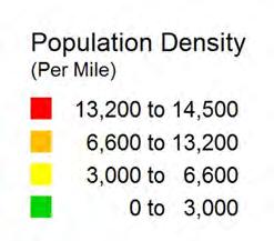
3 Contents 1. Introduction Glossary of Terms Existing Conditions General Conditions The Pedestrian Environment The Bicycling Environment Non-motorized Trip Characteristics Proposed Facilities Non-motorized Network Specific Area Concept Plans Prioritization Proposed Policies and Programs Complete Streets Policy ADA and Transition Plan Safe Routes to Schools Bike Parking Maintenance of Non-motorized Facilities Design Guidelines Road Cross Sections Transitions Between On and Off-Road Bicycle Facilities Modifying Existing Facilities Intersection Design Neighborhood Connectors Bike Route Signs and Wayfinding Bike Boulevards and Neighborhood Greenways Shared Use Paths Commercial Centers Land Use Planning Downtown Streetscape
4 6. Education and Marketing Existing Promotional and Marketing Activities Opportunities and Barriers Public Outreach and Educational Strategies Recommendations Resources Appendix Proposed Michigan Complete Street Resolutions Lansing s Complete Street Ordinance Public Workshop Input
5 1. Introduction The City of East Lansing is poised to become a great city for walking and bicycling. There have been significant improvements to the physical environment in recent history and there are many additional opportunities at hand. This document identifies near-term opportunities to improve the physical environment, guides long-term development and makes recommendations on the policies and programs that promote and support non-motorized transportation. The document is divided into five main segments: Existing Conditions Assesses the state of the existing pedestrian and bicycle facilities. Proposed Facilities Covers the specific long and near term improvement recommendations to the transportation system to establish a non-motorized transportation network. Proposed Policies Describes the support system necessary for a successful pedestrian and bicycle network. Design Guidelines Provides a background on non-motorized transportation issues and defines current best practices for bicycle and pedestrian facility design. Education and Marketing Provides ways to promote non-motorized transportation while providing information on safe bicycling and walking. 1
6 1.1 Glossary of Terms Within this document there are a number of terms that may be unfamiliar to many people. The following is a brief glossary of some of the transportation terms that are found in this document: AASHTO American Association of State Highway & Transportation Officials. Bicycle Quality/Level of Service (Bike Q/LOS) a model for evaluating the perceived safety and comfort of bicycling in a roadway based on conditions within the road (not surrounding land uses) expressed as a letter grade with A being best and F being worst. Bicycle Boulevard- a low-volume and low-speed street that has been optimized for bicycle travel through treatments such as traffic calming and traffic reduction; signage and pavement markings; and intersection crossing treatments. Bike Lane a portion of the roadway designated for bicycle use. Pavement striping and markings sometimes accompanied with signage are used to delineate the lane. Examples can be found on portions of Grand River Ave and Abbot Rd. Bike Route a designation that can be applied to any type of bicycle facility. It is intended as an aid to help bicyclists find their way to a destination where the route is not obvious. Bulb-outs see Curb Extensions. Clear Zones area free of obstructions around roads, Shared-use Paths, and Walkways. Clearance Interval the flashing Don t Walk or flashing Red Hand phase of pedestrian signals. It indicates to pedestrians that they should not begin to cross the street. A correctly timed clearance interval allows a pedestrian who entered the crosswalk during the Walk phase to finish crossing the street at an unhurried pace. Complete Street- streets that are designed and operated to enable safe access for all users. Crossing Islands a raised median within a roadway typically set between opposing directions of traffic that permits pedestrians to cross the roadway in two stages. A crossing island may be located at signalized intersections and at unsignalized crosswalks. These are also known as Refuge Islands. Crosswalk the area of a roadway that connects sidewalks on either side at an intersection of roads (whether marked or not marked) and other locations distinctly indicated for pedestrian crossings by pavement markings. Curb Extensions extending the curb further into the intersections in order to minimize pedestrian crossing distance, also known as Bulb-outs. Dispersed Crossing where pedestrians typically cross the road at numerous points along the roadway, rather than at an officially marked crosswalk. E-Bike a bicycle that is propelled by an electric motor and/or peddling. 2
7 Fines finely crushed gravel 3/8 or smaller. The fines may be loosely applied or bound together with a stabilizing agent. Inside Lane the travel lane adjacent to the center of the road or the Center Turn Lane. Ladder Style Crosswalk a special emphasis crosswalk marking where 1 to 2 wide white pavement markings are placed perpendicular to the direction of a crosswalk to clearly identify the crosswalk. Lateral Separation horizontal distance separating one use from another (pedestrians from cars, for example) or motor vehicles from a fixed obstruction such as a tree. Leading Pedestrian Interval a traffic signal phasing approach where the pedestrian Walk phase precedes the green light going in the same direction by generally 4 to 5 seconds. Level of Service (LOS) a measurement of the motor vehicle flow of a roadway expressed by a letter grade with A being best or free flowing and F being worst or forced flow/heavily congested. Also see Bicycle Level of Service and Pedestrian Level of Service. Long-term Plan reflects the vision of the completed non-motorized system. Some improvements may require the reconstruction of existing roadways, the acquisition of new right-of-way, or significant capital investments. Mid-block Crossings locations that have been identified based on land uses, bus stop locations and the difficulty of crossing the street as probable candidates for Mid-block Crosswalks. Additional studies will need to be completed for each location to determine the ultimate suitability as a crosswalk location and appropriate solution to address the demand to cross the road. Mid-block Crosswalk a crosswalk where motorized vehicles are not controlled by a traffic signal or stop sign. At these locations, pedestrians wait for a gap in traffic to cross the street, motorists are required to yield to a pedestrian who is in the crosswalk (but not if the pedestrian is on the side of the road waiting to cross). MMUTCD Michigan Manual of Uniform Traffic Control Devices. This document is based on the National Manual of Uniform Traffic Control Devices (MUTCD). It specifics how signs, pavement markings and traffic signals are to be used. The current version is the 2005 MMUTCD. It was adopted on August 15, 2005 and is based on the 2003 National MUTCD. Mode-share / Mode split the percent of trips for a particular mode of transportation relative to all trips. A mode-share / mode split may be for a particular type of trip such as home-to-work. Mode distinct types of transportation (cars, bicycles and pedestrians are all different modes of travel). MVC Michigan Vehicle Code, a state law addressing the operation of motor vehicles and other modes of transportation. Near-term Opportunities improvements that may generally be done with minimal changes to existing roadway infrastructure. They include road re-striping projects, paved shoulders, new sidewalks and crossing islands. In general, existing curbs and drainage structures are not changed. 3
8 Neighborhood Greenway a route that utilizes residential streets and short connecting pathways that link destinations such as parks, schools and Shared Use Paths. Neighborhood Greenways share the characteristics of a Bicycle Boulevard but, in addition, provide accommodations for pedestrians and sustainable design elements such as rain gardens. Out-of-Direction Travel travel in an out-of-the-way, undesirable direction. Outside Lane the travel lane closest to the side of the road. Pedestrian Desire Lines preferred pedestrian direction of travel. Pedestrian Quality/Level of Service (Ped. Q/LOS) a model for evaluating the perceived safety and comfort of the pedestrian experience based on conditions within the road ROW (not surrounding land uses) expressed as a letter grade with A being best and F being worst. Refuge Islands see Crossing Islands. Roundabouts yield-based circular intersections that permit continuous travel movement. Shared Roadway bicycles and vehicles share the roadway without any portion of the road specifically designated for the bicycle use. Shared Roadways may have certain undesignated accommodations for bicyclists such as wide lanes, paved shoulders, and/or low speeds. Shared Lane Markings a pavement marking consisting of a bike symbol with a double chevron above, also known as sharrows. These pavement markings are used for on-road bicycle facilities where the right-of-way is too narrow for designated bike lanes. The shared lane markings alerts cars to take caution and allow cyclist to safely travel in these lanes when striping is not possible. They are often used in conjunction with signage. Shared Use Path a wide pathway that is separate from a roadway by an open unpaved space or barrier or located completely away from a roadway. A Shared Use Path is shared by bicyclists and pedestrians. There are numerous sub-types of Shared Use Paths including Sidewalk Bikeways that have unique characteristics and issues. An example of a Shared Use Path would be the Northern Tier Trail. Shy Distance the distance that pedestrians, bicyclists and motorists naturally keep between themselves and a vertical obstruction such as a wall or curb. Sidepath see Sidewalk Bikeways Sidewalk Bikeways a specific type of Shared Use Path that parallels a roadway generally within the road right-of-way. This is also known as a Sidepath. Signalized Crosswalk a crosswalk where motor vehicle and pedestrian movements are controlled by traffic signals. These are most frequently a part of a signalized roadway intersection but a signal may be installed solely to facilitate pedestrians crossings. Speed Table raised area across the road with a flat top to slow traffic. Splitter Islands crossing islands leading up to roundabouts that offer a haven for pedestrians and that guide and slow the flow of traffic. 4
9 UTC Uniform Traffic Code, is a set of laws that can be adopted by municipalities to become local law that address the operation of motor vehicles and other modes of transportation. The UTC is a complementary set of laws to the MVC. Yield Lines a row of triangle shaped pavement markings placed on a roadway to signal to vehicles the appropriate place to yield right-of-way. This is a new pavement marking that is used in conjunction with the new Yield to Pedestrians Here sign in advance of marked crosswalks. 5
10 6

11 2. Existing Conditions The major influences on non-motorized travel may be distilled down to two factors: the physical environment and the social environment. The influence of the physical environment is not limited to the existence of specific facilities such as bike lanes and sidewalks. Just as important as facilities is the underlying urban form. The majority of bicycle and pedestrian trips are for short distances. Even with first-rate facilities, large blocks of homogeneous land uses and spread-out development will inhibit many non-motorized trips. The City of East Lansing and the country as a whole are at a key juncture. Mainstream media has begun to cover the health and economic implications of our land use and transportation infrastructure decisions. Community leaders and citizen activists are calling for a greater emphasis on non-motorized travel. Yet, there is a tremendous physical and institutional legacy to overcome. Topics: 2.1 General Conditions 2.2 Pedestrian Environment 2.3 Bicycling Environment 2.4 Non-Motorized Trip Characteristics 7
12 2.1 General Conditions The City of East Lansing has been developed into three zones with distinct patterns. The Inner Ring of the city, including the Downtown and the area between Grand River Ave and Burcham Dr and Coolidge Rd and Hagadorn Rd. This area consist of high density development where there is a grid street pattern, nearly complete intact sidewalk system and two and three lane primary roads. Pedestrian and bicycle travel is generally easy and comfortable in these areas and there are often numerous route options. The Middle Ring, including the area north of Saginaw St and South of Lake Lansing Rd, consists of moderate density development, with some trail connections and a partially complete sidewalk system. Bicycle and Pedestrian travel is generally comfortable in these areas however there are usually more barriers with minimal route options. The Outer Ring includes the area north of Lake Lansing Rd where many of the new developments have been built. This area consists generally of dispersed land uses that for the most part, are scaled towards automobile use. Few arterial and collector alternatives exist in these areas for bicyclists and pedestrians. Bicycles and pedestrians are directed into corridors with the highest concentration of vehicular traffic. The result is a non-motorized environment that is not favorable to walking and bicycling for everyday transportation. The artificial barriers of the railroad and the four and five-lane arterials tend to fragment the City from a non-motorized standpoint. The City should work to both minimize the impact of the artificial barriers and increase the land use diversity throughout the City. The following maps provide a general summary of the existing conditions in the City of East Lansing: Fig. 2.1A. City Overview Fig. 2.1B. Current Land Use Fig. 2.1C. Population Density Fig. 2.1D. Block Size Analysis Fig. 2.1E. Preliminary Context Areas Fig. 2.1F. Road Jurisdiction Fig. 2.1G. Road Functional Class Fig. 2.1H. Existing Road Cross Section Fig. 2.1I. Average Daily Traffic Volumes Fig. 2.1J. CATA Stops and Services 8
: 3.1 % By Bicycle 22 % Walked 4.")
13 Fig. 2.1A. City Overview Legend Population: currently estimated to be 46,254 Size: Square Miles Journey to Work Data (Based on 2000 Census): 3.1 % By Bicycle 22 % Walked 4.3 % Took Public Transit 29.4 % Non-Car Commute 9


14 Fig. 2.1B. Current Land Use MSU Campus MSU Golf Course Legend 10
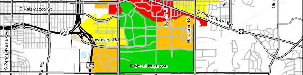
15 Fig. 2.1C. Population Density Legend 11


16 Fig. 2.1D. Block Size Analysis Legend Block size in an excellent measurement of directness of travel. A block is an area that a person cannot pass through. These areas usually do not have any sidewalks, roadways or bikepaths allowing access between two points. One example is an expressway where you may have to go a mile out of your way just to get to the other side. 12


17 Fig. 2.1E. Preliminary Context Areas Legend The city has been divided into three zones based on Land Use, Population Density, Street Layout, and Existing Nonmotorized Facilities. The Inner Ring consists of high density development where there is a complete sidewalk system intact. The Middle Ring consists of moderate density development, with some trail connections and a partially complete sidewalk system. The Outer Ring consists of low density development where there are long segments of shared use trails, but few sidewalks. 13

18 Fig. 2.1F. Road Jurisdiction Legend Roads owned by the state and managed by the Michigan Department of Transportation (MDOT) are shown in red. Any modification to these Trunkline roads must be coordinated with and approved by MDOT. Likewise any roads shown in purple or blue are under the jurisdiction of a county road commission and any modifications to these roads must be coordinated with and approved by the county road commissions. 14

19 Fig. 2.1G. Road Functional Class Legend The National Functional Classifications are referenced in AASHTO guidelines and the guidelines in this document. While the National Functional Classification is intended to define a road hierarchy, substantial variation in road characteristics may be found within the classifications. The actual and projected road characteristics should be the determining factor when selecting appropriate Sidewalk, Buffer and Bike Lane widths. 15

20 Fig. 2.1H. Existing Road Cross Section Legend 16


21 Fig. 2.1I. Average Daily Traffic Volumes Legend Annual Average Daily Traffic (AADT) is a measurement of traffic volumes. These measurements are of total two-way traffic estimated on an average 24-hour period and may vary by season or day of the week. 17

22 Fig. 2.1J. CATA Stops and Services Legend The beginning and ending of a number of nonmotorized trips begins with the public transportation routes and the use of the bus system. 18
23 2.2 The Pedestrian Environment The City of East Lansing has a nearly complete sidewalk system along most major roadways in the built up areas but there remains significant gaps along major roadway in the more suburban parts of town. The quality of the pedestrian experience on these sidewalks varies greatly throughout the City. Some sidewalks have little if any buffer such as a row of trees or parked cars, between the sidewalk and the roadway. This lack of a barrier has been shown to have a significant adverse impact on the quality of the walking experience. Another major issue lies with cross-roadway accommodations. There are significant stretches of the major thoroughfares that provide no means to cross the roadway safely. There are also places where logical crossings are not accommodated. Even where there are marked crosswalks, they are often inadequate. Many times the existing crossings are missing key safety features, making them difficult to cross, especially on high speed multi-lane roadways. Outdated Facilities The City currently has two pedestrian bridges that cross over Saginaw Rd. Both bridges are difficult to navigate across, especially with a bicycle. Pedestrians and bicyclists would be better served by improved at-grade crossings given the number of people who currently choose to cross at grade to avoid the bridges. Until the at-grade crossings are improved, both bridges should be kept in place. The following maps provide a general summary of the existing conditions of pedestrian facilities in the City of East Lansing: Fig. 2.2 A. Existing Sidewalk Quality Fig. 2.2 B. Existing Crosswalk Spacing Analysis Fig. 2.2 C. Existing Road Crossing Difficulty Assessment 19


24 Sidewalk Quality A key factor to a pedestrians comfort level on a sidewalk is the degree of separation from the roadway. Elements such as lawn buffers and vertical elements tend to make a pedestrian feel more separated from the roadway, increasing the pedestrian s level of comfort when on a sidewalk. The sidewalk quality rating system is designed to help identify a pedestrian s level of comfort when on a sidewalk based on the amount of separation from the roadway. The rating system is broken up into five categories A, B, C, D and E. A sidewalk with a rating of A has the best pedestrian comfort level and a sidewalk with a rating of E has the worst pedestrian comfort level. A - Rating Sidewalk is setback from roadway and contains vertical elements such as closely spaced trees and/or light poles. B - Rating Sidewalk is setback from roadway but contains no vertical elements. C - Rating Sidewalk is directly adjacent to the roadway along the curb and has no buffer space or vertical elements. D - Rating No sidewalk facility is built, but the area is physically passable by foot. E - Rating No sidewalk facility is built and the area is not physically passable by foot. Physical barriers such as streams or expressway overpasses usually contribute to this type of situation. 20
 and vertical elements such as trees and light poles increase the pedestrians comfort level. Currently, there is 63% (46.")
25 Fig. 2.2A. Existing Sidewalk Quality Legend A key factor to a pedestrians comfort on a sidewalk is the degree of separation from the roadway. Buffer (lawn extensions) and vertical elements such as trees and light poles increase the pedestrians comfort level. Currently, there is 63% (46.5 Miles) of Existing Sidewalk Coverage Along Primary Roads. 21
 are about ½ a mile long.")
26 Fig. 2.2B. Existing Crosswalk Spacing Analysis Legend Crosswalk spacing is a key factor in directness of travel. Most pedestrian trips for personal business (like walking to the store) are about ½ a mile long. Where there is demand to cross the road and crosswalk spacing is over 1/8 of a mile apart, mid-block crossings are likely to occur. 22

27 Fig. 2.2C. Existing Road Crossing Difficulty Assessment Legend Road crossing difficulty is a measurement of how difficult a person would typically find it to cross a road at an unmarked mid-block crosswalk. It is based on the number of lanes, speed and average daily traffic. Grade Lanes Speed ADT A 2 <30 <5,000 B ,000-10,000 C ,000-15,000 D ,000-20,000 E ,
28 2.3 The Bicycling Environment The approach to handling bicycles in the City is inconsistent and incomplete. In the northern part of town the Northern Tier Trail, a shared use pathway, functions as the main bicycle facility. The downtown area has a few isolated bike lanes. However, bicyclists that choose to take a different route are forced to share the busy arterial road with motorist or ride along the sidewalk when commuting across town. Even together, the on-road and off-road facilities do not make for a complete system and transfers between onroad and off-road facilities are not logical or convenient. In short, there is no cohesive system. The following maps provide a general summary of the existing conditions in the City of East Lansing: Fig. 2.3A. Sidepath Suitability Fig. 2.3B. In-Road Bicycling Quality Assessment Fig. 2.3C. Bike Lane Potential Through 4 to 3 Lane Conversion Fig. 2.3D. Bike Lane Potential Through Lane Narrowing 24

29 Fig. 2.3A. Existing Bicycle Facilities Inventory Legend There are 4.7 Miles of Existing Trail and 13.2 Miles of Existing Bike Lanes. Please note that some existing paved shoulders may not be in desirable condition. Maintenance and repairs would help to improve the quality of some facility. 25


30 Fig. 2.3B. Sidepath Suitability The AASHTO Guide for the Development of Bicycle Facilities generally considers sidewalks undesirable as Shared-use Paths. This is due to the inherent conflicts between bicycles and motorists where a pathway intersects with driveways and roads. Suitable Sidepath location are uninterrupted by driveways and roadways for long distances and provide safe and convenient road crossing opportunities to destination on the other side of the road. Legend A conflict point is a local road or high traffic volume commercial driveway. For this analysis, ten minor/residential driveways were considered equal to one conflict point. 26

31 Fig. 2.3C. In-Road Bicycling Quality Assessment Legend In-road bicycling facilities, improve the quality of the bicycling experience on busy roads. Quality of the in-road bike facilities was based on speed limit and daily traffic volumes. Without Bike Lane With Bike Lane ADT Speed Limit A A 0-5, B A 5,000 10, C B 10,000 15, D C 15,000 20, E C 20,000 25, E D Over 25,

32 Fig. 2.3D. Bike Lane Potential Through 4 to 3 Lane Conversion Legend Four lane roads may be converted into three lane roads with bike lanes. The suitability of the conversion depends on the traffic volume and the delay at signalized intersections. Grade ADT High Potential <15,000 Moderate Potential 15,000-17,500 Marginal Potential 17,500-20,000 Low Potential 20,

33 Fig. 2.3E. Bike Lane Potential Through Lane Narrowing Legend By narrowing the travel lanes of wide roads, bike lanes can easily be added by restriping the road. The ideal lane width for a travel lane is 11 for Principal Arterials; however there are areas where a 10 lane width is appropriate and/or desirable for Minor Arterials and Collectors. Grade High Potential Moderate Potential Marginal Potential Low Potential Lane Min Width 11 + Bike Lane Bike Lane 10 + Bike Lane Too Narrow 29
34 2.4 Non-motorized Trip Characteristics The desire to expand non-motorized transportation choices is generally driven by two factors. First is the goal to accommodate non-motorized transportation given the numerous economic, social, health and environmental benefits. The second goal is often to maximize the potential of the existing transportation system, which could take several forms. This could include shifting trips from single occupancy motor vehicles to bicycling, walking or transit, thus expanding the number of people a corridor can serve. Regardless of the goal, the question is what change in transportation choices will occur if the environment for walking or bicycling is improved? Answering this question precisely is hampered by limited data, sparse research on the subject, and the nuances that go into any transportation choice. What is likely, though, is that the number of people who walk and bicycle will increase when the environment for bicycling and walking is improved. Also, these increases in walking and bicycling do not necessarily have a reciprocal increase in bicycle and pedestrian crashes. Rather, with improved facilities and increases in the number of bicyclists and pedestrians, the crash rates typically decrease as motorists become accustomed to the presence of non-motorized traffic. One of the least understood aspects of transportation planning is the notion of self-selection. It has been demonstrated that individuals who move to an area with a better non-motorized environment will indeed walk and bicycle more 1. What is unknown is how much of that increase is the result of the environment alone vs. how much is the result of an individual s choice to live in a place because its environment supports bicycling and walking. Existing General Non-motorized Mode-split To understand East Lansing s potential to increase the number of people walking and bicycling, it is helpful to look at how East Lansing s current bicycling and walking trends compare to other areas. Then we may be able to gauge approximately how many more people may be enticed to walk and bicycle The mode-split is the overall proportion of trips made by a particular mode of travel. This information is generally determined by surveys. What is apparent is that East Lansing currently has over twice the national average of the percentage of trips taking place by walking and bicycling. When looking at how East Lansing compares to peer cities, its pedestrian commute numbers are already very high. The bicycling numbers though, are on the lower end of the scale. Thus, it is likely that East Lansing would be more likely to increase its percent on non-motorized users though improved bicycle facilities. Pedestrian use will likely go up some, but not as dramatically as bicycle use. 1 Krizek, Kevin J., Residential Relocation and Changes in Urban Travel: Does Neighborhood-Scale Urban Form Matter? Journal of the American Planning Association. Spring, Vol. 69, No. 3, p
35 Table 2.4A Peer City Commute to Work Comparison City Year 2000 Population % Bike % Pedestrian % Public Transit % Total Non-Car East Lansing, MI 46, % 22% 4.39% 29.4% Ann Arbor, MI 114, % 16.5% 6.9% 25.8% Berkeley, CA 102, % 16.0% 19.9% 41.9% Bloomington, IN 69, % 15% 3.0% 20.8% Boulder, CO 94, % 9.7% 8.9% 26% Cambridge, MA 101, % 25.8% 26.5% 56.3% Eugene, OR 137, % 6.4% 5.2% 17.4% Iowa City, IO 62, % 16.0% 7.9% 26.0% Madison, WI 207, % 11.0% 7.4% 21.7% From the US 2000 Census commute to work data as compiled in the online Carfree Census Database found at Bikesatwork.com, compiled by Bikes At Work, Inc., Ames, IA. 31
36 32
37 3. Proposed Facilities Master Plan vs. Corridor Planning The recommendations in this Section represent a Master Plan level evaluation of the suitability of the proposed facilities for the existing conditions. Prior to proceeding with any of the recommendations, a corridor level assessment should be done in order to fully evaluate the feasibility and appropriateness of any roadway modification and/or proposed bicycle or pedestrian facility. Proposed Improvements Outside the City of East Lansing On some of the illustrations, improvements are proposed for areas outside of the limits of the City of East Lansing. These should not be construed as detailed recommendations as they have not received the same level of evaluation as those facilities within the City. Rather, they show diagrammatically how nonmotorized facilities within the City may interact with non-motorized Facilities in the surrounding communities. Some illustrations also show recommendations for improvements on roadways that are not under the jurisdiction of the City of East Lansing. Any modifications to roads owned by the state and managed by the Michigan Department of Transportation (MDOT), roads owned by the county road commissions, or roads owned by a private development, must be coordinated with and approved by the appropriate agency. See Fig 2.1F Road Jurisdiction Map for road ownership. Topics: 3.1 Non-Motorized Transportation Network 3.2 Other Area Concept Plans 3.3 Prioritization 33
38 3.1 Non-Motorized Transportation Network The following maps illustrate the Proposed Non-Motorized Transportation Network: Proposed Non-Motorized Transportation Network Map (this is a large fold out map that may be found in the back cover of the report) Fig. 3.1A. Proposed Bike Lanes on Major Roads Fig. 3.1B. Proposed Bike Routes Fig. 3.1C. Proposed Bike Route Facilities Fig. 3.1D. Proposed Bicycle Boulevard Fig. 3.1E. Proposed Sidewalk/Sidepath Improvements Fig. 3.1F. Proposed Road Crossing Improvements 34

39 Fig. 3.1A. Proposed Bike Lanes on Major Roads Legend Over 38 miles of new Bike Lanes are proposed within the City on Primary Roads. When combined with the over 18 miles of existing Bike Lanes, the City will have approximately 56 miles of Bike Lanes. Routes displayed outside of the cities boundary show conceptual links and need to be coordinated with the appropriate agency. 35

40 Fig. 3.1B. Proposed Bike Routes Legend The bicycle route system provides connectivity between destinations around the city for bicyclists who would not be comfortable bicycling on the primary road system, even if bicycle lanes were present. Routes displayed outside of the cities boundary show conceptual links and need to be coordinated with the appropriate agency. 36


41 Fig. 3.1C. Proposed Bike Route Facilities Legend The proposed bike routes consist of a combination of different bicycle facilities including, pathways, bike lanes, share-use paths, low-volume local roadways. Routes displayed outside of the cities boundary show conceptual links and need to be coordinated with the appropriate agency. 37

42 Fig. 3.1D. Proposed Bicycle Boulevard Legend The proposed bicycle boulevard functions as the premier bike route between the Northern Tier Trail, the downtown and Michigan State University. 38

43 Fig. 3.1E. Sidewalk/Sidepath Improvements Legend Sidewalks along major collector and arterial roads should have a minimum width of 8 with a buffer zone and vertical elements such as trees between the sidewalk and road. 39


44 Fig. 3.1F. Sidewalk Upgrades Legend It is recommended that some of the existing sidewalks be upgraded. Sidewalks that are located right up along the curb need to be relocated away from the roadway and/or vertical elements need to be placed between the sidewalk and the roadway to create a buffer. Sidewalks that are already setback from the roadway should have vertical elements such as trees between the street and the sidewalk to create more separation from the roadway. Bike lanes and parked motor vehicles may also provide addition buffer space especially in urban spaces. Refer to Section 2.2 Sidewalk Quality for more details. The Downtown area may present some challenges. Please refer to Section 3.2 Specific Area Concept Plans for more details. 40

45 Fig. 3.1G. Road Crossing Improvements Legend Road Crossing Improvements are needed in areas where there is a high demand to cross. These areas occur where a bike route crosses a collector or arterial road, a major bus stop or bus shelter is present, there is a long distance between crosswalks, or there is a high demand based on land use and population density. 41
46 3.2 Specific Area Concept Plans The following concept plans were prepared to show how some of the ideas of the Non-motorized Plan may be applied to specific areas. These concept plans should not be taken as completely developed designs. Rather, they are to illustrate a design idea. The areas shown will require separate design studies that may involve a more detailed investigation of the side conditions including public input and the development of alternatives and draft preliminary plans. In addition to the areas shown, there are many other areas that could not be addressed by the scope of this plan but that still warrant further study. Downtown Overview Downtown is a destination to bicyclists and pedestrians as well as an area that must be negotiated through. As Arterials and Collectors come into downtown, motor vehicle speeds are reduced and many more route options become available due to the dense grid pattern of the streets. Downtown also presents the challenge of accommodating some of the highest numbers of pedestrians and bicyclists in the City within a restricted ROW that must also accommodate cars, busses, delivery vehicles and parking. Albert Avenue Due to Grand River Avenue s narrow road width and high traffic volume, Albert Ave has the potential to become the main east-west bike route as an alternative to Grand River Ave. Strategies for this corridor include providing a bike lane between Delta Street and Collingwood Street by reconfiguring the roadway. The following sketches over aerial photographs illustrate the design concept. Fig. 3.2A. Albert Avenue Abbot Road to Grove Street Fig. 3.2B. Albert Avenue Grove Street to M.A.C. Avenue Fig. 3.2C. Albert Avenue M.A.C. to Charles Street Fig. 3.2D. Albert Avenue Charles Street to Division Street Fig. 3.2E. Albert Avenue Division Street to Bailey Street Fig. 3.2F. Albert Avenue Bailey Street to Collingwood Fig. 3.2G. Abbot Road and Grand River Avenue Intersection Fig. 3.2H. M.A.C. Avenue and Grand River Intersection (Alternative A) Fig. 3.2I. M.A.C. Avenue and Grand River Intersection (Alternative B) 42


47 Fig. 3.2A. Albert Avenue- Abbot Road to Grove Street Suggestions: Add Bike Lanes to existing road right-of-way. Add Crossing Island near parking lot entrance on Albert Ave. Add Crossing Island at intersection of Albert Ave and Grove St. 43


48 Fig. 3.2B. Albert Avenue- Grove Street to M.A.C. Avenue Suggestions: Add Bike Lanes to existing road right-of-way by narrowing existing traffic lanes. 44


49 Fig. 3.2C. Albert Ave- M.A.C. Avenue to Charles Street Suggestions: Add Bike Lanes to existing road right-of-way by narrowing the width of the traffic lane and onstreet parking. Enhance corridor with trees and plantings in bump-outs. 45


50 Fig. 3.2D. Albert Avenue- Charles Street to Division Street Suggestions: Add Bike Lanes to existing road right-of-way by narrowing the width of the traffic lane and onstreet parking. Enhance corridor with trees and plantings in bump-outs. 46


51 Fig. 3.2E. Albert Avenue- Division Street to Bailey Street Suggestions: Add Bike Lanes to existing road right-of-way by narrowing the width of the traffic lane and onstreet parking. Enhance corridor with trees and plantings in bump-outs. 47


52 Fig. 3.2F. Albert Avenue- Bailey Street to Collingwood Drive Suggestions: Add Bike Lanes to existing road right-of-way by narrowing the width of the traffic lane. 48


53 Connections Between East Lansing and Michigan State University s Campus Many of the roads that connect the Downtown Area to Campus serve a tremendous number of bicyclist and pedestrians. However, due to narrow rights-of-way, restricted vehicular turning lanes and on-street parking, especially between Albert Ave and Grand River Ave, there are limited opportunities for nonmotorized facilities. In coordination with the MSU Bicycle Facilities Plan, Abbot Road and M.A.C. have been identified as key links to MSU Campus and should be investigated further in regards to their non-motorized potential. Fig. 3.2G. Abbot Road and Grand River Avenue Intersection Abbot Road and Grand River Avenue Intersection The City Center II development plan has been approved for the northwest corner of this intersection. The current proposal calls for six motor vehicle lanes on Abbot Road. It is recommended that bike facilities be included on Abbot Road between Albert Avenue and Grand River Avenue by removing one of those traffic lanes and adding bike lanes. When the City Center II development plan has been completed install a crosswalk on the west side of Abbot Road and Grand River Avenue intersection. While this may cause complications with the signalization of the intersection, the pedestrian volumes that will be generated will warrant a direct crosswalk link between campus and the development. 49
 M.A.C.")


54 Fig. 3.2H. M.A.C. Avenue and Grand River Ave Intersection (Alternative A) M.A.C. Ave and Grand River Ave Intersection (Alternative A) Some strategies for this intersection include: Remove on-street parking on M.A.C. between Albert Ave and Grand River Ave in order to fit bike lanes into existing right-of-way. Remove left-turn lane off of Grand River Ave onto M.A.C. and include a bicycle only signal. Extend crosswalk across Grand River Ave to facilitate bike lane crossing. Enhance the M.A.C. corridor by placing trees (30 on center) and planters on both sides of the streets. An alternative approach to closing the left turn from Grand River to M.A.C. would be to modify the signal timing for the left-turn lane to eliminate conflicts with bicycle traffic. 50


.")
55 Fig. 3.2I. M.A.C. Avenue and Grand River Ave Intersection (Alternative B) M.A.C. Ave and Grand River Ave Intersection (Alternative B) Some strategies for this intersection include: Convert M.A.C. between Grand River Ave and Albert into a pedestrian mall. Limit vehicular access to maintenance and delivery vehicles only during specified times of the day. Enhance M.A.C. corridor with vegetation, pedestrian and bicycle amenities, along with bicycle parking. Due to the amount of pedestrians that would be crossing Grand River Ave, the intersection would still warrant a traffic signal to allow pedestrians to cross. There is enough room to conceptually place a single-lane compact urban roundabout at the intersection of Albert and M.A.C. The clock tower could be moved into the center of the roundabout as a focal point. (A compact urban roundabout could also be incorporated with Alternative A). There are serious implications to the commercial viability of an area when a street is closed to motorized traffic. By removing motorized traffic and spreading out the pedestrian activity that was once focused on narrow sidewalks across an entire road right-of-way, there is typically a significant drop in perceived activity. While there are some successful examples of pedestrian malls around the country, there are many more examples where the malls have failed and the street reopened to motorized traffic. Thus, this alternative should be studied carefully to see if it is indeed a viable option. 51

56 Lake Lansing Overpass The US-127 expressway creates a barrier along the west side of the City allowing for only a few access points to the west. The Lake Lansing Overpass was identified as a major area of concern for pedestrians and bicyclist who want to cross the expressway and access the Eastwood Town Center. Currently, the overpass has no non-motorized facilities and is very difficult to cross as a pedestrian or by bicycle due to heavy traffic and free-flowing ramps. Free-flow ramps pose many dangers to bicyclists and pedestrians. Motor vehicle speeds are high and a lot of merging movements occur in different lanes. When interchanges are reconstructed, all ramps should be brought perpendicular to the roadway to reduce speeds at crosswalk locations. Fig. 3.2J. Lake Lansing Overpass Retro-fit Cross Section Since there are only a few areas that allow access across the expressway, non-motorized facilities should be incorporated into the Lake Lansing Overpass in the near term. The existing bridge deck provides the potential to incorporate bike lanes and sidewalks by removing the center median and reducing the travel lanes to 11 wide. Also, when the interchange is reconstructed all ramps should be brought perpendicular to the roadway to provide a safer crossing environment for pedestrians and bicycles. Other Areas to Investigate Further The following is a list of issues that could not be addressed in the scope of this plan and further research and development is recommended. Evaluate potential for roundabouts at the following intersections: Grand River Ave at Hagadorn, Burcham Dr at Hagadorn, M.A.C at Albert Ave, and Park Lake Rd at Burcham Dr. Evaluate potential for pork chop crossing islands at the following intersections: Saginaw St and Harrison Rd, Saginaw St and Abbot Rd, Hagadorn Rd and Grand River Ave. A more detailed study of the Downtown Area is recommended to evaluate the potential for compact urban roundabouts, additional vegetation, bicycle parking and other non-motorized facilities and amenities. 52
57 3.3 Prioritization The proposed improvements fall into two general categories, near-term opportunities and long-term improvements. Near-term opportunities include improvements that may be accomplished by relatively modest changes to the existing road system and the addition of relatively short off-road trail segments. Long-term improvements are projects that will be implemented with new development or the reconstruction of existing improvements. Near Term Opportunities The sum of the near-term opportunities constitute a significant undertaking that will likely take 10 to 20 years to completely implement depending on available funds. Thus, the near-term opportunities have been grouped into first, second and third priorities to help guide implementation. In general, near-term opportunities: May generally be done within the existing infrastructure and for the most part curbs and drainage structures are not changed. May be implemented as soon as funding is available and design work completed. Include both relatively inexpensive road modifications such as 4 to 3 lane conversions and moderately expensive improvements such as crossing islands. Are in some cases design compromises, where the widths of bike lanes, motor vehicle lanes, buffers, and sidewalks are less than the ideal desired widths in order to fit within the existing curb lines and right-of-ways. May in many cases be the same as the ultimate long-term solution as existing development and right-of-way restrictions limit the design options. May be done independently or as a part of resurfacing, restoration, rehabilitation or minor widening projects. In general, if a road is to be resurfaced within the next few years, any road restriping should be incorporated in the resurfacing project. Long Term Improvements The costs to undertake these non-motorized projects independently of a road reconstruction project would be significant. Thus, in order to maximize the impact of finite resources, the long-term improvements are expected to be implemented as a road is completely reconstructed (not just resurfaced). In general, longterm improvements: Are generally implemented when a new road is built or an existing road is completely reconstructed. Reconstruction projects typically include new curb and gutter as well as storm water systems. Generally require that a road be widened to accommodate the minimal lane width requirements for all users and may require additional rights-of-way. Strive to meet the minimum desired widths for bike lanes, motor vehicle lanes, buffers, and sidewalks to the extent that it is practical given the project s context. The distinction between the near-term opportunities and the long-term improvements can sometimes be obscure. For many roadways, the near-term opportunities and long-term improvements will be the same. The difference will be primarily qualitative (width of sidewalks, buffers, bike lanes and motor vehicle lanes). This report does not define the ideal long-term cross section for every primary road in the City. Rather it defines what improvements should be included and provides guidelines for a wide variety of road and right-of-way scenarios. 53

58 Fig. 3.3A. Near-term Opportunities First Priority Legend The first priority focuses on the most critical connections and routes that need to be completed. The most critical midblock road crossings and bike routes are also identified. 54
59 Near-term Opportunities First Priority The first priority includes the most critical connections and routes within the city. The key projects are identified with the project scope and pre-implementation steps called out. For some projects, there is both an initial project scope and a secondary project scope. The initial project scope identifies opportunities to get something implemented quickly and for less cost than the secondary project scope. The initial project scope may be skipped, if funding for the secondary project scope is secured and the project seems to be on-track for implementation. Albert Avenue This is a key east-west link across the downtown and has the potential to become the premier alternative route to Grand River Ave. Initial Project Scope: Add bike lanes on Albert Ave between Abbot Rd and Collingwood Dr Add shared-use arrows to Albert Ave between Collingwood Dr and Milford St Add bike lanes to Albert Ave between Milford St and Hagadorn Rd Key Pre-Implementation Steps: Prepare pavement marking and sign plan for Albert Ave Secondary Project Scope: Add crossing islands and bump-out islands to increase visibility and safety Add traffic calming devices, such as roundabouts Add plantings Key Pre-Implementation Steps: Conduct a survey of Albert Ave Conduct a corridor study of Albert Ave, this may be part of a Downtown study Design project and prepare construction documents 55
60 M.A.C. Avenue This corridor has been identified as a key link between the City of East Lansing and M.S.U. Campus. Initial Project Scope: Add bike lanes to M.A.C. by removing some of the on-street parking and restriping Key Pre-Implementation Steps: Prepare pavement marking and sign plan for M.A.C. Ave Secondary Project Scope: Incorporate bump-out islands at pedestrian crossings and intersections to increase visibility along segment between Burcham Drive and Albert Ave. Improve segment between Albert and Grand River. Improve Grand River crossing. Key Pre-Implementation Steps: Survey project area A corridor study of M.A.C. to evaluate the alternatives. This may be part of a downtown study Design project and prepare construction documents Acquire permits 56
61 Collingwood Drive This corridor has been identified as a key link between the City of East Lansing and M.S.U. Campus. Initial Project Scope: Add bike lanes to Collingwood Drive between Albert Avenue and Grand River Avenue by restriping. Sign bike route Key Pre-Implementation Steps: Prepare pavement marking and sign plan for Collingwood Ave Secondary Project Scope: Incorporate traffic calming and bicycle boulevard design elements Improve Grand River crossing. Key Pre-Implementation Steps: Survey project area A corridor study needs to take place before any redevelopment can occur. This may be part of a downtown study. Design project and prepare construction documents 57
62 Bicycle Boulevard This is a priority bicycle route between the Northern Tier Trail and the Downtown. Initial Project Scope: Add bike lanes to Old Hickory Lane and Hitchingpost Rd through lane narrowing and restriping Sign bike route Key Pre-Implementation Steps: Prepare pavement marking and sign plan for Old Hickory Lane and Hitchingpost Rd Secondary Project Scope: Incorporate traffic calming and bicycle boulevard design elements Incorporate sustainable design elements Key Pre-Implementation Steps: A corridor study needs to take place before any redevelopment can occur. Coordinate with M.S.U. to connect to the Red Cedar Greenway on Campus. Survey project area Design project and prepare construction documents Acquire permits 58
63 Michigan Ave This is a priority bicycle route between the Northern Tier Trail and the Downtown. Project Scope: Add bike lanes to Michigan Ave between Grand River and Harrison Road through 3 to 2 lane conversion for west-bound traffic and lane narrowing for east-bound traffic. Add bike lanes to Michigan Ave west of Harrison Road through 6 to 4 lane boulevard conversion, thus removing one lane in each direction. Key Pre-Implementation Steps: Collaborate with MDOT to evaluate lane reduction and prepare pavement markings plan for Michigan Ave. Lake Lansing Overpass This is a key connection across the expressway. Initial Project Scope: Retrofit bridge to include bike lanes and sidewalks in each direction. Key Pre-Implementation Steps: Collaborate with MDOT to evaluate adding bike lanes and sidewalks to overpass Design project and prepare construction documents Acquire permits Secondary Project Scope: Evaluate changing the free-flowing ramps to intersect Lake Lansing Road at 90 degree angles when reconstruction of the overpass occurs Key Pre-Implementation Steps: Prepare a corridor study in collaboration with MDOT, Ingham County Road Commission and Lansing Township. 59
64 Critical Midblock Road Crossings These crossings are located on major roads where a bicycle boulevard intersects the roadway or pedestrians currently have to go a significant distance out of their way just to cross the road. Project Scope: Add mid-block crossing improvements on Saginaw Street, Michigan Ave and Grand River. Key Pre-Implementation Steps: Collaborate with MDOT to determine most appropriate crossing improvement types Survey project area Design project and prepare construction documents Acquire permits 60

65 Fig. 3.3B. Near-term Opportunities - Second Priority Legend The second phase includes bike lanes and pathways that can be implemented in the nearterm. It also includes the remaining Crossing Improvements. 61
66 Near-term Opportunities - Second Priority The second priority includes trail extensions, near-term bike lanes, and crossing improvements. The trail extensions and road crossings are important for the development of the bike route system. The bike lanes that are identified do not require any reconstruction and only minor changes such as restriping the road are necessary. Near-Term Bike Lanes The bike lanes that are identified do not require any reconstruction and can be implemented within the existing right-of-way. Project Scope: Add bike lane to Coolidge Road between Saginaw St and Lake Lansing Rd. Initial recommendation is to achieve this through a 4 to 3 Lane Conversion, as this would permit the use of crossing islands for the numerous recommendations. If it is desirable to maintain 4 lanes from a traffic management standpoint then bike lanes may be achieved through lane narrowing, but this approach may entail less satisfactory and/or more expensive road crossing improvements. Add bike lanes to Harrison Road between Saginaw St and Lake Lansing Rd through a 4 to 3 lane conversion Add bike lanes to Haslett Rd between Hagadorn Rd and Park Lake Rd through a 4 to 3 lane conversion Add bike lanes to Alton Rd between Saginaw St and Burcham Dr through a 2 to 1 lane conversion Add bike lanes to Saginaw St between Coolidge and Abbot Rd through lane narrowing Add bike lanes to Abbey Rd between Coolidge Rd and Marfitt Rd through lane narrowing Add bike lanes to Marfitt Rd between Abbey Rd and Lake Lansing Rd through lane narrowing Add bike lanes through Frandor Key Pre-Implementation Steps: Collaborate with MDOT to evaluate adding bike lanes to Saginaw St Collaborate with the City of Lansing and Frandor to create a non-motorized connection for bicycle and pedestrians into and across Frandor. Perform project surveys as necessary. Prepare pavement markings plans 62
67 Trail Extensions Trail extensions are proposed in the following parks, schools and city owned property. There are also a few areas where easements from private property owners will be required. Project Scope: Add pathway in Hawks Nest Park Add pathway in Albert A. White Memorial Park Add pathway in Abbey Road Park Add pathway in Henry Fine Park Add pathway in Patriarche Park Add pathway in Burcham Park Add connection through City Parking Lot between Abbot Rd and Evergreen Ave. Add pathway in Water Easement at the end of King Ct connecting to Berkshire Ln. Add connection from Northern Tier Trail to Tamarisk Neighborhood through existing right-ofway (Bridge may be required). Add connection from Northern Tier Trail to Colorado Dr through Harrison Meadow Park Add pathway in Ranney Park (City of Lansing) Add pathway in Burcham Hills (Private Owner) Add a pathway along the undeveloped corridor between Coolidge Rd and Harrison Rd (Consumers Energy Company Property) Add pathway at MacDonald Middle School (East Lansing School District) Add pathway at Marble Elementary School (East Lansing School District) Key Pre-Implementation Steps: Coordinate with East Lansing Public Schools to develop trails through school property. Use Consumer s Energy Company License application process to locate trails and transmission line right-of-way or company property. Coordinate with the City of Lansing to develop trail through Ranney Park. Coordinate with Burcham Hills to develop trail through their property. Perform surveys as neccessary Hold public workshops on pathway location and design Design projects and prepare construction documents Acquire permits 63
68 Sidewalk Beech St between Gunson St and Hagadorn Rd needs a pedestrian facility to accommodate students walking to school. Due to the limited right-of-way on this segment of road, a sidewalk along the south side of the street is recommended. Project Scope: Add sidewalk to south side of Beech St between Gunson St and Hagadorn Rd by narrowing the existing traffic lanes. Key Pre-Implementation Steps: Survey Design project and prepare construction documents Acquire permits Road Crossing Improvements The remaining road crossing improvements need to be constructed to help support the bike route system. Project Scope: Evaluate placing crossing improvements on Burcham Dr, Hagadorn Rd, Coolidge Rd, Harrison Rd, Grand River Ave, Abbot Rd, Haslett Rd, and Lake Lansing Rd to improve visibility and help reduce traffic speeds. Key Pre-Implementation Steps: Additional study of each site needs to be developed before any implementation occurs Collaborate with the appropriate road agencies to discuss adding crossing improvements to their roads Survey Design project and prepare construction documents Acquire permits 64

69 Fig. 3.3C. Near-term Opportunities Third Priority Legend The third phase focuses on the local road bike route system, enhancing it with a way finding system and realigning stop and yield signs. 65
70 Near-term Opportunities Third Priority The third priority addresses the implementation elements that are required for the proposed bike route system. Bike Routes It is critical that all road crossing improvements identified in Priorities 1 and 2 are implemented before signage and routes are developed. Initial Project Scope: Sign the bike route system Key Pre-Implementation Steps Determine ways to relocate stops and yield signs along the route to establish bike route priority Prepare bike route sign package. Secondary Project Scope: Incorporate bump-out islands at pedestrian crossings and intersections to increase visibility along this corridor Evaluate ways to incorporate traffic calming and bicycle boulevard design elements. Key Pre-Implementation Steps: Contact Private Owner to gain access from Old Canton Lane into the backside of the Shopping Center at the corner of Grand River Ave and Hagadorn. Collaborate with Owners of Private Roads in the development between Coolidge Rd, Coleman Rd, Chandler Rd and State Rd. Survey necessary areas Design and prepare construction documents Acquire permits 66


71 Fig. 3.3D. Long-term Improvements Legend The fourth phase includes areas that cannot be implemented in the near-term and require major redevelopment or reconstruction. 67
72 Long-term Improvements The long-term improvements are projects that require major redevelopment or reconstruction. These are major capital improvements that will be implemented over an extended period of time as funding becomes available or integrated into other major construction projects Trail Extension The bike lanes that are identified require reconstruction and cannot be implemented within the existing roadway. Project Scope: Add bike lanes to E State Rd Add bike lanes to S Chandler Rd Add bike lanes to E Lake Lansing Rd Add bike lanes to Abbot Rd Add bike lanes to Hagadorn Rd Add bike lanes to Grand River Ave east of Michigan Ave Add bike lanes to Bogue St Add bike lanes to Harrison Rd between Grand River Ave and Saginaw St Add bike lanes to Harrison Rd south of Michigan Ave Add bike lanes to Trowbridge Rd Add bike lanes to Park Lane Rd Add bike lanes to Coolidge Rd between Lake Lansing Rd and Abbey Rd Add bike lanes to West Rd between Lake Lansing Rd and the County Line, extending to the existing bike lanes on the north end of West Rd Add bike lanes to Saginaw St between Abbot Rd and Alton Rd Add bike lanes to Haslett Rd between Saginaw St and Hagadorn Rd Add bike lanes to future extension of Coleman Road west along old railroad corridor. Key Pre-Implementation Steps: Collaborate with the appropriate road agency on the design of the road corridors Survey project area Design project and prepare construction documents Acquire permits 68
73 Trail Extension The following conceptual trail extensions need to be coordinated with future development in that area. Project Scope: Add a pathway to the future development through the Northeast area of city where there are currently sod farms. Add pathway through the future development of the Michigan State Police Headquarters, located at the corner of Kalamazoo St and Harrison Rd Key Pre-Implementation Steps: Coordinate with the developer to discuss trail extensions through their property Survey as necessary Design and prepare construction documents Acquire permits 69


74 Fig. 3.3E. Priority Overview Legend 70
75 4. Proposed Policies and Programs These policies and programs provide the institutional support for the non-motorized system. They provide the necessary support systems for the proposed physical system. They also provide a framework within which new issues related to non-motorized transportation may be addressed. Topics: 4.1 Compete Streets Policy 4.2 ADA Compliance Issues 4.3 Safe Routes to School 4.4 Bike Parking 4.5 Maintenance of Non-motorized Facilities Prioritization Process for Policy Recommendations: The method of prioritization for the following policy recommendations was made by identifying the relative importance of that policy and the ease with which it could be implemented within a given time frame. Some policy items could readily be achievable within a year. Others, due to the process required to put together the necessary items needed to fully implement the policy, may take three to five years. These policies are flexible enough that they can be rearranged as priorities and available resources change. Roles and Responsibilities in Implementing Policy Recommendations: The policy recommendations have not been assigned to particular departments or staff positions in the City. One of the first tasks in implementing these recommendations would be assigning each policy recommendation to a responsible party. 71
76 4.1 Complete Streets Policy States, regions, counties and cities around the country have used various complete street policies to unambiguously endorse and define their support for non-motorized transportation. Complete streets are planned, designed, operated and maintained such that all users may safely, comfortably and conveniently move along and across streets throughout a community. The complete streets concept recognizes that streets serve multiple purposes and that a community s roadways must be designed such that they balance the needs of all of the transportation users. Complete streets are key to creating healthy, active communities and establishing safe routes to school. There has been a concerted move towards complete streets in the United States since the 1990 s. Recently, the US Department of Transportation issued a Policy Statement on Complete Streets. It indicated that it is the DOT s policy to incorporate safe and convenient walking and bicycling facilities into transportation projects. It also noted that it is every transportation agency s responsibility to improve conditions and opportunities for walking and bicycling and integrate improvements for such into the transportation system. It also encourages transportation agencies to go beyond the minimum standards. Part of the DOT recommended actions include: Providing accommodations on new, rehabilitated and limited-access bridges Collecting data, setting targets and tracking progress Maintaining sidewalks and pathways the same way roads are maintained Improving facilities as part of maintenance projects In short the policy states that walking and bicycling should be considered equals with other transportation modes. In the fall of 2010, The State of Michigan adopted Complete Streets legislation. The complete streets legislation was in the form of two bills. The first bill revised Act 51, addressing transportation issues. The second bill revised Act 33 that addresses planning issues. Act 51 Revision Highlights: Requires interjurisdictional consultation on non-motorized projects and 5-year plans Use of established best practices Directs MDOT to draft and adopt a complete streets policy as well as develop model polices for local agencies Directs MDOT to advise local agencies on non-motorized issues Enables interjurisdictional agreements for maintenance Act 33 Revision Highlights: Expands the definition of streets to include all legal users Expands elements that may be included in a master plan to include all forms of transportation Specifies that transportation improvements be appropriate to their context Specifies cooperation with road 72
77 National Complete Streets Coalition Model Since the FHWA model was developed, The National Complete Streets Coalition has taken the idea further and identified ten elements of a comprehensive Complete Streets policy: 1. A vision for how and why the community wants to complete its streets. Specifies that all users including pedestrians, bicyclists and transit passengers of all ages and abilities, as well as trucks, buses and automobiles. 2. Specifies that all users includes pedestrians, bicyclists and transit passengers of all ages and abilities; as well as trucks, buses and automobiles. 3. Encourages street connectivity and aims to create a comprehensive, integrated, connected network for all modes. 4. Is adoptable by all agencies to cover all roads. 5. Applies to both new and retrofit projects, including design, planning, maintenance, and operations, for the entire right of way. 6. Makes any exceptions specific and sets a clear procedure that requires high-level approval of exceptions. 7. Directs the use of the latest and best design standards while recognizing the need for flexibility in balancing user needs. 8. Directs that complete streets solutions will complement the context of the community. 9. Establishes performance standards with measurable outcomes. 10. Includes specific next steps for implementation of the policy. Numerous local communities have already adopted complete streets resolutions or ordinances. In 2010, the City of East Lansing drafted a complete streets ordinance that addresses how the city will integrate complete streets into its plans, policies and programs. The city is currently reviewing the draft ordinance. The adoption of this plan addresses many of the elements. 73
78 Policy Recommendations for Complete Streets: Within One Year: Adopt the Non-motorized Transportation Plan Adopt the draft Complete Streets Policy that address the ten key elements as defined by the National Complete Streets Coalition and that clearly defines the responsible authorities Develop 5-year non-motorized improvement plan (based on the Non-Motorized Master Plan) Meet with MDOT, Clinton and Ingham County Road Commission and surrounding jurisdictions to review 5-year plan as it relates to facilities under their jurisdiction Within Three Years: Implement recommended operations procedures Establish performance measures Begin data collection Build a reference library of current best practices Establish professional staff training program Identify City standard plans and details that need to be revised Begin revising standard plans and details Within Five Years: Complete update of standard plans and details Evaluate progress 74
79 4.2 ADA and Transition Plan Title II of the Americans with Disabilities Act of 1990 (ADA) requires local governments to make their activities, programs and services accessible to persons with disabilities. In the area of non-motorized transportation, the City is required to use accessible design standards for newly constructed and reconstructed sidewalks and shared use paths to the maximum extent feasible and make altered facilities readily accessible. In addition, the City is required to bring non-compliant curb ramps into compliance throughout the City as part of a transition plan. Four recent publications address accessibility of non-motorized facilities. They are: 1. Designing Sidewalks and Trails for Access Part 2 Best Practices Design Guide (FHWA, Publication # FHWA-EP ) 2. Building a True Community Final Report of the Public Rights-of-Way Access Advisory Committee, November, 2005 (Public Rights-of-Way Access Advisory Committee) 3. Draft Guidelines for Accessible Rights-of-Way, November 23, 2005 (FHWA, Pub. # FHWA-SA , based in part on the preceding publication) 4. Accessible Public Rights-of-Way, Planning and Designing for Alternations, July 2007 (Public Rights-of-Way Access Advisory Committee) Together these documents define current best practices for accommodating pedestrians with disabilities for sidewalks and shared-use paths, intersections, crosswalks, and signalization. Until public rights-ofway standards are adopted by the Department of Justice and the U.S. Department of Transportation, the DOT has identified the 2005 draft PROWAG as the current best practice in accessible pedestrian design. Transition Plan Title II requires that public entities with 50 or more employees create and regularly update an ADA Transition Plan and make this plan available to the public. The transition plan should at a minimum identify physical barriers and provide a detailed outline to remove those barriers. An ADA coordinator must be designated to coordinate compliance efforts. The following outlines the key elements of a transition plan. Identification of Physical Barriers The identification of physical barriers may take place on a number of levels: Complaint-Based At the most basic level, there should be a process in place for citizens to register a complaint and for that complaint to receive appropriate evaluation and action. Inventory Based More commonly, existing facilities receive a base line documentation that may be accomplished with simple tools such as a smart level, digital camera and a standard recording form. For example, the inventory of sidewalk curb ramps would identify issues such as the presence of a ramp, ramp slope and cross slope and the presence, type and condition of a detectable warning strip. The goal of this inventory is to identify the geographic location, type and severity of barriers. Often this survey would be done using a Global Positioning System and the data stored in a Geographic Information System. This inventory would be completed over time with the most heavily traveled areas completed first and then covering other, less traveled areas in a systematic approach. 75
80 Survey Based In a few cases where there is a high degree of controversy regarding a specific area or facility type, trained surveyors will take detailed field measurements and elevations of the facilities and translate them into survey drawings. This is by far the most expensive identification approach but may be appropriate if construction to remedy the solution is considered likely to occur in the near future. Outline of Methods to Remove Barriers A systematic approach for removing barriers should be established. New and Altered Facilities Policy There should be in place a policy for how accessibility is achieved for new construction and alterations. This should include addressing how areas adjacent to new construction or alternation projects may be incorporated into a project. For example, when a new construction or alternation project is undertaken, the inventory of physical barriers for the immediate surrounding areas should be consulted to see if limited targeted improvements in adjacent areas would make a much larger area accessible. If so, those changes should be incorporated into the project. Prioritization of Routes As it will be many years before new construction and alterations will provide accessible routes along all public right-of-ways, a process should be established to identify which routes should be upgraded independent of new or altered facilities. This would be based on the inventory of the physical barriers, citizen complaints and relative demand. This way, key routes such as those in the downtown, near schools and public buildings may be targeted improvements independently of new construction or alternation projects. Schedule for Implementation After the routes are prioritized, general costs of removing the barriers should be determined. Then using those costs, the removal of barriers should be integrated into the city s capital improvement plan. Policy Recommendations for ADA Compliance: Within One Year: Establish an interim transition complaint based transition plan. Designate an ADA coordinator. Within Three Years: Have an inventory based transition plan in place. Integrate the transition plan into the capital improvement plan. Within Five Years: Complete the inventory of physical barriers. Have made substantial progress in removing barriers in the most highly traveled corridors. 76
81 4.3 Safe Routes to Schools The challenges to getting more children to walk and or bike to school are significant. Approximately half of all children in the United States are driven to school in a private vehicle and only 13% walk or bike to school. 1 The number of children walking or biking to school has dropped 37% in 20 years. 2 This drop in the number of children walking and bicycling to school can be attributed to many factors that have changed over the past 20 years: Increase in availability of before and after-school programs. Increase in the number of schools of choice, private schools and charter schools. Increase in the number of grade-based elementary schools. Increase in the number of children bused to school who live within walking distance due to real or perceived safety concerns. Fewer children living in each home. These factors have combined to simultaneously reduce the total number of children who attend their neighborhood school, reduce the number of kids who walk and spread out the times children arrive at and depart from school. The result is a loss of the critical mass of children walking to school and the perceived safety in numbers. These factors are combined with the fact that there is also an increase in the number of two-wage earner families where both wage-earners are leaving for work in the morning. This makes dropping a child off at school on the way to work the easy and seemingly logical choice. We have now entered a period in time where choosing to have a child walk to school is considered a political statement or some act tantamount to child neglect rather than the default choice. While the challenges to getting more children to walk and bicycle to school are significant, the consequences of doing nothing are even more challenging. The Center for Disease Control states that 13% of children in the United States are overweight, and the number of overweight teens has tripled since Many children in the United States do not get the hour of daily physical activity recommended by the Surgeon General. Decreased participation in physical activities, and fewer students walking or riding their bikes to school may be contributing to the rise in childhood obesity. For many children who live very far away from school, walking or biking is not a feasible option. However, the CDC estimates that only 31% of the children living a mile away or less walk or bike to school. Often times, schools and their surrounding areas lack safe road crossings, preventing children from having safe access to school on foot. Parents and caregivers cite perceived traffic danger as the second most common barrier to children walking and biking to school, preventing as many as 20 million children from walking or biking to school nationwide. 3 The amount of people driving their children to school in private automobiles not only represents a missed opportunity for physical activity, but also increases traffic congestion and puts a huge strain on existing road systems during peak travel times. In one city examined, 20-25% of morning traffic consisted of students being driven to school and 50% percent of children hit near schools were hit by parents of other students. 4 1 Center for Disease Control. MMWR Weekly. August 16, (32); Michigan Governor s Council on Physical Fitness, Health and Sports. 3 Center for Disease Control. MMWR Weekly. August 16, (32); Center for Disease Control,
82 In an effort to reverse these alarming trends, the CDC announced a national health objective to increase the proportion of walking and biking trips to school for children living a mile or less from 31% to 50% by the year Communities, school groups, and local officials all over the country are responding to this challenge by mobilizing children to walk to school, addressing traffic safety concerns, mapping safe routes to school, and by measuring and taking account of their neighborhoods walkability. Michigan s Safe Routes to School (SR2S) Michigan has a model Safe Routes to School program that is managed by the Michigan Department of Transportation (MDOT) in partnership with the Michigan Fitness Foundation which provides training, administrative and technical support. The center for Michigan SR2S program s website has extensive information on how a school may start a SR2S program. The website describes the six step SR2S planning process: 1. Register a school on the website. 2. Designate a SR2S coordinator. 3. Establish a SR2S team comprised of school officials, students and their parents and local officials. 4. Survey the students and parents to understand the issues. 5. Perform a safety assessment of the physical environment. 6. Develop an action plan. Beyond describing the planning process Michigan s SR2S program offers technical assistance and support to schools. These include: A SR2S Handbook with a wealth of information including templates and forms useful in implementing a program. Providing training programs. Walk to School Day kits. Newsletters. Direct technical assistance. The City s Role in SR2S Programs The City of East Lansing is a key partner in any Safe Routes to School Program. SR2S school teams typically include a local law enforcement official or officer and a representative from the local road authority. These officials provide the technical expertise to help the team implement some of the programs and physical improvements. A typical SR2S program addresses issues such as the education of parents and students as well as improvements to the physical conditions on the school grounds. But much of the SR2S physical improvements take place on facilities outside of the school s jurisdiction and must be undertaken in partnership. Likewise the city s non-motorized network identifies key routes that transverse school grounds. Thus, both entities must work together in order to meet their shared goals. East Lansing s transportation policy should include a system of accountability for responding to and remedying safety concerns along children s routes to school. The City should work with the East Lansing 78
83 Public School District to evaluate how best to spend transportation dollars, looking at bussing, facility improvements, and the addition of adult supervisors for children walking to school. Ensuring safety in the school zone must be a combined effort of traffic engineers, local officials, law enforcement, school officials, parents and children. In addition to promotional and educational programs, a variety of roadway improvements can be used to increase safety in school zones and for children on their routes to school. Some important safety design guidelines for school zones include 1 : Reduced speed zones. Marked crosswalks. Signalized crossings at intersections with pedestrian activation. Pedestrian crossing islands and bulb outs where needed. Special crosswalk striping, painted according to state standards, and School Crossing signage where appropriate. Police enforcement of yielding and speeding in school zones, and the utilization of adult crossing guards at difficult intersections can also increase safety in the school zone. Individual school policies as well as district wide policies should be evaluated to make sure that they promote bicycling and walking. Currently some elementary schools in the City of East Lansing restrict bicycling to school. In conclusion, increasing the number of children who are able to safely walk and bike to school is part of a national goal that will address childhood obesity, enhance neighborhood walkability, and help alleviate traffic congestion problems. Key Programs to Continue for School Transportation The City of East Lansing has some good existing policies and programs that support the non-motorized system. The following policies and programs should be reinforced and continued. The City of East Lansing and the East Lansing Public Schools currently have an active Safe Routes Committee at three elementary schools (Marble, Glencairn and Pinecrest). There is also a Safe Routes Action Plan in place for these schools. These programs should be continued. 1 San Diego s Regional Planning Agency. Model Guidelines for the San Diego Region. April p
84 Policy Recommendations for School Transportation The City of East Lansing and the East Lansing School District should jointly explore the following options. Within One Year: The City should work within the Safe Routes to School Action Plan to ensure that within school safety zones, all safety design guidelines are in place and current with national safety guidelines. The City and the School District should develop a cost-share policy for the construction and maintenance on pathways that are part of the Bike Route System and traverse school property. The City and School District should develop a strategic implementation plan for pathways and trails that are part of the Bike Route System that traverse school property. Within Three Years: The City and School District should continue to enhance a system of accountability for responding to and correcting safety concerns along routes to school and other problems identified through these programs. The City should continue to promote and initiate with the school system and parents Walk-to- School Day events, walking school bus programs, Safe Routes to School programs, and walkability audits in conjunction with the state-wide program. East Lansing Public Schools should perform formal evaluations of how pedestrians and bicyclists are accommodated to all school grounds and prepare action plans to address deficiencies. East Lansing Public Schools should encourage walking and bicycling to school as a part of the physical education and well being of the students. The City should work with the School District to eliminate the need for all Safety Bussing by remedying the hazards that currently warrant the safety bussing. Within Five Years: East Lansing Public Schools should evaluate all individual school and district wide policies regarding bicycling to school and amend policies that discourage bicycling. Encourage residential infill projects within walking distance of schools. 80

85 4.4 Bike Parking The lack of a secure parking space discourages many people from using their bikes for basic transportation. When sufficient bike parking is not provided, theft becomes a concern and it leads to bikes being locked up to sign post, benches and other street furniture. When bicycles are parked in these spaces, they often disrupt pedestrian flow because the bikes impede the walkway. Bicycles also get impounded by local enforcement when parked in these areas causing an even greater deterrent to bicycle use. Bicycle parking needs to be visible, accessible, plentiful and convenient. If any of these criteria are not met, there is a good chance cyclist will not use the facilities and will park their bike wherever they feel it will be safest. Definition of a Bicycle Parking Space- A bicycle parking space is an area two feet by six feet or the area occupied by a bicycle when using a bicycle parking device as designed. Short-Term Bicycle Parking - Short-term bicycle parking is defined as a rack to which the frame and at least one wheel can be secured with a user-provided U-lock or padlock and cable. This type of parking is appropriate for short term parking at locations such as shopping areas, libraries, restaurants and other places where typical parking duration is less than two hours. Long-Term Bicycle Parking- A long-term bicycle parking space is defined as protecting the entire bicycle and its components from inclement weather and theft or vandalism. It is to be located where it will serve the needs of cyclist who need to leave their bicycles unattended for extended periods of time, such as employees, tenants or residents. Uncovered Bicycle Racks Uncovered Bicycle Racks are the primary bike parking approach for areas where people are expected to park their bikes for only a few hours. Design-Generally, bicycle racks of the inverted U design are considered the best models. Alternative designs may be considered for special situations, although they should function similar to the inverted U design, providing at least two contact points for a bicycle and be a shape and size that would permit locking of a bicycle through the frame and one wheel with a standard U-Lock or cable. Location- Bicycle racks should be located on every city block where there is retail within a commercial district. The hoops should be placed on a hard surface with ample lighting and high visibility (e.g. in front of a store window) to discourage theft and vandalism. Racks should be placed to avoid conflicts with pedestrians, usually installed near the curb and away from building entrances and crosswalks. When racks are installed in public spaces there needs to be at least 5 feet of clear sidewalk space in order to allow for pedestrian flow. Covered Bicycle Parking Covered Bike Parking is desirable for both long-term and short-term bicycle storage. Basic bicycle racks should be placed under an overhang whenever possible, and specific covered bicycle parking should be created when needed. Covered Bicycle Parking should be available in areas where bikes are kept for an extended period of time, such as apartment buildings or at large commercial centers where employees and customers will utilize the covered spaces. 81

86 Design- The covering for bicycle parking will vary depending on the location. In addition to a roof, complete or partial side enclosures should be provided to minimize exposure to windblown rain and snow. The design of the racks is the same as for the basic uncovered bicycle hoops. When creating covered parking, there is also the opportunity to incorporate a green roof or solar panels into the rooftop to add to the functionality of the structure. Location- Covered Bike Parking should be incorporated whenever there is opportunity to do so. Long-term covered bike parking should be located within 400 of the building it is intended to serve. Centralized locations further than 400 are also acceptable. Enclosed and Secured Bicycle Parking Enclosed and Secured Bicycle Parking is best for areas where bikes are kept for extended periods of time, such as apartment buildings and near places of employment. These types of facilities are usually placed within existing parking structures and come with extra bicycle parking amenities. Design- Enclosed and Secured Bicycle Parking generally consists of an enclosed room or fenced offarea within a parking deck where access is controlled through a doorway. The configuration of the bike racks will vary based on the space, but in general they are designed to maximize the number of bicycles that may be fit in the space. Double tier bike racks and hanging bike racks are used to provide the majority of the bike storage. A few standard inverted U hoops should be provided and reserved for atypical bicycle designs that may not be accommodated by the other racks. When bike racks are located within a parking deck there should be a safe means of egress to the parking area. If bicycles must access the space via a gate controlled access point, care should be taken to minimize conflicts with the gate arm. The gate arm should be shortened to allow a 4 wide pathway for bicycles. The end of the gate arm should be rounded and covered with foam. The pathway for bicycles should be clearly marked on the pavement. This pathway should be 3 wide and be located at least one foot from the end of the gate. Users of enclosed secured bike parking that is accessed via gate control should be provided instruction on how to safely navigate around the gate. Access Control- Is by identification badge reader and for a specific location only. Location- Generally within parking decks. Amenities- Will vary by site. Ideally these include compressed air, lockers, a bench and a vending machine that dispenses basic bicycle supplies such as tubes and repair kits. User Costs- Generally $60 to $80 per year rental plus $20 account set-up fee. The parking garage at Albert Street and Division would be a good place for an enclosed and secured bicycle parking since it is in a centralized location and near many of the downtown bus stops. The facility could be placed under the large overhang along Albert Street, giving cyclist easy access to the facility from the roadway. Additional amenities such as lockers and compressed air could be available at this site. If successful, amenities such as showers and changing rooms could be incorporated in the future making it more of a bike station. 82


87 Bike Station Bike Stations are premium secured bike parking and maintenance facilities intended for transit stations located in high density areas. They are intended primarily to serve transit riders who will disembark and then retrieve their bike and continue onto their final destination. They will also serve as a centralized bike parking solution for bicyclists who are not using the transit station but whose final destination is near the bike station. Amount of Parking- Based on the expected number of transit users and a survey of potential users. Design- The bike parking and maintenance areas are restricted to employees only. Access Control- The bike station is opened and attended while the transit station is open. Location- Generally within parking decks. Amenities- Compressed air, lockers, benches, changing room, showers and bicycle repair shop. The changing room and showers may be omitted if most of the users are expected to arrive via transit. User Costs- Generally $60 to $80 per year rental plus $20 account set-up fee or an hourly charge for parking. Repair cost at market rate. Bike Lockers Bike Lockers are individual premium bike parking solution intended for remote and lower density areas where enclosed and secured bike parking is not available or feasible. Given the cost, appearance and space requirements of bike lockers they are only appropriate for limited locations. Design- There is substantial variability in the designs of the bike lockers. Typically, individual bike lockers have an interior diagonal divider and doors on either end such that they may accommodate two bicycles. Bike Lockers may be arranged in row, in a circular pattern and stacked. Access Control- Typically via a key. User Costs- Generally around $60 per year rental plus a $20 key deposit. On-Street Bicycle Parking On-Street Bicycle Parking consists of movable bike racks that take the place of on-street motor vehicle parking. These racks are temporary and can be experimented with and moved as needed. They can also be used on a seasonal basis and can be removed during the winter. 83
88 Design- On-Street Bicycle Parking Racks are the size of a standard vehicle parking space and hold about 12 bicycles. These Racks are bolted into the pavement and can be removed when needed. Location- These racks should be placed in active areas where it is difficult to accommodate sidewalk bicycle parking due to the competing demand for café tables and pedestrian walking space within the sidewalk area. Bicycle Parking Requirements The City currently has bicycle parking requirements. These requirements are a good starting point. The code though should be revised and updated as necessary to address the following issues: Require a minimum of 4 bicycle parking spaces at each nonresidential and class A and B multiple dwelling. For each nonresidential and class A and B multiple dwelling require half of the bicycle parking spaces to be covered if the site is required to have 16 or more spaces based on the existing code description. Incentives should be provided to nonresidential and class A and B multiple dwellings for providing covered and secured bicycle parking (e.g. Reduction of vehicular parking and/or density bonus could be offered). Incentives should be provided to nonresidential and class A and B multiple dwellings for providing covered bicycle parking over uncovered bicycle parking when not required to by code (e.g. Reduction of vehicular parking and/or density bonus could be offered). Explore the idea of required bicycle parking facilities being credited toward provision of motor vehicle parking. Each ten required bicycle parking spaces, or fraction thereof, may be substituted for one code required motor vehicle parking space. Provide or reference graphical design guidelines with information on the specifics of bicycle rack design and placement. The Association of Pedestrian and Bicycle Professionals recently published the 2 nd Edition of Bicycle Parking Guidelines; these serve as a good model or may be referenced. The report may be found at Require hoops on every block with retail in the Downtown. Policy Recommendations for Bicycle Parking: Within One Year: Establish a committee to update the City code based on the recommendations within this report. Within Three Years: Amend the City Code to encourage non-motorized travel. 84
89 4.5 Maintenance of Non-motorized Facilities The success of the City s non-motorized transportation system ultimately depends on thorough and timely maintenance of all its facilities. Typical problems that can occur on pedestrian and bike facilities include cracked pavement, standing water, obstructions in the clear zone such as sidewalk furniture, overgrown trees and shrubs, construction equipment and signs, and road debris. Without proper maintenance and removal of these problems, people are not encouraged or able to use non-motorized modes of transportation. General Maintenance of Sidewalks Regular and consistent maintenance of sidewalks, particularly along arterials and collectors, is important for non-motorized modes of travel. Conditions such as cracks, heaving from tree roots and surface spalling create trip hazards for pedestrians. Inadequate maintenance of sidewalks is not only dangerous, but can complicate any travel by pedestrians who are elderly or have mobility impairments. The City currently has established a program to evaluate and repair sidewalks throughout the City. This program has been in place for many years and assists in repairing sidewalks that do not meet established criteria. The program evaluates different areas of the city each year and property owners are notified if their sidewalk is not in compliance with city regulations. For asphalt shared use paths in City parks, an asset management system should be created to track condition and repairs. The surface should be inspected every other year to make sure the surface is appropriate for all users. In addition to the sidewalk and path surface evaluation programs, a systematic tree and brush trimming program for sidewalks along major streets and shared use paths in City parks should be undertaken. Overhanging vegetation can greatly reduce the usable width of a walkway, cause injury to users and obstruct views. Snow Removal People who rely on non-motorized transportation as a means of travel are often at the mercy of the weather, especially in the winter. The practices of snow removal on sidewalks, curb cuts and crossing islands need to be continued in the City allowing mobility during all times of the year. Many northern cities around the globe maintain excellent facilities for non-motorized travel in the winter. For example, Boulder, Colorado and Madison, Wisconsin, cities that both have comparable amounts of annual snow to East Lansing, (Boulder-60, Madison-42, East Lansing 48 ) have bicycle mode-shares significantly higher than East Lansing. Both Minneapolis and Madison have higher bicycle commuting rates than San Diego 1. The City currently has a very well developed sidewalk snow removal policy in place that should be continued and built upon. City policy should treat the removal of snow from sidewalks and key off-road pathways with equal importance as the removal of snow from streets. Areas of special concern are curb ramps at intersections and pedestrian crossing islands. Crossing islands are not the responsibility of an adjacent property owner, so they require clearing by City staff. Shared Use Trails should also be included in snow removal because they provide a non-motorized route of travel. 1 Federal Highway Administration. Publication FHWA-PD-041. Case Study No.1:Reasons Why Bicycling and Walking Are Not Being Used More Extensively as Travel Modes. 85
90 Crosswalks While motorists can tolerate bumpy roads, uneven pavement surfaces at intersection crosswalks can be hazardous for pedestrians. The City should develop criteria to identify those pedestrian crossings that are in need of resurfacing. In addition to a smooth pavement surface, crosswalks need markings that provide good contrast for motorists and a non-slip surface for pedestrians. Bicycle Lane Striping and Sweeping Motor vehicles tend to sweep debris into bicycle lanes filling them with debris quicker than the motor vehicle lanes. If debris is left in place it becomes a hazard for cyclists and some cyclists will no longer ride in the bicycle lanes. To avoid this problem, bicycle lanes should receive more frequent sweeping. This has the added benefit of reducing the amount of sediment washed into the storm sewer system and some communities have increased the frequency of street cleaning solely for that purpose. Maintaining visibility and reflectivity of bicycle lane pavement markings and symbols are important to nighttime cycling safety, especially when raining or snowing. The City currently repaints its pavement markings on all roadways, including bike lanes and crosswalks on a yearly basis. This type of maintenance is important to retain high contrast and visibility. Materials used for bicycle markings should be non-slip. When snow is removed, it is critical that the entire bicycle lane be cleared since many cyclists use their bicycle year round. Any loss of bicycle lane width means cyclists are more likely to use the motor vehicle lanes. The City should also undertake a public awareness campaign on the value of keeping bicycle lanes and curbs in general free of debris to promote bicycle safety and water quality. Citizens should be encouraged to sweep bicycle lanes and curb areas to supplement scheduled maintenance. Signalized Intersections Bicyclists and Pedestrians in many cases, cross the road in very different fashions. Bicyclists in the roadway most likely will treat the intersection the same as a vehicle, merging across lanes and making a left turn from the center turn lane. Their restrictions to crossing the road are primarily based on their comfort level of riding with traffic and the volumes, speed and gaps that exist. Since many bicycles function similar to vehicles at intersections it is important that signals are able to detect bicycles even when no motor vehicles are present. The City should develop a system to identify and replace the signals that do not identify bicycles at an intersection. Problem Identification and Prioritization Encouraging the community to identify non-motorized facility problems and maintenance issues can save City staff both time and resources. Public participation also allows citizens to feel that the City is responding to their needs and concerns. The City of Portland, Oregon uses a phone hotline, web pages and postcard/comment cards to aid citizens in reporting maintenance issues. Problems may include malfunctioning pedestrian signals, gaps in the sidewalk system, maintenance of crosswalk or bicycle lane markings, or debris in bicycle lanes. In addition to providing comment cards at locations such as bicycle stores and public buildings, the City should set up web-based forms that allow tracking of service requests and direct the request to the appropriate person. One area that demands particular attention is pedestrian-activated crosswalk signals that are not functioning properly. By the time pedestrians have completed their trip, they may not remember or do not know how to report the problem. Posting a phone number on the post, along with the fixture number, could allow those with cell phones to call in a report. 86
91 Key Programs to Continue for Maintenance of Non-motorized Facilities The City of East Lansing has many good existing policies and programs that support the non-motorized system. The following policies and programs should be reinforced and continued. The City has a sidewalk replacement program in place that assist in repairing sidewalks that are not up to code. Due to the number of repairs and budget, this program is proceeding slower than originally planned. An increase in funding is recommended to help accelerate the program. The City should continue enforcing the street sweeping policy to keep the bike lanes clear of debris. The City has a well developed sidewalk snow removal policy in place. Residents are responsible for the snow removal on their property and the policy is strictly enforced through tickets when snow is not removed within 24 hours. The city takes responsibility for maintenance on sidewalks in the downtown and along the primary roads. This policy should be continued. The City should continue to refresh pavement marking on all roadways, including bike lanes and crosswalks, yearly to maintain high contrast and visibility. The City has a clearly defined and consistent program to assure snow removal from hard surfaced sidewalks and pathways that they own and/or are considered school routes. This program should be continued. 87
92 Policy Recommendations on Maintenance of Non-motorized Facilities Within One Year: The City should develop a multi-year maintenance schedule as part of the annual striping program for updating signs and refreshing pavement markings on Trails and Bike Routes to maintain high contrast and visibility and help bicyclist and pedestrians navigate. Establish a dedicated website form for non-motorized service requests. Develop an educational campaign encouraging property owners to clear curb ramps and bus stops when shoveling their sidewalks. Establish a policy for maintenance and snow removal of crossing islands. Establish a policy to integrate all of the non-motorized facilities that are part of the Network Plan Bike Route System into the current snow removal program. Within Three Years: Initiate a program that provides maintenance contact information, either on stickers or signs, to be placed on pedestrian signals. The City should assess the effectiveness of the efforts of the code compliance staff to enforce the existing snow removal ordinance on privately owned hard surfaced sidewalks and pathways, specifically on local roads and private drives. If necessary, the City should develop a program to assure snow removal from privately owned sidewalks and pathways along Arterials and Collectors. The City should designate staff and assign responsibility for clearing and maintaining crossing islands, The Northern Tier Trail and key connector pathways of snow and ice. The City should develop a program that monitors the condition of sidewalks along Arterials and Collectors on a yearly basis. Within Five Years: Establish a maintenance hot-line and website for non-motorized issues (this may be integrated with other maintenance hot-lines) and place a sticker with this hotline number and website address at locations around town including at all pedestrian activated signals. 88
93 5. Design Guidelines These design guidelines should be consulted when planning new facilities or reconstructing or modifying existing facilities. Topics: 5.1 Road Cross Sections 5.2 Transitions Between On and Off-Road Bicycle Facilities 5.3 Modifying Existing Facilities 5.4 Intersection Design 5.5 Bike Route Signs 5.6 Shared Use Paths 5.7 Neighborhood Greenways/Bike Boulevards 5.8 Neighborhood Connectivity 5.9 Commercial Centers 5.10 Land Use Planning 5.11 Downtown 89
94 90
95 5.1 Road Cross Sections Multi-Modal Corridor Width Requirements While primary roads are classified as Principal Arterials, Minor Arterials, and Collectors, there is not in practice a direct relationship between a road s classification and the number of lanes or lane width. Factors such as the available right-of-way, existing infrastructure and context have a significant influence in a road s design. Multi-Modal Roadway Widths There are various configurations of overall road widths depending on individual lane widths. For instance, a road may have anywhere from ten to twelve foot travel lanes and five to seven foot bicycle lanes. Variation in any or all of these widths has an impact on overall road width. Also affecting roadway widths are: Parking--adds approximately seven feet to each side of the road and increases roadway width requirements. When adjacent to a bike lane, the bike lane should ideally be 7 feet wide with the door zone clearly delineated. Speed wider motor vehicle lanes generally encourage increased speed of motor vehicles. Wider bicycle lanes are desirable with faster motor vehicle speeds to increase the distance between motor vehicles and bicycles. Multi-modal ROW Widths In addition to the road, the ROW contains sidewalks or shared-use paths, the buffer area between the sidewalk and the road and space for a median if any. There is tremendous variation within some variables such as the buffer and the median distance. Also a small portion of a road s ROW may be used for actual road improvements. It is not always preferable to go to the maximum allowable ROW width. The best width will depend on contextual circumstances in a given situation. Special circumstances, however, may make it necessary to make maximum use of the ROW. Other issues that have a bearing on ROW widths includes on-street parking and speed as noted under the multi-modal roadway widths. Multi-modal Roadway Design Guidelines The following pages provide guidance on typically required road width, ROW width and cross section elements for the following typical roadway types: Urban Two-lane Urban Three-lane Urban Four-lane Urban Five-lane Urban Four-lane Parkway 91
96 Fig 5.1A Urban Two-lane Multi-Modal Roadway Design Guidelines Typical Roadway Width Range 2 : 27 Minimum 29 Minimum Desirable 35 Upper Range Typical Right-of-Way Width Range: 51 Minimum 54 Minimum Desirable 74 Upper Range Sidewalk, Buffer and Bike Lane Width Guidelines: Sidewalk Width Buffer Width Bike Lane Width Collectors 5 AASHTO Minimum 6 Preferred Minimum 2 AASHTO Minimum 6 Preferred Minimum 3.5 AASHTO Minimum 4 Preferred Minimum Arterials 5 AASHTO Minimum 8 Preferred Minimum 5 AASHTO Minimum 9 Preferred Minimum 3.5 AASHTO Minimum 5 Preferred Minimum Notes: AASHTO guidelines indicate that 4 wide sidewalks may be used if 5 wide passing spaces for wheelchair users are provided at reasonable intervals. AASHTO guidelines indicate that curb-attached sidewalks should be a minimum of 6 wide on Collectors and 8 to 10 wide along busy Arterials. Bike Lane widths noted are based on the bike lane being adjacent to the City s standard 1.5 wide gutter. AASHTO minimum width Bike Lanes are 5 from face of curb to the bike lane stripe. The gutter must be flush with the adjacent roadway to be able to count the width of the gutter in the overall width of the bike lane. Bike Lanes over 5.5 may encourage illegal use as parking lanes. Typical Roadway Cross-Section Guidelines: 1 Road Width Bike Lane Travel Lane Travel Lane Bike Lane Highlighted cross sections should only be used in specific locations that meet certain conditions for which sub-11 travel lanes are appropriate. 1 For retrofitting existing streets as well as new street construction or street reconstruction projects. 2 The distance is from edge-of-metal to edge-of-metal and assumes a standard 18 gutter. 92
.")


97 Urban Two-lane Multi-modal Roadway Typical Cross Section Two-lane Road Typical Plan View Bike Lanes On roads with lower speed limits, bicycle lanes may be reduced to the 3.5 minimum (5 total from face of curb). In rural cross sections, the paved shoulder should be a minimum of 4 wide. Bike Lanes over 5.5 may encourage illegal use as parking lanes in urban areas. Trees Tree spacing should be approximately 30 on center. Trees should be placed a minimum 5 back from the face of curb on Arterials and a minimum of 2 back from the face of curb on Collectors. The trees should also be placed a minimum of 2 back from the edge of sidewalk. Tree spacing/alignment should be varied as necessary to permit good visibility at crosswalks and intersections. 93
98 Fig 5.1B Urban Three-lane Multi-modal Roadway Design Guidelines Typical Roadway Width Range 2 : 37 Minimum 39 Minimum Desirable 47 Upper Range Typical Right-of-Way Width Range: 53 Minimum 63 Minimum Desirable 95 Upper Range Sidewalk, Buffer and Bike Lane Width Guidelines: Sidewalk Width Buffer Width Bike Lane Width Collectors 5 AASHTO Minimum 6 Preferred Minimum 2 AASHTO Minimum 6 Preferred Minimum 3.5 AASHTO Minimum 4 Preferred Minimum Arterials 5 AASHTO Minimum 8 Preferred Minimum 5 AASHTO Minimum 9 Preferred Minimum 3.5 AASHTO Minimum 5 Preferred Minimum Notes: AASHTO guidelines indicate that 4 wide sidewalks may be used if 5 wide passing spaces for wheelchair users are provided at reasonable intervals. AASHTO guidelines indicate that curb-attached sidewalks should be a minimum of 6 wide on Collectors and 8 to 10 wide along busy Arterials. Bike Lane widths noted are based on the bike lane being adjacent to the City s standard 1.5 wide gutter. AASHTO minimum width Bike Lanes are 5 from face of curb to the bike lane stripe. The gutter must be flush with the adjacent roadway to be able to count the width of the gutter in the overall width of the bike lane. Typical Roadway Cross-Section Guidelines: 1 Road Width Bike Lane Travel Lane Center Left Turn Lane Travel Lane Bike Lane Highlighted cross sections should only be used in specific locations that meet certain conditions for which sub-11 travel lanes are appropriate. 1 For retrofitting existing streets as well as new street construction or street reconstruction projects. 2 The distance is from edge-of-metal to edge-of-metal and assumes a standard 18 gutter. 94

. In rural cross sections the paved shoulder should be a minimum of 4 wide.")

99 Urban Three-lane Multi-Modal Roadway Typical Cross Section Urban Three-lane Multi-Modal Roadway Typical Plan View Median A planted median should be considered whenever there is no need for a turn lane. The planted median improves the aesthetics of the roadway, reduces the impervious surfaces and can act as an informal crossing island for dispersed mid-block crossings. Medians have also been shown to be less expensive to construct and maintain than paving in the long run. The crossing island may also be constructed in a manner that will mitigate storm water run-off. Bike Lanes On roads with lower speed limits, bicycle lanes may be reduced to the 3.5 minimum (5 total from face of curb). In rural cross sections the paved shoulder should be a minimum of 4 wide. Bike Lanes over 5.5 may encourage illegal use as parking lanes. Trees Tree spacing should be approximately 30 on center. Trees should be placed a minimum 5 back from the face of curb on Arterials and a minimum of 2 back from the face of curb on Collectors. The trees should also be placed a minimum of 2 back from the edge of sidewalk. Tree spacing/alignment should be varied as necessary to permit good visibility at crosswalks and intersections. 95
100 Fig 5.1C Urban Four-lane Multi-modal Roadway Design Guidelines Typical Roadway Width Range 2 : 47 Minimum 51 Minimum Desirable 59 Upper Range Typical Right-of-Way Width Range: 63 Minimum 75 Minimum Desirable 107 Upper Range Sidewalk, Buffer and Bike Lane Width Guidelines: Sidewalk Width Buffer Width Bike Lane Width Collectors 5 AASHTO Minimum 6 Preferred Minimum 2 AASHTO Minimum 6 Preferred Minimum 3.5 AASHTO Minimum 4 Preferred Minimum Arterials 5 AASHTO Minimum 8 Preferred Minimum 5 AASHTO Minimum 9 Preferred Minimum 3.5 AASHTO Minimum 5 Preferred Minimum Notes: AASHTO guidelines indicate that 4 wide sidewalks may be used if 5 wide passing spaces for wheelchair users are provided at reasonable intervals. AASHTO guidelines indicate that curb-attached sidewalks should be a minimum of 6 wide on Collectors and 8 to 10 wide along busy Arterials. Bike Lane widths noted are based on the bike lane being adjacent to the City s standard 1.5 wide gutter. AASHTO minimum width Bike Lanes are 5 from face of curb to the bike lane stripe. The gutter must be flush with the adjacent roadway to be able to count the width of the gutter in the overall width of the bike lane. Bike Lanes over 5.5 may encourage illegal use as parking lanes. Typical Roadway Cross-Section Guidelines: 1 Road Width Bike Lane Travel Lane Travel Lane Travel Lane Travel Lane Bike Lane Highlighted cross sections should only be used in specific locations that meet certain conditions for which sub-11 travel lanes are appropriate. 1 For retrofitting existing streets as well as new street construction or street reconstruction projects. 2 The distance is from edge-of-metal to edge-of-metal and assumes a standard 18 gutter. 96


101 Urban Four-lane Multi-modal Roadway Typical Cross Section Urban Four-lane Multi-modal Roadway Typical Plan View Bike Lanes On roads with lower speed limits, bicycle lanes may be reduced to the 3.5 minimum (5 total from face of curb). In rural cross sections the paved shoulder should be a minimum of 4 wide. Bike Lanes over 5.5 may encourage illegal use as parking lanes. Trees Tree spacing should be approximately 30 on center. Trees should be placed a minimum 5 back from the face of curb on Arterials and a minimum of 2 back from the face of curb on Collectors. The trees should also be placed a minimum of 2 back from the edge of sidewalk. Tree spacing/alignment should be varied as necessary to permit good visibility at crosswalks and intersections. 97
102 Fig 5.1D Urban Five-lane Multi-modal Roadway Design Guidelines Typical Roadway Width Range 2 : 57 Minimum 61 Minimum Desirable 71 Upper Range Typical Right-of-Way Width Range: 73 Minimum 85 Minimum Desirable 119 Upper Range Sidewalk, Buffer and Bike Lane Width Guidelines: Sidewalk Width Buffer Width Bike Lane Width Collectors 5 AASHTO Minimum 6 Preferred Minimum 2 AASHTO Minimum 6 Preferred Minimum 3.5 AASHTO Minimum 4 Preferred Minimum Arterials 5 AASHTO Minimum 8 Preferred Minimum 5 AASHTO Minimum 9 Preferred Minimum 3.5 AASHTO Minimum 5 Preferred Minimum Notes: AASHTO guidelines indicate that 4 wide sidewalks may be used if 5 wide passing spaces for wheelchair users are provided at reasonable intervals. AASHTO guidelines indicate that curb-attached walks should be a minimum of 6 wide on Collectors and 8 to 10 wide along busy Arterials. Bike Lane widths noted are based on the bike lane being adjacent to the City s standard 1.5 wide gutter. AASHTO minimum width Bike Lanes are 5 from face of curb to the bike lane stripe. The gutter must be flush with the adjacent roadway to be able to count the width of the gutter in the overall width of the bike lane. Five-Lane Road with Bike Lane Cross-Section Guidelines 1 Road Width Bike Lane Travel Lane Travel Lane Center Lane Travel Lane Travel Lane Bike Lane Highlighted cross sections should only be used in specific locations that meet certain conditions for which sub-11 travel lanes are appropriate. 1 For retrofitting existing streets as well as new street construction or street reconstruction projects. 2 The distance is from edge-of-metal to edge-of-metal and assumes a standard 18 gutter. 98

. In rural cross sections the paved shoulder should be a minimum of 4 wide. Bike Lanes over 5.5 may encourage illegal use as parking lanes.")

103 Urban Five-lane Multi-modal Roadway Typical Cross Section Five-lane Multi-modal Roadway Typical Plan View Lane Width As 5-lane roads are typically higher volume and higher speed facilities, the minimum width indicated should only be considered in extenuating circumstances. Such situations would include areas with numerous driveway and roadway intersections. Where a 5-lane road is a lower speed facility, 57 minimum road width may be considered. Bike Lanes On roads with lower speed limits, bicycle lanes may be reduced to the 3.5 minimum (5 total from face of curb). In rural cross sections the paved shoulder should be a minimum of 4 wide. Bike Lanes over 5.5 may encourage illegal use as parking lanes. Trees Tree spacing should be approximately 30 on center. Trees should be placed a minimum 5 back from the face of curb on Arterials and a minimum of 2 back from the face of curb on Collectors. The trees should also be placed a minimum of 2 back from the edge of sidewalk. Tree species/spacing/alignment should be varied as necessary to permit good visibility at crosswalks and intersections. Median A planted median should be considered whenever there is no need for a turn lane. The planted median improves the aesthetics of the roadway, reduces the impervious surfaces and can act as an informal crossing island for dispersed mid-block crossings. Medians have also been shown to be less expensive to construct and maintain than paving in the long run. The crossing island may also be constructed in a manner that will mitigate storm water run-off. 99
104 On-Street Parking Guidelines When adding parking the parking lane should be set at 5.5 (7 total including gutter) and the bike lane width should be a minimum of 5 wide. Additional width for bike lanes is desirable due to opening doors of parked cars infringing on the bike lane width. Bike Lanes wider than 5 should have the door zone cross-hatched to encourage bicyclists to ride a safe distance away from the parked cars. A 4 stripe should mark the edge of the parking lane to encourage parking as close to the curb as possible. The parking lane should always remain at 5.5. Any additional room should be allocated toward the Bike Lane first, then to the travel lane adjacent to the bike lane. Multi-modal One-Way Road Design Guidelines Bike Lanes may be located on either side of a one-way road. For consistency sake, the right hand side should be the default choice. If, however there are numerous bus stops with frequent bus service the left hand side of the road may be preferable. If there is on-street parking on one side of the road, the bicycle lane should generally be located on the opposite side of the road than the on-street parking. 100


105 5.2 Transitions Between On and Off-Road Bicycle Facilities The recommended approach to accommodating bicycles along arterials and collectors is with a bicycle lane. However, there will be places, especially in the near-term, where that may not be possible. This presents a situation where some bicyclists will prefer to continue bicycling in the roadway and others will prefer to leave the roadway and use a sidewalk bikeway. Given the significant variances in bicyclist s abilities, trip purposes, and cycling speeds, forcing all cyclists into a single solution is inappropriate. The solution then is to accommodate both preferences. The transition points between sidewalk bikeways and bike lanes, presents a number of challenges. This underscores the importance of making the non-motorized system as consistent as possible. When bringing bicyclists into the roadway as shown in Fig 5.2A (next page), the entrance point needs to be protected. Unlike merging points between motor vehicles, the speed differential between bicyclists and motor vehicles may be significant with the potential for hit-from-behind crashes if the merging area is not protected. When bringing bicycles onto a pathway, there is the potential for conflicts with pedestrians and bicyclists already on the pathway. Trying to segregate bicycles and pedestrians on a single 8 10 wide path is not feasible. Each direction for bicycle use requires 4. Some busy shared-use paths have a dashed yellow line down the center to separate path users by direction of travel. While these tend to work to a degree in busier off-road pathways they are rarely used in sidewalk bikeway situations. The solution does not differentiate between the sidewalk bikeways that are adjacent to a bike lane from a typical sidewalk. A sign along the pathway can instruct bicyclists to yield to pedestrians per City code. The approach is based on the assumption that the fastest bicyclists will remain in the roadway and share the lane with the motor vehicles rather than leave the roadway and have their travel impeded by pedestrians and driveway crossings. A ramp that eases the transition from a Bike Lane to a Shared-use Path is provided where the Bike Lane ends. 101


 should be 5 wide or sized to fit maintenance vehicles designed for sweeping and snow removal. 4.")
106 Fig. 5.2A. Bicycle Entrance Ramp from Sidewalk Bikeway to Bike Lane Design Guideline: Applications The bike entrance ramp is used to provide easy transition from a sidewalk bikeway to a bike lane or to allow a bicyclist to enter the roadway to make a turn as a vehicle. The ramp may be used where a bike lane begins or periodically along a sidewalk bikeway that parallels a bike lane. Key Elements: 1. Bicyclists have an option to bike either in the bike lane or along the sidewalk bikeway. 2. The ramp should resemble a curb ramp with flared sides and a flush edge with the road grade. 3. The mouth of the ramp (not including the flared sides) should be 5 wide or sized to fit maintenance vehicles designed for sweeping and snow removal. 4. When used at the beginning of a bike lane, the road should be widened to accommodate the bike lane and protect bikers entering roadway from the sidewalk bikeway given the sharp angle of entry. As the road is flared, dashed pavement markings should be used indicate the beginning of the bike lane and an area where bikers in the roadway can merge into the bike lane. 102


 should be 5 wide or sized to fit maintenance vehicles designed for sweeping and snow removal. 4.")
107 Fig. 5.2B. Bicycle Exit Ramp from Bike Lane to Sidewalk Bikeway Design Guideline Applications The bike exit ramp is used to provide easy transition from a bike lane to a sidewalk bikeway. The ramp may be used where a bike lane ends or periodically along a sidewalk bikeway that parallels a bike lane. Key Elements: 1. Bicyclists have the option of bicycling in the roadway or on a sidewalk bikeway. 2. The exit ramp should resemble a curb ramp with flared sides and a flush edge with the road grade. 3. The mouth of the ramp (not including the flared sides) should be 5 wide or sized to fit maintenance vehicles designed for sweeping and snow removal. 4. Where a bike lane ends, dashed pavement markings indicate the end of the bike lane and an area where bikers are merging back into the roadway. Dashed lines should begin well in advance of the end of the bike lane to ensure adequate warning and a large transition zone. 5. A bike symbol and arrow on the ramp to discourage bicyclists on the sidewalk bikeway to enter the roadway going the wrong way. 103
108 5.3 Modifying Existing Facilities East Lansing s existing road infrastructure must be considered when looking at how bicycle lanes may be added. Waiting for a complete road reconstruction at which time the ideal scenario may be applied would result in unnecessary delay in implementing a bicycle lane system. Also, in many cases, existing development, historic districts and natural features dictate that the roadway width will change little if at all even in the long run. Hence, approaches to modifying facilities that work within existing curb lines and with existing storm sewer systems need to be employed. In some cases, existing travel lanes may need to be narrowed to accommodate bicycle lanes. In other cases there may be excess road capacity that permits eliminating a lane in order to accommodate bicycle lanes. There may be cases where an alternative road configuration that includes bicycle lanes will work equally as well if not better than the existing conditions for motorists, such as a four to three lane conversion. In most cases though, incorporating bicycle lanes is a compromise between the ideal motorized transportation facility and the ideal bicycle facility in order to establish a true multi-modal facility within existing infrastructure limitations. The following guidelines illustrate various techniques for modifying existing facilities in order to incorporate bicycle lanes. Adding Bike Lanes to High Speed Four and Five-Lane Roads The narrowing of high speed four and five-lane roads to accommodate bike lanes has some specific conversion issues. Given the higher volumes of traffic, higher speeds and higher number of heavy vehicles on many of these roadways, it is desirable to keep the motor vehicle lane widths as close to an 11 minimum as possible. On some of East Lansing s four and five-lane roads, this may mean that it is not possible to accommodate a bike lane on both sides of the roadway in the near-term. As an interim measure for roads less than 60 wide, a bike lane on one side may be considered in conjunction with a shared lane/side path option on the other side. The bike lane should be located on the side with the most driveways and intersecting roads. The other option to consider if there are numerous intersecting roads and driveways on both sides to lower the speed of the roadway so that sub-11 lanes are more appropriate. This is best accomplished with changes to the physical roadway with such things as planted medians and/or crossing islands. These in combination with the narrow lanes will naturally slow traffic. When there is not a bike lane in the road, the bicyclist should be provided the option to use a sidewalk or to bike in the road. Exit and entrance ramps should be used to ease the transition between on-road and off-road facilities. 104


109 Fig. 5.3A. Providing Bicycle Lanes Through Lane Narrowing Design Guidelines Existing Conditions Description The travel lanes are narrowed allowing room for the inclusion of a bike lane. The bicycle lane has the additional advantage of providing a buffer between the travel lane and the curb. AASHTO guidelines specifically discuss narrowing travel lanes in order to accommodate bicycle travel, although there are some situations where narrowing lanes may not be appropriate. Proposed Condition Application In general, lane narrowing to provide for bicycle lanes may be considered in the following situations: 27 or wider, 2 lane road 37 or wider, 3 lane road (2 lane road with a center turn lane) 41 or wider, 2 lane road with parking on both sides 47 or wider, 4 lane road 52 or wider, 3 lane road with parking on both sides 57 or wider, 5 lane road Higher speed roads may require additional width; see notes on multimodal roadway design guidelines. 105


110 Fig. 5.3B. Four-Lane to Three-Lane Road Conversions Design Guidelines Existing Conditions Description Four-lane roads present several operational difficulties to motorists. Traffic is often weaving from lane to lane to avoid vehicles that are stopped in the left lane while waiting for a gap in oncoming traffic to make a left turn, or those slowing down in the right lane to make a right turn. The presence of a bicycle in the curb lane also adds to the weaving of traffic if there is not sufficient lane width to pass the bicycle while staying within the lane. Proposed Conditions This constant weaving of traffic also makes judging when to enter the road from a driveway or side street difficult as lane positions are changing frequently. This is especially the case for left turns. To address the operational difficulties of 4- lane roadway, the roadway is reconfigured to two through lanes, a center shared left turn lane and/or median and two bike lanes. Application This type of conversion has been used on roadways with up to 24,000 vehicles per day (VPD). Modeling research has shown that there is no loss in Vehicular Level of Service until about 1,750 vehicles per hour (approximately 17,500 VPD) compared to a four-lane configuration. In addition to a significant improvement in the Bicycle Level of Service, these conversions have been also shown to provide a: Reduction of the 85% speed by about 5 MPH Dramatic reduction in excessive speeding (60-70%) of vehicles going greater than 5 MPH over the posted speed limit. Application statistics are referenced from: Guidelines for the Conversion of Urban Four-lane Undivided Roadways to Three-lane Two-way Leftturn Lane Facilities, April 2001, Sponsored by the Office of Traffic and Safety of the Iowa Department of Transportation, CTRE Management Project Dramatic reduction in the total number of crashes (17-62%). Conversions though must be evaluated on a caseby-case basis as numerous factors influence the appropriateness of 4 to 3 lane conversion. Example Grand River Avenue in East Lansing and Abbot Road between Whitehills Drive and Albert Ave where converted from 4 lanes to 3 lanes. 106


111 Fig. 5.3C. Near-term Opportunities Transition From Three Lanes to Four Lanes at Signals Description Where two motor vehicle lanes are needed to accommodate motor vehicle stacking at signalized intersections the bicycle lane may be dropped and replaced with the Shared-Use Arrow. Application This is an interim approach to accommodating vehicle stacking needs to be used where a bike lane is interrupted in the vicinity of a signal. The long-term solution would expand the intersection to accommodate bicycle lanes. The length of the four-lane segment should be minimized. 107


112 Three to Two-Lane Road Conversions There are cases where a three-lane cross section is used consistently when the need for turn lanes is only intermittent. In these cases a bike lane may be added in places where the turn lane is not warranted. The bike lane then may be dropped when the turn lane is introduced. Fig. 5.3D. Near-term Opportunities Accommodation of Turn Lanes and Crossing islands Description Where a designated left-turn lane is warranted and/or a pedestrian crossing island is appropriate, the bicycle lane may be dropped and replaced with the Shared-Use Arrow. Application This is an interim approach to accommodating the turn lane and the crossing island. The long-term solution would expand the intersection to accommodate bicycle lanes. The length of the left-turn lane should only be as long as it needs to be to accommodate the conditions of each specific site. 108


113 Fig. 5.3E. Four to Two-Lane Boulevard Conversions Design Guidelines Existing Conditions Description The existing condition is a four-lane boulevard with designated turn lanes. These roads have tremendous traffic volume capacity. There are some situations where this road design exceeds the needs of the roadway. In the proposed condition, two lanes of through traffic are eliminated and bicycle lanes are added. As bicycle lanes are considerably more narrow than travel lanes, a striped buffer is added between the vehicular travel lane and the bike lane and an edge line is placed a few feet from the inside curb. This allows emergency vehicles to pass. Proposed Conditions This striped buffer is replaced with a dashed line where bicycle-merging movements are expected. Application Where the existing and expected traffic volumes do not warrant four lanes of traffic with extended designated turn lanes. Alton Road is the primary candidate in East Lansing for such a conversion. 109


114 Fig. 5.3F. Paving Shoulders Existing Conditions A rural cross-section (no curbs) with gravel or grass shoulder. The existing roadway travel lanes are not of a sufficient width to accommodate bicycle lanes by lane narrowing. Proposed Conditions. Description Paving the shoulder provides a separate bicycle facility and improves roadway conditions from a motor vehicle and maintenance standpoint. The use of rumble strips is discouraged as they may cause a bicyclist to lose control when they leave the bicycle lane to make a turn or to avoid an obstacle. If extenuating circumstances call for the use of rumble strips, breaks should be provided where appropriate to allow for a bicycle to safely leave the bike lane. Application Paved shoulders should be provided on all rural cross section roadways within the City. Where appropriate, bicycle lane pavement markings may be applied. 110


115 Sub-standard Bicycle Lanes and Edge Striping There will be places where it will be impossible to reconfigure a roadway to accommodate even the minimum width of bicycle lane as described in AASHTO. In such cases it may be desirable to place a bike lane of a slightly narrower width in order to provide continuity of on-road facilities. At an absolute minimum, a bicycle lane next to a standard curb and gutter should have 3 of ridable surface (measured to the centerline of the lane stripe). In a case where that is not possible, a standard 4 edge stripe may be considered without the standard bicycle lane markings and signs. Designation of Sidewalks or Sidewalk Bikeways as Bicycle Facilities Since numerous studies have shown sidewalk bikeways to be a more dangerous place to bicycle than in the roadway, the City should not designate any new sidewalk bikeways as a designated bicycle facility. Rather, the choice of riding on a sidewalk or in the street should be up to the cyclist based on their experience, comfort level and current conditions. The sidewalk/sidewalk bikeway should be considered first and foremost for pedestrians. Bicyclists who choose to bicycle on a sidewalk/sidewalk bikeway (when permitted by law) must yield to pedestrians. Improving the Landscape Buffer Zone Many sidewalks are buffered from the roadway with trees which is a key factor in determining the quality of the pedestrian experience. Other sidewalks have no trees at all or in some cases are paved up to the back of the curb. As the result of the Emerald Ash Borer, the City has lost many street trees. The City should use this as an opportunity to prioritize the planting of street trees. Streets with high traffic volumes should receive extra consideration as the street trees will help improve the pedestrian environment the most. The trees should be planted 30 on center along the roadway. The presence of on-street parking, street trees and a landscape buffer improve the pedestrian experience. Providing Seating Providing benches and other seating options along collectors and arterials help make longer trips manageable for some pedestrians. The seating should be located in as pleasant a place as possible and shaded from the summer sun. Businesses and residents should be encouraged to provide and maintain benches for use by the general public. 111
116 5.4 Intersection Design Despite the dangers or inconveniences that exist, at some point in a pedestrian s or bicyclist s journey they will be required to cross a road. Crossing roadways pose challenges to safe navigation for pedestrians and bicyclists on their journeys. Ways to get across a road (including railroads) include intersections, mid-block crosswalks, bridges and tunnels. All pose unique challenges to pedestrians and bicyclists. Bicyclists and pedestrians in many cases, cross the road in very different fashions. Bicyclists in the roadway most likely will make left turns just like a vehicle, merging across lanes as necessary. Their restrictions to crossing the road are primarily based on their comfort level of riding with traffic and the volumes, speed and gaps that exist. Some bicyclists, depending on the traffic conditions, choose to make left turns as pedestrians. They leave the roadway and cross the road at a crosswalk. For pedestrians, and bicyclists who choose to cross the road as a pedestrian, crossing a road can be an intimidating experience. There are often limited safe and legal crossing options. Pedestrians are directed to cross roads at either intersections or at mid-block crosswalks. Each of those options has their own set of issues. Intersection Issues While generally, intersections are the safest place for pedestrians and bicyclists to cross the road, there are a number of issues to consider. Intersections are the most common places of conflict for automobiles, bikes and pedestrians. Even at a simple four way stop, there can be up to twelve different possible movements from the cars alone. Add in more lanes of traffic, and it can quickly get overwhelming. In 1999, 46% of non-motorized crashes in Southeast Michigan were intersection related 1. However, if designed correctly, intersections can facilitate convenient and safe interactions for all users. Signalized intersections are the hubs of activity on the roadway. It is a place with conflicting demands from many different users. For the most part, a roadway s vehicular capacity is determined at signalized intersections. From a pedestrian s standpoint, they often face a sea of left turning vehicles, right turning vehicles, and through traffic from four directions. When crosswalk signals require activation by a push button, pedestrians often ignore them because of their inconvenience. Even when pedestrians push the button, in most cases there is no feedback to the pedestrian that they have indeed activated the signal. Often when the signal phases are long, they will assume that the button is broken and cross the road at an inappropriate time. Vehicles turning right-on-red also pose dangers to pedestrians. The driver of a vehicle is focused on the traffic to the left, looking for a gap. Frequently drivers do not look right for pedestrians beginning to cross the street before beginning their turn. Another problem occurs in situations where the view of the oncoming traffic is obstructed if the vehicle is behind the stop bar. Often times the driver of the vehicle will advance over the crosswalk to improve their sightline. If they are unable to proceed they completely block the crosswalk with their vehicle. This is a common occurrence especially in the downtown area where right-on-red is permitted even when clear sight lines do not exist from behind the stop bar. Vehicles turning left at busy intersections with few gaps in traffic can also be problematic to pedestrians. The driver of a left turning vehicle in such cases is often focused primarily on finding a suitable gap in oncoming traffic and may commit to turning left before noticing a pedestrian in the crosswalk. 1 Department of State Police Michigan Accident Location Index,
117 Unsignalized intersections are also key points where pedestrians and bicyclists want to cross the road corridor. When the crosswalks are left unmarked, pedestrian travel is often discouraged. The aforementioned issues are addressed throughout the following guidelines and in Section 4 Proposed Policies and Programs. In addition, special attention has been paid to addressing crossings at points other than signalized intersections. General Crosswalk Design Marking a crosswalk serves two purposes: (1) it clarifies that a legal crosswalk exists at that location and (2) it tells the pedestrian the best place to cross. 1 Several issues should be considered when designing safe crosswalks, including visibility, communicating the pedestrian s intent, minimizing crossing distance, snow obscuring the road surface, and accommodating persons with special needs. Visibility Increasing the visibility of all users crossing the road is a key issue for pedestrian safety. The ability of pedestrians to see motorists is equally as important as their own visibility in the roadway. Marked crosswalks should be included only where sight distance is adequate for both pedestrians and motorists. Obstructions in sight lines should be minimized. Visibility can be improved with the following design treatments: Wide white ladder crosswalks. Stop lines or yield lines that are set back from the crosswalk a sufficient distance to increase visibility from all lanes of traffic. Signage directing motorists to yield to the pedestrians. Placement of signage that does not obstruct the visibility of the pedestrians. Curb extensions (bulb outs), extending the curb out at intersections, also minimizes the pedestrian crossing distance. Removal of low hanging branches and minimal planting between the oncoming vehicles and the sidewalk approaches to the crosswalk such that sight distances are in accordance with AASHTO guidelines. Lighting of the crosswalk and the sidewalk approaches. 1 AASHTO. Guide for the Planning, Design, and Operation of Pedestrian Facilities (Draft). August

118 Understanding the Pedestrian s Intent Road users should be able to discern if a pedestrian is planning to cross the road so that they may take appropriate measures. If a crosswalk is located where a sidewalk directly abuts the roadway, the road users cannot tell if someone is simply going to walk by the crosswalk or abruptly turn and attempt to cross the street. Also, places where pedestrians may typically congregate, such as bus stops, may cause road users to needlessly stop. To help clarify the pedestrian s intent to cross the road, intersections should incorporate the following features: A short stretch of sidewalk perpendicular to the roadway where only pedestrians planning to cross the street would typically stand. Placing bus stops past the crosswalk to avoid blocking the crosswalk. Distancing the crosswalk from places where pedestrians may congregate adjacent to the roadway without the intent to cross the road. Installing curb extensions to reduce the crossing distance for pedestrians and to slow traffic, (see Fig. 5.4B) Figure 5.4A. island Pedestrian Crossing Crossing islands Crossing islands are raised areas that separate lanes of opposing traffic and eliminate the need for pedestrians to cross more than one direction of traffic at a time (see Figure 5.4A to the left). Crossing islands allow the pedestrian to undertake the crossing in two separate stages. This increases their comfort level and opens up many more opportunities to safely cross the road. Crossing islands increase the visibility of the crosswalk to motorists and reduce pedestrian crossing distances. Crossing islands should be considered for all unsignalized marked crosswalks that traverse three or more lanes. 114


119 Fig. 5.4B. Effect of curb extensions and smaller curb radii on pedestrian crossing distances Minimizing Crossing Distances Minimizing the distance that pedestrians need to cross the street is another critical safety solution. As crossing distances increase, the comfort and safety of a pedestrian decreases. Simple design solutions such as reducing curb radii, and adding curb extensions, shorten crosswalk distances. As well, they reduce the potential for pedestrian-vehicle conflict. Larger corner radii promote higher turning speeds and increase pedestrian crossing distances. See the figure to the left. In addition to increasing visibility and shortening crossing distances for pedestrians, curb extensions increase the space available for directional curb ramps and prevent parked cars from encroaching on the crosswalk. Curb extensions also serve to make a pedestrian s intent to cross the road known to motorists before they have to step into the roadway. For signalized intersections, shorter crosswalks mean more time for the pedestrian Walk phase and a shorter clearance interval Flashing Don t Walk phase. Fig 5.4C. Effect of Bike Lanes on Turning Radius Minimizing Turning Radius When Bike Lanes are Present Bicycle lanes provide an added advantage of effectively increasing the turning radius for motor vehicles. This is especially the case where both intersecting roads have bike lanes as shown in the figure to the left. This also applies to driveways. When a sidewalk is close to the road, the curb radius of an intersecting driveway is typically quite small. In these cases, a bicycle lane can significantly improve the ease of entering and exiting the driveway. For example a 5 curb radius adjacent to a 3.5 bike lane has an effective turning radius of 10 (including the gutter). The increased effective turning radius means that motorists are less likely to encroach on adjacent motor vehicle lanes during the turning movements. 115

120 Fig. 5.4D. Multiple Threat Crashes Issues Whenever a crosswalk traverses multiple lanes of traffic traveling in the same direction, there is a potential for what is known as a multiple-threat crash. The crash unfolds as follows: 1. The driver in the lane closest to the pedestrian sees the pedestrian approaching the ramp or just entering the roadway and begins to slow down 2. The driver closest to the pedestrian lane stops, yielding the right-of-way to the pedestrian. The car is stopped immediately adjacent to the crosswalk, therefore blocking the sightlines between the pedestrian and the driver of the other car. 3. The driver of the other car fails to see the pedestrian and continues towards the crosswalks without slowing down. 4. The driver of the second car does not see the pedestrian until it is too late to come to a complete stop and hits the pedestrian. A combination of high visibility crosswalks, yield lines set back from the crosswalk, and crosswalk signage on both sides of the street can help provide better visibility of pedestrians in the crosswalk. See Fig. 5.4T for recommended countermeasures. 116

121 Accessibility Providing accessible options for all users crossing the street is required by law. Keeping up-to-date on changing accessibility guidelines is critical to the safety and success of all new intersection and mid-block crosswalk construction. Crosswalk locations that are only identifiable by sight, have blocked sight lines, have short signal timings or signals without accessible information, act as barriers of information and barriers to movement for people with visual or mobility impairments. Several treatments of the crosswalks can increase accessibility for impaired users and many of them are required by ADA and MMUTCD standards. Here is a list of treatments that may be required: Audible pedestrian signals indicate when the pedestrian signal has changed and the traffic has come to a stop. This prevents a person with a visual impairment from having to discern traffic flow solely through the traffic sounds, which can be difficult at busy intersections and not always reliable. Pedestrian activated locator-tone signal buttons placed in a consistent location at every intersection will aid the visually impaired. Even more helpful, passive pedestrian detection technology eliminates the need for pushbuttons, yet maintains the traffic optimizing advantages of pedestrian activated signals. Directional curb ramps guide people with visual impairments to the crosswalk. Detectable warning strips at the ends of the crosswalk warn the visually impaired when they are leaving the sidewalk and entering the roadway. Median crossing islands should also include detectable warning strips, curb ramps with a level landing or full cut-throughs at road grade for accessibility. Pedestrian triggered mid-block control signals aid those with mobility impairments, as well as anyone trying to judge the safest time to cross between gaps in traffic. Including the options listed above in new crosswalk design makes the pedestrian environment safer for all users. Consistent design treatment of crosswalks will help users of all abilities feel more comfortable and more able to navigate road crossings. Continuity in design will not only allow pedestrians to feel more at ease, but motorist, will know what to expect and where to look. Tactile and contrasting color detectable warning strips provide pedestrians with vision impairments an important queue that they are leaving the sidewalk and entering a street. The process of determining exactly which accessibility features are required by law to be implemented based on the type of alteration can be complex. A good discussion of this issue may be found in, Accessible Public Rights-of-Way, Planning and Designing for Alterations, July 2007 (Public Rights-of-Way Access Advisory Committee). 117
, the signal counts down the remaining time until the Don t Walk phase (solid Don t Walk or red hand).")


122 Fig. 5.4E. Countdown Signals Description These operate in the same manner as typical pedestrian signals, with one addition. At the onset of the Clearance Interval (flashing "Don't walk" or red hand), the signal counts down the remaining time until the Don t Walk phase (solid Don t Walk or red hand). Walk Phase Clearance Interval Pedestrians find these very intuitive to use and they can help clear up many misunderstandings as to the purpose of the Clearance Interval. Studies have shown that fewer pedestrians remain in the street at the end of the Clearance Interval with countdown signals than with standard pedestrian signals. These signals have been very well received by pedestrians and have reduced complaints in some communities regarding pedestrian signal timing. Application The City should consider using the pedestrian signals with an integrated countdown clock for all new and replacement pedestrian signals. The City should consider adding countdown clocks to existing signals at high pedestrian volume signalized crosswalks and locations where the crosswalk is longer than 50. Don t Walk Phase 118


123 Fig. 5.4F. Portable Speed and Traffic Detectors Description These portable detectors have the ability to perform traffic counts, speed studies and indicate a driver s speed on a LED display. Some models have a strobe light that may be activated when the speed limit is exceeded. They have been shown to reduce speed in before and after studies. Application These may be moved into an area where speeding is of concern to residents. The device may be used without displaying the speed to get a baseline speed study and traffic count in an unobtrusive manner. It may then be set to display the speed. Numerous inexpensive mounting plates may be put in place around the City and the detector can be easily and economically moved from place to place. These would be ideal for school zones where speed is a concern like on Burcham Road. Fig. 5.4G. Active Crosswalk Warning Systems Description A flashing beacon and/or in-pavement flashing LEDs are activated when a pedestrian is present. The signals may be passively activated through a number of methods or activated via a standard push button. The pedestrian approach can also be set to flash a red light with a sign indicating to cross after traffic clears. Various manufacturers have solar powered models with radio controls to activate flashers on advance warning signs and on signs on the opposite side of the street. This significantly reduces the cost of installation and operation. Application These systems are best located at pathway and major road intersections, or mid-block crosswalks on major roadways where pedestrian traffic is sporadic. Passive activation works best when there is a long pedestrian approach such as a pathway. 119


124 Fig. 5.4H. Rectangular Rapid Flash Beacon Description Actuated Rectangular Rapid Flash Beacons are high intensity LED flashers that are paired with crosswalk signs. The LED flashers alternate and get motorists attention when activated. They can be passively or push-button activated and are sometimes linked to advanced warning signs. Various manufacturers have solar powered models that significantly reduce the cost of installation and operation. Application These systems are best located at pathway and major road intersections, or mid-block crosswalks on major roadways where pedestrian traffic is sporadic. Passive activation works best when there is a long pedestrian approach such as pathway. 120


125 Fig. 5.4I. Pedestrian Hybrid Beacon Dark Until Activated Steady Red during Pedestrian Walk Interval Flashing Yellow Steady Yellow Alternating Flashing Red During Pedestrian Clearance Interval Description The Pedestrian Hybrid Beacon, also known as a HAWK signal, is a beacon used to help pedestrians cross mid-block where a traditional pedestrian crosswalk signal would be inappropriate. The pedestrian hybrid beacon is similar to an emergency beacon in that the signal s purpose is clearly signed adjacent to the signal. The signal is kept dark at its resting state. When a pedestrian activates the crossing button, a flashing yellow signal is displayed to motorists. This is followed by a steady yellow then a solid red at which time the pedestrian is displayed a walk signal. During the clearance interval, the motorists are displayed an alternating flashing red signal. Motorists may then move forward if the pedestrian or bicyclist has already crossed the road. Application These system work best at mid-block crosswalk locations where poor sight lines, infrequent usable gaps and/or inability to install a crossing island make an unsignalized crossing unsafe. They should not be installed at or within 100 feet of an intersection. 121


126 Fig. 5.4J Urban Intersection Design Guidelines Key Elements 1. Bike lane striping should stop at the pedestrian crosswalks and resume on the far side of the intersection. Unusual alignments may be aided by extending dashed guidelines through the intersection. 2. Bike lane striping is dashed at the intersection approach to indicate that bikers may be merging with traffic to make a turn. 3. Striping between the parking lane and bike lane encourages motorists to park closer to the curb and discourages motorists from using the bike lane in combination with an unused parking bay as a travel lane. 4. Curb extensions reduce the crossing distance of pedestrians and improve sight distance for both motorists and pedestrians. Curb extensions should be used wherever there is on-street parking. 5. In urban areas, a furniture and street tree zone provides a buffer from the street and improves the pedestrian level of service rating. A sufficiently wide travel way should be clear of any obstructions. 122


127 Fig. 5.4K. Multi-lane Urban Intersection Design Guidelines Key Elements 1. Pedestrian crossing islands should be installed at wide, multi-lane streets with high traffic volumes. Curbs, signs, and street hazard markings should delineate the islands. 2. Crosswalks should be a minimum of 10 wide and clearly marked with a white ladder design to increase visibility and resist tire wear. 3. Bike stop bar is advanced several feet ahead of vehicle stop bar to minimize conflicts of right turning cars with through bike traffic. 4. A small curb radius shortens the pedestrian s crossing distance and controls traffic speed around corners. Bike lanes provide a significantly larger effective turning radius than the actual curb radius and should be considered in turning radius calculations. 5. Perpendicular ramps should be built 90 degrees to the curb face and should include a detectable warning strip for visually impaired people. 6. Traffic detectors in left turn lanes should be designed to detect bicycles. Detectors should include pavement markings that indicate where bikes can best be detected. 7. Timing of the traffic signal should allow adequate all red phases to provide sufficient clearance time for bikes to clear an intersection. Other intersection features may include Right- On-Red turning restrictions, leading pedestrian interval signal phases, and audible signals for visually impaired users where appropriate. 123


128 Fig. 5.4L. Urban Overpass Interchange Retro-fit Design Guidelines Interchange Overview Pedestrian path indicated in red Bicycle lane indicated in blue Key Elements 1. Bike lanes must be on both sides of the road to allow cyclists to ride with traffic. 2. Sidewalks with barriers between the sidewalk and the roadway should be provided at the bridge. If retrofitting an existing bridge, consider cantilevering a sidewalk. 3. The through bike lane should be to the left of the right turn lane onto the approach ramp. 4. Curb radii of ramps are tightened to narrow pedestrian crossing distances and crosswalks are clearly marked. 124


129 Fig. 5.4M. Urban Free-flow Underpass Interchange Retro-fit Design Guidelines Interchange Overview 1 Shared Use path indicated in red Bicycle lane indicated in blue Description Free-flow ramps pose many dangers to bicyclists and pedestrians. Motor vehicle speeds are high and a lot of merging movements occur in different lanes. When interchanges are reconstructed, all ramps should be brought perpendicular to the roadway to reduce speeds at crosswalk locations. Key Elements 1. A Shared-Use Path circumnavigating the interchange reduces the conflicts between non-motorized traffic and merging vehicles. 2. Approaching the intersection, bike lanes leave the roadway and merge with the sidewalk to form a Shared-Use Path. 3. On-ramp radii are tightened to slow right-turning traffic. 4. Shared- Use Path meets all roadways at right angles. The distance that pedestrians and bicyclists must cross at the ramps is minimized. Path crosses ramps in a location with good visibility, where speeds are low and where the driver is not entirely focused on merging with traffic. 5. Shared-use Path should be at least 10 wide. 125
130 Signal Timing and Turn Restrictions The length of pedestrian signals are generally determined primarily by the motor vehicle flow with the exception of a few cases where the motor vehicle phase is lengthened to accommodate a long pedestrian clearance interval. Where there is heavy pedestrian flow, such as in the campus area, the flow of pedestrians should be given the same consideration as motor vehicles in setting signal timing. Where intersection geometry is such that the intersection is wider than typical, motor vehicle clearances should be evaluated to make sure that the pedestrian Walk phase is not started when motor vehicles would be moving through the crosswalk. Also, the motor vehicle clearance time should be set to account for bicycle traffic. Motorists are prohibited from blocking crosswalks by law. The City should evaluate restricting right turns where a vehicle cannot see cross street traffic without entering a crosswalk. Where there is significant pedestrian traffic in a crosswalk that conflicts with motor vehicles making right turns, the City should evaluate the feasibility of using a leading pedestrian interval of approximately 5 seconds. A leading pedestrian interval providing pedestrians with the Walk phase prior to motor vehicles given the green light has been shown to help prevent right turning vehicles from cutting off pedestrians trying to leave the curb. 126
131 Unsignalized Mid-block Crosswalks The majority of pedestrian trips are ¼ mile or less, or a five to ten minute walk at a comfortable pace 18. Any small forced detour in a pedestrian s path has the potential to cause significant time delays if not shift the trip to another mode (most likely motorized). Pedestrians will seek the most direct route possible and are not willing to go far out of their way. Thus, they will often cross the road whether there are crosswalks or not. This results in the increased likelihood of pedestrians unexpectedly dashing out midblock. This is the second most common type of pedestrian/vehicle collision after intersection related crashes. 19 A concern with any mid-block crosswalk is providing the pedestrian with a false sense of security. This concern must be weighed against accommodating and encouraging pedestrian travel. If we are to encourage safe and legal pedestrian travel, well designed, high visibility mid-block crosswalks should be provided at appropriate locations. The use of a sign oriented toward pedestrians that states Cross Road When Traffic Clears has been used in other communities to underscore the pedestrian s responsibilities at unsignalized crosswalks. Understanding pedestrian routes and common pedestrian destinations will guide the placement of midblock crosswalks at needed locations. According to AASHTO s Guide for the Planning, Design, and Operation of Pedestrian Facilities, there are numerous attributes to consider when determining whether placement of a mid-block crosswalk is appropriate. These include: The location is already a source of a substantial number of mid-block crossings. A new development is anticipated to generate mid-block crossings. The land use is such that pedestrians are highly unlikely to cross the street at the next intersection. The safety and capacity of adjacent intersections or large turning volumes create a situation where it is difficult to cross the street at the intersection. Spacing between adjacent intersections exceeds 200 m (660 ft or an 1/8 of a mile). The vehicular capacity of the roadway may not be substantially reduced by the midblock crossing. Adequate sight distance is available for both pedestrians and motorists. The 2009 MUTCD revised guidance for provision of marked crosswalks states: New marked crosswalks alone, without other measures designed to reduce traffic speeds, shorten crossing distances, enhance driver awareness of the crossing, and/or provide active warning of pedestrian presence, should not be installed across uncontrolled roadways where the speed limit exceeds 40 mph and either: A. The roadway has four or more lanes of travel without a raised median or pedestrian refuge island and an ADT of 12,000 vehicles per day or greater; or B. The roadway has four or more lanes of travel with a raised median or pedestrian refuge island and an ADT of 15,000 vehicles per day or greater 18 AASHTO. Guide for the Planning, Design, and Operation of Pedestrian Facilities. July FHWA, Pedestrian and Bicycle Crash Types of the Early 1990 s, Publication No. FHWA-RD , June

 with a W16-7P (arrow pointing at the crosswalk).")

132 Unsignalized Marked Mid-block Crosswalk Signage Fig. 5.4N. Crosswalk Signage Pedestrain Warning Sign W11-2 and W16-Ahead Preferred Crossing Sign R1-5 The current version of the Michigan Manual of Uniform Traffic Control Devices illustrates numerous ways to sign a crosswalk. When an advanced warning sign is desired, the W11-2 and W16-Ahead should be used. At the crosswalk itself there are a number of options. One option to use a W11-2 (pedestrian warning sign) with a W16-7P (arrow pointing at the crosswalk). Another option uses one of the new Yield Here to Pedestrian Signs either the R1-5 (shown) or the R1-5a (where the word pedestrian is used rather than the icon). It is recommended in most cases to use the R1-5 in conjunction with a yield line consisting of a row of isosceles triangle pavement markings across approach lanes and pointed towards approaching vehicles. This help to get vehicles to yield to pedestrians at a safe distance back from the crosswalk. 128


133 Fig. 5.4O. In-Road Signs Many communities use Yield to Pedestrian signs placed within the crosswalk that alert motorists of pedestrian crossings and calm traffic in the vicinity of the crosswalk. These in-street crossing signs cannot be used at signalized locations. If the In-Street Pedestrian Crossing sign is placed in the roadway, the sign should comply with the breakaway requirements of AASHTO s guidelines. The in-street sign may be used seasonally to prevent damage in winter from plowing operations. In-Road Removable Yield to Pedestrian signs may be used temporarily as part of an education and/or enforcement program in a targeted area or on a semi-permanent basis for critical crosswalks. Fig. 5.4P. Yellow vs. Fluorescent Green Signs W11-2 The 2009 MUTCD requires fluorescent yellow-green colored signs be used for school and school bus signs. MDOT has until the end of 2011 to adopt these changes. Fluorescent yellow-green colored signs are optional for pedestrian, bike and playground signs, however, if they should be used consistently throughout the city. 129

 may be modified to replace the")


134 Fig. 5.4Q. School Crossing Sign Options Advanced Warning Crosswalk Warning In-Street Pedestrian Crossing Sign Alternative to Crosswalk Warning Sign Or The use of the STATE LAW legend is optional on the R1-6 series signs Overhead Pedestrian Crossing Signs The Overhead Pedestrian Crossing (R1-9 or R1-9a) may be modified to replace the standard pedestrian with schoolchildren symbols and may be used at unsignalized school crossings. The STATE LAW legend may be omitted on the R1-9 signs. The School Crossing signs are intended to be placed at established crossings that are used by students going to and from school. However, if the crossing is controlled by stop signs, S1-1 should be omitted at the crosswalk location. Only crossings adjacent to schools or on designated routes to school should be signed with S1-1. The In-street Pedestrian Crossing (R1-b or R1-6a) sign may be used at unsignalized school crossings. If used at a school crossing a SCHOOL (S4-3P) sign may be mounted above the sign. The signs in Fig. 5.7Q are required in the 2009 MUTCD. MDOT has until the end of 2011 to adopt these changes. 130


135 Fig. 5.4R. Crosswalk Sign and Yield Line Placement Yield to Pedestrian Sign on a One or Two-Lane Road Yield Here to Pedestrians signs and yield line pavement markings should be placed a minimum of 20 ft. in advance of a crosswalk to encourage drivers to stop a greater distance from the crosswalk. Yield to Pedestrian Sign on a Multi-Lane Road School Sign Placement Yield Here to Pedestrians signs and yield line pavement markings should be placed further in advance of a crosswalk on multi-lane roads to minimize the risk of a multiple-threat crash (see illustration in this section) and provide improved visibility for motorists in adjacent lanes. Yield Here to Pedestrians signs should be placed on either side of the road to ensure visibility for motorists in both lanes. When the W11-2 crossing signs and accompanying plaques are used in place of the Yield to Pedestrian Here signs, they should be placed behind the crosswalk to improve visibility of crossing pedestrians rather than in front of the crosswalk where the large signs may obstruct motorists views. 131


136 Selected Placement of Crosswalks at Tee intersections Design Guidelines On some roads it may be desirable to mark only one of the crosswalks at a Tee intersection in order to channel pedestrians to a safer crossing point and to maximize the effectiveness of the crosswalk by not overusing high visibility crosswalks. Fig. 5.4S. Unsignalized Tee Intersection with Turn Lane Guidelines Description At unsignalized Tee intersections with center turn lanes, the marked crosswalk is located to the left of the intersecting street and the turn lane is converted to a pedestrian crossing island. The crossing island should be located such that it requires left turns from the intersecting street to have a fairly tight turning radius, therefore reducing their travel speed. Curb ramps should be provided at all legal crosswalks, regardless of whether the crosswalk is marked. Driveways should be prohibited in the vicinity of the intersection. The treatment shown should be used in conjunction with advance warning signs (not shown). 132


137 Fig. 5.4T. Informal Crossing Utilizing Medians Design Guidelines Description Raised medians may somewhat accommodate dispersed informal crossings by able-bodied adults during periods of no or low snowfall. Example Key Elements A median with plantings that permits traversing by foot and allows good visibility between the driver and the pedestrian. Applications On roads of four or more lanes where dispersed crossings are anticipated, where center left-turn lanes are unused, where minimum pavement is desired, and where traffic calming is desired. They may be used where a marked crosswalk is being considered as a Near-term Opportunities measure. 133

. Key Elements: 1.")


138 Fig. 5.4U. Unsignalized Basic Mid-block Crosswalk Design Guidelines Description A mid-block crosswalk for a two-lane road at an unsignalized location without parking. The treatments shown should be used in conjunction with advance warning signs (not shown). Key Elements: 1. The yield markings are set back from the ladder crosswalk to minimize the potential for a multiple threat crash. 2. Where crossing signs other than the R1-5/ R1-5a Yield Here to Pedestrians are used, yield lines should be omitted. 3. Sightlines are kept clear of vegetation. 4. A 2 wide detectable warning strip is used at the base of the ramps. Applications Generally used on relatively low volume, low speed roads where sufficient gaps in the motorized traffic exist. This crosswalk design should not be used in any situations where there are greater than two travel lanes or when there is on street parking. Example 134

.")


139 Fig. 5.4V. Unsignalized Mid-block Crosswalk With Parking Guidelines Description A mid-block crosswalk for a two-lane road at an unsignalized location with parking. The treatments shown should be used in conjunction with advance warning signs (not shown). Key Elements: 1. See elements listed under Unsignalized Basic Mid-block Crosswalk. 2. A bulb-out extends the pedestrian ramp into the sightlines of oncoming vehicles, reducing the potential for a dart-out type crash. Applications Generally used on relatively low volume, low speed roads where sufficient gaps in the motorized traffic exist. This crosswalk design should not be used in any situations where there are greater than two travel lanes. Example 135

. Key Elements: 1.")


140 Fig. 5.4W. Unsignalized Speed Table Mid-block Crosswalk Design Guidelines Description A mid-block crosswalk for a two-lane road at an unsignalized location with parking. The treatments shown should be used in conjunction with advance warning signs (not shown). Key Elements: 1. See elements listed under Unsignalized Basic Mid-block Crosswalk and Unsignalized Mid-block Crosswalk with Parking. 2. A speed table with 6 long approach ramps and a 4 high table is placed under the crosswalk to bring travel speeds to approximately 25 MPH. 3. When retrofitting existing roadways, maintaining drainage along the curb may present challenges in meeting ADA ramp requirements. Applications Generally used on relatively low volume, low speed roads where sufficient gaps in the motorized traffic exist. This crosswalk design should be used in areas where traffic speeds typically exceed posted speeds. May only be used as a part of a traffic calming program. Example 136

.")


141 Fig. 5.4X. Mid-block Crosswalk with Crossing island Guidelines Description A mid-block crosswalk for a two-lane or threelane road at an unsignalized location with or without parking. The treatments shown should be used in conjunction with advance warning signs (not shown). Key Elements: 1. See elements listed under Unsignalized Basic Mid-block Crosswalk and Unsignalized Mid-block Crosswalk with Parking. 2. A crossing island is provided to break the crossing into two separate legs. The island has a minimum width of 6 with 11 or wider preferred. 3. Planting on crossing islands should be kept low so as not to obstruct visibility. Applications Generally used on a higher volume and higher speed road where suitable gaps to cross both directions of traffic in one movement are infrequent. Example 137


142 Fig. 5.4Y. Unsignalized Mid-block Zigzag Crosswalk Design Guidelines Description A mid-block crosswalk for a four or more lane road at an unsignalized location without parking. Key Elements: 1. See elements listed under Unsignalized Basic Mid-block Crosswalk and Unsignalized Mid-block Crosswalk with Crossing island. 2. The crosswalks are staggered to direct the pedestrian view towards oncoming traffic. 3. Yield markings are set further back to improve pedestrian visibility from both lanes and minimize multiple-threat crashes. 4. Median signs are placed higher than typical so as not to impede sightlines. Application Generally used on high volume / high-speed multi-lane roads. Example 138

143 Lighting of Crosswalks Lighting is a key element for a pedestrian s safety and comfort. It is most important to provide lighting where a pedestrian crosses a roadway to make the pedestrian visible to motorists. All marked crosswalks, including intersections and midblock crossings, should be well lit with overhead lighting. The lighting should be such that it illuminates the side of the pedestrian facing traffic. Lighting along sidewalks and roadside pathways increases the comfort level for pedestrians at night and in the early morning, especially for school age children. However, the cost of lighting an entire pathway could be prohibitive; therefore lighting should be administered where there are safety issues first and foremost. Marking of Crossing Islands Crossing islands can present an obstruction in the roadway for motorists. The presence of this obstacle is key to the visibility of the crosswalk even more so than the signage or pavement markings and flush crossing islands have not been shown to have the same safety benefits as raised crossing islands. When the crosswalk is located in a left-turn lane it is located outside of the typically traveled roadway and is a minimum obstruction. When the road flairs around a crossing island it is more of an obstruction for a motorist. To draw attention to the obstruction, typical pavement markings as called for in MUTCD should be utilized. In addition, reflective material may be added to the sign posts, and reflective flexible bollards may be placed on the ends of the islands to increase the island s visibility at night and during inclement weather. Roundabouts In many situations, roundabouts have several advantages over typical intersection design: vehicles move at slower speeds, traffic flows more smoothly, and reduced pavement enhances aesthetics and offers the opportunity for landscaping in the central and splitter islands. There are however, serious drawbacks to roundabouts for those with vision impairments, and two-lane roundabouts are problematic for bicycles in particular. Roundabouts, especially larger ones, can present significant out-of-direction travel for pedestrians. Depending on the nature of the surrounding land uses and the design of the roundabouts, pedestrians may attempt to walk directly across the center of the roundabout. Because there are no traffic control signals to provide a pedestrian walk signal, pedestrians wait for an appropriate gap in traffic and cross. The splitter or diversion islands provide a crossing island for the pedestrian, breaking the road crossing into two stages so that they are only dealing with one direction of traffic at a time. This system works quite well for pedestrians without vision difficulties. Studies have shown a reduction in pedestrian crashes for single lane roundabouts and about the same number for multiple lane roundabouts as compared to a traditional signalized intersection. Pedestrians with vision impairments often find roundabouts very intimidating as the audible queues are sometimes insufficient to judge a suitable gap in traffic. Research is currently underway to determine the most appropriate way to accommodate blind and vision impaired pedestrians in roundabouts. Multi-lane roundabouts are especially problematic for bicyclists. Studies have shown that while single lane roundabouts have about the same number of bicycle crashes when compared to traditional signalized intersections, multi-lane roundabouts have significantly more. Because of this, design guidelines recommend allowing bicyclists who are traveling in the roadway approaching the roundabout to exit the roadway prior to the roundabout and navigate the roundabout as a pedestrian would. More confident bicyclists may remain in the roadway and merge with the motor vehicles. 139
144 Design Guidelines: Roundabout approaches should include bicycle entrance and exit ramps to give bicyclists the option of biking on a sidewalk bikeway as well as the roadway. Roundabouts should include pedestrian crossing islands on all entering roadways. The use of roundabouts should be accompanied by an education campaign regarding the issues with blind pedestrians and a motorist responsibly when they see a pedestrian using a white cane. The bicycle and pedestrian safety issues should be carefully evaluated for any multiple lane roundabouts. The latest research on accommodating blind and vision impaired pedestrians in roundabouts should be consulted before designing and constructing a roundabout. Bicycle and pedestrian pavement markings and signs should be regularly evaluated for every roundabout. 140
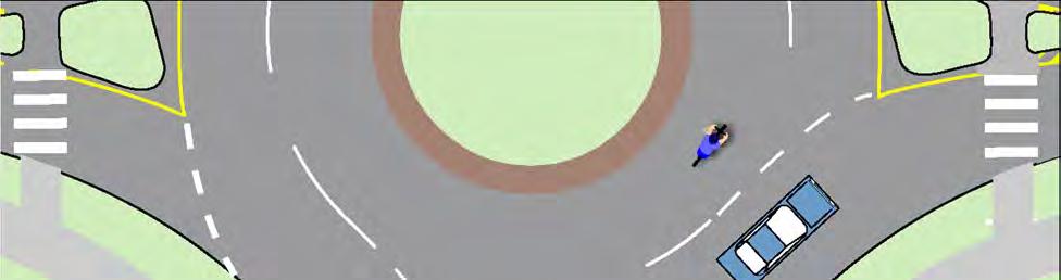
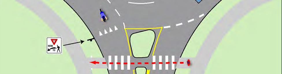
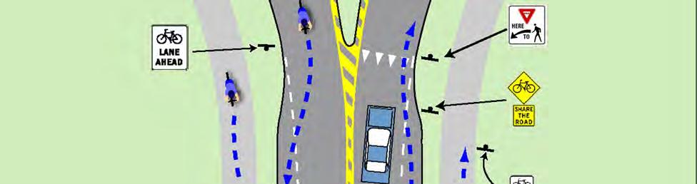
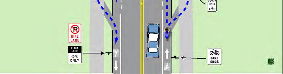
145 Fig. 5.4Z. Non-motorized Design Considerations for Roundabouts 141


146 Fig. 5.4AA. Ladder Style Crosswalk Design Guidelines Description A combination of Transverse and Longitudinal style crosswalks to improve visibility for motorists and usability for pedestrians with sight impairments. Key Elements: 1. All crosswalk markings are highly skidresistant and strongly contrast pavement. 2. Longitudinal lines are no more than 1 wide to minimize areas of thermoplastic markings. 3. The clear spacing between the longitudinal lines is no more than 2 to improve the visibility of the crosswalk to motorists. 4. Transverse lines are used to aid pedestrians with sight impairments in finding the edge of the crosswalks (this can be difficult with longitudinal lines alone, especially when spaced far apart). 5. The width of the crosswalk is set such that it can easily accommodate all pedestrians crossing the road. Application For all marked mid-block crosswalks across Arterial and Collector streets and signalized crosswalks downtown. Also, on local streets where there is a high potential for conflict between motorists and pedestrians such as crosswalks that serve schools. Locations where pedestrian crossing is sporadic require high visibility as the motorist s expectation for the presence of pedestrians is low. Example 142
147 5.5 Neighborhood Connectors The local roadways that serve residential and mixed use areas are critical to the success of the City s nonmotorized system. Local roads that serve neighborhoods are typically attractive non-motorized links due to the lower vehicle volumes and speeds. Bicycle Travel in Neighborhoods Bicycles typically do not need any special accommodations on local residential streets as they can comfortably share the road with the limited motor vehicle traffic. Some local residential streets, by themselves or in combination with off-road paths, provide excellent and attractive alternatives to the primary road system. In some cases, it may be desirable to sign bicycle routes that provide access to destinations such as schools and parks where the route may not be obvious to a cyclist unfamiliar with the area. See Section 5.6 Bike Route Signs and Wayfinding for more information. Public vs. Private Roads It is just as important to provide safe and comfortable pedestrian facilities on private streets as on public streets. Regardless of ownership, neighborhood roads should include concrete sidewalks a minimum of 5 wide and compliant with ADA standards, on both sides of the street with a landscaped buffer between the sidewalk and the road. An issue with private roads is the perception that they may not be open for use by the general public. For this reason public roads should always be the preference for new developments. In crafting development agreements that incorporate private roads it should be clear that the roads are open to all pedestrians and bicyclists and that there should be no signage of physical structures that imply that non-motorized access is limited to the residents of that neighborhood. Both public and private neighborhood streets should be designed to incorporate many of the same pedestrian safety enhancing measures as those previously noted for primary public roadways. These include reduced curb radii, narrower street widths, curb extensions, and traffic calming measures such as speed tables. Connectivity Between Neighborhoods and to the Primary Road System If a new development has limited road access to surrounding arterial streets, special access points for pedestrians and bikes should be incorporated between property lines or along utility rights-of-way. Nonmotorized connectivity between adjacent residential, commercial and institutional developments should be provided. The City can regulate the form and shape of new neighborhoods to support and promote pedestrian and bike mobility by modifying master plans and development standards. Careful site design encourages walking by making non-motorized travel more direct than motorized transportation modes. 143

148 Neighborhood Roadways Design Public and private street standards should clearly require sidewalks on both sides of the street, subject to City review. Neighborhood streets should have the following amendments to encourage pedestrian access in neighborhoods: Slow vehicular speeds. Small block sizes. Interconnected streets. Sidewalks on both sides of the streets. Landscaped buffer between the street and the sidewalk with street trees that will provide shade. Connections to adjoining neighborhoods. Direct walkway connections between residential areas and commercial and institutional areas when not afforded by the street system Fig. 5.5A. Cul-de-sac connector Grid patterned streets with sidewalks and small block sizes are preferred for pedestrian use. They allow pedestrians to have multiple options in route choices and follow the most direct route possible. It is desirable for street networks and pedestrian facilities to correspond wherever possible. However, even if grid streets are not desired or feasible, pedestrian and bike links should still be provided even where the road does not connect. If cul-de-sacs and dead end streets are used, pedestrian and bike cut-throughs meeting AASHTO guidelines should be created to link to adjacent streets (Figure 5.5A). 144


149 5.6 Bike Route Signs and Wayfinding Route Characteristics Routes signed as a Bike Route should be roads that have a relatively high Quality/Level of Service for bicyclists. The route should not have any known hazards to bicyclists and should be maintained in a manner that is appropriate for bicycle use. While many local roads may meet these criteria, the key is that the road is part of a specific route to a particular place. Obvious routes need not be marked. Bike Routes should be used judiciously to identify obscure routes to key destinations that avoid travel along major roadways. Where a bicycle route on a local road intersects a busy multi-lane primary road and continues on the other side of the road, a traffic signal or appropriately designed mid-block crossing should be provided. Bike Routes generally do not include specific bicycle improvements such as Bike Lanes. Bike Lane pavement markings and signs already indicate that a road segment is designed to specifically accommodate bicycles. Bike Route signs are to be used where no obvious bicycle facility exists yet the route is advantageous to bicyclists. Thus road segments with Bike Lanes should generally not be marked as a Bike Route. D1-1c MUTCD 2009 Bike Route Guide Signs The most basic bike route signs are Bike Route Guide Signs (shown to the left). These are used on designated bike routes to inform bicyclist of changes in direction and the distance to the next destination. Bike Route Guide Signs are placed at changes in direction of designated bike routes. Not every bicycle facility will necessarily be designated a bike route. Bike routes should be used where the signage would help direct a bicyclist to a key destination that may not be obvious. Bike Route Identification Signs Some bike routes are significant enough to warrant a name or numerical designation. Typically these are key connectors between off-road trails or used to help delineate a trail that incorporates many different facility types. Bike Route Identification Signs (shown to the right) establish a unique identification for a bike route. These signs are typically used with auxiliary plaques that indicate the direction of travel and any changes in direction of the route. M1-8a MUTCD


150 5.7 Bike Boulevards and Neighborhood Greenways Bicycle Boulevards and Neighborhood Greenways function as premium bike routes. They create an attractive, convenient and comfortable environment that is welcoming to all cyclists and pedestrians. Bicycle Boulevards and Neighborhood Greenways and are a great way to navigate through a city, where arterial and collector roads may be undesirable. They can also function as an extension of an off-road trail, creating a smooth transition between two trail systems. They incorporate the bicycle route elements discussed in the previous section. Bike Boulevard Design Elements Bicycle Boulevards are located on low-volume and low-speed streets that have been optimized for bicycle travel through special treatments that allow through movement for cyclist while discouraging similar through trips by non-local motorized traffic. Bicycle Boulevards can take many forms. Special treatments such as traffic calming and traffic reduction, signage and pavement markings and intersection crossing treatments all help to optimize these routes for cyclists. The following are some example of treatments that can be used to develop a Bicycle Boulevard: Pavement Markings Identifies this route as a Bicycle Boulevard Traffic Reduction Restricts motorized vehicles while allowing bicycle traffic Traffic Calming Mini Traffic Circles help reduce speed at intersection without stopping Traffic Calming Speed Tables help to reduce speed and enhance the crosswalk 146


151 Fig. 5.7A. Each corridor needs to be specifically tailored to its needs by selecting the appropriate mix of design elements. Some local streets may already have traffic conditions optimal for a bicycle boulevard and may require minimal improvements to become a new bicycle boulevard. The following are examples of these types of treatments that are already in East Lansing: Restricting Motorized Vehicular Traffic at Grove St and Linden St Traffic Calming Button at Portage Path and Whitehills Drive Raised Median at Stonegate Entrance 147


152 Neighborhood Greenway Design Elements Neighborhood Greenways incorporate all the elements of bicycle boulevards but take the concept to the next level. They typically incorporate sustainable design elements such as rain gardens, bio-swales, native plantings, etc. They should incorporate pedestrian amenities such as art installations; benches; interpretive sign; and community vegetable and ornamental gardens. They may take on many different looks from avant-garde to traditional. 148


153 5.8 Shared-Use Pathways There are many types of Shared-Use Pathways, each with unique issues. One type of Shared-Use pathway is the independent pathway that is separate from the road system. Independent pathways include rail-to-trail corridors, paths through parks and other trail systems. Independent pathways can be important and beneficial links to the non-motorized transportation system provided they have direct connections to the existing network of bike lanes and sidewalks. If designed and maintained properly, they can be the jewels of a City s non-motorized transportation system. Independent pathways should be designed to accommodate shared uses including cyclists, walkers, strollers, in-line skaters, and people in wheelchairs. For the safety of all users, the pathway should be built wide enough to accommodate these shared uses. AASHTO guidelines indicate that 10 wide path is the minimum width for a Shared-Use path. The preferred minimum width is 12 in most cases in urban areas with 14 to 16 being common widths. Studies done by the Rails-to-Trails Conservancy have shown that off-road pathways in general are quite safe from a personal safety standpoint. But in urban areas it is important that pathways follow the principles of Crime Prevention Through Environmental Design (CPTED). Trail Cross Section Design Guidelines Figure 5.8A below illustrates several key points about the design and maintenance of Shared-Use paths. Whether the surface of the path is asphalt, fines or other material, it should have a solid base and positive drainage as the path may have maintenance vehicles on it at all times of the year. The vegetation along the trail should be regularly trimmed and mowed to maintain a clear zone around the trail. Fig. 5.8A. Typical Path Cross Section 149


154 Independent Pathway / Road Intersection Design Guidelines Independent pathways often intersect roadways at unsignalized mid-block crossings. Many of the design guidelines for a typical mid-block crosswalk apply but because of the unique nature of independent pathways, several additional safety points must be considered. The following plan illustrates the key points needed for a safe design of the intersection of an independent pathway with a roadway: Clear signage that identifies user rights-of-way and notifies both the users of the pathway and the motorists that an intersection is approaching. Pavement markings at the beginning of the trail intersection notify users of direction of travel and rights-of-way. Pavement markings further along the trail should be minimized to avoid visual clutter. The pathway should meet the roadway at as close to a 90-degree angle as possible for maximum visibility of users. Supplemental trail signage is often set back outside the road right-of-way. Regardless of the surfacing material of the trail, asphalt or concrete should be used for the portion of the trail that intersects the road. The hard surface increases traction for bicycle users and cuts down on debris from the shoulder of the road accumulating in the pathway. The change in materials can also help to notify users of the upcoming intersection. At rural intersections, gravel shoulders should also be paved adjacent to the trail to minimize debris in the stopping zone. Fig. 5.8B. Typical Pathway/Roadway Intersection R1-1 W3-1 W


155 Fig. 5.8C. Trail Signs at Road Intersections Trail View Key Recommendations: Two sign posts form a gateway to the trail at road intersections. On the right above a Stop or Yield sign, a standard street name sign is used to identify the cross street. All parts of the signs should be set back 3 from the trail. On the left side, an optional plaque identifies the local agency in charge of the trail, trail rules, and emergency and maintenance contact numbers. Road View Key Recommendations: On the right side, a No- Motor-Vehicle Sign and a Bicycle Yield-to-Pedestrian Sign should be posted to address the key rules of the trail. On the left side, a Bike Route Destination sign listing the direction and distance to the next major destination may be placed. On the left side, the Bike Route Identification Sign with a custom logo, direction of travel and route name may be used to identify the route. A detectable warning strip should be placed across the entire trail. Pavement markings should be used for the first 100 to 150 of trail. 151

156 5.9 Commercial Centers Many new commercial, office, institutional and mixed use developments being built today are designed for easy access by motor vehicles and do not take into adequate consideration the patrons arriving by other means of travel. Aspects of site design can discourage non-motorized traffic when designed solely for automobile use. New developments today often have poorly placed bike-parking facilities, large setbacks with parking lots that lack direct access for pedestrians or bicyclists and face large arterial roadways with little or no direct access to neighborhoods and residential areas that may be surrounding them. These problems can be remedied by improving site design and enhancing connections to the external transportation system. Most commercial developments are oriented to motor vehicles, resulting in an often oppressive environment for pedestrians and bicyclists. Circulation within the Site Buildings with frontages along the street create a streetscape that is comfortable and accommodating to pedestrians, and help keep traffic moving at slower speeds. Parking to the side or the rear of the building keeps the streetscape intact, allows easy access for pedestrians from adjacent sidewalks and minimizes automobile and pedestrian conflicts. As the building frontages are moved back from the streetscape to accommodate parking, the pedestrian s sense of exposure to traffic, the distance they must walk to access the store, and their resulting discomfort substantially increases. Setback of the building frontages from adjacent intersections also complicates pedestrian travel across the roadways. Typical development patterns are L shaped with the majority of buildings set back from the intersection and one or two isolated buildings near the intersection. This pattern places the majority of the buildings away from the primary pedestrian crossing point and puts a large expanse of parking between the isolated buildings on the corner and the majority of the buildings. Depending on the development across the street, L shaped developments can set up strong pedestrian desired lines across mid-block locations. Because of the large scale of most of these developments, the distance between the desired lines and the signal is significant. If orienting proposed development projects to improve non-motorized uses is not a feasible option in designing the layout of the buildings, then providing clear, direct and safe pedestrian access at mid-block locations is necessary to minimize out of direction travel through or around the parking lot by pedestrians. Parking lots can be dangerous areas for pedestrians and present many challenges for safe navigation. Older adult pedestrians have a high incidence of accidents involving vehicles backing up, a common maneuver in parking lots. 20 Site plans should be required to include the following design measures: Reduce building setbacks as much as possible and provide walkways to the entrances that are clearly marked, accessible and buffered from the surrounding parking lot. Use raised crosswalks and striping to clearly deferentiate the walkways from driveways. Speed tables and raised crosswalks can calm traffic and increase visibility. 20 National Highway Traffic Safety Administration. Pedestrian Safety for the Older Adult. 152


157 Fig. 5.9A. Typical Commercial Center at Intersection of Main Roads Fig. 5.9B. Pedestrian Friendly Commercial Center Alternative 153
158 Provide trees and other plantings to buffer pedestrians from parking areas, enhance parking lot aesthetics, and minimize the pedestrian s exposure to the elements while crossing the vast expanse of pavement. Walkways should have direct and clear access to building entrances and be designed to safely go through the parking lot, or circumnavigate it if necessary. Walkways along the buildings should be wide enough to accommodate several people abreast and have frequent curb cuts and ramps for accessibility, as well as tactile and audible pedestrian information. Just as pedestrians need direct and clear access through the parking lots to the buildings, bikes should also be safely directed through the parking lot. Bike parking should be provided in a visible and convenient location. Many cyclists are reluctant to lock their bikes in an area that is out of the way and unfrequented because of the greater likelihood of theft. This leads to situations where bikes are locked to anything available such as signposts or railings. These bikes can cause hazards for pedestrians and obstacles to accessibility. Providing bike parking facilities in convenient and well-lit locations will minimize these problems. The site plan review process will allow the City to ensure that these design measures are followed. The City should require that developers include these specific pedestrian and bike accommodations early in the site planning. Connections to the External System The site must have convenient and safe access to pedestrian, bicycle and transit facilities outside the development. Frequently, large new developments are located on the edge of town along major arterials with limited non-motorized facilities. New developments should always connect to an existing nonmotorized transportation network. Commercial developments should include specific plans for connecting to existing facilities and neighborhoods in surrounding areas. Motor vehicle access to commercial development should be constructed as a conventional driveway with small turning radii and a ramp up to the sidewalk level, rather than a typical public intersection where the roadbed continues at the same level and there are curbs on either side. Use of driveway entrances rather than typical intersections enhance pedestrian safety and comfort because motorists must drive slowly when entering and exiting the development. When a typical intersection-style entrance is used, the sidewalk should continue across the entrance, preferably at sidewalk height, so the right-of-way is clearly established and motorists understand they are entering a pedestrian area. Supplemental signage and crosswalk pavement markings should be used to indicate a crosswalk and the pedestrian right-of-way. Plantings should be pulled back away from the entrance crossings to allow maximum visibility for both pedestrians crossing the entrance and the cars entering the commercial development. The radius of the intersection curb should be kept as small as possible, and the width of the driveway should be the minimum needed. Just as roads are updated to accommodate vehicular access at new developments with turning lanes or signals, so should non-motorized facilities be updated with new crosswalks, signage and pedestrian signals. New roadway designs often favor access control for businesses along the road. In this scenario, several businesses share access through one driveway instead of each business having its own entrance and exit onto the main street. In addition to the advantages for vehicles, this is an advantage for the lateral movement of pedestrians along the street because they do not have to cross as many driveways. 154
159 However, more direct pedestrian access points from the sidewalk to the individual building entrances should be incorporated. The spacing of crosswalks along the primary road to developments across the road should also be considered. The design and placement of the buildings should allow direct and clear access from surrounding neighborhoods and residential areas. Too often, what could be a short walk to a nearby store from a residential street becomes dangerous and un-navigable because the store does not have public access on the side facing the residential streets. Both pedestrian and bicycle access should be unimpeded from these areas. During site plan evaluation, development access and travel distances from surrounding residential areas should be a prime consideration. Encouraging Mixed Use While tying commercial developments to surrounding residential areas is a good practice, a better practice is to eliminate the segregation of commercial and housing areas. Incorporating higher density housing into commercial developments can dramatically alter the character of commercial development making the project more similar in feel to a small downtown rather than a strip development. For more information see the Land Use Considerations in the next section. Mixed land uses can significantly increase the number of non-motorized trips. 155
160 Site Design Checklist A site design checklist or similar tool should be provided to developers and used by the City in their review of site plans to make sure that bicycle and pedestrian issues are being adequately addressed. The following checklist was adapted with minor modifications from The Canadian Guide to Promoting Sustainable Transportation through Site Design by the Canadian Institute of Traffic Engineers. It is a part of a larger publication that looks at site design issues more fully. Land Use & Urban Form Checklist: Densities are sufficient to support transit (3 to 7 households an acre / 4 to 7 jobs an acre) Highest density land uses are located close to activity nodes such as transit corridors and intersections. Proposed use provides or adds to a diversity of land uses in the surrounding area and does not result in large tracts of similar uses. Proposed use is compatible with adjacent land uses and with long term land use plans for the area. Adjacent street network provides for connectivity of transit, cycling and pedestrian routes. Mixed uses help support non-motorized transportation. Safety & Security Checklist: Overall site design attempts to minimize conflict points between vehicles, pedestrians and cyclists. Sight distances have been considered in overall site design and in the placement of entry signs and landscaping. Consideration has been given to personal security for pedestrians, cyclists and transit users. Buildings are located close to the street, but provide adequate clearance for pedestrian activities along street frontage. Where appropriate, retail, restaurants and other pedestrian oriented uses animate the street frontage. Building Entrances Checklist: Building entrances are located close to the street, with direct pedestrian access. Potential conflict points between users arriving by different modes are minimized. Internal Transportation Network Checklist: Roads and paths match up with surrounding networks and ensure direct connections through the site for cyclists and pedestrians. Block lengths are limited and mid-block crosswalks are provided where appropriate. Traffic-calming principles are applied, where appropriate (proper site design should avoid the need to apply extensive traffic calming). Appropriate measures have been taken to ensure easy progress of transit through the site. 156
161 Desired Pedestrian & Cyclist Routes Checklist: Safe, continuous and clearly defined routes for pedestrians and cyclists are provided along desire lines including links to surrounding residential areas. Weather protection and amenities such as trees are provided. Intersections are designated to facilitate pedestrian and cyclist crossings. Transit Stops Checklist: Walking distances to stops do not exceed 1300 feet, and pathways to stops are safe and direct. Waiting areas are well lit and attractive. Site Grading Checklist: Terrain along pathways is kept reasonably level, and ramps are also provided wherever stairs are necessary. Slopes along pathways are designed to avoid the ponding of slush and water. Motor Vehicle Parking Configuration & Treatment Checklist: Off-street parking is located away from the street, preferably behind buildings or underground. Vehicle access is separate from pedestrian access, and access and egress controls are designed so vehicles do not block pedestrian ways. Parking lots are kept small and designed to prevent speeding. Pedestrians have protected walkways through the lots. Motor Vehicle Parking Supply & Management Checklist: Off-street parking should be provided, where necessary, at the sides and rear of buildings. Bicycle Parking Checklist: Bicycle parking is located near entrance for short term users in a high visibility location. Weather protected bicycle parking for longer term users is provided in a secure area. Storage possibilities for gear are considered. Showers, changing rooms and lockers are provided within employment centers. Passenger Pick-up & Drop-off Areas Checklist: Passenger pick-up and drop-off areas are located to the side or rear of buildings, downstream from the entrance, but no more than 100 feet away from it. Loading Areas Checklist: Loading areas are located off the street, and are screened from public view. Loading area access is designed so that pedestrian, cyclist, and transit routes are never severed. 157
162 Internal Road Design Checklist: Appropriate traffic signals and compact geometry of intersections control speeds and allow for safe passage of cyclists. Roads are designed to cross at right angles. Sight lines are respected. Lanes are designed to accommodate motor vehicles and cyclists, and remind users of the other networks on the site. Facilities for cyclists and sustainable modes are provided and continued across the site. Pedestrian Facilities Checklist: Sidewalks are provided along all roads, and follow pedestrian desire lines where possible. Properly signed crossings are provided wherever a path or sidewalk crosses a road. Pathways are clearly defined, delineated, and are of a sufficient unobstructed width. Appropriate amenities such as lighting and weather protection are provided and safety along path is addressed. Transit Facilities Checklist: Stops are located close to the main entrances of activity generators. Crosswalks are provided at all stops. Stops and waiting areas are properly illuminated, visible from a distance, and have warranted amenities such as shelters and benches. Spacing between stops is minimized. Shelters and rest areas are provided at transit stops and locations where there is a high number of users, the elderly or the disabled. Shelters and rest areas are identifiable, accessible, placed appropriately, and are comfortable. Wayfinding Checklist: Appropriate signage and physical features are provided for users of all networks to determine their location, identify their destination, and progress towards it. Street Furniture & Amenities Checklist: Amenities are provided to create a comfortable and appealing environment, pre-empting litter and responding to user needs. Landscaping Checklist: Landscaping does not compromise user security and safety. 158


163 5.10 Land Use Planning Land use patterns greatly affect the viability of non-motorized transportation. There is a general consensus based on a significant body of research that three key issues determine how supportive an environment is to walking, bicycling and transit. Density The density of the residential population determines if an area is capable of supporting a transit system, both economically and efficiently. The Southeast Michigan Council of Governments generally considers that at least 3 to 7 households an acre and 4 to 7 jobs an acre are necessary to support a transit system. Higher density encourages retail services needed to maintain a healthy urban environment. Increased population density introduces a critical mass of pedestrians who provide comfort and security to each other with their combined presence. Higher density uses support a non-motorized transportation system more than low density land uses. It has been noted that the key indicator of the vitality of a place is the presence of pedestrians. Diversity The diversity of land uses refers to the proximity of trip origins and destinations. If the distances are comfortable for bicyclists and/or pedestrians they will be more likely to use non-motorized means, thus reducing the number of motor vehicle trips. A diversity of services at key public transportation stops allows transit users to minimize their travel and combine many errands at one place. Design The design of the non-motorized system and the support facilities determine if a pedestrian or bicyclist trip will be safe, comfortable and convenient. The design is also key in determining how accessible transit stops are and how large an area each transit stop draws from. Design is important on both a macro and micro scale. On a macro scale the directness and interconnectedness of the network is critical for permitting quick access to adjacent diverse land uses. On a micro scale an environment that rewards non-motorized users with safe and pleasant surroundings encourages use. 159


164 Density, diversity and design must all work in concert to make an environment that supports alternative transportation. The absence of one element has the ability to reduce the positive impact of the presence of the other two. Municipal planning can guide land use plans and zoning plans to encourage dense, mixeduse development and design considerations that support a variety of transportation choices. Ordinances may be used to permit mixed-use developments with higher densities, as well as promote increased densities around major destination points and transit lines. A community s transit, bicycle and pedestrian friendliness has as much to do with a community s population density, land-use diversity and the layout of the street network as it does with providing specific facilities for bicyclists and pedestrians. 160


165 5.11 Downtown Streetscape The design of the downtown pedestrian environment has a direct effect on the degree to which people enjoy the walking experience. If designed appropriately, the walking environment serves not only the people who currently walk but also entices those who don t. When considering the appropriate design of a certain location, designers should consider not only existing pedestrian use, but how the design will influence and increase walking in the future. Additionally, designers must consider the various levels of walking abilities and local, state, and federal accessibility requirements. Although these types of requirements were specifically developed for people with walking challenges, their use will result in pedestrian facilities that benefit all people. In the downtown area, pedestrian accommodation takes on a special importance. Though the following guidelines are intended for the downtown area, many have applicability in other areas of town. Zones in the Sidewalk Corridor The Sidewalk Corridor is typically located within the public right-of-way between the curb or roadway edge and the property line. The Sidewalk Corridor contains four distinct zones: Curb Zone Furnishings Zone Through Pedestrian Zone Frontage Zone Curb Zone Furnishings Zone Through Pedestrian Zone Frontage Zone 161


166 The Curb Zone The Curb Zone defines the pedestrian area, providing a buffer between the sidewalk and street. This zone usually consists of the width of the curb and may contain space for unloading passengers or freight. Curb Zone width should be 18 inches where pedestrian or freight loading is expected and may conflict with obstacles, such as planters, in the Furnishings Zone. Curb Zone width along all other streets should be a minimum of six inches. Curbs prevent water in the street gutters from entering the pedestrian space, discourage vehicles from driving over the pedestrian area, and make it easy to sweep the streets. In addition, the curb helps to define the pedestrian environment within the streetscape, although other designs can be effective for this purpose. At the corner, the curb is an important tactile element for pedestrians who are finding their way with the use of a cane. On-Street Parking The presence of on-street parking has a favorable impact on the quality of pedestrian environment. Onstreet parking increases the lateral separation between pedestrians and moving traffic as well as presenting a substantial buffer between the sidewalk and the street. On-Street Parking also has a traffic calming effect with motorists generally being more cautious looking for opening doors and cars pulling in and out. Where the buffer zone is limited, on-street parking can compensate for lowered comfort level. Thus, if on-street parking is only allowed on one side of the street due to road width constraints, the parking should be located on the side with the least buffer, all other factors being equal. 162


167 The Furnishings Zone The Furnishings Zone lies between the Through Pedestrian Zone and Curb Zone. All fixtures and street furniture should be contained in the Furnishings Zone to keep the Through Pedestrian Zone free for walking. This is also the area where people alight from parked cars along the roadway. Separating pedestrians from travel lanes greatly increases their comfort as they use the Sidewalk Corridor. The buffer function of the Furnishings Zone is especially important on streets where traffic is heavy, yet along many of these streets the existing Sidewalk Corridor is narrow. Where possible, additional width should be given to this zone on streets with traffic speeds over 35 mph. The furnishing zone is also the area where elements such as signal poles, utility poles, controller boxes, hydrants, signs, parking meters, driveway aprons, grates, and hatch covers are located. Wherever it is wide enough, the Furnishings Zone should include street trees and be paved with tree wells and planting pockets for trees, flowers, and shrubs. Furnishings Zone Elements Trees, planters & landscaping Trash & recycling receptacles Bicycle racks Street lights Benches Consolidated news racks (advertising racks should be discouraged) Clocks Public art Banners & flags Information kiosks Fountains Wayfinding/signage Street Vendors 163
168 Planting Street trees are a highly desirable part of the pedestrian environment, especially large-canopied shade trees. Every effort should be made to provide enough room in the Sidewalk Corridor to accommodate trees in addition to pedestrian travel. Tree limbs and branches should be trimmed to leave 7 6 clear above the level of the sidewalk. Street Furnishings Street furnishings can enliven and provide variety to outdoor public spaces. They serve an aesthetic as well as utilitarian function. Proper design and placement of street furnishings will reinforce the downtown design theme throughout East Lansing. The amount and types of furnishings provided will vary depending on the uses along the street and amount of pedestrian activity. On sidewalks of ten feet or greater, the Furnishings Zone width should be a minimum of four feet. A wider zone should be provided in areas with large planters and/or seating areas. Street furnishing should create a unified look. The color and appearance of street furnishings should be selected in concert with other design elements (such as special paving), surrounding furnishings, and the area as a whole. Street furnishings should be securely anchored to the sidewalk and protected with a graffitiresistant coating to ensure a long-term quality appearance. The design and selection of street furniture should include consideration for the security, safety, comfort, and convenience of the user. Street furniture should be grouped together to conserve sidewalk space, provide complementary functions, and maintain a clear width sufficient to accommodate pedestrian flow. A greater number and type of furnishings should be located in high-use pedestrian traffic areas. The design and siting of furnishings should accommodate the physically challenged. This includes providing space adjacent to walkways for wheelchairs and/or strollers. Textured paving may be used in the Furnishings Zone for decorative purposes. To reduce street clutter, consolidate signage on light poles, and other permanent fixtures, wherever possible. Dual-level lighting fixtures, which illuminate the street and sidewalk areas, are recommended on downtown commercial streets. Street Vendors Street vendors contribute to the life of downtown and provide inexpensive food to many downtown employees and visitors. When permits are granted to vendors the location should be carefully defined so carts and canopies do not interfere with the through pedestrian zone. The use of generators should be strictly regulated or banned as the sound of generators severely degrades the pedestrian experience downtown. 164


169 The Through Pedestrian Zone The Through Pedestrian Zone serves as the sidewalk area dedicated to walking and is located between the Frontage Zone and Furnishings Zone. This zone should be entirely free of permanent and temporary objects. Width As a general rule, the zone should be at least 6 feet wide in downtown, with 8-10 feet recommended. A minimum of five feet should be reserved to allow for two people to walk comfortably side by side and meet ADA requirements. The volumes of pedestrian traffic should be evaluated prior to granting sidewalk occupancy permits to make sure there is adequate sidewalk width to accommodate typical pedestrian volumes. An acceptable width would result in a pedestrian having to make only minor adjustments in speed and direction to avoid conflicts with other pedestrians and obstacles. Alignment The through pedestrian zone should keep in a straight line for an entire block. Zigzagging alignments to accommodate café tables alternately located against buildings and in the furnishings zone reduces the capacity of the sidewalk and makes it difficult to transverse for persons with sight and mobility impairments. Intruding Elements Driveway aprons should not intrude into the Through Pedestrian Zone. This Zone should be kept clear of any fixtures and/or obstructions. Clearance should be provided in a generally straight path for the convenience of all pedestrians, but especially for the sight-impaired. The Sidewalk surface must be stable, firm, smooth, and slip-resistant, per the ADA. Constraints in the Sidewalk Corridor Most of East Lansing s downtown grid has already been built, and in many cases the existing Sidewalk Corridor is too narrow to accommodate the recommended zone widths. Competing needs for space in a constrained Sidewalk Corridor can be resolved in either of two ways: by compromising on the minimum required clearance for some or all of the zone or by increasing the dimensions of the Sidewalk Corridor. The resolution of such conflicts in any given case must be based on considerations of balancing the conflicting uses and adjusting the magnitude of the solution to fit the magnitude of the project. Widening the Sidewalk Corridor In some cases, it is possible to increase the dimensions of the Sidewalk Corridor, either through acquisition of right-of-way or public walkway easements, or by reallocation of the overall right-of-way (such as by narrowing travel lanes or reducing the number of lanes). As part of a roadway reconstruction project on a street with a narrow Sidewalk Corridor, the project planners should first analyze the impact of reclaiming a portion of the existing right-of-way. If this proves impractical, the feasibility of acquiring 165
170 additional right-of-way should be examined. Acquisition should be considered where its cost is reasonable in proportion to the overall project cost. In the case of infill development, the dedication of public right-of-way or the granting of a public walkway easement to widen the Sidewalk Corridor may be included as a requirement for obtaining a building permit or land use approval. Grates All grates within the sidewalk shall be flush with the level of the surrounding sidewalk surface, and shall be located outside the Through Pedestrian Zone. Ventilation grates and tree well grates shall have openings no greater than 13 mm (1/2 in) in width. Hatch Covers Hatch covers should be located within the Furnishings Zone. Hatch covers must have a surface texture that is rough, with a slightly raised pattern. The surface should be slip-resistant even when wet. The cover should be flush with the surrounding sidewalk surface. Surfaces Walking surfaces shall be firm and stable, resistant to slipping, and allow for ease of passage by people using canes, wheelchairs, or other devices to assist mobility. Sidewalks are generally constructed of Portland cement concrete. Brick or concrete unit pavers may also be used particularly in the Furnishings Zone or around mature trees where sidewalk lifting is a problem. 166


171 Frontage Zone The Frontage Zone is the area between the Through Pedestrian Zone and the property line. This zone allows pedestrians a comfortable shy distance from the building fronts, in areas where buildings are at the lot line, or from elements such as fences and hedges on private property. Where no Furnishings Zone exists, elements that would normally be sited in that zone, such as transit shelters and benches, telephone kiosks, signal and street lighting poles and controller boxes, traffic and parking signs, and utility poles, may occupy the Frontage Zone. In some cases, easements or additional right-of-way may be required to allow for these items. For residential and mixed-use buildings built to the right-of-way line, these elements should not be sited in the Frontage Zone, as they could block access to an existing or future building. Private temporary uses such as sidewalk cafes may occupy the Frontage Zone, so long as the Through Pedestrian Zone is maintained. Encroachments Fences and walls, when permitted, must be at least 1 foot behind the back of the sidewalk (or the future sidewalk, if none exists). Encroachments into the right-of-way should not be permitted where the existing sidewalk corridor is less than the recommended width. Care should be exercised if elements such as standpipe systems for fire safety project into the Frontage Zone from a building face. Standpipes systems should only project a maximum of 1 foot but not more than four inches if they project in the area between 2 feet- 3 in and 6 feet 8 inches above the sidewalk, per the ADA. Adjacent Parking Lots Where there is no landscaping between parked vehicles and the right-of-way, wheel stops or other means such as walls or fences should be used to prevent parked vehicles from overhanging into the Frontage Zone. 167
172 168

173 6. Education and Marketing The education and marketing of the City s non-motorized Transportation Plan is key in promoting nonmotorized transportation while providing important resources and information. This section outlines recommendations and strategies on how the City can develop a program for public outreach and education for the non-motorized system. Topics: 6.1 Existing Promotional and Marketing Activities 6.2 Opportunities and Barriers 6.3 Public Outreach and Educational Strategies that Promote the use of Sustainable Transportation 6.4 Recommendations 6.5 Resources Imagine walking into a new sandwich shop. In front of you is a menu 6 feet high and 8 feet wide filled with an overwhelming array of sandwich choices. Many of the sandwiches listed have ingredients you've never tried before. So you decide to go with what you know: a ham and cheese sandwich on white bread. The next day you walk into the shop and order the same thing. And again the day after that. Even though some of the other sandwiches might be cheaper, or better for you, you are hesitant to break out of your routine. Many people experience their transportation choices in the same way. They think "I could walk to the grocery store or bike downtown, but will it be safe? Will I get dirty? Will I look silly?" So many people stick to what they know and lose out on the great benefits non-motorized transportation can offer. So how do we break people out of their routine and encourage them to try non-motorized transportation? A public education and outreach program can provide the encouragement many people need to move them from considering using non-motorized transportation to actually using it. The following recommendations outline the strategies the City can use to develop a public outreach and education program for the non-motorized system. It is important that the recommendations outlined in this section are done in tandem with the infrastructure changes so that what is being sold by the outreach program is truly a good product. If people are told that a particular bike route is safe and then have a fearful experience when they try it out, the result will be counterproductive. 169
174 6.1 Existing Promotional and Marketing Activities The following is a list of activities that are already being done to promote non-motorized transportation in the East Lansing area. CATA Programs (Capital Area Transportation Authority, cata.org) Clean Commute Options CATA is the largest transportation provider in the region. As part of its efforts to promote a variety of transportation choices to commuters, CATA runs a Clean Commute Options Program. The Clean Commute Options Program (started in 2006) encourages commuters in Lansing and East Lansing to look at all of their commuting options, including biking and walking. The Clean Commute Options Program works with municipalities, businesses, employees and schools. In September of 2008, the Clean Commute Options Program had 500 participants. As of August 2009, the Program now has 1,050 participants. Through the Clean Commute Options Program, CATA works with businesses, conducts transportation fairs, helps employees on site and much more. Recently, MSU agreed to use CATA and Clean Commute Options as the official source of commuting information for employees and students. The Clean Commute Options Program partners with many organizations, including MichiVan and bicycling groups. CATA's Clean Commute Options portion of their website contains information on biking and walking to work. As part of Clean Commute Options, CATA produces a monthly newsletter (The Clean Commute Chronicle) with information on sustainable transportation options. Bike Racks and Lockers All CATA buses are equipped with bike racks and CATA also manages some bike lockers in downtown East Lansing and bike parking at their MSU location. Clean Commute and Campus Challenge Week CATA also organizes a Clean Commute Challenge and Campus Challenge Week in September. Both of these week-long events promote all commuting options, including walking and biking. Each event also allows individuals to log sustainable commutes on the CATA website to win prizes. The Campus Challenge is a Michigan-wide challenge with different colleges competing against one another to try to have the most sustainable commutes. For more information on these challenges, visit Challenge-is-September-22-26th/Default.aspx Mid-Michigan Environmental Action Council (Mid-MEAC, Smart Commute Mid-MEAC organizes Smart Commute activities throughout the year (especially in May and September) that promote biking and walking as commute options. The highlight of Smart Commute is the Smart Commute Challenge, which encourages companies in Lansing and East Lansing to compete against one another to see who can log the most sustainable commutes for two weeks in June. The Challenge has an individual as well as company component to it. In addition, the Smart Commute program teaches bike commuting classes in May as well as other walking and biking events. More information can be found here: Smart Commute is coordinated by a local consultant Jessica Yorko, who works with different community organizations, including Mid-MEAC, CATA, the Tri-County Bicycle Association, and MSU Bikes put on Smart Commute. According to Michigan Environmental Council employee and community resident Rory Neuner, Smart Commute has been a successful program in terms of getting companies to participate, but lacks the funds and corporate partners to move it to the next level. 170
175 Walk and Bike Lansing ( Walk and Bike Lansing is a taskforce of Mid-MEAC that is currently advocating for the City of Lansing to pass the Complete Streets ordinance. Rory Neuner of the Michigan Environmental Council sits on this Taskforce. She says the taskforce is interested in going regional with its efforts and perhaps become a standalone organization, separate from Mid-MEAC. Information and Resources Mid-MEAC's website also provides a variety of resources for bike commuters including information on commuting classes, bike routes, bike parking and more. Tri-County Bicycle Association ( The Tri-County Bicycle Association mostly runs bike rides in the greater Lansing Area, but does have a safety and education component to their Board. Safe Routes to School ( City of East Lansing has an active Safe Routes to School Committee with three schools having Safe Route Action plans to make it safe for kids to walk and bike to schools. MSU Bikes ( Michigan State University has a comprehensive program to promote biking to MSU students, faculty and staff. Included in MSU Bikes is a bike sharing program, events, bike repair services. commuting resources, bike safety information, advocacy and much more. MSU Bikes is known as one of the most successful university-based bicycle programs in the country. League of Michigan Bicyclists ( The League of Michigan Bicyclists provides advocacy, events, and resources for cycling in Michigan. Their website contains information on bike rides, Smart Commute events throughout the state, and ways to get involved in advocacy efforts around cycling. LMB has regional representatives for each part of the state. Rory Neuner of the Michigan Environmental Council is the current representative for the Lansing/East Lansing area. City of East Lansing ( Parks and Recreation The City of East Lansing Parks and Recreation department provides information on its website about current biking facilities, including the Northern Tier Trail. The Northern Tier Trail, a connecting trail in East Lansing, is also promoted with a brochure and map. East Lansing Events Major City events, including the Great Lakes Folk Fest and Art Festival, already advertise that they have bike valet parking at these events. 171
176 6.2 Opportunities and Barriers When developing a public outreach and education program for the City's non-motorized plan, it is important to keep in mind where potential opportunities and barriers exist to promoting non-motorized transportation. Opportunities Partnerships There are many opportunities for the City of East Lansing to partner with other groups to enhance the promotion of non-motorized transportation. CATA (through Clean Commute Options): The staff person who heads up the Clean Commute Options Program at CATA expressed a great interest in working with the City of East Lansing to promote non-motorized options. Walk and Bike Lansing Taskforce: The Walk and Bike Lansing Taskforce is interested in expanding to a region-wide focus. This group might be able to bring together individuals from many different organizations around non-motorized issues. MSU: The liaison between MSU and East Lansing is already working with CATA to promote commuting options, and may be open to doing more. Also, it is clear that through MSU Bikes, MSU is committed to non-motorized transportation and would be interested in finding as many ways as possible to promote that message. Safe Routes to School: Parents in the East Lansing Public Schools have been working on the Safe Routes to School Program and thus would probably be open to promoting non-motorized transportation to their children. Business Community: There may be opportunities to partner with the East Lansing Technology Innovation Center since it is based downtown and houses innovative small businesses. Generally, younger entrepreneurial and IT type businesses tend to be very supportive of non-motorized transportation. Young Professionals: The Lansing Area has several young professional groups, including the Great River Connection Young Professionals and a group called Accelerate Lansing. Many of the young people in the Lansing area that are involved in these groups have been outspoken advocates for nonmotorized transportation. Neighborhood Groups: It was noted that the City of East Lansing has active Neighborhood Associations. These groups may represent a good avenue for promoting non-motorized transportation by connecting to residents. City of Lansing: There may be opportunities for Lansing and East Lansing to partner around nonmotorized issues, especially because there are already organizations that span both communities (such as CATA) and because Lansing is also pushing a non-motorized plan and advocating for a Complete Streets ordinance. 172
177 Meridian Township: There may be opportunities for Meridian Township and East Lansing to partner around non-motorized issues.. Student Groups: Groups such as fraternities and sororities might represent good places to promote non-motorized transportation. It might be useful to find engaged students who are working with MSU Bikes. Environmental Organizations: It has been noted that the East Lansing area has many groups interested in promoting Green Living. Promoting non-motorized transportation might fit in well with this cause. Funding CATA: CATA has funding to help sponsor events and media (such as billboards) to promote nonmotorized transportation. Tri-County Bicycle Association (TCBA): TCBA offers grant opportunities for funding of $1,000- $2,000. Communications Events City of East Lansing: The City of East Lansing distributes a number of different publications. The City has also taken advantage of social networking sites (such as Facebook and Twitter). CATA: CATA promotes its Clean Commute Options through a newsletter to all members of the program, as well as via Facebook and Twitter. Media Sources: There are a number of different media sources in the Lansing area that seem friendly to promoting non-motorized transportation. These sources include Capital Gains (Online magazine), the Lansing State Journal, Local T.V. Stations and the City Pulse. MSU Liaison: East Lansing has the opportunity to share messages with students through the help of the MSU liaison. Major Community Events: Several major events exist in East Lansing where non-motorized transportation could be promoted. These events include the Folk Festival and Art Festival as well as a number of different races (like the Dino Dash). East Lansing s Farmer's Market may also present opportunities. Commuting-Related Events: Events such as CATA's Clean Commute Challenge and Campus Challenge as well as Mid-MEAC's Smart Commute already promote non-motorized transportation through events. 173
178 Barriers/Challenges Partnerships DDA: The Downtown Development Authority and Management Board might present some challenges because they do not always perceive cyclists as welcome users of downtown. Mid-MEAC: Mid-MEAC, the organizer of Smart Commute has been having some funding issues, which prevents them from doing more promotion of Smart Commute. CATA: While there certainly exists opportunities to partner with CATA, some in the community might not see CATA as the most reputable or influential source for transportation information. Communications While the City may have many opportunities to promote non-motorized transportation through communications, it can be very challenging to reach one of the largest community groups, MSU students. Students might not be paying attention to information from the City. Funding At the present moment, the City of East Lansing lacks the funding to simply hire someone to promote non-motorized transportation full time. 174
179 6.3 Public Outreach and Educational Strategies A non-motorized transportation system isn t much good if people are not using it. But since our communities have been designed around automobile use for the last 50 years, many people will not just naturally feel comfortable using a non-motorized system once it is in place. It is the task of a public outreach and education campaign to sell the system to the public and to make the system something that people want to use, truly an obvious, safe and attractive option. Doing public outreach to promote the use of non-motorized transportation isn t that different from doing outreach or marketing of any other product. What follows is an explanation of some of the key elements of an effective public outreach and education campaign to promote the use of non-motorized transportation. Following an explanation of these elements will be recommendations that map these elements onto a framework for a program for the City of East Lansing. Targeting the Message Creating an image for the Public Outreach and Education Program The first step for creating a public outreach and education program is both literally and figurative creating the program s image. What does someone see when they think about this program? If a person can t figure out what the program is or what it does, it s going to be very hard for the program to share its message with the intended audiences. Most public outreach and education programs form an identity through creating a name for the program, determining the mission for the program, creating program goals, identifying what it is the program does, and finally what it looks like (logo, website, etc). This image doesn t have to be anything fancy, but it does have to distinguish the program as something unique and worth paying attention to. There is not one correct way to create a public outreach and education campaign. Some, like Ann Arbor s getdowntown Program, focus on a particular target audience (employers and employees in the downtown), some, like CATA s Clean Commute Options Program, repackage a portion of an organization to promote the use of existing services (CATA s buses, rideshare program, etc) among a certain audience (commuters and students). No matter how a Public Outreach and Education program is organized, it is extremely important that the program is packaged in some way. In order to create an identity for the program a good exercise to try is to think of all the questions someone from your target audience may ask about the program and try to answer those questions. These questions include what is the name of the program? What does the program do? How can I find out information about the organization? Focus on Those Who are Already Interested The most effective public outreach plans focus on the people who are truly interested in changing their habits. In TDM Marketing, VTPI identifies three primary audiences (see Resources section for URL). First are the individuals who will never try a sustainable transportation option. These are the people for whom biking or walking are not even on their radar screen. Second are individuals who might consider a sustainable transportation choice (such as walking or biking) but need some encouragement to get them to move from considering to actually trying. Third are the individuals who are already using an option. The goal of a public outreach and education campaign to promote non-motorized transportation is to focus on those who have some interest in using sustainable transportation and find ways to get them to use it, and to encourage those who are already using sustainable transportation to use it more, or to influence others to change their behavior. Last, are the people who are not interested in biking or walking. These people 175
180 are generally not the focus of an education and outreach campaign and little energy should be spent trying to promote them to use non-motorized transportation. Identify the Key Audiences, Messages and Information to Reach those Audiences. Focusing on the individuals who already show some desire to change their behavior is only one piece of the puzzle. In addition to focusing outreach efforts on the already interested, an effective public outreach and education campaign recognizes that different audiences have different needs. Residents, for example, are going to need different information and have different needs for non-motorized transportation than commuters. The same goes for students versus youth versus seniors. And while there are a myriad of audiences for any public outreach and education campaign, it would be completely overwhelming to try to reach all of them. So an education and outreach campaign should start by identifying the key groups to focus the program on to begin with. Once the key audiences are indentified, there are many techniques to try and figure out what messages might work for those audiences. These techniques include focus groups made up of the audience, surveys of the audience and interviews with key stakeholders. Promoting the Message A very important component of any public outreach and education campaign is finding ways to get the message out to the target audiences. Where do the target audiences get their information? How can you make sure that the message you want to communicate is reinforced again and again in a variety of mediums? These are the types of questions to ask to decide what sort of marketing materials and methods to use to promote the use of non-motorized transportation. In general, the best messages for any audience are those that are focused on the positive benefits of using a particular mode of transportation. For example, if students enjoy going out on the town, but don t have a lot of money to spend, the message could be that if they bike to town instead of driving, they ll have the money to spend to go to that concert or movie. Communications In a world where people are inundated with messages how do you get your message through the clutter? Here are a few key communications techniques to help promote non-motorized transportation through communications materials and mediums. Targeted Communications It was said before and should be said again--the most cost effective and best way to communicate to any audience is to target the message specifically to them. For example, if you want to target residents, the best way to reach them might be through a direct mail piece straight to their home. For students, it might make more sense to start up a Facebook page and provide information and resources in that way. Simple Communications Whatever medium you decide to use to promote the message, keep it simple. Simple phrases, images, and content are the best way to get through the clutter. Only focus on one message at a time. 176
181 Diversity of Mediums In order to reach people and promote your message, try to find as many ways as possible to promote your message. Put your message on signs downtown, on websites, on brochures, on-t shirts, on pens etc. Zipcar, the car sharing company does a great job with this. They have a variety of materials, from door-hangers to pens to signs to the logo on their cars that all reinforce the Zipcar brand. Social Media It s clear that the social media craze is here to stay. It is important to use social media as a tool to provide information and resources to different target audiences. Social Media is essentially any media that encourages communication between your program and the target audience. Facebook is extremely popular and is a great place to share your message. Creating your own videos or getting your audience to create them for you is also a great strategy. Whatever social media product you choose to use, make sure that you have a plan to keep the information and content fresh. A Facebook page doesn t do any good if it just sits there without being updated. Promoting the Message--Incentives When a company wants you to try their product, what do they often do? They provide a free sample. Free samples provide someone with a very low risk opportunity to try something new. Incentives work the same way in the transportation world. Whether it s a small giveaway (such as a coffee gift card), a free sample of a service (such as a special bike day on a particular bike path) incentives are a great way to move people from considering an option to actually trying it. Promoting the Message--Events While paper ads, Facebook pages, and other communications techniques are important to a public outreach and education campaign, there is nothing like an event to get people engaged and excited about using sustainable transportation. In effect, the communications component of a public outreach and education campaign is a way to prime the individual to take action, and the action taking can actually happen at the event. Events that generally work best for promoting the use of sustainable transportation are events that are time sensitive, low risk, high fun, and offer some incentive. In addition, these events are often targeted at a certain audience, such as employees, or students, etc. Finally, many people don t necessarily have time to come to an event, so it s best to create an event that will come to the people, or create an event with a strong online component. Successful events include Commuter Challenges that encourage people to compete against their peers or co-workers to try to log sustainable commutes and free sample events like a Bike to Work Day or a Walk to School day event. Communities can also create their own event to promote sustainable transportation such as a Clean Air Day or Walk Downtown event. As long as the event is fun, well advertised, provides and incentive and reaches your target audience, it can be a good event. Promoting the Message--Ambassadors In most any community, there are often individuals who already do the behavior you want to promote in your public outreach and education campaign. This is definitely true for non-motorized transportation. Recruiting and utilizing bike and walk ambassadors provides peer support for using non-motorized transportation and helps spread the non-motorized message past the organization that is promoting it. In this day and age of information overload, Ambassadors can cut through the noise by providing word-ofmouth testimony about non-motorized transportation use. Ambassadors can also often get into places (such as companies or fraternities) where others are not always welcome or trusted. Finally, these 177
182 advocates can provide valuable feedback for the outreach and education program to continue to make it more effective. In Ann Arbor, Ambassadors are used during the month-long Commuter Challenge and are an invaluable resource. These Ambassadors encourage their co-workers to try sustainable transportation in ways some might not even dream of. And again, having outside advocates lends legitimacy to a program and allows us to spread our message that much more into the community. Promoting the Message--PR In order to create some buzz for your public outreach and education program, it s important to find ways to get the word out about what you are doing. This can be in the form of press releases that feature stories about your program as well as through seeking out awards that allow you to share your accomplishments. There are even national awards such as the Bike Friendly Community Award that can provide both promotion as well as evaluation of your program at the same time. Evaluating the Program Evaluating a public outreach and education program will provide feedback on how effective the program is as well as provide information to the community on why this program is important. Evaluation can take many forms and can be done on an ongoing basis through surveys, focus groups, and even by asking simple questions to your target audience when they call you on the phone. Evaluation can also serve as a way to engage the community in what you are doing by including them in the process. 178
183 6.4 Recommendations The recommendations are broken down into implementation periods spanning from Year 1 to Year 6. For each implementation period the different strategies are broken down into some or all of following categories depending on the recommendation: Program Management Programs and Services Promotion Evaluation Advocacy Other Activities These categories describe different strategies that can be used to promote non-motorized transportation. Ongoing activities are also identified in this manner. A summary Recommendations Matrix is available at the end of this section. Expanded explanations of some of the recommendations in the matrix are listed below. Year One: Establish the Program During the first year, the City of East Lansing should get all the pieces in place to create the Non- Motorized Plan outreach and education program. Program Management Establish an Advisory Board that can help provide feedback on the creation of the program. (By the first 6 months) If the outreach and education program is going to be successful, it needs to include key stakeholders from the very first day. These stakeholders will help provide buy-in from important groups as they are involved in the process of creating this program. A good way to provide this input is to establish an Advisory Board made up of individuals that can provide guidance on the creation of the program. The Advisory Board does not have to be big. In fact it is recommended that this Board have no more than 10 members in order for the group to get things done while incorporating valuable feedback. Suggested stakeholders for this Advisory Board include the following: Staff member from the City of East Lansing who will serve as the administrator for the program Staff members from the City of East Lansing that represent transportation and/or environmental issues Representative from Michigan State University Human Resources Representative from the MSU Bikes Program 179
184 Representative or representatives from the residential community (could be a president of a neighborhood group) MSU/East Lansing Liaison Representative or representatives from the business community (such as the director of the Downtown Management Board) Employer Services Coordinator at the Capital Area Transportation Authority Representative from the non-motorized advocacy community (such as someone from the Walk Bike Lansing Taskforce) Representative of East Lansing Public Schools working on Safe Routes to School issues. The Advisory Board will also help to establish relationships among groups that are effected by nonmotorized and sustainable transportation issues, highlight programs and services that should not be duplicated, and generally contribute to a program that is more likely to meet the needs of the community. This Advisory Board should meet on a monthly basis during the first year of the program to provide input on the direction of the program and help find ways to partner with the program once it is created. After the first year, the Advisory Board can meet on a quarterly basis to check in. It may make sense after the first year to shrink the Advisory Board down to only a few key members and have the program check in with other stakeholders as needed. Establish a part-time Non-Motorized Outreach Program Coordinator to help administer the nonmotorized program. (By the first 6 months) Just as the City of East Lansing needs staff to manage parking and road projects, there should be at least a half-time staff person dedicated to administering the City of East Lansing s Non-Motorized program. Taking a look at successful non-motorized programs throughout the country, from Ann Arbor to Boulder, it s clear that if a community wants to transition from a car-centered culture to one that makes biking and walking a safe and attractive option, that community must make a commitment to provide some staffing for this effort. A staff person can help to coordinate the various elements of the program, from setting up focus groups, to attending events, to updating the website, to providing reports. In addition, this Coordinator can work with the City of East Lansing s communications staff to provide the communications and marketing materials for the program. This staff person should have experience with customer service, community outreach, marketing and communications. Establish a budget for the program (By the first 6 months) If the non-motorized public outreach program is to be successful, the City of East Lansing must be committed to providing resources for the program. The beauty of a non-motorized public outreach program is that it takes very little funding in order to get the program up and running. The City of East Lansing might be able to get some funding from community partners for different aspects of the program, as mentioned in the Opportunities Section. A suggested initial budget for the Program is $55,000 ($25,000 for the half-time staff person, including benefits, and $30,000 for program costs, including material design and creation, website design and creation, and other costs.) 180
185 Programs and Services Set up initial meetings with groups already providing programming, information and resources for non-motorized transportation in East Lansing. Determine where the new program can share resources and messaging with these groups. (By the first 6 months to Year 1) As discussed in the Opportunities and Barriers section, there are other groups in East Lansing, especially CATA and MSU Bikes, that already provide information and resources on non-motorized transportation for specific target audiences. Rather than create entirely new programs, the City of East Lansing should determine if some of the existing programs can simply be promoted under the City of East Lansing name. For example, the getdowntown Program encourages Ann Arbor employees to carpool to work by promoting the rideshare website MIRideshare.com. This website is administered by the Ann Arbor Transportation Authority and the Southeast Michigan Council of Governments. Also, given the limited resources any municipal program faces, it s extremely important to utilize existing programs, especially when they are already successful at encouraging individuals to use sustainable transportation. Both MSU Bikes and CATA s Clean Commute and Campus Challenges provide programs and services that have successful elements that can be incorporated into a Municipal Public Outreach Program. Establish an initial mission/scope for the program (By the first 6 months to Year 1) With the help of the Advisory Board, the City of East Lansing Non-Motorized Program Coordinator should determine what the program wants to accomplish in the first year. A suggested mission/scope for the program could be to increase awareness of non-motorized transportation as an obvious, safe and attractive option for members of the East Lansing Community. The suggestion is to first focus on generating awareness for the program and for non-motorized transportation, and then to move on to trying to change individuals behavior and get them to use non-motorized transportation in subsequent program years. Establish initial programs and services for the program (By the first 6 months to Year 1) Initial programs and services should include the following: A website that puts all non-motorized transportation information under one roof so that a resident, student or other user can find non-motorized transportation easily. Information on how the Program Coordinator can be contacted to attend events, give presentations, etc. A brochure listing information on non-motorized options for the City of East Lansing. A number and that individuals can call/write to for information on non-motorized transportation in East Lansing. Information on the benefits of non-motorized transportation for all members of the community, which can be on the website as well as in handouts. 181
186 Promotion Brand Determine a name and create visual elements for the Program (By Year 1) Working with a professional graphic designer and/or marketing consultant, the City of East Lansing Non- Motorized Program Coordinator along with the Advisory Board should develop the look and feel of the program. It is important that the name of the program is easy to remember, does not use jargon, and if possible, reflects the personality of the community. The visual elements should also be clear and simple and be easily replicated in many forms (e.g. can be put on a t-shirt, on a website, can be made big and small, etc.). Determine content and layout for website and create a website (By Year 1) After the mission of the program and the brand elements have been determined, the next step is to create a website. For the website the City of East Lansing should determine who the primary target audience is and then cater the website to fit the needs of that audience. Initially, the target audience should be residents of East Lansing with students as a secondary target. Rather than simply list information on the website, the site should try to answer questions someone might have about non-motorized transportation in East Lansing. Questions such as What are the suggested bike routes in this community? ; What is this program about? ; I just moved here, is this a safe place to ride my bike? etc. If possible it would be useful to find a company that specializes in website usability to help create the site. In addition, it would be valuable to have representatives of the target audience test out the website before it goes live to make sure it s actually doing what it is intended to do. Promotion--Ambassadors Work with partners to develop an Ambassador plan as part of the outreach program (By Year 1) As people become more and more bombarded with information, having actual human beings working to promote your message is a great strategy for the East Lansing non-motorized outreach program. Ambassadors help promote the non-motorized outreach program by word of mouth, lend authenticity to the program, and help stretch limited resources much farther. Ambassadors are those individuals who are already biking and walking and are interested in spreading that message to others. The East Lansing Non-Motorized Transportation Coordinator should develop a plan for recruiting and using Ambassadors for the non-motorized outreach program. Ambassadors can be recruited using a variety of means, such as advertising online and in traditional media sources, asking Advisory Board members for names of individuals they know, and creating materials to hand out to individuals at events. Identify a group of Ambassadors to help with the recruitment process (By Year 1) Chances are, there are already at least 10 individuals that are ready and willing to be Ambassadors for the program. These individuals should be recruited as soon as possible to help the East Lansing Nonmotorized Outreach Coordinator seek out even more Ambassadors. Develop roles and tasks for Ambassadors (By Year 1) Before the next wave of Ambassadors are recruited, the City of East Lansing staff should determine how Ambassadors can help promote the non-motorized outreach program. Suggested roles and tasks for Ambassadors include helping out at community events by sitting at a table with information on the program, participating in existing non-motorized events such as the Clean Commute Challenge, providing information and feedback for the website, sharing their stories with the media, helping distribute nonmotorized transportation to different target audiences, wearing a t-shirt or button that shows they support non-motorized transportation, and much more. 182
187 Promotion PR Create press release upon launch of website and program. (By Year 1) Once the non-motorized outreach Program is launched, the City of East Lansing should put together a press release with information on the program including the website and why this program benefits the community. A great time to share the press release is when the website or program is launched. Promotion--Events Indentify key community events and have program coordinator at these events with materials and information. (By Year 1) As noted before, there are several major community events, such as the Art Fest and Folk Festival, where large numbers of community residents gather. Once the program has created its initial materials, these should be brought to these community events as a first step in creating awareness of the program. Create calendar of events for coming year (By Year 1) In order to make sure not to miss any important community events and/or events that focus on sustainable transportation, the City of East Lansing Non-motorized Outreach Program Coordinator should create a listing of major events. Launch the program with an event (By End of Year 1 or Spring of Year 2) The Outreach Program should be announced through some sort of event to help generate some media interest in the launch of the program. This launch could coincide with the opening of a new (or improved) non-motorized trail, a tour for local representatives and media contacts of the new nonmotorized amenities in East Lansing, or with an event featuring large numbers of community members, which could provide a nice photo opportunity. It may be useful to have the City of East Lansing consult with a marketing expert to determine the best way to get some media exposure during the launch of the program. Evaluation Develop a process for evaluating the program on a yearly or bi-yearly basis (By End of Year 1) In order to continue to create a successful program, the City of East Lansing should create a process for evaluating the outreach program. This process should include collecting information from the target audiences (through surveys or focus groups) to determine if the program is accomplishing its goals. If possible, the City of East Lansing should work with someone at MSU with a background in evaluation to refine the evaluation process for the program. Write up accomplishments and challenges of the past year (By End of Year 1) The City of East Lansing should document key accomplishments and challenges of the program each year so that stakeholders can see what the program is accomplishing and so that the program staff can identify where to focus efforts in the coming year. 183
188 Years Two and Three: The beginning of targeted marketing to residents Program Management Hire a full time staff member to continue to expand program (Year 2 or 3) In the 3 rd year of the Outreach Program, the City of East Lansing should consider hiring a full time staff member to manage the program. A full time staff person will be better able to build relationships with target groups, and will have more capacity to organize events and manage programs than a half-time staff person. A recommended starting salary for this individual is $55,000 including benefits. Promotion Brand Update Website (Year 3) By the 3 rd year of the program, the website might need to be updated. An audit of the website to determine if it is still providing the resources needed by your target audience may be necessary. If possible, the website should be updated for content on an ongoing basis. Promotion Targeted Marketing to residents Residents represent the first target audience the East Lansing non-motorized outreach program should focus on with the goal of encouraging residents to become more aware of and use the non-motorized system. Residents should be targeted first because other target audiences (students, employees/employers and youth) currently have at least some information provided to them by other organizations. Focusing on residents offers the City of East Lansing a great opportunity to shift errand and work trips away from driving to walking and biking. Meet with residents to determine key messages, information and resources for this audience. (Year 2) Rather than simply decide what sort of information and messages residents need, the City of East Lansing non-motorized program coordinator should meet with residents to get a better understanding of their current use of non-motorized transportation, their attitudes about non-motorized transportation, and the opportunities and barriers that exist for this audience. This information can be collected in a number of ways, from conducting a survey of residents (either in the mail, online, or in person), to inviting residents to a public meeting. The City of East Lansing should work with the various neighborhood associations within East Lansing to collect this information both initially and as the program moves forward. Use information gathered from residents to develop materials to distribute to this audience. (Year 2) As stated in an earlier section, targeted information that specifically addresses the needs of the audience is much more effective at encouraging that audience to use non-motorized transportation. While the City of East Lansing does not need to create a specific resource for each resident, it is important to understand the types of materials that should be created for this audience. Do they need maps to specific locations? Where would they most like to go by bike or foot? Are they more interested in saving money or helping out the environment? All of these questions (answered through conversations with residents) will help determine the best information to provide for residents. 184
189 Develop an individualized marketing plan for residents (Year 2) Individualized marketing is a technique that has proven successful in residential settings to encourage residents to use sustainable transportation. Rather than simply send every resident the same information on sustainable transportation options in their community (which can be time consuming and costly), individualized marketing focuses on providing neighborhood specific information to those that show an interest in this information. The goal of the individualized marketing plan for residents should be to encourage residents to walk or bike to their destinations (be it school, work, play or for errands) instead of driving. An individualized marketing program has the following elements: Promotion of program Residents are given the opportunity to receive a packet of information on non-motorized transportation options in their area (along with other freebees as an incentive) either through a mailing, a phone call, or on a website (or all three). Request for more information Residents who would like to receive more information can fill out a request form (or give the information over the phone or website). This request form contains questions that will help the City of East Lansing outreach program determine the best information to send this resident. Packet distribution Residents who have requested information receive a packet of information that is customized for them. For example, rather than just provide a map with bike routes, this packet would have information on bike routes that are close to the residents home and go where the resident is interested in going. The packet could also provide potential incentives (such as a coupon for a downtown store that a resident can use if they take the trip on foot) and general information on the non-motorized system. The most important element of the information packet is that is has customized information for that resident based on where they live and what they are most interested in learning about and that the resident has opted into receiving that information. A procedure could also be established that encourages residents to download information and brochures off a website or through an to reduce the amount and of printing and mailing that may be required. Activities and Events The City of East Lansing could also work with neighborhood groups to conduct activities and events within the neighborhood (such as bike to work days or walk to the Farmer s Market events). These events could be listed in a calendar that is included with the packet of information. Groups and Newsletters Another element of the packet of information could be the chance for the resident to sign up for an group where they will receive more information about non-motorized transportation options that is catered to their area. In addition, a newsletter could be sent out by mail or electronically that provides additional information and resources for the area. If the neighborhood already has an existing newsletter, this information could be incorporated into that newsletter. 185
190 Execute an individualized marketing plan for residents. (Year 3) By the 3 rd year of the Outreach Program, the City of East Lansing should be able to launch the individualized marketing program for residents. In order to keep the Individualized Marketing Plan for residents manageable, the City of East Lansing non-motorized outreach plan should focus on one neighborhood at a time. Ambassadors and student interns can also help provide some assistance in creating materials and distributing packets to residents. Promotion Targeted Marketing to College Students Students represent another key target audience for the non-motorized outreach program. Starting in Year 3 of the program, the City of East Lansing should be able to work with various partners to begin to encourage more students to take advantage of non-motorized transportation options in the community. The process for targeted outreach to students is similar to that for residents. The only difference is that there is more that is being done for students already (via MSU Bikes and other groups). In this manner, the City of East Lansing might want to find opportunities for MSU and/or CATA to manage some parts of the non-motorized marketing and outreach efforts focused on students. Partnerships (Year 3) Work with partners at MSU (including MSU Bikes, the MSU/East Lansing Liaison, and Student Groups and Fraternities and Sororities), CATA, and meet with students to determine key messages, information and resources for this audience Develop and Distribute Materials (Year 3) Use information gathered from partners and students to develop materials to distribute to this audience. Develop an individualized marketing plan for students (Year 3) The individualized marketing plan for students has the same elements as the marketing plan for residents described above. The goal of the individualized marketing plan for students should be to encourage students to bike or walk to school, work, play and other destinations instead of driving their cars. Promote existing events and activities to students (Year 3) Since MSU Bikes and CATA already have activities (such as the Campus Challenge) that are geared towards students, the East Lansing Outreach Program should partner with these organizations to help promote these existing events and activities to students. The information gathered by setting up meetings with students and student groups will help determine the best methods for promoting these activities and events to students. Promotion Events Create at least 1 yearly event to specifically promote the program (Year 3) During the 3 rd year of the program, the City of East Lansing might want to create a special event aimed at encouraging individuals to walk and bike in the community. The Section 6.3 Public Outreach and Educational Strategies section outlines some of the key elements of a successful event. To start, the City of East Lansing might want to try creating an event in partnership with an already existing activity (such as CATA s Clean Commute Challenge or Mid-MEAC s Smart Commute). The most important thing to keep in mind when creating an event is to make sure that the event is targeting the audience you most want to reach. If you are most interested in reaching residents who might never have biked downtown before, you probably won t put together a fast-paced race downtown. Connecting with the Advisory Board and Ambassadors and referring back to information gathered when speaking with the target 186
191 audience can help determine what type of event will be most successful. A suggested budget for this event would be $2,000-$5,000 which would allow for some incentives as well as marketing materials and advertising. Promotion PR Interview program participants and Ambassadors. Find unique and interesting stories to highlight and promote to the media. (Year 3) A good way to change the discourse around who uses sustainable transportation is to present stories of Ambassadors and program participants to the media. Selecting people who are similar to the target audiences (e.g. a well-known and respected resident or a student at a fraternity or sorority) is the best way to share the message. People listen to those that are most like them and are more likely to consider using non-motorized transportation if they feel they can relate to people who use non-motorized transportation. This conception is also a good reason to consider Ambassadors who are also similar to the audience you most want to reach with the outreach program. Promotion Ambassadors Recruit Ambassadors for program. (Year 2) The East Lansing Outreach Program Coordinator, in partnership with Ambassadors recruited early into the program, should work to recruit at least 20 Ambassadors during the second year of the program. Engage Ambassadors in 2-4 activities throughout the year (Year 3) By year 3, the East Lansing Outreach Program Coordinator should engage the Ambassadors in 2-4 activities throughout the year. These activities can be as simple as helping to distribute individualized marketing packets to residents, to participating in events and encouraging others to do the same, to sharing their stories with the news media and online. Evaluation Conduct evaluation survey and report results (Beginning Year 3) By Year 3, the City of East Lansing outreach program should be able to conduct a survey of either the entire program or a component of the program (such as the individualized marketing program to residents) and report the results to the community. This evaluation will help highlight the successes of the program as well as some ways that the program might be improved. Complete application for Bike Friendly community award with community and partner input (Beginning Year 3) The League of American Bicyclists promotes communities throughout the country with its Bike Friendly Community Award. The process of applying for the award is a great way to determine what is being done in the community as well as where improvements might need to be made. The community can be engaged in the process of applying for the award through public meetings. In addition, if East Lansing receives a Bike Friendly Community Award, this becomes a great promotional tool not only for the program but for the community as a whole. Currently, Ann Arbor (Silver Award) and Traverse City (Bronze Award) are the only cities in Michigan with Bike Friendly Community designations. 187
192 Complete application for the Promoting Active Communities Award with community and partner input (Beginning Year 3) The Promoting Active Communities Award is a Michigan-Based award for communities that show a strong commitment to supporting physical activity. The City has applied for this award in the past. Communities are given awards from the highest level of Gold to the category of Honorable Mention. Just like the Bike Friendly Community Award, this award is a great way to engage the community in nonmotorized transportation issues as well as a good promotional tool, should East Lansing receive a designation. 188
193 Years Four through Six: Expanding outreach/ marketing to employers/employees and youth In Years 4 through 6 the Outreach Program takes on a couple of other key audiences to continue to promote the use of non-motorized transportation in the community. Program Management Evaluate staffing needs (Year 4) At this point in the program, there might be a need to expand the staffing to include an Administrative Assistant or co-coordinator. If the program is highly successful, is at capacity, and there is funding available, the Advisory Board should determine if more staffing is needed. Evaluate location of program (Year 4) Another item to consider in Year 4 is if the Program is now large enough to spin-off as its own organization or if there is another organization that might be able to provide space and other resources. Promotion Brand Evaluate visual elements of program and update brand. (Year 4) During Year 4 the visual elements of the outreach program should be considered for an update. Promotion Targeted Outreach to Employees/Employers Work with partners at CATA (in the Clean Commute Options Program) and meet with other partners to determine key messages, information and resources for this audience (Year 4) The process for targeted outreach to employees and employers is similar to that for residents and students. Since CATA already provides commuting information and resources to employees and employers in the East Lansing area (including MSU), the City of East Lansing should look for opportunities for marketing non-motorized transportation with CATA. In addition, the City should meet with the Downtown Management Board, tenants at the Technology Innovation Center, and young professional groups to identify what messages and information would work best with employees and employers in the area. Use information gathered from partners to develop materials to distribute to this audience (Year 4) Materials created for employees and employers might include information on how to take your bike on the bus (since commute trips may be longer than other trips) and the business benefits of biking and walking. It is important to remember that employers and employees represent two distinct audiences and will probably need and want different resources. Develop an individualized marketing plan for employees/employers. (Year 4) The goal of a marketing plan for employees should be to encourage employees to consider walking or biking to work rather than driving. Information for employees can be created using the individualized marketing framework in order to target the individuals who most want information with customized resources. The best way to reach employees will probably be at their worksites, so outreach and communications efforts should be focused on going to where employees are located. The goal of a marketing plan for employers should be to encourage employers to provide information and resources to their employees on walking or biking to get to work as well as to understand the benefits of 189
194 walking and biking for their business or organization. Employers often want information that can be easily handed out to employees during employee orientation. The outreach program should focus on creating information that can be given to employers for the benefit of their employees. In addition, the outreach program should create messages and information that describes to employers the benefits of encouraging their employees to commute by bike or on foot, such as cost savings and healthier employees. Finally, the outreach program should find ways (perhaps with the help of MSU students) to conduct and find research that highlights the positive business benefits of a community where people are able to walk and bike to their destinations. Execute an individualized marketing plan for employees/employers (Year 5) In the 5 th year of the program, the City of East Lansing should execute the individualized marketing plan for employees and employers. Promotion Targeted Marketing to Schools/Youth The final major target audience for the outreach program is youth who attend the public schools. Meet with Safe Routes to School Coordinators, parent groups and youth to determine the key messages, information and resources for this audience (Year 5) The City of East Lansing Non-Motorized Outreach Program Coordinator should meet with groups who are working on issues of non-motorized transportation within the schools (such as parents involved in Safe Routes to School) as well as meet with youth groups to understand the issues and attitudes of youth as they relate to using non-motorized transportation. Use information gathered from partners to develop materials to distribute to this audience (Year 5) As with the previous target audiences, any information that is gathered from key partners and stakeholders should be used to develop marketing materials for youth as they relate to using nonmotorized transportation, especially to go to school. Since East Lansing Public schools currently prohibit biking to school, the East Lansing outreach program coordinator will need to understand the concerns of the schools and figure out what can be done to lift this ban and encourage students to walk and bike to school. Work with partners to develop and execute a marketing plan for youth/schools (Year 6) In Year 6, the East Lansing Program coordinator, along with partners from Safe Routes to School and the East Lansing Public Schools, can initiate an outreach and marketing plan for schools. This plan will focus on the goal of encouraging youth to walk and bike to school as well as walk and bike for fitness as well as a general means to get around. Promotion PR Create press-releases to promote successes of program (Year 4) The outreach program should continue to provide press releases to key media outlets outlining the success of the program. These releases should include stories of Ambassadors and/or program participants in order to contribute to the human interest factor. Create press-releases to promote any applicable awards (Year 4) Sharing press releases about awards and recognition (such as the Bike Friendly Community or Active Community Designation) that the program helped obtain is also a great way to promote the importance of the program in the community. 190
195 Utilize video and social media tools to promote program (Year 4) By the time the City of East Lansing gets to Year 4 of this program there might already be a whole new landscape of social media tools out there. Keep on top of the latest trends by utilizing MSU students as interns and be ready to promote the program using the latest media tools. Promotion Targeted Marketing to College Students Execute an individualized marketing plan for students (Year 4) During Year 3 the outreach program gathered all of the information for an individualized marketing program for college students. In Year 4, the City of East Lansing can execute the marketing plan in a similar fashion as the plan for residents. In order to keep the program manageable, the marketing efforts should focus on a particular group of residents, such as those within a certain fraternity or sorority, college freshman, or those living in a certain dorm. The City of East Lansing should work closely with MSU, CATA, and the MSU-East Lansing Liaison to execute the marketing plan to students. 191
196 Ongoing Activities (after the program is launched) The City of East Lansing should perform the following activities as part of the non-motorized public outreach program on an ongoing basis after the program is launched. These activities focus on refining and developing the program. Also see the Recommendation Matrix for more details. Program Management With the help of the Advisory Board, determine priorities, goals and objectives for the program for each year (Beginning of Each Year) This process may be done as part of an annual retreat. Coordinate meetings with Advisory Board (Every Year) After the first year, the Advisory Board may not need to meet on a monthly basis. However, it is important to at least provide the opportunity for these members to continue to have ownership of the program. Meetings could happen as little as once a year or as much as quarterly. Establish check-in meetings with CATA, the MSU-East Lansing Liaison, and MSU Bikes on at least a quarterly basis (Every Year) These meetings will enable East Lansing Staff to receive updates on the programs at these partner organizations, provide information to the organizations on what is going on with the outreach program and generally identify opportunities for partnership. Hire MSU student interns/work study students to help provide support for the program (Every Year) East Lansing is lucky to be in close proximity to Michigan State University because there are opportunities to tap into the student resources to help stretch the capacity of the outreach program even further. The City may have the opportunity to contact, or be contacted by student groups and individual students who would like to help out with the program. The City may also have the potential to hire workstudy students at a low cost to help provide support for the program. Establish a budget for the program (Every Year) To allow for materials, events, and progress from part-time to multiple staffing costs, the budget of the outreach program should be $55,000 or more for each year. The budget will need to be increased if additional staffing is needed. Programs and Services Execute programs and services (Every Year) Promotion Brand Create a Marketing and Communications plan for the coming year (Beginning of Each Year) A marketing and communications plan generally has the following elements: Target Audience: Who are you trying to reach? Actions: What actions do you want this target audience to take? Message: What messages will most successfully get your target audience to take those actions? 192
197 Medium: What ways will you communicate and promote your message to your target audience? Evaluation: How will you know if our marketing and communications plan has been successful? This plan does not have to be set in stone, in fact it shouldn t be. It will help determine the direction for the coming year and will serve to focus the efforts of the program on one or two key groups. In terms of communications, the City of East Lansing should make sure to use the communications tool, be it Facebook, , traditional print media, etc. that best reaches the target audience. Website (Every Year) Within the first year the content and layout for the website should be discussed and the website should be created. After 3 years of the program, the website may need to be updated. An audit of the website to determine if it is still providing the resources needed by your target audience may be necessary. If possible, the website should be updated for content on an ongoing basis. Promotion Ambassadors Engage Ambassadors in 2-4 activities throughout the year (Every Year) Suggested roles and tasks for Ambassadors include helping out at community events by sitting at a table with information on the program, participating in existing non-motorized events such as the Clean Commute Challenge, providing information and feedback for the website, sharing their stories with the media, helping distribute non-motorized transportation to different target audiences, wearing a t-shirt or button that shows they support non-motorized transportation, and much more. Promotion Targeted Marketing to Residents Execute an individualized marketing plan for residents. (Every Year) By the 3 rd year of the Outreach Program, the City of East Lansing should be able to launch the individualized marketing program for residents. In order to keep the Individualized Marketing Plan for residents manageable, the City of East Lansing non-motorized outreach plan should focus on one neighborhood at a time. Ambassadors and student interns can also help provide some assistance in creating materials and distributing packets to residents. Promotion Targeted Marketing to College Students Execute an individualized marketing plan for students (Every Year) During Year 3 the outreach program gathered all of the information for an individualized marketing program for college students. In Year 4, the City of East Lansing can execute the marketing plan in a similar fashion as the plan for residents. In order to keep the program manageable, the marketing efforts should focus on a particular group of student residents, such as those within a certain fraternity or sorority, college freshman, or those living in a certain dorm. The City of East Lansing should work closely with MSU, CATA, and the MSU-East Lansing Liaison to execute the marketing plan to students. Promotion Targeted Marketing to Employees/Employers Execute an individualized marketing plan for employees/employers (Every Year) In the 5 th year of the program, the City of East Lansing should execute the individualized marketing plan for employees and employers. 193
198 Promotion Targeted Marketing to Youth/Schools Continue to Work with partners to develop and execute a marketing plan for youth/schools (Every Year) By Year 6, the East Lansing Non-Motorized Outreach Program Coordinator should focus on reaching students while they are at school and perhaps work with the Mid-MEAC and other organizations that have developed activities and events that promote physical activity and walking and biking for youth. The City of East Lansing Outreach Program should also work to recruit your Ambassadors to help provide feedback for the program and promote non-motorized transportation use among peers. Promotion PR Interview program participants and Ambassadors. Find unique and interesting stories to highlight and promote to the media. (Every Year) A good way to change the discourse around who uses sustainable transportation is to present stories of Ambassadors and program participants to the media. Selecting people who are similar to the target audiences (e.g. a well-known and respected resident or a student at a fraternity or sorority) is the best way to share the message. People listen to those that are most like them and are more likely to consider using non-motorized transportation if they feel they can relate to people who use non-motorized transportation. This conception is also a good reason to consider Ambassadors who are also similar to the audience you most want to reach with the outreach program. Create press-releases to promote successes of program (Every Year) The outreach program should continue to provide press releases to key media outlets outlining the success of the program. These releases should include stories of Ambassadors and/or program participants in order to contribute to the human interest factor. Create press-releases to promote any applicable awards (Every Year) Sharing press releases about awards and recognition (such as the Bike Friendly Community or Active Community Designation) that the program helped obtain is also a great way to promote the importance of the program in the community. Utilize video and social media tools to promote program (Every Year) By the time the City of East Lansing program gets rolling there might already be a whole new landscape of social media tools out there. Keep on top of the latest trends by utilizing MSU students as interns and be ready to promote the program using the latest media tools. Promotion Events Attend significant community events with information and materials. (Every Year) As noted before, there are several major community events, such as the Art Festival and Folk Festival, where large numbers of community residents gather. Once the program has created its initial materials, these should be brought to these community events as a step in creating awareness of the program Participate and be an active partner in community events that promote non-motorized transportation. (Every Year) (See Opportunities and Barriers section for a listing of recommended events.) 194
199 Create at least 1 yearly event to specifically promote (Every Year) Section 6.3 Public Outreach and Educational Strategies outlines some of the key elements of a successful event. To start, the City of East Lansing might want to try creating an event in partnership with an already existing activity (such as CATA s Clean Commute Challenge or Mid-MEAC s Smart Commute). The most important thing to keep in mind when creating an event is to make sure that the event is targeting the audience you most want to reach. If you are most interested in reaching residents who might never have biked downtown before, you probably won t put together a fast-paced race downtown. Connecting with the Advisory Board and Ambassadors and referring back to information gathered when speaking with the target audience can help determine what type of event will be most successful. A suggested budget for this event would be $2,000-$5,000 which would allow for some incentives as well as marketing materials and advertising. Advocacy Meet with local bike and walk advocacy groups to determine role of program in advocacy efforts (Every Year) In order to understand the advocacy landscape in East Lansing, the East Lansing Non-Motorized Outreach Program Coordinator should establish relationships and meet with individuals involved in bike and walk advocacy. These groups are listed in the partners section of Opportunities and Barriers. The City of East Lansing should determine its policy on dealing with advocacy issues. However, it is important that the City recognize that any advocacy issues (such as complete streets or same roads same rules campaigns) will impact the outreach program and should thus be addressed. Evaluation Write up accomplishments and challenges (Every 2-3 Years) The non-motorized outreach program should get in the habit of reporting accomplishments and challenges to the advisory board and the larger community. This habit will keep the program in the public eye and show its value to key stakeholders. Report success measurements to key partners and change program elements if success measurements are not moving in the right direction (Every 2-3 Years) Success measurements should include ways to determine if the program is accomplishing its goals. Success measurements could include the number of people using non-motorized pathways, the number of presentations conducted by the outreach program, the number of web-hits to the program website and the number of requests for information from the program. Other Activities Meet with at least 3 community groups to present program (Every Year) It is extremely important that the City of East Lansing meet with community groups to present the program and communicate its importance to achieving the goal of encouraging community members to use non-motorized transportation. Presentations should focus on the benefits of encouraging individuals to use non-motorized transportation and the successful elements of the outreach program. 195
200 Recommendation Matrix: Year 0-1 Feature Partners Activity Timeline Program Management By first 6 months. Programs and Services Promotion-- Brand Promotion-- Ambassadors City of East Lansing (lead) Community Members Capital Area Transportation Authority (CATA) Michigan State University (MSU) City of East Lansing CATA MSU Community Members City of East Lansing MSU City of East Lansing MSU Walk Bike Lansing Neighborhood Groups Establish an Advisory Board that can help provide feedback on the creation of the program. Establish a part-time Non-Motorized Outreach Program Coordinator to help administer the non-motorized program. Establish a budget for the Program. Set up initial meetings with groups already providing programming, information and resources for non-motorized transportation in East Lansing. Determine where the new program can share resources and messaging with these groups. Establish an initial mission/scope for the program. Establish initial programs and services for the program. Determine a name and create visual elements for the Program. Determine content and layout for website and create a website. Create initial materials for the coming year. Work with partners to develop an Ambassador plan as part of the outreach program. Identify a group of Ambassadors to help with the recruitment process Develop roles and tasks for Ambassadors By first 6 months to Year 1. By Year 1 By Year 1 Promotion-PR City of East Lansing Create press release upon launch of website and program. By Year 1 Promotion-- By Year 1 Events Promotion-- Events City of East Lansing MSU CATA Other Community Groups City of East Lansing MSU CATA Other Community Groups Indentify key community events and have program coordinator at these events with materials and information. Create calendar of events for coming year. Launch the program with an event By end of Year 1 or spring of Year 2 Evaluation City of East Lansing Develop a process for evaluating the program on a yearly basis. Write up accomplishments and challenges of the past year. By end of Year 1 196
201 Recommendation Matrix: Ongoing activities after Year 1 Feature Partners Activity Timeline Program With the help of the Advisory Board, determine priorities, goals Management and objectives for the program for each year. Promotion-- Brand Program Management Programs and Services Promotion-- Events City of East Lansing (lead) Community Members Capital Area Transportation Authority (CATA) Michigan State University (MSU) City of East Lansing MSU City of East Lansing (lead) Community Members Capital Area Transportation Authority (CATA) Michigan State University (MSU) City of East Lansing CATA MSU Beginning of each year. Create a marketing and communications plan for the coming year. Beginning of each year. Coordinate meetings with Advisory Board. Every year Establish check-in meetings with CATA, MSU Liaison, and MSU Bikes on at least a quarterly basis. Hire MSU student interns/work study students to help provide support for the program. Establish a budget for the program. Execute programs and services Every year City of East Lansing Attend significant community events with information and materials. Participate and be an active partner in community events that promote non-motorized transportation. Advocacy City of East Lansing Meet with local bike and walk advocacy groups to determine role of program in advocacy efforts. Evaluation City of East Lansing Write up accomplishments and challenges. Report success measurements to key partners and change program elements if success measurements are not moving in the right direction. Every year Every year Every year Other activities City of East Lansing Meet with at least 3 community groups to present program. Every year 197
202 Recommendation Matrix: Year 2-3 Feature Partners Activity Timeline Promotion City of East Lansing Meet with residents to determine key messages, information and Year 2 Targeted Neighborhood Groups resources for this audience. Marketing to Use information gathered from residents to develop materials to residents distribute to this audience. Develop an individualized marketing plan for residents Promotion-- City of East Lansing and Recruit Ambassadors for program. Year 2 Ambassadors partners Program City of East Lansing (lead) Hire a full time staff member to continue to expand program. Year 2 or 3 Management Promotion -- City of East Lansing Update Website Year 3 Brand Promotion Targeted Marketing to residents Promotion Targeted Marketing to students City of East Lansing Neighborhood Groups City of East Lansing MSU CATA MSU/ East Lansing Liaison Relevant Student Groups Fraternities and Sororities Execute an individualized marketing plan for residents. Year 3 Work with partners at MSU (including MSU Bikes, the MSU/East Lansing Liaison, and Student Groups and Fraternities and Sororities), CATA, and meet with students to determine key messages, information and resources for this audience. Use information gathered from partners and students to develop materials to distribute to this audience. Develop an individualized marketing plan for students Promote existing events and activities to students. Evaluation City of East Lansing Conduct evaluation survey and report results. Complete application for Bike Friendly community award with community and partner input Complete application for the Promoting Active Communities Award with community and partner input Year 3 Year 3 Promotion-- City of East Lansing and Engage Ambassadors in 2-4 activities throughout the year Year 3 Ambassadors partners Promotion-- City of East Lansing Create at least 1 yearly event to specifically promote program. Year 3 Events Promotion-PR City of East Lansing Interview program participants and Ambassadors. Find unique and Year 3 interesting stories to highlight and promote to the media. 198
203 Recommendation Matrix: Ongoing activities after Year 3 Feature Partners Activity Timeline Program With the help of the Advisory Board, determine priorities, goals and Management objectives for the program for each year. Promotion-- Brand Program Management Programs and Services City of East Lansing (lead) Community Members Capital Area Transportation Authority (CATA) Michigan State University (MSU) City of East Lansing MSU City of East Lansing (lead) Community Members Capital Area Transportation Authority (CATA) Michigan State University (MSU) City of East Lansing CATA MSU City of East Lansing Beginning of each year. Create a marketing and communications plan for the coming year. Beginning of each year. Coordinate meetings with Advisory Board. Every year Establish check-in meetings with CATA, MSU Liaison, and MSU Bikes on at least a quarterly basis. Hire MSU student interns/work study students to help provide support for the program. Establish a budget for the program. Execute programs and services Every year Promotion-- Update website Every year Brand MSU Promotion City of East Lansing Execute an individualized marketing plan for residents. Every year Targeted Neighborhood Groups Marketing to residents Promotion-PR City of East Lansing Interview program participants and Ambassadors. Find unique and Every year interesting stories to highlight and promote to the media. Promotion-- Every year Events City of East Lansing Attend significant community events with information and materials. Participate and be an active partner in community events that promote non-motorized transportation. Encourage target audiences to participate in already existing events that encourage non-motorized transportation. Create at least 1 yearly event to specifically promote program. Promotion-- City of East Lansing and Engage Ambassadors in 2-4 activities throughout the year Every year Ambassadors partners Advocacy City of East Lansing Determine what advocacy efforts are needed. Every year Evaluation City of East Lansing Write up accomplishments and challenges. Every year Report success measurements to key partners and change program elements if success measurements are not moving in the right direction. Complete application for Bike Friendly community award with community and partner input Complete application for Active Communities Award with community and partner input 199
204 Recommendation Matrix: Year 4-6 Feature Partners Activity Timeline Program City of East Lansing (lead) Evaluate staffing needs Year 4 Management Community Members Evaluate location of Program. Capital Area Transportation Authority (CATA) Michigan State University (MSU) Promotion-- City of East Lansing Evaluate visual elements of program and update brand. Year 4 Brand Promotion Targeted Marketing to Employees/ Employers MSU MSU, CATA, Downtown Management Board, Technology Innovation Center, other large employers. Work with partners at CATA (in the Clean Commute Options Program) and meet with other partners to determine key messages, information and resources for this audience. Use information gathered from partners to develop materials to distribute to this audience. Develop a marketing plan for employees/employers. Promotion-PR City of East Lansing Create press-releases to promote successes of program. Create press-releases to promote any applicable awards. Utilize video and social media tools to promote program. Promotion Targeted Marketing to college students Promotion Targeted Marketing to Employees/ Employers Promotion Targeted Marketing to Schools/ Youth Promotion Targeted Marketing to Schools/ Youth City of East Lansing MSU CATA MSU/ East Lansing Liaison Relevant Student Groups Fraternities and Sororities MSU, CATA, Downtown Management Board, Technology Innovation Center, other large employers. City of East Lansing East Lansing Public Schools Parent Groups City of East Lansing East Lansing Public Schools Parent Groups Year 4 Year 4 Execute an individualized marketing plan for students Year 4 Execute an individualized marketing plan for employees/employers. Year 5 Meet with Safe Routes to School Coordinators, parent groups and youth to determine the key messages, information and resources for this audience. Use information gathered from partners to develop materials to distribute to this audience. Work with partners to develop and execute a marketing plan for youth/schools. Year 5 Year 6 200
205 Recommendation Matrix: Ongoing activities after Year 6 Feature Partners Activity Timeline Program With the help of the Advisory Board, determine priorities, goals Management and objectives for the program for each year. Promotion-- Brand Program Management Programs and Services Promotion -- Brand Promotion Targeted Marketing to residents Promotion Targeted Marketing to students Promotion Targeted Marketing to Employees/ Employers Promotion Targeted Marketing to City of East Lansing (lead) Community Members Capital Area Transportation Authority (CATA) Michigan State University (MSU) City of East Lansing MSU City of East Lansing (lead) Community Members Capital Area Transportation Authority (CATA) Michigan State University (MSU) City of East Lansing CATA MSU Beginning of each year. Create a marketing and communications plan for the coming year. Beginning of each year. Coordinate meetings with Advisory Board on at least a quarterly Every year basis. Establish check-in meetings with CATA, MSU Liaison, and MSU Bikes on at least a quarterly basis. Hire MSU student interns/work study students to help provide support for the program. Establish a budget for the program. Execute programs and services Every year City of East Lansing Update Website Every Year City of East Lansing Neighborhood Groups City of East Lansing MSU CATA MSU/ East Lansing Liaison Relevant Student Groups Fraternities and Sororities MSU, CATA, Downtown Management Board, Technology Innovation Center, other large employers. City of East Lansing East Lansing Public Schools Parent Groups Execute an individualized marketing plan for residents. Every year Execute an individualized marketing plan for students Every year Execute an individualized marketing plan for employees/employers. Every year Work with partners to develop and execute a marketing plan for youth/schools. Schools/ Youth Promotion-PR City of East Lansing Interview program participants and Ambassadors. Find unique and interesting stories to highlight and promote to the media. Create press-releases to promote successes of program. Create press-releases to promote any applicable awards. Utilize video and social media tools to promote program. Promotion-- Events City of East Lansing Attend significant community events with information and materials. Participate and be an active partner in community events that promote non-motorized transportation. Create at least 1 yearly event to specifically promote program. Every year Every year Every year 201
206 Recommendation Matrix: Ongoing activities after Year 6 Feature Partners Activity Timeline Promotion-- City of East Lansing and Engage Ambassadors in 2-4 activities throughout the year Every year Ambassadors partners Advocacy City of East Lansing Determine what advocacy efforts are needed. Every year Evaluation City of East Lansing Write up accomplishments and challenges. Every year Report success measurements to key partners and change program elements if success measurements are not moving in the right direction. Complete application for Bike Friendly community award with community and partner input Complete application for Active Communities Award with community and partner input Evaluation City of East Lansing Conduct a survey/evaluation of the program and report results to community partners. Every 2-3 years. 202
207 Pre-Staff Recommendations In light of the current fiscal challenges facing the state and the City of East Lansing, the following are recommendations that may be implemented without any dedicated staff. These recommendations will help to create an increased level of awareness for non-motorized transportation by focusing on the marketing and communications elements of the program. While these recommendations do provide a good starting point, it s also important to note that without staff, it will be hard to move this program to the next level. A staff person is critical to putting a face to the program and helping to build community support and buy in for non-motorized transportation. Below is a summary of the activities the City of East Lansing can conduct without the need for a dedicated staff person. Each of these recommendations can be found within the general recommendations for the program. Please refer to the Expanded Recommendations section for more detailed information on these recommendations. Program Management Assign a Member of the Advisory Committee to help run and provide support for the program. Different departments could also be assigned different tasks until a more permanent position is established. Programs and Services Determine existing entities that are currently providing non-motorized programs and look for partnerships with these individuals Establish initial programs and services for the program. At the Pre-staff level, initial programs and services should include: o a website that puts all non-motorized transportation information under one roof so that a resident, student or other user can find non-motorized transportation easily; o information who to contact for presentations, events etc; o a brochure listing information on non-motorized options for the City of East Lansing; o an updated map of bike routes in East Lansing, which can be accessed on the website and/or printed; o a number and that individuals can call/write to for information on non-motorized transportation in East Lansing; and o Information on the benefits of non-motorized transportation for all members of the community, which can be on the website as well as in handouts. Promotion Brand Determine a name and create visual elements for the Program Determine content and layout for website and create a website Create a Marketing and Communications plan for the coming year Create general informational pieces to promote non-motorized transportation. At the Pre-staff level, these pieces can include a program brochure that lists non-motorized options available in 203
208 East Lansing and maps of bike routes in East Lansing. It would also be useful to consult with other community members to ask them about what materials might be helpful for them. Create targeted informational materials for the different target audiences, including residents, students, employees, employers and youth. As stated in the Expanded Recommendations, East Lansing should create targeted marketing pieces for the different target audiences (customized maps for particular neighborhoods, bike routes to common destinations, etc) and create a mechanism for individuals to order these items from the City of East Lansing. The City could then provide this customized information to the individual, which would help them make a decision about using a form of non-motorized transportation. Promotion PR Create press release upon launch of website and program. Promotion--Events Indentify key community events and attend these events with materials and information. Launch the program with an event. Evaluation Develop a process for evaluating the program on a yearly or bi-yearly basis. Write up accomplishments and challenges of the past year. 204
209 6.5 Resources Online Documents Encouraging Biking and Walking, Victoria Transport Policy Institute (VTPI): TDM Marketing, VTPI, Individualized Marketing to residents example, SmartTrips, City of Portland Office of Transportation, Awards Bike Friendly Community Award Information, League of American Bicyclists, Promoting Active Communities Information, Community Contacts Cathleen Edgerly Clean Commute Options Coordinator Capital Area Transportation Authority 4615 Tranter St Lansing, MI Phone: RIDE (7433) Fax: Rory Neuner Urban Policy Specialist Michigan Environmental Council 119 Pere Marquette Dr., Suite 2A Lansing, MI Phone: Websites for Potential Partners Grand River Connection (Young Professionals), East Lansing Technology Innovation Center, East Lansing Neighborhood Associations, s/ Media Capital Gains, Lansing State Journal, Lansing City Pulse, 205
210 206


211 7. Appendix Topics: 7.1 Proposed Michigan Complete Streets Resolution 7.2 Lansing s Complete Streets Ordinance 7.3 Public Workshop Input 207
212 7.1 Proposed Michigan Complete Streets Resolution RESOLUTION RECOGNIZING THE IMPORTANCE OF BICYCLE AND PEDESTRIAN FACILITIES FOR REDUCING CHILDHOOD OBESITY AND PROMOTING ACTIVE TRANSPORTATION OPTIONS ON MICHIGAN ROADS February 2009 WHEREAS, a transportation system conducive to bicycling and walking improves public health, reduces traffic congestion, decreases air and water pollution, helps address climate change, enhances economic vitality, contributes to regional, local and personal prosperity, and improves the overall quality of life in the State; and WHEREAS, the National Institute of Medicine recommends fighting childhood obesity by changing local ordinances and policies to encourage construction of sidewalks, bikeways, and other places for physical activity; and WHEREAS, Michigan is challenged by an obesity epidemic with 2007 data revealing that 64.6 percent of adults and 28.9 percent of children and adolescents are overweight or obese, due in large part to a lack of regular physical activity; and WHEREAS, a study conducted by Chenoweth, et al. projected that physical inactivity cost Michigan 12.7 billion dollars in 2007; and WHEREAS, according to national highway statistics more than one quarter of all trips are one mile or less and almost half are less than five miles; most of these trips are now made by car. Streets that provide travel choices give people the option to avoid traffic congestion and increase the overall capacity of the transportation network; and WHEREAS, in 1969, approximately 50 percent of children in the United States got to school by walking or biking; but in 2001, only 15 percent of students walked or bicycled to school; and WHEREAS, as much as 20 to 30 percent of morning traffic is generated by parents driving their children to school, and in the United States, motor vehicle crashes are the leading cause of death for children ages 3 to 14; and WHEREAS, With passage of the federal Safe, Accountable, Flexible, Efficient, Transportation Equity Act: A Legacy for Users (SAFETEA-LU) in August 2005 recognizing the desirability of encouraging children to walk and bicycle to school, Congress created the Safe Routes to School program to incentivize, enable and encourage all children, including those with disabilities, to walk, bike, or roll to school; thus, improving student health and safety as well as reducing traffic, fuel consumption and air pollution in the vicinity of schools; and WHEREAS, the Michigan Department of Transportation s MI Transportation Plan (State Long-Range Transportation Plan) shows that people want more transportation options; and WHEREAS, surveys reveal that people are dissuaded from walking or bicycling because of concerns over traffic danger and other barriers, and case studies have shown that when those barriers to bicycling and walking are removed, people are more physically active; and WHEREAS, the Michigan Department of Transportation has adopted the Context Sensitive Solutions design process on all road construction projects to address all stakeholder needs within a transportation corridor where appropriate; and WHEREAS, Complete Streets are roadways designed to accommodate safe access for all users. Pedestrians, bicyclists, motorists and transit riders of all ages and abilities are able to safely move along and across Complete Streets to school, work, play or to run errands; and 208

213 WHEREAS, Complete Streets principles and concepts have been and continue to be adopted nationwide at state, county, metropolitan planning organization, and city levels in the interest of proactive planning and adherence to federal regulations that guide transportation planning organizations to promote multi-modal transportation options and accessibility for all users; and WHEREAS, of the 118,327 miles of roads open to bicyclists, pedestrians and other non-motorized users, the Michigan Department of Transportation has jurisdiction over approximately 7 percent, the state s 83 counties have jurisdiction over approximately 75 percent and cities and villages have jurisdiction over approximately 18 percent; NOW, THEREFORE, BE IT RESOLVED that the Legislature recognize all infrastructure as potential Active Infrastructure, and that bicycle, pedestrian, and transit needs should be given full consideration in the planning and development of transportation facilities. FURTHER, the Legislature challenges and encourages County and local road agencies to establish bicycle and pedestrian facilities in conjunction with the construction or reconstruction of transportation facilities in accordance with Complete Streets, Context Sensitive Solutions, and Safe Routes to School principles. FURTHER, the Michigan Department of Transportation, Metropolitan Planning Organizations and Regional Planning Authority staff should serve as technical resources to City and County road agencies, to collaboratively designate common Complete Streets, Context Sensitive Solutions and Safe Routes to Schools specifications that are consistent across jurisdictions for all regionally significant roadways, local roadways, and trails serving schools, commercial areas, residential areas and locally or regionally significant points of interest. 209
214 7.2 Lansing s Complete Streets Ordinance PROPOSED LANSING COMPLETE STREETS ORDINANCE APRIL 2009 AN ORDINANCE OF THE CITY OF LANSING, MICHIGAN, TO ADD SECTION OF THE LANSING CODIFIED ORDINANCES TO ENCOURAGE THE IMPLEMENTATION OF A NON-MOTORIZED NETWORK PLAN TO PROVIDE WALKABLE-BIKEABLE COMPLETE STREETS THAT ACCOMMODATE BICYCLISTS, PEDESTRIANS, PUBLIC TRANSPORTATION PASSENGERS, AND USERS OF ALL ABILITIES. WHEREAS, the Complete Streets guiding principle is to promote a safe network of access for pedestrians, bicyclists, motorists, and transit riders of all ages and abilities; and WHEREAS, the promotion of capital improvements that are planned, designed, and constructed to encourage walking, bicycling, and transit use increases the general safety and welfare for all of Lansing s citizens; and WHEREAS, as a matter of policy, City Officers should integrate and implement the Complete Streets guiding principle; NOW, THEREFORE, THE CITY OF LANSING ORDAINS: Section 1. That Chapter 1020, Section 13, of the Codified Ordinances of the City of Lansing, Michigan, be and is hereby added to read as follows: WALKABLE-BIKEABLE COMPLETE STREETS. (a) COMPLETE STREETS IS DEFINED AS A DESIGN PRINICIPLE TO PROMOTE A SAFE NETWORK OF ACCESS FOR PEDESTRIANS, BICYCLISTS, MOTORISTS, AND TRANSIT RIDERS OF ALL AGES AND ABILITIES. (b) IT IS THE POLICY OF THE CITY TO ENCOURAGE COMPLETE STREETS, AND IN FURTHERANCE OF THAT POLICY: (1) THERE SHALL BE A NON-MOTORIZED NETWORK PLAN APPROVED BY THE PUBLIC SERVICE DEPARTMENT, IN CONSULTATION WITH THE TRANSPORTATION DIVISION. (2) THE NON-MOTORIZED NETWORK PLAN SHALL INCLUDE, AT A MINIMUM, ACCOMMODATIONS FOR ACCESSIBILITY, SIDEWALKS, CURB RAMPS AND CUTS, TRAILS AND PATHWAYS, SIGNAGE, AND BIKE LANES, AND SHALL INCORPORATE PRINCIPLES OF COMPLETE STREETS AND MAXIMIZE WALKABLE AND BIKEABLE STREETS WITHIN THE CITY. (3) TO THE EXTENT FINANCIALLY FEASIBLE, FUTURE CONSTRUCTION OR RE-CONSTRUCTION OF CITY RIGHTS-OF-WAY OR ANY PARTS THEREOF SHALL BE IN CONFORMITY WITH THE NON- MOTORIZED NETWORK PLAN. (4) IT SHALL BE A GOAL OF THE CITY TO FUND ADEQUATELY THE IMPLEMENTATION OF THE NON-MOTORIZED NETWORK PLAN, WHICH SHALL INCLUDE TARGETING AT LEAST FIVE PERCENT OF STATE ACT 51 FUNDS RECEIVED BY THE CITY ANNUALLY IN FURTHERANCE OF THE PLAN S IMPLEMENTATION. (5) THE NON-MOTORIZED NETWORK PLAN SHALL BE UPDATED, AT A MINIMUM, EVERY 5 YEARS FROM THE DATE OF ITS INITIAL ADOPTION BY THE PUBLIC SERVICE DEPARTMENT. 210
215 Section 2. All ordinances, resolutions or rules, parts of ordinances, resolutions or rules inconsistent with the provisions hereof are hereby repealed. Section 3. Should any section, clause or phrase of this ordinance be declared to be invalid, the same shall not affect the validity of the ordinance as a whole, or any part thereof other than the part so declared to be invalid. Section 4. This ordinance shall take effect on the 30th day after enactment, unless given immediate effect by City Council. 211
216 7.3 Public Workshop Input Two Public Workshops were held to get input from the community. The first Workshop was held in the spring and the second workshop in the fall. During the workshops participants indentified and prioritized areas in the community where different types of non-motorized elements would fit. Spring Workshop Public Input A Public Workshop was held on May 27, 2009 for the City of East Lansing Non-Motorized Plan. Thirty-eight people attended. During the public workshop, participants were given the opportunity to give input. Each Participant was asked to record on a worksheet, their top three desired outcomes of the Non-motorized Plan along with three specific areas of concern that this project should address. The participants were also encouraged to mark the specific areas of concern on maps. Desired Outcomes Places of Concern Policy, Education and Maintenance Concerns Map Notes Public Input Maps The following maps document the places of concern that where noted on the workshop maps. Road Crossings and Intersections Pathway Facilities Bike Facilities Non-motorized Priorities 212
217 Desired Project Outcomes Participants were asked to List their top three desired outcomes of the Non-motorized Plan based on their vision of the Future. Documented below is a list of all of the responses. The responses are listed in order of their frequency, with the most common response at the beginning. Easy and Safe Bike/Ped Transportation System That Connects to Key Destinations in the City (8) More/Improved Crosswalks, Especially Along Major Roads (7) More Sidewalks, Especially Along Major Roads (6) More Accessible Bike Racks/Parking Areas to Lock Bike (5) Designated Routes with Signage (5) Cars and Bike/Ped Coexist (5) Make Connection to Lansing River Trail and Other Existing Trails (5) Connect Surrounding Outer Communities to the Downtown (4) Substantial Increase in Non-car Usage (2) More Nonmotorized Facilities (2) Ability to Travel to Business, Work, and Campus Via Bicycle (2) Wider and Better Marked Bike Lanes (2) Higher Density Downtown (2) Well Connected Trail/Loop (2) Non-Motorized Transportation Available Year Round- Bike Friendly Snow Removal (2) A Plan for Education Bikers of All Ages on Conduct and Equipment Standards (2) Change the Attitudes of City Leaders and the Public toward Use of Bicycles and Transportation(2) More Bus Shelters Pathway Geared Toward Future Growth Opportunities (East Village, City Centers) Connect Bike Routes/Northern Tier Trail into downtown Realistic Commuting Options Increase Police/Bike Interaction through traffic law enforcement Non-motorized Transportation Infrastructure that Provides A Safe, Useable Alternative to Motorized Traffic Tram or Street Car Along Michigan Ave and Grand River Connected Park System More Aesthetic Trails Separate Biking and Walking Trails Link Neighborhoods with Education Facilities to Help Encourage Walking/Biking Reduce Auto Traffic in City Easier North-South Travel by Bike East Lansing Public Schools Lift Its Ban On Prohibition on K-6 Students Biking to Schools Increase Safety of Biking routes to Schools Improve Ped/Bike access to Frandor Shopping Center East Lansing Serves as a Hub for Non-Motorized Traffic in the Area Reduce Number of Curb Cuts in Commercial Areas Create a Plan that Accommodates Increased in Non-motorized Demand East Lansing Adopt Complete Streets and Implement Connections to the Eastwood Towne Center 213
218 Places of Concern Participants were asked to identify three specific areas that they thought this project should address. Documented below is a list of all of the responses. The responses are listed in order of their frequency, with the most common response at the beginning. Grand River between Bogue and Hagadorn, Pedestrian Crossing Needed (6) Crossing 127 to Commercial Center/Eastwood- No Pedestrian Crossing Over Expressway (6) Grand River Near Frandor- Bike Lane Ends, Need Better Way to Get to Frandor/Lansing (5) Saginaw- Difficult to cross entire Length, No Pedestrian Crossing s or Sidewalks (4) Harrison- Bike Lanes Needed (4) State Road Road Connects to Northern Tier Trail but has Narrow Shoulders (3) Northern Tier Trail- Add Connections to Neighborhoods and Campus (3) Michigan Ave- Bike Lanes Needed (3) Grand River and Hagadorn Intersection- Hard to Cross, Drivers Don t Follow No Turn on Red (3) Grand River Road- Difficult Navigating Through East Lansing on a Bike (3) Harrison Rd at Saginaw- Hard to Cross by Bike and Pedestrian (3) Coolidge- Change to 3 Lanes to Make it Easier to Ride in Street (2) Abbot Road between Grand River and Saginaw- Bike Lane Ends Before Saginaw and Grand River (2) Saginaw- Bike Lanes Needed, or better Facility for Bikes (2) Grand River at Coral Gables (Big CATA Stop)- Pedestrian Crossing Needed Tasty Twist on Grand River- Pedestrian Crossing Needed White Pond Across Saginaw to MEA Whitehills Sub to Patriarch Park- Needs Crossing Island at Saginaw St. Safe Link From East Lansing to Raley Road in Haslett Roundabout at Burcham and Park Lake Burcham Road East of Hagadorn- Needs Sidewalk along Park and Middle School Hagadorn between Grand River and Haslett Road- Crosswalks and Sidewalk Needed East Bound Saginaw to Haslett Road- Sidewalk adjacent to road, no separation, gravel collects Henry Fine Park to Coolidge- Put in Trail along Drainage Channel to Connect Coolidge Rd to Park Harrison Road and Northlawn- Crosswalk near school in Blind Area Clippert St and Michigan Ave- No way to Cross Street Commercial Corners ( Rite Aid on Saginaw)- Entrances take Walkers far Distance from Street Corner Meridian Twp- Link to System on Okemos Road at End of Meridian Twp Trail Hagadorn at Haslett and Saginaw- Safer Crosswalk Needed Abbot and Saginaw- Light too Short to Cross Safely (North/South) Beech Street- Sidewalks are missing from Lexington to Gunson. Grand River and Collingwood- South Bound into Campus Bottleneck Coolidge Road- Fill in Missing Sidewalks for School Kids Lake Lansing Road between Abbot Rd and Quality Dairy- Lacking Sidewalks Lake Lansing around Whitehills Schools- Missing Sidewalk, Crosswalk Needed Harrison Rd Between Michigan and Grand River- Sidewalk Along Curb Dangerous Abbot Road From Northern Tier Trail to Saginaw- Dangerous on Road, Bike Lanes Needed Park Lane and Burcham- Crossing Hazardous for Bike and Pedestrians, Add Marked Bike Lanes 214
219 Policy, Education and Maintenance Concerns During the workshop addition comments regarding policy, education and maintenance where recorded. Documented below is a list of these comments. The comments are listed in order of their frequency, with the most common response at the beginning. Burcham Dr- Snow is Plowed into Bike Lanes in the Winter (2) Repair Signal at Marin Road and Lake Lansing Road Need Bike Racks at M.A.C and Albert Ave Need Bike Racks at Library Coordinate White Stripe Crossing in EL- Mimic what MSU Campus has Done Throughout City- Count Down Pedestrian Lights at Crossings Baily Neighborhood- Snow Removal Not Reinforced- Walks Unwalkable Throughout City- Loose Gravel in Bike Lanes Coolidge Road North- No Apparent Zoning for Restaurants so that Workers can Walk to Lunch Education and Signage needed on Hagadorn Road to Notify Motorist of Pedestrians 215
220 Map Notes During the workshop participants were encouraged to note additional areas of concern on the workshop maps. Documented below is a list of these additional comments. Harrison Road South of Michigan- Bike ride opposite Direction of Traffic on Sidewalk, Conflicting with Vehicles Connection Needed Between Trowbridge Road and Frandor Remove Parking on One side of Road in Baily Neighborhood to create Bike Lane/Bike Boulevard to link to Northern Tier Trail. Harrison Road South of Michigan- Place Shared lane markings on Road for Bikes Hill on Coolidge Near School Causes Safety Issues at the Crosswalk Crosswalk across Saginaw between Patriarche Park and Whitehills Neighborhood Make Hagadorn South of Haslet better for on road bicycling Connect Gap in Northern Tier Trail Along Abbot Road Create Bike Boulevard From Northern Tier Trial down to Campus and Downtown along Hitchingpost Rd, Gunson Street, Baily Street, and Butterfield Dr Connect East End Point of Northern Tier Trail by creating a North/South facility along Towar Ave and through Albert White Park Complete Sidewalks along Coleman Road Continue Northern Tier Trail From Abbot Road Park over to Coolidge Road by creating a Bike Lane along Abbey Road Create Bike Passage on to Ardson Road where it Dead ends right before the Intersection of Grand River and Harrison Reduced Number of Lanes on Alton Road to Allow for Bike Facility Extend Northern Tier Trail West along Blanchette Dr over to Coolidge Possible Traffic Circle at Harrison and Lake Lansing Road Possible Traffic Circle at Harrison and Burcham Chandler Road Paved Shoulders are too narrow to Bike down Hybrid Pedestrian Signal Needed Across Saginaw St at Old Hickory Ln Bike Lanes Needed on Albert between Abbot and Collingwood Snyder Road Missing Sidewalks between Gunson and Virginia Crosswalks and Sidewalks needed on Beech St for Students going to the Montessori School Add Bike Lanes to Haslett Road to Lake Lansing Add Crosswalk on Hagadorn connecting MSU Campus to Hannah Plaza 216


221 Road Crossings and Intersections Public Input Legend: 217
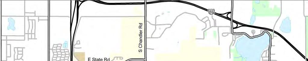
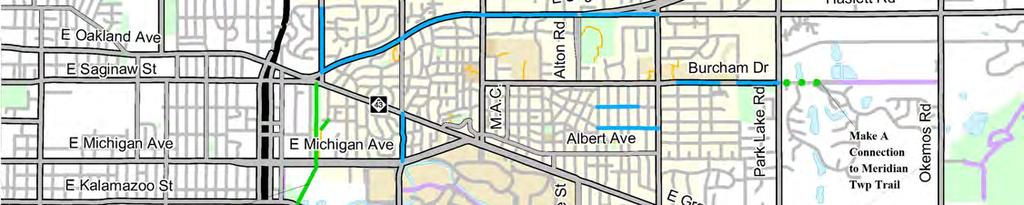
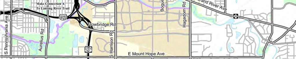
222 Pathway Facilities Public Input Legend: 218

223 Bicycle Facilities Public Input Legend: 219
224 Non-motorized Priorities Public Input Legend: 1. State Road Connects to Northern Tier Trail but has Narrow Paved Shoulders that are Difficult to Bike on. 2. Desire for Pedestrian and Bike Access Across I-127 to the Eastwood Towne Center. 3. Desire to Connect the Northern Tier Trail with the Downtown and Campus. 4. No Easy Place to Cross Along Saginaw St.; Sidewalks and Bike Lanes are Desired. 5. Difficult Intersection to Cross for Bicyclist and Pedestrians. 6. Difficult Intersection for Bicyclist and Pedestrians to Access Frandor Shopping Center. 7. Michigan Ave is Difficult to Cross and there is a Desire for Bike Lanes. 8. The Sidewalks Along Harrison Road are too Close to the Curb and Very Narrow, Making it Difficult to Traverse. There is also a Desire for Bike Lanes along this Road. 9. Grand River Ave is Difficult to Navigate through Downtown East Lansing. There is a Desire For Bike Lanes. 10. Grand River Ave between Bogue St. and Hagadorn Rd. Presents Difficulties for both Pedestrians. and Bicyclist. There is a Desire for Wider Sidewalks, Additional Crosswalks, and Bike Lanes. 11. Difficult Intersection for Pedestrians and Bikers. Drivers Violate the No Turn on Red Signal. 220
225 Fall Workshop Public Input A Public Workshop was held on September 23, 2009 for the City of East Lansing Non-Motorized Plan. Twenty-five people attended. During the public workshop, participants were given the opportunity to give input and evaluate the plan. Each Participant was asked to rate how the plan addressed the top places of concern and project expectations that were identified during the spring workshop. Project Expectation Evaluation Results Places of Concern Evaluation Results Public Input Maps The following maps document the places of concern and priorities that where noted on the workshop maps. Road Crossings and Intersections Sidewalk Facilities Bike Route Facilites Bike Lane Facilities Nonmotorized Priorities 221
226 Project Expectations Evaluation Results Based on the top eight desired outcomes determined from the Spring Public Workshop, participants were asked to rate how well they thought the topics were addressed by the Non-motorized Plan. Overall, the participants felt the plan addressed the top issues with average ratings of 3 or 4. Listed below are the numbers of votes for each rating. Does NOT address the issue at all Thoroughly addresses the issue Average Rating 1. Easy and Safe Bike / Pedestrian Transportation System that Connects to the Key Destination in the City 2. More / Improved Crosswalks, Especially Along Major Roads More Sidewalks, Especially Along Major Roads More Accessible Bike Racks and Bike Parking Areas Designated Bike Routes with Signage Cars, Bicycles and Pedestrians Coexist Connections to Lansing River Trail and Other Existing Trails 8. Connect Surrounding Outer Communities to the Downtown In addition to rating the top desired outcomes, participants were asked to specifically describe what could help the plan address these concerns better. Listed below are there responses. Get MSU, Meridian Twp Staff and interested residents involved to help improve inter-community connectivity and support. The plan look great, but worried about the process by which decisions are made, we need action and not endless debate allowing opposition from numerous interest groups. Plan needs more specific and stronger recommendations for bike racks. The public workshop did not get into policy and other details in regards to statements 4 (more accessible bike racks and bike parking areas) and number 6 (Cars, Bicycles and Pedestrians Coexist). Not sure if MAC is the best route through the Bailey neighborhood to downtown and MSU. Would rather see bicyclist diverted to Collingwood and reducing traffic in that area. The policy development and education/marketing sections MUST include rule and enforcement activities that move bicycling from more utilization of a toy to a legitimate road user with normalized behavior (light use, signal use, compliance with traffic signals, unambiguous policy on lane or sidewalk use) moving bicycling to a legitimate transportation mode, not just a recreational activity. Address Beech Street between Gunson and Hagadorn in a better fashion (consider idea of one-way street) 222
227 Places of Concern Evaluation Results Based on the top eleven places of concern determined from the Spring Public Workshop, participants were asked to rate how well they thought the topics were addressed by the Non-motorized Plan. Overall, the participants felt the plan addressed the top issues with average ratings of 3 and 4. Listed below are the numbers of votes for each rating. Does NOT address the issue at all Thoroughly addresses the issue Average Rating 9. Grand River Between Bogue and Hagadorn - Pedestrian Crossing Needed 10. Crossing US-127 to Commercial Center/Eastwood- There is Currently No Pedestrian Crossing Over the Expressway 11. Grand River Near Frandor Bike Lane Ends, Need Better Way to Get to Frandor/Lansing 12. Saginaw- Difficult to Cross Entire Stretch of Road, Lacking Pedestrian Crossings and Sidewalks Harrison Road- Needs Bike Lanes State Road Road Connects to Northern Tier Trail but has Narrow Shoulders 15. Northern Tier Trail Add Connections to Neighborhoods and Campus Michigan Ave- Needs Bike Lanes Grand River Ave and Hagadorn Intersection Hard to Cross, Drivers Don t Follow No Turn on Red 18. Grand River Ave- Difficult Navigating Through East Lansing on a Bike 19. Harrison Rd at Saginaw Hard to Cross by Bike/Pedestrian In addition to rating the top places of concern, participants were asked to specifically describe what could help the plan address these concerns better. Listed below are there responses. Bogue Crossing Inadequate Another place of concern- cycling through Harrison at Service Dr and Trowbridge Road Struggling between the ideas of a proposal verses a plan. A plan implies action. None of this seems guaranteed to happen and we want action. US-127 Interchange needs to be changed to accommodate Pedestrians. Northern Tier Trail is missing connections to the Tamarist Neighborhood. Concern from Pinecrest neighborhood regarding Fine Park. Neighbors who live on the park edge do not want a paved path through the park, and there are concerns about the lack of current maintenance. Michigan Ave west of Harrison Road needs pedestrian crossing. 223
228 Priorities During the Public Workshop, participants were separated into 6 different groups. Each group was given a large map of the preliminary network plan and was asked to review the plan and provide comments. In addition, each group was asked to circle there top three priorities for the network plan based on the following categories; Crossing Improvements, Bike Lane Extensions, Sidewalk Extensions, and Proposed Bike Routes. The following responses are listed below. Group 2 (no group 1): Crossing Improvements Grand River and Bogue, Grand River and Hagadorn, Grand River and Abbot Bike Lane Improvements Harrison Rd between Grand River and Michigan, Harrison Rd Between Saginaw and Lake Lansing, Albert Ave Hagadorn to MAC Sidewalk Improvements Lake Lansing between Hagadorn and Towar Ave, Harrison Rd between Saginaw and Woodingham Dr, Burcham Dr between John R St and Park Lake Road Group 3: Crossing Improvements Bike Lane Improvements Bike Route Improvements Grand River and Division, Grand River and Hagadorn, Saginaw and Abbot Harrison Rd between Grand River and Michigan, Albert Ave Entire Length Proposed bicycle boulevard connecting Northern Tier Trail to Downtown/MSU Group 5 (no group 4): Crossing Improvements Bike Lane Improvements Grand River and Gunson, Abbot Rd at the Northern Tier Trail, Saginaw and Hichingpost Rd Michigan Ave, Albert Ave Between Abbot and Collingwood Dr Sidewalk Improvements Saginaw Street between Abbot Road and Alton Road, Gap in Sidewalk on Coolidge Road, Lake Lansing between Hagadorn and Abbot Group 6: Crossing Improvements Grand River and Coolidge Bike Lane Improvements Sidewalk Improvements Traffic Circle at Burcham and Hagadorn, Traffic Circle at Grand River Ave and Hagadorn, Michgian Ave, Albert Ave between Abbot and Collingwood Saginaw Street between Hitchingpost Rd and Hagadorn 224
229 Group 7: Crossing Improvements Saginaw Bike Lane Improvements River, Alton Rd Sidewalk Improvements Road Bike Route Improvements Woodside Dr and Hagadorn, Kensington Rd and Michigan Ave, White Pond Rd and Abbot Rd between Grand River and Albert, Harrison Rd Between Michigan Ave and Grand Beech St between Gunson St and Hagadorn, Saginaw Street between Abbot Rd and Alton Trail through Patriarche Park Group 9 (no group 8): Crossing Improvements Bike Lane Improvements Sidewalk Improvements Bike Route Improvements Snyder Rd and Grand River Abbot Road Between Grand River and Albert Ave Beech St between Gunson St and Hagadorn Trail through Albert A White Park 225
230 Map Notes During the workshop participants were encouraged to note areas of concern on the workshop maps. Documented below is a list of these comments. Trail access to Tamarisk Neighborhood needed. 3-4 shoulders do not qualify as bike lanes on Mt. Hope Ave Pedestrian Mall a possibility on M.A.C. Need Improvements at Saginaw / Hagadorn Intersection Bogue / Grand River needs to be redesigned for Pedestrians and Bicycles Collingwood needs to be added to the Bike Routes to get to Campus Wildwood Dr is a better alternative for the bike route system, especially getting across Harrison Rd A Hybrid Pedestrian Signal is a good solution for the intersection of Touraine Ave and Saginaw St Poor Visibility Crossing MAC at Linden St Sharrow or Shared use Arrow suggested on Albert Rd in place of a contra-flow bike lane. Wider Sidewalk on Albert Place Hyprid Pedestrian Signal across from Bus Stop on Hagadorn Rd. A Hybrid Pedestrian Signal is a good solution for the intersection of Saginaw and Hichingpost Rd Linden Street Bike Route has a lot of stop signs for a bike route. There are mixed opinions as to whether a path should be construction through Henry Fine Park. Some are concerned with pathway going through Henry Fine Park, due to woodland and pond. Mixed Opinions as to weather a contra-flow bike lane with one way street traffic would be a good solution. Alternative bike route on Old Hickory Ln was suggested instead of Hitchingpost Rd. Aternative bike route on Blanchette Dr was suggested in place of Farwood Dr. There are concerns about heavy traffic at the Grand River Ave and Coolidge Intersection. If Albert becomes a one-way, traffic may be diverted into neighborhood and down Gunson which has a proposed bike route. MAC or Collingwood would be good Bike Bouldevards. Lexington, Kenberrry and Spartan could all be good bike route facilities as long as Hybrid Pedestrian Signal align with their crossings at major roads. Will bicycles be incorporated into the new east village project? Suggested to Add sidewalks instead of colored bike lanes to Beech St. Suggestion to place Car to Bike Parking facility at Patriarche Park. Concern as to whether the proposed Hybrid Pedestrian Signal would be feasible at the intersection of Saginaw and Hichingpost Rd. Conceptual extension of the Northern Tier Trail through the Sod Farms is a great idea, so the pathway will be extended when future development occurs. Concern with the Hybrid Pedestrian Signals that are proposed along Saginaw Street since the speed is 45mph. Concern with Bike Route Crossing at Northlawn and Harrison due to poor visibility, Widlwood Dr was suggested as the better crossing. Construction a path between Harrison rd and Coolidge rd is a good idea. The proposed pathway extension through Albert A White memorial park was seen as being a necessary part of the trails development. Suggestion to add Stepping Stones Montessori School to Map. Suggestion to make Beech St between Gunson and Hagadorn a one-way street to accomadate sidewalks, or put in colored bike lanes, but don t label them as such. Suggestion to add Islamic school to map. 226


231 Road Crossings Public Input Legend: These road crossing were all noted as areas of concern. 227
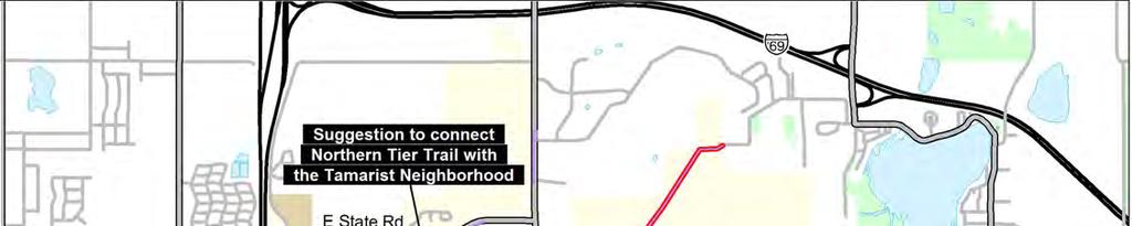
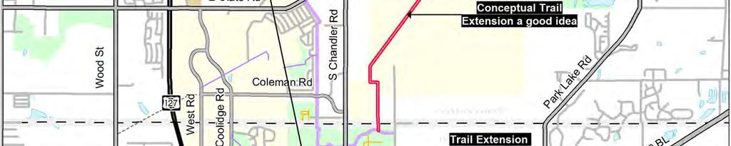
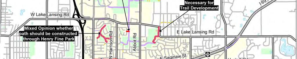
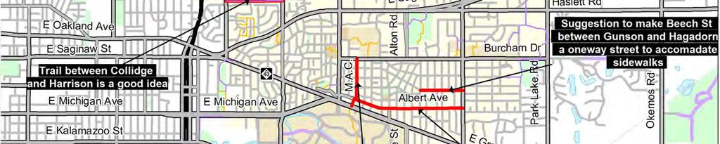
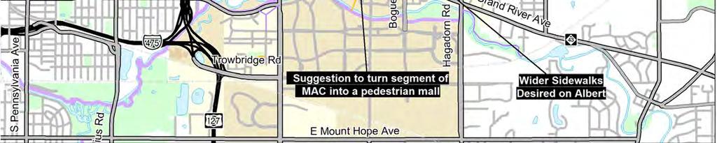
232 Pedestrian Facilities Public Input Legend: 228

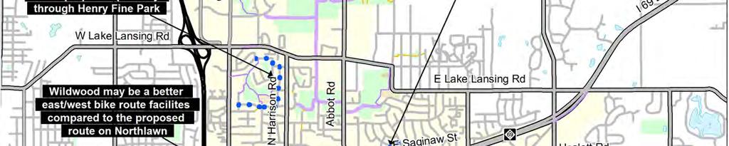
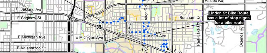
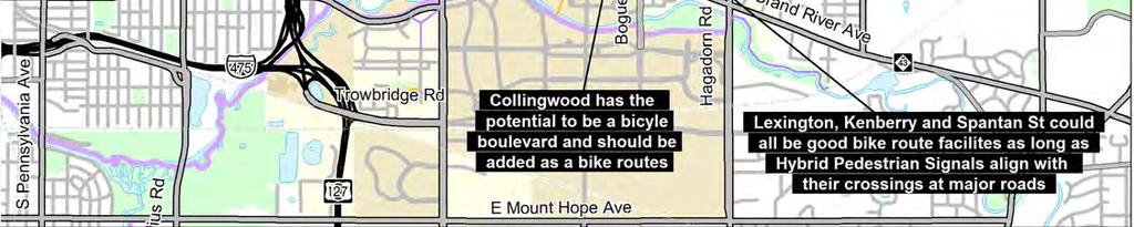
233 Bicycle Route Facilities Public Input Legend: 229


234 Bicycle Lane Facilities Public Input Legend: 230


235 Non-motorized Priorities Public Input Legend: The following priorities were identified by more than one group: Priority Road Crossings - Grand River and Hagadorn Intersection, Grand River and Abbot Road Intersection Priority Bike Lane- Harrison Rd Between Grand River and Michigan Ave, Albert Road, Michigan Ave, Abbot Rd Between Grand River and Albert Priority Sidewalk - Lake Lansing Rd Between Abbot and Hagadorn, Saginaw Between Abbot and Alton Beech Street Between Gunson and Hagadorn 231
Physical Implications of Complete Streets Policies
 Presentation Overview Physical Implications of Complete Norm Cox, ASLA, LLA Landscape Architect Ann Arbor, Michigan, 10:45 to Noon What Are Complete Streets? What Matters to Bicyclists and Pedestrians
APPENDIX A: Complete Streets Checklist DRAFT NOVEMBER 2016
 APPENDIX A: Complete Streets Checklist DRAFT NOVEMBER 2016 Complete Streets Checklist MetroPlan Orlando s Complete Streets Checklist is an internal planning tool for staff to further implementation of
GIS Based Data Collection / Network Planning On a City Scale. Healthy Communities Active Transportation Workshop, Cleveland, Ohio May 10, 2011
 The Purpose of GIS Based Network Planning GIS Based Data Collection / Network Planning Healthy Communities Active Transportation Conference Tuesday, May 10, 2011 10:00 AM Norman Cox, LLA, ASLA. Ann Arbor,
GIS Based Non-Motorized Transportation Planning APA Ohio Statewide Planning Conference. GIS Assisted Non-Motorized Transportation Planning
 The Purpose of GIS Assisted Network GIS Assisted Non-Motorized Transportation 2011 APA Ohio Statewide Conference Friday, 10:45 AM to Noon Focus on near-term projects wwwgreenwaycollabcom The purpose of
Broad Street Bicycle Boulevard Design Guidelines
 Broad Street Bicycle Boulevard Design Guidelines Building from the strategies introduced in the 2013 Bicycle Transportation Plan and community input received thus far, City Transportation Staff have identified
Active Transportation Facility Glossary
 Active Transportation Facility Glossary This document defines different active transportation facilities and suggests appropriate corridor types. Click on a facility type to jump to its definition. Bike
Agenda. Overview PRINCE GEORGE S PLAZA METRO AREA PEDESTRIAN PLAN
 PRINCE GEORGE S PLAZA METRO AREA PEDESTRIAN PLAN May 28, 2008 Agenda Welcome and introductions Project overview and issue identification Planning context and strengths Design challenges and initial recommendations
City of Novi Non-Motorized Master Plan 2011 Executive Summary
 City of Novi Non-Motorized Master Plan 2011 Executive Summary Prepared by: February 28, 2011 Why Plan? Encouraging healthy, active lifestyles through pathway and sidewalk connectivity has been a focus
ACTIVE TRANSPORTATION
 ACTIVE TRANSPORTATION Mobility 2040 Supported Goals Improve the availability of transportation options for people and goods. Support travel efficiency measures and system enhancements targeted at congestion
Appendix 3 Roadway and Bike/Ped Design Standards
 Appendix 3 Roadway and Bike/Ped Design Standards OTO Transportation Plan 2040 4/20/2017 Page A3-1 Adopted Standards The adopted OTO Design Standards and Major Thoroughfare Plan are contained herein.
Omaha s Complete Streets Policy
 Omaha s Complete Streets Policy (Adopted August 2015) VISION To create great places and enhance our quality of life, the City of Omaha will provide safe, accessible streets for all users. Complete Streets
Appendix T CCMP TRAIL TRAFFIC & TRANSPORTATION DESIGN STANDARD
 Appendix T CCMP 3.3.4 TRAIL TRAFFIC & TRANSPORTATION DESIGN STANDARD 3.3.4 Trail Traffic and Transportation Design Multi-use trails have certain design standards, which vary depending on the agency that
Planning Guidance in the 2012 AASHTO Bike Guide
 Planning Guidance in the 2012 AASHTO Bike Guide Presentation by: RJ Eldridge Peter Lagerwey August 22, 2012 WEBINAR 2: PLANNING GUIDANCE IN THE 2012 AASHTO BIKE GUIDE Today s Webinar Significant Updates
REGIONAL BICYCLE AND PEDESTRIAN DESIGN GUIDELINES
 REGIONAL BICYCLE AND PEDESTRIAN DESIGN GUIDELINES November 16, 2011 Deb Humphreys North Central Texas Council of Governments Bicycle and Pedestrian Advisory Committee Snapshot of the Guide 1. Introduction
CONNECTING PEOPLE TO PLACES
 CONNECTING PEOPLE TO PLACES 82 EAST BENCH MASTER PLAN 07 Introduction The East Bench transportation system is a collection of slow moving, treelined residential streets and major arteries that are the
CITY OF COCOA BEACH 2025 COMPREHENSIVE PLAN. Section VIII Mobility Element Goals, Objectives, and Policies
 CITY OF COCOA BEACH 2025 COMPREHENSIVE PLAN Section VIII Mobility Element Goals, Objectives, and Policies Adopted August 6, 2015 by Ordinance No. 1591 VIII MOBILITY ELEMENT Table of Contents Page Number
HARRISON STREET/OAKLAND AVENUE COMMUNITY TRANSPORTATION PLAN
 HARRISON STREET/OAKLAND AVENUE Community Workshop #4: Draft Plan Review December 3, 2009 D E S I G N, C O M M U N I T Y & E N V I R O N M E N T INTRODUCTIONS Key Project Staff: Alisa Shen, Project Manager,
Chapter 4 TOOLBOX AND SAMPLE BIKE BOULEVARD LAYOUT
 Chapter 4 TOOLBOX AND SAMPLE BIKE BOULEVARD LAYOUT OVERVIEW This chapter describes a cohesive set of strategies to create a bicycle boulevard, namely to make streets safer and more efficient for bicycle
Living Streets Policy
 Living Streets Policy Introduction Living streets balance the needs of motorists, bicyclists, pedestrians and transit riders in ways that promote safety and convenience, enhance community identity, create
TOWN OF PORTLAND, CONNECTICUT COMPLETE STREETS POLICY
 TOWN OF PORTLAND, CONNECTICUT COMPLETE STREETS POLICY I. VISION, GOALS & PRINCIPLES VISION To improve the streets of Portland making them safer and more accessible for all users including pedestrians,
Solana Beach Comprehensive Active Transportation Strategy (CATS)
") Solana Beach Comprehensive Active Transportation Strategy (CATS) 3.0 Goals & Policies The Solana Beach CATS goals and objectives outlined below were largely drawn from the Solana Beach Circulation Element
Solana Beach Comprehensive Active Transportation Strategy (CATS) 3.0 Goals & Policies The Solana Beach CATS goals and objectives outlined below were largely drawn from the Solana Beach Circulation Element
City of Birmingham Draft Multi-modal Transportation Plan
 City of Birmingham Draft Multi-modal Transportation Plan City Commission Public Hearing Monday, November 25, 2013 7:30 pm Norman Cox, PLA, ASLA The Greenway Collaborative, Inc. Ann Arbor, Michigan The
Off-road Trails. Guidance
 Off-road Trails Off-road trails are shared use paths located on an independent alignment that provide two-way travel for people walking, bicycling, and other non-motorized users. Trails specifically along
CHAPTER 16 PEDESTRIAN FACILITIES DESIGN AND TECHNICAL CRITERIA TABLE OF CONTENTS
 CHAPTER 16 PEDESTRIAN FACILITIES DESIGN AND TECHNICAL CRITERIA TABLE OF CONTENTS Section Title Page 16.1 General... 16-1 16.1.1 AASHTO Reference... 16-1 16.1.2 ADA Requirements... 16-1 16.2 Sidewalks...
PEDESTRIAN ACTION PLAN
 ATTACHMENT 2 CITY OF SANTA MONICA PEDESTRIAN ACTION PLAN CITY OF SANTA MONICA PEDESTRIAN ACTION PLAN This page intentionally left blank EXECUTIVE SUMMARY CHAPTER 1 EXECUTIVE SUMMARY Setting the Stage
5 Circulation & Parking
 5 Circulation & Parking Downtown Parking & Circulation Strategy. Downtown Wayne has a somewhat disconnected system of local public streets to connect downtown with the residential neighborhoods, and primary
PRINCE GEORGE S PLAZA METRO AREA PEDESTRIAN PLAN
 PRINCE GEORGE S PLAZA METRO AREA PEDESTRIAN PLAN May 28, 2008 Agenda Welcome and introductions Project overview and issue identification Planning context and strengths Design challenges and initial recommendations
This page intentionally left blank.
 This page intentionally left blank. COMMUNITY Coweta Community Overview Coweta Coweta, a residential community located in Wagoner County, is a suburb of Tulsa situated southeast of the metropolitan area
o n - m o t o r i z e d transportation is an overlooked element that can greatly enhance the overall quality of life for the community s residents.
 N o n - m o t o r i z e d transportation is an overlooked element that can greatly enhance the overall quality of life for the community s residents. 84 Transportation CHAPTER 11 INTRODUCTION Transportation
Non-Motorized Transportation 7-1
 Non-Motorized Transportation 7-1 Transportation facilities no longer mean just accommodating a vehicle powered by a combustion engine. Pedestrian and non-motorized facilities are important modes of travel
Safe Routes to School Action Plan Aberdeen, Idaho
 Background Aberdeen, Idaho is a largely agricultural community of nearly 2,000 people and is located in the southeast portion of the state on the western edge of American Falls Reservoir. The community
Chapter 2: Standards for Access, Non-Motorized, and Transit
 Standards for Access, Non-Motorized, and Transit Chapter 2: Standards for Access, Non-Motorized, and Transit The Washtenaw County Access Management Plan was developed based on the analysis of existing
5. RUNNINGWAY GUIDELINES
 5. RUNNINGWAY GUIDELINES These guidelines should be considered collectively when making runningway decisions. A runningway is the linear component of the transit system that forms the right-of-way reserved
NJDOT Complete Streets Checklist
 Background The New Jersey Department of Transportation s Complete Streets Policy promotes a comprehensive, integrated, connected multi-modal network by providing connections to bicycling and walking trip
Bicycle Boulevards and Neighborhood Greenways
 Bicycle Boulevards and Neighborhood Greenways Traffic Safety is Improving for Everyone 90 80 70 60 50 40 30 20 10 0 PORTLAND: TOTAL TRAFFIC FATALITIES 1986-2008 1986 1987 1988 1989 1990 1991 1992 1993
5 CIRCULATION AND STREET DESIGN
 5 CIRCULATION AND STREET DESIGN This chapter describes circulation and streetscape improvements proposed for the Northwest Chico Specific Plan Area. It includes detailed design specifications for existing
What Is a Complete Street?
 Session 5 Charleen Zimmer, AICP, Zan Associates May 5-7, 2010 What Is a Complete Street? May 2010 5-1 Not a Complete Street More of a Complete Street May 2010 5-2 Benefits of Complete Streets Safety for
Cycle Track Design Best Practices Cycle Track Sections
 Design Best Practices Sections It is along street segments where the separation and protection methods of cycle tracks offer more comfort than conventional bicycle lanes, and are more attractive to a wide
City of Albert Lea Policy and Procedure Manual 4.10 ALBERT LEA CROSSWALK POLICY
 4.10 ALBERT LEA CROSSWALK POLICY PURPOSE: Pedestrian crosswalks are an integral part of our transportation infrastructure. To be effective and promote safety, marked crosswalks must be installed after
Appendix A: Crosswalk Policy
 Appendix A: Crosswalk Policy Appendix A: Crosswalk Policy Introduction This citywide Crosswalk Policy is aimed at improving pedestrian safety and enhancing pedestrian mobility by providing a framework
On Road Bikeways Part 1: Bicycle Lane Design
 On Road Bikeways Part 1: Bicycle Lane Design Presentation by: Nick Jackson Bill Schultheiss, P.E. September 04, 2012 FOLLOW THE CONVERSATION ON TWITTER Toole Design Group is live tweeting this webinar
Watertown Complete Streets Prioritization Plan. Public Meeting #1 December 14, 2017
 Watertown Complete Streets Prioritization Plan Public Meeting #1 December 14, 2017 Goals for Public Meeting Overview of MassDOT Complete Streets Funding Program Educate the community on Complete Streets
FEDERAL HIGHWAY ADMINISTRATION APPLICATION
 FEDERAL HIGHWAY ADMINISTRATION APPLICATION REQUEST FOR PERMISSION TO EXPERIMENT WITH A BICYCLE BOX INTERSECTION TREATMENT Submitted by: City of Columbus Department of Public Service Date: June 26, 2009
TRAFFIC CALMING GUIDE FOR TORONTO CITY OF TORONTO TRANSPORTATION SERVICES DIVISION
 TRAFFIC CALMING GUIDE FOR TORONTO CITY OF TORONTO TRANSPORTATION SERVICES DIVISION CITY OF TORONTO TRANSPORTATION SERVICES DIVISION 2016 TRAFFIC CALMING GUIDE FOR TORONTO TABLE OF CONTENTS Introduction
Complete Streets Policy DAVID CRONIN, P.E., CITY ENGINEER
 Complete Streets Policy DAVID CRONIN, P.E., CITY ENGINEER Complete Streets City Commission adopted a Complete Streets policy in 2012 Complete Streets are road networks that are designed for all users:
Overview. Illinois Bike Summit IDOT Complete Streets Policy Presentation. What is a Complete Street? And why build them? And why build them?
 Overview Illinois Bike Summit IDOT Complete Streets Policy Presentation Aren Kriks, P.E. District One Bicycle Coordinator and Bureau of Programming Project Engineer History of Complete Streets IDOT Policy
Multimodal Through Corridors and Placemaking Corridors
 68 Multimodal Through Corridors and Placemaking Corridors Corridors have different functions in a region. Some corridors are used to get smoothly and rapidly through a region or to get quickly to major
City of Elizabeth City Neighborhood Traffic Calming Policy and Guidelines
 City of Elizabeth City Neighborhood Traffic Calming Policy and Guidelines I. Purpose: The City of Elizabeth City is committed to ensure the overall safety and livability of residential neighborhoods. One
NM-POLICY 1: Improve service levels, participation, and options for non-motorized transportation modes throughout the County.
 Transportation PRINCE WILLIAM COUNTY 2008 COMPREHENSIVE PLAN NON-MOTORIZED PLAN CONTENTS Goals, Policies, and Action Strategies Table 4 (Bike Facility Classifications and Descriptions) Table 5 (Bike Facility
CONNECTIVITY PLAN. Adopted December 5, 2017 City of Virginia Beach
 CONNECTIVITY PLAN Adopted December 5, 2017 City of Virginia Beach CONTENTS 1.0 Background & Purpose... 2 2.0 Existing Inventory & Analysis... 3 ViBe District Existing Walking Conditions... 4 3.0 ViBe District
RZC Appendix 8A Marymoor Subarea Street Requirements
 RZC Appendix 8A Marymoor Subarea Street Requirements For additional design details for Marymoor Subarea infrastructure, refer to the 2017 Marymoor Subarea Infrastructure Planning Report. STREET REQUIREMENTS
CITY OF BLOOMINGTON COMPLETE STREETS POLICY
 CITY OF BLOOMINGTON COMPLETE STREETS POLICY POLICY OBJECTIVE: The City of Bloomington will enhance safety, mobility, accessibility and convenience for transportation network users of all ages and abilities,
Prince George s County plans, policies, and projects
 Prince George s County plans, policies, and projects Over 250 projects for trails, bikeways, designated bike lanes and sidewalk construction Trail projects that improve access to Metro Sidewalk and trail
Chapter 3: Multi-Modal Circulation and Streetscapes
 CHAPTER 3: MULTI-MODAL CIRCULATION AND STREETSCAPES Chapter 3: Multi-Modal Circulation and Streetscapes Overview Streetscape improvements have already been completed for Depot Street between Main Avenue
INTRODUCTION THOROUGHFARE SYSTEM CLASSIFICATIONS
 INTRODUCTION The thoroughfare plan will assist public officials in the development of a specialized system for efficient and safe movement of vehicular traffic while minimizing potential conflicts with
Overview. Existing Conditions. Corridor Description. Assessment
 Overview A study of the 23 rd Street corridor was undertaken to document the existing conditions, analyze traffic operations, and recommend remedies for deficient situations Although 23 rd Street is frequently
Proposed. City of Grand Junction Complete Streets Policy. Exhibit 10
 Proposed City of Grand Junction Complete Streets Policy Exhibit 10 1 City of Grand Junction Complete Streets Policy Vision: The Complete Streets Vision is to develop a safe, efficient, and reliable travel
Chapter 5 Future Transportation
 Chapter 5 Future Transportation The Future Land Use Plan identifies the desired land use designations. The land uses desired for Crozet depend, in large part, on the success of the transportation system,
Report. Typical Sections. City of Middleton, WI
 Report Typical Sections City of Middleton, WI December 2006 Report for City of Middleton, Wisconsin Typical Sections repared by: Traffic Associates LLC and STRAND ASSOCIATES, INC. 910 West Wingra Drive
INDOT Complete Streets Guideline & Policy
 INDOT Complete Streets Guideline & Policy INTRODUCTION The Complete Streets guidelines build upon multiple efforts and promote a multimodal transportation system that is integrated and sustains land use
Complete Streets. Designing Streets for Everyone. Sarnia
 Complete Streets Designing Streets for Everyone Sarnia Complete Streets ~ Sarnia ~ 2018 Introduction Our City is made up of a network of streets that we use to go for a walk, cycle to work, drive to the
Implementing Complete Streets in Ottawa. Project Delivery Process and Tools Complete Streets Forum 2015 October 1, 2015
 Implementing Complete Streets in Ottawa October 1, 2015 The Essentials Complete Streets Implementation Framework will become part of the routine delivery of City transportation projects Approach uses every
MEMORANDUM. Date: 9/13/2016. Citywide Crosswalk Policy
 MEMORANDUM Date: 9/13/2016 Re: Citywide Crosswalk Policy Foreword Through the s Circulation Element and Complete Streets Policy, it is the City s goal to promote walking trips and provide safe facilities
Bicycle and Pedestrian Chapter TPP Update Overview. TAB September 20, 2017
 Bicycle and Pedestrian Chapter TPP Update Overview TAB September 20, 2017 Bicycling & Walking in the Twin Cities Where are we now? The Bike-Pedestrian system Current trends New developments Where are we
COWETA HIGH SCHOOL AND EAST HIGHWAY 51
 COWETA HIGH SCHOOL AND EAST HIGHWAY 51 Lack of sidewalks along Ben Lumpkin Rd. Lack of crosswalks and ramps at intersection. Hwy 51 is wide to cross as a pedestrian. No ADA compliance or connection to
Madison Urban Area and Dane County. Bicycle Transportation Plan Summary. September Introduction. Bicycle Plan Scope and Planning Process
 Bicycle Transportation Plan Summary Madison Urban Area and Dane County Introduction September 2000 Bicycling is an important mode of transportation in the Madison urban area and countywide that is available
Goal 3: Foster an environment of partnerships and collaboration to connect our communities and regions to one another.
 Non-Motorized Transportation Plan (NMTP) Draft Vision, Goal and,, Tri-County Regional Planning Commission (TCRPC) Purpose The purpose of the Tri-County Regional Planning Commission (TCRPC) Non-Motorized
City of Saline. Complete Streets Ordinance
 City of Saline Complete Streets Ordinance September 13 and 20, 2010 CARLISLE/WORTMAN ASSOCIATES What Are Complete Streets? Complete streets are designed to serve everyonemotorists as well as pedestrians
INDEX. Geometric Design Guide for Canadian Roads INDEX
 Acceleration lane, see Lanes, Acceleration Access, 8.1 Access Management and Functional Classification 8.2 Access Management by Design Classification 8.3 Access Configuration 8.4 Building Set-Back Guidelines
2014 Wisconsin Tribal Transportation Conference. Matt Halada Transportation Planner NE Region
 2014 Wisconsin Tribal Transportation Conference Matt Halada Transportation Planner NE Region Implementing Wisconsin s Pedestrian and Bicycle Accommodations Law (Complete Streets) Tools and methods for
Recommended Roadway Plan Section 2 - Land Development and Roadway Access
 Recommended Roadway Plan Section 2 - Land Development and Roadway Access SECTION 2 Land Development and Roadway Access 2.1 Land Use and Access Management The Federal Highway Administration (FHWA) defines
CITY OF SARATOGA SPRINGS PEDESTRIAN CROSSING TOOLBOX
 CITY OF SARATOGA SPRINGS PEDESTRIAN CROSSING TOOLBOX This toolbox is to be used to guide pedestrian crossing improvements within the City of Saratoga Springs. Details for each crossing type are provided.
Chapter 2. Bellingham Bicycle Master Plan Chapter 2: Policies and Actions
 Chapter 2 Bellingham Bicycle Master Plan Chapter 2: Policies and Actions Chapter 2: Policies and Actions The Bicycle Master Plan provides a road map for making bicycling in Bellingham a viable transportation
Complete Street Analysis of a Road Diet: Orange Grove Boulevard, Pasadena, CA
 Complete Street Analysis of a Road Diet: Orange Grove Boulevard, Pasadena, CA Aaron Elias, Bill Cisco Abstract As part of evaluating the feasibility of a road diet on Orange Grove Boulevard in Pasadena,
Balancing Operation & Safety for Motorized and Non-Motorized Traffic
 Balancing Operation & Safety for Motorized and Non-Motorized Traffic Brian Willham, PE, PTOE Iowa Director - MOVITE June 30, 2014 Learning Objectives: When & Why should we measure the performance of complete
Duwamish Way-finding and CTR Report
 V. North Tukwila When the North Tukwila Manufacturing and Industrial Center was designated in 1992 as part of the region s land use and transportation plan, the plan called for the area to set a light-rail
Executive Summary Route 30 Corridor Master Plan
 Route Corridor Master Plan Project Overview The Route Corridor Master Plan is a coordinated multimodal transportation and land use plan for the entire stretch of Route through East Whiteland Township,
M-58 HIGHWAY ACCESS MANAGEMENT STUDY Mullen Road to Bel-Ray Boulevard. Prepared for CITY OF BELTON. May 2016
 M-58 HIGHWAY ACCESS MANAGEMENT STUDY Prepared for CITY OF BELTON By May 2016 Introduction Missouri State Highway 58 (M-58 Highway) is a major commercial corridor in the City of Belton. As development has
Coquitlam Cross-town Bike Route Improving Bicycle Facilities in a Mature Suburban Environment
 Coquitlam Cross-town Bike Route Improving Bicycle Facilities in a Mature Suburban Environment Sarah Rocchi, Vice-President, Projects, Opus International Consultants (Main Presenter) Catherine Mohoruk,
4 Goals, Objectives & Actions
 Chapter4 4 This chapter presents goals, objectives, and recommended actions to support the vision of making Overland Park a safer and easier place to ride a bicycle. 35 4.1 Recommendations Structure The
G AT E WAY PLAN. Community BRIEFING KIT GATEWAY BIKE
 G AT E WAY PLAN GATEWAY BIKE Community BRIEFING KIT PLAN August 2016 TABLE OF CONTENTS INTRODUCTION... 1 THE BENEFITS OF A BIKEABLE COMMUNITY... 2 ECONOMY...2 SAFETY...3 HEALTH...3 HOUSEHOLD SPENDING...3
City of Wayzata Comprehensive Plan 2030 Transportation Chapter: Appendix A
 A1. Functional Classification Table A-1 illustrates the Metropolitan Council s detailed criteria established for the functional classification of roadways within the Twin Cities Metropolitan Area. Table
Dr. M.L. King, Jr. Street North Complete Streets Resurfacing Opportunities HOUSING, LAND USE, AND TRANSPORTATION COMMITTEE MARCH 22, 2018
 Dr. M.L. King, Jr. Street North Complete Streets Resurfacing Opportunities HOUSING, LAND USE, AND TRANSPORTATION COMMITTEE MARCH 22, 2018 What s Happening The City plans to mill and resurface Dr. M.L.
CITY OF SAINT JOHN TRAFFIC CALMING POLICY
 CITY OF SAINT JOHN TRAFFIC CALMING POLICY VERSION: 1.0 April 10, 2012 Pedestrians, Cyclists and Motorists Sharing Street Spaces CONTENTS INTRODUCTION... 3 POLICY GOAL... 3 POLICY OBJECTIVES... 3 GUIDING
Transportation Planning Division
 Transportation Planning Division Presentation Outline Study Tasks Recap of Previous Meetings Data Collected Focus Areas within Study Limits Design Principles Tool Box Recommended Concepts Schedule Moving
West Dimond Blvd Upgrade Jodhpur Street to Sand Lake Road
 West Dimond Blvd Jodhpur St to Sand Lake CSS Transportation Project Summary Municipality of Anchorage Project # 05 005 Project Manager: John Smith, P.E. (MOA PM&E) Project Administrator: Julie Makela,
This page intentionally left blank.
 This page intentionally left blank. COMMUNITY Glenpool Community Overview Glenpool Glenpool is a city of nearly 12,000 residents located in Tulsa County southwest of Tulsa and Jenks. The city is growing
Public Information Centre
 WELCOME Public Information Centre Father Tobin Road Lougheed Middle School - Library Wednesday November 7, 2012 7:00 p.m.to 9:00 p.m. Please sign in Neighbourhood Traffic Calming Guide Background The City
2.0 LANE WIDTHS GUIDELINE
 2.0 LANE WIDTHS GUIDELINE Road Engineering Design Guidelines Version 2.0.1 May 2018 City of Toronto, Transportation Services City of Toronto Page 0 Background In early 2014, Transportation Services initiated
Town of Mooresville, North Carolina Neighborhood Traffic Calming and Control Device Policy
 Town of Mooresville, North Carolina Neighborhood Traffic Calming and Control Device Policy Adopted January 6, 2014 Town of Mooresville Development Services Department TOWN OF MOORESVILLE NEIGHBORHOOD TRAFFIC
2.0 Existing Conditions
 20 2.0 Existing Conditions 2.1 Land Use, Future Growth Patterns, Physical Barriers Geographic Overview Sutter County s land use pattern is characterized by extensive agricultural areas, significant natural
Memo. Introduction. Memphis STP Pedestrian Sidewalk Project
 Memo Memphis STP Pedestrian Sidewalk Project To: Kyle Wagenshutz, City of Memphis From: Matthew Berkow, Collin Chesston, and Anne Eshleman, Alta Planning + Design Date: June 2014 Re: Photo Inventory Introduction
Gordon Proctor Director Policy on Accommodating Bicycle and Pedestrian Travel on ODOT Owned or Maintained Facilities
 Approved: Policy: 20-004(P) Responsible Office: Planning Gordon Proctor Director Policy on Accommodating Bicycle and Pedestrian Travel on ODOT Owned or Maintained Facilities I. POLICY STATEMENT: This policy
Houma-Thibodaux Metropolitan Planning Organization STP<200K Funding Application APPLICATION
 APPLICATION HOUMA-THIBODAUX METROPOLITAN PLANNING ORGANIZATION (HTMPO) FOR SURFACE TRANSPORTATION PROGRAM (STP
General Design Factors
 Chapter 3: 3-1.0 Introduction General Design Factors Mn/DOT s goals include encouraging and accommodating safe bicycling. From a design perspective, these goals are achieved by first having an understanding
JCE 4600 Transportation Engineering. Traffic Control
 JCE 4600 Transportation Engineering Traffic Control Human Factors Primary Driving Tasks NAVIGATION GUIDANCE CONTROL What makes a Traffic Control Device Effective? Fulfill a need Command Attention Convey
RESOLUTION NO ?? A RESOLUTION OF THE CITY OF NEPTUNE BEACH ADOPTING A COMPLETE STREETS POLICY
 RESOLUTION NO. 2018-?? A RESOLUTION OF THE CITY OF NEPTUNE BEACH ADOPTING A COMPLETE STREETS POLICY WHEREAS, safe, convenient, and accessible transportation for all users is a priority of the City of Neptune
WELCOME Public Information Centre
 WELCOME Public Information Centre Fernforest Drive Brampton Soccer Centre Community Room #2 Tuesday January 19, 2016 6:30 p.m.to 9:00 p.m. Please sign in Neighbourhood Traffic Calming Guide Background
Perryville TOD and Greenway Plan
 Perryville TOD and Greenway Plan Greenway Glossary Pathway: A bicycle and pedestrian path separated from motorized vehicular traffic by an open space, barrier or curb. Multi-use paths may be within the
Active Transportation Infrastructure Investment A Business Case
 Active Transportation Infrastructure Investment A Business Case In 2016, the Real Estate Foundation awarded the Capital Regional District a $50,000 grant for Shifting Gears: Land Use Change through Active