ROAD SAFETY AUDIT. Santilli Circle and Sweetser Circle. Municipality of Everett. March 10, Prepared For: MassDOT
|
|
|
- Marjorie Hardy
- 6 years ago
- Views:
Transcription
1 ROAD SAFETY AUDIT Santilli Circle and Sweetser Circle Municipality of Everett Prepared For: MassDOT On Behalf Of: WYNN Design and Development Prepared By: AECOM 250 Apollo Drive Chelmsford, MA
2 Road Safety Audit Santilli Circle and Sweetser Circle Prepared by AECOM Table of Contents Contents Background... 1 Project Data... 1 Project Location and Description... 2 Audit Observations and Potential Safety Enhancements... 7 Summary of Road Safety Audit List of Appendices Appendix A. Appendix B. Appendix C. Appendix D. RSA Meeting Agenda RSA Audit Team Contact List Detailed Crash Data Road Safety Audit References List of Figures Figure 1: Locus Map Santilli Circle, Everett... 5 Figure 2: Locus Map - Sweetser Circle, Everett... 6 List of Tables Table 1: Participating Audit Team Members... 2 Table 2: Estimated Time Frame and Costs Breakdown Table 3: Potential Safety Enhancement Summary Santilli Circle Table 4: Potential Safety Enhancement Summary Sweetser Circle... 19
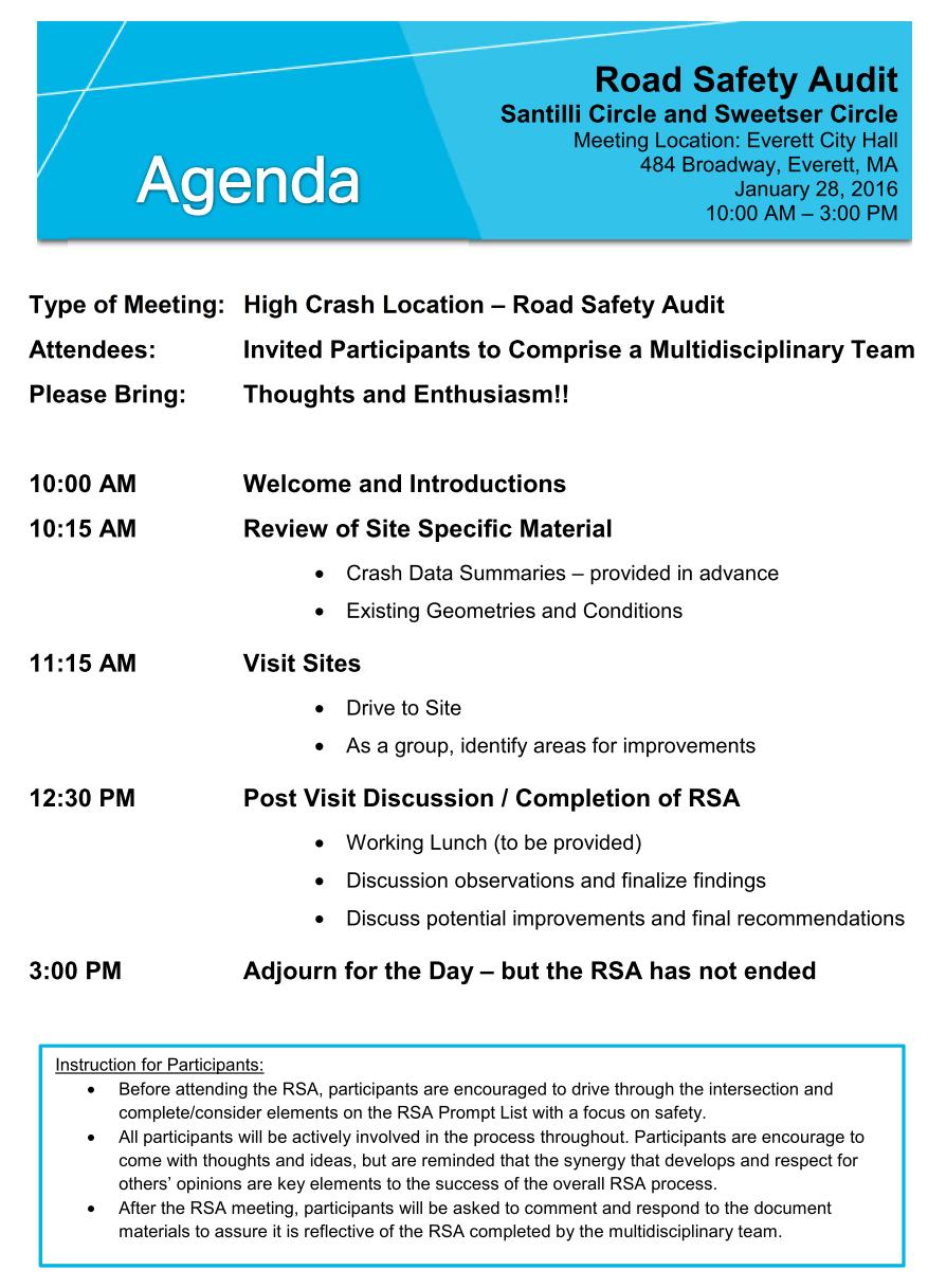
3 Road Safety Audit Santilli Circle and Sweetser Circle Prepared by AECOM Background The Federal Highway Administration (FHWA) defines a Road Safety Audit (RSA) as the formal safety examination of an existing or future road or intersection by an independent, multidisciplinary team. The purpose of an RSA is to identify potential safety issues and possible opportunities for safety improvements considering all roadway users. This RSA evaluates the Santilli Circle and Sweetser Circle rotaries along Route 16 Revere Beach Parkway (RBP) in Everett, Massachusetts. Route 16-RBP is under the jurisdiction of the Department of Conservation and Recreation (DCR). A safety audit was scheduled for these rotaries as part of the Massachusetts Environmental Protection Agency (MEPA) approval process for the proposed Wynn Everett Project. MassDOT has identified two Highway Safety Improvement Program (HSIP) crash clusters between 2011 and 2013 at Santilli Circle and one HSIP cluster at Sweetser Circle. A key objective of the RSA is to identify both short-term and long-term safety improvements that can be made throughout the corridor and or at the subject intersections. Project Data An RSA was completed for the rotaries on Thursday, January 28, The agenda for the RSA meeting held at Everett City Hall is provided in Appendix A of this report. As shown below in Table 1, the audit team consisted of a multidisciplinary team with representatives from state, regional and local agencies providing expertise in the engineering, planning, and maintenance fields. Contact information for the audit team members is provided in Appendix B of this report. Within the invitation sent on January 20, 2016 to each participant in the RSA, background material was provided. This information included collision diagrams and crash data summaries for the study locations. During the RSA meeting, these materials were reviewed as a group prior to the field visit to the locations. During the RSA field visit, various safety issues were observed and identified. Following the RSA field visit, the team returned to discuss additional concerns and potential solutions for the existing safety issues. Page 1
4 Road Safety Audit Santilli Circle and Sweetser Circle Prepared by AECOM Table 1: Participating Audit Team Members Audit Team Member Agency/Affiliation Derek Caldwell John Mastera Timothy Paris David Loutzenheiser Mark Abbott Val Soroka Jay Monty Julius Ofurie Al Carrier Chris Chaffee Dirk Grotenhuis Jeff Maxtutis MassDOT District 4 - Traffic MassDOT Highway Safety MassDOT District 4 - Projects MAPC Boston MPO/CTPS DCR City of Everett City of Everett Wynn Design and Development AECOM AECOM AECOM The crashes and collision diagrams were based on crashes reported by Mass State Police between January 2011 and December At Santilli Circle a total of 83 crashes were reported for the period between 2011 and Of these, 53 percent were rear-end crashes and 22 percent were angle crashes. Several rear-end crashes occurred when motorists were yielding or failed to yield. A total of 35 percent of the crashes occurred between Noon and 4:00 PM. Two bicycle crashes were recorded. The month with the highest percent of crashes was November (13 percent). The day with the highest percent of crashes was Tuesday (19 percent). Most crashes occurred in daylight hours with clear weather conditions and dry road surface. At Sweetser Circle a total of 56 crashes were reported for the period between 2011 and Of these, 56 percent were rear-end crashes and 21 percent were side swipe crashes. A total of 39 percent of the crashes occurred between 2:00 PM and 8:00 PM. One bicycle crash was recorded. The month with the highest percent of crashes was November (14 percent). A total of 16 percent of the crashes occurred on Tuesday, Thursday and Saturday. Most crashes occurred in daylight hours with clear weather conditions and dry road surface. Project Location and Description The Audit locations were as follows: Santilli Circle Route 16 (Revere Beach Parkway), Everett Sweetser Circle (Revere Beach Parkway), Everett Page 2
5 Road Safety Audit Santilli Circle and Sweetser Circle Prepared by AECOM Santilli Circle Santilli Circle is a rotary type intersection with signalized control where Route 16 intersects the rotary on the east and west sides. Route 16 and the rotary are classified as a Principal Arterial by MassDOT. Route 16 west of Santilli Circle carries approximately 73,500 vehicles per day (2011). During the Friday PM peak hour, approximately 6,340 vehicles enter the circle with a two-way traffic volume of approximately 5,500 vehicles on Route 16 west of the circle (2013). The posted speed limit on Route 16 is 35 MPH, but 25 MPH eastbound west of the circle. Route 16 is under the jurisdiction of the Massachusetts Department of Conservation and Recreation (DCR). MassDOT has identified two HSIP crash clusters between 2011 and 2013 at Santilli Circle. The traffic circle (rotary) itself consists of two lanes in one direction circulating counter-clockwise. The following lanes and intersection controls are provided at each approach to the rotary: Route 16 eastbound three through lanes, one right-turn lane and one right-turn slip lane, signal control Route 16 westbound two through lanes and one through-right lane, signal control Santilli Circle Connector westbound one lane entering rotary, Yield control Mystic View Road northbound - one lane entering rotary, uncontrolled Santilli Highway southbound one lane entering rotary, Stop control Santilli Circle interior three lanes in each direction The two traffic signals are coordinated with each other providing two signal phases. There are signalized pedestrian crosswalks across Route 16 (west side) eastbound and westbound, which run concurrently with the traffic movements. There are two pedestrian push button actuated signals: one on the westbound onramp on the west side of rotary and one on the eastbound right turn slip ramp on the west side. Unsignalized pedestrian crosswalks are provided at the Santilli Highway entrance and exit roads; Santilli Circle west of Kelvin Street connecting the MBTA bus stops; and at Kelvin Street. Sidewalks are provided on the outside of the rotary on the north side between Mystic View Road and Kelvin Street. There is an informal path worn through the center of the rotary on a northeast to southwest orientation. No bicycle facilities are provided at Santilli Circle. Figure 1 shows the Santilli Circle study area. Page 3
6 Road Safety Audit Santilli Circle and Sweetser Circle Prepared by AECOM Sweetser Circle Sweetser Circle is an unsignalized rotary type intersection. Route 16 under Sweetser Circle is classified as a Principal Arterial by MassDOT. Route 99 and Main Street are classified as Urban Principal Arterials. Route 99 south of Sweetser Circle carries approximately 40,400 vehicles per day (2005). During the Friday PM peak hour, over 3,500 vehicles enter the circle with a two-way traffic volume of approximately 2,340 vehicles on Route 99 south of the circle (2013). Sweetser Circle is under the jurisdiction of the Massachusetts Department of Conservation and Recreation (DCR). MassDOT has identified one HSIP crash cluster between 2011 and 2013 at Sweetser Circle The traffic circle (rotary) consists of one wide lane in one direction circulating counter-clockwise. However, traffic generally form two lanes driving within the rotary. All approaches entering the rotary are one lane, but traffic generally forms into two lanes under congested conditions. The following are the four approaches to the rotary, all under Yield control: Route 99 northbound Route 99 southbound Main Street southbound Santilli Circle Connector eastbound Except for crosswalks; there are no pavement markings within the rotary or on the approach roadways. There is push button actuated pedestrian signal on the Route 16 eastbound on-ramp on the southeast corner of the rotary. The signal provides flashing yellow and red ball beacons for both traffic and pedestrians when actuated. A DCR crossing guard is located at this crosswalk for one hour during the morning and afternoon peak hours. This crossing guard provides access for school children on Lower Broadway to schools located on upper Broadway. Unsignalized pedestrian crosswalks are provided across the Route 99 northbound and southbound, Main Street and Santilli Connector roadways. No bicycle facilities are provided at Sweetser Circle. Figure 2 shows the Sweetser Circle study area. Page 4

7 Road Safety Audit Santilli Circle and Sweetser Circle Prepared by AECOM Figure 1: Locus Map Santilli Circle, Everett Page 5

8 Road Safety Audit Santilli Circle and Sweetser Circle Prepared by AECOM Figure 2: Locus Map - Sweetser Circle, Everett Page 6
9 Road Safety Audit Santilli Circle and Sweetser Circle Prepared by AECOM Audit Observations and Potential Safety Enhancements During the RSA meeting prior to the field visit, a brief introduction of the RSA process and a summary of crash information was presented to the audit participants. Following this brief presentation, the members of the audit team were asked to discuss the existing issues that may affect safety within the study area. The audit team then visited the site as a group, at which time observations of various safety concerns and deficiencies were identified and documented. The audit observations identified and documented in this report, have been provided by audit participants or commenter s, and do not necessarily represent those of the report authors AECOM. Comments made by respondents have been reviewed to ensure the report is focused on current safety concerns/recommendations within the study area, are relevant to plans for the corridor, and relate to the goals of this RSA. Provided below is a list of the safety concerns and issues that were identified during the RSA within the study area. Santilli Circle Santilli Circle has a non-traditional rotary configuration with two traffic signals at the intersections with Route 16. This presents unique issues in terms of safety and operations. Much of the MUTCD guidance on roundabouts applies to this configuration. The issues observed are summarized in the following areas which proceed counter-clockwise around Santilli Circle: General Santilli Circle Connector Santilli Highway Route 16 west Mystic View Road/Gateway Center Route 16 east Santilli Circle interior General There are no bicycle facilities provided at Santilli Circle. Most pedestrian wheelchair ramps lack detectable warning devices. The new Woods Memorial Bridge will include bicycle facilities. There are no roundabout directional arrow signs. There are no yield markings on the unsignalized rotary approaches of Mystic View Road northbound and Santilli Circle Connector westbound. Pavement distress such as rutting and shoving were observed. Lack of guide signs directing motorists to roadway intersecting the rotary. Page 7


10 Road Safety Audit Santilli Circle and Sweetser Circle Prepared by AECOM Santilli Circle Connector The connection between the MBTA westbound bus stop and the Best Buy store to the north is not ADA compliant. The sidewalk abruptly ends and a staircase does not connect to the sidewalk. Sight distance is limited for westbound vehicles approaching the crosswalk across Santilli Circle Connector west of Kelvin Street. The crosswalk distance is long across Santilli Circle Connector Road and vehicle speeds appear to be high. The crosswalk receives moderate volumes because it serves MBTA bus stops on both sides of Santilli Circle Connector. There are no pedestrian crosswalk signs and detectable pedestrian warning devices. Image 1: Lack of ADA sidewalk to/from Best Buy parking lot There is a Yield sign for eastbound motorists making the right turn form the circle to Santilli Circle Connector. The sign is not needed because there is no merging traffic. There is no guide signage for motorists exiting the rotary onto Santilli Circle Connecter. Image 2: Lack of adequate sight distance for westbound Santilli Circle Connector approaching crosswalk Image 3: Lack of Guide Sign to Route 99 Santilli Highway Vehicle queues back from signal blocking the Santilli Highway approach which makes it difficult for motorists to maneuver around stopped vehicles. Route 16 West Westbound vehicles from rotary merge with westbound Route 16 vehicles. Vehicles weave to align in downstream lanes. Lack of pavement markings and signage contribute to rear-end and sideswipe crashes. The pole-mounted traffic signal for westbound traffic exiting the rotary is out of order. There are two overhead green arrow signal beacons which are confusing since there is only one designated through lane. This signal is intended to be actuated only by a pedestrian pushing the button. Page 8
 signals. High vehicle speeds on the Route 16 westbound merge combined with unexpected pedestrian crossings is a potential safety issue.")


11 Road Safety Audit Santilli Circle and Sweetser Circle Prepared by AECOM There is a long crosswalk across Route 16. Pedestrian walk times are not sufficient to cross Route16 in one cycle. No countdown or accessible pedestrian signal (APS) signals. High vehicle speeds on the Route 16 westbound merge combined with unexpected pedestrian crossings is a potential safety issue. There is an existing guide sign for eastbound motorists indicating right turn to Mystic View Road and Santilli Circle to Rt. 99. However, the sign is located on the outside right turn lane and does not give motorists enough warning to be in the inside right turn lane to access the Rotary and Rt. 99. The pedestrian push button is broken on the west side of the eastbound right-turn slip ramp. The pedestrian signal across the slip ramp should operate in a pre-emption mode since it is not coordinated with traffic signal. The southbound rotary approach queues make it difficult for vehicles from Santilli Highway to enter the rotary and for vehicles to exit the rotary onto Route 16 westbound. Image 4: Route 16 Westbound Merge and Weave west of Circle Image 5: Long Pedestrian Crosswalk with Limited Walk Time across Route 16 West legs Mystic View Road/Gateway Center There are no pedestrian facilities across Mystic View Road in the vicinity of Santilli Circle. Sight distance for southbound vehicles from the Route 16 right turn slip lane onto Mystic View Road is limited. Pedestrians may be crossing Mystic View Road in this area unexpectedly. There is a worn pedestrian path at corner of Gateway Center that appears to indicate use. Route 16 East Northbound rotary approach has no arrow pavement marking for inside lane. Northbound signal shows a green ball and two forward arrow indications, but should be three forward arrows. Northbound departure side lacks lane markings/arrows for the three lane section. Sight distance for westbound Route 16 traffic approaching intersection is limited by horizontal curve and heavy vegetation on the north side. Image 6: Far traffic lanes show limited sight distance to signal for Route 16 westbound approach to Circle Page 9


12 Road Safety Audit Santilli Circle and Sweetser Circle Prepared by AECOM There is pavement width for two lanes for the northbound rotary right turn movement to Santilli Circle Connector; however, there does not appear to be adequate geometry or lane designation for two lanes. Review use of the existing no left turn sign for northbound approach within the rotary. This sign may cause confusion as it is on the far side where a left turn is allowed to the westbound. Santilli Circle Interior There is a well-worn northeast-southwest desire line pedestrian path across the circle. There are no pedestrian crosswalks, wheelchair ramps, or signals where it crosses the circle and ramps on the outside or Route 16 in the center. Image 7: Worn Pedestrian Desire Line through Circle Sweetser Circle The issues observed are summarized in the following areas which proceed clockwise around Sweetser Circle: General Main Street Upper Broadway Lower Broadway East Lower Broadway West Santilli Circle Connector General The rotary is missing standard signage for a rotary including chevron entrance signs, advanced warning signs and combined One Way/No Left Turn. Sweetser Circle is a wide roadway with little or no delineation of pavement markings. The approaches to the circle are not striped, but vehicles often queue in two lanes. Motorists generally drive in two lanes within the circle. However, the lack of markings exacerbates confusion when Page 10


13 Road Safety Audit Santilli Circle and Sweetser Circle Prepared by AECOM vehicles merge and weave within the rotary and is the cause of many sideswipe crashes around the rotary. Vehicles weave between on- and off-ramps within the rotary at relatively high speeds. This is due to the geometry at both the entrance/exit ramps including deflection angles and large circulating radius. There are no bicycle facilities provided at Sweetser Circle. However, bicycle lanes are provided on both sides of Lower Broadway. Some crosswalks are missing pedestrian crosswalk signs, wheelchair ramps and detectable warning devices. Main Street There are no pedestrian crosswalk signs. Image 8: Faded Crosswalk Markings Upper Broadway Pedestrian crossing and yield signs are blocked by tree limbs on Broadway westbound approach. The signs will be even less visible when the tree leafs out. A flashing yellow beacon is present on the approach; however, no supplemental sign is provided. Wheelchair ramp missing. Lower Broadway East Image 9: Blocked Signs due to Overgrowth on Broadway approach to Circle There is a gap in the guard rail between the outside lane and sidewalk on the bridge. Signal across on-ramp to Route 16 eastbound does not have pedestrian signal heads and beacons utilizes older signal operating standards with flashing yellow and red for traffic and pedestrians. When the signal shows solid red for traffic, circulating traffic in the rotary sometimes stops which creates a safety issue. The east side of the circle is used by students traveling to school between Lower and Upper Broadway. A DCR crossing guard is present between 7:00 and 8:00 AM and 2:00 and 3:00 PM. Wheelchair ramps are missing. Image 10: Outdated Signal Page 11

14 Road Safety Audit Santilli Circle and Sweetser Circle Prepared by AECOM Lower Broadway West Heavy traffic in the morning approaching rotary results in backups into the rotary and vehicles stacking three lanes wide at time. This also exacerbates the difficulty of vehicles entering the rotary form Santilli Circle Connector. There are no pedestrian crosswalk signs. Wheelchair ramps are missing. Santilli Circle Connector The deflection angle for westbound traffic entering circle is too large to slow down vehicles. There are no pedestrian crosswalk signs. Image 11: No ADA Accommodations at Lower Broadway Approach Potential Safety Enhancements The Audit Team members offered potential safety enhancements that could be implemented to mitigate the safety related observations that were noted in the previous section. Audit Team members were encouraged to develop short, medium and long-term safety enhancements. Santilli Circle General Update all pedestrian signals to 16 heads with countdown signals and APS push buttons. Update wheelchair ramps to comply with ADA standards. Provide pedestrian crosswalk and advance warning signs at unsignalized crosswalks (see MUTCD Section 2C.50). Install roundabout directional arrow signs (see MUTCD Section 2B.43). Provide bicycle accommodations where feasible. Evaluate a cycle track on the northern portion of Route 16 and the northern section of the rotary. Provide yield lines for Mystic View Road and Santilli Circle Connector rotary approaches (see MUTCD 3C.04). Install an additional guide sign on the Route 16 eastbound approach to the rotary directing vehicles to Rt. 99. Any enhancements need to be coordinated with the planned improvements to the Wood Memorial Bridge located west of Santilli Circle. A long-term solution of grade separating Rt. 16 was discussed. Page 12
15 Road Safety Audit Santilli Circle and Sweetser Circle Prepared by AECOM Santilli Circle Connector Narrow roadway width by adding curb extensions at bus stop crosswalk to improve motorist visibility of pedestrians and encourage slower travel speeds approaching the rotary. Consider a rectangular rapid flashing beacon. Trim trees and vegetation to improve sight lines. Construct ADA compliant access between the MBTA bus stop on the north side and the Best Buy parking lot. Remove Yield sign on the eastbound departure from the rotary to Santilli Circle Connector. Provide guide sign from the circle northbound to Route 99 (see Image 3). Route 16 West For the westbound ramp approach from the rotary, evaluate replace the two overhead and one post-mounted green signal arrows with yellow flashing beacons. Repair post-mounted signal so it is operable. It is noted that the DCR representative called to repair this signal at time of the Audit. Narrow or restripe the westbound ramp approach to one lane by reducing pavement width. This will reduce the high number of rear-end crashes. Perform an analysis to evaluate the benefits of having the ramp movement and the Route 16 westbound through movement operate as separate signal phases. Replace the lane drop sign with a lane merge sign on the gore between the on ramp and Route 16 westbound mainline. Evaluate if the eastbound right turn slip lane can be eliminated. Right turning traffic would then use the eastbound right turn lane at the intersection. This would reduce vehicle speeds approaching Mystic View Road and eliminate the existing weave. It would also allow for widening the existing sidewalk on the west side of the rotary. Repair pedestrian push button at the Route 16 eastbound right turn slip ramp crosswalk. It is noted that the DCR representative called to repair this signal at time of the Audit. Evaluate that this signal could operate on a pre-emption mode for pedestrians. Evaluate pedestrian signal times and adjust as necessary so adequate crossing time is provided across Route 16 west of the circle. Provide two green forward arrow indications for the rotary movement southbound. Mystic View Road/Gateway Center Evaluate the feasibility of new crosswalk across Mystic View Road. This may include options for a rectangular rapid flashing beacon and curb extensions. Coordination will be needed with Gateway Center. Route 16 East Install Signal Red Ahead When Flashing sign for Route 16 westbound approaching the rotary. This will alert motorists to stopped vehicles ahead as they approach around the horizontal curve. Install a new signal head on the left side facing the westbound Route 16 approach to the rotary. Remove vegetation on the Route 16 westbound approach to the circle to improve sight lines. Provide lane designation pavement markings in the rotary for the northbound approach to Santilli Circle Connector. Provide three green forward arrow indications for the rotary movement northbound. Provide lane designation pavement markings for the northbound rotary movements between Route 16 westbound and Santilli Circle Connector. Page 13
16 Road Safety Audit Santilli Circle and Sweetser Circle Prepared by AECOM Santilli Circle Interior Evaluate the feasibility of providing a sidewalk northeast-southwest through the circle. For longterm evaluate a pedestrian bridge across Route 16. Coordinate with the MBTA to determine if a bus route can serve Gateway Center to reduce the number of pedestrian crossing the rotary. Sweetser Circle General Provide lane marking delineation and directional markings on approach lanes and within the rotary to define travel lanes and encourage slower vehicle speeds (see MUTCD Section 3C.02). Provide Keep Right sign on splitter island at approaches to the rotary. Update wheelchair ramps to comply with ADA standards. Provide pedestrian crosswalk and advance warning signs at unsignalized crosswalks. Move pedestrian crosswalks back from the edge of circulatory roadway where feasible to prevent vehicles from stopping in the rotary (see MUTCD Section 3C.05). Provide bicycle accommodations where feasible. Provide yield lines for all rotary approaches (see MUTCD 3C.04). Long-term measure is to evaluate intersection reconfiguration including reducing circular diameter to modern roundabout standards Upper Broadway Trim trees and vegetation blocking yield and pedestrian crossing signs on southwest Broadway approach to rotary. Lower Broadway East Reprogram signal to discontinue flashing red and yellow mode. Replace 8 signal heads with 16 current standard. Long term measure is to replace with countdown signals. Re-orient crosswalk so that it is perpendicular with the roadway to allow for shorter crossing times and vehicles to stop outside of the rotary. Long-term measure is to widen sidewalks to provide separated bikeway (cycle track) or provide bicycle lanes separated by barrier. Replace guardrail on inside circle of east bridge structure with pipe rail. Santilli Circle Connector Realign on-ramps to provide sharper angle of deflection to slow vehicles entering the circle. Page 14
17 Road Safety Audit Santilli Circle and Sweetser Circle Prepared by AECOM Summary of Road Safety Audit After the site visit, the RSA participants returned to discuss the safety issues and consider various improvements. The participants were encouraged to consider both short and long-term improvements for each of the existing safety issues. Each improvement considered has been categorized as short-term, midterm, or long-term based on the definitions shown in Table 2. Additionally, a cost category has been assigned to each improvement based on the parameters set forth in Table 2. Table 2: Estimated Time Frame and Costs Breakdown Time Frame Costs Short-Term <1 Year Low <$10,000 Mid-Term 1-3 Years Medium $10,001-$50,000 Long-Term >3 Years High >$50,000 Each safety issue and potential safety enhancement was discussed during the audit. Tables 3 and 4 describe the potential safety enhancement, potential safety payoff, the estimated time frame for completion, the estimated construction cost, and the responsible agency for safety issue for Santilli Circle and Sweetser Circle. Page 15
18 Road Safety Audit Santilli Circle and Sweetser Circle Prepared by AECOM Table 3: Potential Safety Enhancement Summary Santilli Circle Safety Issue Potential Safety Enhancement Safety Payoff Time Frame Cost Responsible Agency Traffic Signal Update all outdated pedestrian signals and APS Low Mid-term Medium DCR Equipment Traffic Signal Equipment Traffic Signal Equipment Repair broken pedestrian button at Rt. 16 eastbound right turn slip ramp Install new signal head on the left side facing the westbound Rt. 16 approach to the circle Low Short-term Low DCR Low Mid-term Low DCR ADA Accessibility Upgrade all non ADA compliant wheelchair Low Mid-term Medium DCR ramps to current standards Signage Install new crosswalk signs at crosswalks Low Short-term Low DCR Signage Signage Signage Signage Signage Pedestrian and Bicycle Accommodation Pedestrian and Bicycle Accommodation Install new roundabout and Yield signs and Yield pavement markings for the unsignalized approaches of Mystic View Road and Santilli Circle Connector Provide additional guide signs directing motorists to roadways at rotary for northbound approach to Rt. 99 Remove Yield sign on Santilli Circle Connector eastbound departure Replace lane drop sign for westbound ramp approach to Rt. 16 with merge sign Install new right turn lane sign for eastbound Rt. 16 onto the Rotary and Rt. 99 Consider providing a cycle track on the northern portion of Rt. 16 and rotary Consider narrowing roadway by adding curb extensions to shorten long crosswalk at Santilli Circle and or provide RRFB. Trim vegetation Medium Short-term Medium DCR Medium Mid-term Medium DCR Low Short-term Low DCR Medium Short-term Low DCR Low Mid-term Low DCR Medium Long-Term High DCR Medium Mid-term Medium DCR Page 16
19 Road Safety Audit Santilli Circle and Sweetser Circle Prepared by AECOM Safety Issue Potential Safety Enhancement Safety Payoff Time Frame Cost Responsible Agency Pedestrian and Bicycle Accommodation Construct ADA- compliant pedestrian connection between MBTA bus stop and Best Buy Low Mid-term Medium DCR Pedestrian and Bicycle Accommodation Pedestrian and Bicycle Accommodation Pedestrian and Bicycle Accommodation Pedestrian and Bicycle Accommodation Traffic Control Traffic Control Traffic Control Traffic Control Traffic Control Traffic Control Traffic Control Pavement Markings Evaluate feasibility of providing a new sidewalk and crossings to prevent pedestrian crossing the circle via an informal worn path in the grass Evaluate a new crosswalk across Mystic View Road including RRFB. Medium Short-term Medium DCR High Mid-term Medium DCR Evaluate a pedestrian bridge across Route 16 High Long-term High MassDOT Coordinate with MBTA to determine if a bus route can serve Gateway Center to reduce pedestrians crossing rotary Evaluate long-term solution of grade separating Rt. 16 Evaluate replacing green arrows with flashing yellows and repair post-mounted signal on the westbound ramp approach to Rt. 16 Evaluate and re-time pedestrian crossing times to meet current standards as necessary Provide two green arrow beacons for signal heads for rotary movement southbound Provide three green arrows on signals to indicate traffic movements for northbound rotary approach Reduce pavement width to one lane on the westbound ramp approach to Rt. 16 Remove no left turn sign for northbound approach within the rotary Provide lane designation pavement markings for one lane for the northbound approach to the rotary and between Rt. 16 and Santilli Circle Connector High Mid-Term Medium MassDOT High Long-term High MassDOT Medium Mid-term Medium DCR Medium Short-term Low DCR Medium Mid-term Low DCR High Mid-term Medium DCR High Long-term High DCR Low Low Low DCR Low Short-term Low DCR Page 17
20 Road Safety Audit Santilli Circle and Sweetser Circle Prepared by AECOM Safety Issue Potential Safety Enhancement Safety Payoff Time Frame Cost Responsible Agency Signal Phasing Analyze operations to provide separate signal High Short-term Low DCR phases for Rt. 16 westbound and westbound ramp approach, understanding it may increase queuing within the rotary Ramp Weaving Issues Evaluate eliminating right turn slip ramp for High Short-term Low DCR eastbound right turn onto southbound rotary Sight Distance Install Signal Red Ahead When Flashing sign and remove/trim vegetation to improve sight distance issues for westbound motorists approaching circle High Mid-term Medium DCR Page 18
21 Road Safety Audit Santilli Circle and Sweetser Circle Prepared by AECOM Table 4: Potential Safety Enhancement Summary Sweetser Circle Safety Issue Potential Safety Enhancement Safety Payoff Time Frame Cost Responsible Agency Traffic Signal Replace pedestrian signal on Rt. 16 Medium Mid-term Mediu DCR Equipment eastbound on-ramp with new standard equipment m ADA Accessibility Upgrade all non-ada compliant wheelchair Low Mid-term Mediu DCR ramps to current standards m Signage Install new crosswalk signs at crosswalks Low Short-term Low DCR Signage Install standard signage for rotary including Medium Short-term Low DCR chevron entrance signs, advance warning signs, combined one way/no left turn and keep right signs on islands and Yield pavement markings Signage Trim vegetation that blocks yield and Medium Short-term Low DCR Pedestrian and Bicycle Accommodation Pedestrian and Bicycle Accommodation Pedestrian and Bicycle Accommodation Pavement Markings Intersection configuration Guardrail Ramp crosswalk signs on northeast approach Consider providing a separated bicycle path Medium Long-Term High DCR Relocate crosswalks if possible to be more visible to motorists Re-orient crosswalk to be perpendicular on Lower Broadway approach Provide lane markings in rotary and on approaches Evaluate alternatives to provide safer configuration in long term including reducing circular diameter to modern roundabout standards Repair guardrail on inside circle east of bridge Close off the Bow Street northbound ramp to Lower Broadway or realign it as 90 degree T- intersection Medium Mid-term Mediu m DCR Medium Mid-term Low DCR Low Short-term Low DCR High Mid-term Low DCR Low Short-term Low MassDOT Medium Long-term High Everett/MassDOT Page 19
22 Road Safety Audit Santilli Circle and Sweetser Circle Prepared by AECOM Safety Issue Potential Safety Enhancement Safety Payoff Time Frame Cost Responsible Agency Ramp Realign deflection angle for rotary Medium Long-term High DCR approaches to reduce vehicle speed Page 20
23 Appendix A. RSA Meeting Agenda
24
25 Appendix B. RSA Audit Team Contact List
26 Participating Audit Team Members Date: January 28, 2016 Location: Everett City Hall, MA Audit Team Members Agency/Affiliation Address Phone Number Derek Caldwell MassDOT District 4 Traffic Derek.Caldwell@state.ma.us John Mastera MassDOT - Highway Safety John.Mastera@state.ma.us Timothy Paris MassDOT District 4 Projects Timothy.Paris@dot.ma.state.us Mark Abbott Boston MPO/CTPS Mabbott@ctps.org David Loutzenheiser MAPC Dloutzenheiser@mapc.org Val Soroka DCR Val.Soroka@state.ma.us Jay Monty City of Everett Jay.Monty@ci.everett.ma.us Julius Ofurie City of Everett Julius.ofurie@ci.everett.ma.us Al Carrier Wynn Design and acarrier@wynndevelopment.co Development m Chris Chaffee AECOM Chris.Chaffee@aecom.com Dirk Grotenhuis AECOM Dirk.Grotenhuis@aecom.com Jeff Maxtutis AECOM Jeffrey.Maxtutis@aecom.com
27 Appendix C. Detailed Crash Data
28 Crash Data Summary Table Santilli Circle (Route 16 - Revere Beach Parkway) January December 2013 Crash Diagram Ref # Crash Date Crash Day Time of Day Manner of Collision Light Condition Weather Condition Road Surface Driver Contributing Code Ages Comments EB Vehicle turning left unto Kelvin St hit by WB vehicle. WB vehicle does 1 1/2/2011 Sunday 7:12 PM Angle Roadway Rain Wet No Improper Driving 75 N/A not stop. 2 1/11/2011 Tuesday 2:04 PM Angle Daylight Clear Dry Disregarded traffic signs, signals, road markings Vehicle travelling WB ran a red light and struck vehicle travelling NB 3 1/18/2011 Tuesday 11:53 AM Rear End Daylight Snow Snow Followed too closely Vehicle 2 stopped on ramp to RT. 16W and vehicle 1 tried to stop, but slid due to snow. 4 2/5/2011 Saturday 11:49 PM Rear End Roadway N/A Wet No Improper Driving 28 N/A Vehicles traveling onto Rt.16 W. Vehicle 3 was hit by vehicle 2, which 41 caused it to hit vehicle 1. Vehicle 2 fled. 5 7/19/2011 Saturday 6:30 PM Rear End Daylight Clear Dry Inattention Vehicles traveling WB. Driver of vehicle 1 was reading a text message and rear ends vehicle /14/2011 Sunday 12:54 PM Rear End Daylight N/A Dry Followed too closely Vehicles travelling WB on Rt.16. Vehicle 3 was follwing vehicle 1 too closely and when it came to stop hit back of vehicle 1, causing it to rear 23 end vehicle /17/2011 Wednesday 3:55 PM Rear End Daylight N/A Dry N/A, No improper driving Traveling EB, vehicle 2 stopped and vehicle 1 is unable to stop and struck vehicle 1 in rear. 8 9/12/2011 Monday 11:00 AM Sideswipe, same direction Daylight N/A Dry Inattention Traveling WB, vehicle 1 attempted to make right hand turn from middle lane and struck vehicle /27/2011 Tuesday 11:49 AM Rear End Daylight Clear Dry Followed too closely Traveling EB, police vehicle entered intersection, which cause vehicle 1 to break quickly leading to vehicle 2 striking it /10/2011 Monday 1:30 AM Sideswipe, same direction Roadway N/A Dry Made an improper turn Traveling WB, vehicle 1 struck the front of vehicle 2 after making improper left turn and then fled /22/2011 Saturday 12:33 PM Angle Daylight Clear Dry Disregarded traffic signs, signals, road markings Vehicle 1 traveling EB and vehicle 2 traveling NB. Vehicle 1 was struck in the front left by vehicle 2 after it ran red light /18/2011 Friday 7:00 PM Rear End Roadway N/A Wet Inattention Vehicle 1 had spare tire on car, which effected abaility to brake and 38 contributed to accident /30/2011 Wednesday 1:58 PM Angle Daylight Cloudy Dry Disregarded traffic signs, signals, road markings Vehicle 1 traveling EB, vehicles 2 & 3 traveling NB. Vehicles 2 and 3 had 45 green light and vehicle 1 ran red light and struck vehicle /6/2011 Tuesday 1:40 PM Rear End Daylight N/A Dry Made an improper turn & followed too closely Traveling WB. Vehicle 1 made an improper left turn, which cause vehicle 31 2 to strike it and led to vehicle 3 striking vehicle /21/2011 Wednesday 3:55 PM Single vehicle crash Daylight N/A Dry N/A 39 Pedestrian stated they were struck by vehicle, but when plates were run, did not come back to any vehicle. 16 1/3/2012 Tuesday 4:50 PM Rear End Roadway Clear Dry Inattention Traveling SB and merging onto Rt 16 WB. Vehicle 2 had to stop its forward movement due to emergency vehicle, which caused vehicle 1 to strike it. 17 1/23/2012 Monday 5:40 PM Sideswipe, same direction Roadway N/A Wet Disregarded traffic signs, signals, road markings & inattention 62 N/A Traveling EB on Rt16. Vehicle 1 stated she was struck from behind, but vehicle 2 stated it was struck from behind by vehicle 1, which caused it 58 to strike vehicle /18/2012 Saturday 12:50 PM Rear End Daylight Clear Dry Other Improper action Traveling EB on Rt 16. Vehicle 1 stated it could not stop in time when vehicle 2 stopped for yellow light. 19 3/16/2012 Friday 4:26 PM Sideswipe, same direction Daylight Clear Dry Failed to yield right of way Traveling on Rt16 WB just west of Santilli Circle, vehicle 1 was struck in the front left by vehicle 2 and vehicle 2 fled. 20 3/18/2012 Sunday 3:40 PM Angle Daylight Clear Dry Disregarded traffic signs, signals, road markings /25/2012 Sunday 12:15 PM Rear End Daylight Cloudy Dry Other Improper action /2/2012 Monday 12:55 AM Single vehicle crash Roadway N/A Dry Distracted 33 Operating vehicle in erratic, reckless, careless, negligent or 23 4/4/2012 Wednesday 5:29 PM Single vehicle crash Daylight Clear Dry aggressive manner /6/2012 Friday 6:00 PM Head On Daylight Clear Dry Failed to yield right of way /26/2012 Thursday 3:15 PM Angle Daylight Clear Dry Failed to yield right of way Vehicle 1 was travelling EB and vehicle 2 SB on Santilli Hwy through an intersection when vehicle 2 ran red light and struck the front of the vehicle. Both sustain major damage. Traveling onto Rt 16 EB, vehicle 2 yielded to traffic and vehicle 1 did not yield and rear ended vehicle 2 Traveling WB on Rt 16 and Santilli Circle, driver was distracted and did not negotiate the bend of the road. Traveling on Rt16 EB, driver lost control of vehicle and travelled offroad prior to striking a tree. Traveling AB on Kelvin Street, vehicle 1 failed to yield to oncoming traffic and struck vehicle 2. Traveling Rt 16 WB, vehicle 1 struck left rear of vehicle 2 where road narrows. Traveling on Mystic View Rd where it merges with Rt 16 EB, Vehicle /12/2012 Saturday 12:50 PM Rear End Daylight Clear Dry N/A N/A N/A N/A struck vehicle 2 in the rear, which caused it to strike vehicle 3.
29 Crash Data Summary Table Santilli Circle (Route 16 - Revere Beach Parkway) January December 2013 Crash Diagram Ref # Crash Date Crash Day Time of Day Manner of Collision Light Condition Weather Condition Road Surface Driver Contributing Code Ages Comments Traveling in the on ramp from Santilli Circle to Rt16 WB, roadway was wet due to sprinklers on side of road and vehicle 1 could not stop before 27 5/24/2012 Thursday 6:50 PM Rear End Daylight Clear Wet N/A N/A N/A striking vehicle /7/2012 Thursday 6:45 AM Sideswipe, same direction Daylight Cloudy Dry N/A N/A N/A EB on Rt 16 in East Everett, vehicle 2 was changing lanes and struck the right side of vehicle /22/2012 Friday 7:20 PM Rear End Dusk Rain Wet Driving too fast for conditions EB on Rt 16, vehicle 1 was ynable to stop and struck vehicle 2 in the back. 30 7/10/2012 Tuesday 5:15 PM Angle Daylight Clear Dry Inattention /1/2012 Wednesday 3:15 AM Single vehicle crash 32 8/3/2012 Friday 3:05 PM Rear End Daylight Clear Dry Roadway Rain Wet No Improper Driving 26 Disregarded traffic signs, signals, road markings Traveling WB on Rt 16 at Santilli Circle, vehicle was travelling north when cyclist did not stop and struck the right side of the vehicle. Traveling on Rt16 WB, patrolman put lights on when seeing vehicle traveling at high rate of speed and vehicle hit curb then guardrail. Traveling SB at Santilli Circle, vehicle 2 was proceeding through intersection with green light, when vehicle 1 ran red light and struck front of vehicle /4/2012 Tuesday 10:25 PM Sideswipe, opposite direction Roadway Rain Wet Swerving or avoiding due to wind, slippery surface, vehicle, object, non-motorist in roadway, etc Traveling on Rt 16E at Santilli Circle, in the wet conditions, vehicle 1 lost control and side swiped vehicle 2 causing damage to both vehicles. 34 9/4/2012 Tuesday 1:53 PM Sideswipe, same direction Daylight Clear Dry Inattention /10/2012 Monday 4:10 PM Sideswipe, same direction Daylight Clear Dry No Improper Driving /13/2012 Thursday 8:25 AM Angle Daylight Clear Dry Other Improper action /30/2012 Sunday 6:40 PM Angle Roadway Clear Dry Disregarded traffic signs, signals, road markings /4/2012 Sunday 7:24 AM Rear End Daylight Clear Dry Followed too closely Operating vehicle in erratic, reckless, careless, negligent or 39 11/8/2012 Thursday 8:42 PM Rear End Roadway N/A Dry aggressive manner Traveling on Rt 16 E at Santilli Circle, vehicle 1 did not yield while it was changing lanes and struck vehicle 2. Driver of vehicle 1 took blame. Travelling onto Rt16 EB, east of Santilli Circle, vehicle 1 did not yield while it was changing lanes and struck vehicle 2. Travelling from Krystal Poirrier Way onto Kelvin Street, vehicle 1 was illegally passing bus on right when it was struck by vehicle 2, which was turning left in front of the bus. Traveling SB on Santilli Circle at Rt16 WB, vehicle 2 was proceeding through intersection with green light, when vehicle 1 ran red light and struck front of vehicle 2. Travelling WB on Rt 16, vehicle 1 began going through the green light and was struck from behind by vehicle 2 Travelling WB on Rt 16 at Santilli Circle, vehicle 2 was stopped at red light and vehicle 1 did not stop and rear ended vehicle 2. Travelling WB on Rt 16 at Santilli Circle, vehicle 3 failed to brake and hit 40 12/3/2012 Monday 6:35 AM Rear End Dawn Clear Dry N/A the back of vehicle 2, which was then pushed into the back of vehicle /16/2012 Sunday 6:30 PM Rear End Traveling NB at Santilli Circle, vehicle 3 failed to brake and hit the back of Roadway Snow Wet Driving too fast for conditions vehicle 2, which was then pushed into the back of vehicle /19/2012 Wednesday 7:40 PM Angle Roadway Clear Dry Failure to keep in proper lane or running off road Travelling EB on Rt 16, vehicle 1 was in middle lane when it attempted illegal left turn, at which point it was struck by vehicle /28/2012 Friday 2:00 PM Rear End Daylight Clear Dry Failed to yield right of way N/A 79 Travelling EB on Rt 16, vehicle 2 could not stop for the red light and struck vehicle 1, which was stopped at the light. 44 1/4/2013 Friday 7:43 PM Rear End Roadway Clear Dry Followed too closely Travelling onto Rt 16 WB, vehicle 1 was yielding, when it was struck in the rear by vehicle /5/2013 Saturday 2:22 PM Rear End Daylight N/A Dry Inattention Travelling EB on Rt 16, vehicle 1 was yielding, when it was struck in the rear by vehicle /12/2013 Saturday 3:30 PM Rear End Daylight Clear Dry Followed too closely Travelling WB on Santilli Highway Connector, vehicle 1 rear ended vehicle 2 and driver of vehicle 1 was unlicensed. 47 1/25/2013 Friday 11:55 PM Single Vehicle Crash Roadway Snow Snow Over-correcting/over-steering 33 Travelling WB at Rt 16 and Santilli Circle, no other info included. 48 1/26/2013 Saturday 10:30 AM Rear End Daylight Clear Other No Improper Driving Travelling onto Rt 16 WB, vehicle 1 was yielding, when it was struck in the rear by vehicle /8/2013 Friday 10:45 AM Rear End Daylight Cloudy Dry Followed too closely Travelling onto Rt 16 WB, vehicle 1 was yielding, when it was struck in the rear by vehicle 2.
30 Crash Data Summary Table Santilli Circle (Route 16 - Revere Beach Parkway) January December 2013 Crash Diagram Ref # Crash Date Crash Day Time of Day Manner of Collision Light Condition Weather Condition Road Surface Driver Contributing Code Ages Comments Travelling from Santilli Circle onto Mystic View Rd, the two vehicles has a 50 2/20/2013 Wednesday 10:20 AM Angle Daylight Cloudy Dry N/A 47 N/A front end collision 51 2/26/2013 Tuesday 2:50 PM Sideswipe, same direction Daylight Clear Dry Made an improper turn Travelling from Santilli Circle onto Gateway Center, two vehicles had a sideswipe collision 52 3/18/2013 Monday 5:25 PM Single vehicle crash Dusk Clear Dry No Improper Driving /27/2013 Wednesday 1:45 PM Angle Daylight Cloudy Dry N/A /31/2013 Sunday 12:06 AM Angle Roadway Clear Dry N/A Failure to keep in proper lane or 55 4/18/2013 Thursday 2:08 PM Sideswipe, same direction Daylight N/A Dry running off road /18/2013 Thursday 6:35 AM Rear End Daylight Clear Dry Followed too closely Travelling EB on Rt 16, vehicle 1 was forced to swerve to avoid hitting another car and hit curb causing it heavy front end damage. Travelling from Santilli Circle, vehicle 1 was entering Mystic View Rd, when it was struck by vehicle 2 and was pushed into left curb. Travelling NB through Santilli Circle and WB on Rt 16, both drivers claimed to have green light when vehicle 1 struck the fron left side of vehicle 2. Travelling around Santilli Circle (Best Buy to the right), vehicle 1 attempted to cross lanes and struck vehicle 2 Travelling onto Rt 16 WB. vehicle 1 was on the ramp to enter Rt. 16W, when struck by vehicle /21/2013 Tuesday 3:25 PM Rear End Daylight Clear Dry Followed too closely Travelling WB on Rt 16, vehicle 2 failed to yield and struck vehicle /22/2013 Wednesday 7:08 AM Rear End Daylight Clear Dry Inattention Entering rotary on Rt 16 WB at Santilli Circle, vehicle 2 was stopped in traffic and was struck, in the rear, by vehicle /22/2013 Wednesday 6:10 PM Rear End Daylight Clear Dry Followed too closely Travelling EB on Rt 16, vehicle 2 was stopped in traffic and was struck, in the rear, by vehicle /24/2013 Friday 12:30 PM Angle Daylight Clear Dry Failure to keep in proper lane or running off road Vehicle 1 travelling EB on Route 16 and waiting to make a left-turn onto Kelvin St. Vehicle 2 (Bicycle) struck the right side of vehicle 1 after failing to stop or slow down at Kelvin St. 61 6/21/2013 Friday 7:27 AM Angle Daylight Clear Dry No Improper Driving 45 N/A At Santilli Circle and Rt 16 WB, vehicle 1 struck the right side of vehicle 2, vehicle 1 then left scene. 62 6/21/2013 Friday 7:45 AM Angle Daylight Clear Dry Made improper turn /26/2013 Wednesday 7:52 AM Rear End Daylight N/A Dry No Improper Driving Travelling from Rt 16 onto Mystic View Rd, vehicle 1 struck the right side of vehicle 2 when vehicle 2 was trying to make illegal U-Turn. At Route 16 Eb/Santilli Circle, vehicle 1 slowed in circle and vehicle 2 did not apply brakes hard enough, leading to minor collision 64 7/12/2013 Friday 10:27 AM Rear End Daylight Clear Dry Followed too closely Travelling onto Rt 16 EB, vehicle 1 struck vehicle 2 in rear 65 7/22/2013 Monday 8:50 PM Rear End Roadway Cloudy Wet No Improper Driving Travelling on Rt 16 WB at East Santilli Circle, vehicle 3 failed to brake and hit the back of vehicle 2, which was then pushed into the back of vehicle /5/2013 Monday 2:15 PM Rear End Daylight Cloudy Dry Followed too closely Travelling on Rt 16 EB, vehicle 2 failed to yield and struck vehicle /6/2013 Tuesday 5:30 PM Rear End Daylight Clear Dry Other Improper action 49, 29 52, 23 Travelling on Rt 16 EB, vehicle 1 hit vehicle 2 in the rear, which caused 48 chain reaction of 5 car pile up 68 8/20/2013 Tuesday 9:40 PM Head On Roadway Clear Dry Disregarded traffic signs, signals, road markings Travelling on Rt 16 at Santilli Circle, vehicle 1 ran red light and struck vehicle /25/2013 Sunday 11:14 AM Angle Daylight Clear Dry Other Improper action Travelling on Santilli highway prior to Santilli circle, operator of vehicle 1 was on drugs and nodded off prior to running stop sign and striking vehicle /28/2013 Wednesday 12:15 PM Angle Daylight Clear Dry N/A Travelling on Rt 16 WB at Santilli Circle, vehicle 2, a large truck, struck vehicle 1 in front side bumper. No witnesses. 71 9/13/2013 Friday 9:15 PM Rear End Roadway Clear Dry Followed too closely Travelling on Rt 16 WB at Santilli Circle, vehicle 2 slowed for a yield sign and vehicle 1 did not break and struck vehicle 2 in the rear. 72 9/28/2013 Saturday 2:08 PM Rear End Daylight N/A Dry Other Improper action /12/2013 Saturday 6:40 PM Sideswipe, same direction Dusk Clear/Rain Wet N/A, No improper driving Travelling on Krystal Poirier Roadway with Kelvin St to the left, vehicle 1 was checking their GPS, looked up, but could not brake in time. Travelling on Rt 16 EB at Santilli Circle, vehicle 1 struck vehicle 2 causing it to spin out, across many lanes.
ROAD SAFETY AUDIT. Route 114 at Interstate I-495 Northbound Ramps. City of Lawrence. July 30, 2015
 ROAD SAFETY AUDIT Route 114 at Interstate I-495 Northbound Ramps City of Lawrence July 30, 2015 Prepared For: Massachusetts Department of Transportation Prepared By: Toole Design Group 33 Broad Street,
ROAD SAFETY AUDIT. Route 135 at Route 30 Town of Westborough. January Prepared For: MassDOT
 ROAD SAFETY AUDIT Route 135 at Route 30 January 2016 Prepared For: MassDOT Prepared By: McMahon Associates, Inc. 300 Myles Standish Blvd. Suite 201 Taunton, MA 02780 Road Safety Audit Route 135 at Route
ROAD SAFETY AUDIT. Centre Street (Route 123) at Plymouth Street. Municipality of Brockton. November, Prepared For: MassDOT
 at Plymouth Street. Municipality of Brockton. November, Prepared For: MassDOT") ROAD SAFETY AUDIT Centre Street (Route 123) at Plymouth Street Municipality of Brockton November, 2017 Prepared For: MassDOT On Behalf Of: City of Brockton Prepared By: Old Colony Planning Council 70 School
ROAD SAFETY AUDIT Centre Street (Route 123) at Plymouth Street Municipality of Brockton November, 2017 Prepared For: MassDOT On Behalf Of: City of Brockton Prepared By: Old Colony Planning Council 70 School
ROAD SAFETY AUDIT. East Main Street (Route 123) at Route I-495 Northbound & Southbound Ramps Town of Norton. May 11, Prepared For: MassDOT
 at Route I-495 Northbound & Southbound Ramps Town of Norton. May 11, Prepared For: MassDOT") ROAD SAFETY AUDIT East Main Street (Route 123) at Route I-495 Northbound & Southbound Ramps Town of Norton May 11, 2016 Prepared For: MassDOT Prepared By: 101 Walnut Street Watertown, MA Road Safety Audit
ROAD SAFETY AUDIT East Main Street (Route 123) at Route I-495 Northbound & Southbound Ramps Town of Norton May 11, 2016 Prepared For: MassDOT Prepared By: 101 Walnut Street Watertown, MA Road Safety Audit
ROAD SAFETY AUDIT. County Street at Hart Street. City of Taunton. January 30, Prepared For: Massachusetts Department of Transportation
 ROAD SAFETY AUDIT County Street at Hart Street City of Taunton January 30, 2015 Prepared For: Massachusetts Department of Transportation Prepared By: Toole Design Group 33 Broad Street, 4 th Floor Boston,
ROAD SAFETY AUDIT. Granite Avenue at Interstate 93 Ramps. Town of Milton. May 22, Prepared for: MassDOT
 ROAD SAFETY AUDIT Granite Avenue at Interstate 93 Ramps Town of Milton May 22, 2017 Prepared for: MassDOT Prepared by: Toole Design Group 2 Oliver Street, Suite 305 Boston, MA 02109 Table of Contents Background...
ROAD SAFETY AUDIT. State Road (Route 6) Corridor Town of Dartmouth. March Prepared For: MassDOT
 Corridor Town of Dartmouth. March Prepared For: MassDOT") ROAD SAFETY AUDIT State Road (Route 6) Corridor Town of Dartmouth March 2015 Prepared For: MassDOT Prepared By: McMahon Associates, Inc. 300 Myles Standish Blvd. Suite 201 Taunton, MA 02780 Table of Contents
ROAD SAFETY AUDIT State Road (Route 6) Corridor Town of Dartmouth March 2015 Prepared For: MassDOT Prepared By: McMahon Associates, Inc. 300 Myles Standish Blvd. Suite 201 Taunton, MA 02780 Table of Contents
ROAD SAFETY AUDIT. Route 53 (Washington Street) High Crash Locations at Route 139 (Schoosett Street) and Route 14 (Congress Street) Town of Pembroke
 High Crash Locations at Route 139 (Schoosett Street) and Route 14 (Congress Street) Town of Pembroke") ROAD SAFETY AUDIT Route 53 (Washington Street) High Crash Locations at Route 139 (Schoosett Street) and Route 14 (Congress Street) Town of Pembroke April 29, 2016 Prepared For: MassDOT Highway Division
ROAD SAFETY AUDIT Route 53 (Washington Street) High Crash Locations at Route 139 (Schoosett Street) and Route 14 (Congress Street) Town of Pembroke April 29, 2016 Prepared For: MassDOT Highway Division
ROAD SAFETY AUDIT. Neponset Street Rotary/Pendergast Circle. Town of Norwood. September Prepared For: On Behalf Of:
 ROAD SAFETY AUDIT Neponset Street Rotary/Pendergast Circle Town of Norwood September 2014 Prepared For: On Behalf Of: Westwood Marketplace Holdings LLC Prepared By: 35 New England Business Center Drive
ROAD SAFETY AUDIT. South Street (Route 1A) at East Bacon Street (Route 106) and West Bacon Street Town of Plainville.
 at East Bacon Street (Route 106) and West Bacon Street Town of Plainville.") ROAD SAFETY AUDIT South Street (Route 1A) at East Bacon Street (Route 106) and West Bacon Street Town of Plainville March 15, 2018 Prepared For: MassDOT On Behalf Of: Town of Plainville Prepared By: BETA
ROAD SAFETY AUDIT South Street (Route 1A) at East Bacon Street (Route 106) and West Bacon Street Town of Plainville March 15, 2018 Prepared For: MassDOT On Behalf Of: Town of Plainville Prepared By: BETA
ROAD SAFETY AUDIT. Blue Hill Avenue (Route 28) and Warren Street High Crash Locations City of Boston. November 1, 2016
 and Warren Street High Crash Locations City of Boston. November 1, 2016") ROAD SAFETY AUDIT Blue Hill Avenue (Route 28) and Warren Street High Crash Locations City of Boston November 1, 2016 Prepared For: MassDOT Highway Division Prepared By: BETA Group, Inc. Table of Contents
ROAD SAFETY AUDIT Blue Hill Avenue (Route 28) and Warren Street High Crash Locations City of Boston November 1, 2016 Prepared For: MassDOT Highway Division Prepared By: BETA Group, Inc. Table of Contents
Draft North Industrial Area-Wide Traffic Plan
 Summary of North Industrial and Hudson Bay Industrial Recommended Improvements Table 1. Summary of s Item Location 1 2 3 4 5 6 7 8 9 10 11 12 Millar Ave north of 51st St Super 8 Motel back lane 400 Block
ROAD SAFETY AUDIT. Russell Street (Route 9) at North and South Maple Streets Town of Hadley. March 2014
 at North and South Maple Streets Town of Hadley. March 2014") ROAD SAFETY AUDIT Russell Street (Route 9) at North and South Maple Streets Town of Hadley March 2014 Prepared for: Massachusetts Department of Transportation Prepared by: Howard/Stein-Hudson Associates
ROAD SAFETY AUDIT Russell Street (Route 9) at North and South Maple Streets Town of Hadley March 2014 Prepared for: Massachusetts Department of Transportation Prepared by: Howard/Stein-Hudson Associates
ROAD SAFETY AUDIT. May 18, Prepared For: MassDOT. On Behalf Of: Town of Milford
 ROAD SAFETY AUDIT East Main Street (Route 16) at Medway Road (Route 109), East Main Street (Route 16) at Quarry Square Driveways, East Main Street (Route 16) at Beaver Street/ Fortune Boulevard Town of
ROAD SAFETY AUDIT. Route 16 at Interstate 395 Town of Webster. October Prepared For: MassDOT
 ROAD SAFETY AUDIT Route 16 at Interstate 395 Town of Webster October 2015 Prepared For: MassDOT Prepared By: McMahon Associates, Inc. 300 Myles Standish Blvd. Suite 201 Taunton, MA 02780 Table of Contents
Route 28 (South Orleans Road)/Route 39 (Harwich Road)/Quanset Road Intersection
/Route 39 (Harwich Road)/Quanset Road Intersection") TRAFFIC FEASIBILITY STUDY Route 28 (South Orleans Road)/Route 39 (Harwich Road)/Quanset Road Intersection Orleans, Massachusetts Prepared for: Town of Orleans Prepared by: Fay, Spofford & Thorndike, LLC
TRAFFIC FEASIBILITY STUDY Route 28 (South Orleans Road)/Route 39 (Harwich Road)/Quanset Road Intersection Orleans, Massachusetts Prepared for: Town of Orleans Prepared by: Fay, Spofford & Thorndike, LLC
ROAD SAFETY AUDIT. Washington Street (Route 53) at Pleasant Street. Town of Pembroke. June 26, Prepared For: MassDOT Highway Division
 at Pleasant Street. Town of Pembroke. June 26, Prepared For: MassDOT Highway Division") ROAD SAFETY AUDIT Washington Street (Route 53) at Pleasant Street Town of Pembroke June 26, 2014 Prepared For: MassDOT Highway Division Prepared By: BETA Group, Inc. Table of Contents Project Data... 1
ROAD SAFETY AUDIT Washington Street (Route 53) at Pleasant Street Town of Pembroke June 26, 2014 Prepared For: MassDOT Highway Division Prepared By: BETA Group, Inc. Table of Contents Project Data... 1
ROAD SAFETY AUDIT. Route 38 from Route 62 to Woburn Town Line. Town of Wilmington. April 10, Prepared For: MassDOT
 ROAD SAFETY AUDIT Route 38 from Route 62 to Woburn Town Line Town of Wilmington April 10, 2017 Prepared For: MassDOT Prepared By: Green International Affiliates, Inc. 239 Littleton Road, Suite 3, Westford,
Road Safety Audit Course Participant Guidebook. August 22 & 23, Cleveland Avenue Columbus, Ohio
 Road Safety Audit Course Participant Guidebook August 22 & 23, 2017 Cleveland Avenue Columbus, Ohio 1 2 Table of Contents Executive Summary... 5 Cleveland Avenue City of Columbus... 6 Road Location Details...
ROAD SAFETY AUDIT. West Central Street (Route 140) at Franklin Village Drive. Town of Franklin. February 03, 2016
 at Franklin Village Drive. Town of Franklin. February 03, 2016") ROAD SAFETY AUDIT West Central Street (Route 140) at Franklin Village Drive Town of Franklin February 03, 2016 Prepared for: Massachusetts Department of Transportation Prepared by: Howard Stein Hudson
ROAD SAFETY AUDIT West Central Street (Route 140) at Franklin Village Drive Town of Franklin February 03, 2016 Prepared for: Massachusetts Department of Transportation Prepared by: Howard Stein Hudson
ROAD SAFETY AUDIT. Main Street (Route 38) at I-495 On/Off Ramps and Clark Relocation Road. Town of Tewksbury. April 5, Prepared For: MassDOT
 at I-495 On/Off Ramps and Clark Relocation Road. Town of Tewksbury. April 5, Prepared For: MassDOT") ROAD SAFETY AUDIT Main Street (Route 38) at I-495 On/Off Ramps and Clark Relocation Road Town of Tewksbury April 5, 2017 Prepared For: MassDOT Prepared By: HNTB Corporation 31 St. James Ave Boston, MA
ROAD SAFETY AUDIT Main Street (Route 38) at I-495 On/Off Ramps and Clark Relocation Road Town of Tewksbury April 5, 2017 Prepared For: MassDOT Prepared By: HNTB Corporation 31 St. James Ave Boston, MA
ROAD SAFETY AUDIT. Route 202 (East State Street)/School Street & Route 202 (West State Street)/Pleasant Street/Amherst Street Town of Granby
/School Street & Route 202 (West State Street)/Pleasant Street/Amherst Street Town of Granby") ROAD SAFETY AUDIT Route 202 (East State Street)/School Street & Route 202 (West State Street)/Pleasant Street/Amherst Street Town of Granby March 2013 Prepared for: Massachusetts Department of Transportation
ROAD SAFETY AUDIT Route 202 (East State Street)/School Street & Route 202 (West State Street)/Pleasant Street/Amherst Street Town of Granby March 2013 Prepared for: Massachusetts Department of Transportation
ROAD SAFETY AUDIT. Rourke Bridge at Pawtucket Boulevard (Route 113) City of Lowell. October 5, Prepared For: MassDOT.
 City of Lowell. October 5, Prepared For: MassDOT.") ROAD SAFETY AUDIT Rourke Bridge at Pawtucket Boulevard (Route 113) City of Lowell October, 2017 Prepared For: MassDOT Prepared By: Vanasse Hangen Brustlin, Inc 101 Walnut Street Watertown, MA 02472 Road
ROAD SAFETY AUDIT Rourke Bridge at Pawtucket Boulevard (Route 113) City of Lowell October, 2017 Prepared For: MassDOT Prepared By: Vanasse Hangen Brustlin, Inc 101 Walnut Street Watertown, MA 02472 Road
ROAD SAFETY AUDIT. Water Street (Route 129) at Vernon Street. Town of Wakefield. September Prepared For: MassDOT
 at Vernon Street. Town of Wakefield. September Prepared For: MassDOT") ROAD SAFETY AUDIT Water Street (Route 129) at Vernon Street September 2017 Prepared For: MassDOT Massachusetts Department of Transportation Prepared By: WorldTech Engineering Road Safety Audit Water Street
ROAD SAFETY AUDIT Water Street (Route 129) at Vernon Street September 2017 Prepared For: MassDOT Massachusetts Department of Transportation Prepared By: WorldTech Engineering Road Safety Audit Water Street
ROAD SAFETY AUDIT MDM. Columbia Road at Dorchester Avenue. Dorchester, MA 10/14/2016. Prepared For: MassDOT. On Behalf Of: Edens
 ROAD SAFETY AUDIT Columbia Road at Dorchester Avenue Dorchester, MA 10/14/2016 Prepared For: MassDOT On Behalf Of: Edens Prepared By: MDM Transportation Consultants, Inc. 28 Lord Road Suite 280 Marlborough,
MEMORANDUM. Layout Of Study Intersections And Traffic Control
 BOSTON REGION METROPOLITAN PLANNING ORGANIZATION Richard A. Davey, MassDOT Secretary and CEO and MPO Chairman Karl H. Quackenbush, Executive Director, MPO Staff DATE November 15, 2012 TO FROM RE Town of
ROAD SAFETY AUDIT. Route 2/Taylor Road/Piper Road. Town of Acton. March 4, Prepared For: Massachusetts Department of Transportation
 ROAD SAFETY AUDIT Route 2/Taylor Road/Piper Road Town of Acton March 4, 2015 Prepared For: Massachusetts Department of Transportation Prepared By: Tetra Tech, Inc. One Grant Street Framingham, MA 01702
ROAD SAFETY AUDIT. Route 2/Route 68 Interchange Rotary City of Gardner. August 3, Prepared For: MassDOT
 ROAD SAFETY AUDIT Route 2/Route 68 Interchange Rotary City of Gardner August 3, 2016 Prepared For: MassDOT Prepared By: Tetra Tech 100 Nickerson Avenue Marlborough, MA 01752 Road Safety Audit Route 2/Route
ROAD SAFETY AUDIT. Providence Street (Route 122A) at McKeon Road/Millbury Street. City of Worcester. July 14, Prepared For: MassDOT
 at McKeon Road/Millbury Street. City of Worcester. July 14, Prepared For: MassDOT") ROAD SAFETY AUDIT Providence Street (Route 122A) at McKeon Road/Millbury Street City of Worcester July 14, 2016 Prepared For: MassDOT Prepared By: Stantec Consulting Services, Inc. Burlington, Massachusetts
ROAD SAFETY AUDIT Providence Street (Route 122A) at McKeon Road/Millbury Street City of Worcester July 14, 2016 Prepared For: MassDOT Prepared By: Stantec Consulting Services, Inc. Burlington, Massachusetts
ROAD SAFETY AUDIT. Mass Pike Interchange 6, I-291 and Burnett Road. City of Chicopee. November 4, Prepared For: MassDOT Highway Division
 ROAD SAFETY AUDIT Mass Pike Interchange 6, I-291 and Burnett Road City of Chicopee November 4, 2013 Prepared For: MassDOT Highway Division Prepared By: BETA Group, Inc. Table of Contents Project Data...
Ottawa Beach Road Study
 Ottawa Beach Road Study Prepared For: Park Township September 30, 2014 Project No. G140303 OTTAWA BEACH ROAD STUDY PREPARED FOR: PARK TOWNSHIP SEPTEMBER 30, 2014 PROJECT NO. G140303 TABLE OF CONTENTS 1.0
ROAD SAFETY AUDIT. Needham Street and Highland Avenue Corridor. City of Newton and Town of Needham. March 2014
 ROAD SAFETY AUDIT Needham Street and Highland Avenue Corridor City of Newton and Town of Needham March 2014 Prepared for: Massachusetts Department of Transportation Prepared by: Howard/Stein-Hudson Associates
Meadow Woods Elementary School
 Drag and drop pic and stretch/crop to the limits of the blue rectangle (delete this text box) Meadow Woods Elementary School Drag and drop pic and stretch/crop to the limits of the blue rectangle (delete
ROAD SAFETY AUDIT. Northampton Road (Route 9) at University Drive and Snell Street Town of Amherst. November 15, Prepared For: MassDOT
 at University Drive and Snell Street Town of Amherst. November 15, Prepared For: MassDOT") ROAD SAFETY AUDIT Northampton Road (Route 9) at University Drive and Snell Street Town of Amherst November 15, 2016 Prepared For: MassDOT Prepared By: Greenman-Pedersen, Inc. 181 Ballardvale Street, Suite
ROAD SAFETY AUDIT Northampton Road (Route 9) at University Drive and Snell Street Town of Amherst November 15, 2016 Prepared For: MassDOT Prepared By: Greenman-Pedersen, Inc. 181 Ballardvale Street, Suite
ROUNDABOUTS/TRAFFIC CIRCLES
 GENERAL 1. Description This standard identifies minimum requirements that shall be met for Roundabouts and Neighborhood Traffic Circles in the design and construction of elements for Arlington County Horizontal
Windy Ridge Elementary School
 Windy Ridge Elementary School SCHOOL ROUTE PLAN For WINDY RIDGE ELEMENTARY SCHOOL LOCATION 54 ORANGE COUNTY Prepared for: ORANGE COUNTY SCHOOL ASSESSMENT PROGRAM ORANGE COUNTY PUBLIC WORKS Traffic Engineering
MEMORANDUM. DATE March 1, 2012 TO Town of Milton Mark Abbott, Seth Asante, and Efi Pagitsas Boston Region MPO Staff
 MEMORANDUM DATE March 1, 212 TO Town of Milton FROM RE Mark Abbott, Seth Asante, and Efi Pagitsas Boston Region MPO Staff FFY 211 Safety and Operations Analyses at Selected Boston Region MPO Intersections:
MEMORANDUM. Date: 9/13/2016. Citywide Crosswalk Policy
 MEMORANDUM Date: 9/13/2016 Re: Citywide Crosswalk Policy Foreword Through the s Circulation Element and Complete Streets Policy, it is the City s goal to promote walking trips and provide safe facilities
MEMORANDUM. Charlotte Fleetwood, Transportation Planner
 MEMORANDUM Date: Updated August 22, 2017 To: Organization: Charlotte Fleetwood, Transportation Planner Boston Transportation Department From: Jason DeGray, P.E., PTOE, Regional Director of Engineering
ROAD SAFETY AUDIT. Route 1 at Everett Street & University Avenue. Town of Norwood. September Prepared For: On Behalf Of:
 ROAD SAFETY AUDIT Route 1 at Everett Street & University Avenue Town of Norwood September 2014 Prepared For: On Behalf Of: Westwood Marketplace Holdings LLC Prepared By: 35 New England Business Center
ROAD SAFETY AUDIT. Auburn Street at Southbridge Street (Route 12) Town of Auburn. March Prepared For: Massachusetts Department of Transportation
 Town of Auburn. March Prepared For: Massachusetts Department of Transportation") ROAD SAFETY AUDIT Auburn Street at Southbridge Street (Route 12) Town of Auburn March 2017 Prepared For: Massachusetts Department of Transportation Prepared By: Vanasse Hangen Brustlin, Inc Union Station
ROAD SAFETY AUDIT Auburn Street at Southbridge Street (Route 12) Town of Auburn March 2017 Prepared For: Massachusetts Department of Transportation Prepared By: Vanasse Hangen Brustlin, Inc Union Station
Orange Center Elementary School
 Drag and drop pic and stretch/crop to the limits of the blue rectangle (delete this text box) Orange Center Elementary School Drag and drop pic and stretch/crop to the limits of the blue rectangle (delete
DEPARTMENT OF ENVIRONMENTAL SERVICES. North Harrison Street (Lee Highway to Little Falls Road) Comparative Analysis. Prepared for:
 Comparative Analysis. Prepared for:") DEPARTMENT OF ENVIRONMENTAL SERVICES North Harrison Street (Lee Highway to Little Falls Road) Comparative Analysis Prepared for: Arlington County Department of Environmental Services 2100 Clarendon Boulevard,
DEPARTMENT OF ENVIRONMENTAL SERVICES North Harrison Street (Lee Highway to Little Falls Road) Comparative Analysis Prepared for: Arlington County Department of Environmental Services 2100 Clarendon Boulevard,
ROAD SAFETY AUDIT. Boston Road (Route 20) at Parker Street and Pasco Road to Dumaine Street City of Springfield Town of Wilbraham.
 at Parker Street and Pasco Road to Dumaine Street City of Springfield Town of Wilbraham.") ROAD SAFETY AUDIT Boston Road (Route 2) at Parker Street and Pasco Road to Dumaine Street City of Springfield Town of Wilbraham October 4, 212 Prepared For: MassDOT Highway Division Prepared By: BETA Group,
ROAD SAFETY AUDIT Boston Road (Route 2) at Parker Street and Pasco Road to Dumaine Street City of Springfield Town of Wilbraham October 4, 212 Prepared For: MassDOT Highway Division Prepared By: BETA Group,
AGENDA ITEM 6 D THOMASVILLE ROAD (HERMITAGE BOULEVARD TO LIVE OAK PLANTATION ROAD) ROADWAY SAFETY AUDIT
 ROADWAY SAFETY AUDIT") May 15, 2018 AGENDA ITEM 6 D THOMASVILLE ROAD (HERMITAGE BOULEVARD TO LIVE OAK PLANTATION ROAD) ROADWAY SAFETY AUDIT TYPE OF ITEM: Discussion STATEMENT OF ISSUE The Florida Department of Transportation
May 15, 2018 AGENDA ITEM 6 D THOMASVILLE ROAD (HERMITAGE BOULEVARD TO LIVE OAK PLANTATION ROAD) ROADWAY SAFETY AUDIT TYPE OF ITEM: Discussion STATEMENT OF ISSUE The Florida Department of Transportation
TRAFFIC CONTROL DEVICES ON EDGEWATER BOULEVARD AT PORT ROYAL AVENUE (NORTH)
") Attachment 2 DATE: August 6, 2012 TO: VIA: FROM: SUBJECT: Mayor and Members of the City Council James C. Hardy, City Manager Ramon Towne, Director of Public Works Leah Edwards, Assistant Engineer TRAFFIC
Attachment 2 DATE: August 6, 2012 TO: VIA: FROM: SUBJECT: Mayor and Members of the City Council James C. Hardy, City Manager Ramon Towne, Director of Public Works Leah Edwards, Assistant Engineer TRAFFIC
Hidden Oaks Elementary School
 Hidden Oaks Elementary School SCHOOL ROUTE PLAN For HIDDEN OAKS ELEMENTARY SCHOOL LOCATION 13 ORANGE COUNTY Prepared for: ORANGE COUNTY SCHOOL ASSESSMENT PROGRAM ORANGE COUNTY PUBLIC WORKS Traffic Engineering
ROAD SAFETY AUDIT. Route 1 at Route 123 Route 1 at Route 1A Route 1 at May Street Route 1A and Route 123. City of Attleboro, MA. September 15, 2015
 ROAD SAFETY AUDIT Route 1 at Route 123 Route 1 at Route 1A Route 1 at May Street Route 1A and Route 123 City of Attleboro, MA September 15, 2015 Prepared For: MassDOT On Behalf Of: Prepared By: Fay, Spofford
ROAD SAFETY AUDIT. Route 27 (Crescent Street)/Quincy Street/Massasoit Boulevard. City of Brockton. July 24,2013
/Quincy Street/Massasoit Boulevard. City of Brockton. July 24,2013") ROAD SAFETY AUDIT Route 27 (Crescent Street)/Quincy Street/Massasoit Boulevard City of Brockton July 24,2013 Prepared for: Massachusetts Department of Transportation Prepared by: Howard/Stein-Hudson Associates
ROAD SAFETY AUDIT Route 27 (Crescent Street)/Quincy Street/Massasoit Boulevard City of Brockton July 24,2013 Prepared for: Massachusetts Department of Transportation Prepared by: Howard/Stein-Hudson Associates
FLORIDA DEPARTMENT OF TRANSPORTATION DISTRICT 7 DISTRICT WIDE BICYCLE/PEDESTRIAN ACCESS TO TRANSIT SAFETY ASSESSMENT AND IMPROVEMENT PLAN
 FLORIDA DEPARTMENT OF TRANSPORTATION DISTRICT 7 DISTRICT WIDE BICYCLE/PEDESTRIAN ACCESS TO TRANSIT SAFETY ASSESSMENT AND IMPROVEMENT PLAN TRANSIT SAFETY ASSESSMENT SR 55/US 19 AT 80 TH AVE N DRAFT JUNE
ROAD SAFETY AUDIT. Falmouth Road (Route 28)/Bearses Way. Town of Barnstable. May Prepared for: Massachusetts Highway Department
/Bearses Way. Town of Barnstable. May Prepared for: Massachusetts Highway Department") ROAD SAFETY AUDIT Falmouth Road (Route 28)/Bearses Way Town of Barnstable May 2009 Prepared for: Massachusetts Highway Department Prepared by: Howard/Stein-Hudson Associates 38 Chauncy Street Boston, MA
ROAD SAFETY AUDIT Falmouth Road (Route 28)/Bearses Way Town of Barnstable May 2009 Prepared for: Massachusetts Highway Department Prepared by: Howard/Stein-Hudson Associates 38 Chauncy Street Boston, MA
ROAD SAFETY AUDIT. Route 18 (Bedford Street) from Whitman Street to Central Square Town of East Bridgewater. May 14, 2014
 from Whitman Street to Central Square Town of East Bridgewater. May 14, 2014") ROAD SAFETY AUDIT Route 18 (Bedford Street) from Whitman Street to Central Square Town of East Bridgewater May 14, 2014 Prepared For: MassDOT Highway Division Prepared By: BETA Group, Inc. Table of Contents
ROAD SAFETY AUDIT Route 18 (Bedford Street) from Whitman Street to Central Square Town of East Bridgewater May 14, 2014 Prepared For: MassDOT Highway Division Prepared By: BETA Group, Inc. Table of Contents
TRAFFIC IMPACT ANALYSIS
 TRAFFIC IMPACT ANALYSIS FOR THE CHAMPAIGN UNIT#4 SCHOOL DISTRICT PROPOSED HIGH SCHOOL (SPALDING PARK SITE) IN THE CITY OF CHAMPAIGN Final Report Champaign Urbana Urbanized Area Transportation Study 6/24/2014
sm1 CDMth '}lf!j1i!~~!2q[ ROAD SAFETY AUDIT County Street City of New Bedford March 22, 2017 Prepared For: MassDOT
 ROAD SAFETY AUDIT County Street City of New Bedford March 22, 2017 '}lf!j1i!~~!2q[ ~ j ighway Divl.sion Prepared For: MassDOT On Behalf Of: City of New Bedford Massachusetts Prepared By: CDM Smith 260
Modern Roundabouts: a guide for application
 Modern Roundabouts: a guide for application Kentucky Community Transportation Innovation Academy 2005 The contents of this booklet reflect the views of the authors who are responsible for the facts and
Date: April 4, Project #: Re: A Street/Binford Street Traffic/Intersection Assessment
 To: Peter Cavanaugh General Electric From: David Bohn, PE Ryan White, PE Date: April 4, 217 Project #: 13421. Re: / Traffic/Intersection Assessment Consistent with the Cooperation Agreement between the
Signs. signs, signals and road markings. in this chapter
 3 signs, signals and road markings in this chapter Signs regulatory signs school, playground and crosswalk signs lane use signs turn control signs parking signs reserved lane signs warning signs object
Improving Cyclist Safety at the Dundas Street West and Sterling Road Intersection
 STAFF REPORT ACTION REQUIRED Improving Cyclist Safety at the Dundas Street West and Sterling Road Intersection Date: August 17, 2012 To: From: Wards: Reference Number: Public Works and Infrastructure Committee
Evaluation of M-99 (Broad Street) Road Diet and Intersection Operational Investigation
 Road Diet and Intersection Operational Investigation") Evaluation of M-99 (Broad Street) Road Diet and Intersection Operational Investigation City of Hillsdale, Hillsdale County, Michigan June 16, 2016 Final Report Prepared for City of Hillsdale 97 North Broad
Evaluation of M-99 (Broad Street) Road Diet and Intersection Operational Investigation City of Hillsdale, Hillsdale County, Michigan June 16, 2016 Final Report Prepared for City of Hillsdale 97 North Broad
Lake Whitney Elementary School
 Lake Whitney Elementary School SCHOOL ROUTE PLAN For LAKE WHITNEY ELEMENTARY SCHOOL LOCATION 18 ORANGE COUNTY Prepared for: ORANGE COUNTY SCHOOL ASSESSMENT PROGRAM ORANGE COUNTY PUBLIC WORKS Traffic Engineering
ROAD SAFETY AUDIT. Route 3A from Evans Street to Abigail Adams State Park. Town of Weymouth. October 12, Prepared For: MassDOT
 ROAD SAFETY AUDIT Route 3A from Evans Street to Abigail Adams State Park Town of Weymouth October 12, 2016 Prepared For: MassDOT Prepared By: Green International Affiliates, Inc. 239 Littleton Road, Suite
Military Road Safety Improvements
 Military Road Safety Improvements 26 th Road North to 31 st Street North SUMMARY OF DATA REVIEW AND PRELIMINARY RECOMMENDATIONS Prepared for: Department of Environmental Services Traffic Engineering and
PEDESTRIAN SAFETY STUDY
 PEDESTRIAN SAFETY STUDY SR 699 (BLIND PASS RD/GULF BLVD) FROM 93 RD AVENUE TO PINELLAS BAYWAY PINELLAS COUNTY SECTION NO.: 15100 MILEPOST: 0.111 3.569 STUDY LIMITS Prepared For: Florida Department of Transportation
Figure 3B-1. Examples of Two-Lane, Two-Way Marking Applications
 Figure 3B-1. Examples of Two-Lane, Two-Way Marking Applications A - Typical two-lane, two-way marking with passing permitted in both directions B - Typical two-lane, two-way marking with no-passing zones
CITY OF SARATOGA SPRINGS PEDESTRIAN CROSSING TOOLBOX
 CITY OF SARATOGA SPRINGS PEDESTRIAN CROSSING TOOLBOX This toolbox is to be used to guide pedestrian crossing improvements within the City of Saratoga Springs. Details for each crossing type are provided.
ROAD SAFETY AUDIT. Route 1A at Everett Street & Clapboardtree Street and Washington Street at Everett Street. Towns of Norwood & Westwood
 ROAD SAFETY AUDIT Route 1A at Everett Street & Clapboardtree Street and Washington Street at Everett Street Towns of Norwood & Westwood September 2014 Prepared For: On Behalf Of: Westwood Marketplace Holdings
C/CAG. Sunnybrae Elementary School Walking and Bicycling Audit. San Mateo-Foster City School District JUNE 2013
 Sunnybrae Elementary School Walking and Bicycling Audit JUNE 2013 San Mateo-Foster City School District C/CAG City/County Association of Governments of San Mateo County SUNNYBRAE ELEMENTARY SCHOOL WALKING
Guidance. ATTACHMENT F: Draft Additional Pages for Bicycle Facility Design Toolkit Separated Bike Lanes: Two-Way to One-Way Transitions
 ATTACHMENT F: Draft Additional Pages for Bicycle Facility Design Toolkit Separated Bike Lanes: Two-Way to One-Way Transitions This treatment provides a transition from two-way separated bike lanes to one-way
ROAD SAFETY AUDIT. Plain Street (Route 139) at Furnace Street and Proprietors Drive Town of Marshfield. June 9, 2017.
 at Furnace Street and Proprietors Drive Town of Marshfield. June 9, 2017.") ROAD SAFETY AUDIT Plain Street (Route 139) at Furnace Street and Proprietors Drive Town of Marshfield June 9, 2017 Prepared for: MassDOT On Behalf of: Vanasse & Associates, Inc. 35 New England Business
ROAD SAFETY AUDIT Plain Street (Route 139) at Furnace Street and Proprietors Drive Town of Marshfield June 9, 2017 Prepared for: MassDOT On Behalf of: Vanasse & Associates, Inc. 35 New England Business
City of Albert Lea Policy and Procedure Manual 4.10 ALBERT LEA CROSSWALK POLICY
 4.10 ALBERT LEA CROSSWALK POLICY PURPOSE: Pedestrian crosswalks are an integral part of our transportation infrastructure. To be effective and promote safety, marked crosswalks must be installed after
ROAD SAFETY AUDIT. Damon Road. City of Northampton. October Prepared for: Massachusetts Department of Transportation
 ROAD SAFETY AUDIT Damon Road City of Northampton October 2013 Prepared for: Massachusetts Department of Transportation Prepared by: Howard/Stein-Hudson Associates 38 Chauncy Street Boston, MA 02111 Table
Active Transportation Facility Glossary
 Active Transportation Facility Glossary This document defines different active transportation facilities and suggests appropriate corridor types. Click on a facility type to jump to its definition. Bike
MEMORANDUM. Nantasket Road at Kingsley Road Kingsley Road at Sumner Street Kingsley Road at Revere Street Kingsley Road at Kenberma Street
 MEMORANDUM Date: June 28, 2012 To: From: Subject: Mr. Joseph Stigliani, Director of Public Works Kenneth J. Petraglia, P.E., PTOE Greg E. Lucas, P.E., PTOE Kingsley Road Stop Sign Warrant Analysis BETA
PEDESTRIAN ACCOMMODATIONS DPS 201 AT INTERCHANGES
 PEDESTRIAN ACCOMMODATIONS DPS 201 AT INTERCHANGES UNDERSTANDING THE ISSUES Intersections of freeway ramp terminals at crossroads are the most critical components of an interchange Challenge: balance mobility
Drag and drop pic and stretch/crop to the limits of the blue rectangle (delete this text box) Maxey Elementary School
 Maxey Elementary School") Drag and drop pic and stretch/crop to the limits of the blue rectangle (delete this text box) Maxey Elementary School SCHOOL ROUTE PLAN For MAXEY ELEMENTARY SCHOOL LOCATION 33 ORANGE COUNTY Prepared for:
Drag and drop pic and stretch/crop to the limits of the blue rectangle (delete this text box) Maxey Elementary School SCHOOL ROUTE PLAN For MAXEY ELEMENTARY SCHOOL LOCATION 33 ORANGE COUNTY Prepared for:
Traffic Signs and Signals
 CHAPTER FOUR Traffic Signs and Signals Traffic signs control traffic flow, making streets and highways safer for drivers, bicyclists and pedestrians. These signs, which are posted by the Indiana Department
Forest Hills Improvement Initiative
 Forest Hills Improvement Initiative Transportation Action Plan Short Term Recommendations ONLY Final Draft as of April 30, 2008 For Community Review and Feedback Prepared for: The City of Boston Boston
CAPE COD COMMISSION 3225 MAIN STREET P.O. BOX 226 BARNSTABLE, MA (508) Fax (508) Transportation Safety Report
 Fax (508) Transportation Safety Report") CAPE COD COMMISSION 3225 MAIN STREET P.O. BOX 226 BARNSTABLE, MA 02630 (508) 362-3828 Fax (508) 362-3136 2006 Transportation Safety Report Bourne: Otis Rotary Harwich: Route 137/Route 39 Orleans: Route
CAPE COD COMMISSION 3225 MAIN STREET P.O. BOX 226 BARNSTABLE, MA 02630 (508) 362-3828 Fax (508) 362-3136 2006 Transportation Safety Report Bourne: Otis Rotary Harwich: Route 137/Route 39 Orleans: Route
Toolbox of Countermeasures and Their Potential Effectiveness to Make Intersections Safer
 8 Toolbox of Countermeasures and Their to Make Intersections Safer Introduction Studies included in the NCHRP 17-18 (3), Guidance for Implementation of the AASHTO Strategic Highway Safety Plan, as well
VT15 / Allen Martin Drive Intersection Scoping Study
 VT15 / Allen Martin Drive Intersection Scoping Study ALTERNATIVES PRESENTATION MEETING DECEMBER 19, 2016 Agenda Study Area Project Background Existing Conditions Identified Issues Proposed Alternatives
ROAD SAFETY AUDIT. Route 113 (Storey Avenue) at Woodman Way and Low Street. Newburyport, MA. May 27, Prepared For: MassDOT
 at Woodman Way and Low Street. Newburyport, MA. May 27, Prepared For: MassDOT") ROAD SAFETY AUDIT Route 113 (Storey Avenue) at Woodman Way and Low Street Newburyport, MA May 27, 2015 Prepared For: MassDOT Prepared By: Bayside Engineering, Inc. 600 Unicorn Park Drive Woburn, MA 01801
ROAD SAFETY AUDIT Route 113 (Storey Avenue) at Woodman Way and Low Street Newburyport, MA May 27, 2015 Prepared For: MassDOT Prepared By: Bayside Engineering, Inc. 600 Unicorn Park Drive Woburn, MA 01801
MT. LEBANON COMPREHENSIVE PLAN UPDATE ELEVATING CONNECTIVITY FOR PEDESTRIANS AND CYCLISTS
 MT. LEBANON COMPREHENSIVE PLAN UPDATE ELEVATING CONNECTIVITY FOR PEDESTRIANS AND CYCLISTS Municipality of Mt. Lebanon, Allegheny County, Pennsylvania INTRODUCTION The Mt. Lebanon Comprehensive Plan Update
Road Safety Audit for the Intersection of VFW Highway & Bridge Street in Lowell, Massachusetts
 Road Safety Audit for the Intersection of VFW Highway & Bridge Street in Lowell, Massachusetts Prepared by University of Massachusetts Traffic Safety Research Program Prepared for Massachusetts Highway
Chapter 5: Crossing the Street
 Chapter 5: Crossing the Street Whether walking or bicycling, a student s journey to school will more than likely require crossing one or more streets. Per the Safe Routes to School Guide, maintained by
Small Area Study U.S. Route 220 and VA Route 615 Intersection. Bath County, Virginia
 Small Area Study U.S. Route 220 and VA Route 615 Intersection Bath County, Virginia Prepared by the Central Shenandoah Planning District Commission Final Report February 2018 Table of Contents 1. INTRODUCTION...
What Is a Complete Street?
 Session 5 Charleen Zimmer, AICP, Zan Associates May 5-7, 2010 What Is a Complete Street? May 2010 5-1 Not a Complete Street More of a Complete Street May 2010 5-2 Benefits of Complete Streets Safety for
SCOPE Application, Design, Operations,
 SCOPE Application, Design, Operations, Maintenance, etc.: Typical Traffic Control Signals Pedestrian Hybrid Beacons Emergency Vehicle One-Lane/Two-Way Facilities, Freeway Entrance Ramps, and Movable Bridges
ALLEY 24 TRAFFIC STUDY
 ALLEY 24 TRAFFIC STUDY in City of Frostburg, Maryland January 2013 3566 Teays Valley Road Hurricane, WV Office: (304) 397-5508 www.denniscorporation.com Alley 24 Traffic Study January 2013 Frostburg, Maryland
TRAFFIC ACTION PLAN. Laurie Meadows Neighborhood CITY OF SAN MATEO
 TRAFFIC ACTION PLAN Laurie Meadows Neighborhood CITY OF SAN MATEO Draft January 2017 Table of Contents Introduction... 2 The Traffic Forum Process... 5 Neighborhood Traffic Issues... 7 Neighborhood Recommendations
Broad Street Bicycle Boulevard Design Guidelines
 Broad Street Bicycle Boulevard Design Guidelines Building from the strategies introduced in the 2013 Bicycle Transportation Plan and community input received thus far, City Transportation Staff have identified
Summary: Mercer County Princeton Avenue & Spruce Street Study January 2009
 Summary: Several recent studies have assessed potential development and redevelopment opportunities in the Mercer Crossing area of Trenton, Ewing, and Lawrence. This Princeton Avenue and Spruce Street
BOSTON REGION METROPOLITAN PLANNING ORGANIZATION MEMORANDUM. DATE June 2, 2011
 BOSTON METROPOLITAN PLANNING ORGANIZATION State Transportation Building Ten Park Plaza, Suite 2150 Boston, MA 02116-3968 Tel. (617) 973-7100 Fax (617) 973-8855 TTY (617) 973-7089 www.bostonmpo.org Jeffrey
Off-road Trails. Guidance
 Off-road Trails Off-road trails are shared use paths located on an independent alignment that provide two-way travel for people walking, bicycling, and other non-motorized users. Trails specifically along
Traffic Study of Fuller Street, Cady Street, West Street and West Avenue. Final Report
 Traffic Study of Fuller Street, Cady Street, West Street and West Avenue Final Report July 2005 Prepared for: Town of Ludlow Prepared by: Pioneer Valley Planning Commission 26 Central Street West Springfield,
Best Practices for the Design and Operation of Reduced Conflict Intersections
 Best Practices for the Design and Operation of Reduced Conflict Intersections OCTOBER 2016 Prepared By: Table of Contents INTRODUCTION... 5 Purpose... 5 Definition... 5 Advantages... 6 Disadvantages...
City of Scotts Valley CITY COUNCIL STAFF REPORT
 DATE: April 19, 2017 City of Scotts Valley CITY COUNCIL STAFF REPORT AGENDA ITEM 2 DATE: 4-19-2017 TO: FROM: APPROVED: SUBJECT: Honorable Mayor and City Council Scott Hamby, Public Works Director Jenny
Appendix C. TRAFFIC CALMING PROGRAM TOOLBOX
 Appendix C. TRAFFIC CALMING PROGRAM TOOLBOX PHASE I...2 Do Not Enter Sign...3 One-Way Sign...4 Turn Prohibition...5 Pavement Markings...6 Speed Monitoring Trailer...7 Neighborhood Speed Watch...8 Police
Pedestrians and Bicyclists. Bruce Friedman and Scott Wainwright FHWA MUTCD Team
 Impact of the New MUTCD on Pedestrians and Bicyclists Bruce Friedman and Scott Wainwright FHWA MUTCD Team Development of the 2009 MUTCD NPA published in the Federal Register on January 2, 2008 Received
Attachment No. 13. National Committee on Uniform Traffic Control Devices RWSTC RECOMMENDATION FOLLOWING SPONSOR COMMENTS
 1 2 3 4 Attachment No. 13 5 6 7 8 9 10 11 12 13 14 15 16 17 18 19 20 21 22 23 24 25 26 27 28 29 30 31 32 33 34 35 36 37 38 39 40 41 42 43 RWSTC agenda item IV. 2 June 2011 National Committee on Uniform
Capital Region Council of Governments
 March 23, 2018 Capital Region Council of Governments PROJECT CONCEPT REPORT Realignment of Swamp and Northfield Road s approaches to Route 44 (Boston Turnpike) Town of Coventry SUMMARY: The Town of Coventry