Table of Contents. II. The Tailgating Problem in Minnesota 3. III. Minnesota s Tailgating Pilot Project 3
|
|
|
- Stephen Jonah Chapman
- 6 years ago
- Views:
Transcription
1
2 Table of Contents Page I. Project Summary 1, 2 II. The Tailgating Problem in Minnesota 3 III. Minnesota s Tailgating Pilot Project 3 IV. Project Partners 4 V. Timelines 4 VI. Public Information, Education, Media 4, 5 VII. Main Differences from the Pennsylvania Project 5 VIII. Three-second Following Distance 5 IX. Site Selection 6 X. Law Enforcement 6 XI. Pavement Dots 6 XII. Signs 7 XIII. Evaluation Methodology 8 XIV. Outcomes 8 XV. Outcome Data 9, 10 XVI. Funding & Costs 11 XVII. Restoration, Abatement & Expansion 11 XVIII. Lessons Learned 11 XIX. Contact Information 12 XX. Print Media Samples 13-17
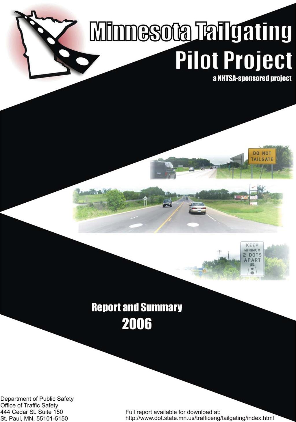
3 Project Summary In 2006, the Minnesota Departments of Transportation and Public Safety partnered with the Wright County Highway Department and the Safe Communities Coalition of Wright County to pilot a Tailgating Treatment Program similar to a Pennsylvania project honored with a 2001 National Highway Safety Award. The Minnesota project was viewed as a tool to educate motorists on how to identify and maintain a minimum safe following distance, and ultimately to reduce rear end crashes. The primary components of the project were: Roadway: A section of State Highway 55 in Wright County was used to paint 94 elliptical dots, spaced 225 feet apart, along a two-mile segment of the rural, single-lane, 55 mile-per-hour roadway. The dots were painted within a section of Highway 55 that was previously designated a Toward Zero Deaths corridor. The study corridor had an estimated average travel rate of 16,000 vehicles per day, no dedicated left turn lanes, minimal grade differences, and no congestion issues. In addition to the dots, a series of four different signs directing motorists to maintain at least two dots between them and the vehicle ahead were placed along the corridor. Following Distance: To maintain consistency with information currently provided through driver training and other safe driving programs, the project used the three-second minimum safe following distance strategy. Law Enforcement Activity: The project did not include an enhanced enforcement component. This provided an opportunity to evaluate the engineering and public information components in modifying driver behavior independent of an enhanced enforcement deterrent. Public Information Campaign: The public was informed of the project through the distribution of informational handouts at area businesses, local mailings, and a June 22 press event. The project received television, radio and print coverage throughout the state, as well as national coverage by the New York Times and other publications outside Minnesota. Evaluation Criteria: Vehicle headway data was collected for 48 hours prior to and after installation of the pavement marking dots and signs. Traffic counting tubes were set one-mile prior to the beginning of the marking location, at the mid-point of the marking location, and one-mile after the marking location, in both east and west bound lanes. The raw data was filtered to exclude vehicles following at sevenseconds or more, vehicles traveling under 45 mph, and vehicles with more than two axles. Outcome: The combination of all data collection points showed an increased average gap from 2.35 to 2.52 seconds, or 14.1 feet. The greatest average increase occurred at the mid-point location, where the average gap increased from 2.36 to 2.62 seconds, or 22.9 feet. The average gap increased from 2.49 to 2.64 seconds, or 12.9 feet at the points placed one-mile after the marking locations. When excluding the data from collection points set one-mile prior to the marking location, the overall average gap increased by 17.9 feet. This more accurately reflects the projects impact as behavioral changes should not be expected prior to the application site. Page 1
4 In addition to collecting headway data, the tubes also recorded speed data along the posted 55 mph corridor. Speeds at all points along the study corridor showed an overall average reduction from 58.6 to 57.9 mph, or -0.6 mph. Average speeds one-mile prior to the marking location decreased from 58.8 to 56.8 mph, or -2.0 mph. Average speeds decreased from 59.7 to 58.6 mph, or -1.1 mph at both points one-mile into the marking location, and at points one-mile after the marking locations the average speed increased from 56.9 to 58.4 mph, or +1.5 mph. (Speeds are rounded to one decimal point.) Funding and Costs: The Minnesota Department of Public Safety, Office of Traffic Safety (OTS) contracted with the Minnesota Department of Transportation Office of Traffic Security and Operations (MN/DOT) to provide labor, materials, printing and equipment needed to create a template, paint dots, fabricate signs, and to produce public information pieces. The OTS receives funding from the National Highway Traffic Safety Administration (NHTSA), under the State and Community Highway Safety Program (Public Law ) to address highway safety problems in Minnesota. The total cost expended on the project was $14, Additionally, numerous staff hours from Wright County, MN/DOT, and OTS were provided in-kind. Additional project details can be found in the following pages of this report. Page 2
5 The Tailgating Problem in Minnesota: In 2002 there were 22,206 rear-end crashes resulting in 21 deaths. Rear end crashes accounted for 23.3% of the total crashes and 3.1% of the total traffic fatalities in the state saw an increase in fatal rear-end crashes resulting in 28 fatal crashes killing 30 people. This accounted for 4.8% of the total fatal crashes and 4.5% of the total traffic fatalities in the state. 1 In 2004 rear end crashes increased to 25,621, accounting for 27.6% of the total crashes. Rear end crashes killed 19 people, representing 3.3% of the total traffic fatalities in the state in In comparison to 2004, rear end crashes dropped to 24,820 in 2005, yet remained higher than In 2005 rear end crashes represented a higher percentage of all crashes 28.2%, fatal crashes, 21, and fatalities, 22 when compared to 2004 statistics. Total fatal Rear-end Crashes Total Rearend Crash Fatalities Total Fatality % Year Total Rearend Crashes Total Crash % , % % 2003 Not available Not available % , % % , % % Total or Average 26.36% % Given the fact that the number of vehicles with anti-lock braking systems has increased each year, this relatively new technology is not causing any consistent downward trend in rear-end crashes. This indicates that the problem lies with driver behavior, not vehicle deficiency. Minnesota s Dot Tailgating Pilot Project: Given the successes, relatively low implementation cost, and the measurable benefits of a Pennsylvania dot program honored with a 2001 National Highway Safety Award, Minnesota piloted a similar project in The project was viewed primarily as a tool to help educate motorists on how to identify and maintain safe minimum following distances, with the hope that drivers will apply the same learned behavior on other roadways. Minnesota used similar engineering elements from the Pennsylvania program. Use of elliptical pavement dots, informational signs, and a strong public information campaign were the main elements used from the Pennsylvania project. The primary exceptions to the Pennsylvania project included the use of a rural single-lane 55 mile per hour roadway, a three-second safe following distance criteria, no additional law enforcement activity, and non-crash related evaluation criteria. Greater detail of each of these elements is explained later in this report Minnesota Motor Vehicle Crash Facts Page 3
6 Project Partners: Wright County Highway Department Safe Communities Coalition of Wright County Wright County Sheriff s Office Minnesota Department of Transportation Minnesota Department of Public Safety, Office of Traffic Safety Minnesota State Patrol National Highway Traffic Safety Administration Buffalo Police Department Contact information can be found at the end of this report. Timelines: October 2005: Project planning began. April 2006: FHWA approval to experiment granted. June 6 through June 8, 2006: 48 hours of pre-project weekday headway data collected. June 19: Signs placed and pavement marking dots painted. June 22: Kick-Off/Press Event held. July 25 through July 27, 2006: After-data collected in the same manner and same weekdays as the pre-project data. Public Information, Education and Media: The primary role of the Safe Communities Coalition of Wright County was to coordinate all public information, education and media efforts for the project. Executive Director Patricia Hackman was instrumental in the development and distribution of the public information piece, press releases, and coordination of the press conference announcing the project to the public. On June 22 a press conference was held at the Wright County Government Center in Buffalo, Minnesota. A press release from the Minnesota Department of Public Safety was coordinated with the media event. Project information was aired on all of the major metropolitan network television news programs: WCCO Channel 4, KSTP Channel 5, KMSP Fox 9, and KARE Channel 11. Radio interviews were aired on the following stations: Station Area Interviewed KTLK-FM Fox News Talk Twin Cities Dan Brannan, Mn/DOT WCCO-AM News Radio Twin Cities & statewide Pat Hackman, Wright Co. MNN Radio Network Statewide Pat Hackman, Wright Co. MN Public Radio Statewide Kathy Swanson, Director, Office of Traffic Safety KCLD-FM Top 40 Pop St. Cloud Pat Hackman, Wright Co. KNSI-AM News Radio St. Cloud Pat Hackman, Wright Co. Landline Now XM Trucker Radio Missouri/National Gordy Pehrson, Mn/DPS Page 4
7 Mn/DOT s Office of Traffic, Security and Operations created a Tailgating Project Web site; that featured public information and a list of frequently asked questions (FAQ s). The DPS Office of Traffic Safety (OTS), and the DPS Communications Office acted in an advisory capacity with public relations and information efforts. Print and web articles included: Minneapolis Star Tribune, June 23. Delano Eagle, June 26. Annandale Advocate, June 28. Wright County Journal Press, June 30. Officeroutlook.com, June, Stateline.org, July 7. Politicalgateway.com, July 7 The New York Times, July 21 The Urban Transportation Monitor, July 21. The Buffalo Allina Hospital s Healthy Communities Magazine featured the project in their Fall 2006 publication. The magazine is distributed to about 60,000 homes and businesses in the Wright County area. A sample of some print media pieces can be found at the end of this report. Main differences from the Pennsylvania project: Three-seconds was used as the safe following distance criteria as opposed to two-seconds used in the Pennsylvania study. A rural, single-lane, 55 mile per hour roadway was used for the study corridor. Additional law enforcement activity was not requested. Following distance measurements were used for evaluation criteria as opposed to crash statistics used in the Pennsylvania study. Three-second following distance: The two main causes of rear-end crashes are driver inattention and following too closely. 2 For several years, safe driving literature, text books, and driver educators used the two-second following distance strategy as the minimum safe following distance under ideal conditions. More recently this strategy was revised to three-seconds. 3 To support this strategy, three-seconds was used as the minimum safe following distance under ideal conditions for purposes of this pilot project. 2 Front end Analysis of Rear end Crashes, FHWA, May Alliance for Safe Driving, License to Drive, 2000, Page Page 5
8 Site Selection: A two-mile segment of east and west bound lanes of State Highway 55 in Wright County was selected using the following criteria: Rural driving environment. Single lane 55 mph corridor. Average Daily Traffic (ADT) rate of approximately 16,000 vehicles. Absence of multiple intersections, dedicated left turn lanes, significant grade differences, and traffic congestion. Presence of an active Safe Communities Coalition with a Toward Zero Deaths (TZD) Corridor The specific 2-mile section of State Highway 55, between County State Aid Highway 14 on the west and Deadrick Avenue to the east, was identified as the preferred site due to the 16,000 vehicle ADT, and the absence of multiple intersections, dedicated left turn lanes, significant grade differences, and traffic congestion. Two county roads intersect with the study corridor. The absence of multiple intersections within the study area assured that a significant majority of drivers were exposed to the entire treatment site. This provided a manageable control for the evaluation of the projects effectiveness in changing driver behavior. The decision to use a rural, single-lane, 55 mph corridor was made because this type of roadway was not included in the Pennsylvania study, and rural, single-lane, 55 mph roads are the most prevalent type of roadway in Minnesota. More than 50% of the fatal crashes in Minnesota occur on rural, single-lane, 55 mph roads. Therefore innovative, low-cost safety solutions have the greatest potential for success. Law Enforcement: Involvement with the Wright County Sheriff s Office, Buffalo Police Department, and the Minnesota State Patrol, played an important role in the project. Law enforcement was requested to help educate motorists through the distribution of an informational handout given to motorists during routine traffic stops and public meetings in the Wright County area. Officers were not asked to modify current enforcement activities along the corridor. The working group believes the exclusion of enhanced enforcement activities along the corridor during the pilot aided in obtaining a clearer evaluation of the project s effectiveness in modifying driver behavior. Pavement Dots: A total of 94 equally spaced elliptical dots (47 in each direction), spaced 225 feet apart, were painted in the center of east and west bound travel lanes by Traffic Marking Services Inc. using a template and latex paint. The dots provided motorists with a physical reference reinforcing safe following distances between vehicles. The dots were spaced 225 feet apart, so two dots were visible to motorists following others with three-seconds between them, when traveling at 55 miles per hour - the posted speed limit on the corridor. In accordance with MUTCD standards for oblong pavement markings, the width to height ratio is 1:3. (2.5 ft by 7.5 ft.) for each dot. The dots were considered experimental and went through the approval process by FHWA. Page 6
 Office of Transportation")


9 Signs: In accordance with the 2003 Manual on Uniform Traffic Control Devices (MUTCD), a formal request to experiment using signs that were not included in the MUTCD was submitted with the Federal Highway Administration (FHWA) Office of Transportation Operations. FHWA granted approval on April 6, Mn/DOT engineers designed the signs and determined their placement along the study corridor to maximize their effectiveness. The signs were posted for both east and west bound traffic and were limited to four specific messages: Posted prior to the treatment site. Posted within the treatment site. The symbol promoted conveyance of the basic message to motorists that may have difficulty reading the entire sign. Posted within the treatment site. Posted after the treatment site. Page 7
10 Evaluation Methodology: The use of rear-end crash data for project evaluation would require data to be collected over several years. Therefore, specific gap measurements were used as the primary evaluation criteria. This data collection method also provided speed measurement data. Therefore, speed measurements are included as a secondary project evaluation tool. Vehicle headway data was collected for 48 hours beginning Tuesday, June 6 through Thursday, June 8, 2006, prior to the installation of the signs and pavement marking dots. Traffic counting tubes were set for each direction of travel approximately one mile prior to the beginning of the pavement marking location, one mile into the planned markings, and one mile after the planned marking location. The pavement marking dots were painted June 19 th, 2006 and after data was collected in the same manner and same weekdays from July 25 through the 27. The data was collected with TimeMark s, Lambda counting machine with two tubes set in each location spaced 16 feet apart. Layout number 52 of the Lambda machine was used to format the data and export into an Excel database. The volume of raw data totaled 88,738 vehicles. The raw data was filtered to exclude vehicles following at seven-seconds or greater and vehicles with more than two axles. Additionally, vehicles traveling at abnormally low speeds, less than 45 miles per hour, were excluded from the data, as it was likely that they were farm implement or permitted special use vehicles. Outcomes: The combination of all data collection points showed an increased average gap from 2.35 to 2.52 seconds, or 14.1 feet. The greatest average increase occurred at the mid-point location, where the average gap increased from 2.36 to 2.62 seconds, or 22.9 feet. The average gap increased from 2.49 to 2.64 seconds, or 12.9 feet at the points placed one-mile after the marking locations. When excluding data from collection points set one-mile prior to the marking location the overall average gap increased by 17.9 feet. This more accurately reflects the projects impact as behavioral changes should not be expected prior to the application site. In addition to collecting headway data, the tubes also recorded speed data along the posted 55 mph corridor. Speeds at all points along the study corridor showed an overall average reduction from 58.6 to 57.9 mph, or -0.6 mph. Average speeds one-mile prior to the marking location decreased from 58.8 to 56.8 mph, or -2.0 mph. Average speeds decreased from 59.7 to 58.6 mph, or -1.1 mph at both points one-mile into the marking location, and at points one-mile after the marking locations the average speed increased from 56.9 to 58.4 mph, or +1.5 mph. (Speeds are rounded to one decimal point.) Page 8
11 Outcome Data Data Collection Points; east and west bound lanes: Site A: Approximately one-mile prior to the beginning of the marking location. Site B: Mid-point of the dots marking location. Site C: One-mile after the marking location, in both east and west bound lanes. AVERAGE AVERAGE AVERAGE AVERAGE COLLECTION GAP GAP INCREASE SPEED GAP INCREASE POINTS (Seconds) (Seconds) (MPH) (Feet) All: Before 2.35 After All East: Before 2.33 After All West: Before 2.36 After Site A Before 2.22 East & West: After Site B Before 2.36 East & West: After Site C Before 2.49 East & West: After Page 9
12 All Collection Sites N= Sample Volume P= Probability of change Pre-Project During Project Change P N 56,648 55,922 Gap <.0001 Speed <.0001 All East Bound Collection Sites Pre-Project During Project Change P N 26,498 25,989 Gap <.0001 Speed <.0001 All West Bound Collection Sites Pre-Project During Project Change P N 30,150 29,933 Gap <.0001 Speed <.0001 East and West (Site A) Pre-Project During Project Change P N 19,050 18,535 Gap <.0001 Speed <.0001 East and West Mid-Point (Site B) Pre-Project During Project Change P N 20,885 20,213 Gap <.0001 Speed <.0001 East and West Mid-Point (SiteC) Pre-Project During Project Change P N 16,713 17,174 Gap <.0001 Speed <.0001 Page 10
13 Funding and Costs: The Minnesota Department of Public Safety, Office of Traffic Safety (OTS) initially set aside $25,000 for a contract with the Minnesota Department of Transportation Office of Traffic Security and Operations (MN/DOT) to provide labor, materials, printing and equipment needed to create a template, paint dots, fabricate signs, and to produce public information pieces. The OTS funding is apportioned by the National Highway Traffic Safety Administration (NHTSA), under the State and Community Highway Safety Program (Public Law ) to address highway safety problems in Minnesota. The total cost for the project was $14, Additionally, numerous staff hours from Wright County, MN/DOT, and OTS were provided in-kind. Test Location Restoration, Abatement, or Expansion Considerations: In the spring of 2007, Mn/DOT officials will consider restoration or abatement of the existing dots and signs along the study corridor and explore the feasibility of expanding the project to roadways in other parts of the state. Restoration would require repainting each of the 94 dots and could include a reevaluation component. Abatement would require the removal of eight signs and painting over the remnants of the 94 dot markings. Lessons Learned: In July, 2006 the Minnesota Motorcycle Safety Advisory Committee (MMSAC) expressed concern over potential traction issues for motorcyclists traversing the painted dots. This issue was discussed by the planning committee at the beginning of the project planning process. It was agreed that motorcycle traction issues were not a concern as the pilot roadway did not include sharp turns and the size and placement of the dots provided motorcyclists adequate space to safely ride on either side of the dots. If the decision is made to expand the project beyond the pilot corridor the OTS Coordinator agreed that the MMSAC should be consulted, and if their safety concerns are justifiable, alternative paint designs could be explored. As a result of the Wright County Tailgating project, Senator Amy Koch expressed interest in updating MN laws that address tailgating. She had senate researchers review legislation throughout the country. The researchers found specific wording that may make it easier for officers to cite tailgating behavior if added to Minnesota laws. Senator Koch is working on this issue with Buffalo Police Chief Mitch Weinzetl. It is possible that Senator Koch will submit a proposal to the upcoming legislative session. Page 11
14 Contact Information: Patricia Hackman, Executive Director Safe Communities of Wright County P.O. Box 335 St. Michael, MN (763) Wayne Fingalson, Wright County Engineer 1901 Highway 25 North Buffalo, MN (763) Dan Brannan, Traffic Safety Specialist Minnesota Department of Transportation, Office of Transportation Security and Operations 1500 West County Road B2, MN 725 Roseville, MN (651) Tom Dumont, Traffic Engineer Minnesota Department of Transportation, District th Street North St. Cloud, MN (320) Thomas.Dumont@dot.state.mn.us Dave Engstrom, State Traffic Safety Engineer Minnesota Department of Transportation, Office of Transportation Security and Operations 1500 West County Road B2, Roseville, MN (651) Gordy Pehrson, Traffic Safety Coordinator Minnesota Department of Public Safety, Office of Traffic Safety 444 Cedar Street, Suite 150 St. Paul, MN (651) gordy.pehrson@state.mn.us Page 12
15 Media Sample #1: Sun Newspapers, January 17, 2006; By John Holler Wright County to try experimental program to stop roadway tailgating; Project to focus on Hwy. 55 between Buffalo and Rockford With the growth of Wright County, the roadways used to get people from one place to another whether a commute to work or a quick run to the grocery store have become much more congested. As a result, there has been more tailgating, as people in a hurry still look for the chance to get from Point A to Point B as quickly as possible. At the Tuesday, Jan. 10, meeting of the Wright County Board, the commissioners were informed of a pilot project that will combine information and enforcement in order to prevent accidents by keeping tailgating to a minimum. Wright County Highway Engineer Wayne Fingalson told the board of a project from the Minnesota Department of Public Safety that is designed to teach about tailgating as well as prevent it. We ve been given a $25,000 grant from the state to implement the program on Hwy. 55 between Buffalo and Rockford, Fingalson said. It keeps with the theories that have been taught about tailgating whether it s the 3-second rule in between cars or the one car length for every 10 miles an hour rule. Under this system, a series of dots will be painted on the road and drivers will have a visual to see how close is too close. The project, which began with a pilot program in Pennsylvania, will have signage explaining that drivers must remain two of the road-painted dots behind the vehicle in front of them. In the Pennsylvania study, it was determined that crashes were reduced by 55% on the roads in which the system was implemented and it is hoped that Hwy. 55, which is a heavily congested and welltraveled roadway, will do the same. But Fingalson said enforcement will be the key. The state patrol is run by the Department of Public Safety, so additional enforcement will be provided, Fingalson said. The intent isn t to give out more tickets, but to remind drivers how dangerous tailgating can be. The project is expected to be undertaken in June. This site and its contents Copyright Sun Newspapers - Main Office: webinfo@mnsun.com - Page 13


16 Media Sample #2: Stateline.org, July 7, 2006; By John Gramlich Friday, July 07, 2006 State DOTs hope drivers see dots By John Gramlich, Special to Stateline.org For drivers who get anxious when cars grow bigger and bigger in their rear-view mirrors, cheap and easy help may be on the way oval-shaped dots painted on the highway or hot-pink panels along the side of the road. Test programs in Maryland, Minnesota and Pennsylvania aim to curb tailgating by using road markers that alert motorists to distances between vehicles. The markers serve as a tangible reminder of commonly taught driving guidelines such as the two-second rule, which urges drivers to stay at least two seconds behind the car ahead. Unlike the two-second rule, however, the road markers provide motorists with accurate, measured following distances. The Minnesota Department of Transportation announced June 22 that a two-mile stretch of state Highway 55 about 40 miles northwest of Minneapolis has been painted with 94 white, oval-shaped distance dots. Spaced 225 feet apart in a zone with a 55-mph speed limit, the dots are accompanied by signs reading Keep Minimum 2 Dots Apart and 2 Dots = 3 Seconds the latter being true if motorists stick to the speed limit. Image courtesy of Minnesota Department of Transportation Along Minnesota s state Highway 55, two dots equal three seconds of following time at 55 mph. Minnesota recently began recommending three seconds between cars, though it has recommended two seconds in the past, said Gordy Pehrson of the Department of Public Safety, which has worked with the transportation department on the project. Partially due to the aging population and faster, heavier traffic, three seconds is the best way to go, Pehrson said. Image courtesy of Maryland Transportation Authority Motorists heading east on the Chesapeake Bay Bridge will notice this sign beginning in July. In Maryland, the state s Transportation Authority announced May 19 that an eastbound section of the Chesapeake Bay Bridge, about 40 miles east of Washington, D.C., would use technology similar to Minnesota s distance dots. But its plan, called Keep Your Cool and Pace Your Space, will exchange the dots for hot-pink panels along the side of the road. The Pace Your Space program will use panels because they can be mounted at drivers eye level and are easier to maintain than dots on the road, according to transportation spokeswoman Teri Moss. The panels were to be installed starting July 10, she said. Accidents are the main cause of congestion on the Chesapeake Bay Bridge, a popular gateway to Maryland s Atlantic coast, especially during summer. Rear-end collisions accounted for 58 percent of
17 crashes on the bridge between 2002 and 2004, with 70 percent occurring in eastbound lanes, Moss said. The Maryland and Minnesota programs owe allegiance to Pennsylvania, which first used antitailgating road markers in 2000 on a rural stretch of U.S. Route 11 near the town of Bloomsburg, about 100 miles northwest of Philadelphia with eye-opening results. Like Minnesota s project, the Pennsylvania test site used white dots painted on a two-lane road. Pennsylvania, however, still recommends the two-second rule, and the dots on Route 11 are spaced 115 feet apart or two seconds, if motorists follow the road s 45-mph speed limit. The program resulted in a 65-percent drop in accidents from November 2000 to March 2001 compared with the previous year, according to the Pennsylvania Department of Transportation. That earned the program a National Highway Safety Award in 2001 from the Federal Highway Administration (FHA). In 2003, the FHA separately listed the program as a Low-Cost Traffic Engineering Improvement that other states could replicate. Officials in Maryland and Minnesota developed their programs based on Pennsylvania s success. According to the FHA s 2003 listing of the Pennsylvania program, installing one test site costs $1,892, including equipment, signs and labor. The recently unveiled site in Minnesota used a $25,000 federal grant to pay for the installation and a public information campaign. Maryland has not disclosed the cost of its Chesapeake Bay Bridge plan. Since its initial success in 2000, Pennsylvania has experimented with the dots on a handful of other sites, including on Interstates 80 and 81, according to Steve Chizmar, a state transportation spokesman. But success has been greater on two-lane roads than on interstates and depends heavily on police enforcement of proper following distance, Chizmar said. South Centre Township, Pa., police, who monitor the test site on Route 11, have issued about 15 citations a month for aggressive driving since the dots arrived, according to Chief of Police William Richendrfer. It comes down to enforcement, Chizmar said. You have these hard-nosed, aggressive drivers who feel they re above the law. They re going to ignore warnings. Unlike Pennsylvania, Maryland and Minnesota will begin their test programs without specifically instructing police to enforce safe following distances. Instead, Minnesota transportation officials will monitor compliance on Highway 55 to determine whether the dots and signs are effective on their own, according to Pehrson. Send your comments on this story to letters@stateline.org. Selected reader feedback will be posted in the Letters to the editor section. Contact John Gramlich at jgramlich@stateline.org. Page 15
18 Media Sample #3: New York Times, July 21, 2006: By Gretchen Ruethling Minnesota Has a Warning for Tailgaters, Every 225 Feet BUFFALO, Minn. Even after a collision five years ago resulted in surgery and left her with limited mobility in her neck, Missy Weberg said she continued the dangerous habit that caused the accident: tailgating. But a new Minnesota initiative using big white dots painted on a state highway is helping Ms. Weberg back away from cars in front of her, she said. The dots, 94 of them painted on a two-mile stretch of a rural highway about 35 miles northwest of Minneapolis, were unveiled last month in a pilot project that officials hope will teach drivers about safe following distances. If they had more dots, I d probably tailgate a lot less, Ms. Weberg, 36, said. I m guessing it will save a lot of accidents and lives. Maryland started a similar project this month on the eastbound span of the Chesapeake Bay Bridge in Annapolis using hot pink panels. Pennsylvania began experimenting with distance dots in 2000, but stopped adding them to roads in 2003 because transportation officials said they were not deterring the worst offenders. Although many drivers might see tailgating as nothing more than an annoyance, it is a significant factor in many accidents, safety officials said. In Minnesota, rear-end collisions accounted for 28 percent of all crashes last year and resulted in 22 deaths, according to the State Office of Traffic Safety. And the number of rear-end crashes in the state increased to 24,820 last year, from 22,206 in It s truly dangerous, said Pat Hackman, executive director of Safe Communities of Wright County, a nonprofit traffic safety organization. And some people might say, Don t we have bigger problems than this? And we certainly do. But I don t think you quite understand how this is contributing to the bigger problems that we have. The idea of the dots on the highway here, explained on roadside signs, is for drivers to keep a distance of two dots between vehicles. The 225 feet between dots represents a driving interval of three seconds at the speed limit of 55 miles per hour. Gordy Pehrson, traffic safety coordinator in the Office of Traffic Safety, said he hoped the dots would have a halo effect, with drivers taking the lesson to other roads as well. This is not intended to be the cure-all for all the tailgating problems, Mr. Pehrson said. Obviously we re not going to paint dots on every road in the state. Some area residents said they thought that few drivers would pay attention to the dots without more police enforcement and complained that the $25,000 federal grant to start the program was a waste of money. Luke Zumbusch, 18, of Buffalo, said he thought some drivers would ignore the dots. Mr. Zumbusch said he would continue trailing as close as a half car length behind slow drivers to try to push them to go faster. I think they mean good by it, he said of transportation officials, but it s just going to be pointless. State officials chose the stretch of road here that cuts through farms and rolling fields because it has an accident rate that is higher than average. Almost 80 percent of crashes at intersections on the highway are rear-end collisions, officials said. They recorded speed and following distances before the project began and will continue to do so in its threemonth run to measure the effect of the dots, which make the black paved road resemble a long domino. Mr. Pehrson said state officials were encouraged by the early success in Pennsylvania. The Pennsylvania project won a National Highway Safety Award in 2001 after a study found that tailgating dropped 60 percent on one dotted stretch of highway. But a Pennsylvania Department of Transportation spokesman, Rich Kirkpatrick, said the state discontinued the program after a longer-term study showed that although safe drivers increased their following distance, the dots had little effect on aggressive drivers. They seemed to just ignore the dots and the safety signs, Mr. Kirkpatrick said. Some drivers here, though, remain enthusiastic about the Minnesota experiment. Matt Graunke, 28, of Buffalo, said people might not realize the difference the dots were making. I find myself, when I m on that section of road, counting them whether I like it or not, Mr. Graunke said. If it s going to keep one person from getting killed, it sounds fine to me. Riding in the car has become a lot more fun for Lauren Stenlund s 4-year-old daughter, Taylor, who loves counting the dots and catching her mother when she is not keeping a proper distance. We try to turn it into a game, said Ms. Stenlund, 25, of Greenfield. It s kind of fun for kids because they can tell you if you re doing it right or wrong. And as for Ms. Weberg, who had trouble changing her habits, the dots are a reminder to stay vigilant. I m just an impatient driver, she said. Page 16

19 Media Sample #4: Allina s Healthy Communities Magazine, Fall, 2006 Minding your DOTS NEARLY 80 PERCENT of crashes at Highway 55 intersections in Wright County are rear-end collisions, typically caused by driver inattention or by following vehicles too closely. To reduce crashes caused by motorists following too closely, a series of large dots have been painted along Highway 55 just east of Buffalo along with signs directing drivers to keep at least two dots between them and the car ahead. The dots are designed to educate motorists on how to identify and maintain a safe minimum following distance, says Wayne Fingalson, Wright County Highway engineer. A similar effort was used in Pennsylvania, combined with law enforcement, and crashes dropped 55 percent one year after implementation. Tailgating is one of the most common poor-driving habits, says Pat Hackman, executive director of Safe Communities of Wright County. While the impact of the DOTS project won t be known for several months, we know we re educating drivers about what a safe following distance is and hope they ll apply this to their driving habits on all roads. Maintaining a proper following distance is more than just being a polite driver, it s the law. The DOTS pilot project is part of the Toward Zero Deaths initiative, sponsored by Safe Communities of Wright County, the Minnesota Departments of Public Safety and Transportation, Wright County Highway Department and you. Buffalo Hospital is one of the founding partners of Safe Communities. Visit or call for more information. Easy as 1-2-3s Follow the three-second rule. When the back end of a vehicle ahead passes a stationary object, such as a sign along the road, count how long it takes to pass the same object: one Minnesota, two Minnesota, three Minnesota. BE SAFE BACK OFF Two dots could mean the difference between life and death. Page 17
FEDERAL HIGHWAY ADMINISTRATION APPLICATION
 FEDERAL HIGHWAY ADMINISTRATION APPLICATION REQUEST FOR PERMISSION TO EXPERIMENT WITH A BICYCLE BOX INTERSECTION TREATMENT Submitted by: City of Columbus Department of Public Service Date: June 26, 2009
Pavement Markings (1 of 3)
") Pavement Markings (1 of 3) DESCRIPTION AND DEFINITION Disadvantages Relatively high cost (over typical Crash reduction as yet unknown painted edge line) No tactile effect The STOP AHEAD pavement marking
Pavement Markings (1 of 3) DESCRIPTION AND DEFINITION Disadvantages Relatively high cost (over typical Crash reduction as yet unknown painted edge line) No tactile effect The STOP AHEAD pavement marking
DEPARTMENT OF ENVIRONMENTAL SERVICES. North Harrison Street (Lee Highway to Little Falls Road) Comparative Analysis. Prepared for:
 Comparative Analysis. Prepared for:") DEPARTMENT OF ENVIRONMENTAL SERVICES North Harrison Street (Lee Highway to Little Falls Road) Comparative Analysis Prepared for: Arlington County Department of Environmental Services 2100 Clarendon Boulevard,
DEPARTMENT OF ENVIRONMENTAL SERVICES North Harrison Street (Lee Highway to Little Falls Road) Comparative Analysis Prepared for: Arlington County Department of Environmental Services 2100 Clarendon Boulevard,
Crosswalk event overview (Saint Paul) How to organize a crosswalk event. 1. Choose a date, time and location
 How to organize a crosswalk event. 1. Choose a date, time and location") Crosswalk event overview (Saint Paul) A crosswalk event occurs when an individual or group of individuals promote pedestrian safety by demonstrating the proper use of a crosswalk. During the event, a group
Crosswalk event overview (Saint Paul) A crosswalk event occurs when an individual or group of individuals promote pedestrian safety by demonstrating the proper use of a crosswalk. During the event, a group
Safety Corridors a Synthesis. Charlie Nemmers / Derek Vap University of Missouri
 Safety Corridors a Synthesis Charlie Nemmers / Derek Vap University of Missouri 1 Background: Safety Corridors Study Need grew from a four State Safety Summit Funding from Iowa, Kansas, Missouri DOTs and
BIKE PLAN CONTENTS GATEWAY
 CONTENTS Acknowledgments...vii Great Rivers Greenway District Board of Directors... vii Great Rivers Greenway District Staff... vii Project Consultants... vii Committees... viii Citizens Advisory Committee
SLOW DOWN A STUDY OF SPEEDING ON MCGUINNESS BLVD
 SLOW DOWN A STUDY OF SPEEDING ON MCGUINNESS BLVD ACKNOWLEDGEMENTS This report was prepared by Shawn Macias, in consultation with the McGuinness Boulevard Working Group. This report would not have been
Work Zone Traffic Safety
 Work Zone Traffic Safety Summary The Hazard: death or serious injury from being struck by vehicles or equipment in work zones. Who is at risk: streets/highways, utilities and other public works department
CROSSING GUARD PLACEMENT CONSIDERATIONS AND GAP ASSESSMENT
 CROSSING GUARD PLACEMENT CONSIDERATIONS AND GAP ASSESSMENT Many factors contribute to the need for a Crossing Guard. General federal guidance, provided by the FHWA MUTCD, states that adult crossing guards
Table of Contents. I. Introduction 1. II. Elements of the School Crossing Program 1
 Table of Contents Page I. Introduction 1 II. Elements of the School Crossing Program 1 a. Identifying Locations Where School Crossing Guards are Needed 1 b. The Role of the School Crossing Guard 1 c. Hiring
Review of Considerations and Requirements for Automated Enforcement
 Review of Considerations and Requirements for Automated Enforcement Summary: The purpose of this report is to provide information related to expanding the use of automated enforcement in the City of Toronto,
WEST AVENUE AND NEW ROAD TRAFFIC STUDY PART III WEST AVENUE CLOSURE ALTERNATIVES ANALYSIS
 WEST AVENUE AND NEW ROAD TRAFFIC STUDY PART III WEST AVENUE CLOSURE ALTERNATIVES ANALYSIS CITY OF LINWOOD ATLANTIC COUNTY, NEW JERSEY March 30, 2006 PREPARED FOR: City of Linwood 400 Poplar Avenue Linwood,
road safety issues 2001 road toll for Gisborne district July 2002 Road user casualties Estimated social cost of crashes*
 GISBORNE DISTRICT road safety issues July 22 The Land Transport Safety Authority (LTSA) has prepared this Road Safety Issues Report. It is based on reported crash data and trends for the 1997 21 period.
TOOLKIT STOP ON RED. National. Week August 6-12, 2017 RED-LIGHT RUNNING FACT. #StopOnRed2017 to spread the message!
 National STOP ON RED Week August 6-12, 2017 RED-LIGHT RUNNING FACT In 2015, 771 people were killed due to red-light running and an estimated 137,000 were injured. Source: IIHS TOOLKIT Learn more about
Pedestrians safety. ROAD SAFETY SEMINAR PIARC/AGEPAR/GRSP Lome, Togo October 2006 Lise Fournier, Canada-Qu
 Pedestrians safety ROAD SAFETY SEMINAR Lome, Togo October 2006 Lise Fournier, Canada-Qu Québec Contents WHO s data Risk factors Pedestrian needs Pedestrian facilities Conclusion Source: WHO WHO reports
Purdue Road Show IN-TIME Executive Session March 8, 2016
 Purdue Road Show IN-TIME Executive Session March 8, 2016 Sources of Congestion Traffic Congestion and Reliability. FHWA (September 2005) Traffic Congestion and Reliability. FHWA (September 2005) 2 Secondary
Methods to Reduce Traffic Speed in High Pedestrian Areas. Revised Work Plan
 Methods to Reduce Traffic Speed in High Pedestrian Areas Revised Work Plan Principal Investigators Ali Kamyab Gary Thomas Center for Transportation Research and Education (CTRE) 2901 South Loop Drive,
Bureau of Planning and Research. Project No.: (C14) Phase II Final Report March 2, 2007 CMA
 Phase II Final Report March 2, 2007 CMA") Bureau of Planning and Research Safer Driver Actions at Stop Signs Project No.: 04-01 (C14) Phase II Final Report March 2, 2007 CMA Technical Report Documentation Page 1. Report No. 2. Government Accession
Bureau of Planning and Research Safer Driver Actions at Stop Signs Project No.: 04-01 (C14) Phase II Final Report March 2, 2007 CMA Technical Report Documentation Page 1. Report No. 2. Government Accession
CITY OF WEST LAKE HILLS. Forest View Neighborhood Traffic Calming Study
 CITY OF WEST LAKE HILLS 901 South Mopac Expressway Building V, Suite 220 Austin, Texas 78746 Texas P.E. Firm Registration No. F-929 Klotz Associates Final Report Submittal: March 20, 2015 Revised Final
Closing Plenary Session
 TRAFFIC SAFETY CONFERENCE Closing Plenary Session June 9, 2017 Las Colinas, TX Order of Report Out June 9, 2017 Las Colinas, TX Distracted Driving Prioritized Countermeasures Countermeasure 4a Systemically
Analysis of the Red Light Camera Program in Garden Grove, CA By Jay Beeber, Executive Director, Safer Streets L.A., Member ITE
 Analysis of the Red Light Camera Program in Garden Grove, CA By Jay Beeber, Executive Director, Safer Streets L.A., Member ITE The following report is a detailed discussion of the Red Light Camera (RLC)
Toward Zero Deaths. Regional SHSP Road Show Meeting. Virginia Strategic Highway Safety Plan. presented by
 Toward Zero Deaths Regional SHSP Road Show Meeting presented by Virginia Strategic Highway Safety Plan December 1, 2016 1 Welcome & Introductions Purpose of the Meeting Objectives & Key Outcomes Agenda»
Strategies. How to Develop a Pedestrian Safety Action Plan Enforcement 6-1
 How to Develop a Pedestrian Safety Action Plan Enforcement Strategies 6-1 Learning Objectives At the end of this module, you should be able to: Describe WHAT and HOW to integrate enforcement strategies
Lessons Learned from the Minnesota County Road Safety Plans. Richard Storm CH2M HILL
 Lessons Learned from the Minnesota County Road Safety Plans Richard Storm CH2M HILL May 21, 2014 Overview of the MN CRSP: Why Prepare Safety Plans for Local Systems? MAP-21: Requires states to address
Appendix C. Bicycle Route Signage
 Appendix C Bicycle Route Signage This page intentionally left blank. APPENDIX C - BICYCLE ROUTE AND WAYFINDING SIGNAGE Bicycle route signs are wayfinding signs that guide bicyclists along preferred, designated
Designing for Pedestrian Safety in Washington, DC
 Designing for Pedestrian Safety in Washington, DC February 25, 2014 George Branyan Pedestrian Program Coordinator District Department of Transportation DC Journey to work mode split: 2012 Means of Transportation
November 2, Government takes on the challenge of improving traffic safety
 November 2, 2006 Government takes on the challenge of improving traffic safety Edmonton... The Alberta government has taken on the challenge of improving traffic safety by moving ahead with a comprehensive,
Occ c u c pa p n a t pro r t O ec e t c i t O i n
 Occupant Protection Occupant Protection Introduction Buckling up or being buckled in is the most effective protection during a car crash. The simple truth is that the great majority of people ejected from
TRANSPORTATION ANALYSIS REPORT US Route 6 Huron, Erie County, Ohio
 TRANSPORTATION ANALYSIS REPORT US Route 6 Huron, Erie County, Ohio December 12, 2012 Prepared for: The City of Huron 417 Main Huron, OH 44839 Providing Practical Experience Technical Excellence and Client
How would you like it if people drove their cars thru your office?
 How would you like it if people drove their cars thru your office? Work Zone Safety More than 40,000 people are injured each year as a result of motor vehicle crashes in work zones How serious is the WZ
REGIONAL BICYCLE AND PEDESTRIAN DESIGN GUIDELINES
 REGIONAL BICYCLE AND PEDESTRIAN DESIGN GUIDELINES November 16, 2011 Deb Humphreys North Central Texas Council of Governments Bicycle and Pedestrian Advisory Committee Snapshot of the Guide 1. Introduction
Intersection Traffic Control Feasibility Study
 Intersection Traffic Control Feasibility Study CSAH 9 at CSAH 60 (185th Avenue) Prepared For: Dakota County Transportation Department Western Service Center 14955 Galaxie Avenue, 3rd Floor Apple Valley,
Traffic Calming Policy
 Article I. Purpose and Goal. The purpose of this policy is to establish criteria and procedures the City will use to evaluate requests for, and if appropriate, implement traffic calming measures. Neighborhood
City of Edmonton Office of Traffic Safety
 Overview About OTS Vision 0 Key Facts Speed Management Committee and Speed Management Plan Evidence on Speed and Speeding Complaint Process Data Collection Speed Surveys Collision Review Speed Management
Napier City road trauma for Napier City. Road casualties Estimated social cost of crashes* Major road safety issues.
 ISSN 1176-841X July 25 Land Transport New Zealand has prepared this road safety issues report. It is based on reported crash data and trends for the 2 24 period. The intent of the report is to highlight
Town of Mooresville, North Carolina Neighborhood Traffic Calming and Control Device Policy
 Town of Mooresville, North Carolina Neighborhood Traffic Calming and Control Device Policy Adopted January 6, 2014 Town of Mooresville Development Services Department TOWN OF MOORESVILLE NEIGHBORHOOD TRAFFIC
Agenda. Overview PRINCE GEORGE S PLAZA METRO AREA PEDESTRIAN PLAN
 PRINCE GEORGE S PLAZA METRO AREA PEDESTRIAN PLAN May 28, 2008 Agenda Welcome and introductions Project overview and issue identification Planning context and strengths Design challenges and initial recommendations
Characteristics of Traffic Accidents in Highway Work Zones
 Characteristics of Traffic Accidents in Highway Work Zones A DETAILED ANALYSIS OF WORK ZONE ACCIDENTS REPORTED ON NEW YORK STATE DEPARTMENT OF TRANSPORTATION CONSTRUCTION PROJECTS ESTABLISHED THE PREDOMINANT
The DC Pedestrian Master Plan
 The DC Pedestrian Master Plan September 28, 2010 George Branyan Pedestrian Program Coordinator District Department of Transportation Presentation Agenda Scope of the Plan Methodology Recommendations Implementation
Kentucky s Surface Transportation System
 Kentucky s Surface Transportation System ROAD AND BRIDGE CONDITIONS, TRAFFIC SAFETY, TRAVEL TRENDS, AND NEEDS MARCH 2018 PREPARED BY WWW.TRIPNET.ORG Founded in 1971, TRIP of Washington, DC, is a nonprofit
Public Information Centre
 WELCOME Public Information Centre Father Tobin Road Lougheed Middle School - Library Wednesday November 7, 2012 7:00 p.m.to 9:00 p.m. Please sign in Neighbourhood Traffic Calming Guide Background The City
Why Zone In on Speed Reduction?
 Learn it. Do it. Live it! SPEED REDUCTION IN THE ZONE Why Zone In on Speed Reduction? Speeding is a serious issue that plays a major role in the risk of serious injury and pedestrian fatality in a crash.
By: Bill Baranowski, PE TRAFFIC CALMING EXAMPLES IN SUGARHOUSE, DAYBREAK, AND WEST JORDAN CITY
 By: Bill Baranowski, PE TRAFFIC CALMING EXAMPLES IN SUGARHOUSE, DAYBREAK, AND WEST JORDAN CITY 1977 HIGHLAND RUGBY TOUR 1945 WHERE??? What is more contentious than traffic calming? 1951 LOOKING SOUTHEAST
City of Wayzata Comprehensive Plan 2030 Transportation Chapter: Appendix A
 A1. Functional Classification Table A-1 illustrates the Metropolitan Council s detailed criteria established for the functional classification of roadways within the Twin Cities Metropolitan Area. Table
2016 Annual Report. Work Zone Traffic Control. Bureau of Maintenance and Operations Highway Safety and Traffic Operations Division
 2016 Annual Report Work Zone Traffic Control Bureau of Maintenance and Operations Highway Safety and Traffic Operations Division Table of Contents Introduction... 3 Executive Summary... 4 Work Zone QA
133 rd Street and 132 nd /Hemlock Street 132 nd Street and Foster Street MINI ROUNDABOUTS. Overland Park, Kansas
 133 rd Street and 132 nd /Hemlock Street 132 nd Street and Foster Street MINI ROUNDABOUTS Overland Park, Kansas September 1, 2017 TABLE OF CONTENTS 1. INTRODUCTION... 1 2. LITERATURE REVIEW... 1 3. CONCEPT
TRAFFIC STUDY. Birch Bluff Road / Pleasant Avenue 01/15/2018. City of Tonka Bay 4901 Manitou Road Tonka Bay, MN WSB PROJECT NO.
 TRAFFIC STUDY Birch Bluff Road / Pleasant Avenue 01/15/2018 City of Tonka Bay 4901 Manitou Road Tonka Bay, MN 55331 WSB PROJECT NO. 10805-000 Birch Bluff Road/ Pleasant Avenue Traffic Study For: City of
A Residential Guide to Neighborhood Speed Enforcement
 A Residential Guide to Neighborhood Speed Enforcement City of Delaware, Ohio A Residential Guide to Neighborhood Speed Enforcement Introduction: The perception of speeding on local streets is probably
Creating a Successful Pedestrian Safety Campaign. St. Paul, MN
 Creating a Successful Pedestrian Safety Campaign St. Paul, MN - 2015-2017 The Problem The Problem A pedestrian or bicyclist is struck by a vehicle every other day in St. Paul (.84 per day) This doesn t
CHAPTER 1 STANDARD PRACTICES
 CHAPTER 1 STANDARD PRACTICES OBJECTIVES 1) Functions and Limitations 2) Standardization of Application 3) Materials 4) Colors 5) Widths and Patterns of Longitudinal Pavement Marking Lines 6) General Principles
THE EFFECTIVENESS OF LOW-COST TRAFFIC CALMING APPLICATIONS APPROPRIATE FOR MAIN STREETS THROUGH RURAL COMMUNITIES
 THE EFFECTIVENESS OF LOW-COST TRAFFIC CALMING APPLICATIONS APPROPRIATE FOR MAIN STREETS THROUGH RURAL COMMUNITIES Eric R. Petersen Civil Engineering (M.S.) Student Iowa State University (515) 223-6534
City of Edmonton Office of Traffic Safety
 Overview About OTS About OTS Key Facts Speed Management Committee and Speed Management Plan Evidence on Speed and Speeding Complaint Process Data Collection Speed Surveys Collision Review Speed Management
Abstract. Background. protected/permissive operation. Source: Google Streetview, Fairview/Orchard intersection
 ITE 2015 Western District Annual Meeting Ada County Highway District s Flashing Yellow Arrow Initiative Primary Author: Tim Curns, PE Ada County Highway District Traffic Engineer Author: Andrew Cibor,
Toward Zero Deaths: Proactive Steps for Your Community
 Est. Dec. 2014 Toward Zero Deaths: Proactive Steps for Your Community Presented by: Brian Roberts, P.E., National Association of County Engineers Marie Walsh, Ph.D., Louisiana Local Technical Assistance
Beaverton Police Department Traffic Safety Team
 Traffic Safety Team November 1, 2010 Executive Summary The Beaverton Police Department takes pride in the distinction as being one of the safest cities in the northwest. Being a safe city is more than
Proposed changes to Massachusetts MUTCD Supplement
 Proposed changes to Massachusetts MUTCD Supplement John F. Carr National Motorists Association October 24, 2002 This document contains recommendations as to the contents of the Massachusetts MUTCD supplement
WORKING LESSON PLAN School Bus Driver In-Service
 WORKING LESSON PLAN 2005-2006 School Bus Driver In-Service TITLE OF LESSON Blind Spots at Intersections and Crosswalks OBJECTIVE At the conclusion of this lesson, the students will be able to: Describe
General Design Factors
 Chapter 3: 3-1.0 Introduction General Design Factors Mn/DOT s goals include encouraging and accommodating safe bicycling. From a design perspective, these goals are achieved by first having an understanding
Sponsored by the Office of Traffic and Safety of the Iowa Department of Transportation NOVEMBER 2001 CTRE
 PAVED SHOULDERS ON PRIMARY HIGHWAYS IN IOWA: AN ANALYSIS OF SHOULDER SURFACING CRITERIA, COSTS, AND BENEFITS EXECUTIVE SUMMARY Sponsored by the Office of Traffic and Safety of the Iowa Department of Transportation
Traffic Impact Analysis Walton Acres at Riverwood Athletic Club Clayton, NC
 Traffic Impact Analysis Walton Acres at Riverwood Athletic Club Clayton, NC 1. TABLE OF CONTENTS INTRODUCTION...1 1.1. Site Location and Study Area...1 1.2. Proposed Land Use and Site Access...2 1.3.
NYC Pedestrian Safety Study & Action Plan. NYTMC Brown Bag Lunch Presentation December 15, 2010
 NYC Pedestrian Safety Study & Action Plan NYTMC Brown Bag Lunch Presentation December 15, 2010 1 Introduction DOT Safety Goal Strategic Plan: Reduce Fatalities by 50% by 2030 From 274 (2007) to 137 (2030)
Highway 12 Safety Coalition
 Highway 12 Safety Coalition City of Wayzata, City of Long Lake, City of Orono, City of Medina, City of Maple Plain, City of Independence, City of Delano, City of Montrose, City of Waverly, City of Howard
CITY OF OTTAWA ROADWAY MODIFICATION APPROVAL UNDER DELEGATED AUTHORITY
 RMA-2015-ATM-038 CITY OF OTTAWA ROADWAY MODIFICATION APPROVAL UNDER DELEGATED AUTHORITY DATE: April 22, 2015 SUBJECT Approval of Roadway Modifications Recommended through an Area Traffic Management Study
TOWN OF CHAPEL HILL POLICY AND PROCEDURES FOR TRAFFIC CALMING MEASURES
 TOWN OF CHAPEL HILL POLICY AND PROCEDURES FOR TRAFFIC CALMING MEASURES (Adopted by the Town Council on June 30, 2004) (Revised December 6, 2010) (Revised February 8, 2016) POLICY AND PROCEDURES FOR TRAFFIC
Minnesota Toward Zero Deaths: It's more than just a slogan
 Minnesota Toward Zero Deaths: It's more than just a slogan Kristine Hernandez, MBA Minnesota Toward Zero Deaths Program Coordinator May 2017 Toward Zero Deaths & Traffic Safety Culture Minnesota Timeline
Walk Friendly Communities Education and Encouragement Programs
 Walk Friendly Communities Programs Dan Gelinne Walk Friendly Communities Workshop Grandview, MO June 2015 Module Overview Topics Background and purpose What is the role of education and encouragement programs?
CHAPTER 7 CIRCULATION
 CHAPTER 7 CIRCULATION A township s transportation network links its population with the surrounding communities. Transportation networks, including public and private, provide the means by which township
FACT SHEET VirginiaDOT.org
 FACT SHEET VirginiaDOT.org Interstate 64 East Hampton Roads Bridge-Tunnel (HRBT) Paving Project Hampton/ Norfolk Contractor: Basic Construction (part of the I-64 paving project in Hampton) Contract Amount:
PRELIMINARY DRAFT FIRST AMENDMENT TO VISION 2050: A REGIONAL LAND USE AND TRANSPORTATION PLAN FOR SOUTHEASTERN WISCONSIN
 PRELIMINARY DRAFT FIRST AMENDMENT TO VISION 2050: A REGIONAL LAND USE AND TRANSPORTATION PLAN FOR SOUTHEASTERN WISCONSIN ESTABLISHING TARGETS FOR FEDERAL PERFORMANCE MEASURES: HIGHWAY SAFETY SOUTHEASTERN
RAMP CROSSWALK TREATMENT FOR SAN DIEGO AIRPORT, TERMINAL ONE
 RAMP CROSSWALK TREATMENT FOR SAN DIEGO AIRPORT, TERMINAL ONE AUTHORS Faisal Hamood, P.Eng, M.Eng. Scott O. Kuznicki, P.E. Leonard Perry, Ph.D. SUBMITTAL DATE Friday, May 12 th, 2017 SUBMITTED FOR THE Annual
Gordon Proctor Director Policy on Accommodating Bicycle and Pedestrian Travel on ODOT Owned or Maintained Facilities
 Approved: Policy: 20-004(P) Responsible Office: Planning Gordon Proctor Director Policy on Accommodating Bicycle and Pedestrian Travel on ODOT Owned or Maintained Facilities I. POLICY STATEMENT: This policy
CITY OF VISTA TRAFFIC CALMING PROGRAM
 CITY OF VISTA TRAFFIC CALMING PROGRAM The purpose of the Vista Traffic Calming Program is to reduce speeds of motorists driving through residential neighborhoods. The program does not apply to nonresidential
HSRC News Briefs. PBIC launches Designing for Pedestrian Safety Webinar series. Three new summary reports from HSIS
 PBIC launches Designing for Pedestrian Safety Webinar series This summer the Pedestrian and Bicycle Information Center (PBIC), a clearinghouse of the Federal Highway Administration (FHWA) housed within
Traffic Impact Study. Westlake Elementary School Westlake, Ohio. TMS Engineers, Inc. June 5, 2017
 TMS Engineers, Inc. Traffic Impact Study Westlake Elementary School Westlake, Ohio June 5, 2017 Prepared for: Westlake City Schools - Board of Education 27200 Hilliard Boulevard Westlake, OH 44145 TRAFFIC
DEFINITIONS Activity Area - Advance Warning Area Advance Warning Sign Spacing Advisory Speed Approach Sight Distance Attended Work Space
 DEFINITIONS Activity Area - that part of a TTC zone activity area where the work actually takes place. It consists of the work space, traffic space and one or more buffer spaces. Advance Warning Area -
Traffic Incident Management. Business Case Study. Co-location of Arizona Department of Public Safety and Department of Transportation
 Traffic Incident Management Business Case Study Co-location of Arizona Department of Public Safety and Department of Transportation Kimberly Campbell Emergency Manager 1 What is Traffic Incident Management?
Office of Traffic, Security and Operations 1500 West County Road B2 Tel: Mail Stop 725 Fax: Roseville, MN 55113
 Minnesota Department of Transportation Office of Traffic, Security and Operations 1500 West County Road B2 Tel: 651-634-5269 Mail Stop 725 Fax: 651-634-5256 Roseville, MN 55113 October 21, 2005 To: From:
INSURANCE INSTITUTE FOR HIGHWAY SAFETY 1005 NORTH GLEBE ROAD ARLINGTON, VA PHONE 703/ FAX 703/
 Statement before the Virginia House of Delegates Militia, Police, and Public Safety Committee Red light violations and red light cameras Stephen L. Oesch INSURANCE INSTITUTE FOR HIGHWAY SAFETY 1005 NORTH
USER GUIDE FOR R1-6 GATEWAY TREATMENT
 USER GUIDE FOR R1-6 GATEWAY TREATMENT FOR PEDESTRIAN CROSSINGS Prepared by: Western Michigan University T.Y. Lin International December 2016 Updated May 2018 Acknowledgements Michigan Department of Transportation
M-58 HIGHWAY ACCESS MANAGEMENT STUDY Mullen Road to Bel-Ray Boulevard. Prepared for CITY OF BELTON. May 2016
 M-58 HIGHWAY ACCESS MANAGEMENT STUDY Prepared for CITY OF BELTON By May 2016 Introduction Missouri State Highway 58 (M-58 Highway) is a major commercial corridor in the City of Belton. As development has
MINNEAPOLIS PARK & RECREATION BOARD DRAFT TRAIL DESIGN STANDARDS FOR: SIGNS AND PAVEMENT MARKINGS
 MINNEAPOLIS PARK & RECREATION BOARD DRAFT TRAIL DESIGN STANDARDS FOR: SIGNS AND PAVEMENT MARKINGS October 14, 2014 CHANGE LOG Additions and changes to this document should be summarized on this page and
City of San Diego Vision Zero Draft Strategic Plan FY 2017
 City of San Diego Vision Zero Draft Strategic Plan FY 2017 Engineering Objective: To develop and implement a strategy that employs best planning, design and engineering practices. Background: Over the
K-10 in Douglas and Johnson Counties
 KANSAS DEPARTMENT OF TRANSPORTATION K-10 in Douglas and Johnson Counties 2014 Corridor Review - Final Report Kansas Department of Transportation 12/8/2014 In response to concerns about median crossover
NYC Pedestrian Safety Study & Action Plan. Research, Implementation & Safety Division of Traffic Operations
 NYC Pedestrian Safety Study & Action Plan Research, Implementation & Safety Division of Traffic Operations 1 Introduction DOT Safety GOAL Strategic Plan: Reduce Fatalities by 50% by 2030 From 274 (2007)
Where Did the Road Go? The Straight and Narrow about Curves
 Where Did the Road Go? The Straight and Narrow about Curves Renae Kuehl, SRF Consulting Group October 23, 2018 What is a County Roadway Safety Plan or CRSP?" CRSP Identifies priority location-specific
Canadian Association of Chiefs of Police Association canadienne des chefs de police
 WHAT S IN THE KIT? Media Advisory Template To be used to invite the media to an event during Operation Impact. We suggest you reproduce this on your own police agency letterhead. News Release Template
NEIGHBORHOOD TRAFFIC CALMING POLICY
 NEIGHBORHOOD TRAFFIC CALMING POLICY I. PURPOSE The City of Kent continually strives to strengthen and protect its neighborhoods by improving the quality of life in residential areas. Traffic conditions
LOS ANGELES POLICE DEPARTMENT
 LOS ANGELES POLICE DEPARTMENT July 20, 1995 95-42 Sergeant John Lusardi Police Executive Research Forum 1120 Connecticut Avenue Northwest Washington D.C. 20037 Dear Sergeant Lusardi: I am pleased to nominate
appendix b BLOS: Bicycle Level of Service B.1 Background B.2 Bicycle Level of Service Model Winston-Salem Urban Area
 appendix b BLOS: B.1 Background Winston-Salem Urban Area Bicycle Level of Service Level of Service (LOS) is a framework that transportation professionals use to describe existing conditions (or suitability)
Traffic Safety Plan Traffic Safety Plan 2015
 Traffic Safety Plan 2015 Purpose Airdrie s last Traffic Safety Plan was created in 2011. The 2015 Traffic Safety Plan is a revised model of the traffic operations for the City of Airdrie. The purpose of
City of Elizabeth City Neighborhood Traffic Calming Policy and Guidelines
 City of Elizabeth City Neighborhood Traffic Calming Policy and Guidelines I. Purpose: The City of Elizabeth City is committed to ensure the overall safety and livability of residential neighborhoods. One
Florida s Intersection Safety Implementation Plan (ISIP)
") Florida Department of TRANSPORTATION Florida s Intersection Safety Implementation Plan (ISIP) Alan El-Urfali, PE State Traffic Engineering and Operations Office March 28, 2017 Intersection Safety Implementation
Florida Department of TRANSPORTATION Florida s Intersection Safety Implementation Plan (ISIP) Alan El-Urfali, PE State Traffic Engineering and Operations Office March 28, 2017 Intersection Safety Implementation
Keep Customers and Ourselves Safe. Mark Shelton, District Engineer. Tracker. Measures of Departmental Performance
 Keep Customers and Ourselves Safe Mark Shelton, District Engineer Tracker Measures of Departmental Performance Safety is a daily commitment for all MoDOT employees. From design and construction to operations
Ohio Share the Road Driver s s Education Unit
 Ohio Share the Road Driver s s Education Unit Bicyclists are Drivers of Vehicles 4501.01. Definitions (A) "Vehicle" means every device, including a motorized bicycle, in, upon, or by which any person or
2017 Watch for Me NC Pedestrian and Bicycle Safety Program: Information for Prospective Applicants
 2017 Watch for Me NC Pedestrian and Bicycle Safety Program: Information for Prospective Applicants Ed Johnson, NCDOT Division of Bicycle and Pedestrian Transportation Laura Sandt, UNC Highway Safety Research
2003 road trauma for. Wairoa District. Road casualties Estimated social cost of crashes* Major road safety issues WAIROA DISTRICT JULY 2004
 WAIROA DISTRICT JULY 24 T he Land Transport Safety Authority (LTSA) has prepared this road safety issues report. It is based on reported crash data and trends for the 1999 23 period. The intent of the
Active Traffic Management and Part-Time Shoulder Use in Montgomery County, PA
 Active Traffic Management and Part-Time Shoulder Use in Montgomery County, PA PENN STATE TESC SESSION 8B MOVING PENNDOT AND PTC FORWARD DECEMBER 8, 2017 Agenda Define Active Traffic Management and describe
ADVISORY BICYCLE LANES REALITY VERSUS DESIGN GUIDANCE
 Michael Williams 0 ADVISORY BICYCLE LANES REALITY VERSUS DESIGN GUIDANCE Michael Williams (Corresponding author) Alta Planning + Design SE Grand Avenue Portland, OR Email: michaelwilliams@altaplanning.com
2. Vision & Goals. Vision. Santa Rosa is a community where walking and bicycling are comfortable and convenient for people of all ages and abilities.
 2. Vision & Goals Overview The goals of the Santa Rosa Bicycle and Pedestrian Master Plan Update reflect the priorities expressed by the community throughout the public outreach phase of this Plan Update.
Access Location, Spacing, Turn Lanes, and Medians
 Design Manual Chapter 5 - Roadway Design 5L - Access Management 5L-3 Access Location, Spacing, Turn Lanes, and Medians This section addresses access location, spacing, turn lane and median needs, including