GOOD AFTERNOON, AND THANK-YOU FOR VISITING US AT D2! I AM LAURA HANSON BIKE/PED COORDINATOR HERE AT THE DISTRICT, AND I AM IN THE PROJECT DEVELOPMENT
|
|
|
- Todd Rice
- 6 years ago
- Views:
Transcription

1 GOOD AFTERNOON, AND THANK-YOU FOR VISITING US AT D2! I AM LAURA HANSON BIKE/PED COORDINATOR HERE AT THE DISTRICT, AND I AM IN THE PROJECT DEVELOPMENT SECTION. 1

2 HERE IS MA SHOWING THE SIX DISTRICTS AND 10 PARK PLAZA (HQ IN BOSTON). HERE IS D2 WE WORK WITH 4 PLANNING AGENCIES SERVING 56 CITIES & TOWNS: FRCOG MRPC CMRPC AND PVPC AND WE ARE LOCATED AT THIS STAR RIGHT NOW IN NORTHAMPTON. TODAY, I JUST WANT TO HIGHLIGHT SOME OF THE PROJECTS IN D2 TO SHOW THEIR DIVERSITY, AND SHARE SOME OF THE ACCOMMODATIONS BEING CONSTRUCTED FOR BICYCLISTS AND PEDESTRIANS. 2

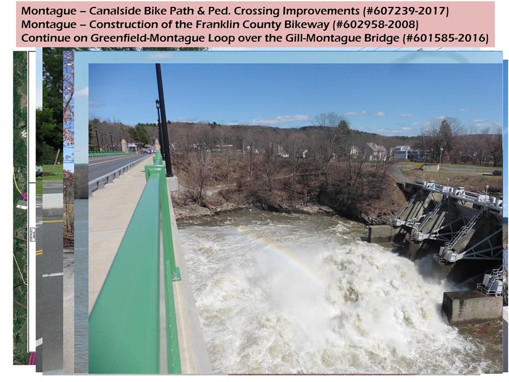
3 WITH CONSIDERATION TO TIME -I HAVE DIVIDED D2 INTO A NORTHERN SECTION & SOUTHERN SECTION FOR THIS PRESENTATION. THE NORTHERN SECTION OF D2 INCLUDES COMMUNITIES IN FRANKLIN COUNTY AND IN MRPC. IT MIGHT DIFFICULT FOR YOU TO SEE FROM THE DISTANCE, BUT THIS MAP HIGHLIGHTS SOME DIFFERENT BICYCLE TRAILS: FOR EXAMPLE: BLUE LINES SHOW AN EXISTING FACILITY SUCH AS THE FRANKLIN COUNTY BIKEWAY -CT RIVER ROUTE JOINS THE CANALSIDE TRAIL THAT IS PART OF THE GREENFIELD- MONTAGUE LOOP -THERE IS THE LEVERETT-MONTAGUE ROUTE THAT JOINS THE NORTHFIELD CONNECTOR AND THE NORTH CENTRAL PATHWAY IS A SHARED USE PATH IN WINCHENDON. THE RED LINES REPRESENT ENVISIONED PATHS SUCH AS ON-ROAD FACILITIES. THESE YELLOW LINES ARE CURRENTLY UNDER REVIEW, SUCH AS A SHARED USE PATH FOR THE MILLERS RIVER GREENWAY IN ORANGE, AND THE WARE RIVER RAIL TRAIL IN TEMPLETON. NOW, I WILL TAKE YOU ON A QUICK TOUR OF 5 PROJECTS IN THE NORTHERN AREA: -3 ARE LOCATED FAIRLY CLOSE EACH OTHER IN MONTAGUE (WHICH HAVE BEEN COMPLETED), -AND 2 ARE PLANNED AS FUTURE PROJECTS -1 IN NORTHFIELD & 1 IN GREENFIELD. 3
4 4
, POLYSTYRENE APPROACHES (BEGINNING OF MAY 2017): UNIQUE SITUATION IN THIS AREA DUE TO HIGH WATER TABLE & ARTESIAN CONDITIONS WHERE WATER IS IN A CONFINED")
5 INCLUDED IN A LARGER PROJECT FOR HACHERY ROAD & GREENFIELD ROAD IMPROVEMENTS. PICTURES INCLUDE CONCRETE DECK POUR (4/28/17), POLYSTYRENE APPROACHES (BEGINNING OF MAY 2017): UNIQUE SITUATION IN THIS AREA DUE TO HIGH WATER TABLE & ARTESIAN CONDITIONS WHERE WATER IS IN A CONFINED AQUIFER CONTAINING GW UNDER PRESSURE THAT FLOWS OUT TO THE SURFACE. THIS CONDITION WREAKED HAVOC AT THIS SITE, AND CAUSED THE BRIDGE TO BE SHUT DOWN ABOUT 10 YEARS AGO WHEN IT WAS DISCOVERED THAT THE RAILINGS GOT SEPARATED, SO THE BRIDGE WAS REMOVED TO PROTECT THE RR UNDERNEATH. THE POLYSTYRENE APPROACHES ARE LIGHTER THAN THE USUAL PAVEMENT APPROACHES, AND THIS NEW INNOVATION WILL CAUSE LESS PRESSURE ON THE WATER TO RISE, THEREBY MAKING IT LASTING LONGER. THIS RECENTLY COMPLETED BICYCLE/PEDESTRIAN BRIDGE WAS OPENED FOR PUBLIC USE ON 7/1/2017, AND SHOULD HAVE RIBBON-CUTTING CEREMONY THIS FALL. 5

6 LOCATED IN NORTHERN MA OVER CT RIVER (CLOSE TO NH & VT BORDERS) Historic Steel Truss CANTILEVER (ARCHED) BRIDGE (Donated in 1904 Francis Robert Schell in memory of his parents Closed in 1985 due to structural integrity STRUCTURE LENGTH = 515 FT/ HAS 3 SPANS BUT MAIN SPAN BETWEEN PIERS = 352 FT/ WIDTH = 19 FT WSP (MassDOT CONSULTANT GAVE A PI MEETING ON 6/1/2017 WHERE THEY SHARED 8 CONCEPTS OF LONG SPAN PED BRIDGE TYPES & SHARED ADV/DISADV TO GAIN FEEDBACK. NEED 352 FT FOR THE SPAN, WHICH POSES DIFFICULTY FOR CURRENT PIER AND ABUTMENT LAYOUT IF INTERESTED IN FEEDBACK SEE ME AFTER MEETING 6

7 7

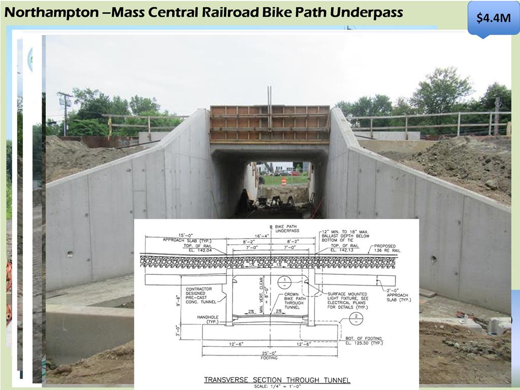
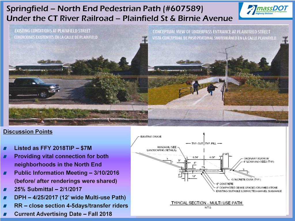
8 THE SOUTHERN SECTION OF D2 INCLUDES COMMUNITIES IN PIONEER VALLEY & CMRPC. REMEMBER RED LINES INDICATE ENVISIONED FACILITIES, AND THE BLUE LINES INDICATE EXISTING FACILITIES SUCH AS THE MANHAN RAIL TRAIL IN EASTHAMPTON THAT CONNECTS TO THE MASS CENTRAL BIKEWAY IN NORTHAMPTON, AND CONTINUES TO HADLEY ON THE NORWOTTUCK RAIL TRAIL. THE YELLOW LINES SHOW FUTURE AREAS UNDER REVIEW SUCH AS THE CT RIVERWALK IN WEST SPRINGFIELD. SO LET S TAKE A QUICK TOUR, AND I WILL SHOW YOU SOME INTERESTING PROJECTS FOR: - 2 RECENTLY COMPLETED PROJECTS IN BARRE & NORTHAMPTON, - 2 PROJECTS IN THE NEAR FUTURE IN SPRINGFIELD AND AGAWAM/W. SPRINGFIELD, -A CURRENT SRTS PROJECT IN SOUTHAMPTON & FINALLY, AN UPCOMING PROJECT IN WESTFIELD. 8

9 9
10 10
11 11

12 NOTE: THE GREEN WILL NOT BE HERE ON THE BRIDGE. 12

13 Bid Price -$1M Construction Began 3/27/

14 14

15 THE RIVER ROLL & STROLL EVENT WAS THE FIRST OF ITS KIND IN MA. IT INVOLVED CLOSING THE BRIDGE THAT CARRIES RT 116 OVER THE CT RIVER IN ORDER TO PROMOTE WALKING, BIKING, & USING ALTERNATIVE MODES OF TRANSPORTATION! DURING THE CLOSURE, SIGNS & JERSEY BARRIERS WERE ERECTED FOR A TRAFFIC DETOUR OVER THE ROUTE 202 BRIDGE, SO YOU CAN SEE THIS TOOK A LOT OF COORDINATION. ARE ANY OF YOU AWARE OF THIS EVENT OR DID YOU ATTEND (RAISE YOUR HAND)? -HOLYOKE & SOUTH HADLEY COORDINATED THE FUND RAISING, AND PUBLIC OUTREACH FOR (ABOUT 75) VOLUNTEERS FROM BOTH COMMUNITIES. D2 WORKED WITH THEM FOR A PERMIT TO CLOSE THE BRIDGE TO TRAFFIC FOR 4 HOURS (11AM-3PM) ON A SUNDAY. AS YOU CAN IMAGINE, THERE HAD TO BE A LOT OF COORDINATION ESPECIALLY INVOLVING THEIR POLICE & PUBLIC WORKS DEPARTMENTS, - AND THE EMERGENCY RESPONSE PERSONNEL FOR SAFETY COORDINATION, - A MILITARY GUARD FIRE THEIR MUSKETS 3X, - THERE WAS A VIETNAM VETERAN MEMORIAL BRIDGE NAMING CEREMONY (COMPLETE W/ A BALD EAGLE FLY OVER-I DON T KNOW HOW THEY DID THAT!) - THERE WERE MANY TYPES OF MUSIC AT THE EVENT INCLUDING THE SOUTH HADLEY MIDDLE SCHOOL BAND. 15

16 THERE WERE ALL KINDS OF FUN ACTIVITIES TO DO INVOLVING: - DANCING/ LIVE MUSIC BY A VARIETY OF BANDS INCLUDING A DANCING SEA LAMPHREY, - MASSDOT INSTALLED A TEMPORARY SEPARATED BIKE LANE, AND HAD A TABLE TO DISTRIBUTE FREE GIFTS/INFORMATION, - GAVE THE PUBLIC AN OPPORTUNITY TO TAKE A BIKE SURVEY REGARDING SAFETY MEASURES, AND LOCATIONS FOR FUTURE FACILITIES, - AND THERE WAS HOLA-HOOPING, BUBBLE-MAKING, BIKE DECORATING, CHALK DRAWING, FACE-PAINTING, AND OF COURSE - ENJOYING THE VIEW OF THE HOLYOKE DAM FROM THE BRIDGE WHERE YOU COULD EXPERIENCE THE CT RIVER IN A WHOLE NEW WAY. 16
Non-Motorized Overpass at SR 5/US1
 Non-Motorized Overpass at SR 5/US1 And SR 97/SW th Street (Bird Road) Executive Summary March 9, 17 Prepared By: MARLIN Engineering Inc 17 NW th Avenue, Ste. 1 Plantation, FL 33313 P: 35.77.7575 www.marlinengineering.com
Stakeholders Advisory Working Groups (SAWGs) Bridge and Bike / Pedestrian SAWG (#15)
 Bridge and Bike / Pedestrian SAWG (#15)") Presentation Bridge and Bike / Pedestrian SAWG (#15) Tappan Zee Bridge/I-287 Corridor Project December 8, 2009 Slide 1. This is the title slide for the Tappan Zee Bridge Joint Stakeholders Advisory Working
Presentation Bridge and Bike / Pedestrian SAWG (#15) Tappan Zee Bridge/I-287 Corridor Project December 8, 2009 Slide 1. This is the title slide for the Tappan Zee Bridge Joint Stakeholders Advisory Working
Hennepin County Bicycle and Pedestrian Planning
 Hennepin County Bicycle and Pedestrian Planning 1 Value of bicycle and sidewalk systems Safety Livability Mobility Health Personal Finances Economic Sustainability Clean Air Recreation Parking and congestion
Hampton Roads Pedestrian and Bicycle Advisory Committee
 Hampton Roads Pedestrian and Bicycle Advisory Committee Virginia Bicycle and Pedestrian Advisory Committee April 22, 2015 Carl E. Jackson, AICP Transportation Planning Specialist Hampton Roads District
N.Y. / REGION INFRASTRUCTURE Going Up! A Bridge Makes Way for Bigger Ships
 N.Y. / REGION INFRASTRUCTURE Going Up! A Bridge Makes Way for Bigger Ships By KATE ASCHERMARCH 21, 2014 Advertisement When it opened in 1931, the Bayonne Bridge with its parabolic arch connecting Staten
DRAFT SHARED USE PATH AND ROADWAY INTERSECTIONS IN THE PIONEER VALLEY DECEMBER Prepared under the direction of the Pioneer.
 DRAFT DECEMBER 2018 AT-GRADE2018 SHARED USE PATH AND ROADWAY INTERSECTIONS IN THE PIONEER VALLEY Norwottuck Branch Mass Central Rail Trail approaching East Street in Hadley Prepared under the direction
Living Streets Policy
 Living Streets Policy Introduction Living streets balance the needs of motorists, bicyclists, pedestrians and transit riders in ways that promote safety and convenience, enhance community identity, create
N E W P O R T L A N D Y O R K C I T Y. t o
 P O R T L A N D t o N E W Y O R K C I T Y Eastern Trail: Scarborough Marsh bridge Eastern Trail, ME NH Seacoast Greenway Hampton Old Eastern Marsh Trail: Salisbury, MA Clipper City Trail: bridge over Low
Clay Street Bridge Replacement Project
 Clay Street Bridge Replacement Project Frequently Asked Questions (FAQs) The project is located in downtown Placerville on Clay Street between US Highway 50 and Main Street and Cedar Ravine Road. The proposed
Bicycle Pedestrian Master Plan Pre Bid Meeting Portsmouth, NH August 15, 2013
 Bicycle Pedestrian Master Plan Pre Bid Meeting Portsmouth, NH August 15, 2013 2005 Master Plan GOAL: Provide for safe and convenient bicycle and pedestrian circulation throughout the City. Develop a city
WELCOME. FM 2818 (Harvey Mitchell Parkway) Open House. Tuesday, Nov. 14, 2017
 Open House. Tuesday, Nov. 14, 2017") WELCOME FM 2818 (Harvey Mitchell Parkway) Open House Tuesday, Nov. 14, 2017 Why am I here? Review the planned improvements Provide comments on the proposed project The environmental review, consultation,
WELCOME FM 2818 (Harvey Mitchell Parkway) Open House Tuesday, Nov. 14, 2017 Why am I here? Review the planned improvements Provide comments on the proposed project The environmental review, consultation,
Austin Avenue Bridges Project. Public Meeting Summary
 Austin Avenue Bridges Project Public Meeting Summary June 29, 2016 Red Table Safety and Connectivity Notes: 1. Would like to see forensic report evaluations 2. What is the lifespan? 3. Extend safety considerations
Hampton Roads Pedestrian and Bicycle Advisory Committee
 Hampton Roads Pedestrian and Bicycle Advisory Committee HRTPO Transportation Technical Advisory Committee November 6, 2013 Carl E. Jackson III, AICP Transportation Planning Specialist Hampton Roads District
10A. DATE: October 5, Pedestrian and Bicycle Advisory Committee. Kevin Colin, Deputy Planning Manager Curt Bates, City Engineer
 10A DATE: October 5, 2016 TO: PREPARED BY: SUBJECT: Pedestrian and Bicycle Advisory Committee Kevin Colin, Deputy Planning Manager Curt Bates, City Engineer Discussion and Provide Comments, Associated
Methuen Rail Trail City of Methuen Public Information Meeting Methuen City Hall
 Methuen Rail Trail City of Methuen Public Information Meeting Methuen City Hall September 22, 2016 Agenda 1 Welcome and Introductions 2 Methuen Rail Trail Update 3 What is a Rail Trail? 4 Conceptual Design
FY 2006 TRANSPORTATION CAPITAL PROGRAM
 Eden Lane Bridge over Whippany River NS9908 The existing structure was built in 1972 as a temporary single-span structure. The bridge consists of simply supported steel acrow panel trusses and is supported
MASSACHUSETTS AVENUE BRIDGE REPLACEMENT PROJECT APRIL 25, 2018
 MASSACHUSETTS AVENUE BRIDGE REPLACEMENT PROJECT APRIL 25, 2018 AGENDA Introductions Project Benefits Progress to Date Schedule for Remaining Work Phase 3 Activities, Impacts & Traffic Detours Phase 4 Activities
Bicycle-Pedestrian Master Plan Update
 Bicycle-Pedestrian Master Plan Update Planning & Zoning Commission November 29, 2017 Overview Project Purpose & Scope Project History Plan Vision & Goals Chapter 5: Making Connections-Beyond the Path Next
CHAPTER 1 INTRODUCTION
 CHAPTER 1 INTRODUCTION Chapter Table of Contents THE 2017 HOUSTON BIKE PLAN 1-1 HOUSTON BIKEWAYS PROGRAM 1-2 HISTORY OF BICYCLE PLANNING IN HOUSTON 1-3 BICYCLE LEVEL OF COMFORT 1-3 EXISTING PLANS, PROGRAMS
Overview. Illinois Bike Summit IDOT Complete Streets Policy Presentation. What is a Complete Street? And why build them? And why build them?
 Overview Illinois Bike Summit IDOT Complete Streets Policy Presentation Aren Kriks, P.E. District One Bicycle Coordinator and Bureau of Programming Project Engineer History of Complete Streets IDOT Policy
RiNo Railroad Crossing Connectivity Analysis. Stakeholder Workshop June 29, 2017
 RiNo Railroad Crossing Connectivity Analysis Stakeholder Workshop June 29, 2017 Ideas and Considerations Presented at Stakeholder Workshop Primary Focus: 38 th Street (between Walnut & Wynkoop) 1 Basic
MassDOT s Transportation Choice and Healthy Transportation Policy Initiatives
 MassDOT s Transportation Choice and Healthy Transportation Policy Initiatives Jackie DeWolfe, Director of Sustainable Mobility, MassDOT Michelle Danila, Complete Streets Engineer, MassDOT ACEC April 2018
Public Transportation and Bicycle & Pedestrian Stakeholder Webinar. April 11, :30 PM
 Public Transportation and Bicycle & Pedestrian Stakeholder Webinar April 11, 2013 1:30 PM Public Transportation and Bicycle & Pedestrian Webinar April 11, 2013 1:30 PM MULTIMODAL TRANSPORTATION PLAN Vision,
FALL 2014 WORKSHOPS TAKEAWAYS
 SFMTA WORKSHOP FEEDBACK The SFMTA and partner agencies are continuing to utilize feedback from the Fall 2014 workshops to inform priorities and next steps for the Embarcadero Enhancement Project. Throughout
Getting Your SRTS Project Funded. Ryan Snyder
 Getting Your SRTS Project Funded Ryan Snyder Steps in Submitting a Successful Application 1. Stakeholder outreach: create a SRTS coalition 2. Develop a comprehensive plan and program with all 5 Es 3. Conceive
TRANSPORTATION TRAINING TOPICS. April 6, 2010
 TRANSPORTATION TRAINING TOPICS April 6, 2010 Roles of Transportation Providers Context and Policy Makers Division of Transportation and Traffic Other City Operations Other Transportation Operators CMA
City of Springboro Bicycle & Pedestrian Plan
 City of Springboro Bicycle & Pedestrian Plan Public Visioning Workshop Documentation of Input August 24, 2012 List of Figures Public Input A Public Visioning Workshop was held on August 7, 2012 from 6:00
Walnut Street Extension Streetscape Improvement Project Funding Authorization Analysis Report
 Walnut Street Extension Streetscape Improvement Project Funding Authorization Analysis Report March 22, 2017 Prepared for: Agawam City Council, Mayor Richard A. Cohen, Christopher Golba DPW Superintendent,
Rail Station Fact Sheet Downtown Carrollton Station
 Rail Station Fact Sheet Downtown Carrollton Station Station Overview Downtown Carrollton Station is located at East Belt Line Road and Broadway Street near the historic Downtown Carrollton Square. The
Ulster County Non-motorized Transportation Plan
 Ulster County Non-motorized Transportation Plan NTAC Meeting NOTES Ulster County Community College Date 08.29.07 Time: 1:00 p.m. - 3:00 p.m. Agenda Welcome /Intro Project Status Report o Project is on
Traffic Signs and Signals
 CHAPTER FOUR Traffic Signs and Signals Traffic signs control traffic flow, making streets and highways safer for drivers, bicyclists and pedestrians. These signs, which are posted by the Indiana Department
Outreach Sessions for the Transportation Plan Update. April 29, May 13, and May 20
 Outreach Sessions for the Transportation Plan Update April 29, May 13, and May 20 Our Transportation Plan Identifies projects that will improve travel for our citizens and businesses over the next 25 years
Welcome to the Sellwood Bridge Project Open House!
 Welcome to the Sellwood Bridge Project Open House! 5:30 7:30 pm Please sign in here Information stations and project staff are located throughout the room. Goals for Tonight s Meeting: Learn how the Preferred
Bikeway action plan. Bicycle Friendly Community Workshop March 5, 2007 Rochester, MN
 Bikeway action plan Summary The was held on March 5, 2007 at the Rochester Mayo Civic Center. The workshop was hosted by Rochester-Olmsted County Planning Department in collaboration with the League of
Access Routes from US 101 to the Richmond San Rafael Bridge
 Access Routes from US 101 to the Richmond San Rafael Bridge TAM Board Meeting January 28, 2016 RSRB Project Elements Eastbound Third Lane: Sir Francis Drake Blvd. to Marine Street 10 ft Barrier Separated
1.0 EXECUTIVE SUMMARY
 1.0 EXECUTIVE SUMMARY The Active Transportation Plan is a guide to accomplish the Town s vision for developing a network of sidewalks, on-road bicycle facilities, and trails that allow for safe and convenient
Florida DOT Case Study
 Florida DOT Case Study 1 Background In 2013, MetroPlan Orlando became one of the first planning agencies in the world to use Strava Metro data to make better decisions about where to improve bicycle and
Emergency Response Support Signage on Multi-Use Trails Plan
 DRAFT ( ) Emergency Response Support Signage on Multi-Use Trails Plan Prepared for: SATS Multi-Use Trails Jurisdictions Committee Table of Contents Introduction... 3 Mileage Markers... 4 Rest Stop Identifiers...
Our vision for Chicago s bike network focuses on three types of routes:
 Bikeways for All In recent years, bicycling in Chicago has been transformed from a fringe activity to a mainstream mode of transportation, thanks in large part to investments made by city leaders in new
Statewide Pedestrian and Bicycle Transportation Plan and Economic Impact Study. Kick off Meeting November 28, Your Planning Team
 Statewide Pedestrian and Bicycle Transportation Plan and Economic Impact Study Kick off Meeting November 28, 2018 Your Team Alta + Design Statewide planning efforts in 18 states Bike/ped network planning
S A F E R O U T E S T O S C H O O L H E R M A N TOW N S C H O O L S A N D P R O C TO R S C H O O L S P L A N A P P R OVA L S
 S A F E R O U T E S T O S C H O O L H E R M A N TOW N S C H O O L S A N D P R O C TO R S C H O O L S P L A N A P P R OVA L S WHAT IS SAFE ROUTES TO SCHOOL? In 1969, nearly 50% of children walked or rode
Perryville TOD and Greenway Plan
 Perryville TOD and Greenway Plan Greenway Glossary Pathway: A bicycle and pedestrian path separated from motorized vehicular traffic by an open space, barrier or curb. Multi-use paths may be within the
SANTA CLARA COUNTYWIDE BICYCLE PLAN August 2008
 SANTA CLARA COUNTYWIDE BICYCLE PLAN August 2008 To assist VTA and Member Agencies in the planning, development and programming of bicycle improvements in Santa Clara County. Vision Statement To establish,
Agenda. Overview PRINCE GEORGE S PLAZA METRO AREA PEDESTRIAN PLAN
 PRINCE GEORGE S PLAZA METRO AREA PEDESTRIAN PLAN May 28, 2008 Agenda Welcome and introductions Project overview and issue identification Planning context and strengths Design challenges and initial recommendations
Watertown Complete Streets Prioritization Plan. Public Meeting #1 December 14, 2017
 Watertown Complete Streets Prioritization Plan Public Meeting #1 December 14, 2017 Goals for Public Meeting Overview of MassDOT Complete Streets Funding Program Educate the community on Complete Streets
Appendix C 3. Bicycle / Pedestrian Planning
 Appendix C 3. Bicycle / Pedestrian Planning BICYCLE/PEDESTRIAN PLANNING 2005 Master Plan GOAL: Provide for safe and convenient bicycle and pedestrian circulation throughout the City. Develop a city-wide
LANCASTER CITY BICYCLE NETWORK
 LANCASTER CITY BICYCLE NETWORK Downtown Merchants Meeting Wednesday, July 19, 2017 http://www.lancasteratp. DOWNTOWN WALKABILITY ANALYSIS What changes can be made, in the least amount of time, and for
July 5, Arthur R. Ware, Jr. Elementary School 2017 Safe Routes to School Walkabout Report
 July 5, 2017 Arthur R. Ware, Jr. Elementary School 2017 Safe Routes to School Walkabout Report 1 Walkabout Report Introduction On April 28, 2017, City, School, and SAWMPO staff met to conduct a Safe Routes
COMPLETE STREETS DURING CONSTRUCTION
 COMPLETE STREETS DURING CONSTRUCTION MAINTAINING ACCESSIBILITY FOR ALL Presented by Robbie Burgess, P.E., PTOE Associate Principal Construction Services Manager Howard Stein Hudson rburgess@hshassoc.com
Oakland Bicycle and Pedestrian Advisory Committee, September 19, 2013 Meeting
 Oakland Bicycle and Pedestrian Advisory Committee, September 19, 2013 Meeting Attendees: Brian Toy, Chris Hwang, Chris Kidd, Daniel Schulman, Dave Campbell, Jason Patton, Jennifer Stanley, Midori Tabata,
Bicycle and Pedestrian Connectivity Study Phase 2
 Connectivity Study Phase 2 Process PROCESS OUTCOMES Phase Prepared By STEP I Public Participation and Outreach 1. RTP Outreach activities, and development of the Bike and Ped Task Force Phase 1 2011 OCPC
Congestion Management Process
 CMP Congestion Management Process Congestion Management Process for the Pioneer Valley July 2010 Prepared by: The Pioneer Valley Planning Commission This document was prepared under contract with the Massachusetts
MAG Town of Cave Creek Bike Study Task 6 Executive Summary and Regional Significance Report
 Page 1 MAG Town of Cave Creek Bike Study Task 6 Executive Summary and Regional Significance Report August 1, 2012 MAG Project #481 Page 2 Task 6 Executive Summary and Regional Significance Report Introduction
Welcome. Thank you for your interest in the Lewis & Clark Viaduct Concept Study
 Welcome Thank you for your interest in the Lewis & Clark Viaduct Concept Study Please use the arrows in the upper left hand corner to navigate through the presentation. Use the envelope icon to ask a question
MASTER BICYCLE AND PEDESTRIAN PLAN
 WELCOME! PLEASE FEEL FREE TO REVIEW THE EXHIBITS THE PRESENTATION WILL BEGIN AT 6:00 PM VILLAGE OF NORTHBROOK MASTER BICYCLE AND PEDESTRIAN PLAN DRAFT EXISTING CONDITIONS REPORT AND PUBLIC MEETING WELCOME!
Agenda Item # Page # RECOMMENDATION
 TO: FROM: SUBJECT: CHAIR AND MEMBERS CIVIC WORKS COMMITTEE MEETING ON FEBRUARY 2, 2016 JOHN BRAAM, P. ENG. MANAGING DIRECTOR, ENVIRONMENTAL & ENGINEERING SERVICES AND CITY ENGINEER FIELD MARSHAL WOLSELEY
Master Plan Joint Workgroup Meeting. Meeting Summary. Date: Sunday, November 5, :00pm 8:00pm Location: Ended at The Big Field at Dix Park
 Master Plan Joint Workgroup Meeting Date: Sunday, November 5, 2017 Time: 6:00pm 8:00pm Location: Ended at The Big Field at Dix Park Meeting Summary On Sunday, November 5, the Dix Park City Staff held a
NM-POLICY 1: Improve service levels, participation, and options for non-motorized transportation modes throughout the County.
 Transportation PRINCE WILLIAM COUNTY 2008 COMPREHENSIVE PLAN NON-MOTORIZED PLAN CONTENTS Goals, Policies, and Action Strategies Table 4 (Bike Facility Classifications and Descriptions) Table 5 (Bike Facility
Willamette River Transit Bridge. Portland - Milwaukie Light Rail Willamette River Bridge Citizen Advisory Committee
 Portland - Milwaukie Light Rail Willamette River Bridge Citizen Advisory Committee 05.21.09 Bridge Type Status Update Bicycle Pedestrian Path Width Bridge Type Status Update WRBAC Recommendation: Cable
Bicycling Routes on Provincial Roads Policy
 Bicycling Routes on Provincial Roads Policy Policy Statement Rationale To support bicycling in Nova Scotia, the Department of Transportation and Infrastructure Renewal (TIR) may designate some portions
US Route 24 Eastbound (Quincy Memorial Bridge) Over the Mississippi River
 Over the Mississippi River") Purpose and Need March 2015 US Route 24 Eastbound (Quincy Memorial Bridge) Over the Mississippi River Adams County - Quincy, IL Marion County, MO Region 4 District 6 Table of Contents I. Purpose of the
Purpose and Need March 2015 US Route 24 Eastbound (Quincy Memorial Bridge) Over the Mississippi River Adams County - Quincy, IL Marion County, MO Region 4 District 6 Table of Contents I. Purpose of the
City of Madison: 2017 Capital Budget Capital Improvement Plan
 Capital Improvement Plan Project Summary Bikeways Program 779,000 751,000 630,000 670,000 703,000 703,000 Cannonball Path 210,000 - - 730,000 - - Cap City Trail 1,140,000-360,000 - - 910,000 Ice Age Junction
Traffic Engineering Update on Bike/Ped Topics. Marc Lipschultz, P.E. PTOE Central Office Traffic Engineering Division
 Traffic Engineering Update on Bike/Ped Topics Marc Lipschultz, P.E. PTOE Central Office Traffic Engineering Division Bicycle/Pedestrian Advisory Committee August 3, 2016 Agenda Share the Road / Bikes May
Bicycle and Pedestrian Connectivity Study. Old Colony Planning Council
 Bicycle and Pedestrian Connectivity Study Old Colony Planning Council Outline Why consider bike/peds in road designs? Why are measures needed? Connecting Land Use with Transportation Evaluation Tools:
Houma-Thibodaux Metropolitan Planning Organization STP<200K Funding Application APPLICATION
 APPLICATION HOUMA-THIBODAUX METROPOLITAN PLANNING ORGANIZATION (HTMPO) FOR SURFACE TRANSPORTATION PROGRAM (STP
BIKE PLAN CONTENTS GATEWAY
 CONTENTS Acknowledgments...vii Great Rivers Greenway District Board of Directors... vii Great Rivers Greenway District Staff... vii Project Consultants... vii Committees... viii Citizens Advisory Committee
Replacement of N. Carlin Springs Road Bridge over George Mason Dr.
 Replacement of N. Carlin Springs Road Bridge over George Mason Dr. Approximate schedule with phases and proposed Maintenance of Travel (MOT) plans February 2017 Project Elements Removal of existing bridge
BOLAND DRIVE PATH PROJECT. Martin Le Jack Reilly Paul Rodriguez Allison Rotella Maria Wilson
 BOLAND DRIVE PATH PROJECT Martin Le Jack Reilly Paul Rodriguez Allison Rotella Maria Wilson INTRODUCTION TO PROJECT The purpose: to construct a multi-purpose path, which will connect two existing bike
City of Madison, East Johnson Street North Baldwin Street to First Street Local Street Dane County
 City of Madison, East Johnson Street North Baldwin Street to First Street Local Street Dane County Public Involvement Meeting Thursday, November 10, 2016 5:30 to 7 P.M. Festival Foods 810 E. Washington
Route 47 (North Main Street) Reconstruction
 Reconstruction") TOWN OF SUNDERLAND Route 47 (North Main Street) Reconstruction Presented by Lou Rabito, P.E. Presented to Town of Sunderland June 11, 2018 Project Overview MassDOT Project No. 607245 Resurfacing and Related
TOWN OF SUNDERLAND Route 47 (North Main Street) Reconstruction Presented by Lou Rabito, P.E. Presented to Town of Sunderland June 11, 2018 Project Overview MassDOT Project No. 607245 Resurfacing and Related
Information on display. Inside this handout. Triangle Area revisions. Project need displays. Preferred alternative on aerial maps
 Public information meeting #4 4 to 7 p.m., September 30, 2009 Hales Corners Welcome Thank you for attending this public information meeting for the WIS 100 Corridor Study. Your interest and comments are
CHECKLIST 5: ROADWORK TRAFFIC SCHEME AUDIT
 CHECKLIST 5: ROADWORK TRAFFIC SCHEME AUDIT 5.1 General items 5.1.1 Alignment Are the roadworks located safely with respect to horizontal and vertical alignment? If not, does works signing cater for this?
MONTGOMERY COUNTY PLANNING DEPARTMENT THE MARYLAND-NATIONAL CAPITAL PARK AND PLANNING COMMISSION
 MONTGOMERY COUNTY PLANNING DEPARTMENT THE MARYLAND-NATIONAL CAPITAL PARK AND PLANNING COMMISSION MCPB Item No. 4 Date: 09-10-15 Scope of Work for the Bicycle Master Plan David Anspacher, Planner/Coordinator,
Public Works Committee Meeting Richard E. Mastrangelo Council Chamber November 20, 2017
 Public Works Committee Meeting Richard E. Mastrangelo Council Chamber November 20, 2017 Purpose of Meeting Why are we here? Project Recap/Updates Project Limits/Segments Road Diet Concept Lessons Learned
Trail Running Western Massachusetts By Ben Kimball
 Trail Running Western Massachusetts By Ben Kimball Northeast Adventures: TRAIL RUNNING Western Massachusetts - Announcement about the upcoming publication of the Trail Running Western Massachusetts guidebook.
Cycle Track Design Best Practices Cycle Track Sections
 Design Best Practices Sections It is along street segments where the separation and protection methods of cycle tracks offer more comfort than conventional bicycle lanes, and are more attractive to a wide
Pennsylvania Avenue (CR 484) Design Alternatives Study
 Design Alternatives Study") MEMORANDUM Pennsylvania Avenue (CR 484) Design Alternatives Study Prepared for: APRIL 2016 Prepared By TABLE OF CONTENTS Project Background... 2 Previous Concept... 2 Existing Conditions... 4 New Alternatives...
MEMORANDUM Pennsylvania Avenue (CR 484) Design Alternatives Study Prepared for: APRIL 2016 Prepared By TABLE OF CONTENTS Project Background... 2 Previous Concept... 2 Existing Conditions... 4 New Alternatives...
City of McHenry Bicycle and Pathway System Plan
 Bicycle and Pathway System Plan Prepared by: City of McHenry September, 2004 Table of Contents Introduction... 3 Goals and Objectives of the Plan... 4 History... 5 Summary of the Planning Process for the
Rail Station Fact Sheet University of Dallas Station
 Rail Station Fact Sheet University of Dallas Station Station Overview University of Dallas Station is located on John Carpenter Freeway and west of Loop 12 across from the University of Dallas in Irving.
I-90 ALLSTON INTERCHANGE A MULTIMODAL TRANSPORTATION PROJECT MEPA CONSULTATION MEETING NOVEMBER 20, 2014 BRIGHTON HIGH SCHOOL
 I-90 ALLSTON INTERCHANGE A MULTIMODAL TRANSPORTATION PROJECT MEPA CONSULTATION MEETING NOVEMBER 20, 2014 BRIGHTON HIGH SCHOOL Today s Agenda 1. 2. 3. 4. 5. Overview of the MEPA Process Project Overview
Physical Implications of Complete Streets Policies
 Presentation Overview Physical Implications of Complete Norm Cox, ASLA, LLA Landscape Architect Ann Arbor, Michigan, 10:45 to Noon What Are Complete Streets? What Matters to Bicyclists and Pedestrians
Golden s Plan. For the Highway 6 & 93 Corridor
 Golden s Plan For the Highway 6 & 93 Corridor Purpose of the Study Accommodate regional traffic needs on Highways 6 and 93, as defined by the Northwest Quadrant Feasibility Study. Find a solution that
Bicycle Master Plan Goals, Strategies, and Policies
 Bicycle Master Plan Goals, Strategies, and Policies Mobilizing 5 This chapter outlines the overarching goals, action statements, and action items Long Beach will take in order to achieve its vision of
Implementation Report # False Creek Bridges
 Implementation Report #1 2013-04-24 False Creek Bridges ECONOMY PEOPLE ENVIRONMENT Intro Council Requested Report Back Topics Progress on Planning for Broadway Subway False Creek Bridges Local Transit
2009 Franklin County Bikeway Plan Update
 2009 Franklin County Bikeway Plan Update Franklin Regional Council of Governments 425 Main Street, Greenfield, MA 01301 413-774-3167 www.frcog.org 2009 Franklin County Bikeway Plan Update Franklin Regional
TOWN OF MORAGA. CAMINO PABLO & CANYON ROAD INTERSECTION IMPROVEMENTS Public Information Meeting February 20, 2019
 TOWN OF MORAGA CAMINO PABLO & CANYON ROAD INTERSECTION IMPROVEMENTS Public Information Meeting February 20, 2019 Edric Kwan, Public Works Director April Malvino Miller, BKF Project Design Manager Shawn
ACTIVE TRANSPORTATION
 ACTIVE TRANSPORTATION Mobility 2040 Supported Goals Improve the availability of transportation options for people and goods. Support travel efficiency measures and system enhancements targeted at congestion
City of Davis East Covell Corridor Plan
 Community Open House #2 January 22, 2014 6:00 8:00 p.m. Veterans Memorial Center, Club Room City of Davis Introduction The (ECCP) is a taking a comprehensive look at the existing transportation systems
Saskatchewan Drive Roadway Rehabilitation and Shared-Use Path Widening
 Saskatchewan Drive Roadway Rehabilitation and Shared-Use Path Widening We are here today to present the draft plan for the Saskatchewan Drive Roadway Rehabilitation and Shared-Use Path Widening project
Bridgewater Complete Streets Prioritization Plan and Pedestrian Safety Assessment
 Bridgewater Complete Streets Prioritization Plan and Pedestrian Safety Assessment Presented by Luciano Rabito Manager of Complete Streets Presented to Bridgewater, MA Wednesday, April 26, 2017 6:30 P.M.
May 13, pm Government Center Public Meeting Room City of Waltham Planning Department
 2 nd Annual Waltham Bicycle Update May 13, 2015 6-7pm Government Center Public Meeting Room City of Waltham Planning Department Agenda 6:00-7:00pm Welcome & Happy Waltham Bay State Bike Week! MA Bicycle
Mid Rivers Mall Drive Multi-Use Path (Rte. N to MO 364)
") Mid Rivers Mall Drive Multi-Use Path (Rte. N to MO 364) Sponsor St Peters Project No. RB19-000022 Project Type Other TOTAL FUNDING Total County Sponsor Federal $1,177,251.00 $238,179.00 $59,546.00 $879,526.00
Mid Rivers Mall Drive Multi-Use Path (Rte. N to MO 364) Sponsor St Peters Project No. RB19-000022 Project Type Other TOTAL FUNDING Total County Sponsor Federal $1,177,251.00 $238,179.00 $59,546.00 $879,526.00
SECTION TRAFFIC REGULATIONS
 SECTION 01550 TRAFFIC REGULATIONS PART 1 - GENERAL 1.01 OBJECTIVES A. The Contractor shall provide for safe movement of vehicular, bicycle and pedestrian traffic, including persons with disabilities in
State Bicycle and Pedestrian Advisory Committee Meeting. March 27, 2013 John Bolecek Statewide Bicycle and Pedestrian Planner
 State Bicycle and Pedestrian Advisory Committee Meeting March 27, 2013 John Bolecek Statewide Bicycle and Pedestrian Planner BPAC Meeting Agenda 1. Welcome and Introductions 2. Committee Structure 3. Status
FY STATEWIDE TRANSPORTATION IMPROVEMENT PROGRAM New Jersey Department of Transportation Projects
 Barclay Street Viaduct NS9807 NS9807 This project will provide for the rehabilitation of the Barclay Street Viaduct, from Route 19 to Marshall Street, in order to increase the weight load of the structure.
Appendix A. Knoxville TPO Greenway Signage Guidelines. Appendix A: Knoxville TPO Greenway Signage Guidelines Knox to Oak Ridge Greenway Master Plan
 Appendix A Knoxville TPO Greenway Signage Guidelines 75 Overview: Adequate signing and marking are essential on shared-use paths, especially to alert bicyclists to potential conflicts and to convey regulatory
Route 245 over Broad Run. The recently replaced bridge links The Plains and other communities in northern Fauquier to Interstate 66.
 28 VIRGINIA DEPARTMENT OF TRANSPORTATION \\ CULPEPER DISTRICT Route 245 over Broad Run. The recently replaced bridge links The Plains and other communities in northern Fauquier to Interstate 66. PROJECT
MINERAL AVENUE CORRIDOR ASSESSMENT STUDY IMPLEMENTATION STRATEGY
 MINERAL AVENUE CORRIDOR ASSESSMENT STUDY IMPLEMENTATION STRATEGY INTRODUCTION City Personnel Sign-in Sheet Comment Forms Please Write Down Any Feedback INTRODUCTION List of Topics for Presentation Study
Favorable factors for bicycling and walking investments & plan implemtation. Road Map for Success
 Favorable factors for bicycling and walking investments & plan implemtation Road Map for Success Learning Objectives Identify opportunities for funding and support of bicycle and pedestrian projects Explore
Broad Street Bicycle Boulevard City Council Study Session Summary
 Broad Street Bicycle Boulevard City Council Study Session Summary Overview: On August 15 th, 2017, a City Council Study Session was held to invite community input and request City Council guidance on a