|
|
|
- Theodore Morris
- 6 years ago
- Views:
Transcription
1

2
3


4

5

6
7

8

9

10
11
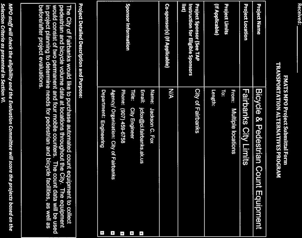
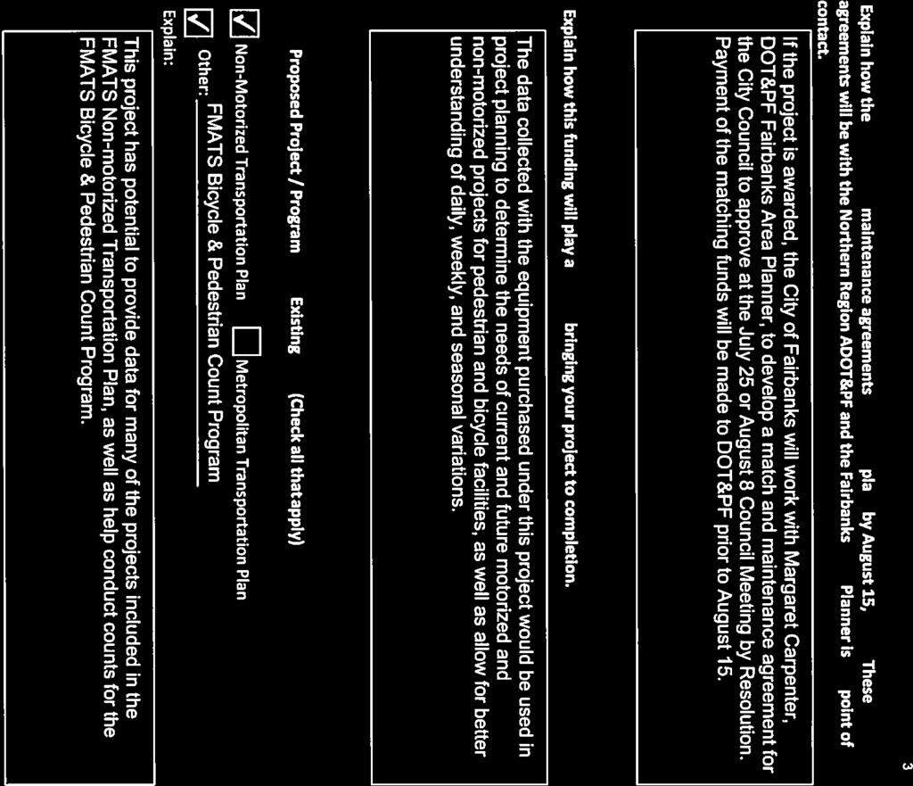
12 MEMORANDUM Date: June 28, 2016 Project #: To: From: Project: Subject: Donna Gardino, FMATS Jackson Fox, City of Fairbanks Andrew Ooms, PE FMATS Pedestrian and Bicycle Count Program TAP Application Support INTRODUCTION Kittelson & Associates, Inc. is actively working with FMATS to develop an enhanced pedestrian and bicycle count program. The planned program builds on the existing annual two-hour manual counts with a system of both permanent and mobile automated counters. These counters would provide continuous pedestrian and bicycle volume data at locations throughout the city, allowing for a better understanding of issues such as daily, weekly, and seasonal variations and evaluating project effectiveness. PERMANENT AUTOMATED COUNTERS Permanent counters are placed at high-traffic locations where pedestrians and vehicles are funneled into a single path. The most established counter technologies for this type of application is a passive infrared detector for pedestrians paired with inductive loops (either embedded in the pavement or surface mounted) detecting bicycles. Figure 1 below shows a passive infrared detector and infrared loops constructed on Anchorage s Chester Creek Trail during a repaving project. The detector and loop hardware is mounted in the adjacent post. Anchorage has recently installed 16 of these counters on their trail system with good results. Figure 2 shows the surface mount option. FILENAME: C:\USERS\AOOMS\DESKTOP\TEMP\19458 FMATS COUNTS\FMATS COUNT PROGRAM TAP SUPPORT MEMO.DOCX


13 FMATS Pedestrian and Bicycle Count Program Project #: June 28, 2016 Page 2 Figure 1 Anchorage Chester Creek Trail Passive Infrared Plus Inductive Loop Figure 2 Surface Mounted Induction Loops Two locations in the City of Fairbanks have been identified for permanent automated detectors. The Chena River Pedestrian Bridge: Due to the concrete approaches to the bridge, a surface mount induction loop system is recommended. These loops would be placed in the spring and removed before plowing operations start each year. The Chena Riverwalk between Peger Road and Moore Street. The asphalt surface allows for cost-effective embedded inductance loops. The specific location will be selected to minimize utility conflicts, minimize construction and power costs, and to best capture trail users. Kittelson & Associates, Inc. Anchorage, Alaska

14 FMATS Pedestrian and Bicycle Count Program Project #: June 28, 2016 Page 3 MOBILE AUTOMATED COUNTERS Temporary, or mobile, automated counters are the same technologies and provide the capabilities of permanent locations, but allow for the counters to be moved, dramatically expanding the coverage area of the counters as they can be deployed at several locations over the course of a count season. These mobile counters are also ideal for project before/after evaluations. Figure 3 shows a mobile passive infrared counter installed along a trail. Figure 3 Mobile Passive Infrared Counter Acquiring two mobile count systems consisting of passive infrared and surface inductive loop detectors is recommended. Two counters would allow for broad coverage as well as collecting data simultaneously on both sides of a roadway. COST ESTIMATES Preliminary cost estimates have been developed for each option and are shown in Table 1. The installation cost is a planning level estimate; actual installation costs will depend on specific location, power supply, pavement surface, and other factors. The equipment costs vary by width of detection zone, induction loop application, and directional count capability. This directional count ability is recommended as it provides key information on flows and insights into trip purpose and destination. Pricing information is provided by the vendor and is subject to change. Kittelson & Associates, Inc. Anchorage, Alaska
15 FMATS Pedestrian and Bicycle Count Program Project #: June 28, 2016 Page 4 Table 1 Count Equipment Cost Estimates Location Equipment Installation Costs Counter Costs Chena River Pedestrian Bridge Approach MULTI: PYRO Passive Infrared and Easy-ZELT Surface Loops (24') $5,000 $7,200 Chena River Walk East of Peger Road MULTI: PYRO Passive Infrared and ZELT Embedded Loops (12') $6,000 $4,800 Mobile Automated Counters (Each) PYRO-Box Passive Infrared (15') and Easy-ZELT Surface Loops (10') -- $8,500 Technical sheets for these count equipment are attached. Kittelson & Associates, Inc. Anchorage, Alaska


")
 Bidirectional Sensor: 18 mm x 40 mm x 90 mm (0.7 x 1.6 x 3.5 ) PYRO-Zoom Option: 18 mm x 40mm x 125 mm (0.7 x 1.6 x 4.")
 Cable Length 4 m (13 ) Detection Cone 30 cm at 2 meters / 60 cm at 4 meters (12 at 6 6 / 24 at 13 ) Cells Material High-density Polyethylene")
 from the ambient environment Installation Height PYRO Sensor for pedestrians: 80 cm (31 ) PYRO Sensor for horseback riders: 200")
16 Technical Sheet ECO-MULTI Processing and storage of data from different sensors Eco-MULTI is an innovative and versatile counter which is able to differentiate cyclists, pedestrians and motorized vehicles. The complete system brings together different sensor technologies, each sensor being dedicated to a single user type. The different signals are analyzed by an intelligent system, the SMART Connect, which is able to prioritize choices in order to classify the different user types. Counting System General Characteristics Technology PYRO Sensor: Passive Infrared Pyroelectric ZELT Sensor: Electromagnetic ZELT Battery Life 1 or 2 ZELT loops: 2 years More than 2 ZELT loops: 1 year Calibration/Adjustments Autocalibration Settings Sensitivity can be set up with delivered Software Direction recognition possible with a bidirectional Direction PYRO Sensor, or with option direction recognition by the ZELT Loops Covered Width Up to 6m (19.5 ) Data Backup 60-minute or 15-minute data recording interval Waterproofness IP 6.8. Memory 15-minute data recording interval: 330 days 60-minute data recording interval: 640 days Temperature Resistance -40 C to + 40 C (-40 F to 104 F) Physical Characteristics / Environment PYRO Sensor External Dimensions Unidirectional Sensor: Ø = 17 mm (0.7 ) L = 82 mm (3.2 ) Bidirectional Sensor: 18 mm x 40 mm x 90 mm (0.7 x 1.6 x 3.5 ) PYRO-Zoom Option: 18 mm x 40mm x 125 mm (0.7 x 1.6 x 4.9 ) Cells Dimensions Ø 10 mm (0.4 ) / Thickness: 0.7 mm (0.03 ) Cable Length 4 m (13 ) Detection Cone 30 cm at 2 meters / 60 cm at 4 meters (12 at 6 6 / 24 at 13 ) Cells Material High-density Polyethylene (HDPE) Sensor Body Material Bidirectional Sensor: Polyvinyl chloride Unidirectional Sensor: Thermoplastic sheath Connector RJ45 Min. Sensitivity 1 C (2 F) from the ambient environment Installation Height PYRO Sensor for pedestrians: 80 cm (31 ) PYRO Sensor for horseback riders: 200 cm (6 6 ) Setup Sensor positioned vertically, perpendicular to the path Beam Angle Medium-range PYRO Sensor: 7 PYRO-Zoom Sensor: 4,5 PYRO Sensor Europe Worldwide North America 4 rue Charles Bourseul Lannion, France St-Laurent Blvd Montreal, QC H2W 1Y5, Canada Tél : Fax : Phone: Toll Free: eco-counter@eco-counter.com Non contractual documentation. Specifications subject to change without notice.
 Width: 40 cm (15.7 ) Spacing between two loops installed side by side: 8 cm to 16 cm (3.1 to 6.2 ) Trenches Depth: 4 to 5 cm (1.5 to 1.9 ) Trenches Width: 0.5 cm to 2 cm (0.2 to 0.")
17 Technical Sheet ECO-MULTI ZELT Sensor Power Supply Settings Dimensions Installation 3.6 V / 17 Ah Sensitivity can be set up with delivered Software Length: 110 cm to 150 cm (3.6 to 4.9 ) Width: 40 cm (15.7 ) Spacing between two loops installed side by side: 8 cm to 16 cm (3.1 to 6.2 ) Trenches Depth: 4 to 5 cm (1.5 to 1.9 ) Trenches Width: 0.5 cm to 2 cm (0.2 to 0.8 ) Installation Example with PYRO for Pedestrians and two ZELT Inductive Loops for Bicycles Side View Non contractual documentation. Specifications subject to change without notice. Aerial View All Eco-Counter products are designed and manufactured in France. Europe Worldwide North America 4 rue Charles Bourseul Lannion, France St-Laurent Blvd Montreal, QC H2W 1Y5, Canada Tél : Fax : Phone: Toll Free: eco-counter@eco-counter.com


18 The PYRO Sensor is equipped with a lens that is sensitive to changes in infrared radiation allowing the system to detect the presence of a human body passing through its field of view. This sensor will count pedestrians and cyclists without distinction. The narrow field of view allows the system to count two people following each other closely. The system is capable of detecting the direction of travel of pedestrians and cyclists (optional feature). The battery will last for 10 years without needing to be charged. Ability to measure the direction of travel of pedestrians and cyclists Ten-year battery life Fast cyclists are detected Two people slightly staggered are detected separately The PYRO sensor is our most versatile counting system. It is ideal in many environments including: Sidewalks Pedestrian malls Park entrances Trails 3


19 In many natural settings, a wooden post can be a great way to camouflage the sensor. This post houses the PYRO sensor and is easy to install. The data logging components and battery are housed in a hidden, buried manhole adjacent to the trail. It is possible to purchase an all-in-one wooden post that houses both the sensor and the counting components for an additional $225. This housing option can simplify installation and ensure wireless data transmission even when the ground is covered with rain or snow accumulation. 4


20 With this system, the PYRO sensor and components are housed in an ultra-strong, metal, vandalproof post which is affixed to the pavement. This post is designed to blend into the urban environment. Color customization is available for an additional charge. This option is typically used where there is no post to mount a PYRO-Box. As with the PYRO-Box, this option is particularly resistant to vandalism. 5
 are housed in a vandal-proof")


21 With this system, the PYRO sensor and all related components (data logger, battery, and modem) are housed in a vandal-proof box. The advantage of this housing option is that the installation is easy enough that it can be installed permanently or moved from location to location. For better integration into the environment, color customization is available for an additional charge. 6

.")

22 The ZELT inductive loop technology makes it possible to analyze the electromagnetic signature of a bike by detecting each wheel. The frame of the bicycle is not analyzed, therefore carbon fiber bike frames with metal wheels are detected as well. Using 13 differentiation criteria, the ZELT technology is able to detect the passage of a cyclist by distinguishing this signal from that of a motorized vehicle. The ZELT technology is unique and uses a sophisticated algorithm to ensure unparalleled accuracy in any environment (shared lanes, bike lanes, protected bike paths, greenways, etc.). High accuracy in dense cyclist groups Capability of counting bikes in mixed traffic Ability to measure cyclists direction of travel Battery powered Completely invisible and vandal proof Several studies conducted by independent research groups in North America¹ and Europe have reported bicycle monitoring accuracy levels greater than 95% when testing our ZELT inductive loop system. 1. Nordback, Krista, Daniel Piatkowski, Bruce N. Janson, Wesley E. Marshall, Kevin J. Krizek, and Deborah S. Main. Using Inductive Loops to Count Bicycles in Mixed Traffic. Journal of Transportation of the Institute of Transportation Engineers. Volume 2, Number 1, October 2011, pp
.")

23 The inductive loops can be installed on any surface including asphalt, concrete and soil. Please provide us with as much information as possible about your counting site (dimensions, type of cycling facility). This will help ensure that we provide you with an appropriately calibrated system. Installations on pavement involve cutting into the path to lay the loops and burying a manhole containing the counter s data logging components and battery. Installations in natural soil involve digging a shallow trench into the path in order to lay the ZELT loops for bicycle counting and burying the manhole to the side. Preformed loops (as seen below) are provided for natural soil they greatly facilitate installation. 9


 wide loop.")
24 This system uses the ZELT inductive loops however these loops are adhered to the surface of a path, rather than embedded in the path. This is a semi-permanent solution for counting cyclists (ideal for counting periods of 3-9 months) and it is only appropriate for bike facilities that are offstreet. The advantage of this system is that installation is less involved than with the permanent loops. Please note that the loops will need to be replaced periodically (about once per year) at a cost of $150 per 5-foot (1.5 m) wide loop. Easy to install No engineering work required Low maintenance Non-disruptive for bikes and pedestrian 10


25 The MULTI system is capable of detecting different user types and distinguishing between them. This system combines the PYRO and ZELT technologies to count users while identifying their mode. This system can generate incredibly useful data: user type as well as user direction (see graph below). The installation can be done on paved surfaces or natural soil. Cyclists Outbound Cyclists Inbound Pedestrians Outbound Pedestrians Inbound 16


26 This system will differentiate between pedestrians and cyclists. The installation involves cutting into the path to lay the ZELT loops for bicycle counting. A wooden post houses the PYRO sensor for counting pedestrians and a manhole houses the data logging components and battery. 17


27 This system will differentiate between pedestrians and cyclists. The installation involves cutting into the path to lay the ZELT loops for bicycle counting. A metal post houses all the system electronics including the PYRO sensor, ZELT electronics, logger, modem and batteries. The metal post provided has been specifically designed to blend into urban environments and resist potential vandalism. 19


28 Eco-Counter systems, by default, record in one-hour intervals. Your project may benefit from more detailed count data as a function of time. If so, a system capable of counting in 15-minute intervals is available for an additional $200. Peak at 6:00 Peak at 7:30 Hourly 15-minute Your data is stored on a secure and centralized server. This means no accidentally deleted or lost data. There are two data transmission options, manually via Bluetooth or Automatic Data Transmission The Bluetooth transmission is done by manually accessing the counter on-site and retrieving the data with a Bluetooth enabled Windows laptop. This system capability comes with every counter free of charge. The Automatic data transmission service allows the counters to send out data automatically once a day. There is no need to physically access the counter. This service can significantly cut down on operational costs. Along with automatic data retrieval you will also be notified if there are no counts, low counts or high counts with our Eco-Alert system. Modem transmission: $420 per counter, per year Modem battery to be replaced every two years 21


29 Our web-based software, Eco-Visio, gives you the tools you need to manage your data. There are many advantages to using webbased software: you can access Eco-Visio via web browser so there s nothing to download or install, and your data is safely secured and centralized on our servers. Online software solution (cloud computing) No installation required. Every update to the software is immediately available. Collect, analyze, and share data between several users at local, regional, and national scales Organize and manage counting sites Edit professional reports in seconds Managing counters is made easier with battery level indication, photo upload, site locator, and data transmission history. You can also create multiple user profiles to share and exchange count data with relevant organizations. 22

30 Continuous data paired with our data analysis tools will help you: Understand user trends over time Determine the success of promotional events Improve decision making Justify the need for improved infrastructure Montreal Pedestrian Counts on a shopping street in December The graph below displays cyclist data over an entire week. Note the sharp commuter pattern on weekdays with two distinguishable rush-hour peaks. The yellow line represents cyclists traveling towards downtown and the gray line represents cyclists traveling away from downtown. Portland Cyclist Counts on a bridge in April 23


31 With Eco-Visio, communicating your data effectively is just a few clicks away. Automatically generated reports will include your logo, a mapped pinpoint, a photo of the site, and key statistics. 24


32 Eco-Visio Weather makes it possible to understand the effect of temperature, wind, rainfall, and snow on cycling and pedestrian volumes. Since Eco- Counter has access to weather data from a vast network of weather stations, weather coverage is excellent. There is likely a weather station near your counting site. This optional weather feature can be added to any counter. The graph below shows total user counts by day on a trail in October. The red line indicates temperature and the blue line indicates rainfall. The weather information in this graph explains why user volumes dropped from October 10 th to October 14 th. Arlington Daily Counts on a trail in October The graph below shows the same counter throughout the year with monthly average temperature and rainfall. The peak period - from March to September corresponds to the warmest weather, however extreme heat in July and August translates into a lower number of total users. Arlington Monthly Counts on a trail in
2017 Northwest Arkansas Trail Usage Monitoring Report
 2017 Northwest Arkansas Trail Usage Monitoring Report Summary Findings: The study showed that average daily weekday bicycle volumes per study site increased by about 32% between 2015 and 2017, from 142
BUYER S GUIDE AQUAlogger 530WTD
 OCEAN & ENVIRONMENTAL BUYER S GUIDE AQUAlogger 530WTD Wireless Temperature and Depth Logger AQUAlogger 530WTD The AQUAlogger 530WTD has an innovative design that includes the ability to transfer stored
Summary of NWA Trail Usage Report November 2, 2015
 Summary of NWA Trail Usage Report November 2, 2015 Summary Findings: The study showed that Northwest Arkansas (NWA) had relatively high cyclist user counts per capita aggregated across the top three usage
Temporal and Spatial Variation in Non-motorized Traffic in Minneapolis: Some Preliminary Analyses
 Temporal and Spatial Variation in Non-motorized Traffic in Minneapolis: Some Preliminary Analyses Spencer Agnew, Jason Borah, Steve Hankey, Kristopher Hoff, Brad Utecht, Zhiyi Xu, Greg Lindsey Thanks to:
LEADER SEARCH RADAR LIFE LOCATOR
 INTRODUCTION OF: Ultra Wide Band Victims detector & Locator V30.09.13.00 Product Concept i. The is designed to be simplistic in use whilst producing reliable and accurate information in the search for
Four Approaches to Starting a Successful Bike / Ped Counting Program
 Four Approaches to Starting a Successful Bike / Ped Counting Program 9/6/2018 Jean-Francois Rheault, Eco-Counter for 2018 Joint Policy Conference: Connecting the DOTs What is the Eco-Counter perspective?
Bicycle and Pedestrian Counts at Signalized Intersections Using Existing Infrastructure
 Bicycle and Pedestrian Counts at Signalized Intersections Using Existing Infrastructure Opportunities and Challenges Sirisha Kothuri, Krista Nordback, Andrew Schrope, Taylor Phillips, and Miguel Figliozzi
Active Transportation on the Rise
 Integrated Approaches to Shared-Use Paths Doug Sarkkinen, PE Windi Shapley, PE Mandi Roberts, AICP, PLA Why? Biking and walking are important active transportation options. Shared-use paths are critical
Methods and Technologies for Pedestrian and Bicycle Volume Data Collection NCHRP 7-19
 Methods and Technologies for Pedestrian and Bicycle Volume Data Collection NCHRP 7-19 ITS Maryland 2013 Annual Meeting Kelly M. Laustsen October 8, 2013 1 MOVING FORWARD THINKING Presentation Overview
City of Roseville Section 13 Design Standards. _Bikeways January 2016 SECTION 13 BIKEWAYS
 SECTION 13 BIKEWAYS 13-1 GENERAL The City of Roseville bikeway standards are designed to insure that transportation and recreational bikeways are constructed in a manner that would provide a safe and comfortable
Ben Timerson, MnDOT Erik Minge, SRF Consulting Group Greg Lindsey, University of Minnesota
 Ben Timerson, MnDOT Erik Minge, SRF Consulting Group Greg Lindsey, University of Minnesota 2050 Vision Minnesota Go Multimodal transportation system maximizes the health of people, the environment and
Plant City Walk-Bike Plan
 Plant City Walk-Bike Plan Plant City Commute Mode Share 2.2% 1.4% 2.9% Drove alone 10.2% Carpooled Public transportation (0.1%) Walked Used a Bike (0.4%) 82.9% Taxicab, motorcycle, or other means Worked
Complete Streets. Designing Streets for Everyone. Sarnia
 Complete Streets Designing Streets for Everyone Sarnia Complete Streets ~ Sarnia ~ 2018 Introduction Our City is made up of a network of streets that we use to go for a walk, cycle to work, drive to the
WINTER CYCLING: THE EXAMPLE OF MONTREAL
 WINTER CYCLING: THE EXAMPLE OF MONTREAL Mr. Marc-André Gadoury, City councillor, Official in charge of cycling for the administration of the Mayor of Montreal February 03, 2016 1. Introduction: Presentation
3M Electrial Markets Division EMS. Electronic Marker System
 3M Electrial Markets Division EMS Electronic Marker System 3M EMS Electronic Marker System The 3M Electronic Marker System helps eliminate guesswork. 3M markers operate even in the presence of metal conduits
Diver-NETZ Wireless Groundwater Monitoring Networks
 Diver-NETZ Wireless Groundwater Monitoring Networks Monitor your groundwater without boundaries A COMPLETE WIRELESS GROUNDWATER MONITORING SYSTEM From wireless field data collection and recording, to project
Toronto Complete Streets Guidelines
 88 90 5.1 Cycling Design Principles 92 5.2 Context-sensitive Cycling Facilities 96 5.3 Key Cycling Elements Cycling infrastructure provides choice in how people are able to move around the city. Cyclists
PLACEMENT OF SIGNS RECOMMENDED PRACTICES SUB-SECTION
 Page 1 of 6 RECOMMENDED PRACTICES PART SECTION SUB-SECTION HIGHWAY SIGNS GENERAL General Proper positioning of signs is an important element in the overall control of traffic within a roadway network.
Building a bike friendly Chicago
 CASE STUDY Miovision Scout Building a bike friendly Chicago How video data is moving Chicago forward Chicago 2020 Becoming the Most Bike-Friendly City in the United States In 2011, Mayor Rahm Emanuel set
The Traffic Monitoring Guide: Counting Bicyclists and Pedestrians. APBP 2017 June 28: 11:15am-12:45pm
 The Traffic Monitoring Guide: Counting Bicyclists and Pedestrians APBP 2017 June 28: 11:15am-12:45pm 2 Presentation Organization Why count bicyclists and pedestrians? Why report count data? What resources
Cycle Track Design Best Practices Cycle Track Sections
 Design Best Practices Sections It is along street segments where the separation and protection methods of cycle tracks offer more comfort than conventional bicycle lanes, and are more attractive to a wide
City of Lima Bicycle Parking Guide
 City of Lima Bicycle Parking Guide The Allen County Bike and Pedestrian Task Force is a community organization that is Allen County s voice for safe places to walk, bike and be active in Allen County Keeping
Wireless Groundwater & Surface Water Data Transmission Maximize data quality Reduce operating costs Near real-time insight
 Diver Telemetry Wireless Groundwater & Surface Water Data Transmission Maximize data quality Reduce operating costs Near real-time insight CONTROL 3 YOUR DATA IN STEPS Diver-NETZ Introduction Diver-NETZ
Fairfax Alliance for Better Bicycling. Susan Shaw, P.E., Megaprojects Director Virginia Department of Transportation
 Fairfax Alliance for Better Bicycling February 28, 2019 Susan Shaw, P.E., Megaprojects Director Virginia Department of Transportation Nancy Smith, Public Relations Manager FAM Construction Chris Wells,
January Project No
 January 13 2015 Project No. 5070.05 Neil Connelly, Director University of Victoria, Campus Planning and Sustainability PO Box 1700 STN CSC Victoria, BC V8P 5C2 Dear Neil: Re: UVic 2014 Traffic Final Report
Electronic Volume Correctors
 Electronic Volume Correctors Ben Manson Landis+Gyr October 14, 2016 PUBLIC Agenda Customer Types and suitable equipment Volume corrector standards / regulations Basics of volume correction Gauge v Absolute
8. Tracking, Marking and Locating. 8. Tracking, Marking & Locating your FTTx Network
 8. Tracking, Marking & Locating your FTTx Network Single Family Units Outside Plant: Aerial Fibre Pedestal Outside Plant: Buried Fibre 3M Telecommunications provides you with solutions to distribute your
Chapter 3 DESIGN SPECIFICATIONS
 Brampton PathWays Planning and Design Guidelines 27 Chapter 3 DESIGN SPECIFICATIONS 3.1 CLASS 1 MULTI-USE PATH Off-road multi-use trails are the backbone of the Brampton PathWays Network. They are typically
Walking and Biking: Collaborative Analysis to Improve the Non-Motorized Built Environment. Kelly Corbin MDH Michael Petesch MNDOT
 Walking and Biking: Collaborative Analysis to Improve the Non-Motorized Built Environment Kelly Corbin MDH Michael Petesch MNDOT Agenda Why count bikes and pedestrians? Community Examples Technical side
Canada s Capital Region Delegation to the Velo-City Global 2010 Conference
 Canada s Capital Region Delegation to the Velo-City Global 2010 Conference Report of Findings from Visits, Meetings & Presentations In Amsterdam-Den Haag, Utrecht, Berlin & Copenhagen The Itinerary Copenhagen
URL:
 Title and Subtitle PEDESTRIAN AND BICYCLIST COUNTS AND DEMAND ESTIMATION STUDY Author(s) Benz, Robert J., Shawn Turner; and Teresa Qu Performing Organization Name and Address Texas A&M Transportation Institute
About us. Try us to trace your network!
 About us Company KOMPLEX was founded in 1994 by Mr. Stefan Sivak in Zilina, Slovakia. KOMPLEX focuses on development and production of Radio Frequency Identification Systems assigned for underground networks.
TRANSPORTATION NEEDS ASSESSMENT
 TRANSPORTATION NEEDS ASSESSMENT A travel demand analysis was carried out to determine the operational issues and the potential benefit that adding traffic capacity would have on the road network. All the
Sixth Line Development - Transit Facilities Plan
 Memorandum Date: November 13, 2012 To: From: c.c. Subject: Rob Freeman (Freeman Planning) Kevin Phillips Sixth Line Development - Transit Facilities Plan 33016631 This memo was prepared to review the transit
ONTARIO REGULATION 239/02 MUNICIPAL ACT MINIMUM MAINTENANCE STANDARDS FOR MUNICIPAL HIGHWAYS
 ONTARIO REGULATION 239/02 made under the MUNICIPAL ACT Made: July 23, 2002 Filed: August 8, 2002 MINIMUM MAINTENANCE STANDARDS FOR MUNICIPAL HIGHWAYS Definitions 1. (1) In this Regulation, cm means centimetres;
Traffic Signs and Markings. Instructor: Dr. Yahya Sarraj Associate Prof. Of Transportation
 and Markings Instructor: Dr. Yahya Sarraj Associate Prof. Of Transportation Definition; A traffic sign is defined as a device mounted on a fixed or portable support whereby a specific message is conveyed
A COMPREHENSIVE APPROACH TO TRANSPORTATION AT SUNTRUST PARK AND THE BATTERY ATLANTA
 A COMPREHENSIVE APPROACH TO TRANSPORTATION AT SUNTRUST PARK AND THE BATTERY ATLANTA Overview The Atlanta Braves strategically selected the location for SunTrust Park to provide an environment rich in transportation
Appendix A Guiding Principles for Cycling Safety in Work Zones
 Appendix A Guiding Principles for Cycling Safety in Work Zones 1. Identify Existing Cycling Facility and Requirements This step should be part of the permitting/approval processes for construction zones
Off-road Trails. Guidance
 Off-road Trails Off-road trails are shared use paths located on an independent alignment that provide two-way travel for people walking, bicycling, and other non-motorized users. Trails specifically along
2.0 LANE WIDTHS GUIDELINE
 2.0 LANE WIDTHS GUIDELINE Road Engineering Design Guidelines Version 2.0.1 May 2018 City of Toronto, Transportation Services City of Toronto Page 0 Background In early 2014, Transportation Services initiated
Double the amount of bicycle ridership while at the same time reducing the number of bicycle crashes by one-third.
 CHAPTER 6 Recommended Policies and Action Items To achieve the goals stated in Chapter 1 and guide implementation of the Bicycle Plan, policies and action items have been identified. They are presented
THE CORPORATION OF THE CITY OF BELLEVILLE BY-LAW NUMBER
 THE CORPORATION OF THE CITY OF BELLEVILLE BY-LAW NUMBER 2017-146 A BY-LAW TO REGULATE BICYCLES, SKATEBOARDS, IN-LINE SKATES, ROLLER SKATES, E- BIKES, SEGWAYS AND OTHER CONVEYANCES DRAWN, PROPELLED OR DRIVEN
FMATS Transportation Improvement Program Non-Motorized Project Nomination Form
 Project nominations are accepted from the public and are scored based on the adopted Project Scoring Criteria. These criteria assign weight based on the project s impact on the following: 1. Health and
Confirmation of Levels of Service for Winter Maintenance of Bikeways, Windrow Opening, Sidewalks and AODA Compliance
 STAFF REPORT ACTION REQUIRED Confirmation of Levels of Service for Winter Maintenance of Bikeways, Windrow Opening, Sidewalks and AODA Compliance Date: March 17, 2014 To: From: Wards: Reference Number:
Who is Toole Design Group?
 2018 AASHTO Bike Guide Status Update NCHRP 15 60 Amalia Leighton Cody, PE, AICP & Kenneth Loen, PE Washington APWA October 4, 2018 Who is Toole Design Group? TDG is a full service engineering, planning
Bicycling Routes on Provincial Roads Policy
 Bicycling Routes on Provincial Roads Policy Policy Statement Rationale To support bicycling in Nova Scotia, the Department of Transportation and Infrastructure Renewal (TIR) may designate some portions
3 TRAFFIC CONTROL SIGNAL TIMING AND SYNCHRONIZATION
 Report No. 8 of the Transportation Services Committee Regional Council Meeting of October 20, 2011 3 TRAFFIC CONTROL SIGNAL TIMING AND SYNCHRONIZATION The Transportation Services Committee recommends:
Local Traffic Management. Tools for local agencies
 Local Traffic Management Tools for local agencies Overview: How to assess impacts of new road opening How to assess impacts of a large, special event How to manage traffic signal systems Elkhart County
In station areas, new pedestrian links can increase network connectivity and provide direct access to stations.
 The Last Mile Planning for Pedestrians Planning around stations will put pedestrians first. Making walking to stations safe and easy is important; walking will be a part of every rapid transit Accessible
TRAFFIC IMPACT STUDY CRITERIA
 Chapter 6 - TRAFFIC IMPACT STUDY CRITERIA 6.1 GENERAL PROVISIONS 6.1.1. Purpose: The purpose of this document is to outline a standard format for preparing a traffic impact study in the City of Steamboat
Planning Guidance in the 2012 AASHTO Bike Guide
 Planning Guidance in the 2012 AASHTO Bike Guide Presentation by: RJ Eldridge Peter Lagerwey August 22, 2012 WEBINAR 2: PLANNING GUIDANCE IN THE 2012 AASHTO BIKE GUIDE Today s Webinar Significant Updates
City of Elizabeth City Neighborhood Traffic Calming Policy and Guidelines
 City of Elizabeth City Neighborhood Traffic Calming Policy and Guidelines I. Purpose: The City of Elizabeth City is committed to ensure the overall safety and livability of residential neighborhoods. One
Successful traffic operations require precise, real-time information.
 Successful traffic operations require precise, real-time information. Every year, more and more vehicles crowd the world s roadways aggravating congestion, increasing travel times and jeopardizing safety.
DRAFT. System Components. Greenway Trails. Introduction. Trail Types. Zebulon Greenway Master Plan
 5 System Components Wakefield Street Photo Simulation showing Sharrows Introduction The Master Plan identifies various system components that, together, create a comprehensive greenway system. These components
Ultrasonic Fuel Level Sensor - UFLS
 Ultrasonic Fuel Level Sensor If your business infrastructure relies on backup generators, the chances are you are also relying on fuel to power those. By using the AKCP Ultrasonic Fuel Level Sensor you
Chapter PERFORMANCE MEASURES AND ACCOUNTABILITY. Introduction
 PERFORMANCE MEASURES AND ACCOUNTABILITY Introduction Performance measures are helpful in evaluating the progress being made toward achieving the goals and objectives of the Gateway Bicycle Plan. The Plan
In-Roadway Warning Light Systems Overview, Evaluation, Installation and Investment Considerations
 Overview, Evaluation, Installation and Investment Considerations Traffic Safety Corp www.xwalk.com 888-446-9255 IMSA Vancouver, WA June 5, 2012 Copyright 2011 Traffic Safety Corp. All rights reserved Traffic
Title: Standard Operating Procedure for Elemental and Organic Carbon (EC and OC) using Non-Dispersive Infrared Detection (NDIR)
 using Non-Dispersive Infrared Detection (NDIR)") Procedure No: SOP-025 Revision No: 1.0 (January 21, 2011) Page No.: 1 of 8 1. INTRODUCTION AND SCOPE To obtain timely data for the purpose of air quality assessment, air quality trend reporting and to
Procedure No: SOP-025 Revision No: 1.0 (January 21, 2011) Page No.: 1 of 8 1. INTRODUCTION AND SCOPE To obtain timely data for the purpose of air quality assessment, air quality trend reporting and to
Improve the livability of our streets by
 Pedestrian and Traffic Calming Policy March 2018 2 of 6 Neighborhood Traffic Calming Policy The City of Aspen continually strives to protect multimodal function while maintaining a high standard of safety.
IDeA Competition Report. Electronic Swimming Coach (ESC) for. Athletes who are Visually Impaired
 for. Athletes who are Visually Impaired") IDeA Competition Report Electronic Swimming Coach (ESC) for Athletes who are Visually Impaired Project Carried Out Under: The Department of Systems and Computer Engineering Carleton University Supervisor
IDeA Competition Report Electronic Swimming Coach (ESC) for Athletes who are Visually Impaired Project Carried Out Under: The Department of Systems and Computer Engineering Carleton University Supervisor
Real-Time Smoothness Measurements on Concrete Pavements During Construction
 Recommended Practice for Real-Time Smoothness Measurements on Concrete Pavements During Construction XX-## (2017) 1. SCOPE 1.1. This document provides language that can be used by an Owner-Agency to develop
MAG Town of Cave Creek Bike Study Task 6 Executive Summary and Regional Significance Report
 Page 1 MAG Town of Cave Creek Bike Study Task 6 Executive Summary and Regional Significance Report August 1, 2012 MAG Project #481 Page 2 Task 6 Executive Summary and Regional Significance Report Introduction
Lisa Austin and Jasna Hadzic MnDOT; Greg Lindsey - UMN
 Lisa Austin and Jasna Hadzic MnDOT; Greg Lindsey - UMN Video Minnesota: Where Every Step Counts National Bike and Ped Documentation Project Manual Counts with volunteers MnDOT Research Project NCHRP 7-19
Corpus Christi Metropolitan Transportation Plan Fiscal Year Introduction:
 Introduction: The Safe, Accountable, Flexible, Efficient Transportation Equity Act: A Legacy for Users (SAFETEA-LU) has continued the efforts started through the Intermodal Surface Transportation Efficiency
TECHNICAL BULLETIN PINPOINT CONDUIT COUPLING AND SPLICING RECOMMENDATIONS
 TECHNICAL BULLETIN PINPOINT CONDUIT COUPLING AND SPLICING RECOMMENDATIONS CONTENTS: 1.0 General Information 2.0 Preparation and Splicing of PinPoint Wire 3.0 PinPoint Direct Bury Splice Kit Specifications
Physical Implications of Complete Streets Policies
 Presentation Overview Physical Implications of Complete Norm Cox, ASLA, LLA Landscape Architect Ann Arbor, Michigan, 10:45 to Noon What Are Complete Streets? What Matters to Bicyclists and Pedestrians
RM-80 respiration monitor
 RM-80 respiration monitor User Manual September 18, 2015 0025-003M 950 North Hague Avenue Columbus, Ohio 43204-2121 USA Sales: sales@colinst.com Service: service@colinst.com Phone: (614) 276-0861 Fax:
TRAFFIC IMPACT ANALYSIS
 TRAFFIC IMPACT ANALYSIS FOR THE CHAMPAIGN UNIT#4 SCHOOL DISTRICT PROPOSED HIGH SCHOOL (SPALDING PARK SITE) IN THE CITY OF CHAMPAIGN Final Report Champaign Urbana Urbanized Area Transportation Study 6/24/2014
Measurement and control equipment need to be increasingly. often employable at a (large) distance. Setting up, reading out
 distance. Setting up, reading out") e - S E N S E F r o m E i j k e l k a m p A g r i s e a r c h E q u i p m e n t e - S E N S E F r o m E i j k e l k a m p A g r i s e a r c h E q u i p m e n t Measurement and control equipment need to
e - S E N S E F r o m E i j k e l k a m p A g r i s e a r c h E q u i p m e n t e - S E N S E F r o m E i j k e l k a m p A g r i s e a r c h E q u i p m e n t Measurement and control equipment need to
REMOTE WATER LEVEL MONITORING
 REMOTE WATER LEVEL MONITORING Diver-NETZ CONTROL YOUR DATA IN 3 STEPS Diver-NETZ is a complete wireless system for effectively and efficiently managing ground and surface water monitoring networks. The
Active Transportation Facility Glossary
 Active Transportation Facility Glossary This document defines different active transportation facilities and suggests appropriate corridor types. Click on a facility type to jump to its definition. Bike
Complete Streets Successes, Opportunities, and Challenges
 Complete Streets Successes, Opportunities, and Challenges Juliet Walker, Transportation Planner, City of Portsmouth Rob Houseman, Director of Planning and Development, Town of Wolfeboro Chris Parker, Director
Look Up! Positioning-based Pedestrian Risk Awareness. Shubham Jain
 Look Up! Positioning-based Pedestrian Risk Awareness Shubham Jain Does this look familiar? Pedestrians account for 14% of all traffic fatalities in the US *. In the last decade, 688,000 pedestrians injured
Complete Street Analysis of a Road Diet: Orange Grove Boulevard, Pasadena, CA
 Complete Street Analysis of a Road Diet: Orange Grove Boulevard, Pasadena, CA Aaron Elias, Bill Cisco Abstract As part of evaluating the feasibility of a road diet on Orange Grove Boulevard in Pasadena,
If a person walks within this focus area, these are examples of the places he or she could walk to or from:
 Portland Hillsdale Hillsdale Portland The Hillsdale focus area is located in the City of Portland. It is situated approximately three miles from the City of Portland s downtown, 5.5 miles from the City
Complete Streets: Policy Framework Complete Streets: Implementation Plans A more Complete Street: Laurier Bike Lane Pilot Project
 Complete Streets Initiatives City of Ottawa Complete Streets: Policy Framework Complete Streets: Implementation Plans A more Complete Street: Laurier Bike Lane Pilot Project Zlatko.Krstulic@Ottawa.ca May
Cyclists and Bikeways: What s your match? A guide to bikeway options for a variety of cyclists
 Cyclists and Bikeways: What s your match? guide to bikeway options for a variety of cyclists The workshop and this resource were made possible by funding from the Province of Ontario via the Ministry of
NON-MOTORIZED TRANSPORTATION MONITORING PROGRAM
 NON-MOTORIZED TRANSPORTATION MONITORING PROGRAM Ohio Transportation Engineering Conference October 28 th, 2015 Presentation Content: Program Overview Manual Counts Automatic Counts Data storage Information
Goodlettsville Bicycle and Pedestrian Plan Executive Summary
 Goodlettsville Bicycle and Pedestrian Plan July 2010 In Cooperation with the Nashville Area Metropolitan Planning Executive Organization Summary Introduction Progressive and forward thinking communities
Appendix D: Bicycle and Pedestrian Counting Plan
 Appendix D: Bicycle and Pedestrian Counting Plan City of Davis Bicycle and Pedestrian Counting Plan December 2013 PREPARED BY: Frank Proulx Department of City and Regional Planning University of California,
CONNECTING PEOPLE TO PLACES
 CONNECTING PEOPLE TO PLACES 82 EAST BENCH MASTER PLAN 07 Introduction The East Bench transportation system is a collection of slow moving, treelined residential streets and major arteries that are the
Bicycle Counts Using Pneumatic Tubes
 Bicycle Counts Using Pneumatic Tubes Krista Nordback, Ph.D., P.E. Miguel Figliozzi, Ph.D. Sirisha Kothuri, Ph.D. Taylor Phillips Andrew Schrope Carson Gorecki SPR 772 TREC and Civil & Environmental Eng.
Technology. Using Bluetooth
 Bluetooth is a communication technology that makes it possible to send and receive data without using wires. Using the Bluetooth features, you can set up a wireless connection between your NXT and other
EUCLID AVENUE PARKING STUDY CITY OF SYRACUSE, ONONDAGA COUNTY, NEW YORK
 EUCLID AVENUE PARKING STUDY CITY OF SYRACUSE, ONONDAGA COUNTY, NEW YORK CITY OF SYRACUSE DEPARTMENT OF PUBLIC WORKS 1200 CANAL STREET EXTENSION SYRACUSE, NEW YORK 13210 DRAFT REPORT DATE: November 13,
Bike Counter Correlation
 Bike Counter Correlation A Story of Synergy: Bike Counts and Strava Metro For decades, transportation planners have used manual and automatic bicycle counters to collect hard data on where and when people
DDR Dive Data Recorder Manual - Rel /12
 DDR Dive Data Recorder Manual - Rel. 1.1 2/12 TABLE OF CONTENTS 1. WHAT IS THE DDR? 4 2. TECHNICAL CHARACTERISTICS 5 3. DOWNLOADING DATA TO A PC 6 4. DDR MANAGER 7 5. CONFIGURE DEVICE BUTTON 9 6. READ
Active Transportation Infrastructure Investment A Business Case
 Active Transportation Infrastructure Investment A Business Case In 2016, the Real Estate Foundation awarded the Capital Regional District a $50,000 grant for Shifting Gears: Land Use Change through Active
CHAPTER 1 STANDARD PRACTICES
 CHAPTER 1 STANDARD PRACTICES OBJECTIVES 1) Functions and Limitations 2) Standardization of Application 3) Materials 4) Colors 5) Widths and Patterns of Longitudinal Pavement Marking Lines 6) General Principles
Cycling Volume Estimation Methods for Safety Analysis
 Cycling Volume Estimation Methods for Safety Analysis XI ICTCT extra Workshop in Vancouver, Canada Session: Methods and Simulation Date: March, 01 The Highway Safety Manual (HSM) documents many safety
City Snapshot September 27, 2018
 1 City Snapshot September 27, 2018 Respondent Introduction Thank you for providing data for the PlacesForBikes City Rating program! The information you provide will be used to understand the progress your
TRAVEL PLAN: CENTRAL EUROPEAN UNIVERSITY CAMPUS REDEVELOPMENT PROJECT TRAVEL PLAN. Central European University Campus Redevelopment Project.
 TRAVEL PLAN Central European University Campus Redevelopment Project Page 1 Table of Contents Introduction... 3 Background... 7 Building Users... 7 Transportation in Community Consultation... 7 Summary
Living Streets Policy
 Living Streets Policy Introduction Living streets balance the needs of motorists, bicyclists, pedestrians and transit riders in ways that promote safety and convenience, enhance community identity, create
ROADSOADS CONGESTION HAMPTON SYSTEMYSTEM MANAGEMENT. Part II Roadway Congestion Analysis Mitigation Strategies and Evaluation
 HAMPTON ROADSOADS CONGESTION MANAGEMENT SYSTEMYSTEM Part II Roadway Congestion Analysis Mitigation Strategies and Evaluation Presented by: Dwight Farmer, PE Deputy Executive Director, Transportation April
Central Iowa Trail Condition Report DRAFT
 Central Iowa Trail Condition 2018 Report Table of Contents Acknowledgements..x Key Findings.x Introduction...........x Iowa Data Bike........x State of the Trails...........x Trail Roughness.........x
Technology. Using Bluetooth
 Bluetooth is a communication technology that makes it possible to send and receive data without using wires. Using the Bluetooth features, you can set up a wireless connection between your NXT and other
Always in the right gear wherever you are
 Always in the right gear wherever you are Pure riding pleasure with the FAG VELOMATIC automatic bicycle gearshift system Automatically at an advantage The German Federal Statistics Office estimates that
Emergency Response Support Signage on Multi-Use Trails Plan
 DRAFT ( ) Emergency Response Support Signage on Multi-Use Trails Plan Prepared for: SATS Multi-Use Trails Jurisdictions Committee Table of Contents Introduction... 3 Mileage Markers... 4 Rest Stop Identifiers...
National Bicycle and Pedestrian Documentation Project Conducting Counts
 National Bicycle and Pedestrian Documentation Project Conducting Counts Alta Planning + Design What is the NBPD? Annual bicycle and pedestrian count and survey effort A cooperative effort between Alta
Small Town & Rural Multimodal Networks
 Small Town & Rural Multimodal Networks Fred Young, PLA Andrea Clinkscales, AICP, PMP Alta Planning + Design Funding Partners Project Team Existing Design Guidance AASHTO Flexibility Guide 2004 AASHTO Bike
GENERAL. 1. Description
 GENERAL 1. Description This standard identifies minimum requirements that shall be met for all Bus Stops in the design and construction of elements for Arlington County Horizontal Design Standards. This