Wisbech Market Town Transport Strategy
|
|
|
- Annabel Richard
- 6 years ago
- Views:
Transcription
1 Wisbech Market Town Transport Strategy November 2014 Transport Strategy and Action Plan
2 Wisbech Market Town Transport Strategy Contents 1. Introduction Scope of the Strategy Strategy Development Strategy Access to services and public transport within Wisbech Rural Accessibility Traffic, Congestion and Safety Traffic Modelling The Wisbech Area Transport Study Modelling results Funding and Major Schemes Funding Local Growth Fund Funding - Developer contributions Funding- Other competitive bids to Government Major schemes - A47 Improvements Major schemes - March to Wisbech Rail Links to wider strategies Next Steps Wisbech Market Town Transport Action Plan Programmed for delivery 2013/14 (Included in CCC Transport Delivery Plan) VERSION: Adopted November 2014 Current version
3 1. Introduction 1.1 This is the Market Town Transport Strategy for Wisbech, and forms part of the Third Cambridgeshire Local Transport Plan (LTP 3). It has been produced jointly by Cambridgeshire County Council and Fenland District Council and through consultation with representatives from Wisbech Town Council and neighbouring areas. 1.2 This Strategy is an update and review of the previous edition that was adopted in The Strategy will support the County Council s three priorities and will contribute to the five objectives of LTP3 as well as Fenland District Council s priorities. Local Transport Plan 3 Objectives Fenland District Council priorities Cambridgeshire County Council priorities Enabling people to thrive, achieve their potential and improve their quality of life. Supporting and protecting vulnerable people. Managing and delivering the growth and development of sustainable communities. Growth and future shape of Fenland Raising aspirations and learning opportunities for young people Supporting vulnerable people Promoting healthy lifestyles Supporting and protecting people when they need it most. Helping people to live independent and healthy lives in their communities. Developing our local economy. Promoting improved skill levels and economic prosperity across the county, helping people into jobs and encouraging enterprise. Meeting the challenges of climate change and enhancing the natural environment. 2
4 2. Scope of the Strategy 2.1 In developing this strategy, local people, councillors and stakeholders have been engaged in order to identify the transport and access issues that are important to the people of Wisbech and the surrounding area. Therefore, the strategy is led by these issues which have been identified locally and are important to the town. 2.2 The issues identified in the strategy are the existing, and potential future transport issues in Wisbech and its surrounding area. The Fenland Local Plan was adopted in May 2014 and it sets out where development may take place. It will also be important that the local authorities in Norfolk are engaged with regarding transport, highways and development issues that are cross-boundary. 2.3 The strategy includes an action plan identifying possible solutions to address the issues that have been identified. Funding is, and will remain an issue for the foreseeable future and both the County Council and District Council will not be able to fund all of the measures contained in the strategy. However, the strategy sets out the policy basis for the measures and the supporting evidence base, which will enable the local authorities to negotiate contributions towards proposals from developers and secure funds from other partners or other funding streams, as and when they become available. 2.4 The Wisbech MTTS forms part of a suite of documents that forms part of the Cambridgeshire Local Transport Plan (LTP). The document links to the Cambridgeshire Long Term Transport Strategy (LTTS) which sets out the strategic priorities across Cambridgeshire. The intention is to develop a future Fenland-wide Transport Strategy and the action plan contained in this document will be updated as part of that strategy. This strategy is intended to be in place for at least 5 years. The accompanying action plan will be updated on a regular basis and the wider Fenland Transport Strategy will support the objectives identified in this document. 3

5 Figure 1 denotes the extent of the strategy area. Figure 1: The shaded area of the map denotes the Wisbech Market Town Transport Strategy area. 4


6 3. Strategy Development 3.1 This strategy is based on the transport issues that have been identified in and around Wisbech. These issues have been identified through a public data-gathering survey distributed to the public, including the relevant Parish Councils, and through consulting with both the Strategy s Member and Stakeholder Steering Groups. 3.2 These issues were then discussed with officers at both Cambridgeshire County Council and Fenland District Council, so that appropriate solutions could be found and included in the Strategy. The Member Steering Group was then used to test these suggested solutions. 3.3 The main issues have been summarised below with the package of measures outlined to assist in resolving the issues identified in the Action Plan. Strategy development process Review of previous strategy 3.4 As a result of formulating a new strategy for Wisbech, the delivery and implementation of measures from the previous strategy that was adopted in 2003 have been reviewed. A number of schemes from the 2003 strategy have been delivered, including: Town Bridge replacement of existing railings with more cyclefriendly railings. Cherry Road speed reducing measures and improvements near school entrance Town Bridge Pedestrian phasing pedestrian crossing incorporated into existing signalised junction Churchill Road Safety Scheme including pedestrian phasing at key junctions. 5
7 Route 4 Lynn Road: Churchill Road crossing upgraded to new toucan, cycle route from Lynn Road through Wisbech Park to town centre completed Blackfriars crossing improvement - to assist pedestrian and cycle crossing movements on Churchill Road B1101 Friday Bridge/Elm Safety Improvements Ramnoth Road & Moneybank - speed reducing measures and measures to discourage rat-running / Heavy Commercial Vehicles (HCV) use 3.5 There are some measures that have not yet been implemented, and have been carried over to the current strategy as there is still a desire to deliver them. These are listed in the strategy Action Plan in section 9. Planning Context Fenland District Council 3.6 This strategy has been developed taking into account the planning context set out in Fenland District Council s Local Plan. The Local Plan Core Strategy was adopted in May 2014 and sets out where development may take place. The document identifies new urban extensions in East Wisbech, South Wisbech and West Wisbech and the Nene Waterfront and Port area. Retail and educational facilities are also identified. The full document is available at: Policy. Figure 2 identifies the broad allocations. Kings Lynn and West Norfolk Borough Council 3.7 Kings Lynn and West Norfolk Borough Council s adopted Core Strategy makes provision for a minimum of 550 houses in the east of Wisbech in the period to Specific sites for housing are being considered as part of their Site Specific Allocations and Policies Development Plan Document. The document is now expected to be adopted in late 2015 with the final public consultation being in early Wisbech Wisbech 2020 is a strategy aimed bringing about the wholesale regeneration of Wisbech and its surrounding area. An action plan has been drawn up to carry forward the aims of the Wisbech 2020 Vision. The 29- point "Action Plan" for the Vision was launched on January 29, It seeks to make Wisbech "a great place to work, a great place to live and a great place to visit". Section 7.2 of this strategy includes the relevant Transport related actions and provides more detail on this important strategy. More information about Wisbech 2020 is available at: 6
8 4. Strategy 4.1. Access to services and public transport within Wisbech Wisbech is reasonably well served in terms of facilities available within the town. However many of Wisbech s commercial and industrial areas are found to the southwest of the town, with further expansion in this area due. Conversely, the majority of residential areas are found in the north of the town (see figure 2) Wisbech has a high proportion of households without access to a car. Many of the wards to the north of Wisbech, where the residential areas are located, are the areas where no access to a car is highest [Medworth 37%, Clarkson 33%, Waterlees 28%) 1. This is a real issue for residents, as with limited public transport services, there is limited accessibility to the employment and leisure facilities to the south of the town In addition the walking and cycling routes are considered incoherent and are perceived by many as unsafe and consequently regarded as a barrier to accessing services for those without access to a car. The following sections highlight issues in terms of both passenger transport, and walking and cycling. 1 Car ownership statistics from Office of National Statistics Census data

9 Fig. 2 Location of residential and employment areas in Wisbech Sources: Fenland Local Plan Adopted May 14. Kings Lynn and West Norfolk BC Detailed Policies and Sites Preferred Options consultation document 2013 Key: Broad location for Growth Residential areas Largest residential areas Employment areas Strategic allocation Fenland LPCS Kings Lynn and West Norfolk preferred site allocation Largest no. of VAT registered businesses 8

10 Public Transport / Community Transport Bus services A range of bus services start and finish at the Horsefair Bus Station giving good access for local residents at certain times of day to specific locations such as Peterborough, Kings Lynn and March. However, depending on the location in Wisbech, accessing the Horsefair Bus Station may be difficult. Service 66 which is the circular Town bus service only covers the north west area of Wisbech and consequently not all the housing areas. In addition it does not connect with the south of the town including the industrial and commercial areas. Some parts of the town s residential areas have little or no public transport making access to the Bus Station difficult without a car Figure 3 displays the existing route of service as well as possible extensions for the route either through extending the existing service or by providing another service serving the south of the town and linking in with the existing service 66. Figure 3: Possible changes to bus service 66 in Wisbech 9
11 4.1.6 The survey undertaken with the public in developing this strategy identified that 12.11% of respondents use the bus as the main mode of transport. The large proportion of taxis in Wisbech compared to the rest of Fenland reflects the deprivation levels as well as the aging population Access to the employment areas by public transport currently requires a change of bus and in some cases a long wait for a connecting service. Connecting services are routed along the edge of the industrial area and residents may therefore have to walk a considerable distance from the bus stop to their place of employment Access to appointments at the North Cambridgeshire Hospital is difficult for those without access to a car. There is no bus services which stop close to the hospital and the nearest bus stop is the Horsefair Bus Station which is approximately a 10 minute walk from the hospital site. For appointments at the Queen Elizabeth Hospital in Kings Lynn, the X1 goes from the Horsefair bus station to Kings Lynn Bus Station, from there Bus 10 goes to outside the hospital throughout the daytime. In addition, Wisbech residents who have appointments at Addenbrookes Hospital in Cambridge have difficulty making this journey by public transport. The Joint Strategic Needs Assessment to be carried out by the County Council by 2015 will look issues such as accessibility to surgeries and hospitals Access to further education and evening classes is also restricted particularly in the rural areas surrounding Wisbech, as there are limited bus services in the evening, thus reducing opportunities for training, and affecting job prospects. There is however an hourly bus service for Wisbech to and from Peterborough and Kings Lynn in the evenings which could be used to access evening classes, although the location of the education facility might be an issue if it is not close to the bus route. The Cambridgeshire Future Transport Project will look specifically at issues of bus services in the afternoon and evening and consider all of the issues of accessibility identified above Horsefair Bus Station currently operates close to its capacity. The number of regular services using the bus station accounts for 50% of its capacity. However, due to operational difficulties with the first bus bay, the large number of occasional services that need to be accommodated in bays and therefore bar the use of bays for regular services, and the lack of layover bays, the bus station actually works close to its capacity This strategy recognises that there is an aspiration for the Horsefair Bus Station to be significantly improved. Several different options for doing this need to be explored and the solution will be aimed at improving access to the Bus Station
12 Individual bus stops across Wisbech will also be improved in a number of ways. Where possible bus stops should provide suitable covered waiting facilities, which provide up-to-date travel information (possibly through a mobile phone texting service) and appropriate lighting. New developments in Wisbech will be expected to provide high-quality bus waiting facilities as part of new developments or at existing stops close to the new developments. Extension of bus services will need to take into account commercial considerations because the majority of services in Wisbech are commercial operations In addition to enhancing the provision of services within the town, it is proposed that an enhanced awareness of existing bus services is needed, through the provision of appropriate travel information to residents. The strategy proposes that a press and publicity strategy for current public and community transport services is developed to ensure information can be promoted and distributed as widely as possible The County and District Councils will continue to lobby Bus operators to improve services and the provision of information through forums such as the Fenland Transport and Access Group (TAG). It is imperative that the latest timetables and information about services are available to the public at the earliest opportunity. 11

13 Fig.4 Existing bus routes Wisbech Town area Route data available at 12
")
14 Fig 5. Bus routes and stops surrounding Wisbech Route 3 (Tue only) Source: 13
15 Community Transport Community Transport is an essential part of the transport provision in the Wisbech area and across Fenland. In Fenland, Dial a Ride, Minibus Hire and Volunteer Car schemes operate to provide alternatives to traditional public transport services Community transport schemes make a huge difference to residents in rural areas such as around Wisbech and the County Council we will work with schemes to increase their promotion and usage Wisbech is served by the Fenland Association for Community Transport (FACT), which is a service that can be used by those who are unable to use conventional public transport services or do not have access to a car, although membership is open to anyone who meets their criteria 3. FACT operates three pre-bookable services, dial-a-ride, group hire and dial-a-car, which requires users to register before they are able to use FACT s services FACT s dial-a-ride service, for example, operates throughout the Fenland area five days a week at present. The facility provides a door-to-door service, based on a timetable and route. Those who hold a current and valid bus pass who live within Fenland District can travel for free. There are two dial-a-ride services covering the MTTS area. The North West service includes Guyhirn, Murrow, Parson Drove, Wisbech St Mary,Gorefield and Leverington. The North route includes Friday Bridge and Elm along with Tydd St Giles (please see the table 1 timetable and figure 6). In there were 7468 journeys by Dial-a-Ride from the villages into Wisbech as well as journeys around Wisbech FACT users include the elderly and disabled people but its services are also utilised by other community groups as well and the FACT Group hire service is available for local groups, associations and business to book buses for outings, activities and other purposes. Community Car Schemes The Wisbech area has a number of community car schemes including Elm and Friday Bridge, Gorefield, Leverington, Parson Drove surgery, Wisbech Town and Wisbech St Mary. Community Car Schemes are for people who have difficulty using public transport or do not have access to a car. They are used to make essential journeys such as medical appointments and visiting family. They are operated by volunteer drivers using their own vehicles. 3 The criteria include: living in a rural location with limited or no access to public transport, relying on friends and family to get to places, or having difficulty using local transport due to age or disability. 14
16 In , the schemes local to Wisbech made over 4,500 journeys, travelling a distance of over 57,000 miles. Half of all the journeys undertaken by these schemes are for medical purposes, and this is more apparent for the rural schemes in places such as Leverington and Parson Drove. Table 1: Dial-a-Ride door-to-door service (within the Wisbech strategy area) Source: PICK UP FROM North area PICK UP TIMES Friday Bridge 09:30 11:30 14:00 Elm 09:35 11:35 14:05 Emneth 09:40 11:40 14:10 Walpole Highway 09:55 11:55 14:25 Walsoken 10:05 12:05 14:30 Wisbech 10:10 12:10 14:35 Return times - 12:30 15:00 16:30 North West area Guyhirn 10:30 12:00 14:00 Murrow 10:40 12:10 14:10 Parson Drove 10:50 12:20 14:20 Wisbech St Mary 11:00 12:30 14:30 Gorefield 11:10 12:40 14:40 Leverington 11:20 12:50 14:50 Newton 11:25 12:55 14:55 Return times - 13:00 16:00 15

17 Fig 6: Dial-a-Ride Services provided by FACT Source: 16
18 Summary of schemes in Action Plan Ref Type Scheme PT1 Passenger Transport Extend town bus service PT2 Passenger Transport Consider improvements to bus services for all residents in strategy area where commercially viable PT3 Passenger Transport Investigate options to improve Bus Station facilities and access arrangements PT4 Passenger Transport Improve bus stops across Wisbech PT5 Passenger Transport Communications Strategy for current public and community transport services PT6 Passenger Transport Work with healthcare providers to make patients aware of travel options and improve access to services PT7 Passenger Transport Support the Wisbech-March Rail Study work (see page 33 for details) 17
19 Walking and Cycling In terms of walking and cycling routes many are considered by residents to be incoherent and possibly unsafe. A lack of recreational cycle routes to the town centre discourages the development of a cycling culture in the area. A number of stakeholders identified the lack of cycling routes linking the residential areas to the north and the industrial areas to the south of the town as an issue, particularly for access to employment and leisure facilities. In the survey undertaken as part of the strategy development 4, 16% of respondents stated walking as their main mode of transport, however only 3% of people stated cycling as their main mode of transport The topography of Wisbech is well suited to walking and cycling but movement is hindered by barriers created by the road network, including the volume and nature of the traffic in the town. Certain parts of the road network in the town, such as the A1101 Churchill Road and the Freedom Bridge roundabout can be intimidating for cyclists to use There is also a longstanding flooding problem in particular areas such as Seabank Road and on stretches of Churchill Road next to the footpath and near some of the pelican and toucan crossings, which discourages walking and cycling at many times of the year Distance is a major factor in deciding how to make a journey. The further the total distance the less likely it is that cycling or walking will be chosen over the car. Therefore, one way of providing an advantage to cycling is to introduce measures that reduce the distance by bicycle in comparison to the car. This could be done by increasing continuity of routes and permeability by sustainable modes by allowing cyclists and pedestrians to access routes that motorised vehicles cannot In urban areas it is sometimes possible for journey times for cyclists to be significantly reduced by opening up cut-throughs from one road to another or by providing paths across green spaces or ways of overcoming obstacles such as railway lines or rivers. These small schemes often provide good value for money, as there can be significant gain for comparatively little investment Different types of provision for cyclists are appropriate for different local environments and inevitably dependent on space and cost. The County Council is committed to improving routes for cyclists to provide a joined up network which takes cyclists safely and conveniently between destinations On-road cycle lanes can provide fast direct links between key destinations, such as town centres, schools and employment sites, and 4 Initial public survey conducted in Wisbech Mar/April
20 where continuous routes are provided, can help to reduce conflict with motorised vehicles Studies have shown that motorists will overtake a cyclist in a cycle lane closer than a cyclist on the carriageway, so if the cycle lane is too narrow or obstructed this may leave the cyclist with very limited space. This can lead both to the cyclist feeling intimidated and can cause conflict between different road users. It is therefore acknowledged that in some circumstances, it may be best for people to cycle on the carriageway, rather than to provide an on road cycle route of insufficient quality One of the most effective methods for encouraging cycling may be to introduce off-road cycle facilities similar to those found in countries such as The Netherlands. Although in urban areas, space to build such facilities can be limited due to the historic built environment, The County Council will seek to provide such routes where space allows and where this provides the best route and most value for money. The County Council has developed a set of design guidelines it refers to for assessing new developments which it uses alongside the national Design Manual for Roads and Streets to advise on transport elements such as cycle paths. Summary of schemes in Action Plan Ref Type Scheme WC1 Walking and Cycling Walking/cycling audits WC5 Walking and Cycling Footpath and cycleway along the line of March- Wisbech rail line WC7 Walking and Cycling Walking/cycling route Agricultural College Site area/meadowgate Lane to Town Centre WC8 Walking and Cycling Port Area and Waterlees Ward to Town Centre walking/cycling route WC9 Walking and Cycling Investigate options for Pedestrian / Cyclist bridge over the river options to include Hill Street Foyer Centre area WC10 Walking and Cycling Project to assess existing footpaths and where appropriate designate existing footpaths as shared use and encourage developers to construct new shared use footpaths and cycleways where appropriate. WC11 Walking and Cycling Review provision of cycle shelters in Wisbech Rural Accessibility Issue Access to Wisbech from its rural hinterland and villages is heavily reliant upon the use of a private car, with public transport provision limited, and with cycling and walking not always being a suitable or 19
21 viable option, especially for longer journeys. There are public transport links to Wisbech from Cambridgeshire villages and from across the county border in Lincolnshire. These services vary depending on location. Most villages have a daytime bus service for shopping or visits into town but the service provision is not suitable for commuting as there limited services in the morning and evening peak hour. There is no public transport at evenings or on Sundays. Early morning appointments are difficult without access to a car and young people in particular have difficulties getting to work and to social activities In addition, if residents in the rural areas are able to access a public transport service in to Wisbech, then the opportunities for interchanging are limited with often long waiting times between services at Horsefair Bus Station. This affects accessibility for students and those wanting to travel to work by public transport. The development of public transport interchanges in rural locations (such as Guyhirn) may result in local and residential facilities becoming more readily accessible, with better integrated services for public use Many people who live in the villages that do not have access to a car rely on community transport services to access services. They use the dial-a-ride for journeys into town and the car schemes for destinations further afield such as hospital appointments. This is an issue as those living in the rural area surrounding Wisbech, including those who live in Lincolnshire and Norfolk, rely on Wisbech for services and facilities, such as for shopping, health care or education services. Restrictions to the accessibility of such services can negatively affect the quality of life and opportunities of the population. It could also disadvantage the vitality of the town, as if people are unable to access Wisbech, then they could be forced to visit other locations The public data gathering survey showed that the most frequently accessed services in Wisbech are supermarkets and local shops, so maintaining access to these for local residents, particularly in village locations, is important. Access to these services by public transport can be difficult. Parson Drove Parish Council have been carrying out survey work to identify demand for a rural interchange at Guyhirn and the results of this work will be used as part of the evidence base for assessing the overall feasibility and cost benefit for a scheme in this area. Summary of schemes in Action Plan Ref Type Scheme RA1 Rural Accessibility Joint partner working to expand community transport services RA2 Rural Accessibility Identify locations for improved rural interchanges (at locations such as Guyhirn, for example) between services, including buses, community transport and taxis. 20
22 4.3. Traffic, Congestion and Safety Issue Wisbech town centre experiences heavy levels of traffic 5. This is largely a result of there only being two river crossings in Wisbech, an issue which is escalated by the public s reliance on the private car to access services and facilities within Wisbech but also the high number of HCV vehicles using the routes to travel into and through Wisbech to access the strategic highway network and other major routes The A1101 is part of the Strategic Advisory Freight Route, as is part of the B198, therefore HCVs are encouraged to use these routes as opposed to less suitable minor routes. This does however result in large vehicles passing through the built up area, causing conflict with other road users and creating a poor road environment for sustainable modes of transport such as cyclists. The large number of HCVs travelling through Wisbech reflects the local economy, which is focussed on the port area and food processing which is reliant on road freight. In addition, the economy in South Lincolnshire is similar in its focus and also relies on road freight to transport its goods. Due to a lack of suitable alternative routes to link to the wider highway network, a lot of the HCV journeys in Wisbech is through-traffic travelling to and from the industry in South Lincolnshire The two river crossing points within Wisbech are Town Bridge and Freedom Bridge. As highlighted earlier in the strategy, Town Bridge has a weight limit; therefore it can only be used by cars and vans. Freedom Bridge can be used by all vehicles, and is the only crossing point within the town that can be used by HCVs As a result of HCVs only being able to use Freedom Bridge to cross the River Nene, the approaches to the crossing can become very busy and congested. Freedom Bridge Roundabout (which is adjacent to the crossing) is a lynchpin for traffic moving through the town. It is located at the point where two main routes through Wisbech, the A1101 and B198, cross. As a result, congestion on Freedom Bridge roundabout impacts upon the efficiency of the whole highway network in Wisbech Due to the often-congested highway network at Freedom Bridge Roundabout, local car traffic tends to use Town Bridge to cross the River Nene and use alternative routes to access the A1101 and avoid 5 Wisbech Area Transport Study (2013), Atkins, commissioned by CCC and FDC 21
23 the Freedom Bridge Roundabout area. Peatlings Lane and West Parade for example, are being more heavily used as an alternative to the A The junction at B198/Town Bridge is signal controlled, but due to the narrow street layout at this location, congestion and queuing can result on all approaches. Lengthy delays can also be experienced at peak times by drivers getting through the traffic lights near the Grammar School at the junction of North Brink and Chapel Road Figures 7 and 8 demonstrate slow vehicle speeds, which can indicate congestion, is most prevalent in Wisbech in the town centre, particularly around Freedom Bridge roundabout, and its approaches, such as A1101 entering the town centre by Asda supermarket and the B198 Lynn Road, which are congested at all times The planning of new developments for housing and employment must give careful consideration to transport issues. Developers must try and ensure that existing issues of traffic, congestion and safety are not exacerbated. In key areas such as the town centre around Freedom Bridge greater consideration should be given to walking and cycling measures that reduce road vehicle use. In the future further development is expected in this location as part of the Nene Waterfront project The Fenland District Council Supplementary Planning Document (2004) included the consideration of 330 properties in the area, as well as the development of new facilities at the College of West Anglia site. This project has already contributed towards additional pedestrian and cycling facilities in the area across Freedom Bridge, future developments should continue to ensure that where possible they maximise the potential for non car travel The heavy levels of traffic experienced in Wisbech town centre not only increases journey time, but it also hinders the ease of movement of public transport, thus reducing the attractiveness of buses to the public as an alternative to their private car. Busy and congested roads are not conducive in creating a road environment that is attractive to cyclists either. The public data gathering survey showed that parking and congestion are perceived as problems, and that a large majority of respondents to the survey (60.09%) normally travel by car either as the driver or a passenger With only two crossings of the River Nene, cyclists suffer from a lack of safe and traffic-free crossing of the river, as these bridges are dominated by motor vehicles. As part of the Nene Waterfront Project, improved crossing points at Freedom Bridge Roundabout were implemented to assist pedestrians and cyclists. 22
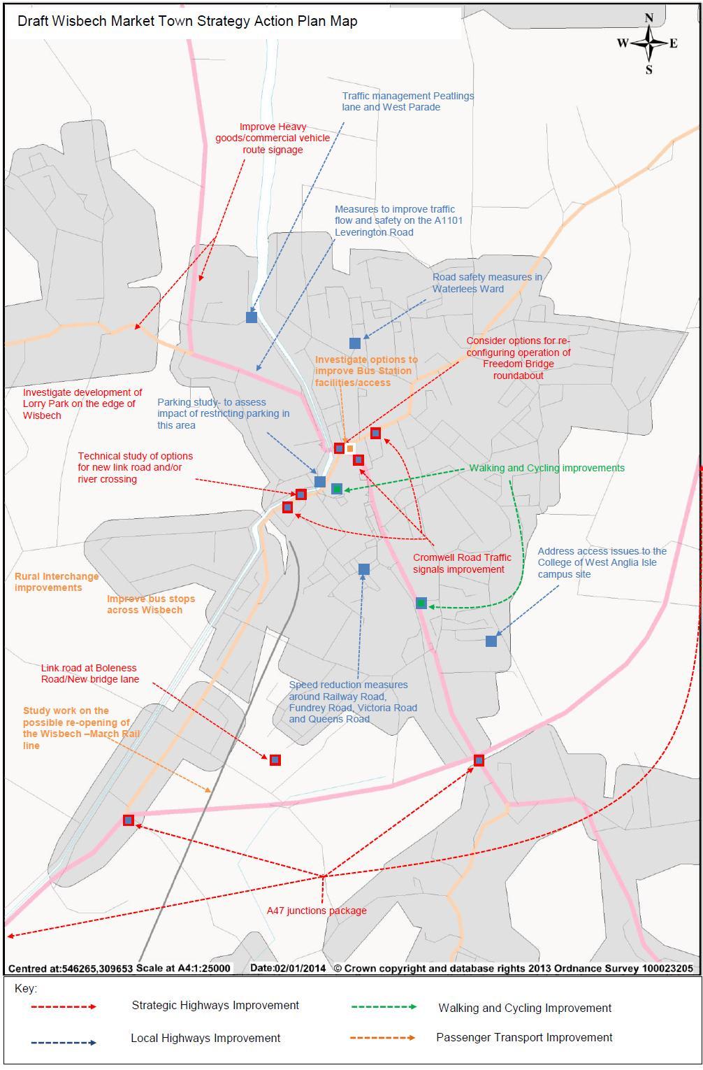
24 Although road safety issues were not highlighted by stakeholders when identifying issues for this strategy, a review of the accident data shows that there are a number of accident cluster sites in Wisbech. These cluster sites are generally on the main routes in to and out of Wisbech and at key junctions. There are a high number of slight accidents which may indicate a significant number of rear end shunt type accidents which are often prevalent in highly trafficked areas Speeding is perceived as an issue in certain locations in Wisbech. In particular the two routes (Churchill Road and Cromwell Road) from the A47 into Wisbech town centre were identified. Both of these routes have a number of traffic signal controlled junctions, which can delay journey times to or from the A47 to the town centre. As a result drivers tend to speed between sets of traffic lights to try and beat the lights and avoid having to queue at the junctions. This is an issue for road safety, but also in terms of creating an environment that is attractive in order to encourage greater levels of cycling. Speeding is also perceived as an issue on Railway Road, Queen s Road, Victoria Road and Fundrey Road as a result of new developments and rat running The public consultation on this strategy identified that a public perception of excessive speeds on roads near to schools. Cambridgeshire s Local Transport Plan 3 (LTP3) identifies approach to reducing the number of people killed or seriously injured in road traffic accidents in Cambridgeshire and indicators to monitor progress against targets. The Council will work closely with partners to promote road safety and improve education and training. This will include new and improved pedestrian crossings, speed reduction measures and training initiative for both children and adults. The Council will progress the road safety education programme and continue to implement safety schemes, including Bikeability cycle training, Walk to School Week and cycle parking at schools. Advisory 20mph signs outside of schools could also form one part of the strategy for reducing speeds in these areas. Summary of schemes in Action Plan Ref Type Scheme SH1 Strategic Highways Improvements Technical study of options for new link road and/or river crossing to the north and west of the town. SH2 Strategic Highways Upgrade Broad End Road junction with A47 Improvements SH3 Strategic Highways A47 junctions package Improvements SH4 Strategic Highways Improvements Updating Traffic modelling studies to explore options for improving movement around Freedom Bridge roundabout SH5 SH6 Strategic Highways Improvements Strategic Highways Improvements New road at Boleness Road/New bridge lane Traffic Management/signals/UTMC system Lynn Road, Churchill Road and Cromwell Road up to 23
25 SH7 SH8 LH1 LH2 LH3 LH4 LH5 LH6 LH7 LH8 Strategic Highways Improvements Strategic Highways Improvements Local highways improvements Local highways improvements Local highways improvements Local highways improvements Local highways improvements Local highways improvements Local highways improvements Local highways improvements Freedom Bridge Improve HCV route signage Feasibility study to investigate establishment of lorry parks on the edge of Wisbech Investigate measures to improve traffic flow and safety on the A1101 Leverington Road Investigate measures to improve traffic management in the residential areas of Peatlings Lane and West Parade Address access issues to the College of West Anglia Isle Campus Speed reduction measures around Railway Road, Fundrey Road, Victoria Road and Queens Road Parking study -restricting parking at peak times near junction of North Brink and Chapel Road Consider introduction of home zone type measures in Waterlees Ward specifically Bath Road/St Michaels Ave, Ollard Avenue area Investigate introduction of advisory 20mph signage near schools. Ensure County wide road safety programmes address issues in Wisbech and surrounding areas and engage fully with schools and the wider community. 24

26 7: Average vehicle speeds across Wisbech, taken from Trafficmaster GPS data from the whole month of September

27 Figure 8: Average vehicle speeds across central Wisbech, taken from Trafficmaster GPS data from the whole month of September
28 5. Traffic Modelling 5.1. The Wisbech Area Transport Study The Wisbech Area Transport Study involved the commissioning, building and testing of a traffic model. The model was then used to assess the transport implications for different scales of housing and job growth in Wisbech up to The outcomes of the testing were then used to support the Fenland District Council Local Plan and also the Borough Council of Kings Lynn and West Norfolk The traffic modelling tested the transport implications of different levels of housing and employment growth in Wisbech and on the A47. The results of all the testing including all the papers for the Wisbech Area Transport Study can be found on Fenland District Council website at: Some headline details are provided in section 5.2. The Wisbech Transport Mitigation Strategy The results of the traffic modelling showed that unless solutions to the impacts of the additional housing and jobs are addressed their impacts would be too great with increased congestion and traffic in and around Wisbech. It was therefore necessary as part of the Wisbech Area Transport Study to test possible solutions to address transport issues The Wisbech Transport Mitigation Strategy was therefore developed which includes a range of transport solutions for Wisbech and A47. The mitigation strategy measures were then tested using the traffic model to ensure that they provided transport benefits to reduce traffic impacts and congestion The following measures were tested and have been included in the final Wisbech Transport Mitigation Strategy: Freedom Bridge Roundabout changes Bus Station Access Changes Improvements to A47 Broad End Road Junction A new road at Boleness Road/Newbridge Lane (not connecting with A47) River crossing and New Link Road (Western Bypass) Improvments to A47 Guyhirn and A47 Cromwell Road roundabouts West Opportunity zone and East Opportunity zone access modelled New cycle/walking ways proposed along Cromwell Road/Weasenham lane, Elm road, Sandy lane and Elm High Road. Further details about the Wisbech Transport Mitigation Strategy can be found on Fenland District Council website as part of the Wisbech Transport mitigation Strategy: 27
29 5.2. Modelling results The results of the traffic modelling considered a range of issues and questions such as: What happens if no measures or improvements are undertaken to the transport network or the minimum is undertaken? What happens if you increase the number of houses and jobs but do not undertake any work on the transport network? What happens if you increase the number of houses and jobs and also make some improvements to the transport network (Wisbech Transport Mitigation Strategy)? The need to assessing issues like vehicle flow, delays, journey times and congestion All the traffic modelling that was undertaken showed that there were some specific hotspots on the transport network which are: A47/A141 Roundabout A47/B198 Cromwell Road Roundabout A47/A1101 Elm High Road Roundabout A1101 Leverington Road/B1169 Dowgate Road traffic signals area Town Bridge traffic signals area Freedom Bridge Roundabout B198 Lynn Road/Mount Pleasant Road traffic signals area A1101 Elm High Road/Ramnoth Road traffic signals area B198 Cromwell Road/Weasenham Lane signals area B198 Cromwell Road /Sandown Road signals area The results of the modelling demonstrated that the mitigation measures have the capability of reducing the impacts associated with the new houses and jobs. The impact of the mitigation measures showed that there were reductions in congestion, delays and journey times when compared with doing nothing or only doing minimum or minor levels of change Traffic levels and congestion change with and without new housing and jobs because people need to travel. Traffic growth is inevitable in many respects because we all need to get to places to live our daily lives, but it is dependant on matters such as fuel cost, income levels and choices about the transport used to make each journey. It therefore has to be recognised that in addition to the transport effects of new development consideration must be given to general travel patterns over time The Wisbech traffic modelling work suggests that there could be additional transport issues on the network in and around Wisbech as a result of general growth. Local solutions such as junction improvements may need to be considered in future to reduce delays and increase capacity on the network. 28
30 6. Funding and Major Schemes 6.1. Funding the schemes listed in this strategy will be sought from a number of different sources. The delivery of the Strategy and the pace of delivery will be dependent on securing funding from a range of sources. The current funding environment remains challenging, with funding from Central Government reducing significantly. In many cases, a range of funding sources will be needed to support delivery of priorities identified in the Action Plan and are expected to include some funding from the following sources : Local Transport Plan allocation (money allocated from central government for spending on relatively small scale physical improvements to local transport networks). The County Council currently secures in the order of 4/5m per annum for the whole of the County. However this is due to be top sliced to support Local Growth Fund; The Local Growth Fund Government is proposing the establishment of this fund from 2015/16 for administration by the Local Enterprise Partnership (LEP) to support priority projects which support and help drive economic growth. A significant amount of the funding is being allocated from Department for Transport Major Schemes Funding and additional sources; Developer contributions funding from development; Negotiated through S106 planning contributions to make proposals acceptable in planning terms, and mitigate the impacts of new development on the transport network; Or from Community Infrastructure levy funding where this is adopted and a levy is charged on new development towards infrastructure and services needed to support growth. This is not currently in operation in Fenland. Local Authority Funding Local authorities such as the County Council, District County or town and parish councils can contribute funding towards the delivery of transport infrastructure and services that help deliver local priorities in their areas. Grant funding from other sources - Other opportunities arise from time to time to fund transport measures, particularly where the interventions achieve wider social, environmental or economic benefits. Possible sources include European funding, funding from government departments, and funding from local stakeholders such as the Local Enterprise Partnership. 29
31 6.2 Funding Local Growth Fund Grant funding for Transport has come under increasing pressure in recent years and the Government has decided that all new additional transport funding from 2015 onwards will be delivered through the Local Growth Fund (LGF) which will be managed and administered by the Local Enterprise Partnerships (LEPs).Government is keen to ensure that LEP s are at the forefront of driving forward economic growth and are devolving responsibilities and funding to LEP s through a new 2bn per annum (Single) Local Growth Fund Much of the LGF is funding for housing, transport and skills that would have been allocated on a grant basis but now will have to be bid for on a competitive basis. In order to secure this competitive-based funding, LEP s have developed a bid, expressed as a Strategic Economic Plan (SEP) which clarifies economic growth ambitions. A key criterion for assessing eligibility for funding is to assess economic benefits The County Council has worked with the LEP to develop a Transport Programme including major schemes which best support the SEP s vision and aims and help drive economic growth. The SEP has been submitted to Government and the outcome of the 2015/16 Growth Deal negotiations is anticipated by autumn 2014, when there will be further clarity on the likely funding available and priorities. In addition to major schemes funding, funding is also being sought as a block from Local schemes (for improvement /capacity enhancement schemes under 2m) and local sustainable transport funding (to help deliver modal shift and encourage healthy sustainable alternative means of travel) 6.3 Funding - Developer contributions Since the need for many new or improved services, facilities and other infrastructure arises to meet the requirements of new developments, development proposals should consider all of the infrastructure implications of a scheme not just those on the site or its immediate vicinity When infrastructure cannot be provided within, or is not appropriate to be located on, the development site itself, developers will be expected to make a contribution to the cost to provide what is necessary to support the new development. Contributions will be in the form of planning obligations, also known as developer contributions, secured under Section 106 of the Town and Country Planning Act 1990 (as amended) In areas where Community Infrastructure Levy (CIL) is adopted and being charged, this is expected to support transport infrastructure requirements related to growth across the District. However Section 106 contributions will remain a significant source of funding payable by developers as a contribution to off-site infrastructure provision in the 30
32 district. The Council will also consider a range of other funding sources to contribute to identified infrastructure need and further details will be set out in the IDP. Contributions payable by CIL and/or S106 payments will be in addition to any normally required by a developer to any utility company, internal drainage board or other statutory authority or organisation. 6.4 Funding- Other competitive bids to Government Cambridgeshire County Council has bid to Government s Local Sustainable Transport Fund (LSTF) for 2015/16. This is following on from a successful bid for LSTF funding in 2012, which secured funding to support sustainable alternative means of travel in two key commuter corridors, the A14 and A The current 2015/16 bid has been developed as a refined version of the current LSTF programme (taking the elements that have been most successful), targeting three new locations in the county: Wisbech, and the surrounding Travel to Work Area The Cambridge Royston corridor (AKA the A10 South) The Cambridge St Neots corridor In addition, Peterborough have decided to include Whittlesey within their LSTF bid which would be productive for cross-council working and also draw more investment into the County.The locations align with the strategic growth locations being targeted by the LEP, and this LSTF bid must be tied closely to the LEP s objectives If our bid for capital funding is successful, Cambridgeshire could have resource for a five year LSTF programme (as part of the LEP s Strategic Economic Plan) and therefore, may be scope to invest in other locations over those five years. 6.5 Major schemes - A47 Improvements Following the 2013 Spending Review, the Government announced plans for the biggest ever upgrade of our strategic roads network. Government has also committed to carrying out a number of feasibility studies to tackle some of the most notorious road hot spots in the country. A feasibility study on the A47 will be undertaken as part of the Highways Agency s route-based strategy for the east of England The proposed geographic scope of the study considers the A47, from its junction with the A1 to the West of Peterborough, through to Great Yarmouth, and would include the section of the A12 from its junction with the A47 to the south-side of the Bascule Bridge in Lowestoft. The modal scope of the study will be predominantly road-based but will to consider potential local transport improvements, and the interaction between the A47 corridor and the local road network. 31
33 6.6 Major schemes - March to Wisbech Rail The Wisbech to March Railway Line, known locally as the Bramley line, was in operation for passenger services between 1847 and The line continued to be used for freight purposes until There is currently no rail service of any form operating to/from Wisbech. There has been a desire expressed over a number of years to see the railway line reopened with passenger services available direct from Wisbech One of the key drivers for wanting to see the reintroduction of the railway is development growth. Wisbech has seen growth in recent years that has led to increased volumes of traffic, and it is considered that the reopening of the railway may offer a solution to some local road transport issues, and help significantly in terms of accessibility and regeneration of the town Investigations into the case for reopening the railway between March and Wisbech have been carried out. The work to date has been divided into three separate studies Stage 1 investigated the potential patronage and revenue generated by a rail service between March and Wisbech. This Study concluded that a conventional rail service between March and Wisbech would be expected to generate net revenue of 1.07m over an appraisal period of 2016 to The light rail scenario appears the stronger performing option, due to the significantly lower operating costs and is forecast to deliver cumulative net operating revenue over the appraisal period of over 15m Stage 2 considered the capital costs of reinstating the line and providing a new station and included an outline assessment of the key benefits. This study concluded that the estimated capital costs including optimism bias of reinstatement of the line for passenger services, overhaul of the signalling and level crossings is in the range of million depending on station location and whether or not an over bridge for the A47 is included or not. These costs are an early central cost estimate with a high degree of uncertainty. The overall Benefit Cost Ratio (BCR) of the scheme is in the range of 0.99 to 1.43 excluding revenue clawback. The scenario without the A47 bridge allied to the station in Wisbech performed the strongest Stage 3 looked into the wider economic benefits that a station would bring to Wisbech and the surrounding area. The primary indirect benefits have been calculated to be 39.7m (over a 60 year appraisal period) which increase to 56.7m if a direct service could be provided between Wisbech and Cambridge. Secondary indirect benefits through further land utilisation (than already allocated in the Fenland Local Plan) due to higher economic growth with the rail service than without leads to the following benefits: 392 additional houses built over the core strategy period 32
34 39.2m of capital expenditure associated with the house building 161 additional full time employee jobs over the core strategy period 9m of additional GVA benefits per annum once all jobs come forward Analysis shows significant value is placed by residents on having access to both social and economic opportunities through the rail service. The overall value could be in the region of 19.3m m over a 60 year period Overall benefit cost ratio when the results of stage 2 and 3 studies are combined the BCR of the scheme looks to be in the range excluding revenue clawback. The scenario without the A47 bridge allied to the station in Wisbech performed the strongest The next stage is expected to involve a Level 2 (GRIP2) Feasibility study subject to securing funding to undertake this work. This work would look in more detail at the options and their relative costs and benefits, however funding is needed in order to progress this work further.updated information will be available at: sport_funding_bids_and_studies/ A key consideration of the study work that will impact several factors, including cost, is the location of the future railway station in Wisbech. The Stage 2 report looked in brief at a possible Wisbech Station Site to the North of Weasenham Lane. This strategy strongly supports the location of a future station in a location north of the A47 to increase accessibility by walking and cycling to Wisbech. 6.7 The Wisbech Access Study m has been allocated to GCGP LEP to support growth and regeneration, improve accessibility and address congestion in and around the town of Wisbech. This 1m has been allocated to the March Wisbech Rail Study work and to what is known as the Wisbech Access Strategy. Aspects to be investigated by the study include, Freedom Bridge, the bus station a new river crossing and an associated link road. 7 Links to wider strategies: Long Term Transport Strategy and Wisbech Cambridgeshire Long Term Transport Strategy (LTTS) (consultation version) This strategy identifies the major infrastructure requirements that are needed to address existing problems and capacity constraints on Cambridgeshire s transport network, and the further infrastructure that is required to cater for the transport demand associated with planned growth. 33
35 The strategy seeks an improved integrated network to enable efficient and reliable travel between key destinations across the county. As well as improvements to rail, bus, walking and cycling, a key ambition is to improve accessibility on the strategic network and address constraints on the A14, A428, A10 and A47. The Strategy supports growth in the Local Plans, and includes an Action Plan setting out key infrastructure requirements. Where available, this provides information on estimated costs, potential funding sources, responsibilities and timescales. The Action Plan is broken down into: Schemes already planned for public sector delivery in the period Schemes required to support major development in local plans Additional schemes not currently programmed, but necessary to provide new capacity or to address existing problems on the transport network Further schemes which may be required to support longer-term growth. There is recognition that major investment will be needed and that not all challenges can be addressed at the same time. Further work will be needed over time to develop and identify deliverables. As such, the Action Plan will be a living document which can be reviewed and updated regularly (please see figure 9). The LTTS contains the following schemes in the Wisbech area: Scheme / programme A47 Wisbech junction capacity improvements package. A47 / A141 Guyhirn roundabout, Guyhirn. A47 / B198 Cromwell Road roundabout, Wisbech. A47 / A1101 Elm High Road roundabout, Wisbech (scheme in Norfolk). A47 / Broad End Road, Wisbech; priority junction replaced with a roundabout (scheme in Norfolk). Wisbech river crossing and link road. A link road between the B198 South Brink / Cromwell Road and the B1169 Dowgate Road / A1101 Leverington Road, incorporating a new bridge crossing the River Nene Route to be determined. Freedom Bridge junction modifications and Wisbech bus station access. Removal or partial removal of exit on the south arm of the Freedom Bridge roundabout to Horse Fair, and providing a new signalised junction on Nene Quay for bus and car park access (dependant on redevelopment in area). 34 Delivery Indicative cost timescale M To be determined To be determined To be determined To be determined Wisbech south access road. A new access road to To be To be determined
36 provide development access to allocations to the south of Wisbech on the current alignment of Newbridge Lane, with a new priority junction linking to an extension of Boleness Road. determined Additional schemes that are not currently programmed, but that are necessary to provide new capacity or to address existing problems on the transport network Scheme / programme Locally Promoted schemes March to Wisbech rail reinstatement Reinstate March to Wisbech rail services. A shuttle service between the towns should be viable, but further work is needed to consider in more detail the case for direct services to Cambridge, and for freight services to use the line. Highways Agency road improvements A47 capacity improvements, Peterborough to Thorney bypass. Dualling of the A47 between Peterborough and the Thorney Bypass (scheme in Peterborough). A47 capacity improvements, Thorney bypass to Walton Highway. Dualling of the A47 between Thorney Bypass and Walton Highway (scheme primarily in Cambridgeshire, but with sections in Peterborough and Norfolk). Delivery timescale To be determined To be determined To be determined Indicative cost 50-75M Highway Agency funded To be determined 7.2 Wisbech 2020 Detailed proposals aimed at bringing about the wholesale regeneration of Wisbech and its surrounding area has been published. They have been drawn up to carry forward the aims of the Wisbech 2020 Vision, the ambitious project that was set in motion in April The 29-point "Action Plan" for the Vision was launched on January 29, It seeks to make Wisbech "a great place to work, a great place to live and a great place to visit". The transport related elements of the Action Plan are listed below: Longer Term actions by 2020 and beyond No. Action Why? 22 We will investigate opportunities to improve key junctions and routes around the town in line with those identified in the Market Town Transport Strategy To reduce congestion To improve bottlenecks in the transport network To remove unnecessary street clutter To enable housing and economic growth 23 We will investigate opportunities to improve To provide better access to 35
37 public transport connections within and to the town, which will link to the existing Market Town Transport Strategy and the Cambridgeshire Future Transport Project. 24 We will provide safer walking and cycling routes throughout the town (including better signposting) which will link to the existing Market Town Transport Strategy and Wisbech Area Transport Study (links to action 27) 27 We will improve brown signs in and around the town, including key routes wherever possible, to highlight existing attractions and advertise forthcoming events (also links to action 24). employment/ hospital/other services To improve access to and from the rural hinterland To reduce congestion To improve the health of local residents To promote local attractions on walking/cycling routes Improved economic vitality and business confidence Increased visitor spend/stays Raised profile of the area 8. Next Steps 8.1 This is the second Market Town Transport Strategy for Wisbech. The measures suggested in the strategy are the initial response to the transport issues that have been identified in the town and its surrounding area. 8.2 The next step of the process in formulating the strategy will be to undertake a public consultation with the residents of Wisbech, to see whether the suggested measures are appropriate, and whether there is anything that has been overlooked. The strategy can then be revised accordingly through working with the Member Steering Group, and a more comprehensive list of detailed measures can be produced. Once this process is complete, the strategy would then go before the democratic decision making processes of both the County and District Councils for formal adoption as part of Cambridgeshire s Third Local Transport Plan. 36
38 37
March Maidstone Integrated Transport Strategy Boxley Parish Council Briefing Note. Context. Author: Parish Clerk 2 March 2016
 Context. Author: Parish Clerk 2 The Draft Integrated Transport Policy (DITS) sets out a vision and objectives, and identifies a detailed programme of interventions to support the Maidstone Borough Local
9. Parking Supporting Statement
 9. Parking Supporting Statement Content 1. Setting the Scene 2. Vision 3. Parking and the Shared Priorities 4. Issues 5. Delivery Programme in the first Plan Period 2001/02 2005/06 6. Good Practice 7.
Transport Workshop Dearbhla Lawson Head of Transport & Infrastructure Policy & Funding University of the Third Age.
 Transport Workshop Dearbhla Lawson Head of Transport & Infrastructure Policy & Funding University of the Third Age 30 th March 2015 1 Presentation Overview Roles and responsibilities Snapshot of Key Challenges
2. Context. Existing framework. The context. The challenge. Transport Strategy
 Transport Strategy Providing quality connections Contents 1. Introduction 2. Context 3. Long-term direction 4. Three-year priorities 5. Strategy tree Wellington City Council July 2006 1. Introduction Wellington
The Ramsey Market Town Transport Strategy 26 th April 2010
 The Ramsey Market Town Transport Strategy 26 th April 2010 Contents INTRODUCTION 2 BACKGROUND 3 Strategy Area 4 Travel to, from and within Ramsey 5 Transport problems in the town 6 Links with other policies
Bristol City Council has produced a draft Bristol Transport Strategy document.
 Bristol Transport Strategy Summary Document Introduction Bristol City Council has produced a draft Bristol Transport Strategy document. The Strategy fills a gap in transport policy for Bristol. We have
MILTON ROAD LLF PROJECT UPDATE
 Greater Cambridge City Deal MILTON ROAD LLF PROJECT UPDATE 9 th May 2017 Project objectives Comprehensive priority for buses in both directions wherever practicable; Additional capacity for sustainable
Active Travel Strategy Dumfries and Galloway
 Active Travel Strategy Dumfries and Galloway Our Active Travel Strategy The agreed Interventions for Dumfries and Galloway Council s Local Transport Strategy includes an action to Develop an Active Travel
A1307 Haverhill to Cambridge: Approval to consult on transport improvement concepts
 Report To: Greater Cambridge City Deal Executive Board 3 March 2016 Lead Officer: Graham Hughes, Executive Director of Economy, Transport and Environment, Cambridgeshire County Council A1307 Haverhill
North West Non-Technical Summary of the Transport Assessment September 2011
 North West Non-Technical Summary of the Transport Assessment September 2011 Introduction This is a Non-Technical Summary of the findings of the Transport assessment work undertaken for the proposed North
Cambridgeshire Local Transport Plan Policies and Strategy
 Cambridgeshire Local Transport Plan 2011 2026 Policies and Strategy John Onslow Acting Executive Director of Environment Services Cambridgeshire County Council Shire Hall Castle Hill Cambridge CB3 0AP
The Chatteris Market Town Transport Strategy
 1 The Chatteris Market Town Transport Strategy Introduction The Market Town Transport Strategies form an important part of the Cambridgeshire Local Transport Plan (LTP). This document sets out the main
GD 0043/18 ACTIVE TRAVEL STRATEGY
 GD 0043/18 ACTIVE TRAVEL STRATEGY 2018-2021 May 2018 Minister s Introduction There is strong evidence that regular physical activity reduces the risk of a range of health conditions. The best way to increase
Part 3: Active travel and public transport planning in new housing developments
 1 Linking active travel and public transport to housing growth and planning Part 3: Active travel and public transport planning in new housing developments Active Travel Toolkit Slide Pack July 2017 Linking
Report to Cabinet. 18 May 2016
 Agenda Item 8 Report to Cabinet 18 May 2016 Subject: Presenting Cabinet Member: Proposed CCTV Enforcement of Traffic Contraventions in a Bus Lane (Key Decision Ref. No. HE030) Highways and Environment
Strategic Director for Environment. Enclosures Appendix A - Option drawings. Jamie Blake- Strategic Director for Environment
 Chipping Barnet Area Committee 9 July 2018 Title Report of Wards Status Urgent Key Cromer Road Request for 20mph Zone Strategic Director for Environment High Barnet Public No No Enclosures Appendix A -
University of Leeds Travel Plan
 University of Leeds Travel Plan 2015-2018 Contents 1: Introduction 1.1 What is a Travel Plan? 1.2 Why do we need one? 1.3 Sustainability Strategy 2: Overview 2.1 The bigger picture 2.2 The City scale 2.3
London Cycle Network Annual Report 2000
 London Cycle Network Annual Report 2000 A cycle network for London by 2005 A cycle network for London by 2005 The London Cycle Network will: provide local links between residential neighbourhoods, railway
Appendix N(b): Portishead Station Outline Travel Plan
: Portishead Station Outline Travel Plan") Portishead Branch Lane (MetroWest Phase 1): Environment Impact Assessment Appendix N(b): Portishead Station Outline Travel Plan Prepared for West of England Councils September 2017 1 The Square Temple
Portishead Branch Lane (MetroWest Phase 1): Environment Impact Assessment Appendix N(b): Portishead Station Outline Travel Plan Prepared for West of England Councils September 2017 1 The Square Temple
Living Streets response to the Draft London Plan
 Living Streets response to the Draft London Plan Contents Living Streets response to the Draft London Plan... 1 About Living Streets... 2 Summary... 2 Consultation response... 3 Chapter 1: Planning London
A127/A130 Fairglen Interchange Improvement Schemes. Information Leaflet February 2017
 A127/A130 Fairglen Interchange Improvement Schemes Information Leaflet February 2017 1 2 Foreword By Councillor Kevin Bentley Essex is continuing to grow as a vibrant economic hub and as a fantastic place
WEST YORKSHIRE LTP CYCLE PROSPECTUS
 WEST YORKSHIRE LTP CYCLE PROSPECTUS The West Yorkshire Ambition: To be recognised as a great place for safe cycling, inspiring more people to cycle more often. INTRODUCTION Cycling is low cost, environmentally
A future cycle route network for North Staffordshire mb/08/16 Need for a strategy. Existing cycle route network
 Need for a strategy 1. The government s aim is to double cycling levels nationally by 2025 [note 1]. This would bring significant health, environmental, economic and traffic benefits [note 2]. It is widely
LEA BRIDGE ROAD - A STREET FOR EVERYONE Public consultation document
 LEA BRIDGE ROAD - A STREET FOR EVERYONE Public consultation document TELL US Bakers Arms to Leyton Green Road (Section D, E, F) Leyton Green Road to Whipps Cross Roundabout (Section G) YOUR VIEWS www.enjoywalthamforest.co.uk
Walking and Cycling Action Plan Summary. A Catalyst for Change The Regional Transport Strategy for the west of Scotland
 Walking and Cycling Action Plan Summary A Catalyst for Change The Regional Transport Strategy for the west of Scotland 2007-2021 Strathclyde Partnership for Transport Contents Purpose...2 Issues, Constraints
Nottingham Cycle City Frequently Asked Questions
 Nottingham Cycle City Frequently Asked Questions About the scheme How much money is to be spent on cycling? And where is the money from? We have 6.1 million in Growth Fund which we will be investing directly
Technical note. 1. Introduction
 Project: A428 study - Phase 2 To: Adrian Shepherd Subject: Park & Ride site locations From: Atkins Date: Jun 3, 2016 cc: Ashley Heller 1. Introduction 1.1. Purpose of Technical Note The purpose of this
Map 1 shows the two roads, and how they fit into the public transport network in and around Cambridge.
 Milton Road and Histon Road corridors bus priority infrastructure 1. Purpose The County Council would like to understand in more detail, the options to deliver the most effective corridor-based public
Transportation Master Plan Advisory Task Force
 Transportation Master Plan Advisory Task Force Network Alternatives & Phasing Strategy February 2016 BACKGROUND Table of Contents BACKGROUND Purpose & Introduction 2 Linking the TMP to Key Council Approved
ENFIELD TOWN THE REVISED DESIGN
 TOWN THE REVISED DESIGN We re turning Enfield into a borough that encourages walking and cycling, a place that s easy for all of us to get around however we choose to travel. A greener place, with safer
Cycle traffic and the Strategic Road Network. Sandra Brown, Team Leader, Safer Roads- Design
 Cycle traffic and the Strategic Road Network Sandra Brown, Team Leader, Safer Roads- Design Highways England A Government owned Strategic Highways Company Department for Transport Road Investment Strategy
Launceston's Transport Futures. Greater travel options for the people of Launceston
 Launceston's Transport Futures Greater travel options for the people of Launceston Final Draft 13 Jan 2014 1 Page Number Executive summary 3 What is Transport Futures? 4 Vision 6 Economy, access and liveability
PERSONALISED TRAVEL PLANNING IN MIDLETON, COUNTY CORK
 PERSONALISED TRAVEL PLANNING IN MIDLETON, COUNTY CORK Elaine Brick Principal Transport Planner AECOM Abstract Smarter Travel funding was awarded to the Chartered Institute of Highways and Transportation
FAQ s Walsh Road / Ferguson Road Pilot Scheme
 FAQ s Walsh Road / Ferguson Road Pilot Scheme What is happening? Traffic calming measures are being installed as a pilot. Temporary Bollards will be installed to the east of 1 Ferguson Road and a Temporary
Cycle network linking Wolverhampton city centre and Bilston town centre with employment sites and residential areas:
 Context and Problems Corridor length 12.3 km; Population within 800m 59,922; Jobs within 800m 59,100; Unemployment 11%; Average Index of Multiple Deprivation 46; Households with no car 45%; Proportion
St Neots Market Town Transport Strategy
 St Neots Market Town Transport Strategy 9th September 2008 Contents INTRODUCTION 1 Aims of the strategy 1 BACKGROUND 2 Travel to, from and within St Neots 2 Transport issues in St Neots 3 Links with other
Chelmsford City Growth Package
 Chelmsford City Growth Package Public Consultation Document Volume 2 West Chelmsford July - August 2017 Chelmsford City Growth Package Public Consultation Document - Volume 2 - West Chelmsford Contents
Active travel and economic performance: A What Works review of evidence from cycling and walking schemes
 1 Making the economic case for active travel Active travel and economic performance: A What Works review of evidence from cycling and walking schemes Active Travel Toolkit Slide Pack July 2017 Active travel
Design Workshops Summary of all Feedback January 2017
 Histon Road Corridor Design Workshops Summary of all Feedback January 2017 CITY DEAL AND GROWTH Commitment to Growth: Government, County, City and District Emerging Local Plans: 33,000 new homes 45,000
Update June 2018 OUR 2017 PUBLIC ENGAGEMENT
 Update June 2018 Hi, Let s Get Wellington Moving (LGWM) is developing a Recommended Programme of Investment (RPI) that meets our programme objectives and supports the city s and region s growth. As part
Douglas Land Use and Transportation Strategy (DLUTS) Summary. August 2013
 Summary. August 2013") Douglas Land Use and Transportation Strategy (DLUTS) Summary August 2013 Background Douglas is a large and popular residential suburb of approximately 30,000 persons on the periphery of Cork City along
Douglas Land Use and Transportation Strategy (DLUTS) Summary August 2013 Background Douglas is a large and popular residential suburb of approximately 30,000 persons on the periphery of Cork City along
Birmingham Connected. Edmund Salt. Transportation Policy Birmingham City Council
 Birmingham Connected Edmund Salt Transportation Policy Birmingham City Council www.birmingham.gov.uk/connected Birmingham Connected the story so far Broadly following EU Guidance We ve done all of this
21.07 TRANSPORT CONNECTIVITY AND INFRASTRUCTURE
 21.07 TRANSPORT CONNECTIVITY AND INFRASTRUCTURE 21.07-1 Connectivity and Choice Transport connectivity and mode choice are critical to achieving productive, sustainable and socially just cities. Travel
Speed Limit Policy Isle of Wight Council
 APPENDIX B Speed Limit Policy Isle of Wight Council 2009 Contents Section 1 Introduction 1.1 Links with the Local Transport Plan Section 2 Speed Limits on Urban Roads and Residential Areas 2.1 20mph Limits
University of Victoria Campus Cycling Plan Terms of Reference. 1.0 Project Description
 University of Victoria Campus Cycling Plan Terms of Reference 1.0 Project Description The Campus Cycling Plan, a first for the University, will provide a comprehensive and coordinated approach to support
Active Travel Towns Funding Scheme Project Proposal. Sligo. Sligo Local Authorities
 Active Travel Towns Funding Scheme 2014-2016 Project Proposal for Sligo by Sligo Local Authorities Introduction Over the last two years, Sligo Local Authorities have implemented years 1 & 2 of their 5
ONE SIZE DOESN T FIT ALL RECONCILING OVERLAPPING TRANSPORT NETWORKS IN A CONSTRAINED URBAN ENVIRONMENT
 One Size Doesn t Fit All S Corbett, C Chenery Page 1 ONE SIZE DOESN T FIT ALL RECONCILING OVERLAPPING TRANSPORT NETWORKS IN A CONSTRAINED URBAN ENVIRONMENT Authors/Presenters: Sam Corbett, Principal Transport
ANNEX1 The investment required to achieve the Government s ambition to double cycling activity by 2025
 ANNEX1 The investment required to achieve the Government s ambition to double cycling activity by 2025 May 2016 About Sustrans Sustrans makes smarter travel choices possible, desirable and inevitable.
Infrastructure Policies
 Infrastructure Policies 1. Primary Healthcare Health facilities in Ashtead comprise, Ashtead Private Hospital, two GP surgeries at Gilbert House and St Stephens, two Dental practices, the Arch and Tudor
Devonport City Cycling Network Strategy
 Devonport City Cycling Network Strategy 2010-2013 Devonport City Cycling Network Strategy Introduction In February 2010 a draft master plan for cycleways was presented to the community. The feedback received
BELFAST RAPID TRANSIT. Ciarán de Búrca Director, Transport Projects Division Department for Regional Development
 BELFAST RAPID TRANSIT Ciarán de Búrca Director, Transport Projects Division Department for Regional Development Objectives of Belfast Rapid Transit To provide a modern, safe, efficient and high quality
Local Sustainable Transport Fund
 I II III Sustainable travel in Greater Manchester: The journey to a low carbon economy Greater Manchester has a vision of sustainable commuting at the heart of its blueprint for a low carbon economy, as
CSRM Modelling Summary Report for Cambridge and South Cambridgeshire Local Plans July 2013
 CSRM Modelling Summary Report for Cambridge and South Cambridgeshire Local Plans July 2013 Prepared by WSP Group and Atkins EXECUTIVE SUMMARY This Summary Report outlines the work undertaken by WSP Group
GETTING WHERE WE WANT TO BE
 CAMBRIDGESHIRE & peterborough GETTING WHERE WE WANT TO BE A GREEN PARTY TRANSPORT POLICY CONTENTS Our Campaign Priorities 4 Bus Franchising 6 Supporting Active Transport 8 Workplace Parking Levy 9 Tackling
City of Perth Cycle Plan 2029
 Bicycling Western Australia s response City of Perth Cycle Plan 2029 2012-2021 More People Cycling More Often ABOUT BICYCLING WESTERN AUSTRALIA Bicycling Western Australia is a community based, not-for-profit
York Scarborough Bridge Economic Appraisal Update Technical Note
 York Scarborough Bridge Economic Appraisal Update Technical Note Specification No. 1 Client name West Yorkshire Combined Authority Client reference M088 Discipline Transportation Project name CCAG2 Economics
ABERDEEN: CITY OF THE FUTURE
 ABERDEEN: CITY OF THE FUTURE A contribution towards discussions on a future transport strategy for Aberdeen and its Region Prepared by the Centre for Transport Research University of Aberdeen June 2010
Warfield Neighbourhood Plan: 4.4 Infrastructure
 Warfield Neighbourhood Plan: 4.4 Infrastructure Previously decided Policy headings: Policy WNP16 Transport Impact of Development Policy WNP17 Transport Proposals Policy WNP18 New School Buildings Policy
Phone: Ref No: 06/2018/0884
 Development Directorate Preston City Council Town Hall Lancaster Road Preston PR1 2RL FAO Ben Sandover Phone: 01772 533855 Email: david.allen@lancashire.gov.uk Ref No: 06/2018/0884 Date: 20 September 2018
Cycle Routes. Traffic Advisory Leaflet 3/95 March Introduction. Implementation. Project aims. Design
 Traffic Advisory Leaflet 3/95 March 1995 Cycle Routes Introduction The leaflet summarises the findings of the Cycle Routes Programme. This research was undertaken for the Department of Transport by the
Section 2 Strategic Alignment. Contents
 Section 2 Strategic Alignment Contents 2 Strategic Alignment... 2 2.1 General... 2 2.2 SmartGrowth Strategy and Implementation Plan... 2 2.3 Walking and Cycling Strategy... 3 2.4 Built Environment Strategy...
CUERDEN TRANSPORT PROPOSALS
 1 CUERDEN TRANSPORT PROPOSALS The transport assessment, submitted with the Cuerden development planning application, looks at access to the site and the impact on the local road network in detail. This
Rochester Area Bike Sharing Program Study
 roc bike share Rochester Area Bike Sharing Program Study Executive Summary ~ January 2015 JANUARY 2015 8484 Georgia Avenue, Suite 800 Silver Spring, MD 20910 3495 Winton Pl., Bldg E, Suite 110 Rochester,
Final Plan 20 December 2016
 Final Plan 20 December 2016 Introduction Aims of the Travel Plan How do we travel? Understanding travel behaviours? The University Master Plan and its implications Galway City sustainable transport policies
MARKHOUSE ROAD IMPROVEMENTS
 MARKHOUSE ROAD IMPROVEMENTS www.enjoywalthamforest.co.uk Waltham Forest is changing and we want you to be part of it. Thanks to a funding pot of 27million from Transport for London, we re delivering the
National Transport Awards Cambridge Park & Ride
 National Transport Awards Cambridge Park & Ride What Cambridgeshire has achieved q An award winning scheme focussed on quality. q Four sites, with a fifth site due to be built later this year. q 950,000
Community engagement guide May 2018
 Community engagement guide May 2018 Greater Wellington Regional Council (GWRC), Hutt City Council (HCC) and the New Zealand Transport Agency (NZTA) are working together to achieve some big improvements
1.5 On this basis it is fundamental that the Transport Strategy for the site focuses on the following key criteria,
 1.0 Introduction 1.1 The Transport Assessment has been prepared on behalf of Eon and Roger Bullivant Ltd in respect of the proposed mixed use sustainable urban extension of Drakelow Park. 1.2 The methodology
Our journey a 20 year Transport Manifesto for the North East
 Our journey a 20 year Transport Manifesto for the North East Sustrans submission to North East Combined Authority (NECA). March 2016 Summary Sustrans is a leading UK charity enabling people to travel by
Report to: Greater Cambridge Partnership Executive Board 4 July Transport Strategy - Future Public Transport Requirements
 Report to: Greater Cambridge Partnership Executive Board 4 July 2018 Lead officer: Peter Blake GCP Transport Director Transport Strategy - Future Public Transport Requirements 1. Purpose 1.1. This paper
Wellington Public Transport Spine Study
 Wellington Public Transport Spine Study Study purpose Feasibility study Options for a high quality, high frequency PT system Key action from Ngauranga to Airport Corridor Plan (2008) Long-term outlook
Background. Caversham a vision for the future. Joint public meeting arranged by:
 Joint public meeting arranged by: Sharing our Streets Caversham a vision for the future and Caversham Traders Association This presentation followed a presentation by Simon Beasley, Network Manager for
MILTON ROAD ~ MITCHAM'S CORNER PARAMICS MODEL INITIAL OPTION TESTING
 MILTON ROAD ~ MITCHAM'S CORNER PARAMICS MODEL INITIAL OPTION TESTING NOVEMBER 216 MILTON ROAD ~ MITCHAM'S CORNER PARAMICS MODEL INITIAL OPTION TESTING Cambridgeshire County Council Type of document (version)
AMETI PANMURE: A SUSTAINABLE TRANSPORT SOLUTION - OR NOT? Phil Harrison, Opus International Consultants
 IPWEA Conference: 7 June 11 June 2015 Abstract AMETI PANMURE: A SUSTAINABLE TRANSPORT SOLUTION - OR NOT? Phil Harrison, Opus International Consultants The AMETI project is a package of multi-modal transport
Government transport policy
 Government transport policy and the implications for planning RTPI TPS Transport Planning Network James Harris P o l i c y a n d N e t w o r k s M a n a g e r R o y a l To w n P l a n n i n g I n s t i
Chapter 7. Transportation. Transportation Road Network Plan Transit Cyclists Pedestrians Multi-Use and Equestrian Trails
 Chapter 7 Transportation Transportation Road Network Plan Transit Cyclists Pedestrians Multi-Use and Equestrian Trails 7.1 TRANSPORTATION BACKGROUND The District of Maple Ridge faces a number of unique
Climate Change Action Plan: Transportation Sector Discussion Paper: Cycling
 Climate Change Action Plan: Transportation Sector Discussion Paper: Cycling ontario.ca/climatechange Contents 1. Minister of Transportation s message... 3 2. Introduction... 5 3. Sector Overview and Support
Determining bicycle infrastructure preferences A case study of Dublin
 *Manuscript Click here to view linked References 1 Determining bicycle infrastructure preferences A case study of Dublin Brian Caulfield 1, Elaine Brick 2, Orla Thérèse McCarthy 1 1 Department of Civil,
Easton Safer Streets - Final Project Report BRISTOL
 - Final Project Report BRISTOL A Sustrans Community Street Design Project in partnership with Bristol City Council February 07 About Sustrans Sustrans makes smarter travel choices possible, desirable and
Delivering the. Strategy 7.0
 7.0 Delivering the Strategy 7.1 Introduction This chapter presents a framework for the delivery of the strategy. Key challenges and opportunities are identified that will have an impact on the successful
Regional Cycle Programme Update
 Agenda Item 10 (ii) Regional Cycle Programme Update Glossary Auckland Council Auckland Transport Cycle Action Auckland New Zealand Transport Agency Regional Cycle Network (AC) (AT) (CAA) (NZTA) (RCN) Executive
Your views are important. Please fill in a form before you leave. Or alternatively
 Drum Property Group is delighted to welcome you to this exhibition which sets out our initial proposals for a mixed-use development at Stead s Place, Edinburgh. We are keen to hear the views of local people
Welcome. Background. Goals. Vision
 Welcome The formal Public Information Centre (PIC) for the Transportation Master Plan How We GO will be held in early 2017. At that time we will present the recommended transportation system for Niagara
Developing a Birmingham Transport Space Allocation policy. David Harris Transport Policy Manager Economy Directorate Birmingham City Council
 Developing a Birmingham Transport Space Allocation policy David Harris Transport Policy Manager Economy Directorate Birmingham City Council Birmingham s Sustainable Urban Mobility Plan Birmingham Connected
Ormond & McKinnon Walks Response to Draft Glen Eira Community Plan
 Response to Draft Glen Eira Community Plan We would like to take this opportunity to thank Glen Eira City Council for the opportunity to comment on the Glen Eira Draft Community Plan. Below is an outline
Bus and Transit Lane Review Update
 Board Meeting / 25 February 2013 Agenda Item no.8(i) Bus and Transit Lane Review Update Glossary Auckland Transport New Zealand Transport Agency Transit Two Transit Three (AT) (NZTA) (T2) (T3) Executive
This objective implies that all population groups should find walking appealing, and that it is made easier for them to walk more on a daily basis.
 Walking for life The Norwegian Walking Strategy Guro Berge Norwegian public Roads Administration "Walking for life" is the slogan for the National Walking Strategy that is now being formulated in Norway.
The Cabinet Member for Highways & Streetscene. Aurang Zeb - Head of Highways & Transport
 LONDON BOROUGH OF RICHMOND UPON THAMES Cabinet Member Decision DATE: January 2012 REPORT OF: LEAD OFFICER: SUBJECT: WARDS: The Cabinet Member for Highways & Streetscene Aurang Zeb - Head of Highways &
Reflections on our learning: active travel, transport and inequalities
 Reflections on our learning: active travel, transport and inequalities Jill Muirie Glasgow Centre for Population Health Active travel definition Active travel refers to walking, cycling or using some other
Greater Cambridge City Deal. Initial consultation on better bus, cycling and walking trips. Milton Road
 Greater Cambridge City Deal Initial consultation on better bus, cycling and walking trips Milton Road Response by Kings Hedges, East and West Chesterton Labour Parties The Greater Cambridge City Deal has
EXECUTIVE SUMMARY Callan Park accommodates travel from a wide range of transport modes, including walking, cycling, bus and light rail.
 TRANSPORT AND ACCESS EXECUTIVE SUMMARY Callan Park accommodates travel from a wide range of transport modes, including walking, cycling, bus and light rail. Whilst there are some walking facilities within
Proposed. City of Grand Junction Complete Streets Policy. Exhibit 10
 Proposed City of Grand Junction Complete Streets Policy Exhibit 10 1 City of Grand Junction Complete Streets Policy Vision: The Complete Streets Vision is to develop a safe, efficient, and reliable travel
Regional Cycling Plan
 Adopted December 2008 Quality for Life Adopted December 2008 For more information, contact: Greater Wellington 142 Wakefield Street PO Box 11646 Manners Street Wellington 6142 T 04 384 5708 F 04 385 6960
Neighbourhood Development Plan: Ashtead INTRODUCTION 2 SUMMARY CONCLUSION CAR USE AND CONGESTION IN ASHTEAD 4
 CONTENTS Page INTRODUCTION 2 SUMMARY CONCLUSION 3 1.0 CAR USE AND CONGESTION IN ASHTEAD 4 1.1 Car Ownership and Methods of Travel to Work 4 1.2 Traffic Congestion in Ashtead 4 2.0 PARKING FACILITIES AND
Cycling and Walking Investment Strategy & Local Cycling and Walking Infrastructure Plans
 Cycling and Walking Investment Strategy & Local Cycling and Walking Infrastructure Plans 1 Investing in cycling and walking contributes to a broad range of cross-cutting policy objectives Cycling and walking
Greater Cambridge City Deal Executive Board & Joint Assembly
 Greater Cambridge City Deal Executive Board & Joint Assembly Welcome to the Call for Evidence on tackling congestion in Cambridge Launch Event 11 th November 2015 Bob Menzies Service Director: Strategy
Cycle City Ambition Grants
 Cycle City Ambition Grants Guidance on the Application Process is published alongside this application form on the Department s website. Please include all relevant information with your completed application
CAIRNGORMS NATIONAL PARK AUTHORITY FOR DECISION
 CAIRNGORMS NATIONAL PARK AUTHORITY FOR DECISION Title: Prepared by: A9 Dualling Project: Dalraddy to Slochd Murray Ferguson, Director of Planning and Rural Development and Gavin Miles, Head of Planning
Tel: Karime Hassan Chief Executive Exeter City Council Civic Centre Paris Street Exeter EX1 1JN
 Page 1 of 6 Karime Hassan Chief Executive Exeter City Council Civic Centre Paris Street Exeter EX1 1JN Dear Mr Hassan 14th September 2015 Re: Development of Bus & Coach Station Site Following the submission
A65 TRANSPORT ASSESSMENT. 13 th May 2005
 A65 TRANSPORT ASSESSMENT 13 th May 2005 1 CONTENTS 1.0 Introduction 2.0 Overview 3.0 Detailed Assessment of the A65 Corridor 4.0 Future Proposals 5.0 Conclusions List of Figures Figure 1: AM Average Traffic