Reversible Elevated Express Lanes. A Solution for Urban Traffic Congestion
|
|
|
- Eleanor Harrington
- 6 years ago
- Views:
Transcription

1 Lee Roy Selmon Crosstown Expressway Reversible Elevated Express Lanes A Solution for Urban Traffic Congestion Martin Stone, Ph.D., AICP Director of Planning Tampa-Hillsborough Expressway Authority
2 Pensacola Tallahassee Jacksonville Orlando Tampa Miami
3 Pensacola Tallahassee Jacksonville Orlando Tampa Miami

4 1975 Open to Downtown
5 1975 Open to Downtown 1986 Open to I-75
6 1987 Tampa Interstate Study (EIS) Masterplan I-275 & I-4: Add 1 Lane Crosstown: Add 1 lane
7 1987 Tampa Interstate Study (EIS) Masterplan I-275 & I-4: Add 1 Lane Crosstown: Add 1 lane and connect to I-4
8 Traffic growth significantly exceeded 20-yr projections 1987 Tampa Interstate Study (EIS) Masterplan I-275 & I-4: Add 1 Lane Crosstown: Add 1 lane and connect to I-4
9 Traffic growth significantly exceeded 20-yr projections Brandon suburb grew to over 200,000 Would be 4 th largest Fla city
10 Traffic growth significantly exceeded 20-yr projections Crosstown WB traffic service decreased from LOS B to LOS F during AM Peak by 1995
11 East Crosstown Traffic Characteristics 50,000 ADT 75/25 D split 15% Peak Hour 98% Repeaters Crosstown WB traffic service decreased from LOS B to LOS F during AM Peak by 1995
12 East Crosstown Traffic Characteristics Connecting I-4 to Expressway would result in LOS F for both roads within <10 years Crosstown WB traffic service decreased from LOS B to LOS F during AM Peak by 1995
13 Problems 1. Severe AM/PM Peak Traffic Congestion - Long-term Need for 10 Lanes
14 Problems 1. Severe AM/PM Peak Traffic Congestion - Long-term Need for 10 Lanes 2. Physical Considerations - Narrow ROW - Constrained
15 Problems 1. Severe AM/PM Peak Traffic Congestion - Long-term Need for 10 Lanes 2. Physical Considerations - Narrow ROW - Constrained 3. Fixed Rail Not Feasible - Population (Approx 1,000,000) - Land Use & Density Not Suitable - No Complimentary Infrastructure - Ridership NOT Large Enough to Positively Affect Traffic Congestion - No Local Capital or O&M Subsidies - BRT a More Flexible Transit Solution
16 I-4/Crosstown Solution 1. Scrapped original expansion to 6 lanes
17 I-4/Crosstown Solution 1. Scrapped original expansion to 6 lanes 2. Developed 3 reversible express lanes - Divert at least 50% of commuter traffic from existing lanes to express lanes - Use excess capacity on existing lanes to handle traffic from I-4 connection
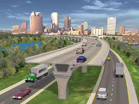
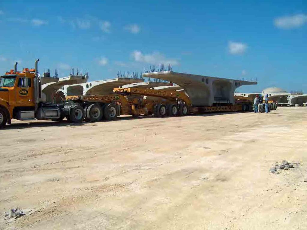
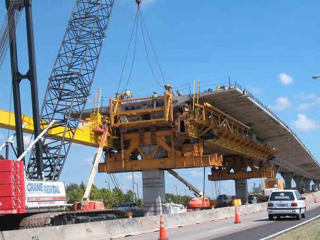
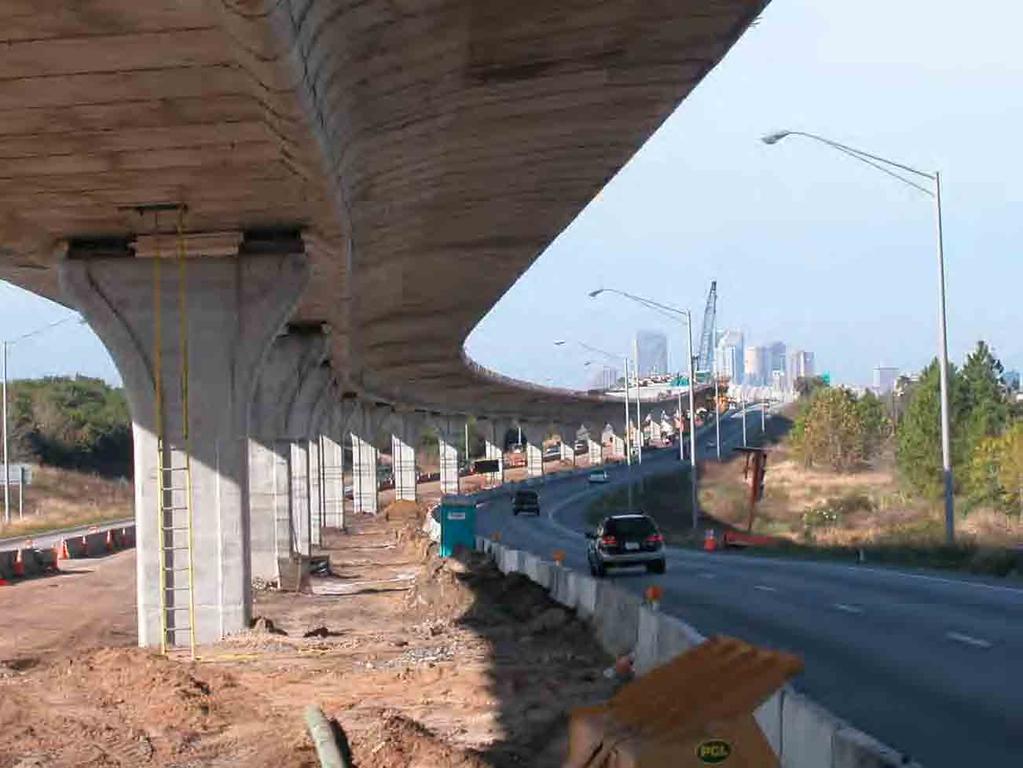
18 I-4/Crosstown Solution 1. Scrapped original expansion to 6 lanes 2. Developed 3 reversible express lanes - Divert at least 50% of commuter traffic from existing lanes to express lanes - Use excess capacity on existing lanes to handle traffic from I-4 connection 3. Build most of project as a concrete segmental bridge in the median 6 lanes on 6 feet to save valuable ROW for future transportation needs
19
20
21 Selmon Crosstown Expressway Typical Section Existing 4 Lanes
22 Selmon Crosstown Expressway Typical Section Existing 4 Lanes with 3 Express Lanes
23 Selmon Crosstown Expressway Typical Section Expand to 6 Lanes with 3 Express Lanes
24 Selmon Crosstown Expressway Typical Section Add Transit with 3 Express Lanes
25
26
27
28 Project Costs & Benefits Total Project Cost = $300 Million - Planning & Env Studies = $2M - Design = $4M - Bridge Section (6 miles) = $144M - Downtown gateway (1 mile) = $20M - At-Grade Section (3 miles) = $40M - All ITS Controls & TMC = $17M - ROW (ponds) = $5M - ROW (downtown gateway) = $28M
29 Project Costs & Benefits Transportation Benefits - Total Traffic = 115,000 ADT - East End Traffic = 75,000 ADT - LOS F in AM & PM Peak - AM Peak Trip Time = Minutes
30 Project Costs & Benefits Transportation Benefits - Total Traffic = 115,000 ADT - East End Traffic = 75,000 ADT - LOS F in AM & PM Peak - AM Peak Trip Time = Minutes With Reversible Express Lanes - 150% Increase in Capacity - Divert 10,000 Trips from Local Roads - LOS B-C for East End of Expressway - AM Peak Trip time = 10 Minutes - Four New Express Bus Routes
31 Typical New Projects Planning & Production Schedule ACTIVITIES Preliminary Planning MPO LRTP Process Environmental Study Design ROW Aquisition Construction
32 Typical Elevated New Projects Lanes Planning & Production Schedule ACTIVITIES Preliminary Planning MPO LRTP Process Environmental Study Design ROW Aquisition Construction
33 Lee Roy Selmon Crosstown Expressway Reversible Elevated Express Lanes A Solution for Urban Traffic Congestion Martin Stone, Ph.D., AICP Director of Planning Tampa-Hillsborough Expressway Authority
34

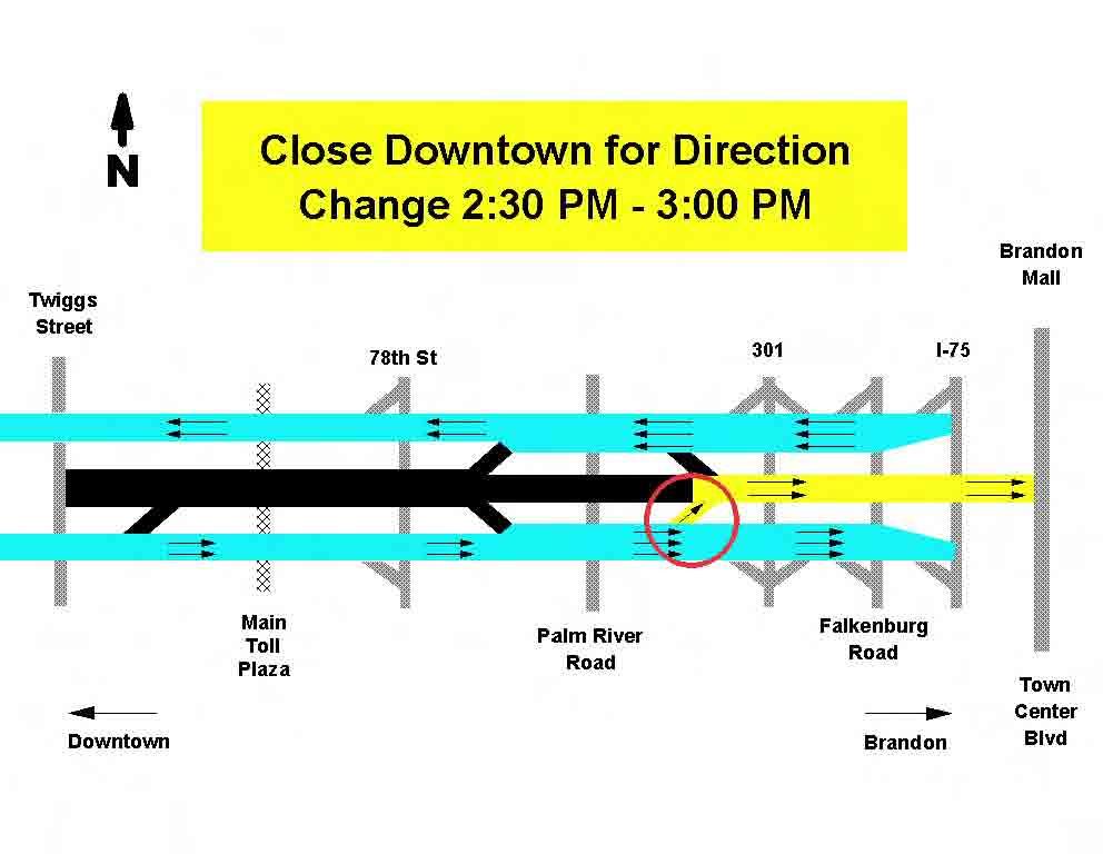
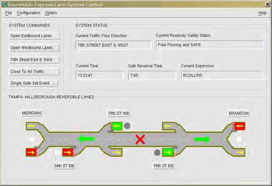
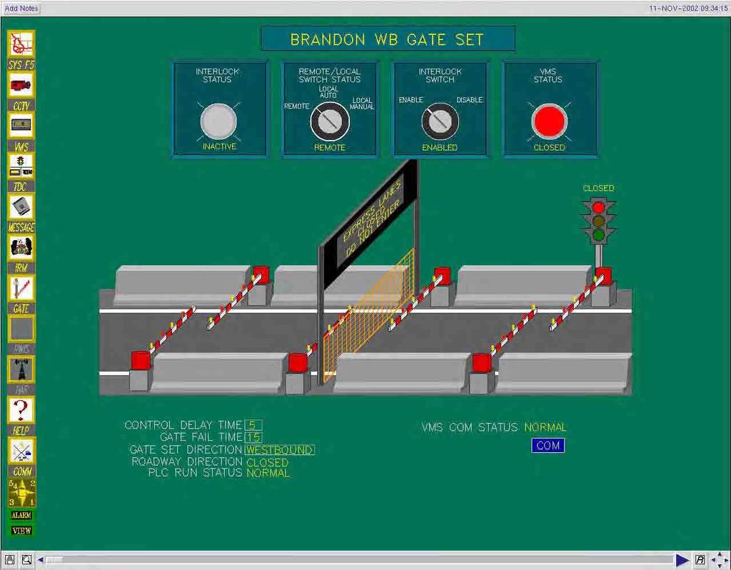
35 Intelligent Transportation System Reversible Express Lane Operations
36
37
38
39
40
41
42
43
44
45
46
47
Solution To Urban Congestion by Martin Stone, Tampa-Hillsborough Expressway Authority and Jose Rodriguez, FIGG
 The elevated roadway near Brandon uses colors reflective of the more natural environment, landscaping, and water features found in the area. Photos: FIGG Construction of the elevated roadways was within
Gandy Connector: Travel Demand. Policy Committee August 2013
 Gandy Connector: Travel Demand Policy Committee August 2013 What options to the Gandy Elevated Lanes exist? What are the current conditions? Who s using Gandy Blvd? What s currently planned? What s been
State Road 54/56 Tampa Bay s Northern Loop. The Managed Lane Solution Linking I-75 to the Suncoast Parkway
 State Road 54/56 Tampa Bay s Northern Loop The Managed Lane Solution Linking I-75 to the Suncoast Parkway SUNCOAST PARKWAY Both I 75 and the Suncoast Parkway are planning, or in the process of constructing,
Preview. Tables in your paper Mass Transit as alternative to auto California s problems in urban transportation
 Preview Tables in your paper Mass Transit as alternative to auto California s problems in urban transportation Integrating tables in your writing Commuting in Urban Areas Last time auto and congestion
MOVEABLE BARRIER. Congestion Management Solutions
 MOVEABLE BARRIER Congestion Management Solutions 1 Portland area morning congestion (AM) 2 Portland area afternoon congestion (PM) 3 30 year planning - Portland Area 100% Growth over 30 years 4 Movable
Preview. Second midterm Tables in your paper Mass Transit as alternative to auto California s problems in urban transportation
 Preview Second midterm Tables in your paper Mass Transit as alternative to auto California s problems in urban transportation Score Distribution 1 st Midterm 2 nd Midterm 3.5-4.0 8% 21% 3.0-3.5 23% 34%
DRAFT. Memo. Range of the Alternatives Considered in the EIS
 Memo Date: Friday, December 09, 2016 Project: To: From: Subject: State Route 30 EIS UDOT Vince Izzo This memorandum summarizes the draft State Route (S.R.) 30 Level 1 screening results. A more detailed
ROADSOADS CONGESTION HAMPTON SYSTEMYSTEM MANAGEMENT. Part II Roadway Congestion Analysis Mitigation Strategies and Evaluation
 HAMPTON ROADSOADS CONGESTION MANAGEMENT SYSTEMYSTEM Part II Roadway Congestion Analysis Mitigation Strategies and Evaluation Presented by: Dwight Farmer, PE Deputy Executive Director, Transportation April
JONESBORO HIGHWAY 63 HIGHWAY 18 CONNECTOR STUDY
 JONESBORO HIGHWAY 63 HIGHWAY 18 CONNECTOR STUDY Craighead County May 2007 JONESBORO HIGHWAY 63 HIGHWAY 18 CONNECTOR STUDY Craighead County May 2007 Prepared by Planning and Research Division Arkansas State
TAMPA BAY EXPRESS (TBX)
") TAMPA BAY EXPRESS (TBX) Hank Schneider, P.E. FDOT- District 7 Consultant Project Manager Florida Department of TRANSPORTATION TAMPA BAY EXPRESS AGENDA What is TBX? What does TBX do? Why is TBX Important?
TAMPA BAY EXPRESS (TBX) Hank Schneider, P.E. FDOT- District 7 Consultant Project Manager Florida Department of TRANSPORTATION TAMPA BAY EXPRESS AGENDA What is TBX? What does TBX do? Why is TBX Important?
Mobility and Congestion
 Technical Memorandum Mobility and Congestion Prepared for: Prepared by: September 25, 2013 1 Table of Contents 1. Introduction... 1 2. Congestion Forecasting Process... 1 2.1 Mobility and Congestion Terms...
APPENDIX G: INTERSECTION NEEDS AT OKEECHOBEE BOULEVARD
 APPENDIX G: INTERSECTION NEEDS AT OKEECHOBEE BOULEVARD INTERSECTION NEEDS AT SR 7 and OKEECHOBEE BOULEVARD SR 7 Extension Project Development and Environment (PD&E) Study From Okeechobee Boulevard (SR
Highway Transitway Corridor Study
 Highway Transitway Corridor Study CTS Research Conference May 21, 2014 1 2030 Transportation Policy Plan Transitway modes on highways: Highway bus rapid transit (BRT), plan identified 6 total Highway BRT
Crenshaw Transit Corridor Study. Working Group Meetings March 2009
 Crenshaw Transit Corridor Study Working Group Meetings March 2009 1 Concepts to Think About Today Alternatives and Design Options Grade Separation Analysis Supplemental Inglewood Alignment Analysis Evaluation
ROUTES 55 / 42 / 676 BUS RAPID TRANSIT LOCALLY PREFERRED ALTERNATIVE
 ROUTES 55 / 42 / 676 BUS RAPID TRANSIT LOCALLY PREFERRED ALTERNATIVE April, 2012 1 INTRODUCTION The need for transit service improvements in the Routes 42/55/676 corridor was identified during the Southern
South King County High-Capacity Transit Corridor Study
 HIGH-CAPACITY TRANSIT CORRIDOR STUDY South King County Corridor South King County High-Capacity Transit Corridor Study Corridor Report August 2014 South King County High Capacity Transit Corridor Report
A Federal Perspective on Congestion Pricing. Wayne Berman Federal Highway Administration July 8, 2010
 A Federal Perspective on Congestion Pricing Wayne Berman Federal Highway Administration July 8, 2010 Overview Background on Congestion Pricing Benefits and Experiences of Pricing Case Study Miami I-95
Corridor Advisory Group and Task Force Meeting #10. July 27, 2011
 Corridor Advisory Group and Task Force Meeting #10 July 27, 2011 1 Agenda Recap CAG/TF #9 Public Meeting #2 Summary Single Mode Alternatives Evaluation Results Next Steps 2 3 CAG/TF #9 Recap CAG /TF #9
Arnold Hinojosa
 Policy Analysis of the Mass Transit Challenges Facing Rapidly Growing Southern and Western Cities and How These Challenges Can Be Addressed Using the Model Set by Chicago Arnold Hinojosa ahinojosa@kentlaw.edu
El Camino Real Bus Rapid Transit Conceptual Engineering. Los Altos Council Workshop January 24, 2012
 El Camino Real Bus Rapid Transit Conceptual Engineering Los Altos Council Workshop January 24, 2012 Agenda Introduction Growth in the El Camino Real Corridor Benefits of BRT El Camino Real BRT Decision
2035 Plan Post-Referendum Analysis
 2035 Plan Post-Referendum Analysis June 14, 2011 Prepared For: 601 East Kennedy Boulevard Tampa, FL 33602 www.hillsboroughmpo.org Prepared By: Introduction For this memorandum, research on cost reduction
Creating the Future Bruce B Downs Blvd
 Creating the Future Bruce B Downs Blvd How things look today May not be how things look in the future. Bruce B Downs PD&E Study 2003 Construction programmed 2009, Palm Springs to Pebble Creek Tampa Rail
Bay to Bay Boulevard Complete Streets Project
 Bay to Bay Boulevard Complete Streets Project Dale Mabry Highway to Bayshore Boulevard February 08, 2018 Photo Source: Tampa Bay Times Alessandra Da Pra Meeting Format Introduction Resurfacing Information
METHODOLOGY. Signalized Intersection Average Control Delay (sec/veh)
") Chapter 5 Traffic Analysis 5.1 SUMMARY US /West 6 th Street assumes a unique role in the Lawrence Douglas County transportation system. This principal arterial street currently conveys commuter traffic
Chapter 5 Traffic Analysis 5.1 SUMMARY US /West 6 th Street assumes a unique role in the Lawrence Douglas County transportation system. This principal arterial street currently conveys commuter traffic
INFRASTRUCTURE: Using the Grid to Create a more Self-Sustaining Downtown. Studio Spring 2013
 EMERGENT FUTURES The San Diego Section of the American Society of Civil Engineers (ASCE) released a new report, the 2012 San Diego County Infrastructure Report Card. Since the last San Diego Report Card
Proposed Project I 35 from Denton to Cooke County Line
 Proposed Project I 35 from Denton to Cooke County Line The existing I 35 facility is four lanes from I 35E/I 35W to Farm to Market Road (FM) 3002. The purpose of the proposed project is to increase capacity
Project Description Form 6V
 Project Description Form 6V Basic Project Information Submitting Jurisdiction/Agency: Prince William County Project Title: Route 15 Widening: Route 55 to south of RR tracks & Construct RR Overpass Project
Route 7 Corridor Study
 Route 7 Corridor Study Executive Summary Study Area The following report analyzes a segment of the Virginia State Route 7 corridor. The corridor study area, spanning over 5 miles in length, is a multi
Presentation of Staff Draft March 18, 2013 COUNTYWIDE TRANSIT CORRIDORS FUNCTIONAL MASTER PLAN
 Presentation of Staff Draft March 18, 2013 COUNTYWIDE TRANSIT CORRIDORS FUNCTIONAL MASTER PLAN Public Outreach Fall 2011: Two community meetings/open houses Fall 2012: Three community meetings/open houses
Congestion Management/ Crash Mitigation Process A Feasibility Study on Implementing HOV, Reversible Lanes and Time-of-Day Parking Strategies
 Congestion Management/ Crash Mitigation Process A Feasibility Study on Implementing HOV, Reversible Lanes and Time-of-Day Parking Strategies Arterial Roadway HOV Lanes Arterial Roadway Reversible Lanes
EXISTING PRIORITIES FUNDED FOR CONSTRUCTION LRTP
 EXISTING PRIORITIES FUNDED FOR CONSTRUCTION Limits Description Status 1 415489 3 H1865 US HWY 301 FROM SR 674 TO BALM RD Widen 2 lanes to 6 lanes divided County / Construction Programmed 2016 2 405492
In station areas, new pedestrian links can increase network connectivity and provide direct access to stations.
 The Last Mile Planning for Pedestrians Planning around stations will put pedestrians first. Making walking to stations safe and easy is important; walking will be a part of every rapid transit Accessible
DON MILLS-EGLINTON Mobility Hub Profile
 Mobility Hub Profile Dundas Don Mills-Eglinton West-Bloor Anchor Hub Gateway Hub N MOBILITY HUBS: Places of connectivity between regional and rapid transit services, where different modes of transportation
Southbend to Prima Vista. October 30, Floresta Corridor Master Plan
 Application of a Complete Street initiative and how it might function operationally 8 8 Southbend to Prima Vista October 30, 2017 Presentation Agenda 2 Perspective and History Traffic projections, Levels
1 PROJECT DESCRIPTION PROBLEM STATEMENT PROJECT PURPOSE AND NEED Study Purpose Study Need... 4
 January 2014 Table of Contents 1 PROJECT DESCRIPTION... 1 2 PROBLEM STATEMENT... 2 3 PROJECT PURPOSE AND NEED... 3 3.1 Study Purpose... 3 3.2 Study Need... 4 4 GOALS AND OBJECTIVES... 9 4.1 Short-term
Purpose and Need. Chapter Introduction. 2.2 Project Purpose and Need Project Purpose Project Need
 Chapter 2 Purpose and Need 2.1 Introduction The El Camino Real Bus Rapid Transit (BRT) Project (Project) would make transit and other transportation improvements along a 17.6-mile segment of the El Camino
TRB Managed Lanes Conference May 22 24, 2012, Oakland, CA
 HOT LLanes and d TTransit i P f Performance TRB Managed Lanes Conference May 22 24, 2012, Oakland, CA Miami UPA Transit Results (2008 2010 Data) Miami UPA Transit Improvements 2 new routes Dade-Broward
BUS RAPID TRANSIT. A Canadian Perspective. McCormick Rankin International. John Bonsall P.Eng
 BUS RAPID TRANSIT A Canadian Perspective Why choose BRT? Because it is a practical and cost effective rapid transit solution for the most common types of land use in urban Canada Operating experience shows
Integrated Corridor Approach to Urban Transport. O.P. Agarwal World Bank Presentation at CODATU XV Addis Ababa, 25 th October 2012
 Integrated Corridor Approach to Urban Transport O.P. Agarwal World Bank Presentation at CODATU XV Addis Ababa, 25 th October 2012 What is the Integrated Corridor Approach for Urban Transport Public? Why
CITY OF COCOA BEACH 2025 COMPREHENSIVE PLAN. Section VIII Mobility Element Goals, Objectives, and Policies
 CITY OF COCOA BEACH 2025 COMPREHENSIVE PLAN Section VIII Mobility Element Goals, Objectives, and Policies Adopted August 6, 2015 by Ordinance No. 1591 VIII MOBILITY ELEMENT Table of Contents Page Number
REGIONAL PRIORITIES Presentation to the Tampa Bay Regional Collaboration Committee September 10, 2012
 WEST CENTRAL FLORIDA MPO CHAIRS COORDINATING COMMITTEE REGIONAL PRIORITIES Presentation to the Tampa Bay Regional Collaboration Committee September 10, 2012 TRANSPORTATION REGIONAL INCENTIVE PROGRAM (TRIP)
Central Avenue Corridor Study FPID Number:
 Central Avenue Corridor Study FPID Number: 437932-1-18-01 City Commission Presentation 1 March 27, 2018 Meeting Agenda 1. Introductions 2. Project Overview 3. Opportunity for Economic Development 4. Healthy
NEWMARKET CENTRE Mobility Hub Profile
 Mobility Hub Profile Dundas Newmarket West-Bloor Centre Anchor Hub Gateway Hub N MOBILITY HUBS: Places of connectivity between regional and rapid transit services, where different modes of transportation
US 1 Express Lanes Public Kick-Off Meeting
 US 1 Express Lanes Project Development & Environment (PD&E) Study Public Kick-Off Meeting September 7 & 8, 2011 Miami Dade County, Florida 1 Presentation Agenda Introduction to MDX Background to PD&E studies
ECTS Purpose & Needs. Exhibit Home-Based Work Trips Attracted to the Penn/Jeannette Area
 Exhibit 4.23 - Home-Based Work Trips Attracted to the Penn/Jeannette Area Exhibit 4.24 - Transit Use for Work Trips Attracted to the Penn/Jeannette Area Eastern Corridor Transit Study 61 Greensburg - and
DON MILLS-SHEPPARD Mobility Hub Profile
 DON MILLS-SHEPPARD Mobility Hub Profile Dundas Don Mills-Sheppard West-Bloor Anchor Hub Gateway Hub N MOBILITY HUBS: Places of connectivity between regional and rapid transit services, where different
Alternatives Public Workshop
 US 1 Express Lanes Project Development & Environment (PD&E) Study Alternatives Public Workshop August 2013 1 Today s Agenda Project Background and Overview Tier 1 Alternatives Development Tier 2 Decision-Making
Deerfield Township Hamilton Township
 EXECUTIVE SUMMARY I. Introduction The Southwest Warren County Transportation Study is focused on a 100 square mile area with numerous transportation problems that call for a multitude of solutions (see
Bus Rapid Transit ALTERNATIVES ANALYSIS. Open House
 Bus Rapid Transit ALTERNATIVES ANALYSIS Open House June 23, 2015 Open House Meeting Agenda Agenda Introductions What is BRT? Project Goals Study Tasks Next steps Discussion PVTA Bus Rapid Transit Study
Afeasibility study to evaluate bus rapid transit service in the East-West Corridor connecting major employment and activity centers between downtown
 East-West Bus Rapid Transit Feasibility Study Update and Recommended Locally Preferred Alternative (LPA) Summary City of Wauwatosa, Transportation Affairs Committee June 2016 Afeasibility study to evaluate
CONNECTED VEHICLE PILOT DEPLOYMENT PROGRAM
 CONNECTED VEHICLE PILOT DEPLOYMENT PROGRAM August 2, 2016 Presentation Concept Pilot Location Deployment Characteristics Use Cases Application Overview 2 Concept Demonstrate and measure the impact of Connected
MOBILITY WORKSHOP. Joint City Council and Transportation Commission May 5, 2014
 MOBILITY WORKSHOP Joint City Council and Transportation Commission May 5, 2014 Review of General Plan M-1 Develop world-class transit system M-3 Maintain/enhance pedestrian-oriented City M-4 Create comprehensive
An Incentive-Based Approach to Curbing Automobile Use in the Washington, DC Metropolitan Area
 An Incentive-Based Approach to Curbing Automobile Use in the Washington, DC Metropolitan Area Emily Freimuth Daniel Selden Andrew Kimmel Brendan Shera The Problem Urban Sprawl Increased Commuting from
NORTH YORK CENTRE Mobility Hub Profile
 Mobility Hub Profile Dundas North York West-Bloor Centre Anchor Hub Gateway Hub N MOBILITY HUBS: Places of connectivity between regional and rapid transit services, where different modes of transportation
Improving Mobility Without Building More Lanes
 Improving Mobility Without Building More Lanes By Mike Salisbury and Will Toor July 2017 Copyright 2017 by Southwest Energy Efficiency Project. All rights reserved. Photo: Courtesy of the Denver Post Anyone
I-25 PEL: CO Springs Denver South Connection. Presentation to Castle Rock Town Council
 I-25 PEL: CO Springs Denver South Connection Presentation to Castle Rock Town Council June 20, 2017 An Important Corridor to Colorado Links the state s two major metropolitan areas and communities between
Scottsdale Road/Rural Road Alternatives Analysis (AA) Study. Arizona ITE/IMSA Spring Conference March 7, 2012
 Study. Arizona ITE/IMSA Spring Conference March 7, 2012") Scottsdale Road/Rural Road Alternatives Analysis (AA) Study Arizona ITE/IMSA Spring Conference March 7, 2012 Study Location and Duration Primary Study Corridor (major focus of effort) Rural Road and Scottsdale
Scottsdale Road/Rural Road Alternatives Analysis (AA) Study Arizona ITE/IMSA Spring Conference March 7, 2012 Study Location and Duration Primary Study Corridor (major focus of effort) Rural Road and Scottsdale
Transit-Driven Complete Streets
 Questions: Type questions into the box at bottom of webinar panel. Panelists for today s webinar: Nimotalai Azeez, Program Associate with the National Complete Streets Coalition Rich Weaver, Director of
DUNDAS WEST-BLOOR Mobility Hub Profile
 Mobility Hub Profile Dundas West-Bloor Anchor Hub Gateway Hub N MOBILITY HUBS: Places of connectivity between regional and rapid transit services, where different modes of transportation come together
2015 Urban Mobility Scorecard. Scott Weber, Transportation Planner & Analyst James Winters, Regional Planner & Policy Analyst
 2015 Urban Mobility Scorecard Scott Weber, Transportation Planner & Analyst James Winters, Regional Planner & Policy Analyst Introduction 1. Congestion Trends 2. Compounding Problems 3. Possible Solutions
Key Findings & Corridor Highlights
 The PA 358 Corridor Greenville to I-79 The PA 358 Corridor connects the Borough of Greenville in northwest Mercer County with I-79 to the east. For much of the way it follows the Shenango and Little Shenango
North Carolina Transportation Issues
 North Carolina Transportation Issues David T. Hartgen, Ph.D., P.E. Emeritus Professor of Transportation Studies UNC Charlotte Remarks at the Shaftesbury Lecture John Locke Foundation Raleigh, North Carolina
Tulsa Metropolitan Area LONG RANGE TRANSPORTATION PLAN
 Tulsa Metropolitan Area LONG RANGE TRANSPORTATION PLAN Indian Nations Council of Governments August 2005 CONTACTING INCOG In developing the Destination 2030 Long Range Transportation Plan, INCOG s Transportation
Managed Lanes. Steve Schilke, P.E. Major Projects Unit Head District 1. Illinois Traffic Engineering and Safety Conference October 2016
 Managed Lanes Steve Schilke, P.E. Major Projects Unit Head District 1 Illinois Traffic Engineering and Safety Conference October 2016 Agenda Managed Lanes Projects I-55 (Stevenson Expressway) Express Toll
Chapter 3 BUS IMPROVEMENT CONCEPTS
 Chapter 3 BUS IMPROVEMENT CONCEPTS The purpose of this chapter is to describe potential bus improvement strategies and potential impacts or implications associated with BRT implementation within the existing
SMART 1 Public Meeting #1. February 24, 2016
 SMART 1 Public Meeting #1 February 24, 2016 Agenda Who is the SMTC? SMART 1 project overview Syracuse Metropolitan Transportation Council An Introduction: Who we are & what we do What is an MPO? A Metropolitan
Managed Lanes 2017: What They Are and How They Work. Robert W. Poole, Jr. Director of Transportation Policy Reason Foundation
 Managed Lanes 2017: What They Are and How They Work Robert W. Poole, Jr. Director of Transportation Policy Reason Foundation http://reason.org What are Managed Lanes? Lanes restricted by price or vehicle
Measuring the Distribution and Costs of Congestion. Tim Lomax Texas Transportation Institute
 Measuring the Distribution and Costs of Congestion Tim Lomax Texas Transportation Institute http://mobility.tamu.edu The Congestion Measurement Story Travel time, variations, compare to goals WHAT? WHY?
FI N A N C I A L RESOURCER S REVIEW AND UPDATE M I A M I-DADE LO N G R A N G E TRANSPORT T ATION PLAN UPDATE TO THE YE
 Appendix B: Miami-Dade LRTP Cost Feasible Projects (Fully Funded and Partially Funded Projects) Fully Funded Projects Existing County roads O&M $317.9 $316.7 $811.5 Non Motorized set aside $27.9 $24.7
Let s Make I-40 Better Action Team. Friday, March 29, 2019 Hosted by RTP Foundation
 Let s Make I-40 Better Action Team Friday, March 29, 2019 Hosted by RTP Foundation RTA Welcome Geoff Lang, MetLife, RTA Chair Jim Beley, The Umstead Hotel & Spa, RTA regional travel experience chair NCDOT
FROM HIGHWAYS TO BOULEVARDS: STREET TRANSFORMATIONS FOR PUBLIC LIFE BONAVENTURE PROJECT
 FROM HIGHWAYS TO BOULEVARDS: STREET TRANSFORMATIONS FOR PUBLIC LIFE BONAVENTURE PROJECT By Simon Pouliot, Urban designer - City of Montreal Designing Cities 2018: Los Angeles / NACTO October 3 rd, 2018
I-35W Solutions Alliance Project Update July 13, 2017
 Title I-35W Solutions Alliance Project Update July 13, 2017 Evaluating the potential for Bus Rapid Transit and MnPASS Express Lanes in the southwest Metro, Investigating options for improved bus service
Operational Comparison of Transit Signal Priority Strategies
 Operational Comparison of Transit Signal Priority Strategies Revision Submitted on: November, 0 Author: Adriana Rodriguez, E.I Assistant Engineer Parsons Brinckerhoff 0 South Orange Avenue, Suite 00 Orlando,
ITS-NY ANNUAL MEETING Bus Rapid Transit in New York City: Bus Lane Operations on One-Way Arterial Streets
 ITS-NY ANNUAL MEETING Bus Rapid Transit in New York City: Bus Lane Operations on One-Way Arterial Streets June 9, 2011 Ted Orosz AICP, Director Long Range Bus Planning MTA New York City Transit 1 Overview
Ujari Mohite. Vijay Mahal and Vincent Sanders. Revised Ridership Forecasts for the Uptown DBL project. Date: August 17, 2015 INTRODUCTION/SUMMARY:
 To: From: Subject: Ujari Mohite Vijay Mahal and Vincent Sanders Revised Ridership Forecasts for the Uptown DBL project Date: August 17, 2015 INTRODUCTION/SUMMARY: This memorandum presents updated ridership
Dumbarton Transportation Corridor Study. San Francisco Bay ITE November 2016
 Dumbarton Transportation Corridor Study San Francisco Bay ITE November 2016 Dumbarton Corridor Source: Wikipedia 2 Dumbarton Corridor 3 Growth Imbalance Jobs-housing imbalance Major employers driving growth
Downtown BRT Corridor Alternatives Review: 1 st, 2 nd, 3 rd and 4 th Avenue. Bus Rapid and Conventional Transit Planning and Design Services
 Downtown BRT Corridor Alternatives Review: 1 st, 2 nd, 3 rd and 4 th Avenue Bus Rapid and Conventional Transit Planning and Design Services City of Saskatoon February 2018 Project Team HDR Corporation
6/14/2013. Welcome. to the US 75 Corridor Study. Public Meeting. US 75 Corridor Study Area
 Welcome to the US 75 Corridor Study Public Meeting US 75 Corridor Study Area 1 Existing and Future Congestion Levels 2012 2035 A do-nothing approach does not address the severe congestion in the region
APPENDIXB. Traffic Operations Technical Memorandum
 APPENDIXB Traffic Operations Technical Memorandum Environmental Assessment - Lincoln County, SD 85 th Street: Sundowner Avenue to Louise Avenue November 2017 MEMORANDUM Transportation Jim Kollbaum, PE
Bus Rapid Transit Plans
 Twin Cities Region Bus Rapid Transit Plans ULI Minnesota Workshop Connecting Bus Rapid Transit to the Community December 15, 2009 John Levin Director of Service Development Metro Transit Metropolitan Area
Feasibility Study for Intermodal Facility in Anchorage, Alaska
 Feasibility Study for Intermodal Facility in Anchorage, Alaska Jeanne Bowie, Randy Kinney Abstract The Dimond Transit Center, operated by People Mover, is located in south Anchorage at the Dimond Center,
WHAT IFS: Over the course of
 WHAT IFS: Over the course of the 422plus Project certain questions have arisen multiple times at meetings, briefings and on-line at the website. Most of these questions start with WHAT IF. WHAT IF vehicle
For Immediate Release September 14, 2015 Contact: Sue Chrzan Tampa Hillsborough Expressway Authority ext.
 For Immediate Release September 14, 2015 Contact: Sue Chrzan Tampa Hillsborough Expressway Authority sue@tampa-xway.com 813-272-6740 ext.130 (office) U.S. Transportation Under-Secretary Peter Rogoff and
Konstantin Glukhenkiy Economic Affairs Officer
 Konstantin Glukhenkiy Economic Affairs Officer Rapid growth of urban areas Very rapid increase in motorisation Substantial increases in traffic congestion Relative decline of public transport usage and
Overview. Illinois Bike Summit IDOT Complete Streets Policy Presentation. What is a Complete Street? And why build them? And why build them?
 Overview Illinois Bike Summit IDOT Complete Streets Policy Presentation Aren Kriks, P.E. District One Bicycle Coordinator and Bureau of Programming Project Engineer History of Complete Streets IDOT Policy
Transportation Knowledge
 FE REVIEW COURSE SPRING 2017 Transportation Engineering 4/26/2017 Transportation Knowledge 8-12 problems Traffic safety Traffic capacity Traffic flow theory Traffic control devices Transportation planning
Metropolitan Council Transportation Committee
 Nicollet-Central Transit Alternatives Metropolitan Council Transportation Committee August 2013 Project Purpose (approved by Policy Advisory Committee 10/25/2012) The purpose is to improve transit connectivity,
Figure 1: Vicinity Map of the Study Area
 ARIZONA TEXAS NEW MEXICO OKLAHOMA May 5, 2016 Mr. Anthony Beach, P.E. BSP Engineers 4800 Lakewood Drive, Suite 4 Waco, Texas 76710 Re: Intersection and Access Analysis along Business 190 in Copperas Cove
BEAR CREEK PARK AND RIDE
 BEAR CREEK PARK AND RIDE 7760 178th Pl NE, Redmond, WA 98052 700 Average weekday transit boardings 283 Parking spaces Owned by King County Metro Served by Sound Transit and King County Metro Bear Creek
VIRGINIA RAILWAY EXPRESS
 PREPARING FOR THE NEXT QUARTER-CENTURY Arlington County Board Work Session June 28, 2017 1 TODAY S PRESENTATION VRE Overview VRE in Arlington County VRE System 2040 Plan Future Vision for Crystal City
MOUNTAIN HOUSE SPECIFIC PLAN I 9.1 INTRODUCTION ASSUMPTIONS TRANSPORTATION FACILITIES TRANSPORTATION IMPROVEMENTS PHASING 9.
 CHAPTER NINE: TRANSPORTATION AND CIRCULATION 9.1 INTRODUCTION 9.1 9.2 ASSUMPTIONS 9.1 9.3 TRANSPORTATION FACILITIES 9.1 9.4 TRANSPORTATION IMPROVEMENTS PHASING 9.3 LIST OF FIGURES LIST OF TABLES Figure
Palm Beach MPO Complete Streets Policy
 Palm Beach MPO Complete Streets Policy Citizens Advisory Committee March 2, 2016 www.palmbeachmpo.org 2300 North Jog Road 4 th Floor West Palm Beach, FL 33411 561-684-4170 What are Complete Streets? Complete
Introduction. Project Need
 Introduction The purpose of Subtask 1 of the SR 54/56 Project Concept Development (PCD) Study is to identify and summarize the goals and proposed operations for transit corridor improvements as depicted
Title. Metropolitan Council Transportation Committee December 12, Brad Larson Metro District MnDOT
 Title Metropolitan Council Transportation Committee December 12, 2016 Evaluating the potential for Bus Rapid Transit and MnPASS Express Lanes in the southwest Metro Brad Larson Metro District MnDOT Background
State of the System Report. Agenda. Trends Summary. Corridor Analysis. Safety Analysis
 2017 State of the System Report SPACE COAST TRASPORTATIO PLAIG ORGAIZATIO TAC/CAC September 10, 2018 TPO Board September 13, 2018 Agenda s Summary Corridor Analysis Traffic Volumes and Congestion Evacuation
Model Applications for Oakland Park Boulevard Transit Corridor Study
 Model Applications for Oakland Park Boulevard Transit Corridor Study Southeast Florida FSUTMS Users Group June 13, 2014 Vikas Jain, AICP, GISP FDOT District Four Auditorium 3400 West Commercial Boulevard,
David Jickling, Public Transportation Director Regional Transportation Commission, Washoe County
 David Jickling, Public Transportation Director Regional Transportation Commission, Washoe County Virginia Street Resort corridor connecting University of Nevada, Reno Downtown Truckee River Strip Casinos
Pensacola Beach. BOARD OF COUNTY COMMISSIONERS Special Meeting
 Pensacola Beach Congestion Management Plan BOARD OF COUNTY COMMISSIONERS Special Meeting Board Chambers Suite 100 Ernie Lee Magaha Government Building - First Floor 221 Palafox Place http://www.myescambia.com/pensacola-beach/congestion-management-plan
Development of Arlington County s Marked Crosswalk Guidelines. Jon Lawler, P.E. Design Engineer Arlington County, VA
 Development of Arlington County s Marked Crosswalk Guidelines Jon Lawler, P.E. Design Engineer Arlington County, VA April 13, 2015 Transportation System Users Residents Estimated 215,000 in 2014 Lowest
Base Information. 1. Project Title SH7/East Arapahoe Multi-Use Path and Transit Stop Improvements. 2. Project Start/End points or Geographic Area
 Part 1 Base Information 1. Project Title SH7/East Arapahoe Multi-Use Path and Transit Stop Improvements 2. Project Start/End points or Geographic Area 38 th /Marine streets to Cherryvale Road (See attached