Snelling Avenue Multi-Modal Transportation Plan
|
|
|
- Leo Burke
- 6 years ago
- Views:
Transcription

1 Snelling Avenue Multi-Modal Transportation Plan Design Workshop Summary July 10-11, 2012 (Technical Memorandum #2)

2 Note: The material contained in this presentation is a summary of the 2-day workshop. It should not be considered to represent final decisions. This is the starting point for further refinement and analysis.

3 Plan Status Existing Conditions Phase Complete Report: June 29 th First Open House: June 12 th Concept Phase Underway Design Workshop July 10 th and 11 th
4 Purpose of the Design Workshop Provide an opportunity for the design team, agency partners and stakeholders to: Assimilate site information and existing conditions Identify programmatic needs of the corridor Refine project vision Explore range of solutions Recommend potential alternatives for further refinement and consideration


5 Desired Outcomes Identify low-cost, high-benefit options Identify near-term and long-term (25-year) solutions Overall goal Improve connections and safety
6 Design Workshop Schedule 8am- 10am 10am- 12pm 12pm- 1pm 1pm- 3pm 3pm- 4pm 4pm- 5:30pm Tuesday, July 10 th Core Team TAC Meeting Lunch Task Force Meeting Core Team Wednesday, July 11 th Core Team TAC Members Welcome Lunch Core Team Task Force Members Welcome
7 DAY ONE TAC & TASK FORCE MEETINGS
8 Initial Design Assumptions TAC Day One Based upon meetings with agency partners and community stakeholders, initial design assumptions were made to provide a start point from which to develop concepts prior to the design workshop.
9 TAC Meeting Agenda TAC Day One Introductions/purpose What has been completed so far Initial design assumptions Bike facility options Bike lane w/buffer Bike lane Cycle track (1- or 2-way) Bike boulevard options Policy and operational considerations Day Two activities/next steps
10 Initial Design Assumptions TAC Day One 11' Through lanes 10' Right turn lanes/left turn lanes 1' Left side curb reaction 2' Outside through lane curb reaction 1' Right turn lane curb reaction 11' Bus pullout 3' Bicycle buffer with 5' Bike lane 8' Parking lane 4 Reaction to median barrier, 45mph or greater 2 Reaction to median barrier, less than 45mph Proposed reduction to Zone 5 speed limit to design speed, 40mph Auxiliary lanes and shoulders in Zone 5 may be repurposed
11 Feedback on Sidewalk Assumptions TAC Day One Minimum widths established by context zone Issues include condition, width and obstructions MnDOT sidewalk design guidance 6-8 feet for circulation 3-6 feet for buffer (furnishing zone, boulevard, etc). Transit shelters + pedestrians + bicyclists require more space than exists on some sidewalks New right of way (ROW) lines could be established in the future with new development, setbacks could be required Where sidewalk width is restricted is where its most important to get bikes off of the sidewalk and on the road Preference to design widths to demand, not to only ADA compliance
12 Feedback on Transit Assumptions TAC Day One Desired transit shelter dimensions: 2 loading, 6-8 shelter, 6-8 pedestrian circulation. Rapid Bus Service Far side stops at curb extensions, 80 in length 6 per hour Stops at Como, Hewitt, Minnehaha, University and Concordia Local Service At existing and rapid bus stops 2 per hour Bus pullouts Width of 8 acceptable for pullout length needed to cross buffered bike lanes to get to curb Not preferred by Metro Transit for Rapid Bus
13 Feedback on Roadway Assumptions TAC Day One Basic ground rules from MnDOT A minimum of 2 lanes each direction will remain Assume ROW will not change ADA compliance is a given Bike lane width: 6-feet without buffer In accordance with the Flexible Design Memo in process from MnDOT, flexibility is requested, perhaps within speed and volume context Zone 5 Freight movements between ramps provide safety conflicts to cyclists Freight is concerned about repurposing or eliminating he auxiliary lanes Consider plans and geometry beyond project limits
14 Bike Facility Options TAC Day One Purpose: Preliminary concept development was conducted prior to the design workshop to identify the implications of adding the following to Snelling Avenue generally without impacting existing median or curb (i.e. a re-striping near term condition): Buffered bike lanes Conventional bike lanes Cycle track Photos and descriptions of the different types of bicycle facilities were presented


15 TAC Day One Buffered Bike Lane Description Typically include a 5-6 conventional bike lane plus 2-4 striped buffer between the bike lane and the motor vehicle travel lane Sometimes a buffer is also provided between the bike lane and parked vehicles providing space for opening car doors
 without impacts to the number of motor vehicle lanes, parking, median or sidewalks.")
16 Buffered Bike Lane Option The aerial layout indicates in heavy red highlight where the buffered bike lane would not fit within the corridor (based on initial design assumptions) without impacts to the number of motor vehicle lanes, parking, median or sidewalks. This occurs primarily in the more urban context zones (Zones 1, 3 and 4).


17 TAC Day One Conventional Bike Lane Description Typically 5-6 wide Color pavement or skip striping can be used to designate conflict zones where bicyclists and motorists cross paths such as right turn lanes
18 Conventional Bike Lane Option A layout was prepared to learn the impacts of a conventional 5 bike lane because Context Zones 1, 3 and 4 could not accommodate a buffered bike lane without impacts to the number of motor vehicle lanes, parking, median or sidewalks. While there are more areas that provide room for a conventional bike lane than a buffered bike lane, there are not continuous areas within Context Zones 1, 3 and 4 without impact to the number of motor vehicle lanes, parking, median or sidewalks.
19 Questions/Comments Regarding Bike Lane Options TAC Day One Only Type A bicyclists will use a bike lane on Snelling Use will depend on the motor vehicle speeds The bike lane is a buffer for pedestrians if the parking goes away, though parked cars might provide a more consistent buffer than through bicyclists Concern if parking were considered for removal to provide bike lanes that community would be opposed. Concern if parking were removed to provide bike lanes the speeds might increase with lack of constant presence along street while through bikes would be an intermittent presence.
20 TAC Day One Cycle Track Description A bike lane that is separated from traffic by bollards, planters or curbs stops It may be twoway on one side of the street or one-way with lanes on each side of the street
21 Cycle Track Option TAC Day One It may be possible to fit a two-way cycle track in Context Zone 5, from Taylor to Midway Parkway It would require shifting the existing centerline or repurposing the auxiliary and shoulder lanes Crossing the ramp intersections is a particular challenge for a two-way facility on one side of the street Field data show more bicyclists appear to be using the east side of street, rather than the west side.
22 Questions/Comments Regarding the Cycle Tracks Option TAC Day One Could the cycle track be a multi-use trail for both bicycles and pedestrians? The team also needs to look at bike lanes on both sides of Snelling
23 Parallel Routes Bike Boulevard Description TAC Day One Bicycle boulevards are low volume, low speed residential streets where improvements have been made to give bicyclists some priority for travel These streets are suitable for all types of bicyclists They are sometimes used as an alternate or to supplement to routes on higher volume and higher speed streets
24 TAC Day One Parallel Routes Bike Boulevard Option A map was presented showing potential routes for parallel routes/bike boulevards (next slide) Feedback at the public open house indicated these routes as preferred alternatives to Snelling Avenue Identified routes included: Aldine and Fry west of Snelling Pascal east of Snelling Each route provides crossings over I-94 and terminates at Hewitt on the north end Each route has issues with south end connections Consider both a bike lane along Snelling and a parallel bike boulevard route(s)
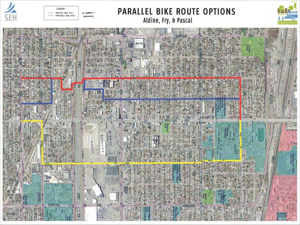
25
26 TAC Day One Other Comments Received During the Review of Bike Facility Options Parking Is parking controlled by the city or the state? How much does on-street parking impact bikes (only onequarter of available parking is used today) Was a parking utilization study done? Parking provides a buffer for pedestrians Parking is located where the sidewalks are the narrowest could widen the sidewalks if there was no parking Parking is useful to the small businesses along Snelling Retail space is under-utilized; don t want to further impact this A discussion of trade-offs is warranted Pedestrians may need more space What are the modal priorities? Bikes have other options; pedestrians do not
27 Other Comments Received During the Review of Bike Options TAC Day One Eliminating SB Left turns onto Taylor allows easier pedestrian access Hamline University would accept eliminating on-street parking near the stadium; would like to see speeds reduced on Taylor The sidewalk on the bridge needs to be widened it is only 4 feet in some areas and needs to meet ADA requirements and comfort/demand Would there be any issues on bridge loading if traffic was shifted? Would there be any behavioral issues that would need to be addressed where transitioning from one type of bike lane to another? What are the grades in Zone 5? Are there grade limits for bicyclists? Is a cantilevered pedestrian walkway on the side of the bridge an option?
28 TAC Day One Policy Considerations for Concept Development Crosswalk policy for corridor where, type, material Signals Unsignalized Snelling Ave Unsignalized side street Lighting considerations Corner radii Free right turns, signalization & geometry Right turn on red and restriction of left turns Stop control approaches to bridge sections in Energy Park area Pedestrian Hybrid Beacon (HAWK signal) Flashing Yellow Arrow: protected/permissive left turns vs. protected left turns (overall & time of day)
29 Comments Crosswalk Policy TAC Day One Crosswalks are City maintained Concern from MnDOT related to marking crosswalks at unsignalized intersections May require additional elements for safety McCalester College set the bar to a certain degree Clay pavers for crosswalks didn t work on Lexington south of 94, they were replaced with stamped concrete that fell out, and international crosswalk is in place now Pedestrian scaled lighting. Look to University Avenue to see what is desirable, twin lanterns. LED is on the way HAWK consult MnDOT traffic
30 TAC Day One Comments Related to Complete Streets Complete streets policy for Saint Paul New consultant just undertaking MnDOT will acknowledge and respect city policy More aggressive pedestrian environment is anticipated State has had complete streets policy underway longer but is further behind Corridor is operated and maintained by city
31 Comments Related to Curb Radii TAC Day One Bus transit has the following turns on and off of Snelling: SB/WB at Marshall SB/WB at University WB/NB at Energy Park There are no intersections where truck turning movements are a concern they are typically through traffic

32 DAY ONE TASK FORCE MEETING
33 Task Force Day 1 Task Force Meeting Agenda Introductions/purpose What has been completed so far Initial design assumptions Bike lane options Bike lane w/buffer Bike lane Cycle track (1- or 2-way) Bike boulevard options Snelling avenue priority crossing locations Wed s activities/next steps
34 Task Force Day 1 Comments Design Assumptions The City recommends residents to use neighborhood streets rather than Snelling Look for parcel by parcel redevelopment opportunities for additional right of way gained through setback requirements Como Avenue bridge is a tight fit for bicyclists (there is only a 4 shoulder) Pedestrian refuge islands/medians are a valued resource in the north and should be considered in the south end of the project area
35 Task Force Day 1 Comments Design Assumptions Curb extensions will not achieve speed reduction Local bus service will hold up traffic longer without bus pullouts.
36 Task Force Day 1 Comments Related to Tradeoffs Losing pedestrian space for bicycle alternatives is not preferable Type A cyclists will take the bike lane but B and C riders will take a parallel route Bike boulevards are not a substitute for bike facilities on Snelling Provide more bike parking Prioritize facilities according to vulnerability (pedestrians/people with disabilities, bikes, drivers, and parking)
37 Task Force Day 1 Comments Tradeoffs Hamline University representative comments Reduction of traffic on Taylor is desirable (reduced access at Snelling would be acceptable) Loss of Snelling Ave parking south of Taylor is acceptable Green medians for traffic calming but may not fit to accommodate facilities for bicycles and pedestrians
38 Task Force Day 1 Comments Pedestrians The team described that the short term improvements focused on the curb to curb with ADA corrections a priority The team described that the long term improvements will recommend changes in between building faces and may also recommend some zoning and land use study, or the leveraging of redevelopment The nature of the today s agenda didn t focus on pedestrian aesthetics or sidewalk widening Will the study recommend sidewalk widths? Is the study looking at building face to building face or curb to curb? Although ADA compliance is a given for the study, there is a desire to go further: Incorporate complete streets work Enhance pedestrian facilities aesthetics Saw joints are preferred for sidewalks for surface smoothness
39 Task Force Day 1 Comments Pedestrians Concrete crosswalks preferred to reduce rutting/grooving from vehicles Marked crosswalks desirable Pedestrian facility continuity and amenities are a priority for MnDOT Consider colored concrete at crosswalks for visually impaired Consider redevelopment setbacks of 4 to add width to sidewalk width as done for University Avenue A zoning study would be helpful if this project made redevelopment a possibility Use auto parking spaces for bicycle parking and shared parking practices within lots. Hamline University is working with Xcel to get Utility poles in the sidewalk near the Hamline Stadium relocated
40 Task Force Day 1 Comments NW Quadrant Study Study did not show reduction of truck traffic south of Pierce Butler Desire for improved truck movement from Pierce Butler to Energy Park O/D data on truck traffic would be informative State Statutes designate Snelling Avenue a truck route. MnDOT does not foresee this changing.
41 Task Force Day 1 Comments General Increase coordination among groups and ongoing study Provide links to other studies including: NW Quadrant Study TLC Road Safety Audit Green Streets Report Saint Paul Complete Streets Plan Active Living Ramsey County efforts Sierra Club efforts Project team does have understanding of these studies and findings
42 Task Force Day 1 Bike Facility Options The preliminary concepts for bicycle facilities that were presented at the morning TAC meeting were also shared with the Task Force: Buffered bike lanes Conventional bike lanes Cycle track Photos and descriptions of the different types of bicycle facilities were presented
43 Task Force Day 1 Buffered Bike Lane Conventional Bike Lane
44 Task Force Day 1 Comments Bike Lane Options May bus pullouts be used for bike lanes? How do buffered bike lanes work with rapid bus? No consideration has been made for widening the sidewalks

45 Task Force Day 1 Cycle Track and Parallel Route Options Cycle Track Concept -Minnehaha to Midway Parkway Parallel Route Options Aldine, Fry, Pascal
46 Task Force Day 1 Comments Bike Boulevard Options Aldine and Pascal are far away from Snelling, is Simpson an option? Redevelopment of the Midway Shopping Center would help to re-establish the street grid and be helpful to bicyclists Pascal Busy but good cycling street Challenges University to Sherburne Connects to many land uses Parallel routes should compliment, not substitute for, major routes such as Snelling


47 Snelling Avenue Priority Crossing Locations Priority crossings along the corridor were identified using the following data: Pedestrian/Bike Volume Nearby trip attractors Transit stops Bike lanes Bike/Ped collisions Motor vehicle collisions Crossing length
48 Task Force Day 1 Comments Priority Crossing Locations The preliminary list of St. Anthony, Spruce Tree, University, and Hewitt is acceptable The following locations should also be carefully considered: Charles (due to current Charles bike facility study) Thomas (due to bike friendliness) Minnehaha (neighborhood hub, bike route) Englewood (First Hamline building with Snelling Frontage under construction here) Hubbard (high use and crossings with elementary school) Taylor (a gateway possibility) Midway (due to state fair and event parking)
49 Task Force Day 1 Comments Priority Crossing Locations Spruce Tree Signal is too close to Snelling can it be taken out? Provides access to shopping center Lots of pedestrians at this intersection Hewitt elementary students cross here and at Minnehaha

50 DAY TWO CORRIDOR VISION (BY MODE) REVISED DESIGN ASSUMPTIONS VISION TYPICAL SECTIONS CORRIDOR LONG-TERM CORRIDOR NEAR-TERM
51 Corridor Vision If Snelling Avenue were built today, how would we like to see it designed? The design team and TAC members asked ourselves this question during the morning of Day 2. The group brainstormed a Corridor Vision for Snelling Avenue that sought to balance the many functions of the street with the varied contexts of the neighborhoods through which it travels. We assumed the street would serve the same multi modal mix it serves today. The Corridor Vision set the stage for our concept development, refinement and analysis moving forward.
52 Corridor Vision The Vision elements were discussed with the Task Force in the afternoon of Day 2 Task Force comments to the Corridor Vision are shown on the following slides in brown text.

53 Corridor Vision Urban Street Lower speeds mph south of Taylor (or Como) mph north of Taylor (or Como) No freeway style ramps Except at I-94 Signalize the intersections in Context Zone 5 Four motor vehicle thru lanes Limited turn lanes Only where really needed Especially north of University Consistent speed and flow of traffic Seamless for all modes Rapid Bus presence Task Force Comments in Brown
54 Corridor Vision Character of Street Green Corridor Trees, plantings, innovative storm water management Streetscaping/Landscaping Furnishings, benches, etc. Pedestrian-scale lighting On sidewalks Beautiful Vitality People, community/neighborhood connections, economic development, property maintenance, small businesses Well maintained, no trash Especially at bus stops, recycling Task Force Comments in Brown

55 Corridor Vision Sidewalks Minimum 10 (building front to face of curb) Clear walk zone minimum 6 Expand sidewalk width for: High pedestrian activity Transit stops Clear furnishing zone at transit stops Wider than 10 on bridges ADA-compliant Streetscaping/landscaping/lighting Curb extensions

56 Corridor Vision Crosswalks Add more crosswalks, not less Enhanced visibility, lighting and treatments Determine appropriate treatments for nonsignalized intersections

57 Corridor Vision Buffered bike lanes Bikes No bikes on sidewalks Ability to cross Snelling Bike Parking Key destinations In parking lane, less on sidewalks Curb cuts at key destinations More bike accommodation on buses
58 Corridor Vision Transit Rapid bus (6 buses/hr) Local bus (2 buses/hr) No bus pull-outs for Rapid Bus (buses stop in traffic lane) Transit shelters in own space (not using sidewalk clear space) Waiting space for passengers Cross-street and Snelling Avenue pedestrian access to bus stops Task Force Comments in Brown

59 Corridor Vision Parking Strategically placed on-street parking Commercial areas Loading zones Strategically provided off-street parking Bike parking in parking lanes Curb extensions

60 Corridor Vision Urban mixed use Land Uses High transit ridership Future uses required to have a 4 setback for wider sidewalks University/Snelling TOD Up to 5 stories Retail/commercial first floor Office/residential above Step-down density to existing residential neighborhoods Station area plan
61 Design Assumptions Revised Design Assumptions Travel lane: 11 Left turn lane: 11 ( reaction) Right turn lane: 11 ( reaction) Median: 6-8 Buffered bike lane: 8 (5 lane + 3 buffer) Bike lane: 6 desirable; 5 minimum Parking lane: 8 No bus pull-outs Rapid Bus Sidewalk: 12 desirable; 10 minimum Rapid bus station: 12 (see next slide)
62 Design Assumptions Design Assumptions for Rapid Bus 80 platform w/ 9 raised curb At curbline or on curb extensions/bump-outs for in-lane loading 60 platform minimum where conditions do not allow 80 Rapid Bus study assumed 80 at all locations in Snelling Plan project area Platform width varies based on conditions Stations sized to match demand and conditions Concept station depth 4 2 clear zone from curb desirable Raised curbs require grade transitions (TBD during design) Operation Buses stop in travel lanes Short dwell times estimated (<30 seconds)

63 Corridor Vision Task Force Comments Corridor Vision ADA compliance is the minimum, strive for universal design which increases accessibility for all Add trash and recycling removal at transit stops Add connecting bike routes Improve bicycle and pedestrian connectivity and safety across Snelling from alternative routes and at important intersections

64 Corridor Vision Median? Task Force Questions to be Resolved Peak period left turn restrictions? Number/spacing of signalized intersections? Impact to trucking? Crosswalk treatments, especially at unsignalized intersections?
65 Typical Cross Sections Using Vision Design Principles Typical Cross Sections were developed to fit within the existing right-of way of 100-feet. The two sections show the areas including the following conditions: Rapid Bus stop location with bike lane behind shelter, no parking, no turn lanes, no median On-street parking with buffered bike lane, no turn lanes, no median

66 Typical Cross Section Rapid Bus stop location with bike lane behind shelter, no parking, no turn lanes

67 Typical Cross Section On-street parking with buffered bike lane, no turn lanes, no median
68 Near Term Visioning Near-Term Applying the Vision Design Principles to a near term condition was also done during the workshop. The near term condition is assumed to include targeted low cost high benefit improvements. The following slide lists the corridor wide recommendations for the near term within the project area.
69 Near Term Visioning Near-Term ADA compliance (is the minimum safe, convenient, accessible for all users) Remove sidewalk obstructions to create min. 6 clear zone Identify parallel bike routes and connections Accommodate all modes Signal timing revisions to enhance pedestrian/bicycle mobility (crossing Snelling, in particular) Task Force Crosswalk enhancements Comments Achieve speed limit compliance in Brown

70 Concepts Concepts Several concepts were discussed during the design workshop. The following slides share the concept work that was completed by the design team. North End Signals replace ramps North End - Bike lanes replace auxiliary lanes and ramp radii tightened up Reallocation of width to accommodate all modes
71 Long Term Concept Zone 5 Concepts Applying the Vision Design Principles a concept was developed for the Expressway area north of Taylor Avenue. This concept replaces the freeway style ramps at Pierce Butler Route, Energy Park Drive and Como with traffic signals. Bridges are still required to cross railroad tracks however, the premise is that Snelling Avenue elevation would be dropped as much as possible to meet grade returning this section to an urban street condition.

72 Long-Term Concept Zone 5 North of Taylor Avenue Signalized intersections at Pierce Butler Route and Energy Park Drive. May require through traffic from these routes to travel through signals which needs operational review.

73 Long-Term Concept Zone 5 North of Taylor Avenue Signalized intersection at Como with channelized right turns. Requires through traffic from Como to travel through signal which needs operational review.
74 Comments Long Term Concept Zone 5 Concepts What is impact to BNSF related truck traffic? Worth exploring as a vision, it improves the north end of the study area. What could infill pattern be if the road were brought down to grade? Changes would need to be integrated with land use. Traditional neighborhood development would thrive and economic development would improve with this scenario. This could be the impetus for the city to reestablish the neighborhoods. Residents are still unhappy about the loss of the downtown Como area from the 60s. Frontage road improvements are likely to do little to invigorate neighborhoods without at grade improvements. Additional at grade intersections were suggested, and recommended for inclusion in a larger city plan. May send traffic through the neighborhoods. OK for long range vision, but what little things we can be done now?
75 Concepts Near Term Concept Zone 5 Applying the Vision Design Principles a concept was developed for the Expressway area north of Taylor Avenue. This concept utilizes the existing shoulders and auxiliary lanes for one-way buffered or protected bike lanes on each side of Snelling. The radii are reduced at the existing ramps at Pierce Butler Route and Energy Park Drive and the approaches to Snelling are stop controlled.

76 Near-Term Concept Zone 5 North of Taylor Avenue The radii are reduced at the ramp entrances and exits to encourage slower entry. It is possible that with lane width reductions and addition of a buffered or protected bike lane speeds could be reduced minimizing need for auxiliary lanes.

77 Near-Term Concept Zone 5 North of Taylor Avenue Como ramp entrances and exits are utilized for bike lanes because the existing bridge width is not sufficient to accommodate a buffered bike lane. Ramp bike lanes also provide connections to Como bike lanes.
78 Concepts Comments Near-Term Concept Zone 5 North of Taylor Removing the free rights will reduce vehicle LOS What can be done to improve speed compliance? There is a need to accommodate pedestrians on the bridge Pedestrians and bikes will go straight to state fair and not go down the ramps at Como
79 Long Term Concept Zones 1, 3, 4 Concepts Applying the Vision Design Principles to accommodate all modes a concept was developed for three of the Context Zones in the project area: Zone 1 Selby Mixed Use Zone 3 University Neighborhood Center Zone 4 Hamline Mixed Use The concept was developed using typical sections throughout the three zones. The following slides present the assumptions and concept.
80 Long Term Concept Zones 1, 3, 4 Concepts Lane Budget The concept reviews the lane budget how many feet exist in current condition and how might they be repurposed by lane. Based on the vision design principals, lane budget for all modes would require more than the current 100 feet of right-of-way that typically exists between building faces.
81 Long Term Concept Zones 1, 3, 4 Concepts Parking Maintain parking in the neighborhood business districts Bike Lanes Provide buffered or conventional bike lane as allowed by lane budget Sidewalks Maintain existing width
82 Long Term Concept Zones 1, 3, 4 Concepts Turn lanes Remove where capacity is not needed Median Reduce or remove median where lane budget requires to include all modes

83 Long Term Concept Zones 1, 3, 4 Lane Budget Spreadsheet Concepts
84 Wrap-up Design Realizations Near and Long Term Concepts require consideration of: Removal of turn lanes intermittently Removal of parking intermittently Additional sidewalk width Median removal, reconfiguration or addition Flexibility in lane widths for all modes
85 Concepts Comments Long Term Concept Zones 1, 2 and 4 Is a left turn pocket at Shields necessary? Where does the traffic go if frustrated when stacked behind buses? Vehicles are required not to block the intersections
86 MnDOT Comments Concepts MnDOT has very strong concerns about 10 through lanes Traffic will be emphatic about 11 through lanes for LOS and safety. Begin discussions. There is opportunity MnDOT Metro District is open to considering ideas outside of the box We were pleased to see that we could do more than we thought with the 100 of ROW Future funding will be a challenge for MnDOT corridors and projects.

87 Wrap-up Near Term Implementation Strategies City maintenance projects without concrete removal and replacement Leverage Rapid Bus Implementation to extend curbs and remove bus pullouts Repurpose underutilized parking, bus pullout and exclusive turn lanes spaces CCLRT funding presents opportunity for improvements related to 2014 opening
88 Wrap-up Design Challenges Challenge of near term and long term problem solving Working within the existing curb width in the short term which varies along corridor Visioning a reconstructed Snelling between building faces or curb to curb Accommodating all modes Improving safety Finding opportunities for flexibility in design assumptions

89 Wrap-up Analysis Phase The Design Workshop represents the completion of Phase 2 of the Plan. The next phase, the Analysis Phase, includes the following: Refine and test concepts: Near/Short/Long Term Feasibility analysis Geometrics Transit Cost Estimates Design implications MMLOS/Vehicle LOS Develop evaluation criteria
90 Note: The material contained in this presentation is a summary of the 2-day workshop. It should not be considered to represent final decisions. This is the starting point for further refinement and analysis.
Broad Street Bicycle Boulevard Design Guidelines
 Broad Street Bicycle Boulevard Design Guidelines Building from the strategies introduced in the 2013 Bicycle Transportation Plan and community input received thus far, City Transportation Staff have identified
Omaha s Complete Streets Policy
 Omaha s Complete Streets Policy (Adopted August 2015) VISION To create great places and enhance our quality of life, the City of Omaha will provide safe, accessible streets for all users. Complete Streets
Agenda. Overview PRINCE GEORGE S PLAZA METRO AREA PEDESTRIAN PLAN
 PRINCE GEORGE S PLAZA METRO AREA PEDESTRIAN PLAN May 28, 2008 Agenda Welcome and introductions Project overview and issue identification Planning context and strengths Design challenges and initial recommendations
APPENDIX A: Complete Streets Checklist DRAFT NOVEMBER 2016
 APPENDIX A: Complete Streets Checklist DRAFT NOVEMBER 2016 Complete Streets Checklist MetroPlan Orlando s Complete Streets Checklist is an internal planning tool for staff to further implementation of
CURBSIDE ACTIVITY DESIGN
 5 CURBSIDE ACTIVITY DESIGN This chapter provides design guidance for separated bike lanes adjacent to curbside activities including parking, loading and bus stops. Typical configurations are presented
Tonight is for you. Learn everything you can. Share all your ideas.
 Strathcona Neighbourhood Renewal Draft Concept Design Tonight is for you. Learn everything you can. Share all your ideas. What is Neighbourhood Renewal? Creating a design with you for your neighbourhood.
Active Transportation Facility Glossary
 Active Transportation Facility Glossary This document defines different active transportation facilities and suggests appropriate corridor types. Click on a facility type to jump to its definition. Bike
CITY OF COCOA BEACH 2025 COMPREHENSIVE PLAN. Section VIII Mobility Element Goals, Objectives, and Policies
 CITY OF COCOA BEACH 2025 COMPREHENSIVE PLAN Section VIII Mobility Element Goals, Objectives, and Policies Adopted August 6, 2015 by Ordinance No. 1591 VIII MOBILITY ELEMENT Table of Contents Page Number
Complete Streets. Designing Streets for Everyone. Sarnia
 Complete Streets Designing Streets for Everyone Sarnia Complete Streets ~ Sarnia ~ 2018 Introduction Our City is made up of a network of streets that we use to go for a walk, cycle to work, drive to the
Proposed. City of Grand Junction Complete Streets Policy. Exhibit 10
 Proposed City of Grand Junction Complete Streets Policy Exhibit 10 1 City of Grand Junction Complete Streets Policy Vision: The Complete Streets Vision is to develop a safe, efficient, and reliable travel
PEDESTRIAN ACTION PLAN
 ATTACHMENT 2 CITY OF SANTA MONICA PEDESTRIAN ACTION PLAN CITY OF SANTA MONICA PEDESTRIAN ACTION PLAN This page intentionally left blank EXECUTIVE SUMMARY CHAPTER 1 EXECUTIVE SUMMARY Setting the Stage
Hennepin County Pedestrian Plan Public Comment Report
 Hennepin County Pedestrian Plan Public Comment Report On May 31, 2013, the draft Hennepin County Pedestrian Plan was released for a 45-day public comment period ending July 15, 2013. The county received
Chapter 2: Standards for Access, Non-Motorized, and Transit
 Standards for Access, Non-Motorized, and Transit Chapter 2: Standards for Access, Non-Motorized, and Transit The Washtenaw County Access Management Plan was developed based on the analysis of existing
PRINCE GEORGE S PLAZA METRO AREA PEDESTRIAN PLAN
 PRINCE GEORGE S PLAZA METRO AREA PEDESTRIAN PLAN May 28, 2008 Agenda Welcome and introductions Project overview and issue identification Planning context and strengths Design challenges and initial recommendations
What Is a Complete Street?
 Session 5 Charleen Zimmer, AICP, Zan Associates May 5-7, 2010 What Is a Complete Street? May 2010 5-1 Not a Complete Street More of a Complete Street May 2010 5-2 Benefits of Complete Streets Safety for
Brooklyn Boulevard (County Road 152) Reconstruction Project Phase I. OPEN HOUSE June 20, 2017
 Reconstruction Project Phase I. OPEN HOUSE June 20, 2017") Brooklyn Boulevard (County Road 152) Reconstruction Project Phase I OPEN HOUSE June 20, 2017 Brooklyn Boulevard (County Road 152) Phase I Project Partners Project Lead Other Project Partners include Brooklyn
Brooklyn Boulevard (County Road 152) Reconstruction Project Phase I OPEN HOUSE June 20, 2017 Brooklyn Boulevard (County Road 152) Phase I Project Partners Project Lead Other Project Partners include Brooklyn
HARRISON STREET/OAKLAND AVENUE COMMUNITY TRANSPORTATION PLAN
 HARRISON STREET/OAKLAND AVENUE Community Workshop #4: Draft Plan Review December 3, 2009 D E S I G N, C O M M U N I T Y & E N V I R O N M E N T INTRODUCTIONS Key Project Staff: Alisa Shen, Project Manager,
TRANSPORTATION COMMISSION Agenda Staff Report
 TRANSPORTATION COMMISSION Agenda Staff Report Agenda Item No. 5.a DATE: JULY 31, 2014 TO: FROM: SUBJECT: TRANSPORTATION COMMISSION COMMUNITY DEVELOPMENT DEPARTMENT - PLANNING DRAFT OLYMPIC CORRIDOR PREFERRED
Living Streets Policy
 Living Streets Policy Introduction Living streets balance the needs of motorists, bicyclists, pedestrians and transit riders in ways that promote safety and convenience, enhance community identity, create
Chapter 5 Future Transportation
 Chapter 5 Future Transportation The Future Land Use Plan identifies the desired land use designations. The land uses desired for Crozet depend, in large part, on the success of the transportation system,
Cycle Track Design Best Practices Cycle Track Sections
 Design Best Practices Sections It is along street segments where the separation and protection methods of cycle tracks offer more comfort than conventional bicycle lanes, and are more attractive to a wide
City of Seattle Edward B. Murray, Mayor
 City of Seattle Edward B. Murray, Mayor Department of Transportation Scott Kubly, Director Eastlake Community Council 117 E Louisa St. #1 Seattle, WA 98102-3278 January 28, 2016 RE: Roosevelt to Downtown
Guidance. ATTACHMENT F: Draft Additional Pages for Bicycle Facility Design Toolkit Separated Bike Lanes: Two-Way to One-Way Transitions
 ATTACHMENT F: Draft Additional Pages for Bicycle Facility Design Toolkit Separated Bike Lanes: Two-Way to One-Way Transitions This treatment provides a transition from two-way separated bike lanes to one-way
BETHEL ROAD AND SEDGWICK ROAD CORRIDOR STUDY
 DRAFT PLAN City Council Meeting August 14, 2017 STUDY AREA Sedgwick Corridor State Route 160, principal arterial with Class 3 access management designation, commuter and freight route, connection to SR
TRANSPORTATION NEEDS ASSESSMENT
 TRANSPORTATION NEEDS ASSESSMENT A travel demand analysis was carried out to determine the operational issues and the potential benefit that adding traffic capacity would have on the road network. All the
EXECUTIVE SUMMARY. Vision
 Vision Walking and bicycling in Salt Lake City will be safe, convenient, comfortable, and viable transportation options that connect people to places, foster recreational and economic development opportunities,
Transportation Planning Division
 Transportation Planning Division Presentation Outline Study Tasks Recap of Previous Meetings Data Collected Focus Areas within Study Limits Design Principles Tool Box Recommended Concepts Schedule Moving
COWETA HIGH SCHOOL AND EAST HIGHWAY 51
 COWETA HIGH SCHOOL AND EAST HIGHWAY 51 Lack of sidewalks along Ben Lumpkin Rd. Lack of crosswalks and ramps at intersection. Hwy 51 is wide to cross as a pedestrian. No ADA compliance or connection to
Report. Typical Sections. City of Middleton, WI
 Report Typical Sections City of Middleton, WI December 2006 Report for City of Middleton, Wisconsin Typical Sections repared by: Traffic Associates LLC and STRAND ASSOCIATES, INC. 910 West Wingra Drive
complete streets design and construction standards public primer City of Edmonton
 complete streets design and construction standards public primer City of Edmonton introduction Complete Streets are streets for everyone: people who walk, wheel, bike, take transit, or drive. They are
CITY OF BLOOMINGTON COMPLETE STREETS POLICY
 CITY OF BLOOMINGTON COMPLETE STREETS POLICY POLICY OBJECTIVE: The City of Bloomington will enhance safety, mobility, accessibility and convenience for transportation network users of all ages and abilities,
Thank you for attending
 Improving mobility safety comfort WELCOME Thank you for attending The purpose of this meeting is to: Learn about the project Prioritize potential walking and biking improvements on Snelling Ave Gather
El Camino Real Specific Plan. TAC/CAC Meeting #2 Aug 1, 2018
 El Camino Real Specific Plan TAC/CAC Meeting #2 Aug 1, 2018 Land Use Alternatives Goals and Tradeoffs Parks & open space Housing Retail & services Civic spaces Parking Community gathering spaces 3 Alternatives
5. RUNNINGWAY GUIDELINES
 5. RUNNINGWAY GUIDELINES These guidelines should be considered collectively when making runningway decisions. A runningway is the linear component of the transit system that forms the right-of-way reserved
5 CIRCULATION AND STREET DESIGN
 5 CIRCULATION AND STREET DESIGN This chapter describes circulation and streetscape improvements proposed for the Northwest Chico Specific Plan Area. It includes detailed design specifications for existing
Watertown Complete Streets Prioritization Plan. Public Meeting #1 December 14, 2017
 Watertown Complete Streets Prioritization Plan Public Meeting #1 December 14, 2017 Goals for Public Meeting Overview of MassDOT Complete Streets Funding Program Educate the community on Complete Streets
INDEX. Geometric Design Guide for Canadian Roads INDEX
 Acceleration lane, see Lanes, Acceleration Access, 8.1 Access Management and Functional Classification 8.2 Access Management by Design Classification 8.3 Access Configuration 8.4 Building Set-Back Guidelines
NEWMARKET UPHAM S CORNER
 SOUTH STATION Planning Initiative NEWMARKET UPHAM S CORNER COLUMBIA ROAD (P) FOUR CORNERS/GENEVA Working Advisory Group (WAG) Meeting #5 TALBOT AVENUE MORTON STREET BLUE HILL AVE/CUMMINS HWY (P) RIVER
Aurora Urban Street Standards For Transit Oriented Developments and Urban Centers
 Aurora Urban Street Standards For Transit Oriented Developments and Urban Centers I. Purpose These standards will be applied to create a safe, comfortable, pleasant and pedestrian-friendly multi-modal
Project Team. Refined Pedestrian Crossing Toolbox. Problem Statement. Aerial of Study Corridor. Crossing Accommodations and Pedestrian Fatalities
 Project Team Refined Pedestrian Crossing Toolbox Treatments on Wide, High Speed Urban Roadways Developed as Part of the Springfield Main Street (OR 126) Safety Study Consultants Scott Mansur, P.E., P.T.O.E.
REGIONAL BICYCLE AND PEDESTRIAN DESIGN GUIDELINES
 REGIONAL BICYCLE AND PEDESTRIAN DESIGN GUIDELINES November 16, 2011 Deb Humphreys North Central Texas Council of Governments Bicycle and Pedestrian Advisory Committee Snapshot of the Guide 1. Introduction
NJDOT Complete Streets Checklist
 Background The New Jersey Department of Transportation s Complete Streets Policy promotes a comprehensive, integrated, connected multi-modal network by providing connections to bicycling and walking trip
Mission-Geneva Transportation Study Community Workshop 2 July 8, 2006
 Community Workshop 2 July 8, 2006 Small Group Workbook 1 Basic Improvements on Mission Street Streetscape. Pedestrian-scale lighting; landscaping; community art on utility boxes; more (possibly unique)
GIS Based Data Collection / Network Planning On a City Scale. Healthy Communities Active Transportation Workshop, Cleveland, Ohio May 10, 2011
 The Purpose of GIS Based Network Planning GIS Based Data Collection / Network Planning Healthy Communities Active Transportation Conference Tuesday, May 10, 2011 10:00 AM Norman Cox, LLA, ASLA. Ann Arbor,
Road Diets FDOT Process
 Florida Department of TRANSPORTATION Road Diets FDOT Process Humberto Castillero, PE, PTOE Roadway Design Office Purpose of Guide Develop a statewide lane elimination review process Balance state & local
Appendix A: Crosswalk Policy
 Appendix A: Crosswalk Policy Appendix A: Crosswalk Policy Introduction This citywide Crosswalk Policy is aimed at improving pedestrian safety and enhancing pedestrian mobility by providing a framework
Memo. Introduction. Memphis STP Pedestrian Sidewalk Project
 Memo Memphis STP Pedestrian Sidewalk Project To: Kyle Wagenshutz, City of Memphis From: Matthew Berkow, Collin Chesston, and Anne Eshleman, Alta Planning + Design Date: June 2014 Re: Photo Inventory Introduction
2.0 LANE WIDTHS GUIDELINE
 2.0 LANE WIDTHS GUIDELINE Road Engineering Design Guidelines Version 2.0.1 May 2018 City of Toronto, Transportation Services City of Toronto Page 0 Background In early 2014, Transportation Services initiated
Physical Implications of Complete Streets Policies
 Presentation Overview Physical Implications of Complete Norm Cox, ASLA, LLA Landscape Architect Ann Arbor, Michigan, 10:45 to Noon What Are Complete Streets? What Matters to Bicyclists and Pedestrians
Commerce Street Complete Street Project from Good Latimer Expressway to Exposition Avenue
 Commerce Street Complete Street Project from Good Latimer Expressway to Exposition Avenue T A N Y A B R O O K S A S S I S T A N T D I R E C T O R M O B I L I T Y P L A N N I N G M O B I L I T Y A N D S
Bikeway action plan. Bicycle Friendly Community Workshop March 5, 2007 Rochester, MN
 Bikeway action plan Summary The was held on March 5, 2007 at the Rochester Mayo Civic Center. The workshop was hosted by Rochester-Olmsted County Planning Department in collaboration with the League of
Ann Arbor Downtown Street Plan
 1 Ann Arbor Downtown Street Plan Public Workshop #1 We know that. 2 Public right-of-way (streets, sidewalks, and alleys) make up 30% of the total District area of downtown. Streets need to provide mobility
Ocean Park Boulevard Green Street Project Alternatives & Trade Offs
 Planning Commission March 4, 2009 Ocean Park Boulevard Green Street Project Alternatives & Trade Offs Purpose of Tonight s Meeting Review concept plans and options Provide input on alternatives and trade-offs
Appendix C. TRAFFIC CALMING PROGRAM TOOLBOX
 Appendix C. TRAFFIC CALMING PROGRAM TOOLBOX PHASE I...2 Do Not Enter Sign...3 One-Way Sign...4 Turn Prohibition...5 Pavement Markings...6 Speed Monitoring Trailer...7 Neighborhood Speed Watch...8 Police
Off-road Trails. Guidance
 Off-road Trails Off-road trails are shared use paths located on an independent alignment that provide two-way travel for people walking, bicycling, and other non-motorized users. Trails specifically along
Pine Hills Road Pedestrian/Bicycle Safety Study Board of County Commissioners Work Session
 Pine Hills Road Pedestrian/Bicycle Safety Study Board of County Commissioners Work Session February 20, 2018 Meeting Agenda Study Overview Existing Conditions Access Management Potential Gateway Features
Overview. Illinois Bike Summit IDOT Complete Streets Policy Presentation. What is a Complete Street? And why build them? And why build them?
 Overview Illinois Bike Summit IDOT Complete Streets Policy Presentation Aren Kriks, P.E. District One Bicycle Coordinator and Bureau of Programming Project Engineer History of Complete Streets IDOT Policy
Bus Rapid Transit Plans
 Twin Cities Region Bus Rapid Transit Plans ULI Minnesota Workshop Connecting Bus Rapid Transit to the Community December 15, 2009 John Levin Director of Service Development Metro Transit Metropolitan Area
Bicycle Master Plan Goals, Strategies, and Policies
 Bicycle Master Plan Goals, Strategies, and Policies Mobilizing 5 This chapter outlines the overarching goals, action statements, and action items Long Beach will take in order to achieve its vision of
Chapter 3: Multi-Modal Circulation and Streetscapes
 CHAPTER 3: MULTI-MODAL CIRCULATION AND STREETSCAPES Chapter 3: Multi-Modal Circulation and Streetscapes Overview Streetscape improvements have already been completed for Depot Street between Main Avenue
North Avenue Corridor Study
 North Avenue Corridor Study City Council October 6, 2014 Presentation Outline Project Initiation & Process Corridor Conditions & Issues Vision & Goals Concept Development - Development/Evaluation Implementation
S T A T I O N A R E A P L A N
 The Circulation and Access Plan describes vehicle, pedestrian, and transit improvements recommended within the Concept Plan. In order to create and sustain a vibrant business district that provides pedestrian-friendly
Bicycle Boulevards and Neighborhood Greenways
 Bicycle Boulevards and Neighborhood Greenways Traffic Safety is Improving for Everyone 90 80 70 60 50 40 30 20 10 0 PORTLAND: TOTAL TRAFFIC FATALITIES 1986-2008 1986 1987 1988 1989 1990 1991 1992 1993
Appendix 3 Roadway and Bike/Ped Design Standards
 Appendix 3 Roadway and Bike/Ped Design Standards OTO Transportation Plan 2040 4/20/2017 Page A3-1 Adopted Standards The adopted OTO Design Standards and Major Thoroughfare Plan are contained herein.
CHAPTER 16 PEDESTRIAN FACILITIES DESIGN AND TECHNICAL CRITERIA TABLE OF CONTENTS
 CHAPTER 16 PEDESTRIAN FACILITIES DESIGN AND TECHNICAL CRITERIA TABLE OF CONTENTS Section Title Page 16.1 General... 16-1 16.1.1 AASHTO Reference... 16-1 16.1.2 ADA Requirements... 16-1 16.2 Sidewalks...
Corpus Christi Metropolitan Transportation Plan Fiscal Year Introduction:
 Introduction: The Safe, Accountable, Flexible, Efficient Transportation Equity Act: A Legacy for Users (SAFETEA-LU) has continued the efforts started through the Intermodal Surface Transportation Efficiency
Welcome. If you have any questions or comments on the project, please contact:
 Welcome This drop-in public open house is intended to provide information about the Bay Street bike lanes project. This project proposes a dedicated cycling facility along Bay Street between Aberdeen Avenue
Public Works Committee Meeting Richard E. Mastrangelo Council Chamber November 20, 2017
 Public Works Committee Meeting Richard E. Mastrangelo Council Chamber November 20, 2017 Purpose of Meeting Why are we here? Project Recap/Updates Project Limits/Segments Road Diet Concept Lessons Learned
 COMPLETE STREETS CHECKLIST City of Philadelphia The City of Philadelphia's Complete Streets policies are designed ensure that city streets are safe, comfortable and convenient for people of all ages and
5/31/2016 VIA . Arwen Wacht City of Sacramento Community Development Department 300 Richards Blvd., 3 rd Floor Sacramento, CA 95811
 5/31/2016 VIA EMAIL Arwen Wacht City of Sacramento Community Development Department 300 Richards Blvd., 3 rd Floor Sacramento, CA 95811 RE: El Pollo Loco (P16-028) Dear Ms. Wacht: WALKSacramento has reviewed
Multimodal Through Corridors and Placemaking Corridors
 68 Multimodal Through Corridors and Placemaking Corridors Corridors have different functions in a region. Some corridors are used to get smoothly and rapidly through a region or to get quickly to major
Bicycle Facilities Planning
 Bicycle Facilities Planning Overview Types of Cyclists Purpose for Riding Types of Facilities Bike Lanes Bicycle Boulevards Cycle Tracks Intersections Signals Signing and Marking Discussion Types of Bicyclists
Major Bike Routes 102 Avenue Workshop April 21, 2015
 Major Bike Routes 102 Avenue Workshop April 21, 2015 Our Purpose Today Provide context on how Major Bike Routes fit into Edmonton s future Share information on what we heard in our last phase, and how
In station areas, new pedestrian links can increase network connectivity and provide direct access to stations.
 The Last Mile Planning for Pedestrians Planning around stations will put pedestrians first. Making walking to stations safe and easy is important; walking will be a part of every rapid transit Accessible
Southside Pilot Proposal
 To improve bicycle access and mobility to UC Berkeley, Downtown Berkeley, and the Southside area, a pilot project could include a two-way parking-protected cycle track. Turn pockets and island bus stops
WELCOME! Please complete a comment sheet as we value your feedback. 4 pm to 8 pm. September 15, Hosted by: AECOM on behalf of City of Calgary
 WELCOME! Thank you for attending our open house. There will be no formal presentation today so please take the time to read the boards. If you have any questions, please do not hesitate to approach one
RESOLUTION NO ?? A RESOLUTION OF THE CITY OF NEPTUNE BEACH ADOPTING A COMPLETE STREETS POLICY
 RESOLUTION NO. 2018-?? A RESOLUTION OF THE CITY OF NEPTUNE BEACH ADOPTING A COMPLETE STREETS POLICY WHEREAS, safe, convenient, and accessible transportation for all users is a priority of the City of Neptune
STONY PLAIN ROAD STREETSCAPE
 Jasper Place Revitalization Strategy: Vision The people involved in the Jasper Place Revitalization Strategy envision: Goal 1: Feeling safe in our community Create a community where feeling safe is common--where
City of Albert Lea Policy and Procedure Manual 4.10 ALBERT LEA CROSSWALK POLICY
 4.10 ALBERT LEA CROSSWALK POLICY PURPOSE: Pedestrian crosswalks are an integral part of our transportation infrastructure. To be effective and promote safety, marked crosswalks must be installed after
Figure 4-10: Pedestrian Improvements Types of Potential Station Area Improvements - Place-Making Improvements
 INCORPORATE FEATURE PAVIN IN CROSSWALK AND INTERSECTION FIELDS Identifies high-priority pedestrian areas and create a station identity through colorful and interesting patterns ADD CURB EXTENSIONS Extending
Pedestrian & Bicycle Safety Innovations & Applications
 Pedestrian & Bicycle Safety Innovations & Applications County Engineers Association of Maryland Spring, 2017 Conference May 25, 2017 George Branyan Pedestrian Program Coordinator District Department of
Land Use Bicycle Spaces Required Type Residential
 SAMPLE ORDINANCES AND RESOLUTIONS APPENDIX B SAMPLE BICYCLE PARKING ORDINANCE Land Use Bicycle Spaces Required Type Residential Single Family/Two Family N/A N/A Apartment/Townhome 1 per unit plus 6 space
Maywood Town Hall Meeting. May 4, 2016
 Maywood Town Hall Meeting May 4, 2016 1 AGENDA Overall I-290 Study Background Maywood Advisory Working Group (AWG) findings to date Noise Wall Update Next Steps 2 Questions? Study team members also available
ACTIVE TRANSPORTATION
 ACTIVE TRANSPORTATION Mobility 2040 Supported Goals Improve the availability of transportation options for people and goods. Support travel efficiency measures and system enhancements targeted at congestion
Clybourn Ave. Protected Bike Lane Study Halsted St. to Division St.
 Clybourn Ave. Protected Bike Lane Study Halsted St. to Division St. Nathan Roseberry, Senior Engineer Pam Broviak, Project Manager July 24, 2014 Agenda Project Goals Existing Roadway Conditions Traffic
Governance and Priorities Committee Report For the July 2, 2015 Meeting
 CITY OF VICTORIA For the July 2, 2015 Meeting To: Governance and Priorities Committee Date: From: Subject: Brad Dellebuur, A/Assistant Director, Transportation and Parking Services Executive Summary The
GIS Based Non-Motorized Transportation Planning APA Ohio Statewide Planning Conference. GIS Assisted Non-Motorized Transportation Planning
 The Purpose of GIS Assisted Network GIS Assisted Non-Motorized Transportation 2011 APA Ohio Statewide Conference Friday, 10:45 AM to Noon Focus on near-term projects wwwgreenwaycollabcom The purpose of
Vision: Traditional hamlet with an attractive business/pedestrian friendly main street connected to adjacent walkable neighborhoods
 N D. Focus Area II Vision: Traditional hamlet with an attractive business/pedestrian friendly main street connected to adjacent walkable neighborhoods Transit Road Focus Area II is located in the Hamlet
PEDESTRIAN ACCOMMODATIONS DPS 201 AT INTERCHANGES
 PEDESTRIAN ACCOMMODATIONS DPS 201 AT INTERCHANGES UNDERSTANDING THE ISSUES Intersections of freeway ramp terminals at crossroads are the most critical components of an interchange Challenge: balance mobility
Pedestrian Project List and Prioritization
 To: Kyle Wagenschutz, City of Memphis CC: From: Anne Conlon and John Cock, Alta Planning + Design Date: December, 2014 Re: Project List Development (Task 3.1-3.2) and Project List Prioritization (Task
Bicycle and Pedestrian Advisory Committee (BPAC) November 21, 2013
 November 21, 2013") Bicycle and Pedestrian Advisory Committee (BPAC) November 21, 2013 OVERALL LAND USE CONCEPT Overall Broadway Valdez District: 95.5 acres (35.1 acres right-of ways + 60.4 acres developable land) Plan Subareas:
Bicycle and Pedestrian Advisory Committee (BPAC) November 21, 2013 OVERALL LAND USE CONCEPT Overall Broadway Valdez District: 95.5 acres (35.1 acres right-of ways + 60.4 acres developable land) Plan Subareas:
Community Task Force July 25, 2017
 Community Task Force July 25, 2017 Welcome and Introductions Project Partners Regional Transportation District (RTD) Colorado Department of Transportation (CDOT) Denver Regional Council of Governments
TOWN OF PORTLAND, CONNECTICUT COMPLETE STREETS POLICY
 TOWN OF PORTLAND, CONNECTICUT COMPLETE STREETS POLICY I. VISION, GOALS & PRINCIPLES VISION To improve the streets of Portland making them safer and more accessible for all users including pedestrians,
MAG Town of Cave Creek Bike Study Task 6 Executive Summary and Regional Significance Report
 Page 1 MAG Town of Cave Creek Bike Study Task 6 Executive Summary and Regional Significance Report August 1, 2012 MAG Project #481 Page 2 Task 6 Executive Summary and Regional Significance Report Introduction
CONNECTING PEOPLE TO PLACES
 CONNECTING PEOPLE TO PLACES 82 EAST BENCH MASTER PLAN 07 Introduction The East Bench transportation system is a collection of slow moving, treelined residential streets and major arteries that are the
Planning Guidance in the 2012 AASHTO Bike Guide
 Planning Guidance in the 2012 AASHTO Bike Guide Presentation by: RJ Eldridge Peter Lagerwey August 22, 2012 WEBINAR 2: PLANNING GUIDANCE IN THE 2012 AASHTO BIKE GUIDE Today s Webinar Significant Updates
INDOT Complete Streets Guideline & Policy
 INDOT Complete Streets Guideline & Policy INTRODUCTION The Complete Streets guidelines build upon multiple efforts and promote a multimodal transportation system that is integrated and sustains land use
City of Gainesville Transportation/Roadway Needs PROJECT SUMMARY
 A1 Roadway Resurfacing $23,846,000 TYPE: Preservation of existing system Roadway resurfacing A2 Signal Replacement $6,000,000 TYPE: Preservation of existing system Replace traffic signals. B1 W 6th St
Exhibit 1 PLANNING COMMISSION AGENDA ITEM
 Exhibit 1 PLANNING COMMISSION AGENDA ITEM Project Name: Grand Junction Circulation Plan Grand Junction Complete Streets Policy Applicant: City of Grand Junction Representative: David Thornton Address:
Transportation 6. A. Transit Center Circulation and Access. 1. Transit Center Circulation
 Transportation 6 This chapter describes the transportation system in and around the Hillsdale Station Area, with a focus on the Transit Center at the relocated Hillsdale Caltrain Station. The transportation