Wrong-Way Movements on Divided Highways
|
|
|
- Meghan Suzan Fisher
- 6 years ago
- Views:
Transcription


1 Wrong-Way Movements on Divided Highways Peter N. Scifres Graduate Instructor in Research and Roy C. L outzenheiser Research Engineer Joint Highway Research Project Purdue University IN T R O D U C T IO N From traffic data collected on multilane highways across the country, it has become apparent that on virtually all such facilities vehicles occasionally travel in the wrong direction. This phenomenon, known as a wrong-way movement, is a function of many factors, notably driver error, inadequacies in driver information devices, and geometric design. Wrong-way movements have a high potential to result in head-on collision-type accidents and, as such, represent a significant threat to the safety of motorists. The important characteristic of wrong-way accidents is their severity as opposed to their frequency. General nationwide data indicates that between one-quarter and one-half of all wrong-way accidents result in one or more fatalities. In Indiana, although.67 percent of all accidents from 1970 to 1972 resulted in fatalities, 28.1 percent of all wrong-way accidents resulted in fatalities (1 ).* W rongway accidents accounted for approximately one percent of all traffic deaths in Indiana during the time period (1). Because of the seriousness of this problem, considerable research effort has been devoted to it, most notably by the state highway organizations of California, Texas, and West Virginia (2, 3, 4 ). In spite of these and other studies, further research in this area was warranted for the following reasons: 1. Wrong-way movements remain a continuing and significant safety problem on divided highways. * Numbers in parentheses denote references at end of paper. 70


2 71 2. Both statistically and practically, wrong-way movements are a very rare event. As a result, it is difficult to establish definitive causal relationships between wrong-way movements and roadway movements and roadway elements. Improvement of the data base will ameliorate this problem. 3. Research into this problem may assist in identifying alternatives to reduce the seriousness of the problem. The Indiana State Highway Commission, recognizing the wrongway accident problem, participated in a study of it on Indiana highways. The study (1), sponsored by the commission and Purdue University, utilized the accidents records of divided highways in Indiana for the years 1970, 1971, and 1972 as a data base. The objectives of the study were to make: 1. A quantitative assessment of the frequency of wrong-way movements on divided highways in Indiana with and without fully-controlled access. 2. An evaluation of the influence existing geometric design practices, including channelization and median design, have on the frequency of wrong-way movements on divided highways. 3. An evaluation of the effects existing driver information practices have on the frequency of wrong-way movements on divided highways. 4. Proposals for alternative geometric design practices to reduce the frequency of wrong-way movements on divided highways. 5. Proposals for alternative driver information practices to reduce the frequency of wrong-way movements on divided highways. It was hoped that the fulfillment of these objectives would result in a meaningful response to the general problem of understanding the causes of, and ultimately reducing, the frequency of wrong-way movements and accidents. The initial step in this study was a review of all accidents that occurred on all divided highways in Indiana during the years of 1970, 1971, and From these accidents, all those that involved a wrong-way movement were selected; 96 such accidents were found. Various characteristics of these accidents were identified and examined, including: 1. Numbers and locations of the accidents. 2. Types and severity of the accidents. 3. Times and dates of the accidents.


3 72 4. Environment conditions when and where the accidents occurred. 5. Ages of the drivers involved in the accidents. 6. Sobriety of the drivers involved in the accidents. 7. Fatigue, if present, of the drivers involved in the accidents. Following the collection of these data from the accident records, a field inspection of each area where a wrong-way accident occurred was made. Particular emphasis was placed on locating and studying the location where the wrong-way movement, leading to the wrong-way accident, originated. At these origin locations, data were collected on the physical characteristics of both the area and the roadway and also on traffic control and/or driver information systems located in the vicinity. Based on the data collected, causes of wrong-way movements were identified and preventive measures responsive to these causes were developed. Within this paper, some of the highlights and major findings of the study are presented. W R O N G -W A Y A C C ID E N T C H A R A C T E R IS T IC S The 96 wrong-way accidents occurring in Indiana during the study period were on virtually all types of divided highways within the state. The breakdown of wrong-way accidents by road types is as follows: 1) State or U.S. routes had 58 accidents. 2) Interstate routes had 38 accidents. Using access classification as the criteria, the breakdown is: 1) Fully-controlled roads had 40 accidents. 2) Not fully-controlled roads had 56 accidents. Examining the access classification variable more closely, it was found that wrong-way accidents were more frequent on highways without fully controlled access, both in terms of accidents/mile and accidents/vehicle-mile. Type and Severity Because of their nature, wrong-way accidents are generally of the head-on type, although the data showed that this was not always the case. Often wrong-way vehicles caused right-way vehicles to run off the road or to sideswipe when trying to avoid a collision. Table 1 lists these data.


4 73 T A B L E 1 W R O N G -W A Y A C C ID E N T S BY T Y P E Type Number Head-on 69 Sideswipe 2 Rear-end 4 Run-off-the-road 6 Right-angle 8 Head-on with secondary collisions 6 T O T A L 95* * All of the 96 accidents did not have all data available. O f the 96 wrong-way accidents studied: 27 had one or more fatalities 29 had one or more injuries but no fatalities 40 had property damage only Wrong-way casualties for the three-year study period were 39 dead and 74 injured. T A B L E 2 ACCESS C O N T R O L VERSUS W R O N G -W A Y A C C ID E N T SE V E R IT Y Property Fatal Injury Damage Access Type Accidents Accidents Accidents Fully Controlled Not Fully Controlled In Table 2, the wrong-way accidents are broken down by access type and severity. Clearly, wrong-way accidents occurring on highways with fully controlled access are more severe than on highways without control, probably because of the higher speeds on such facilities. Fully controlled highways had 46 percent fatalities, while highways without full-access control had only 17 percent. Using accident costs data developed by Winfrey (5) and projected to 1972 using a five percent per year compounded interest, yearly costs of wrong-way accidents to the state were calculated. Costs were assigned to each accident type and multiplied by the number of


5 74 accidents. The yearly cost of wrong-way accidents for Indiana was over $121,000. Time and Date Figures 1, 2, and 3 present time and date of occurrency data on Indiana s wrong-way accidents. Where the data does not sum to 96 accidents, information was not available. Fig. 1. W rong-w ay Accidents by Month of Occurrence.


6 75 Fig. 2. W rong-w ay Accidents by Day of Occurrence. Interpreting these graphs, it can be noted that there is little significance in the monthly distribution of wrong-way accidents. However (Figure 2) wrong-way accidents are concentrated on Friday, Saturday, and Sunday. In the literature this has been attributed to the greater number of drunken drivers on the road on these days. In Figure 3, wrong-way accidents occur more frequently than average between the hours of 6 p.m. and 4 a.m. This phenomenon has been


7 76 Fig. 3. W rong-w ay Accidents by Hour of Occurrence. variously explained by reduced visibility during these hours and the greater tendency for drivers to be fatigued and/or drunk during these hours. Environmental Factors Data on environmental factors pertaining to where and when the wrong-way accidents occurred were available from the accident reports. Three factors weather, visibility and land-use were considered in this phase of the analysis; due to the nonnumerical nature of these parameters, qualitative terms were employed as parameter levels.

8 Fig. 4. V isibility Conditions at W rong-w ay Movement O rigin Areas. The weather at the time and location of the accidents was as follows: 74 accidents occurred during clear weather 5 accidents occurred during rain 4 accidents occurred during snow 1 accident occurred during fog


9 78 The weather conditions were not known for 12 accidents. In the majority of the accidents, the weather was dry and clear leading to the finding that weather was not a significant variable in wrong-way accident causation. Visibility conditions at wrong-way accident sites were generally poor as most of the accidents occurred at night on unlit portions of a highway. Figure 4 shows the visibility situation at the area where the wrong-way movement, leading to the wrong-way accident, began. Interpreting Figure 4, 35 accidents occurred under conditions of darkness, 16 during conditions of marginal visibility (dawn, dusk, or lighted area at night), 25 during daylight, and 20 under unknown lighting conditions. Most of the 20 accidents in the last category probably occurred either under marginal conditions or in darkness. Data on the area land-use of the wrong-way movement origins are presented in Table 3. The wrong-way movement origin tended to occur in areas of low land-use density. T A B L E 3 W R O N G -W A Y M O V E M E N T O R IG IN A R E A S LAN D -U SE T Y P E A N D D E N S IT Y LAN D -U SE T Y P E Commercial Farm Industrial Residential Very Light Light Medium Heavy W R O N G -W A Y D R IV E R C H A R A C T E R IS T IC S An examination of driver characteristics is important, because wrong-way movements are primarily caused by breakdowns in the highway and/or driver communication system. Within this chapter factors that possibly contribute to this breakdown are raised and discussed. These factors are: 1) Age 2) Sobriety 3) Fatigue


10 79 Age Eighty-one observations on wrong-way drivers age were available from accident record data. Table 4 was generated by breaking down wrong-way accidents by age group. Both older and younger drivers are disproportionately represented in terms of the data developed suggesting that age is related to wrong-way movement proneness. The available information on this problem was not sufficient to definitely ascertain the nature of the relationships; however, other research (7 ) has shown that driving abilities, in terms of wrong-way accidents, increase and then decline with increasing driver s age. T A B L E 4 W R O N G -W A Y A C C ID E N T D IS T R IB U T IO N BY A G E G R O U P Age Range Number of W rong-w ay Accidents Over 70 8 Sobriety Driver sobriety was one factor that clearly stood out as a cause of wrong-way accidents. In 19 of 96 wrong-way accidents, the sobriety of the driver was not known; however, of the 77 in which it was known, the driver was drunk 54.6 percent of the time (42 observations of drunkenness). This is very probably a far higher percentage than would be true for a sample of 77 random drivers. The reduction in mental capabilities caused by alcohol seems to increase the tendency of drivers to make wrong-way movements. Fatigue The information available did not provide a direct measure of driver fatigue, forcing the use of a somewhat circumspect methodology. If fatigue is assumed to be highly correlated with time of accident, the data shown in Figure 3 are of considerable use. Thirty-three of all wrong-way accidents occurred between the hours of midnight and 6 a.m., times when drivers are likely to be fatigued.


11 80 T o complete this analysis, the three wrong-way driver variables were overlayed on each other to determine the number of drivers adversely influenced by at least one of the driver variables. The meaning of adverse influence is subjective. For the purposes of the analysis the following definitions were used: A ge: Over 65 years old Sobriety: Driving under the influence of alcohol Fatigue: Driving between midnight and 6 a.m. Using these definitions, Figure 5 was developed. The problem of the wrong-way driver is illustrated graphically only 31 percent were not adversely influenced by one or more of the three variables. In general, it appears that drivers who are older, drunk, or driving late at night are far more likely to be involved in wrong-way accidents than other drivers. W R O N G -W A Y M O V E M E N T O R IG IN L O C A T IO N S T w o problems were encountered in working with the material pertaining to wrong-way movement origin locations. First, the origin of a wrong-way movement was often not indicated in the accident report and could only be estimated from a field inspection. Second, there was no quantitative measure of most of the parameters that were considered important. The net effect of these two problems was to force the use of a qualitative analysis of the origin locations of the 57 Fig. 5. Adverse Influence Factors on W rong-w ay Accidents.


12 81 (of 96 total) wrong-way accidents where origin location could be determined. Data Presentation On the basis of an initial review of the data, the wrong-way movement origin sites were divided into six general categories. These categories were: 1. Diamond and parclo interchanges. 2. Cloverleaf and directional interchanges. Fig. 6. The Interchange of 1-74 and State Road 39 A Typical Diamond Interchange Where a W rong-w ay Movement Occurred,


13 82 3. M ajor intersections. 4. Minor intersections. 5. Driveways. 6. Transitions. The second category, cloverleaf and directional interchanges, could not be analyzed because of inadequate data. Examples and discussion of the other five categories were analyzed and the results are presented in the following sections. Diamonds and Parclos Figure 6 illustrates a typical wrong-way access point of this category. It is in a diamond interchange providing access to Interstate 74 from State Road 39. The crossroad is two-lane, undivided, and the exit ramp has wrong-way signing. Area land-use is light. The driver who made the wrong-way movement here was very old and apparently became confused as he asked a gas station attendant for directions three times. While it was not possible to assign a certain cause to this wrong-way movement, the driver s reduced ability was probably a major factor. Information on the characteristics of the diamond and parclo interchanges where wrong-way movements had originated (a total of 24 accidents) is presented in Table 5. Wrong-way movements tended to occur at interchanges where lighting was inadequate, traffic volumes were low, and land-use was light. Signing was generally good and the overall interchange layout was not confusing. Channelization and curbs to restrict vehicle paths were installed at some locations, but were missing in most locations. Major Intersections In Figure 7, the intersection of U.S. 40 and State Road 267, one of the major intersection category where a wrongway movement began, is shown. Although the intersection s signing is good, the width of the median does not permit the approaching driver to visualize the total intersection where vehicles on U.S. 40 must traverse a wide, unchannelized space to make a left turn correctly. The accident which originated here occurred at night and the lighting was poor. Some commercial development exists on U.S. 40 east of the intersection. The driver of the wrong-way vehicle was drunk. This wrong-way movement was probably caused by a combination of poor lighting, the driver s condition, and the geometric layout of the intersection. The data collected at major intersections where wrong-way movements (seven accidents) originated are presented in Table 6. A major intersection was defined as one with any type of signalization. The


14 T A B L E 5 D A T A O N D IA M O N D A N D PA R C LO W R O N G -W A Y M O V E M E N T O R IG IN SITES* 83


15 84 Fig. 7. The Intersection of U.S. 40 and State Road 267 A Major Intersection Where a W rong-w ay Movement Occurred. data for all major intersection parameters was sparse and inconclusive as to factors which were important. Minor Intersections The intersection of U.S. 24 and Cherry Lane near Fort Wayne (Figure 8) is a minor intersection providing access from a residential area to U.S. 24. Although overall intersection visualization is very good, the intersection lacks any type of directional signing. The accident here occurred on a dark, rainy night with very low visibility. W ith no directional signing, the driver apparently became confused and made a left turn into the wrong lanes. The data (11 accidents) on minor intersections are presented in Table 7. Wrong-way movements tended to occur at minor intersections located in areas of light land-use and poor lighting. All medians at these intersections were greater than ten feet in width and the presence


16 T A B L E 6 D A T A O N M A J O R IN T E R S E C T IO N W R O N G -W A Y M O V E M E N T O R IG IN SITES 85


17 86 Fig. 8. The Intersection of U.S. 24 and Cherry Lane A Typical Minor Intersection Where W rong-w ay Movement Occurred. Fig. 9. Driveway on U.S. 431 Typical Driveway Where a W rong-w ay Movement Occurred.


18 T A B L E 7 D A T A O N M IN O R IN T E R S E C T IO N W R O N G -W A Y M O V E M E N T O R IG IN SITES 87

 and trends are not easily identified.")
19 88 of a divided roadway was clearly evident in most cases. The quality of signing varied as did traffic volumes. Driveways A typical wrong-way movement originating from a driveway is shown in Figure 9. There was no directional signing and it is likely that a directional, channelized driveway exit could have prevented the wrong-way movement which began here. Wrong-way movements originating from driveways were somewhat infrequent (five accidents, see Table 8) and trends are not easily identified. Like other wrong-way movement origins, land-use was not usually intense. Signing was minimal or nonexistent and directional exits were not used. Fig. 10. Transition on U.S. 31 Site of Seven W rong-w ay Accidents.


20 T A B L E 8 D A T A O N D R IV E W A Y W R O N G -W A Y M O V E M E N T O R IG IN SITES 89

21 T A B L E 9 D A T A O N T R A N S IT IO N W R O N G -W A Y M O V E M E N T O R IG IN SITES 90

 were difficult to establish (Table 9 ). However, poor lighting and the configuration of the transitions tended to cause wrong-way movements.")
22 91 Transitions Seven accidents occurred at the transition on U.S. 31 north of Kokomo (Figure 10). This transition, used before all of U.S. 31 was improved to a divided, four-lane highway, had a configuration conducive to wrong-way movements. Vehicles approaching the four-lane section had to bear right to avoid driving into the wrong lanes of the divided highway. Most of the accidents also happened at night. Generally, the configuration of this transition and the inability of the driver to see the overall transition area were responsible for its wrong-way movement problem. Trends concerning transitions (10 accidents) were difficult to establish (Table 9 ). However, poor lighting and the configuration of the transitions tended to cause wrong-way movements. S U M M A R Y 1. Most wrong-way movements tended to originate from areas of light land-use, regardles of the type of access. This indicates that potential wrong-way origin points in such areas should receive special consideration. 2. Wrong-way movements tended to take place when traffic volumes were low. When low volumes exist, other traffic is not present near the wrong-way access point to indicate the correct direction of travel for each roadway. 3. Wrong-way movements tended to take place at times when visualization of the entire intersection was difficult or impossible. Artificial lighting would probably reduce the frequency of wrong-way movements at most access points. 4. Directional signing at most origin points appeared to be adequate. Driveways were the exception, where little or no signing was the rule. 5. Design elements that tended to reduce the driver s ability to see and understand overall access point configuration tended to increase the frequency of wrong-way movements. G E O M E T R IC DESIG N M O D IF IC A T IO N S T O REDUCE T H E FR E Q U E N C Y O F W R O N G -W A Y M O V E M E N T S One way to reduce the frequency of wrong-way movements is through modifications in geometric design. Four general types of locations were found where such modifications would be helpful: 1. The crossroad (exit) ramp interface of diamond and parclo interchanges (highways with fully controlled access).
. 4.")

23 92 2. Certain types of intersections (highways without fully controlled access). 3. Driveways (highways without fully controlled access). 4. Transitions from undivided to divided highways (highways without fully controlled access). Parclo and Diamond Interchanges In Figure 11, a wrong-way right turn would be far more difficult or impossible if the curb on the right side of the vehicle was barrier- Fig. 11. W rong-w ay Movements at a Divided Diamond Interchange. Fig. 12. W rong-w ay Movement Prevention Modifications.


24 93 type and of very small radius. Also, the turn would be more difficult if the off-ramp opening was narrowed to approximately 12 feet and th island forming the other side of the opening was curbed. These possible design changes are shown in Figure 12. Likewise, the difficulty of a wrong-way left turn could be increased by extending the median nose across the off-ramp opening, thus blocking the opening from left-turning vehicles. Similar techniques can be used to protect parclo off-ramp openings from wrong-way movements (see Figure 13). A wrong-way right turn would be made more difficult by shortening the right-hand curb radius Fig. 13. W rong-w ay Movements at a Divided Parclo Interchange. Fig. 14. W rong-w ay Movement Prevention Modifications for a Parclo Interchange.

, but wrong-way movement prevention capabilities would be reduced by the absence of a median")
25 94 to approximately two feet and narrowing the off-ramp opening to approximately 12 feet as was suggested for diamond interchanges (Figure 14). T o prevent left turns into the wrong opening, the median should be extended to a point where it covers one-third to twothirds of the off-ramp opening. The noted alterations would make wrong-way movements onto off-ramps a procedure that could only be accomplished with difficulty because of constraints imposed by vehicleturning radii. In the case of an undivided crossroad, similar techniques could be used (excluding the median alterations), but wrong-way movement prevention capabilities would be reduced by the absence of a median barrier. Any alterations in medians and curbs, of course, must be consistent with good geometric design practice; more specifically, such alterations must not interfere with exiting traffic s safe and easy use of the off-ramp. Utilizing C-50 minimum radius turning templates, it was determined that medians and curbs can be located in a way that effectively blocks wrong-way movements but leaves exiting vehicles space to make left turns without obstruction. Right turns are not affected by the proposed alterations. The possibility exists that the proposed wrong-way movement prevention alterations could cause some new operational problems. Such problems, when determined, would need to be evaluated and weighed against the advantages of reduced wrong-way accidents. Intersections Because movements in all directions must be provided at intersections of divided highways without fully controlled access, channelization is not a good means of blocking wrong-way movements. H owever, several elements can be incorporated into intersection design that would tend to make the overall intersection configuration more understandable to drivers. This would probably reduce the frequency of wrong-way movements and certainly improve the overall operation of the intersection. Three principles that would improve intersection visualization are as follows: 1. In a situation where an undivided highway intersects a divided highway, the elevation of the undivided highway should be equal to or greater than that of the divided highway. This would give the approaching motorist (on the undivided highway) a clearer view of both lanes of traffic and make their directions of movement more apparent. Although the undivided road probably carries a smaller volume of traffic, the visualization problem is more critical.


26 95 2. Wherever possible, angles of intersection of other than 90 degrees, as well as other unusual layouts, should be avoided. Such layouts are confusing and some of the data gathered for this project indicated that they encourage wrong-way movements. 3. At intersections where cross-median storage space is not required, medians should be narrow but distinct. Narrowing the median will make the far lanes of travel more visible, improving the driver s understanding of the overall intersection. A narrow median would also reduce the amount of unchannelized space that the motorist must negotiate. The median must be distinct to aid the driver in understanding the intersection layout and function. Distinctness can be achieved by both raising and coloring the median. Driveways Wrong-way movements from driveway-type access points can be reduced through geometric design modifications. Generally speaking, on all divided highways, driveways not provided with a median opening should be directional. W ith the use of curbs, exiting vehicles can be channelized so that wrong-way movements are very difficult and the right direction of travel is very obvious (see Figure 15). Such channelization improvements would be relatively inexpensive, easy to install, and would improve overall facility operation. Transitions Transitions from an undivided to a divided highway are a relatively frequent source of wrong-way movements, as well as other operational Fig. 15. Possible Directional Driveway Design.

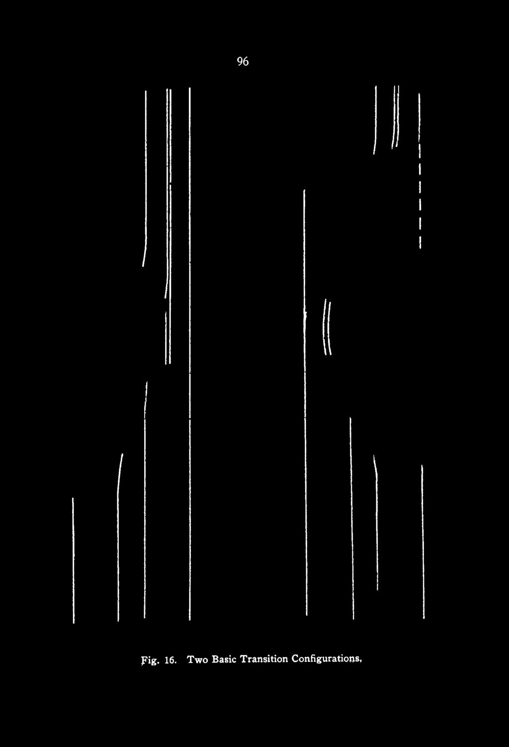
27 96 Fig. 16. Two Basic Transition Configurations,


28 97 problems. Figure 16 illustrates the two basic transition configurations. Configuration A is very poor design and should never be used as it requires drivers to read and understand signing instructing them to bear right to enter the transition in the right direction. This is not in accordance with the principles developed earlier, namely, that wrongway movement prevention systems should not depend on signing. Configuration B is much better practice and should always be used. M A JO R FIN D IN G S O F T H E S T U D Y The major findings of this study are summarized below: 1. O f the 96 accidents that occurred during the three-year period, 27 had one or more fatalities, 29 had one or more injuries, and 40 resulted in property damage. Only 37 accidents occurred on fully controlled access highways, but these accounted for 17 of the fatal accidents. 2. Wrong-way accidents are more severe but occur less frequently on highways with fully controlled access than on those without. 3. Wrong-way accidents occur most frequently on Fridays, Saturdays, and Sundays and also between 6 p.m. and 4 a.m. Only 26 percent of the 96 wrong-way accidents occurred during daylight. 4. Wrong-way drivers tend to be drunk (42 of 77 observations), tend to be older, or tend to be driving late at night when they are likely to be fatigued. 5. Only 31 percent of the 96 wrong-way drivers were not adversely influenced by advanced age, fatigue, and/or alcohol consumption. 6. Wrong-way movements tended to originate from areas with low land-use density. 7. Wrong-way movements tended to take place where and when traffic volumes were low. This is probably because when volumes are low, traffic is not present to indicate the correct direction of travel for each roadway. 8. Wrong-way movements tended to take place at times of low visibility. 9. Signing at most wrong-way movement sites was good. Driveway access points were the exception, where little or no signing was the rule. 10. T w o types of design elements that had potential to reduce the frequency of wrong-way movements were isolated. Any design


29 98 that increases the drivers ability to see and understand the overall intersection configuration would likely reduce wrongway movements. Also, the use of channelizing islands and curbs to impede potential wrong-way movements appeared to be useful. 11. The ability, motivation, and/or performance of most wrong-way drivers was reduced by adverse influencing factors. Therefore, the most effective wrong-way movement prevention systems will be those which function even if adverse influencing factors are present. 12. Geometric design modifications to reduce wrong-way movements at certain locations were developed. Modifications included channelization at diamond and parclo interchanges and raising the crossroad elevation at divided highway intersections and directional driveways. REFERENCES 1. Scifres, Peter N., Wrong-JVay Movements on Divided Highways, Joint Highway Research Project, Purdue University, February Tamburri, T. N., W rong-w ay Driving Accidents are Reduced, Highway Research Record Number 292, pp Friebele, John D.; Messer, C. J.; and Dudek, C. L., State-of-the- Art of W rong-w ay Driving on Freeways and Expressways, Texas Transportation Institute Research Report Number 139-7, June Mills, J. P., W rong-w ay Driving in Virginia, paper presented at the 1972 summer meeting of the A A SH O Operating Subcommittee on Traffic Engineering. 5. Winfrey, Economic Analysis of Highways, International Textbook Company, Scranton, Pennsylvania, 1969.
Bicycle - Motor Vehicle Collisions on Controlled Access Highways in Arizona
 Bicycle - Motor Vehicle Collisions on Controlled Access Highways in Arizona Analysis from January 1, 1991 to June 30, 2002 Richard C. Moeur, PE Traffic Design Manager, Northern Region Michelle N. Bina
1.3.4 CHARACTERISTICS OF CLASSIFICATIONS
 Geometric Design Guide for Canadian Roads 1.3.4 CHARACTERISTICS OF CLASSIFICATIONS The principal characteristics of each of the six groups of road classifications are described by the following figure
Access Location, Spacing, Turn Lanes, and Medians
 Design Manual Chapter 5 - Roadway Design 5L - Access Management 5L-3 Access Location, Spacing, Turn Lanes, and Medians This section addresses access location, spacing, turn lane and median needs, including
Grade Separated Intersection
 Grade Separated Intersection Lecture Notes in Transportation Systems Engineering Prof. Tom V. Mathew Contents 1 Overview 1 2 Classification of Intersection 2 2.1 Grade Separated Intersection...........................
MUTCD Part 6G: Type of Temporary Traffic Control Zone Activities
 MUTCD Part 6G: Type of Temporary Traffic Control Zone Activities 6G.01 Typical Applications Each temporary traffic control (TTC) zone is different. Many variables, such as location of work, highway type,
Chapter 33. Grade Separated Intersection Overview Classification of Intersection Grade Separated Intersection
 Chapter 33 Grade Separated Intersection 33.1 Overview An intersection is the area shared by the joining or crossing of two or more roads. Since the main function of an intersection is to enable the road
Chapter 5 DATA COLLECTION FOR TRANSPORTATION SAFETY STUDIES
 Chapter 5 DATA COLLECTION FOR TRANSPORTATION SAFETY STUDIES 5.1 PURPOSE (1) The purpose of the Traffic Safety Studies chapter is to provide guidance on the data collection requirements for conducting a
Recommended Roadway Plan Section 2 - Land Development and Roadway Access
 Recommended Roadway Plan Section 2 - Land Development and Roadway Access SECTION 2 Land Development and Roadway Access 2.1 Land Use and Access Management The Federal Highway Administration (FHWA) defines
Access Management in the Vicinity of Intersections
 Access Management in the Vicinity of Intersections FHWA-SA-10-002 Technical Summary Photo: Ralph Bentley (used with permission) 0 Access Management is: The design, implementation and management of entry
At-Grade Intersections versus Grade-Separated Interchanges (An Economic Analysis of Several Bypasses)
") Transportation Kentucky Transportation Center Research Report University of Kentucky Year 1975 At-Grade Intersections versus Grade-Separated Interchanges (An Economic Analysis of Several Bypasses) Kenneth
Transportation Kentucky Transportation Center Research Report University of Kentucky Year 1975 At-Grade Intersections versus Grade-Separated Interchanges (An Economic Analysis of Several Bypasses) Kenneth
DEFINITIONS Activity Area - Advance Warning Area Advance Warning Sign Spacing Advisory Speed Approach Sight Distance Attended Work Space
 DEFINITIONS Activity Area - that part of a TTC zone activity area where the work actually takes place. It consists of the work space, traffic space and one or more buffer spaces. Advance Warning Area -
CHAPTER 1 STANDARD PRACTICES
 CHAPTER 1 STANDARD PRACTICES OBJECTIVES 1) Functions and Limitations 2) Standardization of Application 3) Materials 4) Colors 5) Widths and Patterns of Longitudinal Pavement Marking Lines 6) General Principles
Defining Purpose and Need
 Advanced Design Flexibility Pilot Workshop Session 4 Jack Broz, PE, HR Green May 5-6, 2010 Defining Purpose and Need In your agency s project development process, when do design engineers typically get
City of Homewood Transportation Plan
 City of Homewood Transportation Plan Prepared for: City of Homewood, Alabama Prepared by: Skipper Consulting, Inc. May 2007 TABLE OF CONTENTS INTRODUCTION... 1 BACKGROUND INFORMATION... 1 EXISTING TRANSPORTATION
Characteristics of Traffic Accidents in Highway Work Zones
 Characteristics of Traffic Accidents in Highway Work Zones A DETAILED ANALYSIS OF WORK ZONE ACCIDENTS REPORTED ON NEW YORK STATE DEPARTMENT OF TRANSPORTATION CONSTRUCTION PROJECTS ESTABLISHED THE PREDOMINANT
CHAPTER 7 ACCESS MANAGEMENT. Background. Principles of Access Management. Hennepin County Transportation Systems Plan (HC-TSP)
") CHAPTER 7 ACCESS MANAGEMENT Background Principles of Access Management Hennepin County Transportation Systems Plan (HC-TSP) Chapter 7 Access Management 7.1 Background Access management has become an important
CHAPTER 7 ACCESS MANAGEMENT Background Principles of Access Management Hennepin County Transportation Systems Plan (HC-TSP) Chapter 7 Access Management 7.1 Background Access management has become an important
TRAFFIC CALMING GUIDE FOR TORONTO CITY OF TORONTO TRANSPORTATION SERVICES DIVISION
 TRAFFIC CALMING GUIDE FOR TORONTO CITY OF TORONTO TRANSPORTATION SERVICES DIVISION CITY OF TORONTO TRANSPORTATION SERVICES DIVISION 2016 TRAFFIC CALMING GUIDE FOR TORONTO TABLE OF CONTENTS Introduction
Road Accident Analysis and Identify the black spot location On State Highway-5 (Halol-Godhra Section)
") Road Accident Analysis and Identify the black spot location On State Highway-5 (Halol-Godhra Section) 1 Shah Dhruvit, 2 Shah Pranay M. 1 M.E civil(transportation), 2 M.E civil, P.h.d.(pursuing) 1 Tatva
Road Accident Analysis and Identify the black spot location On State Highway-5 (Halol-Godhra Section) 1 Shah Dhruvit, 2 Shah Pranay M. 1 M.E civil(transportation), 2 M.E civil, P.h.d.(pursuing) 1 Tatva
Chapter 4 Traffic Analysis
 Chapter 4 Traffic Analysis PURPOSE The traffic analysis component of the K-68 Corridor Management Plan incorporates information on the existing transportation network, such as traffic volumes and intersection
Use of Acceleration-Deceleration Lanes
 Use of Acceleration-Deceleration Lanes INTRODUCTION N eddy C. J ouzy, Graduate Assistant and Harold L. M ichael, Assistant Director Joint Highway Research Project Purdue University On the basis of various
VDOT Crash Analysis Procedures for Roadway Safety Assessments
 Crash analysis is a critical component of road safety analysis. The crash analysis procedures defined in this document will help: Identify where to target resources for detailed crash analysis Assess the
 http://www.itarda.or.jp/english/info36/36top.html Page 1 of 2 Introduction It is difficult to understand how someone could end up driving in the wrong direction on the highway. However, 1 in 300 accidents
INDEX. Geometric Design Guide for Canadian Roads INDEX
 Acceleration lane, see Lanes, Acceleration Access, 8.1 Access Management and Functional Classification 8.2 Access Management by Design Classification 8.3 Access Configuration 8.4 Building Set-Back Guidelines
CHAPTER 3A. GENERAL PAGE CHAPTER 3B. PAVEMENT AND CURB MARKINGS PAGE
 Virginia Supplement to the 2009 MUTCD Revision 1 Page TC-3-1 PART 3. MARKINGS CHAPTER 3A. GENERAL PAGE Section 3A.01 Functions and Limitations Section 3A.02 Standardization of Application Section 3A.03
Relative safety of alternative intersection designs
 Urban Transport XII: Urban Transport and the Environment in the 21st Century 379 Relative safety of alternative intersection designs L. C. Wadhwa 1 & M. Thomson 2 1 James Cook University Townsville Queensland
City of Prince Albert Statement of POLICY and PROCEDURE. Department: Public Works Policy No. 66. Section: Transportation Issued: July 14, 2014
 Page: 1 of 8 1 POLICY 1.01 The City shall follow all of the specifications in the Manual of Uniform Traffic Control Devices for Canada, prepared by the National Committee of Uniform Traffic Control, and
Chapter 2: Standards for Access, Non-Motorized, and Transit
 Standards for Access, Non-Motorized, and Transit Chapter 2: Standards for Access, Non-Motorized, and Transit The Washtenaw County Access Management Plan was developed based on the analysis of existing
ENHANCED PARKWAY STUDY: PHASE 2 CONTINUOUS FLOW INTERSECTIONS. Final Report
 Preparedby: ENHANCED PARKWAY STUDY: PHASE 2 CONTINUOUS FLOW INTERSECTIONS Final Report Prepared for Maricopa County Department of Transportation Prepared by TABLE OF CONTENTS Page EXECUTIVE SUMMARY ES-1
LAGUNA BEACH POLICE DEPARTMENT MEMORANDUM
 LAGUNA BEACH POLICE DEPARTMENT MEMORANDUM TO: FROM: Christa Johnson, Assistant City Manager Jason C. Kravetz, Captain DATE: January 16, 2015 SUBJECT: Laguna Canyon Road Collision Analysis Within the last
Recently Developed Intersection CMFs. Nancy Lefler, VHB ATSIP Traffic Records Forum, 2014
 Recently Developed Intersection CMFs Nancy Lefler, VHB ATSIP Traffic Records Forum, 2014 Overview General Methodology Treatments Installation of traffic signals - with and without left-turn lanes (NCDOT)
Background on the Revisions to VDOT s Access Management Spacing Standards
 December 2011 Background on the Revisions to VDOT s Access Management Spacing Standards Spacing Standards for Commercial Entrances, Signals, Intersections, and Crossovers The spacing standards were located
Truck Climbing Lane Traffic Justification Report
 ROUTE 7 (HARRY BYRD HIGHWAY) WESTBOUND FROM WEST MARKET STREET TO ROUTE 9 (CHARLES TOWN PIKE) Truck Climbing Lane Traffic Justification Report Project No. 6007-053-133, P 101 Ι UPC No. 58599 Prepared by:
Traffic Control and Accidents at Rural High-Speed Intersections
 14 TRANSPORTATION RESEARCH RECORD 1160 Traffic Control and Accidents at Rural High-Speed Intersections KENNETH R. AGENT ln many Instances, when rural high-speed highways are constructed, there are a number
Traffic Impact Analysis Walton Acres at Riverwood Athletic Club Clayton, NC
 Traffic Impact Analysis Walton Acres at Riverwood Athletic Club Clayton, NC 1. TABLE OF CONTENTS INTRODUCTION...1 1.1. Site Location and Study Area...1 1.2. Proposed Land Use and Site Access...2 1.3.
91
 90 91 92 93 94 95 96 97 98 99 100 101 102 103 104 105 106 As previously depicted in Exhibit 4-J, vehicular accidents are shown along Forrester Road. The contributing factors may be due to its current two
M-58 HIGHWAY ACCESS MANAGEMENT STUDY Mullen Road to Bel-Ray Boulevard. Prepared for CITY OF BELTON. May 2016
 M-58 HIGHWAY ACCESS MANAGEMENT STUDY Prepared for CITY OF BELTON By May 2016 Introduction Missouri State Highway 58 (M-58 Highway) is a major commercial corridor in the City of Belton. As development has
DOT HS September Crash Factors in Intersection-Related Crashes: An On-Scene Perspective
 DOT HS 811 366 September 2010 Crash Factors in Intersection-Related Crashes: An On-Scene Perspective DISCLAIMER This publication is distributed by the U.S. Department of Transportation, National Highway
Designing for Pedestrian Safety. Alabama Department of Transportation Pre-Construction Conference May 2016
 Designing for Pedestrian Safety Alabama Department of Transportation Pre-Construction Conference May 2016 1 Designing for Pedestrians Marking Crosswalks at Signalized intersections High Visibility Markings
MEMORANDUM. Charlotte Fleetwood, Transportation Planner
 MEMORANDUM Date: Updated August 22, 2017 To: Organization: Charlotte Fleetwood, Transportation Planner Boston Transportation Department From: Jason DeGray, P.E., PTOE, Regional Director of Engineering
Chapter 5 FUNCTIONAL CLASSIFICATION
 Chapter 5 FUNCTIONAL CLASSIFICATION Functional classification is a system by which streets and roadways may be distinguished by types according to their function within the entire transportation network.
CITY OF SASKATOON COUNCIL POLICY
 ORIGIN/AUTHORITY Clause 1, Report No. 1-1980 and Clause 4, Report No. 22-1990 of the Works and Utilities Committee; Clause 6, Report No. 17-2004 of the Planning and Operations Committee; and Clause D5,
INTRODUCTION THOROUGHFARE SYSTEM CLASSIFICATIONS
 INTRODUCTION The thoroughfare plan will assist public officials in the development of a specialized system for efficient and safe movement of vehicular traffic while minimizing potential conflicts with
APPENDIX A TWO-LANE RURAL ROADS ELEMENTS OF DESIGN CREST VERTICAL CURVES
 APPENDIX A TWO-LANE RURAL ROADS ELEMENTS OF DESIGN CREST VERTICAL CURVES 1. Two-lane Rural Roads 1.1 Introduction The definition of rural area can be derived from the definition of urban areas. Officially,
BLOSSOM AT PICKENS SIGNALIZED INTERSECTION IMPROVEMENT STUDY
 BLOSSOM AT PICKENS SIGNALIZED INTERSECTION IMPROVEMENT STUDY Class Project Report for ECIV 542 Traffic Engineering Submitted by Omor Sharif Muchun Song Narges Kaveshgar Quyen Pham Chih-Yao Lin Submission
Evaluation of M-99 (Broad Street) Road Diet and Intersection Operational Investigation
 Road Diet and Intersection Operational Investigation") Evaluation of M-99 (Broad Street) Road Diet and Intersection Operational Investigation City of Hillsdale, Hillsdale County, Michigan June 16, 2016 Final Report Prepared for City of Hillsdale 97 North Broad
Evaluation of M-99 (Broad Street) Road Diet and Intersection Operational Investigation City of Hillsdale, Hillsdale County, Michigan June 16, 2016 Final Report Prepared for City of Hillsdale 97 North Broad
Safety Assessment of Installing Traffic Signals at High-Speed Expressway Intersections
 Safety Assessment of Installing Traffic Signals at High-Speed Expressway Intersections Todd Knox Center for Transportation Research and Education Iowa State University 2901 South Loop Drive, Suite 3100
CITY OF ROCK HILL, SOUTH CAROLINA. Neighborhood Traffic Calming Program A Policy for Use of Traffic Calming on Local (Residential) Streets
 Streets") CITY OF ROCK HILL, SOUTH CAROLINA Neighborhood Traffic Calming Program A Policy for Use of Traffic Calming on Local (Residential) Streets I. Statement of Purpose: This program provides a process and a
CITY OF ROCK HILL, SOUTH CAROLINA Neighborhood Traffic Calming Program A Policy for Use of Traffic Calming on Local (Residential) Streets I. Statement of Purpose: This program provides a process and a
Effects of Traffic Signal Retiming on Safety. Peter J. Yauch, P.E., PTOE Program Manager, TSM&O Albeck Gerken, Inc.
 Effects of Traffic Signal Retiming on Safety Peter J. Yauch, P.E., PTOE Program Manager, TSM&O Albeck Gerken, Inc. Introduction It has long been recognized that traffic signal timing can have an impact
Appendix A: Safety Assessment
 Appendix A: Safety Assessment Safety Assessment Appendix A A Statement of Philosophy The efficient and responsible investment of resources in addressing safety problems is a difficult task. Since crashes
MUNICIPALITY OF ANCHORAGE Traffic Department MEMORANDUM
 MUNICIPALITY OF ANCHORAGE DATE: MEMORANDUM TO: FROM: SUBJECT: Anchorage Contractors, Builders, Designers, and Land Owners Robert E. Kniefel, P.E., Municipal Traffic Engineer Municipal Driveway Standards
Technical Memorandum. Subject: Interchange Ramp Terminal Configuration. Expiration. Implementation. Introduction
 Minnesota Department of Transportation Engineering Services Division Technical Memorandum To: Electronic Distribution Recipients From: Nancy T. Daubenberger, P.E. Assistant Commisioner, Engineering Services
Chapter 6. Analysis of the framework with FARS Dataset
 Chapter 6 Analysis of the framework with FARS Dataset. Having represented each phase of the structure with the aid of different data sets at each stage, to support the efficacy of the proposed framework
Phase I-II of the Minnesota Highway Safety Manual Calibration. 1. Scope of Calibration
 TECHNICAL MEMORANDUM Phase I-II of the Minnesota Highway Safety Manual Calibration PREPARED FOR: PREPARED BY: Minnesota Department of Transportation Richard Storm, CH2M HILL Veronica Richfield, CH2M HILL
TRAFFIC ACCIDENT ANALYSIS
 TRAFFIC ACCIDENT ANALYSIS Westheimer at Chimney Rock and Westheimer at Dunvale Prepared for Prepared by Klotz Associates, Inc. 1160 Dairy Ashford, Suite 500 Houston, Texas 77079 The preparation of this
10.0 CURB EXTENSIONS GUIDELINE
 10.0 CURB EXTENSIONS GUIDELINE Road Engineering Design Guidelines Version 1.0 March 2017 City of Toronto, Transportation Services City of Toronto Page 0 Background In early 2014, Transportation Services
Appendix 9.A - Interchanges Figure 9-A-1 Four-leg Interchanges between Expressways
 374 The Guidelines for Road Design Appendix 9.A - Interchanges Figure 9-A-1 Four-leg Interchanges between Expressways 375 The Guidelines for Road Design Figure 9-A-2 Three-leg Interchanges between Expressways
Unit 7 Speed, Travel Time and Delay Studies
 Unit 7 Speed, Travel Time and Delay Studies Introduction Speed, travel time and delay are all related measures that are common used as indicators of performance for traffic facilities Measure of Effectiveness
Figure 1: Graphical definitions of superelevation in terms for a two lane roadway.
 Iowa Department of Transportation Office of Design Superelevation 2A-2 Design Manual Chapter 2 Alignments Originally Issued: 12-31-97 Revised: 12-10-10 Superelevation is the banking of the roadway along
Appendix C. TRAFFIC CALMING PROGRAM TOOLBOX
 Appendix C. TRAFFIC CALMING PROGRAM TOOLBOX PHASE I...2 Do Not Enter Sign...3 One-Way Sign...4 Turn Prohibition...5 Pavement Markings...6 Speed Monitoring Trailer...7 Neighborhood Speed Watch...8 Police
1 VicRoads Access Management Policies May 2006 Ver VicRoads Access Management Policies May 2006 Version 1.02
 1 VicRoads Access Management Policies May 2006 Ver 1.02 VicRoads Access Management Policies May 2006 Version 1.02 2 VicRoads Access Management Policies May 2006 Ver 1.02 FOREWORD FOR ACCESS MANAGEMENT
MUTCD Part 6: Temporary Traffic Control
 MUTCD Part 6: Temporary Traffic Control OMUTCD English units are preferred. OHIO MANUAL OF UNIFORM TRAFFIC CONTROL DEVICES TABLE OF CONTENTS PREFACE INTRODUCTION TABLE OF CONTENTS PART 1. GENERAL Chapter
North Carolina. Bicycle Crash Facts Prepared for
 North Carolina Bicycle Crash Facts 2006-2010 Prepared for The North Carolina Department of Transportation Division of Bicycle and Pedestrian Transportation Prepared by The University of North Carolina
A Traffic Operations Method for Assessing Automobile and Bicycle Shared Roadways
 A Traffic Operations Method for Assessing Automobile and Bicycle Shared Roadways A Thesis Proposal By James A. Robertson Submitted to the Office of Graduate Studies Texas A&M University in partial fulfillment
Crash Analysis of I-64 Closure in St. Louis County
 Report # MATC-MST: 341 Final Report 25-1121-0001-341 Crash Analysis of I-64 Closure in St. Louis County Ghulam H. Bham, Ph.D. Professor Department of Civil, Architectural, and Environmental Engineering
Alberta Infrastructure HIGHWAY GEOMETRIC DESIGN GUIDE AUGUST 1999
 Alberta Infrastructure HIGHWAY GEOMETRIC DESIGN GUIDE AUGUST 1999,1'(; A ACCELERATION Data on acceleration from stop D-29 Effects of grade D-35 Intersections D-97, D-99 Lanes D-97, F-5, F-7, F-15, F-21,
3.9 - Transportation and Traffic
 Transportation and Traffic 3.9 - Transportation and Traffic This section describes the potential transportation and traffic effects of project implementation on the project site and its surrounding area.
A Study of School Crossing Protection
 A Study of School Crossing Protection F. D. M iller, Traffic Engineer St. Louis County, Missouri H. L. M ichael, Associate Director Joint Highway Research Project IN TR O D U C TIO N The problem of providing
An Analysis of the Travel Conditions on the U. S. 52 Bypass. Bypass in Lafayette, Indiana.
 An Analysis of the Travel Conditions on the U. S. 52 Bypass in Lafayette, Indiana T. B. T readway Research Assistant J. C. O ppenlander Research Engineer Joint Highway Research Project Purdue University
JONESBORO HIGHWAY 63 HIGHWAY 18 CONNECTOR STUDY
 JONESBORO HIGHWAY 63 HIGHWAY 18 CONNECTOR STUDY Craighead County May 2007 JONESBORO HIGHWAY 63 HIGHWAY 18 CONNECTOR STUDY Craighead County May 2007 Prepared by Planning and Research Division Arkansas State
Route 28 (South Orleans Road)/Route 39 (Harwich Road)/Quanset Road Intersection
/Route 39 (Harwich Road)/Quanset Road Intersection") TRAFFIC FEASIBILITY STUDY Route 28 (South Orleans Road)/Route 39 (Harwich Road)/Quanset Road Intersection Orleans, Massachusetts Prepared for: Town of Orleans Prepared by: Fay, Spofford & Thorndike, LLC
TRAFFIC FEASIBILITY STUDY Route 28 (South Orleans Road)/Route 39 (Harwich Road)/Quanset Road Intersection Orleans, Massachusetts Prepared for: Town of Orleans Prepared by: Fay, Spofford & Thorndike, LLC
DESIGN BULLETIN #66/2010
 DESIGN BULLETIN #66/2010 Highway Geometric Design Guide Chapter B, Climbing Lane Warrants for Two Lane Undivided and Four Lane Divided Highways - Revised Summary This Design Bulletin is being issued as
SECTION 12 ROAD MARKINGS AND DELINEATION
 SECTION 12 ROAD MARKINGS AND DELINEATION (Blank Page) MANUAL OF TRAFFIC SIGNS AND MARKINGS - Part III: Motorways and Expressways 12-1 12.1 GENERAL 12.1.1 INTRODUCTION The markings and delineation details
A plan for improved motor vehicle access on Railroad Avenue in Provincetown
 A plan for improved motor vehicle access on Railroad Avenue in Provincetown February 2011 A plan for improved motor vehicle access on Railroad Avenue in Provincetown INTRODUCTION AND PROBLEM IDENTIFICATION
APPENDIX D LEVEL OF TRAFFIC STRESS METHODOLOGY
 APPENDIX D LEVEL OF TRAFFIC STRESS METHODOLOGY 01 WHAT IS LEVEL OF TRAFFIC STRESS? When people bicycle on roadways, they encounter varying levels of stress from traffic. A quiet residential street with
THE DEVELOPMENT OF MALAYSIAN HIGHWAY RAIL LEVEL CROSSING SAFETY SYSTEMS: A PROPOSED RESEARCH FRAMEWORK. Siti Zaharah Ishak
 THE DEVELOPMENT OF MALAYSIAN HIGHWAY RAIL LEVEL CROSSING SAFETY SYSTEMS: A PROPOSED RESEARCH FRAMEWORK Siti Zaharah Ishak Transport System Centre, School of Natural & Built Environments, University Of
INTERSECTIONS AT GRADE INTERSECTIONS
 INTERSECTIONS 1 AT GRADE INTERSECTIONS INTERSECTIONS INTERSECTIONS = INTERRUPTED FACILITIES Definitions and key elements An intersection is defined as an area where two or more roadways join or cross.
Appendix A: Crosswalk Policy
 Appendix A: Crosswalk Policy Appendix A: Crosswalk Policy Introduction This citywide Crosswalk Policy is aimed at improving pedestrian safety and enhancing pedestrian mobility by providing a framework
Traffic Accident Data Processing
 Traffic Accident Data Processing D o n a l d F. P e t t y Engineer of Traffic Research and Surveys Indiana State Highway Commission The following is a portion of the Highway Safety Program Standards developed
Chapter Twenty-eight SIGHT DISTANCE BUREAU OF LOCAL ROADS AND STREETS MANUAL
 Chapter Twenty-eight SIGHT DISTANCE BUREAU OF LOCAL ROADS AND STREETS MANUAL Jan 2006 SIGHT DISTANCE 28(i) Chapter Twenty-eight SIGHT DISTANCE Table of Contents Section Page 28-1 STOPPING SIGHT DISTANCE
Borough of Danville, PA Traffic Calming Program Guidelines
 Borough of Danville, PA Traffic Calming Program Guidelines Adopted by Borough Council on 1 INTRODUCTION Speeding Traffic is a major concern in the Borough of Danville because of its detrimental impacts
Crash Patterns in Western Australia. Kidd B., Main Roads Western Australia Willett P., Traffic Research Services
 Crash Patterns in Western Australia Kidd B., Main Roads Western Australia Willett P., Traffic Research Services Abstract Examination of crash patterns is one way of identifying key factors on which focus
TRAFFIC IMPACT ANALYSIS
 TRAFFIC IMPACT ANALYSIS FOR THE CHAMPAIGN UNIT#4 SCHOOL DISTRICT PROPOSED HIGH SCHOOL (SPALDING PARK SITE) IN THE CITY OF CHAMPAIGN Final Report Champaign Urbana Urbanized Area Transportation Study 6/24/2014
DISTRIBUTION: Electronic Recipients List TRANSMITTAL LETTER NO. (13-01) MINNESOTA DEPARTMENT OF TRANSPORTATION. MANUAL: Road Design English Manual
 MINNESOTA DEPARTMENT OF TRANSPORTATION. MANUAL: Road Design English Manual") DISTRIBUTION: Electronic Recipients List MINNESOTA DEPARTMENT OF TRANSPORTATION DEVELOPED BY: Design Standards Unit ISSUED BY: Office of Project Management and Technical Support TRANSMITTAL LETTER NO.
DISTRIBUTION: Electronic Recipients List MINNESOTA DEPARTMENT OF TRANSPORTATION DEVELOPED BY: Design Standards Unit ISSUED BY: Office of Project Management and Technical Support TRANSMITTAL LETTER NO.
Roadway Conditions as Contributing Factors in Florida Traffic Crashes
 Roadway Conditions as Contributing Factors in Florida Traffic Crashes Michael R. Baltes and Xuehao Chu Center for Urban Transportation Research University of South Florida 4202 East Fowler Avenue, CUT
Figure 3B-1. Examples of Two-Lane, Two-Way Marking Applications
 Figure 3B-1. Examples of Two-Lane, Two-Way Marking Applications A - Typical two-lane, two-way marking with passing permitted in both directions B - Typical two-lane, two-way marking with no-passing zones
PEDESTRIAN COLLISIONS IN LOS ANGELES 1994 through 2000
 PEDESTRIAN COLLISIONS IN LOS ANGELES 1994 through 2000 City of Los Angeles Department of Transportation Gloria Jeff, General Manager March, 2006 This document printed with grant funds from the California
Safety and Design Alternatives for Two-Way Stop-Controlled Expressway Intersections
 Safety and Design Alternatives for Two-Way Stop-Controlled Expressway Intersections Thomas H. Maze Center for Transportation Research and Education Iowa State University 2901 South Loop Drive, Suite 3100
LYNNWOOD ROAD ARTERIAL STUDY The effect of intersection spacing on arterial operation
 LYNNWOOD ROAD ARTERIAL STUDY The effect of intersection spacing on arterial operation A J Joubert*, S L Burnett**, and T Ueckermann* *PWV Consortium, PO Box 1109, Sunninghill 2157 **Gautrans, Gauteng Department
Design Consistency and Multi-modal Safety in Urban Areas
 Design Consistency and Multi-modal Safety in Urban Areas Mitchell Jacobson, M.Sc., PEng., Transportation Engineer, Boulevard Transportation Tom Baumgartner, M.Sc., PEng., Transportation Engineer, Boulevard
Post impact trajectory of vehicles at rural intersections
 Post impact trajectory of vehicles at rural intersections Doecke SD., Woolley JE. and Mackenzie JR. Centre for Automotive Safety Research Abstract This report describes the path of vehicles after a collision
SELECTED ROADWAY CAPACITY ANALYSIS
 CHAPTERFOUR SELECTED ROADWAY CAPACITY ANALYSIS 4.1 SELECTED ROADWAY CAPACITY ANALYSIS Introduction Capacity analysis was performed on six selected roadways within the Dearborn County study area using the
Roundabout Design 101: Principles, Process, and Documentation
 Design 101: Principles, Process, and Documentation Part 1 March 7, 2012 Well designed roundabouts should minimize accidents, delay and costs for everyone using the intersection. This session covers the
Vision Zero High Injury Network Methodology
 Vision Zero High Injury Network Methodology DATA SETS USED: 1. Reportable crashes in Philadelphia from 2012-2016, available as open data through PennDOT 2. Street Centerline geographic layer, maintained
CHAPTER 8 STAKING SIGNALS AND LIGHTING FIELD GUIDE. 8.1 Staking Traffic Control Signal Systems
 CHAPTER 8 STAKING STAKING Correct staking of traffic control signal or lighting systems is critical to the appropriate placement of system components. 8.1 Traffic Control Signal Systems Locating the components
Access Management Benefits & Techniques. Access Management Workshop June 2, 2006
 Access Management Benefits & Techniques Access Management Workshop June 2, 2006 1 Benefits of Access Management Safety As access density increases, crash rates increase Increasing the density of access
General References Definitions. (1) Design Guidance. (2) Supporting Information
 Design Guidance. (2) Supporting Information") Chapter 1240 Turning Roadways 1240.01 General 1240.02 References 1240.03 Definitions 1240.04 Turning Roadway Widths 1240.05 Documentation 1240.01 General The roadway on a curve may need to be widened to
Chapter 1240 Turning Roadways 1240.01 General 1240.02 References 1240.03 Definitions 1240.04 Turning Roadway Widths 1240.05 Documentation 1240.01 General The roadway on a curve may need to be widened to
City of Wayzata Comprehensive Plan 2030 Transportation Chapter: Appendix A
 A1. Functional Classification Table A-1 illustrates the Metropolitan Council s detailed criteria established for the functional classification of roadways within the Twin Cities Metropolitan Area. Table
Attachment No. 17 GMI No. 1. National Committee on Uniform Traffic Control Devices GMI SIGNS TECHNICAL COMMITTEE RECOMMENDATION
 1 2 3 Attachment No. 17 GMI No. 1 4 5 6 7 8 9 10 11 12 13 14 15 16 17 18 19 20 21 22 23 24 25 26 27 28 29 30 31 32 33 34 35 36 37 GMI agenda item II.H.2., January 19, 2012 National Committee on Uniform
Capacity and Level of Service LOS
 Chapter 21 Capacity and Level of Service LOS 21.1 Introduction Often it is required to ascertain how much a transport facility can accommodate. Such information is useful in the design of traffic facility.
NEIGHBORHOOD TRAFFIC CALMING POLICY
 NEIGHBORHOOD TRAFFIC CALMING POLICY I. PURPOSE The City of Kent continually strives to strengthen and protect its neighborhoods by improving the quality of life in residential areas. Traffic conditions