MASONIC AVENUE STREET DESIGN STUDY Community Workshop 3. Masonic Ave Street Design Study Community Workshop 3 September 30, 2010
|
|
|
- Iris Hopkins
- 6 years ago
- Views:
Transcription

1 Masonic Ave Street Design Study Community Workshop 3 September 30, 2010
 701 4421 SF Department of Public Works Martha Ketterer, John Dennis, David Froehlich and Fiona Cundy SF Planning Department Nick Perry and Adam Varat Thanks to the SF Day School for")
2 Introduction MASONIC AVENUE STREET DESIGN STUDY Community Workshop 3 SF Municipal Transportation Agency Javad Mirabdal, Project Manager contact: Javad.Mirabdal@sfmta.com (415) SF Department of Public Works Martha Ketterer, John Dennis, David Froehlich and Fiona Cundy SF Planning Department Nick Perry and Adam Varat Thanks to the SF Day School for allowing us to use their space for the community workshop. Also, thanks to Elizabeth Macdonald s DCRP Studio at UC Berkeley for their Masonic Avenue analysis information, some of which we ve used in the presentation tonight.

3 Agenda MASONIC AVENUE STREET DESIGN STUDY Community Workshop 3 45 minutes Project overview Existing conditions Recap of community workshop 1 Recap of community workshop 2 and survey results Review new proposals 30 minutes Breakout to review new proposals Individual survey 30 minutes Regroup for discussion Next steps

4 Federal, State, Regional and City Policies Federal Planning Factors 23 CFR Safety for motorized and non motorized users State Policy AB1358 State Complete Street Policy MTC Resolution No MTC Complete Streets Policy SF City Charter Section 8A.115 SF Complete Streets Policy SF Admin Code Chapter 98 SF Better Streets Policy SF Public Works Code Section SF Complete Streets Policy


5 Project Area MASONIC AVENUE STREET DESIGN STUDY Community Workshop 3 Masonic Avenue from Fell Street to Geary Blvd. Geary Blvd. Masonic Ave. Fell St. Courtesy of UC Berkeley

6 Project Goals MASONIC AVENUE STREET DESIGN STUDY Community Workshop 3 The primary goal of this project is to identify how Masonic Avenue between Geary Blvd. and Fell St. can safely and efficiently accommodate the needs of all roadway users, including but not limited to pedestrians, bicyclists, motorists, and Muni.

7 Existing Conditions Topography, Street Networks, Schools, Parking, Muni Line, Sidewalk Widths

8 Existing Conditions Topography Lone Mountain The Panhandle Courtesy of UC Berkeley


9 Existing Conditions Street Networks Masonic Ave is the only through street running North/South between Park Presidio and Divisadero Streets. Geary Blvd. Fell St. North South Streets East West Streets


10 Existing Conditions Sidewalk Constraints Grade Changes Sidewalk Plantings Mature Street Trees
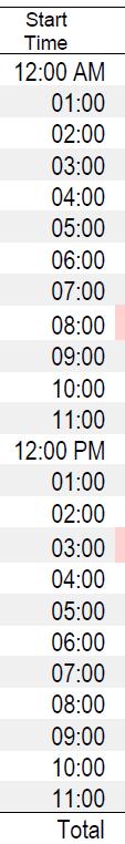
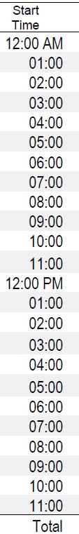
 Total daily ridership 12,765 Daily ridership between Geary and Fell")

11 Existing Conditions Transit Operation and Ameniti Bus Route 43 Masonic (9, 12, 10, 20 minutes) Total daily ridership 12,765 Daily ridership between Geary and Fell 1,461 Bus Route 31BX (9,, 11, minutes) 10 Bus Stops 5 stops are equipped with shelters and next bus Bus routes 38 & 38L Geary, 31 Turk, 5 Fulton, 21 Hayes and GGT cross Masonic.


12 Existing Conditions Parking 167 parking spaces total Geary St. Peak Tow Away Parking Lane West side Fell St. 84 East side

13 Existing Conditions Parking Occupancy

14 Existing Conditions Daytime Parking Duration

15 Existing Conditions Traffic Speed Study Speed Limit lowered from 30 MPH to 25 MPH on 6/24/08 After study on 9/8/10 found that average speed did not decrease More changes are needed to modify driver behavior
16 Existing Conditions Intersection Collision Summary Top 10 Collision Locations
17 Existing Conditions Traffic Volume Northbound at Fulton Southbound at Fulton
18 Existing Conditions PM Peak Southbound Traffic Modeling of Signal Delay Existing 3 Lanes Proposed 2 Lanes Intersection SB Delay (sec) SB Delay (sec) Masonic & Geary Masonic & Anza/O'Farrell (1 LT lane) 9 9 Masonic & Turk 5 15 Masonic & Golden Gate 4 5 Masonic & Fulton Masonic & Grove 2 3 Masonic & Hayes 4 9 Masonic & Fell (2 RT lanes) Masonic & Oak (1 LT lane) Total Delay Additional Delay 44
 Generally, two traffic lanes in each direction off peak AM tow away lane on east side (northbound), PM tow away lane on west side (southbound) Approx.")
19 Existing Conditions Typical Roadway Section Masonic Ave between Ewing and Fulton Property line to property line width is 100 ft Sidewalk width ranges from 9 ft (Hayes to Fell) to 22 ft (Ewing to Fulton) Generally, two traffic lanes in each direction off peak AM tow away lane on east side (northbound), PM tow away lane on west side (southbound) Approx. 83 parking spaces on west side and 84 parking spaces on east side

20 Existing Conditions Atypical Roadway Section Masonic Ave between Hayes and Fell
 Construction Duration: 1½ 2 yrs Cost: $10 15m")

21 Upcoming Major Projects Geary BRT Traffic at surface (2 lanes each direction) Construction Duration: 1½ 2 yrs Cost: $10 15m BRT in bus only tunnel; stations at tunnel approaches Traffic flows with additional turn restrictions Improved transfer to 43 Masonic


22 Upcoming major projects Proposed Target Project

23 Community Workshop 1 Comments, Small Group Conceptual Exercise, Community Priorities


24 Likes and Dislikes Community Workshop 1


25 Small Group Conceptual Exercise Community Workshop 1 Creating an Ideal Section

26 Community Workshop 2 Presentation of 4 Potential Street Design Options

27 Workshop 2: Option A East side parking, 4 traffic lanes, bike lane


28 Workshop 2: Option B Night parking, 4/2 traffic lanes, shifting bike lanes MASONIC AVENUE STREET DESIGN STUDY Community Workshop 3

29 Workshop 2: Option C No parking, 4 traffic lanes, cycle track
30 Workshop 2: Option D Parking at all times, 4 traffic lanes, cycle track on existing sidewalk Intersection Mid Block
31 100% 90% 80% 70% 60% 50% 40% 30% 20% 10% 0% MASONIC AVENUE STREET DESIGN STUDY Community Workshop 3 2% 24% 74% 69% 5% Workshop 2 Survey Results 16% 10% 16% 15% 15% 18% 42% 24% Overall Rankings Overall Rankings 24% 32% 34% 34% 18% 41% 26% Option A Option B Option C Option D Option A was the most liked Option C was the most strongly liked Strongly option. Dislike Somewhat Dislike Options B & D were Somewhat the most Like strongly Strongly Like disliked
32 100% 90% 80% 70% 60% 50% 40% 30% 20% 10% 0% MASONIC AVENUE STREET DESIGN STUDY Community Workshop 3 33% 50% 12% Workshop Traffic Lane Configuration 2 Survey Results Roadway with Median Configuration 10% 20% 27% 48% 41% 2% 17% 79% 8% 25% 35% 31% 33% OPTION A OPTION B OPTION C OPTION D Option C shows that four traffic lanes calmed with a median is preferred. Strongly Dislike Somewhat Dislike Somewhat Like Strongly Like
33 100% 90% 80% 70% 60% 50% 40% 30% 20% 10% 0% MASONIC AVENUE STREET DESIGN STUDY Community Workshop 3 2% 96% 67% 29% Workshop 2 Survey Results 12% 36% 31% 17% Transit Facilities Transit Facilities 7% 15% 49% 22% 3% 95% 45% 50% 3% OPTION A OPTION B OPTION C OPTION D Options A and D show that Bus bulbs with inside bike lanes was favored Strongly Dislike Somewhat Dislike Somewhat Like Strongly Like
34 100% 90% 80% 70% 60% 50% 40% 30% 20% 10% 0% MASONIC AVENUE STREET DESIGN STUDY Community Workshop 3 5% 12% 84% 60% 24% Workshop Bike Facility 2 Survey Design Results 20% 32% 32% 17% Bike Facility Design 7% 91% 2% 33% 58% 20% 12% 29% 39% OPTION A OPTION B OPTION C OPTION D Option A and C reflect permanent bike lanes or a cycle track in existing parking/tow away lane is preferred. Strongly Dislike Somewhat Dislike Somewhat Like Strongly Like
35 100% 90% 80% 70% 60% 50% 40% 30% 20% 10% 0% MASONIC AVENUE STREET DESIGN STUDY Community Workshop 3 68% 22% Workshop 2 Survey Results 43% Sidewalk Design 2% 2% 2% 13% 7% Sidewalk Design 44% 40% 44% 20% 42% 22% 41% 17% OPTION A OPTION B OPTION C OPTION D Option D reflects that a cycle track on the existing sidewalk was seen by many as a degradation of the pedestrian environment. Strongly Dislike Somewhat Dislike Somewhat Like Strongly Like
36 100% 90% 80% 70% 60% 50% 40% 30% 20% 10% 0% MASONIC AVENUE STREET DESIGN STUDY Community Workshop 3 5% 12% 60% Workshop Parking 2 Survey Results 19% 60% 34% 26% 33% 17% 21% Parking 34% 15% 12% 37% 17% 21% 29% 31% OPTION A OPTION B OPTION C OPTION D Option A (east side parking) was seen as a compromise by most; Option C (no parking) was the Strongly most polarizing Dislike Somewhat Dislike Somewhat Like Strongly Like
37 100% 90% 80% 70% 60% 50% 40% 30% 20% 10% 0% MASONIC AVENUE STREET DESIGN STUDY Community Workshop 3 26% 42% 28% Workshop Street Trees/Greening 2 Survey Results Median Street Trees 92% 91% 12% 5% 5% 5% 5% 36% 55% 24% 68% 27% 41% 17% OPTION A OPTION B OPTION C OPTION D Option B and C reveal that adding street trees via a landscape median is preferred. Strongly Dislike Somewhat Dislike Somewhat Like Strongly Like

38 Community Workshop 3 Proposals
39 The Gateway is a hybrid of Option A with added traffic calming elements The Boulevard is a hybrid of Option C with added traffic calming elements

40 The Gateway Section Rendering MASONIC AVENUE STREET DESIGN STUDY Community Workshop 3 East side parking, 4 traffic lanes, bike lanes, median at key intersections
41 The Gateway Plan View Rendering Block Plan View Masonic Ave

42 The Boulevard Section Rendering MASONIC AVENUE STREET DESIGN STUDY Community Workshop 3 No parking, 4 lanes, cycle track, median

43 The Boulevard Plan View Rendering Masonic Ave

44 Bus Bulb Plaza Illustration
45 Comparison of Proposals: The Gateway The Boulevard Features: Features: Pedestrian refuges at median intersections 5 Bus bulb plazas [primarily on the east side] Parking on eastside will be retained at all times 100 combination ped/roadway light fixtures 120 new street trees 34,000 sf additional sidewalk greening 10,000 sf permeable paving 5 wide bike lane Upgraded traffic signals Proposed new traffic signal at Ewing 11,000 sf plaza and public art space at Geary Estimated Cost: +/ $15 Million Construction Duration: 6 12 Months Pedestrian refuges at all intersections 8 Bus bulb plazas [east and west side] No parking spaces retained on Masonic 125 roadway and pedestrian light fixtures 200 new street trees 49,000 sf additional sidewalk greening 12,000 sf permeable paving 6 wide elevated cycle track Upgraded traffic signals Proposed new traffic signal at Ewing 11,000 sf plaza and public art space at Geary Estimated Cost +/ $20 Million Construction Duration: Months
46 Near Term Improvements: Radar Speed Signs Two signs installed between Golden Gate Av. and McAllister St. 25 MPH Speed Limit Signs Three additional signs installed on the west side of Masonic Signal Upgrade at Masonic and Fulton Upgraded all 8 traffic signals to 12 signals for all approaches Signal Timing Adjustments Analyzed signal timing along Masonic and expect to be implemented by the end of November

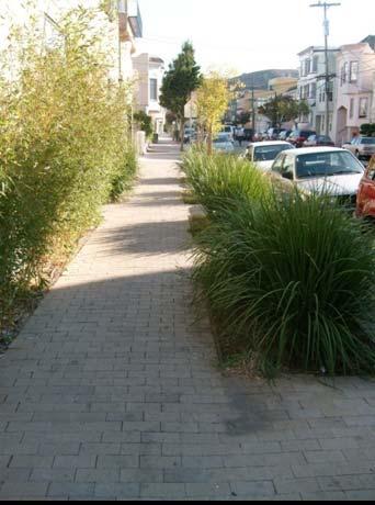
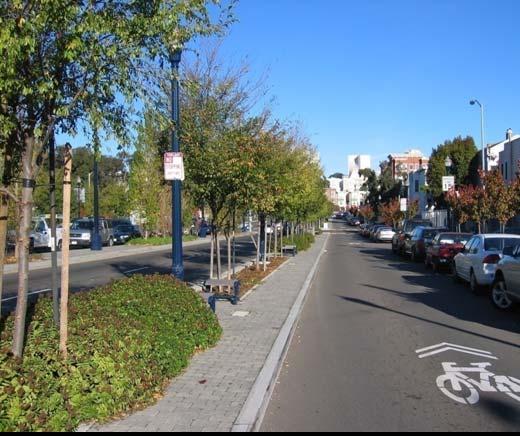
47 Streetscaping Amenities Sidewalk Plantings, Stormwater Planters, Landscaped Medians, Plazas andpublic Art, Site Furnishings and Lighting
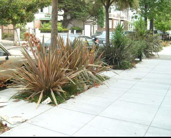
48 Streetscaping Amenities Sidewalk Plantings


49 Streetscaping Amenities Stormwater Planters Stormwater Planters: Minimize impervious surfaces Slow the entry of stormwater into sewers Use landscape features to treat runoff
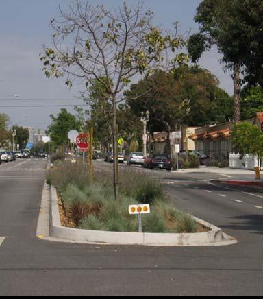
50 Streetscaping Amenities Landscaped Medians


51 Streetscaping Amenities Site Furnishings and Street Lighting Embarcadero Tear Drop Fixture Lumec Post Top Fixture


52 Streetscaping Amenities Plaza and Public Art Leland Avenue Pavement to Parks Program

53 Streetscaping Amenities Geary and Masonic Plaza and Public Art Space

54 Next Steps MASONIC AVENUE STREET DESIGN STUDY Community Workshop 3 Please be sure to leave your contact information on the sign in sheet if you would like to be informed of the upcoming events in the project, including: Workshop 3 survey results MTA website in Nov. Final report and selected option End of the year Environmental review Policy & board approval Obtain funding Design & construction

55 Break Out Time Reviewing Proposals & Survey
56 The Gateway The Boulevard

57 Discussion Questions & Answers
58 The Gateway The Boulevard

59 Thank You for attending and for your participation!
MASONIC AVENUE STREET DESIGN STUDY Community Workshop 2. Masonic Ave Street Design Study Community Workshop 2 August 10, 2010
 Masonic Ave Street Design Study Community Workshop 2 August 10, 2010 Introduction MASONIC AVENUE STREET DESIGN STUDY Community Workshop 2 SF Municipal Transportation Agency Javad Mirabdal, Project Manager
Protected Bike Lanes in San Francisco Mike Sallaberry SFMTA NACTO Workshop - Chicago IL
 Protected Bike Lanes in San Francisco Mike Sallaberry SFMTA 10 14 2011 NACTO Workshop - Chicago IL San Francisco 2 nd Highest Density in the U.S. 47 square miles Mild Climate Market Population ~810,000
Replace century-old sewer & water pipes Pedestrian-scale sidewalk lighting
 PROJECT OVERVIEW The Masonic Avenue Streetscape Project is an effort to improve safety for everyone travelling on Masonic Avenue between Geary Boulevard and Fell Street. This project will bring a variety
Memo. Ocean Avenue Corridor Design Project Public Workshop #2 Summary
 Ocean Avenue Corridor Design Project Public Workshop #2 Summary The second public workshop for the Ocean Avenue Corridor Design Project was held on Wednesday, May 14, 2014 from, 6 to 8 pm at Lick Wilmerding
Telegraph Avenue Complete Streets DRAFT Recommendations. Oakland Public Works Department September 11 and 13, 2014 Open Houses
 Telegraph Avenue Complete Streets DRAFT Recommendations Oakland Public Works Department September 11 and 13, 2014 Open Houses Presentation Overview What are complete streets? What problem are we trying
SAN FRANCISCO MUNICIPAL TRANSPORTATION AGENCY
 THIS PRINT COVERS CALENDAR ITEM NO. : 10.2 DIVISION: Sustainable Streets BRIEF DESCRIPTION: SAN FRANCISCO MUNICIPAL TRANSPORTATION AGENCY Adopting Conceptual Proposal for Streetscape Improvements to Broadway,
SFMTA PROJECT TIMELINE
 SFMTA PROJECT TIMELIE Internal SFMTA Processes Opportunities for Public Input Data Collection and Analysis Car and bike volumes, safety (collision) data Roadway and intersection geometry June 2016 Pop
City of Sammamish. Welcome. Issaquah-Fall City Road Improvements Project Phase I Design: 242nd Avenue SE to Klahanie Drive SE
 Welcome Welcome to the third community meeting for the Issaquah-Fall City Road Improvements Project. AGENDA 6:00 p.m. Welcome and sign-in 6:10 p.m. Presentation 6:50 p.m. Open house Learn about the roadway
Northbound San Jose Avenue & I-280 Off-Ramp Road Diet Pilot Project
 Project Overview Fed by a two-lane Interstate-280 (I-280) off-ramp, high vehicular volumes and speeds are longstanding issues along San Jose Avenue. Residents in the surrounding neighborhoods have expressed
Vision Zero Priority Projects (March 2017)
") Key in 201 or of Key Potrero Ave., from Division to Cesar Chavez Begin Construction Spring 201 Winter 201 Achieved Safety measures include dedicated transit lane, sidewalk widening, buffers for existing
Key in 201 or of Key Potrero Ave., from Division to Cesar Chavez Begin Construction Spring 201 Winter 201 Achieved Safety measures include dedicated transit lane, sidewalk widening, buffers for existing
Dr. M.L. King, Jr. Street North Complete Streets Resurfacing Opportunities HOUSING, LAND USE, AND TRANSPORTATION COMMITTEE MARCH 22, 2018
 Dr. M.L. King, Jr. Street North Complete Streets Resurfacing Opportunities HOUSING, LAND USE, AND TRANSPORTATION COMMITTEE MARCH 22, 2018 What s Happening The City plans to mill and resurface Dr. M.L.
Southview Blvd & 3 rd Avenue Improvement Project. Public Open House December 4, to 7pm
 Southview Blvd & 3 rd Avenue Improvement Project Public Open House December 4, 2014 5 to 7pm Southview Blvd & 3 rd Avenue Public Information Meeting Agenda Presentation 5:30 to 6:15 pm Purpose of Project
Chapter 3 BUS IMPROVEMENT CONCEPTS
 Chapter 3 BUS IMPROVEMENT CONCEPTS The purpose of this chapter is to describe potential bus improvement strategies and potential impacts or implications associated with BRT implementation within the existing
Geary Bus Rapid Transit Project
 Geary Bus Rapid Transit Project Outreach Update SAN FRANCISCO COUNTY TRANSPORTATION AUTHORITY SAN FRANCISCO MUNICIPAL TRANSPORTATION AGENCY April 28, 2016 Project Activities Since January Meeting Continued
Chapter 4 TOOLBOX AND SAMPLE BIKE BOULEVARD LAYOUT
 Chapter 4 TOOLBOX AND SAMPLE BIKE BOULEVARD LAYOUT OVERVIEW This chapter describes a cohesive set of strategies to create a bicycle boulevard, namely to make streets safer and more efficient for bicycle
STREETSCAPE CONCEPTS
 STREETSCAPE S CARGO WAY CARGO WAY CYCLE TRACK Streetscape Concepts JENNINGS ST Illustrative Plan EVANS AVE PG&E BAY TRAIL HERON S HEAD PARK The recommended improvements build off the planned improvements
Geary Bus Rapid Transit Project
 Geary Bus Rapid Transit Project Urban Forestry Council Planning and Funding Committee Meeting September 13, 2016 SAN FRANCISCO COUNTY TRANSPORTATION AUTHORITY SAN FRANCISCO MUNICIPAL TRANSPORTATON AGENCY
Hennepin Avenue Reconstruction Washington Avenue to 12 th Street
 CITY OF MINNEAPOLIS Hennepin Avenue Reconstruction Washington Avenue to 12 th Street April 2016 1 Upcoming Opportunities Public Meeting #2 April 25, 2016 Minneapolis Central Library Doty Board Room Repeat
Ocean Park Boulevard Green Street Project Alternatives & Trade Offs
 Planning Commission March 4, 2009 Ocean Park Boulevard Green Street Project Alternatives & Trade Offs Purpose of Tonight s Meeting Review concept plans and options Provide input on alternatives and trade-offs
Chapter 3: Multi-Modal Circulation and Streetscapes
 CHAPTER 3: MULTI-MODAL CIRCULATION AND STREETSCAPES Chapter 3: Multi-Modal Circulation and Streetscapes Overview Streetscape improvements have already been completed for Depot Street between Main Avenue
25th Avenue Road Diet Project A One Year Evaluation. Transportation Fund for Clean Air Project #05R07
 25th Avenue Road Diet Project A One Year Evaluation Transportation Fund for Clean Air Project #05R07 Submitted by: The San Francisco Municipal Transportation Agency Dan Provence May 22, 2009 EXECUTIVE
Geary Corridor Bus Rapid Transit SFMTA Citizens Advisory Committee
 Geary Corridor Bus Rapid Transit SFMTA Citizens Advisory Committee Project Update SAN FRANCISCO COUNTY TRANSPORTATION AUTHORITY SAN FRANCISCO MUNICIPAL TRANSPORTATION AGENCY August 6, 2015 Project Overview
Project Goal and Description. Why Broadway? Broadway SFMTA.COM/BROADWAY. The goal of the Broadway Safety Improvement
 PROJECT OVERVIEW Project Goal and Description The goal of the Broadway Safety Improvement d St Van Ness Ave Project is to improve safety and comfort for all who Franklin St Hyde St Octavia St Gough St
Henderson Ave. Complete Streets Project
 Henderson Ave. Complete Streets Project Meeting Purpose To finalize conceptual components of project prior to proceeding with preliminary engineering www.dallascompletestreets.wordpress.com MeetingAgenda
2014/2015 BIKE ROUTE PLAN 83 AVENUE PROTECTED BIKE LANE
 About the Project The City of Edmonton is planning a major bike route on the southside of Edmonton. The Strathcona Bike Route will connect the communities of Strathcona, Garneau and the University area,
Ocean Park Boulevard Green Street Project Community Workshop
 Ocean Park Boulevard Green Street Project Community Workshop 2.2.10 Project Objectives Community Priority: reclaim OPB for public open space. Build upon LUCE principles; neighborhood enhancement, connectivity,
MARTIN LUTHER KING JR. WAY
 OCTOBER 2011 40 Vision and Goals The Martin Luther King, Jr. Way Illustrative Master Plan that follows has been developed through a process of community involvement. It expresses a long term vision for
Lawrence Avenue Streetscape Concepts August 30, 2011
 Lawrence Avenue Streetscape Concepts August 30, 2011 Neighborhood Context Phase II: River to Western Ave. Phase I: Western Ave. to Clark St. Key Map Lawrence Ave. Existing Streetscape Conditions East of
Richmond-Adelaide Cycle Tracks
 Public Drop-In Event Richmond-Adelaide Cycle Tracks June 25, 2018 12:00 p.m. 3:00 p.m. 4:30 p.m. 7:30 p.m. Metro Hall, Rotunda 55 John Street 1 Purpose of Event In Scope Communicate an update about the
RIVERSIDE, Newton MA BH NORMANDY RIVERSIDE LLC. Riverside Station. A green, transit-oriented community
 Riverside Station A green, transit-oriented community October 6, 2011 TONIGHT S AGENDA: 1. Project Update (5 min.) 2. Master Plan Update (10 min.) 3.Traffic Plan Update (10 min.) Questions & Answers MASTER
2014/2015 BIKE ROUTE PLAN 83 AVENUE PROTECTED BIKE LANE
 About the Project 2014/2015 BIKE ROUTE PLAN The City of Edmonton is planning a major bike route on the south side of Edmonton. This bike route is one part of a plan to provide citizens with transportation
Ocean Park Boulevard Streetscape Improvement Project Alternatives & Trade Offs
 City Council Study Session January 27, 2009 Ocean Park Boulevard Streetscape Improvement Project Alternatives & Trade Offs Scope of Work Purpose of Tonight s Meeting Review work to date and direct staff
Outreach Approach RENEW SF served as the primary liaison with the North Beach community; the Chinatown. Executive Summary
 Executive Summary Executive Summary The Columbus Avenue Neighborhood Transportation Study s objective is to identify changes to transportation infrastructure and policies that could enhance the livability
Brooklyn Boulevard (County Road 152) Reconstruction Project Phase I. OPEN HOUSE June 20, 2017
 Reconstruction Project Phase I. OPEN HOUSE June 20, 2017") Brooklyn Boulevard (County Road 152) Reconstruction Project Phase I OPEN HOUSE June 20, 2017 Brooklyn Boulevard (County Road 152) Phase I Project Partners Project Lead Other Project Partners include Brooklyn
Brooklyn Boulevard (County Road 152) Reconstruction Project Phase I OPEN HOUSE June 20, 2017 Brooklyn Boulevard (County Road 152) Phase I Project Partners Project Lead Other Project Partners include Brooklyn
Van Ness Avenue BRT Overview and Scoping Process. Geary BRT CAC January 8, 2009
 Van Ness Avenue BRT Overview and Scoping Process Geary BRT CAC January 8, 2009 VAN NESS AVENUE S ROLE Identified in Prop K for BRT treatment Muni 47 and 49; 19 operates on Polk 20,000 daily riders on Van
Design Guidelines. Overview. Design Vision for Yellow Brick Road
 Design Guidelines Overview This section presents the design vision for the Yellow Brick Road network. The Yellow Brick Road is envisioned to be an interconnected network of safe and secure roadways where
Welcome! Thank you for joining us today for a Geary Rapid project open house. Geary Rapid Project. SFMTA.com/GearyRapid
 Welcome! Thank you for joining us today for a Geary Rapid project open house. Get the most out of this event: 1. Sign in and get your feedback sheet 2. Visit project information stations hosted by project
Bridges and Arizona Crossings
 Circulation and Transportation 5-11 Discovery Street/Barham Drive. Discovery Street is planned 5.4.3 Specific Plan Circulation Improvements to be extended eastward from its terminus at Craven Road Circulation
Palou Complete Street Project Barneveld Avenue to Crisp Road Project overview and concept design Community Meeting #2 May 13, 2015
 Palou Complete Street Project Barneveld Avenue to Crisp Road Project overview and concept design Community Meeting #2 May 13, 2015 Agenda Welcome and introductions Project overview, history and goals Concept
The Wiggle Route in Context
 The Wiggle Route in Context In a city of hills, the Wiggle is an important route because it winds its way along the flattest streets from Market to the Panhandle, bringing residents to local parks and
Dewey Area Traffic Calming Project
 SFMTA Municipal Transportation Agency Image: Crosswalk of California Street and Grant Avenue Dewey Area Traffic Calming Project 10 08 2013 SAN FRANCISCO, CALIFORNIA Tonight s Agenda Introductions Project
THE ALAMEDA CONCEPT DESIGN COMMUNITY MEETING 3. A Plan for The Beautiful Way JANUARY 28, 2010
 CONCEPT DESIGN COMMUNITY MEETING 3 JANUARY 28, 2010 AGENDA INTRODUCTION COMMUNITY INPUT ROADWAY STUDIES STREETSCAPE DESIGN STATIONS DISCUSSION SUMMARY AND DISCUSSION NEXT STEPS CLOSE INTRODUCTION SCHEDULE
Building Great Neighbourhoods BELLEVUE AND VIRGINIA PARK
 Building Great Neighbourhoods BELLEVUE AND VIRGINIA PARK This is Meeting 2 Unfortunately, some residents in Bellevue and Virginia Park received the wrong information for this public open house (Meeting
Polk Streetscape Project
 What is this project? The Polk Streetscape Project is an effort to improve safety for everyone traveling on Polk Street between Union and McAllister streets. Also included in this project are paving, sewer
Mission-Geneva Transportation Study Community Workshop 2 July 8, 2006
 Community Workshop 2 July 8, 2006 Small Group Workbook 1 Basic Improvements on Mission Street Streetscape. Pedestrian-scale lighting; landscaping; community art on utility boxes; more (possibly unique)
HARRISON STREET/OAKLAND AVENUE COMMUNITY TRANSPORTATION PLAN
 HARRISON STREET/OAKLAND AVENUE Community Workshop #4: Draft Plan Review December 3, 2009 D E S I G N, C O M M U N I T Y & E N V I R O N M E N T INTRODUCTIONS Key Project Staff: Alisa Shen, Project Manager,
Complete Streets Process and Case Study: Taft / McMillian Two-Way Street Conversion Cincinnati, Ohio. Traffic Engineering Workshop June 4, 2014
 Complete Streets Process and Case Study: Taft / McMillian Two-Way Street Conversion Cincinnati, Ohio Traffic Engineering Workshop June 4, 2014 Complete Streets Streets that enable safe access for users
Fifth & Kirkham Traffic-Calming Project. 5 th Avenue and Kirkham Street Presented at the UCSF Quarterly Parnassus Community Meeting May 3, 2018
 Fifth & Kirkham Traffic-Calming Project 5 th Avenue and Kirkham Street Presented at the UCSF Quarterly Parnassus Community Meeting May 3, 2018 1 Agenda Welcome and introductions Project history, goals,
FOLSOM-HOWARD STREETSCAPE OVERVIEW
 FOLSOM-HOWARD STREETSCAPE OVERVIEW SoMa residents should have the same kinds of amenities that other neighborhoods have. The Folsom- Howard Streetscape Project will make SoMa more livable by making it
ALTERNATIVES SCREENING REPORT
 VAN NESS AVENUE BUS RAPID TRANSIT (BRT) ALTERNATIVES SCREENING REPORT Revised Draft, 3/28/08 San Francisco County Transportation Authority 1 Introduction The San Francisco County Transportation Authority
Caltrans Sloat Boulevard Pedestrian Safety Project Response to Community Questions, Comments & Concerns
 Caltrans Sloat Boulevard Pedestrian Safety Project Response to Community Questions, Comments & Concerns Revised: May 10, 2016 The California Department of Transportation (Caltrans) is planning various
El Camino Real Specific Plan. TAC/CAC Meeting #2 Aug 1, 2018
 El Camino Real Specific Plan TAC/CAC Meeting #2 Aug 1, 2018 Land Use Alternatives Goals and Tradeoffs Parks & open space Housing Retail & services Civic spaces Parking Community gathering spaces 3 Alternatives
PROJECT OVERVIEW. 20th Avenue Project Limits (Lincoln Way to Wawona St)
") PROJECT OVERVIEW In 2014, San Francisco adopted Vision Zero as City policy, with a commitment to eliminate all traffic deaths in the City by 2024. nue Project Limits (Lincoln Way to St) Collision data
PROJECT OVERVIEW In 2014, San Francisco adopted Vision Zero as City policy, with a commitment to eliminate all traffic deaths in the City by 2024. nue Project Limits (Lincoln Way to St) Collision data
Central Freeway and Octavia Circulation Study
 Central Freeway and Octavia Circulation Study Final Report Plans and Programs Committee San Francisco County Transportation Authority September 18, 2012 Presentation Outline Background and Study Purpose
Road Diets FDOT Process
 Florida Department of TRANSPORTATION Road Diets FDOT Process Humberto Castillero, PE, PTOE Roadway Design Office Purpose of Guide Develop a statewide lane elimination review process Balance state & local
Bicycle Facilities Planning
 Bicycle Facilities Planning Overview Types of Cyclists Purpose for Riding Types of Facilities Bike Lanes Bicycle Boulevards Cycle Tracks Intersections Signals Signing and Marking Discussion Types of Bicyclists
California Department of Transportation, District 4. Sloat Boulevard Project Skyline Blvd. to 19 th Ave. Community Update January 13, 2016
 California Department of Transportation, District 4 Sloat Boulevard Project Skyline Blvd. to 19 th Ave. Community Update January 13, 2016 Agenda Welcome and introductions Project overview, history and
Item Description: Presentation and Discussion: Berkeley Rapid Transit Locally Preferred Alternative
 Office of the City Manager Meeting Date: April 29, 2010 Item Number: 1 Item Description: Presentation and Discussion: Berkeley Rapid Transit Locally Preferred Alternative Staff report, resolution, and
Station Plan: Penn & 43rd Avenue
 Station Plan: Penn & 43rd Avenue This station will serve the northern portion of the Penn Avenue corridor, including the commercial node at 44th Avenue. Ridership and roadway geometry support station siting
COWETA HIGH SCHOOL AND EAST HIGHWAY 51
 COWETA HIGH SCHOOL AND EAST HIGHWAY 51 Lack of sidewalks along Ben Lumpkin Rd. Lack of crosswalks and ramps at intersection. Hwy 51 is wide to cross as a pedestrian. No ADA compliance or connection to
Welcome! San Jose Avenue Open House August 25, 2015
 Welcome! San Jose Avenue Open House August 25, 2015 Vision Zero The City and County of San Francisco adopted Vision Zero San Francisco Vision Zero High Injury Network as a policy in 2014, committing an
WELCOME Mission-Geneva Transportation Study
 WELCOME Mission-Geneva Transportation Study Study Process and Schedule 2005 2006 Oct Nov Dec Jan Feb Mar Apr May Jun Jul Aug Sept Oct Task 2 Develop Outreach Plan Task 3 Document Existing Conditions/ Prioritize
Tonight is for you. Learn everything you can. Share all your ideas.
 Strathcona Neighbourhood Renewal Draft Concept Design Tonight is for you. Learn everything you can. Share all your ideas. What is Neighbourhood Renewal? Creating a design with you for your neighbourhood.
Bay to Bay Boulevard Complete Streets Project
 Bay to Bay Boulevard Complete Streets Project Dale Mabry Highway to Bayshore Boulevard February 08, 2018 Photo Source: Tampa Bay Times Alessandra Da Pra Meeting Format Introduction Resurfacing Information
City of Seattle Edward B. Murray, Mayor
 City of Seattle Edward B. Murray, Mayor Department of Transportation Scott Kubly, Director Eastlake Community Council 117 E Louisa St. #1 Seattle, WA 98102-3278 January 28, 2016 RE: Roosevelt to Downtown
Boston Post Road Design Feasibility Study
 Boston Post Road Design Feasibility Study Prepared for the City of Rye Final Report July 18, 2007 Prepared by: Buckhurst Fish & Jacquemart (BFJ) 115 Fifth Avenue New York, NY 10003 www.bfjplanning.com
COMMUNITY MEETING AGENDA
 COMMUNITY MEETING AGENDA Welcome and Introductions SAFE Presentation Project Presentation Priorities Feedback Next Steps Q&A Santa Cruz Avenue Corridor Study 1 Santa Cruz Avenue Corridor Study Community
APPENDIX D. May 22, 2002 Open House Summary and Materials
 APPENDIX D May 22, 2002 Open House Summary and Materials TH 36 Partnership Study Open House May 22, 2002 Summary of Survey Responses 1. If no new crossing of the St. Croix River is built (e.g. the existing
City of Wilsonville 5 th Street to Kinsman Road Extension Project
 City of Wilsonville 5 th Street to Kinsman Road Walking Tour & Neighborhood Workshop Summary Report Public Outreach Overview On July 18 th, 2017, the City of Wilsonville hosted a neighborhood walking tour
Toronto and East York Community Council. Director, Transportation Services, Toronto and East York District
 No Turn on Red Regulations STAFF REPORT ACTION REQUIRED Date: June 1, 2010 To: From: Toronto and East York Community Council Director, Transportation Services, Toronto and East York District Wards: Trinity
Public Open House #2. THE CITY OF NORTH VANCOUVER CHESTERFIELD AVENUE CYCLING IMPROVEMENTS (4th - 13th STREET) JULY 2013
 JULY 2013") CHESTERFIELD AVENUE CYCLING IMPROVEMENTS (4th - 13th Street) Public Open House #2 1 Chesterfield Avenue provides an important north/south connection between Lonsdale Quay and West 23rd Street Purpose of
CHESTERFIELD AVENUE CYCLING IMPROVEMENTS (4th - 13th Street) Public Open House #2 1 Chesterfield Avenue provides an important north/south connection between Lonsdale Quay and West 23rd Street Purpose of
McGrath Boulevard Project Development Public Meeting #2 May 28 th, 2015 East Somerville Community School
 McGrath Boulevard Project Development Public Meeting #2 May 28 th, 2015 East Somerville Community School Agenda Introductions Project Context Current Construction McGrath Boulevard Project Development
SFMTA SAN FRANCISCO MUNICIPAL TRANSPORTATION AGENCY
 SFMTA SAN FRANCISCO MUNICIPAL TRANSPORTATION AGENCY VAN NESS BUS RAPID TRANSIT PROJECT UPDATE PRESENTATION TO SFMTA BOARD OF DIRECTORS RELEASE OF DRAFT ENVIRONMENTAL IMPACT STATEMENT / REPORT 10 18 2011
Item No. 14 Town of Atherton
 Item No. 14 Town of Atherton CITY COUNCIL STAFF REPORT CONSENT AGENDA TO: THROUGH: FROM: HONORABLE MAYOR AND CITY COUNCIL GEORGE RODERICKS, CITY MANAGER MICHAEL KASHIWAGI, COMMUNITY SERVICES DIRECTOR MARTY
5 CIRCULATION AND STREET DESIGN
 5 CIRCULATION AND STREET DESIGN This chapter describes circulation and streetscape improvements proposed for the Northwest Chico Specific Plan Area. It includes detailed design specifications for existing
Traffic Improvements for the Transit Oriented Development District (TODD) Meriden Public Library March 11, 2014
 Meriden Public Library March 11, 2014") Traffic Improvements for the Transit Oriented Development District (TODD) Meriden Public Library March 11, 2014 Project Overview Coordinate roadway improvements with other major projects HUB Flood Control
Traffic Improvements for the Transit Oriented Development District (TODD) Meriden Public Library March 11, 2014 Project Overview Coordinate roadway improvements with other major projects HUB Flood Control
City of Wausau Wausau Center Urban Design and Transportation Master Plan. Design Workshop // October 18, 2018
 City of Wausau Wausau Center Urban Design and Transportation Master Plan Design Workshop // October 18, 2018 Design Workshops // October 15-18 Workshop Study Evaluate circulation and parking patterns around
City of Davis East Covell Corridor Plan
 Community Open House #2 January 22, 2014 6:00 8:00 p.m. Veterans Memorial Center, Club Room City of Davis Introduction The (ECCP) is a taking a comprehensive look at the existing transportation systems
 Community and Business Outreach November 2015 Goal #1: Improve safety in the corridor Goal #2: Make a more livable corridor Goal #3: Improve mobility for all Data Collection Alternatives Recommendations
Anniedale - Tynehead NCP. Transportation Highway 15 & Golden Ears Way Analysis
 Highway 15 & Golden Ears Way Analysis Stage 1 Conclusions Analysis indicated capacity constraints at Highway 15 & Golden Ears Way Grade Separation required for safe and efficient traffic movement Supports
ITS-NY ANNUAL MEETING Bus Rapid Transit in New York City: Bus Lane Operations on One-Way Arterial Streets
 ITS-NY ANNUAL MEETING Bus Rapid Transit in New York City: Bus Lane Operations on One-Way Arterial Streets June 9, 2011 Ted Orosz AICP, Director Long Range Bus Planning MTA New York City Transit 1 Overview
NORTH TURNAROUND. Recommended Design: Expand the existing transit terminal
 NORTH TURNAROUND Recommended Design: Expand the existing transit terminal Feedback from stakeholders and the public: Make it easy to transfer between local and Rapid Transit service Why is this design
Options. Agenda. Program
 July 2013 Workshops Agenda Parc 55 Main Library Open house 6-6:15pm 10-10:15am Presentation 6:15-7:00pm 10:15-11am Exhibit stations review & comments 7-8:20pm 11am - 12:20pm Meeting close 8:20-8:30pm 12:20-12:30pm
Lincoln Avenue Road Diet Trial
 Lincoln Avenue Road Diet Trial Data Collection Report June 1, 2015 Department of Transportation Table of Contents I. Introduction...... 3 II. Data Collection Methodology & Results...... 5 A. Traffic Volume
Complete Street Analysis of a Road Diet: Orange Grove Boulevard, Pasadena, CA
 Complete Street Analysis of a Road Diet: Orange Grove Boulevard, Pasadena, CA Aaron Elias, Bill Cisco Abstract As part of evaluating the feasibility of a road diet on Orange Grove Boulevard in Pasadena,
Better Market Street Project Update. Urban Forestry Council September 17, 2014
 Better Market Street Project Update Urban Forestry Council September 17, 2014 Project Area Limits Better Market Street Schedule Market Street City s busiest transit corridor Over 85 buses per hour 14 surface
Bellevue Downtown Association Downtown Bike Series
 Bellevue Downtown Association Downtown Bike Series Meeting 2 Franz Loewenherz Andreas Piller Kyle Potuzak Chris Long October 26, 2017 Today s Agenda: 1) Meeting Purpose 2) 9/28 Meeting Recap 3) Candidate
Geary Corridor Bus Rapid Transit: Staff-Recommended Alternative
 Geary Corridor Bus Rapid Transit: Staff-Recommended Alternative Urban Forestry Council January 24, 2014 SAN FRANCISCO COUNTY TRANSPORTATION AUTHORITY SAN FRANCISCO MUNICIPAL TRANSPORTATION AGENCY Today
Potential Bicycle Facility on Bayou Street Mobile, Alabama
 Potential Bicycle Facility on Bayou Street Mobile, Alabama By Richard A. Hall, P.E. Prepared For Mobile Downtown Alliance Hall Planning & Engineering, Inc. March 28, 2018 Introduction Review of the February
CITY OF SLO SEEKS INPUT ON PREFERRED ALTERNATIVE FOR BROAD STREET BICYCLE BOULEVARD PROJECT
 City of San Luis Obispo, News Release DATE: August 1, 2017 RELEASE: Immediate CONTACT: Luke Schwartz (805) 781-7190 Transportation Planner-Engineer, Public Works CITY OF SLO SEEKS INPUT ON PREFERRED ALTERNATIVE
GEARY CORRIDOR BUS RAPID TRANSIT Environmental Analysis. Special Intersections: Preliminary Concepts
 GEARY CORRIDOR BUS RAPID TRANSIT Environmental Analysis Special Intersections: Preliminary Concepts April 2, 2009 FILLMORE: Existing Conditions 3 lanes in underpass, 2 lanes in service road (each direction)
Completing the Street: Denning Drive
 Completing the Street: Denning Drive Public Workshop and Walking Audit Winter Park Civic Center May 12, 2016 Completing the Street What Makes This a Complete Street? Completing the Street Complete Streets
WELCOME. City of Eden Prairie West 70 th Street
 WELCOME City of Eden Prairie West 70 th Street Project Schedule Sep Oct Nov Dec Jan Feb Mar Apr May Jun Jul Aug >>> May WEST SEGMENT Concept Plan Fall 2014 Plan Development Winter 2014 Summer 2015 Construction
UNIVERSITY AVENUE CORRIDOR REDESIGN. January 8, 2017 PUBLIC OPEN HOUSE
 January 8, 2017 PUBLIC OPEN HOUSE COLLABORATIVE COMMUNITY-BASED DESIGN IS THE FOUNDATION TO A SUCCESSFUL PROJECT AGENDA FOR TONIGHT 1 INTRODUCTIONS 2 WHY ARE WE HERE PROJECT NEED 3 SCHEDULE & GOALS 4 OPEN
Purpose and Need. Chapter Introduction. 2.2 Project Purpose and Need Project Purpose Project Need
 Chapter 2 Purpose and Need 2.1 Introduction The El Camino Real Bus Rapid Transit (BRT) Project (Project) would make transit and other transportation improvements along a 17.6-mile segment of the El Camino
Transportation Planning Division
 Transportation Planning Division Presentation Outline Study Tasks Recap of Previous Meetings Data Collected Focus Areas within Study Limits Design Principles Tool Box Recommended Concepts Schedule Moving
KEARNY MESA COMMUNITY PLAN UPDATE
 KEARNY MESA COMMUNITY PLAN UPDATE January 18, 2018 SUBCOMMITTEE MEETING Mobility Concepts and Urban Design Presentation Outline Mobility Concepts: Multimodal Planning Toolbox Presentation and Activities
Tunnel Reconstruction South 5 th Street Association October 16, 2018
 Tunnel Reconstruction South 5 th Street Association October 16, 2018 Reconstructing the Tunnel 2 Service During Tunnel Reconstruction April 2019 through July 2020 3 Projected Cross River Travel Paths of
VISION ZERO SF: ELIMINATING TRAFFIC DEATHS BY 2024 JANUARY 5, 2017
 Through Vision Zero SF we commit to working together to prioritize street safety and eliminate traffic deaths in San Francisco by 2024 VISION ZERO SF: ELIMINATING TRAFFIC DEATHS BY 2024 JANUARY 5, 2017
Market/Octavia - Transportation Projects Update
 Market/Octavia - Transportation Projects Update Market/Octavia Community Advisory Committee Feb 9, 2015 Tonight s Goals Update CAC on pending/active projects Respond to Nov 2014 CAC resolution Obtain support