A Sample Report of TRAFFIC CONTROL DEVICES REVIEW
|
|
|
- Julius Turner
- 6 years ago
- Views:
Transcription
1 A Sample Report of TRAFFIC CONTROL DEVICES REVIEW Introduction We performed a peer review of traffic control devices at selected locations on the City s street system. As the result of our review, we have suggestions for possible revisions to traffic control devices at some of the locations. Legal Aspects of Budget Constraints Cities and counties typically fund their desired street improvements, transportation activities, and maintenance. It is up to the City Council/County Commission to decide where available resources should be used. When available resources are insufficient to fund all desired improvements, equipment, and maintenance, funds must be allocated based on safety and importance. In doing this the City Council/County Commission must use their discretion. This provides the decision-making body the opportunity to employ discretionary immunity in their planning and allocation of funds to control their liability for tort claims arising from crashes. A page in the Appendix on Discretionary Immunity discusses the discretionary immunity concept, and how it may be used in the operations and planning process for transportation activities to reduce liability for local jurisdictions. Hazel Ave at Churchill Ave The four-leg intersection of Hazel and Churchill is in a hilly area. There are STOP signs for northbound and southbound traffic on Churchill at the intersection. There is a steep downgrade for westbound traffic on Hazel to the east and west of the Churchill intersection, but the grade flattens through the intersection. This creates an abrupt crest vertical curve on Hazel at the east edge of the Churchill intersection, which tempts some drivers to travel at excessive speeds to experience a floating sensation. To prevent unsafe speeds, the City installs a barricade at the east edge of the intersection that closes the east intersection leg in the spring. The barricade is removed during the winter due to concerns that eastbound traffic on Hazel might not be able to stop before colliding with the barrier during icy roadway conditions. City staff reports that there are some neighborhood residents who are in favor of the barrier and some who are not. The City wishes to resolve the issue in a manner that reduces or eliminates the cost of installing and removing the barrier every year. Page 1
2 We observed that there might be some sight distance restrictions for drivers stopped at the STOP signs on Churchill although we did not attempt to make any measurements. After reviewing the location, we developed several alternative improvements that could alleviate the situation: 1. Reverse the STOP signs so that eastbound and westbound traffic on Hazel is required to stop. Although this would require traffic on the higher-volume street to stop, the intersection volumes are not high and would not result in excessive delays or queues. The disadvantage is that downhill traffic on Hazel might slide through the intersection when the pavement is icy, although this is not an unusual situation in this area. 2. Convert the section of Hazel between Churchill and Evergreen to one-way traffic westbound. This could be accomplished by constructing a partial street diverter at the east edge of the intersection. The diverter should be designed with a mountable curb in case it is struck by an eastbound vehicle on Hazel when the pavement is icy. 3. Install an all-way STOP at the intersection. Although we would not normally suggest an all-way STOP for a low-volume intersection such as this, we think it would be justified at this location due to the importance of deterring high speeds over the vertical curve crest. Of these alternatives, we think that an all-way STOP might provide the best combination of effectiveness and low cost. Page 2
3 We noted during our site observations that the back sides of the barricades (facing westbound uphill traffic) are not reflectorized. We understand that the present barricades are temporary, but if new barricades are constructed to be used on a regular basis, both sides should be reflectorized. We also noted TRAFFIC CONTROL CHANGE AHEAD advance warning signs on Hazel. Because the barricades involve a road closure, the use of STREET CLOSED AHEAD signs might be more appropriate. Monroe Rd and Western Blvd Western at its intersection with Monroe has one through lane in each direction. The south leg has striped bike lanes on each side and a striped centerline. The north leg has no striping, although there are some temporary centerline dots that extend about 100 ft to the north of the intersection. The north and south legs are each controlled by a separate traffic signal phase. City staff reports, and we observed, that northbound drivers on Western sometimes form two lines. The right line typically turns right, although some drivers in the right line proceed through the intersection. Drivers in the left line proceed through or turn left. The formation of two lines might be encouraged by the faded condition of the bike lane line. We noted that drivers on the north approach also tend to form two lines, with vehicles in the right line turning right. As an interim intersection improvement, we suggest that the northbound bike lane line on the south leg be restriped, and that a bike lane symbol and arrow be installed a short distance south of the crosswalk. We also suggest that the northbound bike lane be extended approximately 200 ft to the north of the intersection to emphasize the presence of the bike lane. A double yellow centerline could be striped for about 200 ft north of the intersection. We think that there might be some benefit to eliminating the split phasing on the north and south intersection legs. A preliminary capacity analysis indicates that permissive phasing on the north and south legs might reduce delay. We suggest that the City conduct a detailed capacity analysis of the intersection to determine whether the split phasing should be eliminated with the existing lane configuration. The ultimate solution to the intersection delay is to restripe Western to include a left-turn lane on both the north and south approaches and eliminate the split signal phasing. This could be done with traffic lanes 11 ft wide and bike lanes four to five ft wide. Increasing the small curb radius in the southwest corner of the intersection would be required to permit school buses and trucks to make the right turn from eastbound to southbound without encroaching on the northbound left-turn lane. Relocating the existing wood traffic signal pole and constructing a new curb along the edge of the existing sidewalk would probably provide an adequate curb radius. Page 3


4 Looking south on Western at Monroe. Southwest corner of Western and Monroe. Page 4
5 Graves Rd The section of Graves Road between a scenic river and Tyler Road has several curves but does not have Curve warning signs. As requested, we reviewed options for installing Curve signs. For eastbound traffic there is a curve to the right at Broad St. We suggest that this curve be signed in each direction with a Curve or Turn sign, as appropriate, and with a speed advisory plaque based on ball bank indicator readings. About 300 ft east of Broad there is a slight curve to the right, but based on the 30 mph speed zone on Graves, curve signing is probably not needed. Near the scenic river trail there is a curve to the left, followed shortly by a curve to the right at Wyoming Road. This pair of curves could be signed in each direction with a Reverse Turn sign with an advisory speed plaque showing the advisory speed for the slower of the two curves. But if the difference in advisory speeds for the two curves exceeds 5 mph, we suggest that the two curves be signed separately. We do not think that either curve is long enough to warrant the use of a Hairpin Curve sign. If warranted by the crash histories on the curves, Chevron signs could be also installed as needed on the outsides of the curves. Riley Ave and Easton St Riley approaches Easton from the west to form a T-shaped intersection. Traffic on Riley is controlled by a STOP sign. There is one through lane in each direction on Riley, but on the approach to Easton the centerline striping is offset to the north to permit the striping of separate lanes for left turns and right turns. There is a striped bike lane on each side of Riley, but to accommodate the turn lanes, the eastbound bike lane line stops about 170 ft west of the intersection. There is no guidance for eastbound bikes on the intersection approach. Riley is 40 ft in width. This is not sufficient to accommodate three traffic lanes plus two bike lanes. We suggest that consideration be given to installing an eastbound bike lane about five ft in width between the left-turn lane and the right-turn lane. To obtain the necessary width for this bike lane, the westbound bike lane could be eliminated for a distance of about 150 ft from the intersection. This would permit an 11-ft right-turn, an 11-ft left-turn lane, and a 13-ft westbound lane, leaving 5 ft for the bike lane. The eastbound curbside bike lane should be connected to the bike lane segment between the turn lanes by dotted white striping similar to that shown in Figure 9C-4 in the MUTCD. Page 5
6 Although the turning radius for eastbound right turns is small, large vehicles could, if necessary, encroach onto the bike lane to make the right turn. Elimination of the westbound bike lane for about 150 ft is probably not critical, because all westbound traffic will have turned off of Easton and will be entering Riley at relatively low speeds. We observed that west of the intersection, the bike lanes are about 4.5 ft in width and each of the two traffic lanes is about 15 ft in width. It might be possible to increase the bike lane widths by reducing the widths of the traffic lanes. Looking east on Riley toward Easton. Signs Obstructed by Vegetation We observed a few instances of traffic control signs obscured by tree branches. We recognize that this can be a difficult situation in an urban area. Tree branches often extend into the public right-of-way, and it can be difficult to trim the trees adequately without destroying the beauty of the trees. We suggest that sign visibility be checked as part of the City s periodic sign inspection program, and that the visibility of obscured signs be improved where possible. Following are some examples of signs with visibility restricted by vegetation. Page 6


7 Obscured STOP sign northbound on 1st Street at Blaine Avenue. School speed limit sign blocked by tree branches, westbound on Hughes near 9th. Page 7


8 Obscured School Crossing sign westbound on Hughes at Cambridge. Looking east on Evergreen toward Harlem. Page 8
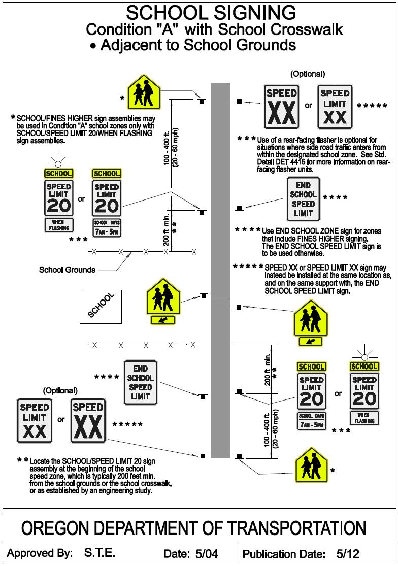
9 School Zone Signing School zone signing as used in Oregon is complicated. In addition to the requirements of the MUTCD, there are ODOT requirements for school signing that are based on Oregon state law. Chapter 7 of the ODOT Sign Policy illustrates school zone signing for several different situations, and is on the internet at: Where there is a 20 mph school speed limit, the ODOT drawings indicate that the END SCHOOL SPEED LIMIT sign is to be used at the end of the school speed zone. If FINES HIGHER signs are used, then an END SCHOOL ZONE sign is to be used at the end of the school speed zone. We did not observe any school zones with FINES HIGHER signs. The use of a SPEED XX sign at the end of the school zone is optional. If it is used, it may be installed either beyond the END SCHOOL SPEED LIMIT sign or on the same post as the END SCHOOL SPEED LIMIT sign. The ODOT policy for marking the end of the school speed limit is consistent with the MUTCD. The MUTCD states (Section 7B.15) that the downstream end of a school speed limit must be marked with an END SCHOOL SPEED LIMIT sign, except that where FINES HIGHER signs are used, the END SCHOOL ZONE sign may be used. The reason for allowing use of the END SCHOOL ZONE sign with higher fines is that the laws of some states (including Oregon) relating to higher fines refer to a school zone rather than a school speed limit. The City uses END SCHOOL ZONE signs even though there are no FINES HIGHER signs, which is inconsistent with the MUTCD. However, it is not apparent to us that there are any significant negative impacts associated with the use of this sign. The City may wish to review this issue and determine whether or not to revise its current school signing policy. Page 9
10 Looking west on Northern Ave showing typical use of an END SCHOOL ZONE sign. We noted that the school zone on Central Dr at Seton does not have signing indicating the end of the school speed zone in either direction. Back-to-Back Signs At the intersection of Danbury and Haller, northbound traffic on Danbury is controlled by STOP signs. There is a DO NOT ENTER sign mounted on the back side of each of the two STOP signs. The MUTCD states that a sign that is mounted back-to-back with a STOP or YIELD sign should stay within the edges of the STOP or YIELD sign. This could be accomplished by installing the DO NOT ENTER signs on separate sign posts or by increasing the size of the STOP signs. Looking south at the intersection of Danbury and Haller. Page 10
11 All-Way Stops There are several all-way STOP intersections that have 4 WAY plaques below the STOP signs. The current version of the MUTCD requires that an ALL WAY plaque be used. When existing 4 WAY plaques are replaced as part of routine maintenance, they should be replaced with ALL WAY plaques. At the intersection of Harlem and Evergreen there is a supplemental STOP sign on a mast arm. The MUTCD requires that an ALL WAY plaque be mounted below each STOP sign at all-way Stops. If the supplemental STOP sign is replaced for maintenance reasons, the City should consider mounting a plaque below the STOP sign. Looking east on Evergreen at Harlem. Lane Lines Page 11
12 We noted some locations on Evergreen Ave where the lane line striping could be improved. Eastbound on Evergreen between 3 rd and Harlem, the right lane becomes a mandatory right-turn lane at Harlem. For this type of situation, in addition to the wide solid lane line, the MUTCD requires a wide dotted lane line (see Figure 3B-11 in the MUTCD). We also noted that the lane-use control sign at this location has extensive cracking on its face and might not have sufficiently reflectivity. Looking east on Evergreen toward Harlem. Page 12
13 Looking east on Evergreen toward Harlem. Eastbound on Evergreen approaching 3 rd, and westbound on Evergreen approaching Division, the lane line is a wide solid line. Unless the City has a reason for the wide solid lines, they should be restriped as normal broken lines to avoid misleading drivers into thinking that there is a mandatory right-turn lane. Bike Lane Striping We noted that, in general, the bike lane striping is consistent with MUTCD standards. The striped westbound bike lane on Evergreen approaching Harlem ends abruptly. Although the existing striping is not inconsistent with the MUTCD, the City might want to consider using a dotted line for the last 50 ft or so of the bike lane to warn bicyclists that the bike lane is ending and that they must merge with motorized traffic. Also, there is a sign that some jurisdictions in Oregon are using to indicate the end of a bike lane which the City might want to consider. Page 13
14 Looking west on Evergreen toward Harlem. Bike Lane Ends sign. Street Name Signs With the new 2009 edition of the MUTCD, the standard lettering for street name signs was changed. The new MUTCD states that for local roads with speed limits of 25 mph or less, the lettering height should be composed of initial upper-case letters at Page 14

15 least 4 inches in height and lower-case letters at least 3 inches in height. For streets with higher speed limits, the upper case should be 6 inches and the lower case 4.5 inches. The change in lettering style was made because studies found that the new style was more readable than lettering that is all upper case. The change in size requirements for speed limits higher than 25 mph was made in recognition of larger numbers of older drivers. It is not necessary to replace any existing street name signs to meet the new standards, but all new or replacement signs should meet the new requirements. We understand that the City is aware of this change and is in the process of revising its signing practices accordingly. An example of the new street name sign standards. Sign borders are optional. Page 15
16 APPENDIX Page 16
17 DISCRETIONARY IMMUNITY Are Your Policy Makers and City Counsel Using it Effectively in the Planning Process? This appendix is based on discussions on risk management relative to highway safety liability. The general concept behind discretionary immunity is that the governing body of a jurisdiction must decide the effective and equitable use of their resources to perform all the necessary activities for which they are responsible, be they social, safety, financial, educational, etc. They plan with aid of legal counsel to order, restrict, or exclude activities from their budget and program to achieve jurisdictional objectives. It may be that city councilors could legally, with the aid of counsel, set a policy to reduce the city s liability for serious safety hazards under discretionary immunity where resources are limited. A county road department may be directed by the County Commission to leave some roads unplowed in the winter, or may be given a list of the priorities on which roads should be plowed and when, recognizing the resources available. The county road department should use its data and expertise to inform and guide the county commissioners to the most cost-effective and equitable program. However, if the final decision and plan resolution are enacted by the county commissioners with guidance from legal counsel, discretionary immunity might be claimed. Another example where discretionary immunity might be employed is where there are numerous low volume unsignalized intersections that do not justify the expense of signing. The county commissioners, together with legal counsel, may consider a policy that certain intersections will not be controlled, even though intersection sight distance may be restricted at some times of the year by crops or snow. STOP signs placed at very low volume intersections are frequently violated, and their use is not cost effective at such sites. Consequently, the use of STOP signs at these sites may not be in the public s best interest. Note: For more information on this concept contact Dave Kramer, Attorney-in-Charge, Trial Division, Oregon Department of Justice. Page 17
18 Page 18
Developed by: The American Traffic Safety Services Association (ATSSA) 15 Riverside Parkway, Suite 100 Fredericksburg, VA
 15 Riverside Parkway, Suite 100 Fredericksburg, VA") Addendum Developed by: The American Traffic Safety Services Association (ATSSA) 15 Riverside Parkway, Suite 100 Fredericksburg, VA 22406-1022 800-272-8772 This material is based upon work supported by
Addendum Developed by: The American Traffic Safety Services Association (ATSSA) 15 Riverside Parkway, Suite 100 Fredericksburg, VA 22406-1022 800-272-8772 This material is based upon work supported by
CHAPTER 6H. TYPICAL APPLICATIONS
 Section 6H.01 Typical Applications Support: CHAPTER 6H. TYPICAL APPLICATIONS Chapter 6G contains discussions of typical temporary traffic control activities. Chapter 6H presents typical applications for
REVOCABLE PERMIT FOR STREET BANNER APPLICATION PACKAGE
 Development Engineering 300 Richards Blvd., 3rd Floor Sacramento, CA 95811 Engineering Services Division REVOCABLE PERMIT FOR STREET BANNER APPLICATION PACKAGE Phone: 916-808-8300 Fax: 916-808-1984 Preparation
Mandan Commission Meeting August 2, 2016 Mandan City Hall
 Mandan-Bismarck Corridor Improvement Study Mandan Commission Meeting August 2, 2016 Mandan City Hall 2014 HDR, Inc., all rights reserved. Mandan Corridors Study Schedule 2015 2016 Study Kick Off August
Updated There is no park access points beyond the limit of the phase I work. roadway to be constructed Viewport has been along full limits of the park
 The signs will be installed as Temporary signs the color (Orange/White) have been added to the plans. Need to specify color to be used for stripes. Closures that may be in place for extended periods need
CHAPTER 1 STANDARD PRACTICES
 CHAPTER 1 STANDARD PRACTICES OBJECTIVES 1) Functions and Limitations 2) Standardization of Application 3) Materials 4) Colors 5) Widths and Patterns of Longitudinal Pavement Marking Lines 6) General Principles
A plan for improved motor vehicle access on Railroad Avenue in Provincetown
 A plan for improved motor vehicle access on Railroad Avenue in Provincetown February 2011 A plan for improved motor vehicle access on Railroad Avenue in Provincetown INTRODUCTION AND PROBLEM IDENTIFICATION
Including Revision 1 dated May 2012 and Revision 2 dated May 2012
 Including Revision 1 dated May 2012 and Revision 2 dated May 2012 Page 634 2009 Edition Notes for Figure 6H-1 Typical pplication 1 Work eyond the Shoulder 1. If the work space is in the median of a divided
AGENDA ITEM 6 D THOMASVILLE ROAD (HERMITAGE BOULEVARD TO LIVE OAK PLANTATION ROAD) ROADWAY SAFETY AUDIT
 ROADWAY SAFETY AUDIT") May 15, 2018 AGENDA ITEM 6 D THOMASVILLE ROAD (HERMITAGE BOULEVARD TO LIVE OAK PLANTATION ROAD) ROADWAY SAFETY AUDIT TYPE OF ITEM: Discussion STATEMENT OF ISSUE The Florida Department of Transportation
May 15, 2018 AGENDA ITEM 6 D THOMASVILLE ROAD (HERMITAGE BOULEVARD TO LIVE OAK PLANTATION ROAD) ROADWAY SAFETY AUDIT TYPE OF ITEM: Discussion STATEMENT OF ISSUE The Florida Department of Transportation
(This page left intentionally blank)
") (This page left intentionally blank) 2011 Edition - Revision 1 Page 553 Section 5A.01 Function CHAPTER 5A. GENERAL 01 A low-volume road shall be defined for this Part of the Manual as follows: A. A low-volume
(This page left intentionally blank) 2011 Edition - Revision 1 Page 553 Section 5A.01 Function CHAPTER 5A. GENERAL 01 A low-volume road shall be defined for this Part of the Manual as follows: A. A low-volume
Off-road Trails. Guidance
 Off-road Trails Off-road trails are shared use paths located on an independent alignment that provide two-way travel for people walking, bicycling, and other non-motorized users. Trails specifically along
CHAPTER 6H. TYPICAL APPLICATIONS
 2006 Edition Page 6H-1 CHAPTER 6H. TYPICAL APPLICATIONS Section 6H.01 Typical Applications Support: Whenever the acronym TTC is used in this Chapter, it refers to temporary traffic control. Standard: The
Appendix C. TRAFFIC CALMING PROGRAM TOOLBOX
 Appendix C. TRAFFIC CALMING PROGRAM TOOLBOX PHASE I...2 Do Not Enter Sign...3 One-Way Sign...4 Turn Prohibition...5 Pavement Markings...6 Speed Monitoring Trailer...7 Neighborhood Speed Watch...8 Police
Date: April 4, Project #: Re: A Street/Binford Street Traffic/Intersection Assessment
 To: Peter Cavanaugh General Electric From: David Bohn, PE Ryan White, PE Date: April 4, 217 Project #: 13421. Re: / Traffic/Intersection Assessment Consistent with the Cooperation Agreement between the
PART 7. TRAFFIC CONTROLS FOR SCHOOL AREAS CHAPTER 7A. GENERAL
 2012 Edition Page 825 Section 7A.01 Need for Standards January 13, 2012 PART 7. TRAFFIC CONTROLS FOR SCHOOL AREAS CHAPTER 7A. GENERAL 01 Regardless of the school location, the best way to achieve effective
Section 9A.07 Meaning of Standard, Guidance, Option, and Support
 2012 Edition Page 895 PART 9. TRAFFIC CONTROLS FOR BICYCLE FACILITIES CHAPTER 9A. GENERAL Section 9A.01 Requirements for Bicyclist Traffic Control Devices 01 General information and definitions concerning
TRAFFIC CONTROL DEVICES FOR LOW VOLUME ROADS
 PART 5. TRAFFIC CONTROL DEVICES FOR LOW VOLUME ROADS TABLE OF CONTENTS Chapter 5A. GENERAL Page Section 5A.1 Function............................................................... 5A-1 5A.2 Application............................................................
TRAFFIC CONTROLS FOR BICYCLE FACILITIES
 PART IX. TRAFFIC CONTROLS FOR BICYCLE FACILITIES A. GENERAL 9A-1 Requirements for Bicyclist Traffic Control Devices Traffic control devices, whether they are intended for motorists or bicyclists, must
CURBSIDE ACTIVITY DESIGN
 5 CURBSIDE ACTIVITY DESIGN This chapter provides design guidance for separated bike lanes adjacent to curbside activities including parking, loading and bus stops. Typical configurations are presented
2009 Manual on Uniform Traffic Control Devices
 2009 Manual on Uniform Traffic Control Devices Tori Brinkly, PE Highway Safety Engineer WFL-FHWA April 20, 2010 Paragraphs are numbered. Standard Statements are bolded. Guidance statements are italicized.
Figure 3B-1. Examples of Two-Lane, Two-Way Marking Applications
 Figure 3B-1. Examples of Two-Lane, Two-Way Marking Applications A - Typical two-lane, two-way marking with passing permitted in both directions B - Typical two-lane, two-way marking with no-passing zones
PART 5. TRAFFIC CONTROL DEVICES FOR LOW-VOLUME ROADS TABLE OF CONTENTS
 2005 Edition Page TC5-1 PART 5. TRAFFIC CONTROL DEVICES FOR LOW-VOLUME ROADS TABLE OF CONTENTS CHAPTER 5A. Section 5A.01 Section 5A.02 Section 5A.03 Section 5A.04 CHAPTER 5B. GENERAL Page Function...5A-1
STREET and UTILITY REPAIRS WORK AREA PROTECTION GUIDE
 STREET and UTILITY REPAIRS WORK AREA PROTECTION GUIDE May 2006 Street and Utility Repairs Work Area Protection Guide TABLE OF CONTENTS 1. Introduction... 1 2. Typical Applications... 11 2.1 Use of Hand-Signaling
Updated There is no park access roadway to be constructed points beyond the limit of along full limits of the park's the phase I work. Phase 1. Revise
 The signs will be installed as Temporary signs the color (Orange/White) have been added to the plans. Need to specify color to be used for stripes. Closures that may be in place for extended periods need
Appendix Work Zone Traffic Control
 ppendix Work Zone Traffic Control The purpose of this appendix is to present basic guidelines for work zone traffic control and to supplement the Highway Work Zone Safety Checklist. This appendix presents
(This page left intentionally blank)
") (This page left intentionally blank) 2011 Edition- Revision 2 Page 813 CHAPTER 9A. GENERAL Section 9A.01 Requirements for Bicyclist Traffic Control Devices 01 General information and definitions concerning
(This page left intentionally blank) 2011 Edition- Revision 2 Page 813 CHAPTER 9A. GENERAL Section 9A.01 Requirements for Bicyclist Traffic Control Devices 01 General information and definitions concerning
2003 Edition Page 2B-1
 2003 Edition Page 2B-1 CHAPTER 2B. REGULATORY SIGNS Section 2B.01 Application of Regulatory Signs Regulatory signs shall be used to inform road users of selected traffic laws or regulations and indicate
Attachment No. 4 Approved by National Committee Council
 Attachment No. 4 Approved by National Committee Council The Signals Technical Committee distributed a technical committee recommendation to sponsors concerning pedestrian hybrid beacons following the January
BLUETT TRAFFIC CALMING ON-SITE MEETING #2 DISCUSSION SUMMARY
 BLUETT TRAFFIC CALMING ON-SITE MEETING #2 DISCUSSION SUMMARY Date: Wednesday, April 11, 2018 Time: 5:30 p.m. to 7:30 p.m. Location: Clague Middle School parking lot Attendees: Public Present: 42 Council
CONSTRUCTION ENCROACHMENT PERMIT APPLICATION AND PROCESSING INSTRUCTIONS
 'HYHORSPHQW (QJLQHHULQJ 5LFKDUGV %OYG UG )ORRU 6DFUDPHQWR &$ Phone: 916-808-8300 Fax: 916-808-1984 (QJLQHHULQJ 6HUYLFHV 'LYLVLRQ CONSTRUCTION ENCROACHMENT PERMIT APPLICATION AND PROCESSING INSTRUCTIONS
Town of Mooresville, North Carolina Neighborhood Traffic Calming and Control Device Policy
 Town of Mooresville, North Carolina Neighborhood Traffic Calming and Control Device Policy Adopted January 6, 2014 Town of Mooresville Development Services Department TOWN OF MOORESVILLE NEIGHBORHOOD TRAFFIC
Pavement Markings (1 of 3)
") Pavement Markings (1 of 3) DESCRIPTION AND DEFINITION Disadvantages Relatively high cost (over typical Crash reduction as yet unknown painted edge line) No tactile effect The STOP AHEAD pavement marking
Pavement Markings (1 of 3) DESCRIPTION AND DEFINITION Disadvantages Relatively high cost (over typical Crash reduction as yet unknown painted edge line) No tactile effect The STOP AHEAD pavement marking
What Is a Complete Street?
 Session 5 Charleen Zimmer, AICP, Zan Associates May 5-7, 2010 What Is a Complete Street? May 2010 5-1 Not a Complete Street More of a Complete Street May 2010 5-2 Benefits of Complete Streets Safety for
On-Street Bicycle Facilities
 On-Street Bicycle Facilities A. General 12B-3 Design Manual Chapter 12 - Sidewalks and Bicycle Facilities 12B - Bicycle Facilities Cyclists have similar access and mobility needs as other transportation
Appendix T CCMP TRAIL TRAFFIC & TRANSPORTATION DESIGN STANDARD
 Appendix T CCMP 3.3.4 TRAIL TRAFFIC & TRANSPORTATION DESIGN STANDARD 3.3.4 Trail Traffic and Transportation Design Multi-use trails have certain design standards, which vary depending on the agency that
INTERSECTIONS AT GRADE INTERSECTIONS
 INTERSECTIONS 1 AT GRADE INTERSECTIONS INTERSECTIONS INTERSECTIONS = INTERRUPTED FACILITIES Definitions and key elements An intersection is defined as an area where two or more roadways join or cross.
MEMORANDUM. Nantasket Road at Kingsley Road Kingsley Road at Sumner Street Kingsley Road at Revere Street Kingsley Road at Kenberma Street
 MEMORANDUM Date: June 28, 2012 To: From: Subject: Mr. Joseph Stigliani, Director of Public Works Kenneth J. Petraglia, P.E., PTOE Greg E. Lucas, P.E., PTOE Kingsley Road Stop Sign Warrant Analysis BETA
Corporate. Report COUNCIL DATE: May 25, 1998 NO: R1500 REGULAR COUNCIL. TO: Mayor & Council DATE: April 27, 1998
 R1500 : Traffic Safety at 25 Avenue and 128 Street Intersection Corporate NO: R1500 Report COUNCIL DATE: May 25, 1998 REGULAR COUNCIL TO: Mayor & Council DATE: April 27, 1998 FROM: General Manager, Engineering
TRAFFIC ACTION PLAN. Laurie Meadows Neighborhood CITY OF SAN MATEO
 TRAFFIC ACTION PLAN Laurie Meadows Neighborhood CITY OF SAN MATEO Draft January 2017 Table of Contents Introduction... 2 The Traffic Forum Process... 5 Neighborhood Traffic Issues... 7 Neighborhood Recommendations
CHAPTER 3A. GENERAL PAGE CHAPTER 3B. PAVEMENT AND CURB MARKINGS PAGE
 Virginia Supplement to the 2009 MUTCD Revision 1 Page TC-3-1 PART 3. MARKINGS CHAPTER 3A. GENERAL PAGE Section 3A.01 Functions and Limitations Section 3A.02 Standardization of Application Section 3A.03
CHAPTER 2B. REGULATORY SIGNS
 CHAPTER 2B. REGULATORY SIGNS Section 2B.01 Application of Regulatory Signs Regulatory signs shall be used to inform road users of selected traffic laws or regulations and indicate the applicability of
Tract or Parcel Project Name PCN Checked By Date
 Tract or Parcel Project Name PCN Checked By Date City of Escondido Public Works Department Signing & Striping Plan Review Checklist The following checklist is a guideline for new CIP and development construction
PART 9. TRAFFIC CONTROLS FOR BICYCLE FACILITIES TABLE OF CONTENTS
 2006 Edition Page TC9-1 PART 9. TRAFFIC CONTROLS FOR BICYCLE FACILITIES TABLE OF CONTENTS SECTIONS CHAPTER 9A. Section 9A.01 Section 9A.02 Section 9A.03 Section 9A.04 Section 9A.05 Section 9A.06 Section
Ohio Department of Transportation Edition of the OMUTCD It s Here!
 Ohio Department of Transportation John R. Kasich, Governor Jerry Wray, Director 2012 Edition of the OMUTCD It s Here! June 6, 2012 Here are reasons why we have a Manual of Uniform Traffic Control Devices
DRAFT Montgomery County Bicycle Master Plan Design Toolkit
 DRAFT Montgomery County Bicycle Master Plan Design Toolkit Fall 2016 Sidepaths Sidepaths are shared use paths located parallel to and within the road right-of-way providing twoway travel for walking, bicycling,
Traffic Signal Phasing Study Summary & Staff Recommendations
 Traffic Signal Phasing Study Summary & Staff Recommendations Consultant Study by Skipper Consulting, Inc. Staff Committee Recommendations by Randy Pewitt, Executive Director of Emergency Mgt. and Safety
Truck Turning Study for Main Street Intersection, Orange
 Truck Turning Study for Main Street Intersection, Orange Franklin Regional Council of Governments September 2015 0 Truck Turning Study for Main Street Intersection, Orange September 2015 Prepared by: Franklin
Draft North Industrial Area-Wide Traffic Plan
 Summary of North Industrial and Hudson Bay Industrial Recommended Improvements Table 1. Summary of s Item Location 1 2 3 4 5 6 7 8 9 10 11 12 Millar Ave north of 51st St Super 8 Motel back lane 400 Block
Signs. signs, signals and road markings. in this chapter
 3 signs, signals and road markings in this chapter Signs regulatory signs school, playground and crosswalk signs lane use signs turn control signs parking signs reserved lane signs warning signs object
MUTCD Part 6G: Type of Temporary Traffic Control Zone Activities
 MUTCD Part 6G: Type of Temporary Traffic Control Zone Activities 6G.01 Typical Applications Each temporary traffic control (TTC) zone is different. Many variables, such as location of work, highway type,
CROSSING GUARD PLACEMENT CONSIDERATIONS AND GAP ASSESSMENT
 CROSSING GUARD PLACEMENT CONSIDERATIONS AND GAP ASSESSMENT Many factors contribute to the need for a Crossing Guard. General federal guidance, provided by the FHWA MUTCD, states that adult crossing guards
2014 FHWA Aging Road User Handbook. Recommendations to Accommodate Aging Pedestrians. Lifesaver National Conference. What is the Handbook?
 2014 FHWA Aging Road User Handbook Recommendations to Accommodate Aging Pedestrians Lifesaver National Conference March 17, 2015 Revised June 2014 1 What is the Handbook? 1998 1st Edition 2001 2nd Edition
Railroad Inspection Procedure Manual
 Railroad Inspection Procedure Manual Railroad Inspection Procedure Manual Table of Contents Introduction... 1 Inspection Report t For orm... 3 Instructions for Completing Inspection Report t For orms...
THE FUTURE OF THE TxDOT ROADWAY DESIGN MANUAL
 THE FUTURE OF THE TXDOT ROADWAY DESIGN MANUAL Kenneth Mora, P.E. (Design Division) 10/10/2017 Table of contents 1 2 Reduction in FHWA design controlling criteria Innovative Intersection Guidance 3-7 8-42
ORANGE COUNTY PUBLIC WORKS TRAFFIC INVESTIGATIONS
 ORANGE COUNTY PUBLIC WORKS TRAFFIC INVESTIGATIONS STAFF REPORT OF: January 6, 2019 SUPERVISORIAL DISTRICT: 5 SUBJECT: LOCATION: INVESTIGATOR: O Neill Drive at Roanoke Drive; Ladera Ranch; TB 922-E6 Clever
Lake Whitney Elementary School
 Lake Whitney Elementary School SCHOOL ROUTE PLAN For LAKE WHITNEY ELEMENTARY SCHOOL LOCATION 18 ORANGE COUNTY Prepared for: ORANGE COUNTY SCHOOL ASSESSMENT PROGRAM ORANGE COUNTY PUBLIC WORKS Traffic Engineering
Roundabout Evaluations in Virginia: US 15/US 50 Gilberts Corner, VA SR 106/SR 634 Prince George County, VA
 Roundabout Evaluations in Virginia: US 15/US 50 Gilberts Corner, VA SR 106/SR 634 Prince George County, VA VDOT & FHWA Roundabout Workshop September 17, 2013 Chris Tiesler, PE Presentation Outline US 15/US
Traffic Control Devices
 533372 Highway Engineering Traffic Control Devices Traffic Control Devices o The media by which traffic engineers communicate with drivers o Every traffic law, regulation, or operating instruction must
Military Road Safety Improvements
 Military Road Safety Improvements 26 th Road North to 31 st Street North SUMMARY OF DATA REVIEW AND PRELIMINARY RECOMMENDATIONS Prepared for: Department of Environmental Services Traffic Engineering and
Chapter 2: Standards for Access, Non-Motorized, and Transit
 Standards for Access, Non-Motorized, and Transit Chapter 2: Standards for Access, Non-Motorized, and Transit The Washtenaw County Access Management Plan was developed based on the analysis of existing
Chapter Twenty-eight SIGHT DISTANCE BUREAU OF LOCAL ROADS AND STREETS MANUAL
 Chapter Twenty-eight SIGHT DISTANCE BUREAU OF LOCAL ROADS AND STREETS MANUAL Jan 2006 SIGHT DISTANCE 28(i) Chapter Twenty-eight SIGHT DISTANCE Table of Contents Section Page 28-1 STOPPING SIGHT DISTANCE
Traffic Signs and Signals
 CHAPTER FOUR Traffic Signs and Signals Traffic signs control traffic flow, making streets and highways safer for drivers, bicyclists and pedestrians. These signs, which are posted by the Indiana Department
Lee s Summit Road Improvement Study Public Open House June 7, 2007 Summary of Comment Card Responses
 Lee s Summit Road Improvement Study Public Open House June 7, 2007 Summary of Comment Card Responses Introduction At the Lee s Summit Road Improvement Study Public Open House held Thursday, June 7, 2007
City of Roseville Section 13 Design Standards. _Bikeways January 2016 SECTION 13 BIKEWAYS
 SECTION 13 BIKEWAYS 13-1 GENERAL The City of Roseville bikeway standards are designed to insure that transportation and recreational bikeways are constructed in a manner that would provide a safe and comfortable
Seattle Department of Transportation (SDOT) Preliminary Responses to Madison-Miller Community List of Site-Specific Concerns
 Preliminary Responses to Madison-Miller Community List of Site-Specific Concerns") Seattle Department of Transportation (SDOT) Preliminary Responses to Madison-Miller Community List of Site-Specific Concerns Background In July 2002 SDOT staff met with a small group of community residents
Seattle Department of Transportation (SDOT) Preliminary Responses to Madison-Miller Community List of Site-Specific Concerns Background In July 2002 SDOT staff met with a small group of community residents
ATTACHMENT NO. 11. RRLRT No. 2. Railroad / Light Rail Transit Technical Committee TECHNICAL COMMITTEE: Busway Grade Crossings STATUS/DATE OF ACTION
 ATTACHMENT NO. 11 RRLRT No. 2 TECHNICAL COMMITTEE: TOPIC: Railroad / Light Rail Transit Technical Committee Busway Grade Crossings STATUS/DATE OF ACTION RRLRT TC Draft: 06/23/2011 RRLRT TC Approval: 06/27/2014
Chapter 4 On-Road Bikeways
 Chapter 4: 4-1.0 Introduction On-Road Bikeways This chapter provides guidelines to help select and design safe on-road bikeways. On-road bikeways include bicycle lanes, shared lanes, shoulders, and wide
TRAFFIC CONTROLS FOR BICYCLE FACILITIES
 Part 9. TRAFFIC CONTROLS FOR BICYCLE FACILITIES TABLE OF CONTENTS Chapter 9A. GENERAL Page Section 9A.1 Requirements for Bicyclist Traffic Control Devices............................. 9A-1 9A.2 Scope.................................................................
The 2009 Manual on Uniform Traffic Control Devices (MUTCD) (Brief) Highlights for Arizona Practitioners. Arizona Department of Transportation
 (Brief) Highlights for Arizona Practitioners. Arizona Department of Transportation") The 2009 Manual on Uniform Traffic Control Devices (MUTCD) (Brief) Highlights for Arizona Practitioners Arizona Department of Transportation New 2009 MUTCD 9 Parts (down from 10 in 2003) 816 pages (up
The 2009 Manual on Uniform Traffic Control Devices (MUTCD) (Brief) Highlights for Arizona Practitioners Arizona Department of Transportation New 2009 MUTCD 9 Parts (down from 10 in 2003) 816 pages (up
Active Transportation Facility Glossary
 Active Transportation Facility Glossary This document defines different active transportation facilities and suggests appropriate corridor types. Click on a facility type to jump to its definition. Bike
Oregon Supplement to the Manual on Uniform Traffic Control Devices. Adopted July 2005 by OAR
 Oregon Supplement to the Manual on Uniform Traffic Control Devices Adopted July 2005 by OAR 734-020-0005 2003 Edition Oregon Supplement to the MUTCD Page 2 INTRODUCTION Traffic control devices installed
Accommodating Pedestrians in the Work Zone
 Accommodating Pedestrians in the Work Zone Guidance for Section C Plan Preparers Some impacts cannot be avoided and those impacts apply to residents, businesses, motorists, and pedestrians alike. However,
Proposed changes to Massachusetts MUTCD Supplement
 Proposed changes to Massachusetts MUTCD Supplement John F. Carr National Motorists Association October 24, 2002 This document contains recommendations as to the contents of the Massachusetts MUTCD supplement
National Committee on Uniform Traffic Control Devices RWSTC RECOMMENDATION FOLLOWING SPONSOR COMMENTS
 1 2 3 ATTACHMENT NO. 1 RW No. 1, Jan 2012 4 5 6 7 8 9 10 11 12 13 14 15 16 17 18 19 20 21 22 23 24 25 26 27 28 29 30 31 32 33 34 35 36 37 38 39 40 41 National Committee on Uniform Traffic Control Devices
Attachment No. 13. National Committee on Uniform Traffic Control Devices RWSTC RECOMMENDATION FOLLOWING SPONSOR COMMENTS
 1 2 3 4 Attachment No. 13 5 6 7 8 9 10 11 12 13 14 15 16 17 18 19 20 21 22 23 24 25 26 27 28 29 30 31 32 33 34 35 36 37 38 39 40 41 42 43 RWSTC agenda item IV. 2 June 2011 National Committee on Uniform
SAN FRANCISCO MUNICIPAL TRANSPORTATION AGENCY
 THIS PRINT COVERS CALENDAR ITEM NO. : 10.3 DIVISION: Sustainable Streets Division BRIEF DESCRIPTION: SAN FRANCISCO MUNICIPAL TRANSPORTATION AGENCY Approving traffic and parking modifications to install
Typical Cross Section: DOWNTOWN (Observer Highway - 8th Street)
") Typical Cross Section: DOWNTOWN (Observer Highway - 8th Street) DRAFT SEPTEMBER 23, 14 1 Washington Street Typical Block Downtown Typical Block: DOWNTOWN (Observer Highway - 8th Street) New crosswalks
Typical Cross Section: DOWNTOWN (Observer Highway - 8th Street) DRAFT SEPTEMBER 23, 14 1 Washington Street Typical Block Downtown Typical Block: DOWNTOWN (Observer Highway - 8th Street) New crosswalks
ROAD SAFETY AUDIT. May 18, Prepared For: MassDOT. On Behalf Of: Town of Milford
 ROAD SAFETY AUDIT East Main Street (Route 16) at Medway Road (Route 109), East Main Street (Route 16) at Quarry Square Driveways, East Main Street (Route 16) at Beaver Street/ Fortune Boulevard Town of
MINNEAPOLIS PARK & RECREATION BOARD DRAFT TRAIL DESIGN STANDARDS FOR: SIGNS AND PAVEMENT MARKINGS
 MINNEAPOLIS PARK & RECREATION BOARD DRAFT TRAIL DESIGN STANDARDS FOR: SIGNS AND PAVEMENT MARKINGS October 14, 2014 CHANGE LOG Additions and changes to this document should be summarized on this page and
Orange Center Elementary School
 Drag and drop pic and stretch/crop to the limits of the blue rectangle (delete this text box) Orange Center Elementary School Drag and drop pic and stretch/crop to the limits of the blue rectangle (delete
Guidance. ATTACHMENT F: Draft Additional Pages for Bicycle Facility Design Toolkit Separated Bike Lanes: Two-Way to One-Way Transitions
 ATTACHMENT F: Draft Additional Pages for Bicycle Facility Design Toolkit Separated Bike Lanes: Two-Way to One-Way Transitions This treatment provides a transition from two-way separated bike lanes to one-way
Geometric Design Tables
 Design Manual Chapter 5 - Roadway Design 5C - Geometric Design Criteria 5C-1 Geometric Design Tables A. General The following sections present two sets of design criteria tables - Preferred Roadway Elements
PLACEMENT OF SIGNS RECOMMENDED PRACTICES SUB-SECTION
 Page 1 of 6 RECOMMENDED PRACTICES PART SECTION SUB-SECTION HIGHWAY SIGNS GENERAL General Proper positioning of signs is an important element in the overall control of traffic within a roadway network.
Appendix A. Knoxville TPO Greenway Signage Guidelines. Appendix A: Knoxville TPO Greenway Signage Guidelines Knox to Oak Ridge Greenway Master Plan
 Appendix A Knoxville TPO Greenway Signage Guidelines 75 Overview: Adequate signing and marking are essential on shared-use paths, especially to alert bicyclists to potential conflicts and to convey regulatory
Peer Review of Highlands Neighborhood Traffic and Pedestrian Safety Plan
 FINAL REPORT March 14, 2017 Prepared for: Ada County Highway District Prepared by: SIX MILE ENGINEERING, PA Executive Summary The (Highlands Safety Plan) developed by the Ada County Highway District (ACHD)
5. RUNNINGWAY GUIDELINES
 5. RUNNINGWAY GUIDELINES These guidelines should be considered collectively when making runningway decisions. A runningway is the linear component of the transit system that forms the right-of-way reserved
Public Works Committee Meeting Richard E. Mastrangelo Council Chamber November 20, 2017
 Public Works Committee Meeting Richard E. Mastrangelo Council Chamber November 20, 2017 Purpose of Meeting Why are we here? Project Recap/Updates Project Limits/Segments Road Diet Concept Lessons Learned
Traffic Circulation Study for Neighborhood Southwest of Mockingbird Lane and Airline Road, Highland Park, Texas
 ARIZONA TEXAS NEW MEXICO OKLAHOMA February 13, 2015 Mr. Meran Dadgostar P.E., R.S. Town of Highland Park 4700 Drexel Dr. Highland Park, Texas 75205 Re: Traffic Circulation Study for Neighborhood Southwest
CHAPTER 2G. PREFERENTIAL AND MANAGED LANE SIGNS
 2011 Edition - Revision 2 Page 275 Section 2G.01 Scope CHAPTER 2G. PREFERENTIAL AND MANAGED LANE SIGNS 01 Preferential lanes are lanes designated for special traffic uses such as high-occupancy vehicles
C/CAG. Sunnybrae Elementary School Walking and Bicycling Audit. San Mateo-Foster City School District JUNE 2013
 Sunnybrae Elementary School Walking and Bicycling Audit JUNE 2013 San Mateo-Foster City School District C/CAG City/County Association of Governments of San Mateo County SUNNYBRAE ELEMENTARY SCHOOL WALKING
10.0 CURB EXTENSIONS GUIDELINE
 10.0 CURB EXTENSIONS GUIDELINE Road Engineering Design Guidelines Version 1.0 March 2017 City of Toronto, Transportation Services City of Toronto Page 0 Background In early 2014, Transportation Services
CITY OF SARATOGA SPRINGS PEDESTRIAN CROSSING TOOLBOX
 CITY OF SARATOGA SPRINGS PEDESTRIAN CROSSING TOOLBOX This toolbox is to be used to guide pedestrian crossing improvements within the City of Saratoga Springs. Details for each crossing type are provided.
Swamp Road Residents Study
 Swamp Road Residents Study SRRG Meeting with PennDot and Elected Officials Newtown and Wrightstown, PA April 25, 2008 Newtown Township Section of Swamp Road Limited Public Funds No reconstruction of a
ADA on Construction. Guidance for Section C Plan Preparers
 ADA on Construction Guidance for Section C Plan Preparers Some impacts cannot be avoided and those impacts apply to residents, businesses, motorists, and pedestrians alike. However, good planning can minimize
TRAFFIC CALMING POLICY & PROCEDURES
 TRAFFIC CALMING POLICY & PROCEDURES AS ADOPTED BY MONTCLAIR TOWNSHIP COUNCIL AUGUST 4, 2009 TABLE OF CONTENTS 1. INTRODUCTION... 2 Purpose... 2 Traffic Calming Definition... 2 Statement Of Township Council
Multi-Modal Traffic Analysis. Parisi and Associates
 Mill Valley to Corte Madera Bicycle and Pedestrian Corridor Study Appendix D: Multi-Modal Traffic Analysis Prepared by Parisi and Associates August 2009 Appendix D - Multi-Modal Traffic Analysis Table
SR 53 Corridor Study. Final Report Presentation. Friday, October 3, :00 AM to noon
 SR 53 Corridor Study Final Report Presentation Friday, October 3, 2014 10:00 AM to noon SR 53 Corridor Study Final Report Presentation Study Purpose: Investigate safety improvements along the SR 53 corridor
Broadway Street Pedestrian Safety Study Cass Street to 700 Feet North of Randall Avenue
 Broadway Street Pedestrian Safety Study Cass Street to 700 Feet North of Randall Avenue Prepared for: City of De Pere, Wisconsin Prepared by: June, 2017 Broadway Street Pedestrian Safety Study Cass Street
Bowman-Melton Associates, Inc. june 2011
 2011 dallas bike plan ADDENDUM Bowman-Melton Associates, Inc. Complete Streets Initiative Design and policy guidance june 2011 2 2011 Dallas Bike Plan Complete Streets Initiative Design and Policy Guidance
$ 12" $#&%$ 86.) *1! *1 /3 )00, , (1* Neighborhood Traffic Calming Part 3 Solutions Bradley William Yarger, P.E.
 *1! *1 /3 )00, , (1* Neighborhood Traffic Calming Part 3 Solutions Bradley William Yarger, P.E.") $ 12" $#&%$ 86.)3+5+2 714 *1! *1 /3 )00,12 3.+ -0127 1, (1* Neighborhood Traffic Calming Part 3 Solutions by Bradley William Yarger, P.E. It is extremely tempting to jump to this step of the process thinking
$ 12" $#&%$ 86.)3+5+2 714 *1! *1 /3 )00,12 3.+ -0127 1, (1* Neighborhood Traffic Calming Part 3 Solutions by Bradley William Yarger, P.E. It is extremely tempting to jump to this step of the process thinking