Pull the gate towards you and ride through. The third gate takes you onto Hound House Road. Watch out for traffic. 4
|
|
|
- Matthew Paul Doyle
- 6 years ago
- Views:
Transcription


1 PEASLAKE TO FARLEY HEATH AND WINTERFOLD 12k CIRCULAR ROUTE 2HRS GU5 9QW This interesting trail takes you across a variety of terrain, from the sandstone of Pitch Hill, across open farmland with fabulous views to St Martha s, over sandy heathland at Farley Green and back on long straight bridleways through Winterfold Forest. The trail begins at Walking Bottom Car Park, GU5 9QW. This spacious car park is a very busy mountain biking hub so best to avoid weekends. The bikes will not be going your way though! 1 3 Start at Walking Bottom car park in Peaslake, 1 turning left up the tarmac road and taking the first sharp righthand hairpin along Lawbrook Lane. After about 500m turn left onto a bridleway which takes you through farmland. 2 Pull the gate towards you and ride through. The third gate takes you onto Hound House Road. Watch out for traffic. 4 4 Go left for 50m.Then take the bridleway on the right at Knowle Grange There are three spring loaded gates with high lever catches between the fields. 3


2 This path takes you along a narrow track bearing right between fields and woodland to Lockhurst Hatch Farm. Go through the farm gate, closing with the rope loop. Ride through the farm down the drive to the lane and turn left up the lane, Lockhurst Hatch. 6 6 This will take you all the way to a T junction with Shophouse Lane in Farley Green signed towards Albury, Guildford. 7 Turn left along the road for 50m and then turn right, taking the left of the two tracks. 9 9 Continue along the track till you come to cottages on the right and take the little slip road on the left across the grass Turn right and ride along the lane into Farley Green Village. Ride across the grass next to the road and bear left along the sandy drive till you hit Farley Heath Road. 8 8 You are looking for a very narrow path through the bushes 90 deg to the left, just before the grass peters out, that will go all the way to Farley Heath car park


3 This long track goes gently uphill and you just follow it, keeping straight and crossing a series of junctions until it reaches the Romano Celtic Temple at Farley Heath Car Park. A lovely sandy trail. 12 (You could start the ride from here if parking is easier.) Turn left and go past Mayor House Livery Stables, keeping on the main track. Cross over Ride Lane BOAT and keep going until the now metalled drive joins Shophouse Lane Ride across the car park keeping parallel with the road and cross the road at the far exit. Take the bridleway immediately facing you. 13 Turn left along the lane until the road makes a sharp 90 deg turn to the left Keep going throught the woods until you come to a T junction with a hard sand driveway There is a brick Post Box on the right and just past it is a narrow bridlepath dipping steeply downhill, next to a wider track marked Row Lane. Take the path - it s quite short


4 Turn right when it meets the nice firm track going along the valley bottom. 18 There is a muddy pond behind the fence on your right by the junction! 18 You are now entering Winterfold Forest, on a well marked bridleway. The trail takes you for 1.5k right the way to Jelley s Hollow, so just follow the blue signs as the bridlepath crosses several forest roads. Along the way you will come across a magical valley, where the old Forestry Commission plantation has been felled. It s stunning! The track brings you to a lane with the dramatic gorge of Jelley s Hollow immediately opposite. 20 Without going onto the road, though, turn left and up the main path past the row of little stumps This track has open Hurtwood heathland to the left and woods to the right. It roughly follows the lane. After about 700m it goes past a car park immediately on your right Keep going through the woods following the blue bridleway markers. and shortly afterwards dips down into another car park by the junction at the top of Horseblock Hollow. 23


5 23 There is a bridleway fingerpost pointing down the hill to the left. Take this path for 1.5k. It s a bit stony to start with. Keep going through the wooden barrier Carry on down the hill, crossing over the forest road and following the bridleway markers. 25 This path goes through the woods past mountain bike trails and comes out on the drive opposite Bentley s Copse, the outdoor adventure centre, on Hound House Road Cross the road and follow the track past the centre on the left, down the hill and up the other side. Keep straight, cross a big fire road on your right, and carry on until you come out on Hurtwood House drive leading to Walking Bottom lane You will go past two of Winterfold s spring-fed ponds known as wells, and head uphill through another wooden gateway Cross the lane, take the path opposite 29 and go downhill and bear left to emerge back in Walking Bottom Car Park. 29
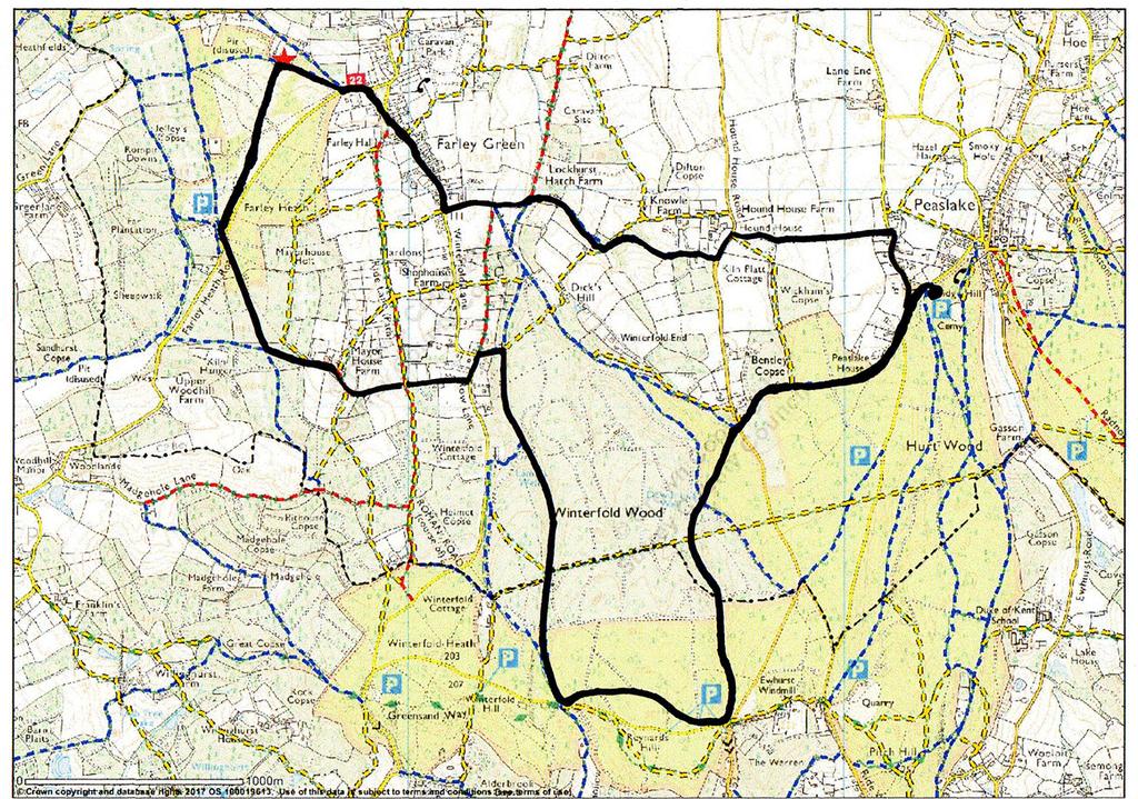
6
Winterfold Wood. point your feet on a new path. In Brief
 point your feet on a new path Winterfold Wood Distance: 8½ km=5¼ miles Region: Surrey Author: Schwebefuss Refreshments: Windmill Inn, Peaslake after the walk moderate walking with many gradients Date written:
Shere Heath and the Hurtwood
 point your feet on a new path Shere Heath and the Hurtwood Distance: 15¾ km=9¾ miles Region: Surrey Author: Schwebefuss Refreshments: Little London moderate-to-easy walking Date written:10-jul-2009 Date
NEWLANDS CORNER AND ST MARTHAS
 NEWLANDS CORNER AND ST MARTHAS 10k CIRCULAR ROUTE 2½-3HRS GU4 8SE From Newlands Corner on the North Downs just outside Guildford, you can enjoy one of the most beautiful panoramas of quintessential English
THE WELLDIGGERS ARMS, HESWORTH AND FITTLEWORTH TRAIL
 THE WELLDIGGERS ARMS, HESWORTH AND FITTLEWORTH TRAIL 5.5 miles Circular 3 hours 041017 Challenging Terrain A 300-year-old pub turned country-inn on the edge of the South Downs National Park, The Welldiggers
LDWA SOUTH DOWNS MARATHON
 AHD ahead SDW South Downs Way BL/BR bear left/bear right TL/TR turn left/turn right SP signpost/fingerpost X cross LEG 1 - EAST DEAN to WP1 NORTON GR 470019. Open 1030 to 1300. 9.6 miles. 1.1 From village
Hammer Vale and Linchmere Common
 point your feet on a new path Hammer Vale and Linchmere Common Distance: 9 km=5½ miles or 6 km=3¾ miles easy walking with one steep section Region: Hampshire, West Sussex Author: Botafuego Refreshments:
LDWA SOUTH DOWNS MARATHON 13 th MAY 2018
 AHD ahead SDW South Downs Way BL/BR bear left/bear right TL/TR turn left/turn right X cross LEG 1 - EAST DEAN to WP1 NORTON GR 470019. Open 1030 to 1300. 9.7 miles. 1.1 From village hall TL and walk to
BALCOMBE AND ARDINGLY RESERVOIR, WEST SUSSEX
 BALCOMBE AND ARDINGLY RESERVOIR, WEST SUSSEX 7 miles Circular 4 hours 080816 Challenging Terrain Hi, I'm Luke and this is my West Sussex Weekends walk It's a 7 mile loop from Balcombe rail station, taking
Greensand Hills from the South
 point your feet on a new path Greensand Hills from the South Distance: 19 or 20 km=12 or 12½ miles moderate walking with two shorter options of 13 km=8 miles each Region: Surrey Author: Schwebefuss Refreshments:
9.5 km Circular 3 hours
 SILENT POOL AND ST MARTHA S HILL Challenging Terrain A 9.5km (6 mile) circular walk in the Surrey Hills, visiting a number of popular attractions including Silent Pool, a stretch of the North Downs Way,
HARDMOORS 26.2 WHITE HORSE HALF ROUTE DESCRIPTION - 018
 HARDMOORS 26.2 WHITE HORSE HALF ROUTE DESCRIPTION - 018 Follow Cleveland Way, keeping to the left hand path (right path is a bike trail) Ignoring any turnings to the left or right At path junction (after
Distance: 15 km=9 miles, with 2 optional diversions 1-2 km each easy walking
 point your feet on a new path Hascombe from Afar Distance: 15 km=9 miles, with 2 optional diversions 1-2 km each easy walking Region: Surrey Author: Schwebefuss Refreshments: Hascombe Date written: 9-may-2010
North Downs Way Monster Alternative North Downs Way Double Walk Box Hill or Dorking to Newlands Corner or Guildford
 point your feet on a new path North Downs Way Monster Alternative North Downs Way Double Walk Box Hill or Dorking to Newlands Corner or Guildford Distance: 0 or 6 km=8½ or 6 miles (by rail) or 6 km=½ miles
9.5 km Circular 3 hours
 MEDIEVAL WAVERLEY Challenging Terrain A 6 mile (9.5km) undulating circular walk from Tilford village passing close to The Sands village and the historic ruins of Waverley Abbey. From the top of Crooksbury
Distance: 14 km=8½ miles or 7 km=4½ miles easy-to-moderate walking
 point your feet on a new path Normandy Distance: 14 km=8½ miles or 7 km=4½ miles easy-to-moderate walking Region: Surrey Author: Botafuego Refreshments: Pirbright, Ash date written: 20-feb-2012 date revised:
Bagshot Heath and Swinley Forest
 point your feet on a new path Bagshot Heath and Swinley Forest Distance: 13 km=8 miles Region: Berkshire, Surrey Author: Botafuego Refreshments: Forest Look Out, Bagshot easy walking Date written: 17-feb-2013
Danbury Words and pictures by Laurie Page of the Public Rights of Way team at Essex County Council.
 Danbury Words and pictures by Laurie Page of the Public Rights of Way team at Essex County Council. An undulating walk from Danbury village to the bluebells at the National Trust property of Blakes Wood.
The Mendip Way. Route Directions and Maps Wells to Frome
 The Mendip Way Route Directions and Maps Wells to Frome Website: www.mendiphillsaonb.org.uk Email: mendip@mendiphillsaonb.org.uk Facebook & Twitter: @MendipHillsAONB Phone: 01761462338 1 Wells to Shepton
Follow the Lantern Way clockwise from Dursley Town Hall through Cam & Coaley to Uley and back to Dursley (about 14 miles)
") According to the Rev Kilvert's diary of 1873, couples on their way to evening services in winter followed a practical though unusual local tradition: "My Mother says that at Dursley, when ladies and gentlemen
According to the Rev Kilvert's diary of 1873, couples on their way to evening services in winter followed a practical though unusual local tradition: "My Mother says that at Dursley, when ladies and gentlemen
Bakewell Club Site - Robin Hood's Stride
 Bakewell Club Site - Robin Hood's Stride Camping and Caravanning Route Summary A circular walk with fabulous views winding it's way through the beautiful White Peak scenery. Points of interest include
CHINTHURST HILL AND THE GRANTLEY ARMS, SURREY
 CHINTHURST HILL AND THE GRANTLEY ARMS, SURREY 4 miles Circular 2 hours 110417 Challenging Terrain A 4 mile (can be shortened to 3 miles) circular pub walk near Wonersh in Surrey. The walk begins with an
WETHERBY CIRCULAR by Tania Dickinson
 WETHERBY CIRCULAR by Tania Dickinson This walk in lower Wharfedale includes a disused railway line at the beginning and riverside at the end, with parkland, fields, woodland and villages in between. Distance
Distance: 11 km=7 miles or 8 km=5 miles easy walking with two short steepish sections
 point your feet on a new path Common Distance: km=7 miles or 8 km=5 miles easy walking with two short steepish sections Region: Surrey Author: Schwebefuss Refreshments: Chart, Moorhouse Date written: 7-dec-05
How to get there. Respect - Protect - Enjoy
 How to get there Driving: Postcode is OX49 5HL with a car park for customers Nearest station: Henley on Thames station is 9.5 miles away. We re delighted to present three circular walks all starting and
Distance: 9½ km=5¾ miles moderate walking or two walks of 4¼ km=2¾ miles and 6½ km=4 miles
 point your feet on a new path White Hill, Headley Distance: 9½ km=5¾ miles moderate walking or two walks of 4¼ km=2¾ miles and 6½ km=4 miles Region: Surrey Author: Fusszweig Refreshments: Headley Date
Ashdown Forest, Fairwarp Rock Wood and Purple Heather
 point your feet on a new path Ashdown Forest, Fairwarp Rock Wood and Purple Heather Distance: 14 km=9 miles or 2 walks of 10 km=6 miles and 8 km=5 miles moderate walking Region: East Sussex Author: Stivaletti
9.5 km Circular 3 hours
 RANMORE CIRCULAR A 6 mile (9.5km) circular walk from Boxhill and Westhumble Station in the village of Westhumble, passing through part of the Polesden Lacey Estate, Ranmore Common and Denbies Vineyard.
West Marden and Stansted Forest
 point your feet on a new path West Marden and Forest Distance: 3½ km=8½ miles easy walking with optional ½ km=½ miles extension to Rowlands Region: West Sussex Author: Hautboy Refreshments: West Marden,
Dragonflies and a Church-on-the-Hill Chantries, Shalford, Blackheath
 point your feet on a new path Dragonflies and a Church-on-the-Hill Chantries, Shalford, Blackheath Distance: 16 km=10 miles Region: Surrey Author: Schwebefuss Refreshments: Shalford (choice of two) easy-to-moderate
Route: Skewsby Foulrice Stearsby
 Route: Skewsby Foulrice Stearsby Distance: 7 miles Map: Explorer: 300 Howardian Hills & Malton Start (OS ref): SE625710 Park in the village of Skewsby. Walk east out of the village to the T-Junction and
Beautiful Walks from the Blue Ball Inn
 Walk No. 7 COAST AND VALLEY WALK Countisbury, Glenthorne, County Gate, Brendon, Rockford and Wilsham 10 MILES APPROX. Walking time 5 hours approx. (not including breaks)> OS Sheet 64/74 Lynton and Lynmouth.
THE DOG AND DUCK HAREWOODS ESTATE TRAIL. 6 Miles Circular 3 hours. Getting there. Walk Sections
 THE DOG AND DUCK HAREWOODS ESTATE TRAIL Moderate Terrain A 6 mile circular pub walk from the Dog and Duck in Outwood, Surrey. The Dog and Duck is a delightful pub where everyone is made welcome. From walkers
Harlington - Sharpenhoe - Pulloxhill
 Harlington - Sharpenhoe - Pulloxhill ID: 3676, Distance: 8 miles, Height gain: 140 Metres, Map: Explorer 193 Luton & Stevenage, Contributor: Dennis Jeanes Duration: 3 Hours 27 Mins Features Church,Great
Ashdown Forest, Church Hill, Withyham Ravines and Parkland
 point your feet on a new path Ashdown Forest, Church Hill, Withyham Ravines and Parkland Distance: 6½ km=0 miles or ½ km=8 miles, easy walking + an optional extra km= miles Region: East Sussex Author:
Hascombe and Winkworth Arboretum Downs Link Path, Smithbrook Kilns
 point your feet on a new path Hascombe and Winkworth Arboretum Downs Link Path, Smithbrook Kilns Distance: 18 km=11 miles Region: Surrey Author: RDC easy walking Date written: 7-may-2016 Last update: 30-aug-2018
Puttenham and the Welcome Woods
 point your feet on a new path and the Welcome Woods Distance: 15 km=9 miles easy walking or 2 shorter walks of 5½ km=3 miles and 12½ km=7½ miles Region: Surrey Author: Schwebefuss Refreshments: or picnic
Farley Heath, Wonersh and Blackheath
 point your feet on a new path Farley Heath, Wonersh and Blackheath Distance: 12 km=7½ miles or 9½ km=6 miles easy-to-moderate walking Region: Surrey Author: Fusszweig Refreshments: Shamley Green, Wonersh
10 km Circular 3 hours
 FRIMLEY AND FRIMLEY GREEN 10 km Circular 3 hours Easy Terrain 250716 A 10km (6 mile) circular walk exploring the canal towpath, riverside path, woodland, heath and small settlements around Frimley in Surrey.
Distance: 5 km=3 miles or 4½ km=2¾ miles or 3½ km=2 miles
 point your feet on a new path Vann Lake Distance: 5 km=3 miles or 4½ km=2¾ miles or 3½ km=2 miles Region: Surrey Author: Schwebefuss Refreshments: Ockley easy walking Date written: 12-feb-2011 Date revised:
Walk: NOC 08 Location: Cym Glyn near Brecon
 33 Walk: NOC 08 Location: Cym Glyn near Brecon Directions: Not easy to find at all. Go to Libanus, then head towards Brecon on the A470. Take minor C road single track lane first right as you come out
The North Pennines from near Langwathby
 3.6 Langwathby to Armathwaite Map panel?? Distance 12.7 miles (20.5 km) Terrain farm, woodland and riverside paths; some potentially muddy tracks; a few short sections of road Grade gently undulating Food
Hindleap and Vachery Ashdown Forest, Chelwood Gate, Forest Row
 point your feet on a new path Hindleap and Vachery Ashdown Forest, Chelwood Gate, Forest Row Distance: 5 km=9½ miles Region: East Sussex Author: Stivaletti Refreshments: Chelwood Gate, Forest Row Map:
Chipstead to Kingswood walk
 Saturday Walkers Club www.walkingclub.org.uk Chipstead to Kingswood walk Ancient woodland, open downs and farmland in London's Green Belt Length OS Map Toughness Features Main Walk: 15½ km (9.6 miles).
Walk Description. Directions
 Title: Saffron Trail: Battlesbridge to Chelmsford Distance: 14¾ miles Time taken: 6 hours Start Point: Outside the Barge Inn, Battlesbridge OS Explorer Map: 175 & 183 Grid Ref.: TQ 780 947 Transport: Rail:-
EAST GRINSTEAD AND THE HIGH WEALD, WEST SUSSEX
 EAST GRINSTEAD AND THE HIGH WEALD, WEST SUSSEX 7 miles Circular 3.5 hours 301015 Challenging Terrain Hi, I'm Tom and this is my West Sussex Weekends walk. I live and work in London but often head out of
Blackheath and Shamley Green
 point your feet on a new path and Shamley Green Distance: 14 km=9 miles Region: Surrey Author: Schwebefuss Refreshments:, Shamley Green easy walking with one climb Date written: 27-jun-2009 Date revised:
Although the majority of these walks are around country lanes you should still follow the Country Code:-
 With the update of the Parish Plan was a request for details of any Walks around Pillaton The following pages give several walks that I and my wife have done for many years. Please be aware that NONE OF
Dorridge & District Residents Association A Walk Along The Green Belt From Dorridge to Catherine-de-Barnes
 Dorridge & District Residents Association A Walk Along The Green Belt From Dorridge to Carine-de-Barnes The starting section of this walk through open fields would be destroyed by building of motorway
Stokenchurch. Bluebell Woods, Bomber Memorial, Red Kites, Getty s Cricket Ground, Nature Reserve
 Stokenchurch Bluebell Woods, Bomber Memorial, Red Kites, Getty s Cricket Ground, Nature Reserve Bomber Memorial The best time to visit Cowleaze Wood is in the spring when there is a memorable display of
THE PONTON PLOD - 27 MILE ROUTE
 THE PONTON PLOD - 27 MILE ROUTE Emergency Phone Number 07771 813514 Abbreviations: BW Bridleway X Cross immd immediately FP Footpath TL Turn left L Left thro through KG Kissing Gate TR Turn right R Right
Sweetwater and the Holy Well Witley Station, Hambledon, Chiddingfold
 point your feet on a new path Sweetwater and the Holy Well Witley Station, Hambledon, Chiddingfold Distance: 7½ km= miles Region: Surrey Author: Schwebefuss Refreshments: Hambledon, Chiddingfold easy walking
How to get there. Respect - Protect - Enjoy
 How to get there Driving: Postcode is RG9 5PF and there is a car park just across from the pub. Nearest station: Henley-on-Thames station is 5.6 miles away. We re delighted to present three circular walks
West Hoathly and Gravetye Manor
 point your feet on a new path West Hoathly and Gravetye Manor Distance: 8½ km=5½ miles or 7 km=4½ miles easy walking with one gradient Region: West Sussex Author: Sackboot Refreshments: West Hoathly Date
Poundgate and The Hurstwood
 point your feet on a new path Poundgate and The Hurstwood Distance: 11 km=7 miles Region: East Sussex Author: Stivaletti Refreshments: High Hurstwood easy walking Date written: 24-jul-2016 Last update:
Dyrham and Hinton Parish Walks
 Dyrham and Hinton Parish Walks A series of five walks in the parish, exploring most of the public footpaths. By John Miller Each walk is described in detail, with a complete map, to provide a handy guide
Bonnie Prince Charlie Walk
 Bonnie Prince Charlie Walk A waymarked route from Ashbourne to Derby to celebrate the 60th anniversary (1995) of the formation of the Ramblers' Association. This route follows the general direction of
The Alice Lisle Walking Guide
 The Alice Lisle Walking Guide Using some local knowledge we have been able to design some great walks starting and finishing at the Alice Lisle. If you re planning a group walk, please get in contact with
Guildford Circular via Chantries Hill
 Main walk and option b) last checked Chilworth options last checked Shalford options last checked 28 October 2017 16 January 2018 28 October 2017 Document last updated: 15 March 2018 This document and
Parks, green routes, river, churches, heath, views, historic town
 point your feet on a new path Hendon to Distance: 8½ km=5½ miles Region: Greater London Author: Thwelder Refreshments: Hendon, Map: Explorer 173 (London North) or A-Z, both optional easy walking Date written:
Fernhurst and the Temple of the Winds
 point your feet on a new path Fernhurst and the Temple of the Winds Distance: 8 km=5 miles Region: West Sussex Author: Hautboy Refreshments: Fernhurst moderate walking Date written: 12-sep-2012 Last update:
8 Miles Circular 4 hours
 VISIT RYEDALE HELMSLEY AND RICCAL DALE 8 Miles Circular 4 hours 090616 Challenging Terrain An 8 mile (13km) circular walk from the market town of Helmsley in Ryedale. The route heads out across sheep pastures
St Leonard s Forest. point your feet on a new path. In Brief. Bird's Eye View. Map: Explorer 134 (Crawley and Horsham) Woodland, lakes, heath
 Woodland, lakes, heath") point your feet on a new path St Leonard s Forest Distance: 5 km=5½ miles Region: West Sussex Author: Hautboy Refreshments: Mannings Heath, Nuthurst Map: Explorer 34 (Crawley and Horsham) moderate-to-easy
point your feet on a new path St Leonard s Forest Distance: 5 km=5½ miles Region: West Sussex Author: Hautboy Refreshments: Mannings Heath, Nuthurst Map: Explorer 34 (Crawley and Horsham) moderate-to-easy
Banstead: Village and Woods
 point your feet on a new path : Village and s Distance: 10 km=6 miles Region: Surrey Author: Fusszweig Refreshments:, The Ramblers Rest easy walking Date written: 2-apr-2014 Last update: 11-apr-2017 Map:
Uif!Cmbdl!Kvh!bne! Wbsnibn!Qbsl-!Ipstibn-! Wftu!Tvttfy
 Uif!Cmbdl!Kvh!bne! Wbsnibn!Qbsl-!Ipstibn-! Wftu!Tvttfy 7/6!njmft! Djsdvmbs!!!! 3/6!up!4! ipvst 200114 Moderate Terrain Uif!Cmbdl!Kvh!jt!b!hsfbu!upxn!qvc!dfnusfe! bspvne!b!mbshf!cbs!xjui!xppefn!qbnfmmjnh-!
Uif!Sfe!Mjpn-!Mpnhepn! bne!dbnnpdl!dibtf-! Tubggpsetijsf
 Uif!Sfe!Mjpn-!Mpnhepn! bne!dbnnpdl!dibtf-! Tubggpsetijsf 7/6!njmft! Djsdvmbs!!!!!!! 4!up!4/6! ipvst Strenuous Terrain Uif!Sfe!Mjpn!jt!b!dmbttjd!wjmmbhf!qvc-!b! hsfbu!qmbdf!up!tbujtgz!zpvs!ivnhfs!bgufs!b!
Alice Holt Forest. point your feet on a new path. In Brief
 point your feet on a new path Alice Holt Forest Distance: 11 km=7 miles Region: Hampshire, Surrey Author: Botafuego Refreshments: Alice Holt Centre, Rowledge, Holt Pound easy walking Date written: 11-feb-2013
Country town, fields, woodland, villages, views, arrival by Underground
 point your feet on a new path Chesham Distance: 9 km= miles or 5 km=9½ miles or km=7 miles Region: Chilterns Author: Phegophilos Refreshments: Lee Common, Hyde Heath, Chesham easy walking Date written:
Four Commons and a Mill Rodborough, Milford, Thursley and Witley Commons
 point your feet on a new path Four s and a Mill Rodborough, Milford, and Witley s Distance: km=7½ miles or 9½ km = 6 miles Region: Surrey Author: Schwebefuss Refreshments: Map: Explorer 45 (Guildford)
Clyde Walkway Community Links: Nemphlar Moor Road to Braidwood
 Clyde Walkway Community Links: Nemphlar Moor Road to Braidwood Nemphlar Moor Road to Braidwood Digital Trail Difficulty (out of 3) 2 Distance Main route to Braidwood (shortest) 2.5km, 5km return. Detours
Redesdale Arms. A Trio of Walks
 Redesdale Arms A Trio of Walks Welcome to The Redesdale Arms Hotel The award winning 34 bedroom Redesdale Arms Hotel sits at the gateway to the Cotswolds in the High Street of the historic town of Moreton-in-Marsh.
Murlough. Dunes open access, some restricted areas Woodland open access, some restricted areas
 A2 Belfast Road Dundrum Murlough P3 N Dundrum Bay boathouse Ballykinler MOD Firing Range P4 P5 Downshire Bridge inlet floods at high tide Murlough Farm Private PNT Murlough House Private Seals agricultural
Cycle routes from Guildford
 Cycle routes from Guildford The following five pages give practical information about following the main cycle routes from Guildford. There are now several good trafficfree routes in the area, and Guildford
Woldingham and the North Downs
 point your feet on a new path Woldingham and the North Downs Distance: 15 km=9½ miles or various options down to 4 km=2½ miles moderate walking with long easy sections Region: Surrey Author: Fusszweig
Husthwaite to Byland Abbey
 Husthwaite to Byland Abbey This walk begins with a loop round the village of Husthwaite and continues towards Coxwold along a disused railway line, which is now a right of way. It passes through Coxwold
11 Miles Linear 5 to 6 hours
 11 Miles Linear 5 to 6 hours Sussex Hospices Trail Part 21: BALCOMBE TO HORSHAM Moderate Terrain 030918 An 11 mile linear walk from Balcombe rail station to Horsham rail station in West Sussex, forming
Durford Heath and Milland Mill
 point your feet on a new path Durford Heath and Milland Mill Distance: 20 km=12½ miles or 11½ km=7 miles Region: West Sussex Author: Hautboy Refreshments: Rake easy walking Date written: 9-apr-2007 Date
This walk description is from happyhiker.co.uk
 This walk description is from happyhiker.co.uk Pendle Hill Walk From Barley Starting point and OS Grid reference Ordnance Survey map Distance Traffic light rating Barley village honesty box car park OS
Welsh Newton and Woodland
 Welsh Newton and Woodland This is a 8.2km miles (approx) walk which will take about 2.5 hours at a relaxed and leisurely pace. There are a few hills but no steep inclines. Start at Llangrove bus stop and
Guide to the hacks accessible from Hodgemoor Woods
 Hodgemoor Riding Association Love the Woods and want something a bit different? By Susie and Marcus Bicknell November 2013 updated Jan 2019 Notes: a. The place-names used here are those on Google or on
Outwood: oaks, buttercups and windmill
 point your feet on a new path Outwood: oaks, buttercups and windmill Distance: 9 km=5½ miles Region: Surrey Author: Schwebefuss Refreshments: Outwood easy walking Date written: 23-may-2014 Last update:
GENERAL INFORMATION PLEASE FOLLOW THE COUNTRYSIDE CODE:
 KNIGHTON CIRCULAR WALKS The East Radnor Group of the Ramblers Association invites you to enjoy these walks around Knighton. Knighton is an excellent centre for walks in the lovely unspoilt mid-wales countryside
A mainly flat walk along the Peak Forest Canal to Castle Hill and returning along the River Tame via Hulmes Wood and Haughton Dale.
 Walk 9 Haughton Green, Peak Forest Canal, Castle Hill, Hulmes Wood, River Tame, Haughton Dale Circular Miles: 3.9 Time: 1 Hour 30 Minutes Grade: Easy To Moderate Starting Point: Junction Of Gibraltar Lane/Newport
Tideswell to Castleton
 Tideswell to Castleton 1 Walk summary Length: 14 km, 8.5 miles Maps: OS Explorer OL1 The Peak District - Dark Peak Area, OS Explorer OL24 The Peak District - White Peak Area, OS Landranger 110 Sheffield
Effingham to Westhumble
 Main walk morning last checked Main walk afternoon last checked Pub diversion last checked Westhumble Circular last checked 12 December 2017 23 December 2017 19 August 2015 27 October 2017 Document last
No. 1 By River Ribble & Brungerley Park 3¼ Miles,
 RVRNEWS 102 No. 1 By River Ribble & Brungerley Park 3¼ Miles, Approx 2 Hours This walk starts at the gate on platform 2 of Clitheroe station. Leaving the station turn left making towards Kirkmoor Rd and
Views! village, woodland, hills, high trails, fine houses, hidden church
 point your feet on a new path Heath Distance: 9½ km=6 miles Region: Chilterns Author: Phegophilos Refreshments: easy walking Date written: 13-oct-2017 Map: Explorer 171 (Chiltern Hills West) but this guide
Popes Glen, Pulpit Rock, Govetts Leap and Braeside Walk
 Popes Glen, Pulpit Rock, Govetts Leap and Braeside Walk 8 hrs Hard track 13.6 km Circuit 4 1068m This large circuit walk, from Popes Glen to Pulpit Rock, Govetts leap and along the Braeside Track, passes
Walking Pembrokeshire.
 Walking Pembrokeshire Canaston Woods Walk It s good to walk, so why not step out and sample some of the walks your neighbourhood has to offer. This pleasant and interesting walk which starts and finishes
LOCAL CIRCUIT EM1: EAST MALLING & BARMING HEATH. N 2m ROADS: Significant roads PATHS: Starting direction Barming Longsole Mission Church
 Ditton Church Scott Close LOCAL CIRCUIT EM1: EAST MALLING & BARMING HEATH 6 Community Centre F Open fields (see 'Introductory Notes') 1m 88 Direction label (as in the walk notes) East Malling Church -
NETTLESTEAD & YALDING
 NETTLESTEAD & YALDING ULL CIRCUIT - Sheet 1 (first and last sections) Open fields (see 'Introductory Notes') 88 Direction label (as in the walk notes) ROADS: 81 10m Significant roads Redhill arm North
Thornton le Dale Walks
 Thornton le Dale Walks A collection of walks in and around the village Thornton le Dale Traders Forum www.visitthorntonledale.co.uk Thornton le Dale Walks Walk 1: Beck Isle Cottage and All Saints Church
6.5 km Circular 2 hours
 REIGATE MILLS AND PILLBOXES A 4 mile (6.5km) enjoyable circular walk from Reigate Heath, passing Reigate Heath windmill, Wonham Mill and pillboxes built during the Second World War. 6.5 km Circular 2 hours
Clyde Walkway Community Links: Crossford Stonebyres Nemphlar- Kirkfieldbank
 Clyde Walkway Community Links: Crossford Stonebyres Nemphlar- Kirkfieldbank Crossford Stonebyres Nemphlar - Kirkfieldbank Digital Trail Difficulty (out of 3) 2 Distance 1. Crossford to Kirkfield Bank Bridge
Burpham and Angmering Forest
 point your feet on a new path Burpham and Angmering Forest Distance: 19½ km=12 miles or 18 km=11 miles Region: West Sussex Author: Hautboy Refreshments: Hammerpot, Burpham easy walking Date written: 14-apr-2015
Distance: 10 km=6½ miles or 7½ km=5 miles or 3½ km=2¼ miles easy walking. Date revised: 10-jun-2014
 point your feet on a new path Wisley Common Distance: 10 km=6½ miles or 7½ km=5 miles or 3½ km=2¼ miles easy walking Author: Schwebefuss Refreshments: entrance café in Wisley Gardens Ockham Bites Map:
Angel Drove carpark 3/day
 GETTING TO ELY ( A on the map below marks the city centre; for a larger scale see the map at the end of the directions, where there are also details of car parking and pedestrian access to the venue) Angel
Distance: 18 km=11 miles, including ascent to the Windmill
 point your feet on a new path Eartham and Halnaker Distance: 18 km=11 miles, including ascent to the Windmill Region: West Sussex Author: Hautboy Refreshments: Halnaker, Eartham easy walking Date written:
Wentworth Falls Conservation Hut Loop
 Wentworth Falls Conservation Hut Loop 3 hrs Hard track 6.7 km Circuit 4 341m This scenic walk from Wentworth Falls Station, winds along the Nature Trail to Conservation Hut, then drops into the magnificent
Green Man Ultra Route Directions 2018
 Green Man Ultra Route Directions 2018 Start-CP1 (9 miles) Community Forest Path (CFP) Frome Valley Way (FVW) From the starting line cross the playing fields diagonally to the metal gates in the hedge lined
Brightwalton, Chaddleworth, Leckhampstead, Peasemore: Four Downland Villages
 point your feet on a new path Brightwalton, Chaddleworth, Leckhampstead, Peasemore: Four Downland Villages Distance: 13 km=8 miles Region: Berkshire Author: MacMeadow Refreshments: Peasemore, Leckhampstead