5/13/2015. Blake Road Corridor Study Final Report
|
|
|
- Letitia Chambers
- 6 years ago
- Views:
Transcription


1 5/13/2015 Blake Road Corridor Study Final Report
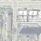
2 Blake Road Corridor Study Final Report Executive Summary Blake Road Corridor Study Final Report Purpose of study The Blake Road corridor is expected to experience significant change over the next 20 years. A major catalyst for this change will be the opening of the Green Line Extension (Southwest LRT) and construction of a station at Blake Road. The LRT line is expected to open in In recognition of this change, the City of Hopkins and its partners initiated the Blake Road Corridor Study to address opportunities to: Provide better transportation opportunities for pedestrians, bicyclists, and bus transit users Provide better connections and access to the planned light rail station at Blake Road for all modes Provide better connections and access to adjacent neighborhoods, commercial nodes, schools, and recreational facilities Provide transportation infrastructure to support redevelopment in and near the corridor that will enhance economic growth, community connectivity, and residential diversity. As part of the study, the project team analyzed existing and future conditions, developed alternatives to improve conditions in the corridor, evaluated alternatives, and recommended a design concept for transportation improvements in the corridor. The public and affected agencies were involved throughout the study process. Study area The project study area includes Blake Road between Interlachen Boulevard to Trunk Highway (TH) 7 and Aquila Avenue between TH 7 and 36th Street. Figure i1 shows the location of the study area. The study corridor spans three cities: Edina (Interlachen Boulevard to Spruce Road), Hopkins (Spruce Road to TH 7), and St. Louis Park (TH 7 to 36th Street). While the name of the street changes at TH 7, the study area is referred to as the Blake Road Corridor for the purpose of this study. Study participants The study was led by the City of Hopkins and guided by a Technical Advisory Committee (TAC) with representatives from the following agencies: City of Hopkins City of Edina City of St. Louis Park Hennepin County SWLRT Project Office Minnehaha Creek Watershed District (MCWD) Three Rivers Park District Minnesota Department of Transportation (MnDOT) i
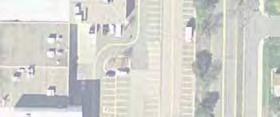
3 North Cedar Lakes Regional Aquila 36th St W Ave S 37th St W S uis Park Hopkins KNOLLWOOD MALL Cambridge St es Texas Av Oxford St Hiawatha Ave Lake St NE Lake St NE Lake St NE Lake St NE Cedar Lake Regional Trail 2nd St Ne SWLRT Freight Excelsior Blvd Proposed LRT Park and Ride and future development GbWX Boyce Rd ST JOHN S CATHOLIC SCHOOL ST LOUIS PARK Saint Louis Park Hopkins HOPKINS BLAKE LOWER SCHOOL - HOPKINS CAMPUS S Rd lak e Goodrich St Spruce Rd HOPKINS EDINA Hopkins Edina Belmore Ln Maloney Avenue Blake Rd S Waterman Ave Interlachen Blvd Feet ± LEGEND Project Study Area Bituminous Path Existing Sidewalks Existing Regional Trail Proposed Trail On Street Bike Lane Municipal Boundary Railroad SWLRT Blake Road Corridor Study Figure i1: Study Area
4 Blake Road Corridor Study Final Report Study goals Early in the study process, the TAC developed study goals to guide the development and evaluation of alternatives for the Blake Road Corridor. The goals of the study included the following: Facilitate access to the future Southwest LRT Blake Road station Create a roadway that is comfortable, safe, and functional for all transportation modes: pedestrian, bicycle, motor vehicle, freight, and transit Support redevelopment and make the roadway a place that is comfortable and active Protect and enhance natural resources near the roadway including Minnehaha Creek Improve connections between the roadway and nearby neighborhoods, parks, and trails Improve connections to Minnehaha Creek and nearby trails Public involvement The public involvement process included open houses, neighborhood meetings, a Technical Advisory Committee (TAC), and meetings with elected officials. Three open house meetings were held as part of the planning process. Notice of each open house was posted on city websites and mailed to residents and property owners along the corridor. Input from each meeting was documented and provided to the TAC. The project team reached out to neighborhood residents and property owners through additional meetings and attendance at events. Project staff attended an event in Cottageville Park, met with Westside Village Apartments management and residents, and met with representatives from the Blake Road Corridor Collaborative and the Blake School. Throughout the project, the City of Hopkins maintained a project webpage for the Blake Road Corridor Study. The webpage listed meeting announcements and materials from each open house. Edina and St. Louis Park also posted meeting announcements on their city websites. A TAC was convened at the beginning of the project to ensure that all interested agency stakeholders were involved in the study process. The TAC was composed of staff from the agency partners listed under Study Participants. The TAC met monthly to guide the study process, review and discuss technical analyses, provide direction on alternatives development and evaluation, and work together to determine the preferred alternative. The project team presented study progress to elected officials at several stages during the project. Staff provided updates at Edina, St. Louis Park, and Hopkins City Council Work Sessions in August and September Staff also presented the preferred alternative at an April 14, 2015 Hopkins City Council Work Session. Evaluation Process The project team developed several alternatives to address the goals of the project. These alternatives addressed roadway width and number of lanes, pedestrian and bicycle facilities, pedestrian crossings, and intersection design. The alternatives were evaluated based on the following criteria: iii
5 Blake Road Corridor Study Final Report Traffic operations: Ability to provide sufficient capacity for the existing and forecast volumes on Blake Road and cross streets. Safety and conflict points: Ability to reduce crashes on Blake Road and minimize conflict points between corridor users. Pedestrian and bicycle crossings - delay, safety, and directness: Measure of the distance of pedestrian and bicycle crossings, safety of crossings, and ability to directly link pedestrians and bicyclists to destinations in the corridor. Bicycle facility safety and comfort for likely users: Ability for the bicycle facility to be comfortable and safe for a wide range of bicyclists. Pedestrian safety and comfort: Measure of the amount of separation the facility provides between pedestrians, vehicles, and bicyclists. Business/Residential Access: Measure of how many vehicle movements are preserved to and from businesses and residences on Blake Road. Right of way impacts Roadway cross-section width: Measure of how much right of way impacts are anticipated. Economic development: Related to right of way impacts, access, traffic operations, and bicycle and pedestrian enhancements. Construction cost: Estimated construction cost based on width of roadway. Maintenance costs and ease of maintenance: Measure of how easily the bicycle and pedestrian facilities can be maintained. Environmental: Ability to minimize and enhance environmental impacts adjacent to the roadway. Recommendations The evaluation of alternatives led to the following recommendations for the corridor. These recommendations are broken out by segment. Interlachen to Excelsior Boulevard Figure i2 shows the preferred alternative for Interlachen to Excelsior Boulevard. The recommended cross-section in this segment has two lanes with on-road bike lanes and sidewalk on the west side. The primary improvement in this section is the addition of a sidewalk on the west side of Blake Road. The sidewalk would provide a facility for pedestrians from the residential areas south of Excelsior Boulevard, and provide connection to Excelsior Boulevard, the future Blake Road LRT station and other areas on Blake Road north of Excelsior Boulevard. It is recommended to maintain the existing bike lanes on Blake Road south of Excelsior Boulevard. Existing and projected traffic volumes are low enough that the bike lane will continue to be a comfortable facility for many bicyclists. Excelsior Boulevard to TH 7 Figure i3 shows the preferred alternative for Blake Road between Excelsior Boulevard and TH 7. The recommended cross-section in this segment is a four lane divided roadway with multi-use iv


6 Spruce Rd Excelsior Blvd Blake Road Belmore Ln Boyce Rd Blake School Entr Maloney Ave Goodrich St Waterman Ave Int erl Blake Road Corridor Study ach en Blv d Figure i2: Preferred Alternative between Interlachen and Excelsior Boulevards


7 Cambridge Street Oxford St Hiawatha Ave 2nd e St Lak W E St N RT L ake rl da Ce Excelsior Blvd Blake Road Corridor Study Figure i3: Preferred Alternative between Excelsior Boulevard and Highway 7
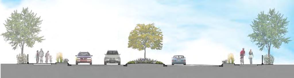
8 Blake Road Corridor Study Final Report trail on both sides of Blake Road. The 10 foot multi-use path on both sides of Blake Road will be a combined facility for bikes and pedestrians. Landscape and hardscape treatments were considered in this section during the evaluation phase to make sure that adequate space was provided to accommodate the urban design treatments that will create a friendly environment for pedestrians and bicyclists. Design and treatments along the boulevard and the multi-use trail will be developed further during the final design phase of this project. It is also recommended that the City of Hopkins consider zoning requirements for a green buffer strip between the multi-use trail and the adjacent properties to enhance the bicycle and pedestrian corridor and separate it from adjacent parking lots and buildings. It is also recommended that the overhead power lines in the corridor be put underground to further enhance the pedestrian and bicycle corridor. Detailed consideration was given to pedestrian crossings and intersections in the corridor. Intersection and crossing recommendations are summarized below: Excelsior Boulevard intersection: Recommendation to provide two southbound left turn lanes to provide adequate storage between the median opening at the West Side Village access and Excelsior Boulevard. Combined through and right-turn lanes on southbound Blake Road and northbound Blake Road are recommended in order to minimize crossing distance on Blake Road at the intersection. Median Opening at West Side Village Access: Full access recommended at this location to support existing development and future redevelopment. Pedestrian Crossing between Excelsior Boulevard and Railroad Tracks: A marked pedestrian crossing with Rectangular Rapid Flashing Beacon (RRFB) is recommended north of the West Side Village Access where there is a full width median. Cedar Lake Trail Crossing: Three Rivers Park District is proposing a grade separation at the Cedar Lake Trail crossing of Blake Road. It is recommended that no marked at grade crossing be provided where the Cedar Lake trail intersects with the Blake Road multi-use trail. 2 nd Street Intersection: A signalized intersection is recommended. The 2 nd Street signal will be interconnected with the railroad signal to avoid trapping vehicles on the LRT/railroad tracks. Lake Street Intersection: Side-street stop control is recommended. A marked pedestrian crossing with RRFB is recommended on the north side of the intersection. Minnehaha Creek Bridge: It is recommended that the Minnehaha Creek Bridge be retained. Oxford Street: It is recommended that the median extend through the intersection of Oxford Street and Blake Road. Oxford Street would have right in and right out access on Blake Road. Businesses on the west side of Blake Road would also have right in and right out access. Cambridge Street: No change in the lane configuration or traffic control is proposed at this intersection. The intersection of Cambridge Street and Blake Road will be signalized. vii
9 Blake Road Corridor Study Final Report TH 7: The intersection of Blake Road/Aquila Avenue and TH 7 is recommended to be modified to add a second left turn lane for northbound left turns on Blake Road and southbound left turns on Aquila Avenue. In addition the southbound free right on Aquila Avenue will be modified so that right-turns are made closer to TH 7. Modification of the southbound free right will be completed as part of a separate MnDOT project. A right-turn lane will be added for southbound right turns. It is recommended that the radius on all corners of the intersection be reduced to reduce right turn speeds and minimize pedestrian crossing distances. TH 7 to 36th Street Figure i4 shows the preferred alternative for Aquila Avenue between TH 7 and 36th Street. The recommended cross-section in this segment is a four-lane divided roadway with multi-use trail on both sides of Aquila Avenue. The roadway section in this segment will have a minimum 4 median at left turn lanes, 10.8 foot through lanes, a 4 foot median, a 7 foot boulevard and a 8 foot trail. This section will require acquisition of some right of way. No specific recommendations have been made regarding landscape or hardscape in this section The 36th Street intersection is recommended to be signalized and will have the same lane configuration as the current intersection. The 37th Street intersection is currently signalized. A roundabout was considered as an alternative at this intersection. The City of St. Louis Park will continue to evaluate both alternatives for this intersection. Cost Estimate The estimated construction costs for the improvements are approximately $11.7 million in current dollars (2015). A 20% contingency is included in the construction costs. The estimate includes approximately $2.3 million for engineering and administration costs. The estimate does not currently include any costs for city utilities, undergrounding the overhead power lines or for right-of-way. The estimated construction costs are based on conceptual design and will change as more detail design is completed. Next Steps The recommendations in this study represent a concept design for the corridor that addresses the goals of the various stakeholders. There is significant additional design that is required before final costs and right of way can be determined. Additional study is needed of the utilities in the corridor to determine what should be replaced and the location for the utilities. As indicated earlier more detail also needs to be developed for the urban design elements of the corridor. The next step in the engineering process is to complete final design for the corridor which will help establish final construction limits and right of way needs. Environmental Review This project is subject to state environmental regulations and potentially subject to federal environmental regulations depending on the funding sources. Either a Project Memo or Environmental Assessment would be required if the project receives federal funding. It is recommended that a state EAW be completed for the project. viii


10 36th St W 37th St W 4 Blake Road Corridor Study Figure i4: Preferred Alternative between Highway 7 and 36th Street
11 Blake Road Corridor Study Final Report Funding Sources A variety of funding sources will be utilized to construct this project. Local funding sources could include: City of Hopkins: Local utilities and undergrounding of overhead utilities on Blake Road between Excelsior Boulevard and TH 7 City of St. Louis Park: Aquila Avenue Improvements City of Edina: Sidewalk improvements in Edina Hennepin County: Blake Road between Excelsior Boulevard and TH 7 MnDOT: TH 7 intersection Potentially Cooperative Agreement Funds In addition, federal funding sources will be pursued and could include: TIGER Grant: Federal funding for multi-modal transportation projects that generate economic development and improve access to reliable, safe, and affordable transportation. The minimum federal funding per project is $10 million. Transportation Alternatives Program: Federal funds administered through the Metropolitan Council that could be used for multi-use trail and aesthetic enhancements. Coordination with other projects The design of this project needs to be coordinated with several other projects that will be designed and potentially constructed in the same time frame. This includes: Southwest LRT and Blake Road Station Area Cedar Lake Regional Trail grade separation Cold Storage Site Development Plans Highway 7 intersection improvements City of Hopkins local street reconstruction x
12 Blake Road Corridor Study Final Report Table of Contents Executive Summary... i 1. Introduction... 1 Purpose of study... 1 Study Area... 1 Study participants... 3 Study goals Public and Agency Involvement... 3 Open House Meetings... 3 Neighborhood/property owner meetings... 4 Project webpage... 5 Technical Advisory Committee (TAC) meetings... 5 Meetings with elected officials Existing conditions... 5 Land use... 5 Roadway characteristics... 7 Safety... 8 Traffic operations Bicycle and pedestrian facilities Transit service Future Conditions Transit service Land use and development Traffic Forecasts xi
13 Blake Road Corridor Study Final Report Traffic operations Pedestrian and Bicycle Transportation Evaluation Criteria Alternatives Development and Evaluation Alternatives Considered between Excelsior Boulevard and TH Evaluation of Alternatives Interlachen Boulevard to Excelsior Boulevard TH 7 to 36th Street Recommendations Interlachen to Excelsior Boulevard Excelsior Boulevard to TH TH 7 to 36th Street Cost Estimate Next Steps Environmental Review Funding Sources Coordination with other projects Appendix Blake Road Corridor Study Alternatives Evaluation Memo xii
14 Blake Road Corridor Study Final Report 1. Introduction Purpose of study The Blake Road corridor is expected to experience significant change over the next 20 years. A major catalyst for this change will be the opening of the Green Line Extension (Southwest LRT) and construction of a station at Blake Road. The LRT line is expected to open in In recognition of this change, the City of Hopkins and its partners initiated the Blake Road Corridor Study to address opportunities to: Provide better transportation opportunities for pedestrians, bicyclists, and bus transit users Provide better connections and access to the planned light rail station at Blake Road for all modes Provide better connections and access to adjacent neighborhoods, commercial nodes, schools, and recreational facilities Provide transportation infrastructure to support redevelopment in and near the corridor that will enhance economic growth, community connectivity, and residential diversity. As part of the study, the project team analyzed existing and future conditions, developed alternatives to improve conditions in the corridor, evaluated alternatives, and recommended a design concept for transportation improvements in the corridor. The public and affected agencies were involved throughout the study process. This report documents the study process and analysis. Study Area The project study area includes Blake Road between Interlachen Boulevard to Trunk Highway (TH) 7 and Aquila Avenue between TH 7 and 36th Street. Figure 1 shows the location of the study area. The study corridor spans three cities: Edina (Interlachen Boulevard to Spruce Road), Hopkins (Spruce Road to TH 7), and St. Louis Park (TH 7 to 36th Street). While the name of the street changes at TH 7, the study area is referred to as the Blake Road Corridor for the purpose of this study. Blake Road is one of a limited number of continuous north-south roadways between US 169 and TH 100. The corridor is approximately 1.7 miles long. The context of the corridor varies, from single family residential at the south end to commercial at the north end. Blake Road is designated as a Major Collector for the entire length of the study area. Blake Road is also Hennepin County State Aid Highway (CSAH) 20 between Excelsior Boulevard and TH 7. 1
15 North Cedar Lakes Regional Aquila 36th St W Ave S 37th St W S uis Park Hopkins KNOLLWOOD MALL Cambridge St es Texas Av Oxford St Hiawatha Ave Lake St NE Lake St NE Lake St NE Lake St NE Cedar Lake Regional Trail 2nd St Ne SWLRT Freight Excelsior Blvd Proposed LRT Park and Ride and future development GbWX Boyce Rd ST JOHN S CATHOLIC SCHOOL ST LOUIS PARK Saint Louis Park Hopkins HOPKINS BLAKE LOWER SCHOOL - HOPKINS CAMPUS S Rd e Goodrich St Spruce Rd HOPKINS EDINA Hopkins Edina Belmore Ln Maloney Avenue Blake Rd S Waterman Ave Interlachen Blvd Feet ± LEGEND Project Study Area Bituminous Path Existing Sidewalks Existing Regional Trail Proposed Trail On Street Bike Lane Municipal Boundary Railroad SWLRT Blake Road Corridor Study Figure 1: Study Area
16 Blake Road Corridor Study Final Report Study participants The study was led by the City of Hopkins and guided by a Technical Advisory Committee (TAC) with representatives from the following agencies: City of Hopkins City of Edina City of St. Louis Park Hennepin County SWLRT Project Office Minnehaha Creek Watershed District (MCWD) Three Rivers Park District Minnesota Department of Transportation (MnDOT) The TAC met a total of 12 times throughout the study process. Study goals Early in the study process, the TAC developed study goals to guide the development and evaluation of alternatives for the Blake Road Corridor. The goals of the study included the following: Facilitate access to the future Southwest LRT Blake Road station Create a roadway that is comfortable, safe, and functional for all transportation modes: pedestrian, bicycle, motor vehicle, freight, and transit Support redevelopment and make the roadway a place that is comfortable and active Protect and enhance natural resources near the roadway including Minnehaha Creek Improve connections between the roadway and nearby neighborhoods, parks, and trails Improve connections to Minnehaha Creek and nearby trails 2. Public and Agency Involvement The Blake Road Corridor Study was informed by public and agency input. The following sections summarize public and agency involvement activities that occurred during the course of the study. Open House Meetings Three open house meetings were held as part of the planning process. Notice of each open house was posted on city websites and mailed to residents and property owners along the corridor. Input from each meeting was documented and provided to the TAC. Open House 1: June 25, 2014 The purpose of the first open house was to present the study team s understanding of existing issues and conditions and gather public feedback on the needs and opportunities in the corridor. 3
17 Blake Road Corridor Study Final Report Comments received at the first open house fell into the following themes. These comments were incorporated into the alternatives developed through the corridor study: Traffic operations and safety concerns Pedestrian crossings of Blake Road and the need for sidewalks on intersecting streets Desire for bicycle facilities on Blake Road Safety concerns about the Cedar lake Regional Trail crossing of Blake Road Access to future Southwest LRT station for pedestrians, bicyclists, and bus users Concern about maintaining access to commercial and rental properties along the corridor Open House 2: October 9, 2014 The purpose of this open house was to present alternatives developed to address issues in the Blake Road corridor. Feedback on alternatives is summarized below: TH 7 intersection: Most meeting attendees preferred a pedestrian/bicycle bridge on the east side of TH 7. Intersections at 2nd and Lake Street: There was not a clear opinion among meeting attendees about their preference for roundabouts or signalized/thru-stop intersections. Pedestrian crossing between CSAH 3 and RR tracks: More meeting attendees preferred a crossing close to the future LRT tracks; however, several attendees noted that people will still want to cross near Westside Village Apartments. Blake Road south of Excelsior Boulevard: Several attendees would like to see left turn lanes at Boyce Street and the Blake School entrance. Some were concerned about whether the proposed sidewalk would impact existing parking along the Blake School fields. Open House 3: April 20, 2015 At the third and final project open house, the project team shared information on the evaluation of alternatives and presented a layout of the preferred alternative. The following feedback was collected: Blake Road South of Excelsior Boulevard: Several residents were concerned about the impact of the proposed sidewalks on adjacent properties and trees. Overall project: A number of residents supported the proposed improvements. A few residents would prefer fewer lanes on Blake Road to promote a more bicycle- and pedestrian-friendly feel. Cedar Lake Regional Trail crossing: Several residents supported grade separation of the regional trail. Neighborhood/property owner meetings The project team reached out to neighborhood residents and property owners through additional meetings and attendance at events. Project staff attended an October 2014 event in Cottageville Park to provide information and gather input on the project. Staff also met with 4
18 Blake Road Corridor Study Final Report Westside Village Apartments management and residents during October Additionally, city staff met with representatives from the Blake Road Corridor Collaborative and the Blake School. Project webpage Throughout the project, the City of Hopkins maintained a project webpage for the Blake Road Corridor Study. The webpage listed meeting announcements and materials from each open house. Edina and St. Louis Park also posted meeting announcements on their city websites. Technical Advisory Committee (TAC) meetings A TAC was convened at the beginning of the project to ensure that all interested agency stakeholders were involved in the study process. The TAC was composed of staff from the following agencies: City of Hopkins City of Edina City of St. Louis Park Hennepin County Minnehaha Creek Watershed District (MCWD) Three Rivers Park District Minnesota Department of Transportation (MnDOT) The TAC met monthly to guide the study process, review and discuss technical analyses, provide direction on alternatives development and evaluation, and work together to determine the preferred alternative. Minutes of TAC meetings are available upon request. Meetings with elected officials The project team presented study progress to elected officials at several stages during the project. Staff provided updates at Edina, St. Louis Park, and Hopkins City Council Work Sessions in August and September The purpose of these meetings was to share draft concepts for Blake Road and gather direction on refinement and evaluation of alternatives. Staff also presented the preferred alternative at an April 14, 2015 Hopkins City Council Work Session. 3. Existing conditions The purpose of this section of the report is to provide context for the alternatives generated through the corridor study. This information was gathered from comprehensive plans, MnDOT traffic count data, additional traffic counts, and input from the public and study stakeholders. The following is an overview of the existing corridor characteristics. Land use Land use varies throughout the corridor. The following sections describe the land use adjacent to Blake Road and Aquila Avenue, as shown in Figure 2. The Blake Road corridor is urbanized and fully developed. 5
19 Highway 7 Aquila Ave S 37th St W KNOLLWOOD MALL Knollwoo Blake Rd N d 36th St W Mall Acces Rd Cambridge St Highway 7 Oxford St Hiawatha Ave Lake St Ne 2nd St Ne Blake Rd N GbWX Excelsior Blvd Boyce Rd Goodrich St Legend Spruce Rd Project Location Single Family Detached Manufactured Housing Park Single Family Attached Multifamily Retail and Other Commercial Office Mixed Use Residential Mixed Use Industrial Mixed Use Commercial and Other Industrial and Utility Institutional Park, Recreational or Preserve Golf Course Major Highway Railway Undeveloped Water M endelssohn Ln Blake Rd S Belmore Ln Maloney Ave Waterman Ave 0 1, Feet ± Blake Road Corridor Study Figure 2: Land Use in the Blake Road Corridor
20 Blake Road Corridor Study Final Report Interlachen to Excelsior Boulevard Land use in this section is single-family residential and institutional. Shepherd of the Hills Lutheran Church is located in the southern end of the corridor, at Maloney Avenue. The Blake School is located at the southwestern corner of Blake Road and Excelsior Boulevard. The school property extends along Blake Road to Spruce Road. Excelsior Boulevard to TH 7 This segment of Blake Road is adjacent to commercial, industrial, park, and multi-family residential land use. Retail commercial uses are concentrated on the west side of Blake Road between Excelsior Boulevard and 2nd Street NE and between TH 7 and Oxford Street. There are several large multifamily residential buildings on the northeast corner of Blake Road and Excelsior Boulevard (Westside Village Apartments) and on the west side of Blake Road between Oxford and 2nd Streets. The Cold Storage site is the sole industrial land use on the corridor, located on the east side of the road between the Cedar Lake LRT Regional Trail and Lake Street. Cottageville Park is located on the east side of Blake Road between Lake and Oxford Streets. Blake Road bridges Minnehaha Creek in this location. Minnehaha Creek runs through the southern portion of the park. The park features a playground, basketball court, community garden plots, and picnic tables. Minnehaha Creek passes underneath Blake Road just north of Lake Street. Water quality in this section has been degraded due to increased impervious surfaces in the watershed (resulting in increase in stormwater runoff and pollution loads) and loss of wetlands. TH 7 to 36th Street Retail commercial land uses are located adjacent to Aquila Avenue between TH 7 and 36th Street. Knollwood Mall is located on the east side of Aquila Avenue. Minnehaha Creek and associated wetlands are located on the west side of Aquila Avenue. Roadway characteristics Interlachen to Excelsior Boulevard Blake Road is a two-lane undivided roadway between Interlachen Boulevard and Boyce Street. This segment is primarily an urban roadway with curb and gutter, though there is no curb on the west side of Blake Road between Boyce Street and Spruce Road. In this location, there is a gravel strip adjacent to the edge of the roadway that is used for parking. There are no signals in this segment. All intersections are side-street stop controlled. Between Boyce Street and Excelsior Boulevard, a raised concrete median develops. In the northbound direction, Blake Road widens to two through lanes, a left turn lane, and right turn lane. South of Excelsior Boulevard, Blake Road narrows from two to one southbound lane. There is a traffic signal at Blake Road and Excelsior Boulevard. Excelsior Boulevard to TH 7 This segment varies between a four-lane divided and five-lane undivided roadway. A raised concrete median creates a four-lane divided roadway between Excelsior Boulevard and just north of the Cedar Lake LRT Trail/railroad tracks. There is also an existing concrete median 7
21 Blake Road Corridor Study Final Report between TH 7 and just south of Oxford Street. The remainder of the roadway is five-lane undivided. Traffic signals are in place at Excelsior Boulevard (CSAH 3), 2nd Street, Cambridge Street, and TH 7. All other intersections are side-street stop controlled. The Excelsior Boulevard intersection includes free-right turn lanes (southbound to westbound and westbound to northbound) and a southbound left turn lane. At Hill Street (350 feet north of Excelsior Boulevard), there are northbound and southbound left turn lanes and a southbound right turn lane. There are free right turn lanes (southbound to westbound and eastbound to southbound) at 2nd Street. At TH 7, there are northbound right and left turn lanes and a southbound free right turn lane from eastbound TH 7. There is an active freight rail crossing of Blake Road 500 feet south of 2nd Street. There are gate arms at this rail crossing. TH 7 to 36th Street This segment is a four-lane divided roadway with traffic signals at TH 7, 37th Street, and 36th Street. At TH 7, there is a southbound left turn lane and southbound free-right turn lane. There are left turn lanes and a northbound right turn lane at 37th Street. There are left turn lanes at the Knollwood Mall entrance 550 feet south of 36th Street. At 36th Street, there is a northbound left turn lane and eastbound to southbound free right turn lane. Safety Three years ( ) of MnDOT crash data were reviewed to understand safety problems in the corridor. The sections below highlight existing safety conditions on Blake Road. Because most of the intersections in the corridor are signalized, most crashes are intersection-related. Figure 3 summarizes the results of crash analysis at intersections on Blake Road. At Excelsior Boulevard and 2nd Street the number and severity of crashes is lower than similar intersections. Most crashes at Excelsior Boulevard (63 percent) were rear end crashes. At 2nd Street, most (58 percent) of crashes were right angle. The number and severity of crashes on the segment of Blake Road between Interlachen and Excelsior Boulevard was also lower than similar segments. The number and severity of crashes at Lake, Cambridge, 36th and 37th Streets were about the same as similar intersections. Most crashes at Lake and Cambridge Streets were rear end crashes. At both 36th and 37th Street, most crashes were left-turn crashes. At TH 7, the number of crashes exceeds the critical crash rate and the average severity rate. Most (77 percent) of crashes were rear end. Two crashes involved pedestrians. 8
22 618 8 TH 7: 61 crashes % 16% 7% 77% % 25% 18% 58% Rear End Right Angle Other Crashes Involving Pedestrians: 2 Cambridge St: 17 crashes Rear End Side Swipe Other Crashes Involving Bicyclists: 1 Phillips Pkwy?«A@ Aquila 36th St W Ave S 37th St W S uis Park Hopkins KNOLLWOOD MALL Cambridge St Oxford St es Texas Av 36th St: 12 crashes 42 25% 25% 42% 8% 25% 37th St: 12 crashes 42 33% 25% 33% 42% Rear End Side Swipe Left Turn Right Angle Side Swipe Left Turn Other Lake St: 6 crashes 49 49% 17% 17% 17% 49% 2nd St: 7 crashes % 14% 58% 14% 13 18% 33 33% 33% 33% 33% Rear End Left Turn Right Angle Other Crashes Involving Bicyclists: 1 Right Angle Left Turn Rear End Side Swipe Excelsior Boulevard: 16 crashes Rear End 18% 13% Side Swipe 6% Left Turn 63% Other Crashes Involving Pedestrians:1 Excelsior - Interlachen Blvd: 3 crashes Rear End Ran off Road Right Angle Crashes Involving Bicyclists: 1 Excelsior Blvd BLAKE LOWER SCHOOL - HOPKINS CAMPUS Hiawatha Ave Belmore Ln Maloney Avenue Lake St NE 2nd St Ne Spruce Rd S Rd e Blake Rd S Lake St NE Regional Trail Crossing - 3 rear-end crashes GbWX Boyce Rd Goodrich St HOPKINS EDINA Waterman Ave Interlachen Blvd SWLRT Proposed LRT Park and Ride and future development Freight ST JOHN S CATHOLIC SCHOOL ST LOUIS PARK Saint Louis Park Hopkins HOPKINS LEGEND Cedar Lake Regional Trail Number of Crashes Number & severity of crashes significantly higher than similar intersections Number & severity of crashes about the same as similar intersections Number & severity of crashes lower than similar intersections or segments Blake Road Corridor Study Figure 3: Crash Analysis
23 Blake Road Corridor Study Final Report Traffic operations As part of the project, existing traffic operations were modeled based on traffic counts conducted between 2011 and Figure 4 shows existing traffic volumes that were used to analyze traffic operations in the corridor. The section below describes the results of motor vehicle level of service analysis on the corridor. Level of service A and B indicate that there is little congestion during peak periods, while level of service C and D indicate some congestion during peak periods. Level of service E and F indicates significant congestion during peak periods. Figure 5 shows existing level of service at intersections on Blake Road. Level of service was analyzed at all signalized intersections as well as Lake Street (currently side-street stop controlled). Existing level of service at Blake Road intersections is generally within level of service A to B, with the exception of Lake Street (B-C) and TH 7 (C-E). It can be challenging for drivers to enter and cross Blake Road from Lake Street during peak hours. Traffic on Blake Road backs up during peak periods because the signal cycle gives preference to traffic on TH 7. Bicycle and pedestrian facilities Interlachen to Excelsior Boulevard Between Interlachen Boulevard and Boyce Street, there are striped bike lanes in both directions and no sidewalk. Between Boyce Street and Excelsior Boulevard, there is a concrete sidewalk at the back of the curb on the east side of the roadway. On the west side of the road, there is a concrete sidewalk that transition to a bituminous trail. There is one marked crosswalk across Blake Road at Spruce Road. Excelsior Boulevard to TH 7 There are continuous sidewalks along both sides of Blake Road between Excelsior Boulevard and TH 7. Sidewalks are at the back of the curb. There are no bicycle facilities on this segment of Blake Road. The Cedar Lake LRT Regional Trail crosses Blake Road 500 feet south of 2nd Street and is heavily used by pedestrians and bicyclists. This is an unmarked, mid-block crossing with trail crossing warning signs on Blake Road approaches to the crossing. There is demand for pedestrian crossings at two uncontrolled locations: Lake Street and Hill Street (350 feet north of Excelsior Boulevard). Pedestrians currently cross Blake Road in these locations. TH 7 to 36th Street This segment has continuous sidewalk along both sides. Generally the sidewalks are separated from the roadway by a boulevard; however, the sidewalk is at the back of the curb in some locations. 10
24 Texas Texas Ave Ave S S 1st St N North Cedar Lake Trail St Louis St 7,000 Hiawatha Park (! s k W 36th St 5,900 Aquila Ave S W 37th St 37,000 Hiawatha Hiawatha Ave Ave! ( 5,200 Saint Louis Park Hopkins Lake St NE KNOLLWOOD MALL 2nd St NE (! (! (!! ( Blake Rd 7 Cambridge St Oxford St W Lake St Excelsior Blvd Saint Louis Park Hopkins Cedar Lake Trail Cedar Lake Trail 18,400 7,600 14,500 15,200 11,800 SWLRT 37, Freight Freight Proposed LRT Park and Ride and future development 15,800 Walker Park Boyce St Golf Course Monroe Ave S Harley Hopkins Park Harley Hopkins Family Center Alden Park Alden Park 1st St S 2nd St S 7,300 Goodrich St Spruce Rd Hopkins Edina Interlachen Park Interlachen Park LEGEND 2010/2011 Annual Average Daily Traffic Volume (ADT) Belmore La ( Traffic Signal 1,800 Maloney Ave Blake Rd Gated Railroad Crossing Interlachen Golf Club Van Valkenburg Park Van Valkenburg Park 7,100 Blake Rd Mirror Lake Interlachen Blvd Blake Road Corridor Study Figure 4: Existing Traffi c Volumes
25 36th St AM Level of Service Existing Overall A North Bound A South Bound A East Bound A West Bound B PM Level of Service Existing Overall A North Bound A South Bound A East Bound A West Bound B Pkwy Aqu e S Tex as Av 37th St AM Level of Service Existing Overall A North Bound A South Bound A East Bound B West Bound C PM Level of Service Existing Overall B North Bound A South Bound C East Bound B West Bound E?@A? 37t S u Hopk Ox TH 7: AM Level of Service Existing Overall C North Bound D South Bound D East Bound C West Bound C PM Level of Service Existing Overall E North Bound E South Bound F East Bound D West Bound D SWLRT Freigh eight Cambridge St: ST LOUIS O S PARKK AM Level of Service Existing Overall B North Bound B South Bound B East Bound C West Bound C PM Level of Service Existing Overall B North Bound B South Bound C East Bound B West Bound E Ex vd Bo development ent Lake St: AM Level of Service Existing East Bound C West Bound C PM Level of Service Existing East Bound B West Bound E 2nd St: AM Level of Service Existing Overall B North Bound B South Bound A East Bound C West Bound C PM Level of Service Existing Overall B North Bound A South Bound B East Bound C West Bound E B Rd S HOPKINS Hopkins Edina LEGEND Intersections with existing overall service level of E-F (significant congestion in peak times) Excelsior Boulevard: AM Level of Service Existing PM Level of Service Existing Overall C Overall C North Bound D North Bound D South Bound C South Bound C East Bound C East Bound C West Bound C West Bound C Inter Intersections with existing overall service level of C-D (some congestion in peak times) Intersections with existing overall service level of A-B (little congestion in peak times) Feet ± Blake Road Corridor Study Figure 5: Existing Intersection Level of Service
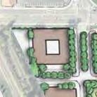
26 Blake Road Corridor Study Final Report Transit service Blake Road is served by two Metro Transit routes: 17 and 668. Route 17 is a local bus route serving Hopkins, St. Louis Park, and Minneapolis at approximately minute headways on weekdays and weekends. Route 17 stops at Hiawatha Avenue and Lake, Oxford, Cambridge, 37th, and 36th Streets. Route 668 is an express route linking Hopkins and St. Louis Park with downtown Minneapolis. This route stops at 2nd, Lake, Oxford, and Cambridge Streets and provides service every 30 minutes during the morning and evening weekday rush hours. 4. Future Conditions Transit service Transit service in the Blake Road corridor is expected to expand. The planned Southwest Light Rail Transit (LRT) line/green Line Extension is expected to begin service as soon as A station is planned at Blake Road on the west side of the road, just south of the existing freight rail line. The Southwest LRT line will link Eden Prairie, Minnetonka, Hopkins, St. Louis Park, and Minneapolis with service every 15 minutes. At the line s terminus at Target Field Station in Minneapolis, passengers will be able to connect to LRT service to St. Paul (Green Line) and Bloomington (Blue Line). A 477-space Park and Ride is planned adjacent to the future Blake Road station. Blake Road is expected to carry additional pedestrian, bicycle, transit, and vehicle traffic accessing the LRT station. Changes to existing bus transit routes are expected to occur in coordination with the opening of Southwest LRT. It is likely that an increased number of buses will travel on Blake Road in the future to provide feeder service to the LRT station. Details of bus route changes and additions will be determined one to two years prior to the start of LRT service. Land use and development Significant land use and development changes are not expected on the north or south ends of the corridor. Land use and development changes are expected to be concentrated between Excelsior Boulevard and TH 7. The City of Hopkins expects commercial and residential redevelopment to occur on Blake Road, in part due to the future Blake Road LRT station. Below is a summary of expected land use and development changes in the corridor. Blake Road Southwest LRT Station and Associated Development As mentioned above, a 477-space Park and Ride is planned for the Blake Road LRT station. Current plans anticipate joint commercial development with the Park and Ride. Additional commercial and residential redevelopment is expected in the area surrounding the LRT station (northwest quadrant of the Blake Road-Excelsior Boulevard intersection). The LRT station, Park and Ride, and any associated development will occur as a result of redevelopment of existing retail commercial land uses. 13
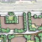
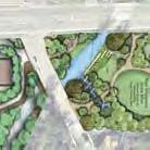
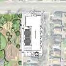
27 Blake Road Corridor Study Final Report Cold Storage Site The Minnehaha Creek Watershed District recently purchased the Cold Storage site. This site is on the west side of the road, north of the Cedar Lake LRT Regional Trail and south of Lake Street. The MCWD plans to construct stormwater improvements, greenway connections, and other water quality and habitat improvements on portions of the site, primarily adjacent to Minnehaha Creek. The remainder of the site will be made available for residential and/or commercial redevelopment. While some redevelopment concepts have been prepared, there are no firm site plans at this time. Cottageville Park The City of Hopkins plans an expansion and renovation of Cottageville Park within the next several years. Improvements are planned both north and south of Minnehaha Creek. Current plans include water quality and habitat improvements, a canoe launch, play area, soccer field, pavilion, and lawn for events and informal use. Oxford Green Apartments A 51 unit apartment building is planned for the west side of Blake Road, between Cottageville Park and Oxford Street. The apartment building will be constructed in place of six duplexes planned to be removed. Metropolitan Council Lift Station Metropolitan Council is planning to relocate the existing lift station located on the northwest corner of Blake Road and Lake Street. The lift station will be relocated outside of the Blake Road Corridor to a location 600 feet west of Blake Road on Hiawatha Avenue. Other Development Several recent studies have identified potential land use changes in Blake Road Corridor. The Blake Road Small Area Plan (2009) identified opportunities for retail and housing development north of the future LRT station (along 2nd Street) and housing redevelopment along Oxford Street and at the Cold Storage Site. The Southwest Corridor Investment Framework (2014 formerly known as Transitional Station Area Action Plans) evaluated potential development sites near the future LRT station. The study determined there is potential for mixed-use residential redevelopment at the Cold Storage site, between the future LRT station and 2nd Street, and between the future station and Excelsior Boulevard. The study also found potential opportunities for multi-family residential north of Excelsior Boulevard (between Taylor and Pierce Avenues) and retail and other commercial development north of Excelsior Boulevard, to the east of Westside Village apartments. Additionally, the City of Hopkins is currently studying future redevelopment in the Blake Road LRT station area. The city is considering opportunities to intensify land uses in the corridor. 14
28 Blake Road Corridor Study Final Report Traffic Forecasts Figure 6 shows 2035 forecast traffic volumes for the Blake Road corridor. Forecast traffic volumes are based upon assumptions related to future redevelopment in the corridor, including the Blake Road LRT station, associated development in the northwest quadrant of the Blake Road and Excelsior Boulevard intersection, and the Cold Storage site. Table 1 shows the anticipated land use changes expected in the corridor and the change in trip generation associated with this land use. Figure 7 shows the expected distribution of future trips in the corridor. Land use assumptions were based on the redevelopment scenario identified in the Southwest Corridor Investment Framework. Forecast volumes assume no growth in background traffic. Future traffic operations were analyzed based on 2035 forecast volumes. Projected intersection level of service is described below and assumes no changes to Blake Road. Traffic operations Figure 8 shows future level of service at intersections on Blake Road. Intersection level of service is generally not expected to worsen. The exception is at TH 7, with an expected level of service of D-F. Level of service at Lake Street is also expected to worsen to C-F as traffic volumes on Blake Road make it more difficult to enter and exit Lake Street. Pedestrian and Bicycle Transportation It is expected that a greater number of pedestrians and bicyclists will use the Blake Road corridor as the Southwest LRT line begins service and redevelopment occurs in the corridor. It is anticipated that the Blake Road corridor will attract a wide range of bicyclist types, from adults accessing the LRT station or associated commercial development, families accessing corridor destinations and/or the Cedar Lake LRT Regional Trail, and bicyclists making longer transportation or recreation trips on the regional trail. Pedestrian and bicycle crossings of Blake Road will become more challenging as traffic volumes increase on Blake Road. 15
29 Texas Texas Ave Ave S S Walker Park 1st St N North Cedar Lake Trail St Louis St 7,900 Hiawatha Park (! 8,300 s k W 36th St Aquila Ave S W 37th St 39,000 Hiawatha Hiawatha Ave Ave! ( Saint Louis Park Hopkins 6,900 16,760 Lake St NE KNOLLWOOD MALL 2nd St NE (! (! (!! ( Blake Rd 7 Cambridge St Oxford St W Lake St Excelsior Blvd SWLRT 66 3 Freight Freight Proposed LRT Park and Ride and future development Saint Louis Park Hopkins Cedar Lake Trail Cedar Lake Trail 21,800 19,000 14,900 38,900 21,200 Boyce St Golf Course Monroe Ave S Harley Hopkins Park Harley Hopkins Family Center Alden Park Alden Park 1st St S 2nd St S 8,900 Goodrich St Spruce Rd Hopkins Edina Interlachen Park Interlachen Park LEGEND 2035 Forecasted Average Daily Traffic Volume (ADT) based on anticipated land use & development Belmore La ( Traffic Signal Maloney Ave Blake Rd Gated Railroad Crossing Interlachen Golf Club Van Valkenburg Park Van Valkenburg Park Blake Rd Mirror Lake Interlachen Blvd Blake Road Corridor Study Figure 6: Future Traffi c Volumes
30 TABLE 1: BLAKE ROAD CORRIDOR REDEVELOPMENT TRIP GENERATION Total SF AM Trips PM Trips Site Future Use (DU) ITE Code/Description In Out Total In Out Total Daily Trips 1 Mixed use Residential , Apartments Mixed use Retail 4, , Shopping Center Mixed use Residential , Apartments ,752 Mixed use Retail 20, , Shopping Center ,291 3 High density Residential , Apartments ,168 4 Mixed use Residential , Apartments ,605 Mixed use Retail 54, , Shopping Center ,454 Park and Ride* , Park and Ride Lot w/ Bus Service^ 2, ,309 5 Mixed use Non retail 430, , Office Park ,079 * Unit number is total parking spaces ,160 13,621 ^ ITE 093, LRT Station with Parking is not a reliable dataset 34% reduction for mixed use development (ITE Trip Generation, 9th Edition) 5% reduction for LRT users (SWLRT Mode Split by TAZ) Reductions do not include P&R
31 20% 37th St W 10% 15% S uis Park Hopkins Cambridge St Texas Oxford St 5% 5% 3 Hiawatha Ave Lake St NE 1 2nd St Ne 4 ake Rd N Blake Rd N l B Lake St NE 2 10% 5 5% SWLRT Saint Louis Hopkin 20% GbWX Excelsior Blvd 10% Boyce Rd Blake Road Corridor Study Figure 7: 2035 Trip Distribution
32 36th St AM Level of Service Future Overall A North Bound A South Bound A East Bound A West Bound B PM Level of Service Future Overall A North Bound A South Bound A East Bound A West Bound B Pkwy Aqu e S Tex as Av 37th St AM Level of Service Future Overall B North Bound A South Bound A East Bound B West Bound D PM Level of Service Future Overall B North Bound A South Bound C East Bound B West Bound E?@A? 37t S u Hopk Ox TH 7: AM Level of Service Future Overall D North Bound E South Bound F East Bound D West Bound D PM Level of Service Future Overall F North Bound F South Bound F East Bound F West Bound E SWLRT Freigh eight Cambridge St: ST LOUIS O S PARKK AM Level of Service Future Overall B North Bound A South Bound B East Bound C West Bound C PM Level of Service Future Overall B North Bound B South Bound C East Bound D West Bound B Ex vd Bo development ent Lake St: AM Level of Service Future East Bound C West Bound C PM Level of Service Future East Bound F West Bound F 2nd St: AM Level of Service Future Overall B North Bound B South Bound A East Bound C West Bound C PM Level of Service Future Overall C North Bound B South Bound C East Bound C West Bound B B Rd S HOPKINS Hopkins Edina LEGEND Intersections with existing overall service level of E-F (significant congestion in peak times) Excelsior Boulevard: AM Level of Service Future PM Level of Service Future Overall C Overall C North Bound D North Bound D South Bound C South Bound C East Bound C East Bound C West Bound C West Bound C Inter Intersections with existing overall service level of C-D (some congestion in peak times) Feet ± Intersections with existing overall service level of A-B (little congestion in peak times) Blake Road Corridor Study Figure 8: Future Intersection Level of Service
33 Blake Road Corridor Study Final Report 5. Evaluation Criteria The project team established evaluation criteria to be used in comparing alternatives for Blake Road. The evaluation criteria were based upon the goals established for the study and the issues identified by the project team and the public. The following evaluation criteria were used during the alternatives evaluation process: Traffic operations: Ability to provide sufficient capacity for the existing and forecast volumes on Blake Road and cross streets. Safety and conflict points: Ability to reduce crashes on Blake Road and minimize conflict points between corridor users. Pedestrian and bicycle crossings - delay, safety, and directness: Measure of the distance of pedestrian and bicycle crossings, safety of crossings, and ability to directly link pedestrians and bicyclists to destinations in the corridor. Bicycle facility safety and comfort for likely users: Ability for the bicycle facility to be comfortable and safe for a wide range of bicyclists. Pedestrian safety and comfort: Measure of the amount of separation the facility provides between pedestrians, vehicles, and bicyclists. Business/Residential Access: Measure of how many vehicle movements are preserved to and from businesses and residences on Blake Road. Right of way impacts Roadway cross-section width: Measure of how much right of way impacts are anticipated. Economic development: Related to right of way impacts, access, traffic operations, and bicycle and pedestrian enhancements. Construction cost: Estimated construction cost based on width of roadway. Maintenance costs and ease of maintenance: Measure of how easily the bicycle and pedestrian facilities can be maintained. Environmental: Ability to minimize and enhance environmental impacts adjacent to the roadway. 20
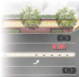
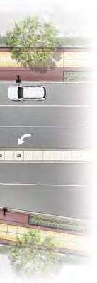
34 Blake Road Corridor Study Final Report 6. Alternatives Development and Evaluation Alternatives Considered between Excelsior Boulevard and TH 7 The following alternatives were identified as potential improvements to address the goals and objectives of the Blake Road Corridor Study. Alternatives are grouped into three categories: Roadway, Pedestrian and Bicycle Facilities, and Other Alternatives. Different evaluation criteria apply to each category. The following alternatives are compared below in the Evaluation Criteria section. Roadway Alternatives between Excelsior Boulevard and TH 7 (Figure 9) Three-lane Center left-turn lane and right-turn lanes (47 feet curb face to curb face) Four-lane undivided No separate turn lanes (48 feet curb to curb) Five-lane Center left-turn lane with no median and no right-turn lane (59 feet) Four-lane divided Median with left-turn lanes and no right-turn lane (65 feet) Pedestrian and Bicycle Facilities between Excelsior Boulevard and TH 7 (Figure 10) On-road bike lanes with sidewalk Cycle track with sidewalk Multipurpose trails Other Alternatives Excelsior Boulevard to Railroad Crossing (Figure 11) Median break at Westside Village apartment access for both vehicles and pedestrians Median break at Westside Village apartment access for pedestrians only Median break immediately south of railroad crossing No median break Cedar Lake Regional Trail Crossing (Figure 12) At grade crossing Grade separated Lake Street Pedestrian Crossing At-grade crossing Grade separated crossing Intersections at Lake and 2nd Streets (Figure 13) Signalized intersections Roundabouts Intersection at TH 7 (Figure 14) At-grade intersection Grade separated interchange 21
35 Blake Road Corridor Study Final Report Evaluation of Alternatives The following sections provide a brief summary of the alternatives and compare the key differences between alternatives as relate to the evaluation criteria. The full alternatives evaluation is available in the appendix. Roadway Alternatives Four different roadway sections were evaluated for the section of Blake Road from Excelsior Boulevard to TH 7. The alternatives evaluated are: Three-lane Center left-turn lane and right-turn lanes (47 feet curb to curb) Four-lane undivided No separate turn lanes (48 feet curb to curb) Five-lane Center left-turn lane with no median and no right-turn lane (59 feet curb to curb) Four-lane divided -- Median with left-turn lanes and no right-turn lane (65 feet curb to curb) These alternatives are shown in Figure 9. Below is a summary of the differences between the alternatives as identified through the alternatives evaluation process. Operations This criterion measures the ability to provide sufficient capacity for the existing and forecast volumes on Blake Road. A capacity analysis of the existing signalized intersections on Blake Road was completed for both the existing and forecast am and pm peak hour volumes to determine vehicle delay, level of service and queue lengths with the current lane geometry. The operations analysis was further refined by considering future travel times and delay for a subset of the roadway alternatives: four-lane divided roadway, three-lane roadway, unbalanced lanes (two lanes northbound, one lane southbound), and a three-lane roadway from 2nd to Cambridge Streets with a four-lane divided roadway in other locations. The purpose of this analysis was to determine whether a narrower roadway could provide enough capacity for anticipated future development in the corridor. The analysis of 2035 forecast hourly vehicle volumes shows that northbound traffic volumes would exceed the capacity of a three-lane roadway from approximately 3:30 to 6:30 PM each weekday (Chart 1). The three-lane alternative would also result in significantly greater average delay and total network travel time and delay during the peak hour (Charts 2 and 3). 22

36 Three-Lane Roadway Four-Lane Roadway Four-Lane Divided Roadway 67 Five-Lane Roadway Blake Road Corridor Study Figure 9: Roadway Alternatives between Excelsior Boulevard and Highway 7
37 Blake Road Corridor Study Final Report 1400 Chart 1: Blake Road North of 2nd Street Forecast 2035 Traffic Vehicles Per Hour Estimated Segment Capacity as 3-Lane (900 vph) Southbound Traffic Northbound Traffic :00 AM 1:00 AM 2:00 AM 3:00 AM 4:00 AM 5:00 AM 6:00 AM 7:00 AM 8:00 AM 9:00 AM 10:00 AM 11:00 AM 12:00 PM 1:00 PM 2:00 PM 3:00 PM 4:00 PM 5:00 PM 6:00 PM 7:00 PM 8:00 PM 9:00 PM 10:00 PM 11:00 PM Time of Day 24
38 Blake Road Corridor Study Final Report Seconds/vehicle Chart 2: Average Delay on Blake Road Excelsior to TH 7 (2035 PM Peak Hour) Northbound Blake Road Southbound Blake Road Alternatives Hours Chart 3: Total Network Travel Time and Delay Blake Road Corridor (2035 PM Peak Hour) Total Network Travel Time Total Network Delay Alternatives 25
39 Blake Road Corridor Study Final Report Further analysis compared the four-lane divided and three-lane unbalanced alternatives in terms of how much additional residential, office, and retail development could be accommodated under the different alternatives. As it was determined that the three-lane alternative does not provide adequate traffic operations, it was not considered in this analysis. The three-lane unbalanced alternative would be constrained by the capacity of the single southbound lane, which would allow for approximately an additional 100 vehicles per hour (vph) in the southbound lane. The four-lane divided alternative would be constrained by the capacity of the northbound lanes, which would provide an excess capacity of approximately 800 vph. This excess capacity would allow the four-lane alternative to accommodate significantly more future development than the three-lane unbalanced alternative. In conclusion, the four-lane divided and five-lane alternatives would provide adequate capacity for the future and better intersection operations than the other alternatives. The three-lane alternative fails to provide enough capacity to accommodate forecast 2035 traffic. The four-lane undivided alternative provides acceptable capacity at 2nd, but not at Excelsior, Cambridge, and TH 7. Safety This criterion measures whether the alternative will reduce crashes and conflicts on Blake Road. Rear end, right angle, and side swipe crashes are the three most common crash types on this segment of Blake Road. The roadway alternatives were evaluated based on their potential to reduce these types of crashes. The three-lane and four-lane alternatives perform the worst as relates to safety. The high level of congestion that would occur on a three-lane roadway would result in an increase in crashes. Four-lane roadways tend to have higher crash rates than other roadway designs, particularly related to rear end and side swipe crashes. The five-lane alternative is very similar to existing conditions on Blake Road and is not likely to reduce crash rates in the corridor. The four-lane divided alternative provides turn lanes and medians which help to reduce rear end and rightangle crashes. Pedestrian Crossings This criterion measures how well the alternative provides safe and direct pedestrian crossings. Shorter pedestrian crossing distances are generally safer for pedestrians, as pedestrians spend less time exposed to the risk of a crash with a vehicle. Medians can also improve safety by providing pedestrian refuge at intersections so that pedestrians can cross the roadway in two stages. The four-lane undivided and five-lane alternatives would result in challenging crossings for pedestrians, as without medians there are limited opportunities for pedestrian refuges. The three-lane alternative would provide the shortest crossing distance, but long queues and high levels of congestion would make crossing difficult. The four-lane divided alternative would result in wider crossing distances, but a median refuge area can be provided. 26
40 Blake Road Corridor Study Final Report Business and Residential Access This criterion measures how well the alternative provides for business and residential access along Blake Road. The existing roadway design provides full business and residential access at most mid-block locations. The four-lane divided alternative would result in loss of full access for several businesses and residences, as access would be limited to right-in and right-out. The three-lane alternative would provide full access to all adjacent properties but long queues and high levels of congestion will make access difficult. The four-lane undivided alternative would provide full access to all adjacent properties but lack of turn-lanes would make turning off or onto Blake Road difficult. The five-lane alternative ranks the highest in this category, as it would provide full access to all adjacent properties and provides a refuge area for vehicles. Right of Way Impacts This criterion measures the right of way impact of each roadway alternative. Alternatives that require less right of way will have lower right of way acquisition costs and fewer impacts to adjacent properties. The pedestrian and bicycle amenity zone will be approximately 20 feet on either side of the proposed roadway and therefore add about 40 feet of width to the overall cross-section. The existing roadway and sidewalk section between Excelsior Boulevard and TH 7 varies but is approximately 84 feet in width. The right-of-way varies from 84 feet just south of Cambridge to 112 feet south of TH 7. North of TH 7, the right-of-way is as narrow as 72 feet in locations. South of the Minnehaha Creek Bridge the right-of-way is between 90 and 94 feet. The three-lane and four-lane undivided alternatives require minimal right of way due to the narrower roadway width proposed. The five-lane alternative would require approximately a 5 to 10 foot strip of right of way which could be minimized in critical areas. The four-lane alternative would require the greatest amount of additional right of way. Approximately a 12 to 17 foot strip would be required; however, this could be minimized in critical areas. Construction Cost Typical construction cost for an urban arterial is approximately 200 dollars per lane foot in a corridor like Blake Road. This would include storm sewer, utility relocations and complete roadway reconstruction. Bridge replacement, retaining walls, median treatments, urban streetscape improvements and other unique features would be in addition to this amount. The distance between Blake Road and TH 7 is approximately 4000 feet. Based on these general estimates the roadway alternatives would have the following costs: Three-lane alternative -- $2,400,000 Four-lane undivided alternative -- $3,200,000 Five-lane alternative -- $4,000,000 Four-lane divided alternative --$4,400,000 Environmental Impacts Several measures were suggested for measuring the potential environmental benefits or impacts of the project relative to this criterion. These measures included: 27
41 Blake Road Corridor Study Final Report Connections to existing amenities Minnehaha Creek, Cottageville Park Stormwater Management Green Infrastructure Green Space Impervious Surfaces Build vs. No-build Impacts to water quality, air quality, noise, and health For many of these criteria the number of lanes will not determine how well the project addresses these criteria. For example, connections to existing amenities will not be affected by the number of lanes. On the other hand, as the number of lanes increases there is more impervious surface and less room available for green infrastructure. In this regard the environmental impacts will vary with the overall cross-section and right-of-way needs. In general, alternatives with greater right of way requirements are assumed to have greater environmental impacts. The three-lane alternative would have the least environmental impacts while the four-lane divided alternative would have the greatest environmental impacts. Economic Development This criterion measures the ability of the roadway to accommodate the cities economic development goals for the project. Measures related to place making, level of public amenities, and alignment with city s vision for pedestrian-oriented redevelopment are more dependent on the level of investment made in the amenity zones rather than the number of lanes. A higher density urban development will create more traffic that should be accommodated at a reasonable level of service. A highly congested corridor with long vehicle queues and stop and go traffic will not be an attractive location for residential development. Therefore in scoring this criterion it was assumed that alternatives that provided acceptable traffic operations levels were better than those that did not. Although the need for additional right-of-way could limit the space available for actual redevelopment the additional area needed for the roadway corridor is very small compared to the total land area available for development. The three-lane and four-lane undivided alternatives ranked the lowest in this alternative because they would not accommodate corridor traffic volumes, resulting in long delays, queues, and discouraging investment. The four-lane divided and five-lane alternatives ranked higher because they would meet corridor traffic needs. In particular, the five-lane alternative would maximize business access. Streetscaping Opportunities for streetscaping were compared for the four roadway alternatives. Streetscaping has a positive influence on corridor aesthetics and the bicycle and pedestrian experience. The three-lane and four-lane undivided alternatives are the narrowest and therefore provide the greatest opportunity for streetscaping behind the curb. The five-lane alternative would allow a moderate amount of streetscaping behind the curb. The disadvantage of these alternatives is that there are no medians included in the design, so there are not opportunities to provide streetscaping in the median to improve the aesthetics of the corridor. 28
42 Blake Road Corridor Study Final Report The four-lane divided alternative is a wider roadway than the other alternatives; however, there are opportunities for streetscaping in the median. Streetscaping in the median would result in a more attractive roadway. The four-lane divided alternative is preferred from the streetscaping and corridor aesthetics perspective. Draft concepts for streetscaping the four-lane alternative are shown in Figure 10. Conclusion The results of this evaluation are summarized in the following table. The table shows that the five-lane and four-lane divided alternatives have similar results. The three-lane alternative and the four-lane alternative would be difficult to implement because they perform poorly relative to the safety and operations standards required for state aid and many federal aid funding sources. The four-lane divided cross-section is the recommended roadway cross-section for this corridor. The width and locations of medians should be developed to minimize the right-of-way needs and to maintain reasonable business access. Roadway Alternatives Criteria 3-Lane 4- Lane 5- Lane 4-lane Divided Operations Safety Pedestrian Crossings Business and Residential Access Right-of-Way Impacts Construction Cost Environmental Impacts Economic Development Total Score
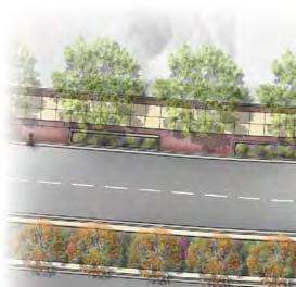
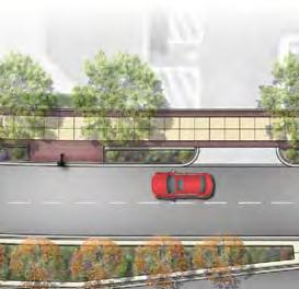
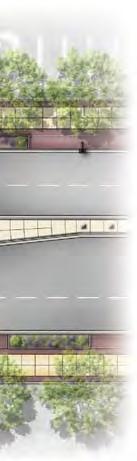
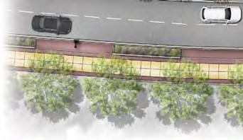

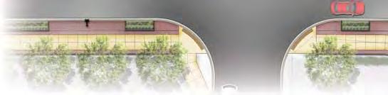
43 8-10 MULTIPURPOSE TRAIL AMENITY ZONE 67 ROADWAY 8-10 MULTIPURPOSE TRAIL AMENITY ZONE Blake Road Corridor Study Figure 10: Opportunities for Streetscaping
44 Blake Road Corridor Study Final Report Bicycle and Pedestrian Alternatives Alternatives Three alternatives were proposed for pedestrian and bicycle facilities in the corridor: on-road bike lanes with sidewalk, cycle track with sidewalk, and multipurpose trails. Each of these alternatives is illustrated in Figure 11. Under each of these alternatives approximately 20 feet on each side of the roadway is allocated to the bicycle and pedestrian facilities. The following sections describe the evaluation criteria and discuss performance of each alternative. Operations This criterion addresses travel time for bicycles and pedestrians in the entire corridor and delay for pedestrians and cyclists at intersections/crossings. The travel time in the corridor is a function of the driveways and side street entrances onto Blake Road as well as the number of signalized intersections on Blake Road. Bicyclists in an on-road bike lane will follow the same rules of the road as other vehicles; stopping at red lights and continuing through stop controlled side streets and driveways. With the cycle track and multipurpose trail alternatives, pedestrians and bicyclists would also stop at red lights at the signalized intersections and would have the right-of-way at the stop controlled side streets. However, bicyclists using the multi-purpose trail or cycle track would probably slow some at driveways and side streets to make sure there were not conflicts with the side street traffic. Because the multi-purpose trail would be two-way, bicyclists would not have to cross Blake Road to travel in the opposite direction. In summary, there are not significant advantages or disadvantages to any of the alternatives relative to this criterion. Because this section of Blake Road is relatively short the slight travel time advantage for on-road bike lanes is not considered significant. Bicycle facility safety and comfort for likely users Bicycle facility safety is related to the potential for conflicts and crashes between bicyclists and motor vehicles. All facilities have the potential for conflicts at intersections. On-street bike lanes would have the greatest potential for conflicts between intersections as there is not physical separation between bike and travel lanes. Multipurpose trails and cycle tracks would have less potential for conflict because they would provide physical separation between bicyclists and moving traffic. Because cycle tracks and multipurpose trails would be located further from the travel lane, there is potential for increased conflicts at intersections because motorists may have a more difficult time seeing a bicyclist riding on a trail or cycle track. 31
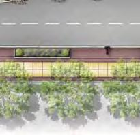
45 Multi-Purpose Trail Bike Lane and Sidewalk Cycle Track and Sidewalk Blake Road Corridor Study Figure 11: Pedestrian and Bike Facilities between Excelsior Boulevard and Highway 7
46 Blake Road Corridor Study Final Report Based on discussions at TAC meetings and input from the public, it is expected that bicyclists using the corridor will be less-experienced riders and families accessing the Cedar Lake Regional Trail and the future Southwest LRT station. With this understanding, the on-road bike lane alternative would not provide a comfortable facility for the expected bicycle users in the corridor. An on-street facility on a four-lane roadway is typically not comfortable for inexperienced bicyclists and families. The cycle track and multipurpose trail alternatives would provide a more comfortable facility for the expected types of bicyclists in the corridor. Pedestrian safety and comfort Pedestrian safety and comfort is influenced by several factors, including the number of conflict points, uncontrolled crossings, visibilities between modes, travel speeds, and interactions with motor vehicles and bicyclists. The greatest difference between the alternatives is related to separation between pedestrians, motor vehicles, and bicyclists. Facilities with greater separation from traffic are more comfortable and safe for pedestrians. Pedestrians are more comfortable walking on facilities that are separated from bicyclists, as the speed differential between pedestrians and bicyclists can create conflicts between users. The other potential difference between the alternatives is the amount of space available for plantings/landscaping/streetscaping. As shown in the proposed sections, the amount of space provided for plantings/landscaping/streetscaping is very similar among alternatives. The bike lane and cycle track alternatives would be more comfortable for pedestrians because bicyclists and pedestrians would have separate facilities and the sidewalk would be separated from travel lanes by over 11 feet. The multipurpose trail alternative would be less comfortable for pedestrians because they would share the trail with bicyclists. The multipurpose trail would also provide less separation between pedestrians and travel lanes. Bicycle facility directness and connections to destinations This criterion measures how easily a bicyclist can reach destinations on both sides of the corridor. All alternatives would provide bicycle facilities on both sides of the roadway. However, the bike lane and cycle track alternatives would provide one-way facilities, which would require some bicyclists to cross Blake Road twice to reach some destinations. The multipurpose trail alternative would provide better connections to destinations, as it would be a two-way facility. Economic development, right of way impacts, and construction costs Economic development, right of way impacts, and construction costs would be similar for all alternatives. Maintenance costs and ease of maintenance This criterion refers to the cost and ease of maintaining bicycle and pedestrian facilities through the winter. The bicycle lane alternative would be the easiest to maintain in the winter, as the bike lane could be plowed with the roadway. The sidewalk would need to be plowed separately. The cycle track and sidewalk alternative would result in the greatest maintenance costs, as both the cycle tracks and sidewalks would need to be plowed separately from the roadway. The 33
47 Blake Road Corridor Study Final Report multipurpose trail alternative would need to be plowed separately from the roadway, but maintenance costs would be lower than removing snow from both a cycle track and sidewalk. Maintenance of the off-street alternatives (multipurpose trail and cycle track) would result in better winter bicycling conditions than maintenance of the on-street bike lane. It can be challenging to effectively keep a bike lane clear of snow and ice because vehicles tend to pack down snow and ice in the bike lane. Environmental Impacts This criterion considers connections to existing amenities (Minnehaha Creek, Cottageville Park), stormwater management, green infrastructure, green space, impervious surfaces, and impacts to water quality, air quality, noise, and health. There are no real differences among the alternatives relative to these measures. Each of these alternatives can be developed to address the connections and stormwater management. The amount of impervious surface is going to be very similar especially since the buffer area on these alternatives is likely to be impervious surface. Conclusions The following table summarizes the scoring of the alternatives relative to the criteria. There is not a significant difference among the alternatives. Because of the type of bicycle users that are expected in this corridor (less experienced occasional users) the multi-purpose trail was slightly favored because the facility will require fewer crossings of Blake Road and it would physically separate the bicyclists from vehicles on the roadway. Criteria On-road Bike Lane Cycle Track Multi-purpose Trail Operations Bike Safety and Comfort Pedestrian Safety and Comfort Bike Facility Directness to Destinations Economic Development Right-of-way Impacts Construction Costs Maintenance Costs Environmental Impacts Total
48 Blake Road Corridor Study Final Report Other Alternatives Excelsior Boulevard to Railroad Crossing The primary alternative consideration in this section of the corridor is whether to leave the median open at the access to Westside Village apartments and access to the LRT station area development, as illustrated in Figure 12. A median break will require the addition of a second southbound left-turn lane at Excelsior Boulevard to provide adequate storage. It is also assumed that pedestrians will cross at this location even if there is no marked pedestrian crossing. If the median is closed at this access a separate marked pedestrian crossing would be provided south of the railroad tracks. The two alternatives were evaluated based on safety, construction costs, right of way impacts, access for all modes, and economic development. Closing the median would result in improved safety, but would reduce access for vehicles, pedestrians, and bicyclists. Pedestrians and bicyclists would need to travel out of their way to cross Blake Road at Excelsior Boulevard or the existing regional trail crossing. An open median with pedestrian crossing would preserve vehicle access, improve pedestrian and bicyclist connectivity, and support future economic development by preserving access in this location. Conclusion The recommendation at this location is to leave the median open at the Westside Village apartments since it would provide a more direct connection for pedestrians and would provide the necessary access for future development at this location. It is expected that if a marked crossing is provided it would be north of the median opening. Cedar Lake Regional Trail Crossing Grade Separated or At-Grade The alternatives being considered at this location address the need for a grade separation of the Cedar Lake Regional Trail and Blake Road as part of the Blake Road project. The focus of this analysis is on how this grade separated crossing would impact the goals for the Blake Road corridor rather than the impact on the use and safety of the Cedar Lake Regional Trail. This crossing is currently at-grade. The grade separated and at-grade crossing alternatives are shown on Figure 13. The alternatives were evaluated based on safety, construction costs, right of way impacts, and directness of bicycle and pedestrian connections. The grade separated option would improve safety for bicyclists and pedestrians. However, the construction costs and right of way impacts of this alternative are significantly higher than the at-grade crossing. The grade separated alternative would also require pedestrians and bicyclists to travel out of their way to cross Blake Road. Conclusion While the grade separated crossing may make sense from the standpoint of Cedar Lake trail users it would not provide much benefit for the users of the Blake Road corridor. As a result it is recommended the grade separation not be pursued as part of the Blake Road corridor project. If Three Rivers Park District would like to pursue the grade separation as a separate project the Blake Road project should be designed to allow for this option. 35


49 Open Median with Pedestrian Crossing Closed Median with Pedestrian Crossing near Railroad Tracks Option A Option B Blake Road Corridor Study Figure 12: Alternatives for Pedestrian Crossing Locations between Excelsior Boulevard and railroad tracks


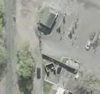
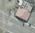


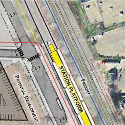
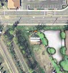
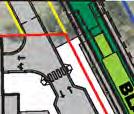

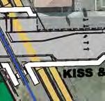
50 At-Grade Trail Crossing Grade-separated Trail Underpass Blake Road Corridor Study Figure 13: Alternatives for Cedar Lake Regional Trail Crossing
51 Blake Road Corridor Study Final Report Lake Street Pedestrian Crossing Two alternatives are considered for the pedestrian crossing at Lake Street: an at-grade crossing or grade-separated crossing along Minnehaha Creek, located underneath the Blake Road Bridge over the creek. Similar to the Cedar Lake Regional trail crossing evaluation the focus of this analysis is on how this grade separated crossing would impact the goals for the Blake Road corridor rather than the impact on the use and safety of a trail system along Minnehaha Creek. The alternatives were evaluated based on safety, construction costs, right of way impacts, and directness of bicycle and pedestrian connections. As at the regional trail crossing, a grade separated trail crossing along Minnehaha Creek would improve safety for pedestrians and bicyclists. However, the grade separated crossing at Minnehaha Creek would be more circuitous and less likely to be used for trips beginning or ending in the Blake Road corridor. The cost of constructing a grade separated trail crossing along Minnehaha Creek would be significant. To provide a trail underneath the Blake Road Bridge over Minnehaha Creek, the existing bridge would have to be raised by approximately 4 feet. Hiawatha Avenue access to Blake Road would need to be closed and Hiawatha Avenue would need to be rerouted to connect to Lake Street. Lake Street would need to be reconstructed adjacent to Blake Road to meet the new grade of the roadway and the bridge over Minnehaha Creek would need to be replaced. This could add $2 to $3 million of construction costs to the Blake Road project. Conclusion While the grade separated crossing may make sense from the standpoint of a trail system along Minnehaha Creek it would not provide much benefit for the users of the Blake Road corridor. Raising the bridge would result in significant impacts and design changes on Blake Road. As a result it is recommended the grade separation not be pursued as part of the Blake Road corridor project. Intersections at Lake and 2nd Streets The alternatives at the intersections of 2 nd Street and Blake Road and Lake Street and Blake Road address the best type of traffic control at these intersections. Traffic signals were compared with roundabouts at these intersections, as shown in Figure 14. These alternatives were evaluated based on traffic operations, safety and conflict points, pedestrian crossings, access, right of way impacts, environmental impacts, construction costs, and aesthetics. Conclusion The overall evaluation rates the alternatives as fairly equal. The roundabout is considered better relative to the pedestrian crossing, access and aesthetic criteria but will cost more, have more right-of-way impacts and more negatively impact the Cold Storage site and Minnehaha Creek. The roundabouts may also require a signal at 2 nd Street in order to prevent vehicle queues from blocking the intersection at 2 nd Street or queuing onto the railroad tracks. Therefore the signalized intersection at 2 nd Street is recommended as the preferred alternative in this area. 38


52 Signalized Intersection Roundabout Intersection Roundabouts at Lake & 2nd.dgn 10/8/ :06:24 AM Blake Road Corridor Study Figure 14: Alternatives for Intersections at Lake and 2nd Streets
53 Blake Road Corridor Study Final Report TH 7 Intersection The issue at TH 7 is whether to widen the Blake and Aquila approaches to TH 7 in order to add a second left-turn lane to provide more capacity, as shown in Figures 15a and 15b. Seven criteria were identified for evaluating alternatives for the intersection configuration: operations, safety and conflict points, pedestrian crossings, access, right of way impacts, construction costs, and environmental impacts. Additionally, a grade-separated pedestrian crossing of TH 7 was considered at this location. Conclusion Adding a second left-turn lane on the Blake Road and Aquila approaches to TH 7 would improve intersection traffic operations and safety. However, it would involve construction of retaining walls, some right-of-way acquisition, and the longer crossing of Blake Road would be less friendly for pedestrians and bicyclists. Because this intersection experiences the worst existing and projected traffic congestion in the corridor, it is recommended that dual left-turn lanes be installed at this location. There is little demand for pedestrian and bicycle crossings of Blake Road at this location. Preliminary designs for this intersection would shorten the crossing of TH 7 as compared to existing conditions. There is significant public support for adding a pedestrian bridge over TH 7 in this location. A pedestrian bridge would provide a much safer crossing of TH 7 for pedestrians and bicycles; however, it would result in significant property impacts and would screen adjacent properties. At this time it is not recommended to pursue a pedestrian bridge. Future consideration of a bridge should be coordinated with MnDOT to ensure that the bridge would not conflict with long-term plans for this intersection. Interlachen Boulevard to Excelsior Boulevard In this segment, additional roadway, bicycle, and pedestrian alternatives were not determined necessary to consider as part of the project. The existing two-lane roadway provides acceptable traffic operations and is expected to continue to provide adequate capacity for the future. The existing on-street bike lanes are appropriate for this section. Traffic volumes on this segment of Blake Road are low enough that most bicyclists are comfortable on this facility. A sidewalk on the west side of the road is proposed to meet the needs of pedestrians in this segment of Blake Road. TH 7 to 36th Street This segment of Aquila Avenue is currently a four-lane divided roadway with sidewalk on the east side of the road. There are no bicycle facilities in this segment. The existing roadway configuration is expected to provide adequate traffic operations in the future. Multipurpose trails are proposed on both sides of the road to provide for both pedestrians and bicyclists. 40
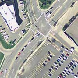
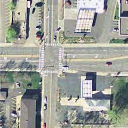
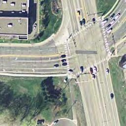
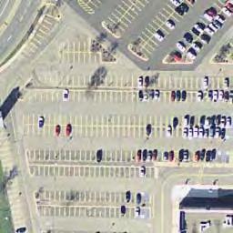
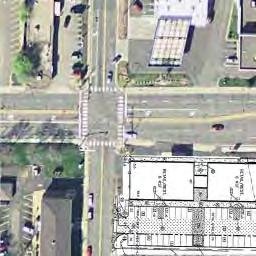
54 At-Grade Intersection- Dual Left Turn Lanes At-Grade Intersection- No Build Blake Road Corridor Study Figure 15a: Alternatives for Intersection at Highway 7
55 Grade Separated Pedestrian and Bicycle Crossing - East Side Grade Separated Pedestrian and Bicycle Crossing - West Side Blake Road Corridor Study Figure 15b: Alternatives for Intersection at Highway 7
56 Blake Road Corridor Study Final Report 7. Recommendations The evaluation of alternatives led to the following recommendations for the corridor. These recommendations are broken out by segment. Interlachen to Excelsior Boulevard Cross-section Figure 16 shows the preferred alternative for Interlachen to Excelsior Boulevard. The recommended cross-section in this segment has two lanes with on-road bike lanes and sidewalk on the west side. Sidewalk on West Side The primary improvement in this section is the addition of a sidewalk on the west side of Blake Road. The sidewalk would provide a facility for pedestrians from the residential areas south of Excelsior Boulevard, and provide connection to Excelsior Boulevard, the future Blake Road LRT station and other areas on Blake Road north of Excelsior Boulevard. Maintain existing bike lane on Blake Road It is recommended to maintain the existing bike lane on Blake Road south of Excelsior Boulevard. Existing and projected traffic volumes are low enough that the bike lane will continue to be a comfortable facility for many bicyclists. Excelsior Boulevard to TH 7 Cross-Section Figure 17 shows the preferred alternative for Blake Road between Excelsior Boulevard and TH 7. The recommended cross-section in this segment is a four lane divided roadway with multi-use trail on both sides of Blake Road. The roadway width in the proposed typical section was reduced by 6.8 feet from the roadway section that was initially considered. The purpose of reducing the roadway width is to help reduce speeds on Blake Road while maintaining the capacity needed in this section. The reduced roadway width was accomplished by narrowing through lanes from 11 feet to 10.8 feet and by narrowing the median by 6 feet. At locations where there are left turn lanes there would be no raised median. The space gained was added to the boulevard area increasing the boulevard from approximately 8 feet to 11 feet and increasing the separation between vehicle traffic and pedestrians and bicyclists. The 10 foot multi-use path on both sides of Blake Road will be a combined facility for bikes and pedestrians based on the feedback received from the public. The key public input was that bicyclists in this corridor are occasional and recreational users who are making shorter trips in the corridor and that both bicyclists and pedestrians do not want to cross Blake Road if they can avoid it. The multi-use path is two-way and does not require bikers to cross the roadway unless their destination is on the other side of the road. In general bicyclists along Blake Road will be traveling at lower speeds and present less conflict with pedestrians. 43
57 Spruce Rd Excelsior Blvd Blake Road Belmore Ln Boyce Rd Blake School Entr Maloney Ave Goodrich St Waterman Ave Int erl Blake Road Corridor Study ach en Blv d Figure 16: Preferred Alternative for Interlachen to Excelsior Boulevard
58 Cambridge Street Oxford St Hiawatha Ave 2nd e St Lak W E St N RT L ake rl da Ce Excelsior Blvd Blake Road Corridor Study Figure 17: Preferred Alternative from Excelsior Boulevard to Highway 7
59 Blake Road Corridor Study Final Report Urban Design Treatments Landscape and hardscape treatments were considered in this section during the evaluation phase to make sure that adequate space was provided to accommodate the urban design treatments that will create a friendly environment for pedestrians and bicyclists. Design and treatments along the boulevard and the multi-use trail will be developed further during the final design phase of this project. It is also recommended that the City of Hopkins consider zoning requirements for a green buffer strip between the multi-use trail and the adjacent properties to enhance the bicycle and pedestrian corridor and separate it from adjacent parking lots and buildings. It is also recommended that the overhead utilities in the corridor be put underground to further enhance the pedestrian and bicycle corridor. Excelsior Boulevard and Blake Road Intersection It is recommended to provide two southbound left turn lanes in order to provide adequate storage between the median opening at the West Side Village access and Excelsior Boulevard. Combined through and right-turn lanes on southbound Blake Road and northbound Blake Road are recommended in order to minimize crossing distance on Blake Road at the intersection. Minimize radius for right-turns on all approaches to intersection to reduce speed of right-turns and minimize pedestrian crossing distances. Median Opening at West Side Village Access It is recommended to provide full access to Blake Road at West Side Village to support the development associated with the Blake Road Station and the vitality of the West Side Village apartments. Pedestrian Crossing between Excelsior Boulevard and Railroad Tracks A marked pedestrian crossing with Rectangular Rapid Flashing Beacon (RRFB) is recommended north of the West Side Village Access where there is a full width median. This RRFB will be interconnected with the railroad crossing so that southbound vehicles are not trapped on the railroad tracks by the RRFB when a train is coming. This may require that the RRFB not activate when a train is within a selected distance from the Blake Road crossing. Railroad Crossing A railroad signal and gate arms will be provided at the railroad crossing with Blake Road. This signal and gate arms will be activated by both the freight trains and the light rail vehicles. This crossing will be the responsibility of the Southwest LRT project. Cedar Lake Trail Crossing Three Rivers Park District is proposing a grade separation at the Cedar Lake Regional Trail crossing of Blake Road. An at grade connection between the Cedar Lake Road Regional trail and the multi-use trail on either side of Blake Road will be maintained. It is recommended that no marked at grade crossing be provided where the Cedar Lake trail intersects with the Blake Road multi-use trail. Pedestrians and bicyclists crossing Blake Road would be encouraged to use either the Cedar Lake Trail underpass of Blake Road or the marked at grade crossings at 2 nd Street or just south of the railroad tracks. 46
60 Blake Road Corridor Study Final Report 2 nd Street Intersection The intersection of 2 nd Street and Blake Road will be a signalized intersection and will include pedestrian crossings. The 2 nd Street signal will be interconnected with the railroad signal so that northbound vehicles are not trapped on the railroad tracks when a train is coming and southbound vehicles do not back up into the intersection of 2 nd Street and Blake Road when the gate arms are down. The east approach of the 2 nd Street intersection will serve as the primary access for the Cold Storage site. Lake Street Intersection The intersection of Lake Street and Blake Road will have side street stop control. A marked pedestrian crossing with RRFB is recommended on the north side of the intersection. Longer term it is recommended that the Hiawatha Avenue intersection with Blake Road be closed and a connection from Hiawatha to Lake Street be provided. Minnehaha Creek Bridge It is recommended that the Minnehaha Creek Bridge be retained. The bridge is in good condition and can accommodate the proposed cross section. Oxford Street It is recommended that the median extend through the intersection of Oxford Street and Blake Road. Oxford Street would have right in and right out access on Blake Road. Businesses on the west side of Blake Road would also have right in and right out access. The boulevard between Blake Road and the multi-use trail will be reduced in this area in order to minimize right-of-way impacts. Cambridge Street No change in the lane configuration is proposed at this intersection. The intersection of Cambridge Street and Blake Road will be signalized. TH 7 The intersection of Blake Road/Aquila Avenue and TH 7 is recommended to be modified to add a second left turn lane for northbound left turns on Blake Road and southbound left turns on Aquila Avenue. In addition the southbound free right on Aquila Avenue will be modified so that right-turns are made closer to TH 7. Modification of the southbound free right will be completed as part of a separate MnDOT project. A right-turn lane will be added for southbound right turns. It is recommended that the radius on all corners of the intersection be reduced to reduce right turn speeds and minimize pedestrian crossing distances. TH 7 to 36th Street Cross-Section Figure 18 shows the preferred alternative for Aquila Avenue between TH 7 and 36th Street. The recommended cross-section in this segment is a four-lane divided roadway with multi-use trail on both sides of Aquila Avenue. The roadway section in this segment will have a minimum 4 median at left turn lanes, 10.8 foot through lanes, a 7 foot boulevard and an 8 foot trail. This section will require acquisition of some right-of-way. 47
61 36th St W 37th St W Blake Road Corridor Study Figure 18: Preferred Alternative from Highway 7 to 36th Street
62 Blake Road Corridor Study Final Report Urban Design Treatments No specific recommendations have been made regarding landscape or hardscape in this section 36 th Street Intersection This intersection is currently signalized and it is recommended that it be signalized in the future. It will have the same lane configuration as the current intersection. 37 th Street Intersection This intersection is currently signalized. A roundabout was considered as an alternative at this intersection. The City of St. Louis Park will continue to evaluate both alternatives for this intersection. Cost Estimate The estimated construction costs for the improvements are approximately $11.7 million in current dollars (2015). A 20% contingency is included in the construction costs. Table 2 provides a summary of the estimated costs broken out by the major project components and by agency. The estimate includes approximately $2.3 million for engineering and administration costs. The estimate does not currently include any costs for city utilities, undergrounding the overhead utilities or for right of way. The estimated construction costs are based on conceptual design and will change as more detail design is completed. 49
63 Table 2: Blake Road: Interlachen to 36th Street Project Cost Estimate Summary (Based on Preliminary Layout) Last Revision: 4/24/2015 IMPROVEMENT Hennepin county Hopkins Edina St. Louis Park TOTAL PROJECT CONSTRUCTION COST A Mobilization $ 472,000 $ 118,000 $ 50,000 $ 50,000 $ 740,000 B Removals $ 329,340 $ 6,250 $ 700 $ 54,450 $ 391,440 C Grading and Paving (E/S) $ 2,565,760 $ - $ - $ 1,029,530 $ 3,595,290 D Retaining Walls $ 1,104,000 $ - $ - $ 72,000 $ 1,176,000 E Box Culvert $ - $ - $ - $ - $ - F Storm Sewer 1 $ 384, $ 398, $ - $ 312,850 $ 1,095,594 G Subsurface Drains $ 2,180 $ - $ - $ 800 $ 2,980 H Sanitary Sewer 2 $ - $ - $ - $ - $ - I Water Main 2 $ - $ - $ - $ - $ - J Multi-use Path --Assumed to be Concrete $ 432,000 $ 21,600 $ 86,400 $ 51,000 $ 677,400 K Concrete Pavement & Curb and Gutter $ 218,550 $ - $ - $ 86,880 $ 305,430 L Traffic Control $ 121,000 $ - $ - $ 48,400 $ 169,400 M Signing/Striping $ 53,490 $ - $ - $ 21,565 $ 75,055 N Traffic Signals 4 $ 549,000 $ 262,500 $ - $ 56,250 $ 867,750 O Turf Establishment/Erosion Control $ 77,600 $ - $ - $ 40,708 $ 118,308 P Lighting $ 100,000 $ 100,000 $ - $ 30,000 $ 230,000 Q Landscaping $ 125,000 $ 125,000 $ - $ 25,000 $ 275,000 R Building Demolition $ - $ - $ - $ - $ - S Contingency (20%) $ 1,306,928 $ 206,275 $ 27,420 $ 375,887 $ 1,943,929 CONSTRUCTION COST SUBTOTAL $ 7,841,566 $ 1,237,651 $ 164,520 $ 2,255,319 $ 11,663,576 T Engineering / Administration (20%) $ 1,568,313 $ 247,530 $ 32,904 $ 451,064 $ 2,332,715 TOTAL COST $ 9,409,879 $ 1,485,181 $ 197,424 $ 2,706,383 $ 13,996,291 NOTES: 1. Storm Sewer Costs were split 50% County and 50% City 2. Sanitary Sewer and Watermain are not estimated 3. Multi-use path was assumed as replacement of existing sidewalks 4. County assumed to have 3 legs at Excelsior, 2 legs at 2nd and 2 legs at Cambridge and 1 leg at TH 7, Hopkins has 1 leg at Excelsior, 2 legs at 2nd and 2 legs at Cambridge General Note: Right-of-way costs are not included.
64 Blake Road Corridor Study Final Report 8. Next Steps The recommendations in this study represent a concept design for the corridor that addresses the goals of the various stakeholders. There is significant additional design that is required before final costs and right of way can be determined. Additional study is needed of the utilities in the corridor to determine what should be replaced and the location for the utilities. As indicated earlier more detail also needs to be developed for the urban design elements of the corridor. The next step in the engineering process is to complete final design for the corridor which will help establish final construction limits and right of way needs. The urban design should also be addressed during the development of final plans. Environmental Review This project is subject to state environmental regulations and potentially subject to federal environmental regulations depending on the funding sources. If federal funding is secured for the project a Federal Project Memorandum or Environmental Assessment will be needed. A state Environmental Assessment Worksheet should also be completed. There is also potential for 4(f) and 6(f) impacts associated with the road in the area of Cottageville Park. The environmental review would determine potential environmental impacts and identify appropriate mitigation measures. Funding Sources A variety of funding sources will be utilized to construct this project. Local funding sources could include: City of Hopkins: Local utilities and undergrounding of overhead utilities on Blake Road between Excelsior Boulevard and TH 7 City of St. Louis Park: Aquila Avenue Improvements City of Edina: Sidewalk improvements in Edina Hennepin County: Blake Road between Excelsior Boulevard and TH 7 MnDOT: TH 7 intersection Potential for Cooperative Agreement Funds In addition, federal funding sources will be pursued and could include: TIGER Grant: Federal funding for multi-modal transportation projects that generate economic development and improve access to reliable, safe, and affordable transportation. The minimum federal funding per project is $10 million. Transportation Alternatives Program: Federal funds administered through the Metropolitan Council that could be used for multi-use trail and aesthetic enhancements. Coordination with other projects The design of this project needs to be coordinated with several other projects that will be designed and potentially constructed in the same time frame. This includes: Southwest LRT and Blake Road Station Area Cedar Lake Regional Trail grade separation 51
65 Blake Road Corridor Study Final Report Cold Storage Site Development Plans Highway 7 intersection improvements City of Hopkins local street reconstruction 52
66 Blake Road Corridor Study Final Report Appendix Blake Road Corridor Study Alternatives Evaluation Memo 53

67 Memorandum (Draft) engineering planning environmental construction 701 Xenia Avenue South Suite 300 Minneapolis, MN Tel: Fax: To: Nate Stanley, PE City of Hopkins From: Tony Heppelmann, PE WSB & Associates Date: November DRAFT 18, 2014 Re: Blake Road Corridor Study Evaluation of Alternatives WSB Project No This memorandum discusses the evaluation of alternatives considered for improvements to Blake Road between CSAH 3 and TH 7 in Hopkins. It does not apply to the sections in Edina or St. Louis Park. It provides a discussion of the assumptions used to evaluate alternatives based on the evaluation criteria reviewed by the project Technical Advisory Committee (TAC) in July 2014 and comments received since the last TAC meeting in October, Alternatives Considered The following alternatives were identified as potential improvements to address the goals and objectives of the Blake Road Corridor Study. Alternatives are grouped into three categories: Roadway, Pedestrian and Bicycle Facilities, and Other Alternatives. Different evaluation criteria apply to each category. The following alternatives are discussed below in the Evaluation Criteria section. Roadway Alternatives between CSAH 3 and TH 7 Three-lane Center left-turn lane and right-turn lanes (47 feet curb face to curb face) Four-lane No separate turn lanes (48 feet curb to curb) Five-lane Center left-turn lane with no median and no right-turn lane (59 feet) Four-lane Divided Median with left-turn lanes and no right-turn lane (66 feet) Pedestrian and Bicycle Facilities between CSAH 3 and TH 7 On-road bike lanes Cycle track plus sidewalk Multipurpose trails St. Cloud Minneapolis St. Paul Equal Opportunity Employer wsbeng.com
68 Mr. Nate Stanley November 18, 2014 Page 2 Other Alternatives Excelsior Boulevard to Railroad Crossing Median break at Westside Village apartment access for both vehicles and pedestrians Median break at Westside Village apartment access for pedestrians only Median break immediately south of railroad crossing No median break Cedar Lake Regional Trail Crossing At grade crossing Grade separated Lake Street Pedestrian Crossing At-grade crossing Grade separated crossing Intersections at Lake and 2nd Streets Signalized intersections Roundabouts Intersection at TH 7 At-grade intersection Grade separated interchange DRAFT Evaluation of Alternatives The following sections provide a brief summary of the alternatives and discusses the performance of each alternative relative to each of the evaluation criterion. At the end of the discussion is a numerical summary of the relative performance of the alternatives against that criterion. The numerical summary is based on a scoring range of 1 through 5 with the higher score representing better performance. The ratings try to capture the relative differences among the alternatives. At the end of the evaluation is a conclusion section that provides a summary table and recommendation on the preferred alternative for that category or area. Roadway Alternatives Four different roadway sections were evaluated for the section of Blake Road from Excelsior Boulevard to TH 7. The alternatives evaluated are: Three-lane Center left-turn lane and right-turn lanes (47 feet curb to curb) Figure 1 Four-lane undivided No separate turn lanes (48 feet curb to curb) Figure 2
69 Mr. Nate Stanley November 18, 2014 Page 3 Five-lane Center left-turn lane with no median and no right-turn lane (59 feet curb to curb) Figure 3 Four-lane Divided -- Median with left-turn lanes and no right-turn lane (66 feet curb to curb) Figure 4 Seven different criteria were identified for evaluating the roadway alternatives for Blake Road between CSAH 3 and TH 7. Economic development was added as an eighth criterion. Operations This criterion measures the ability to provide sufficient capacity for the existing and forecast volumes on Blake Road. A capacity analysis of the existing signalized intersections on Blake Road was completed for both the existing and forecast am and pm peak hour volumes to determine vehicle delay, level of service and queue lengths with the current lane geometry. The signalized intersections on Blake Road include Excelsior Boulevard, 2 nd Street, Cambridge Street, TH 7, 37 th Street, and 36 th Street. The results of that analysis are shown on Table 1. TH 7 The Blake Road and TH 7 intersection currently operates at LOS E in the PM peak hour and is forecast to operate at LOS F in the PM peak hour in 2035 without any improvements at the intersection. The back-ups from the TH 7 intersection are forecast to spill back into the intersection of Blake Road and Cambridge Street and will cause that intersection to operate at LOS E in Excelsior Boulevard The other intersection that currently has some movements at LOS D is the Excelsior and Blake Road intersection. An analysis was completed to determine if the number of lanes on Blake Road at this intersection could be reduced to provide a three-lane section on Blake Road north of the intersection and still maintain an acceptable LOS (LOS D or better). This would require reducing southbound Blake Road to one through lane, reducing eastbound Excelsior Boulevard to a single left-turn lane, and reducing northbound Blake Road to a single through lane. The purpose of this analysis was to determine whether acceptable traffic operations could be maintained at this intersection if Blake Road was reduced to a single through lane in each direction north of Excelsior Boulevard. The analysis shows that the intersection would operate at LOS E in the pm peak hour in 2035 with some individual approaches at LOS F. See Table 2. DRAFT 2nd Street An analysis was also completed at the 2 nd Street and Blake Road intersection assuming only one through lane in each direction. The analysis shows this intersection would operate at LOS E in the pm peak hour in 2035 with some individual approaches operating at LOS F under this option. In addition to the overall level service this analysis showed that with a single through lane in each direction on Blake Road, the queues on Blake Road would extend
70 Mr. Nate Stanley November 18, 2014 Page 4 back through adjacent intersections further degrading the level of service on the roadway and creating extremely long delays on side-streets such as Lake Street. As result of the analysis it was concluded that two through lanes in each direction are required which eliminates the three-lane alternative. The poor level of service for vehicles under these alternatives also impacts vehicle safety and pedestrian and bicycle safety. Even though the distance that pedestrians and bicycles must cross will be less with the three-lane alternative, due to long vehicle queues at unsignalized intersections there will not be gaps in the traffic for pedestrians and bicyclists to cross. The operations analysis of the four-lane undivided alternative shows that it would provide enough capacity for traffic between the railroad tracks and Cambridge Avenue to maintain LOS D or better operations. Left and right turn lanes are needed at Excelsior Boulevard, Cambridge Avenue and TH 7 in order to maintain an acceptable level of service. The four-lane divided and five-lane alternatives would provide adequate capacity for the future and better intersection operations than the other alternatives as shown in Table 1. Operations Summary: Three-Lane Alternative Fails to provide enough capacity to accommodate forecast 2035 traffic. Score: 1 Four-Lane Alternative Provides acceptable capacity at 2 nd, but not at Excelsior, Cambridge, and TH 7. Score: 2 Four-Lane Divided and Five-Lane Alternatives Provides acceptable traffic operations at all intersections except at TH 7. Score: 4 Safety DRAFT This criterion measures whether the alternative will reduce crashes and conflicts on Blake Road. Rear end, right angle, and side swipe crashes are the three most common crash types on this segment of Blake Road. The roadway alternatives were evaluated based on their potential to reduce these types of crashes. Three-lane roadway The three-lane roadway alternative would potentially reduce rear end crashes because it provides turn lanes at intersections. However, this alternative may result in an increase in right angle crashes because vehicles entering Blake Road from side streets would have fewer gaps in traffic and much longer delays than currently exist. As a result, a driver may try to take shorter gaps in traffic in order to cross or turn left onto Blake Road. In addition the long queues and delays may cause traffic to run red lights to reduce their travel time in the corridor.
71 Mr. Nate Stanley November 18, 2014 Page 5 Four-lane undivided roadway The four-lane undivided alternative has the least crash-reduction potential. Four-lane roadways tend to have higher crash rates than other roadway designs, particularly related to rear end and side swipe crashes. The four lane undivided roadway alternative will also have more delays and congestion than the five-lane and four-lane divided roadway alternatives resulting in potentially more violations of yellow and all red signal phases. Five-lane roadway The five-lane alternative is very similar to existing conditions on Blake Road and is not likely to reduce crash rates in the corridor. As traffic volumes increase crashes have the potential to increase given the amount of access on the corridor. Four-lane divided roadway The four-lane divided alternative would provide turn lanes to reduce rear end crashes. Additionally, the median would provide space to create pedestrian and bicycle refuge medians to reduce the likelihood of crashes involving pedestrians and bicyclists. Safety Summary Three-Lane Alternative High levels of congestion will increase crashes. Score: 2 Four-Lane Alternative Lack of turn lanes and moderate congestion will increase crashes. Score: 2 Five-Lane Alternatives Provides turn lanes and maintains acceptable traffic operations but lack of medians at intersections would create potential conflicts at intersections. Score: 3 Four-Lane Divided Provides turn lanes and medians which help to reduce rear end and right-angle crashes. Score: 5 DRAFT Pedestrian Crossings This criterion measures how well the alternative provides safe and direct pedestrian crossings. Shorter pedestrian crossing distances are generally safer for pedestrians, as pedestrians spend less time exposed to the risk of a crash with a vehicle. Medians can also improve safety by providing pedestrian refuge at intersections so that pedestrians can cross the roadway in two stages. Three-lane roadway The three-lane alternative provides the shortest pedestrian crossing distance. Pedestrian refuge medians could be installed in mid-block locations where turn-lanes are not needed and the center left turn lane could be replaced by a median. However, traffic operations analysis of the three-lane alternative shows that this alternative will have long queues that block intersections and cross-walks, making it challenging for pedestrians to cross at both signalized and unsignalized intersections. Traffic will also experience long delays which will
72 Mr. Nate Stanley November 18, 2014 Page 6 increase running of yellow and all red signal phases, creating safety problems for pedestrians crossing at signalized intersections. Four-lane undivided roadway A four-lane undivided roadway provides a shorter pedestrian crossing than the four-lane divided and five-lane alternatives. However, pedestrian crossings of four lane roadways are challenging because there are not opportunities for pedestrian refuge medians. Pedestrians must cross traffic traveling in both directions at one time. Five-lane roadway The five-lane roadway presents challenges for pedestrian crossings, as the roadway is wider than the three- and four-lane undivided alternatives. However, it is possible to provide refuge medians in locations where turn lanes are not needed. Four-lane divided roadway The four-lane divided alternative is wider than the three-lane and four-lane divided alternative; however, the median can be used as a refuge for pedestrians at both intersection and mid-block locations. The median provides a refuge so that pedestrians crossing the roadway only have to cross one direction of traffic at a time. Pedestrian Crossings Summary: Three-Lane Alternative Long queues and high level of congestion will make crossing difficult; however, the crossing distance is minimized and some refuge medians could be provided. Score: 3 Four-Lane Alternative Lack of medians and moderate levels of congestion will make crossing difficult. Score: 2 Five-Lane Alternative Wider crossing with no refuge area at locations with turn lanes. Score:2 Four-Lane Divided Wider crossing distances but median refuge area can be provided. Score: 4 DRAFT Business and Residential Access This criterion measures how well the alternative provides for business and residential access along Blake Road. The existing roadway design provides full business and residential access at most mid-block locations. The three-lane, four-lane and five-lane alternatives would preserve full access to businesses and residences along the corridor that exists today. The congestion and queues that are forecast with the three-lane alternative would make access to business and residences more difficult because of the intersection delays and because vehicle queues will block driveway access points. The four-
73 Mr. Nate Stanley November 18, 2014 Page 7 lane alternative would preserve access to businesses and residences, but left turn access to midblock locations can be challenging without a center left turn lane. The four-lane divided alternative would change access to right-in/right-out at up to four businesses. Businesses would still have indirect access through U-turns at signalized intersections. Businesses and Residential Access Summary: Three-Lane Alternative Provides full access to all adjacent properties but long queues and high level of congestion will make access difficult. Score: 3 Four-Lane Undivided Alternative Provides full access to all adjacent properties but lack of turn-lanes will make turning off or onto Blake Road difficult. Score: 3 Five-Lane Alternative Provides full access to all adjacent properties and provides a refuge area for vehicles. Score: 4 Four-Lane Divided Restricts access to several properties to right-in and right-out but with U-turns full access on Blake Road could be maintained. Score: 2 Right of Way Impacts This criterion measures the right of way impact of each roadway alternative. Alternatives that require less right of way will have lower right of way acquisition costs and fewer impacts to adjacent properties. The pedestrian and bicycle amenity zone will be approximately 20 feet on either side of the proposed roadway and therefore add about 40 feet of width to the overall crosssection. The existing roadway and sidewalk section between Excelsior Boulevard and TH 7 varies but is approximately 84 feet in width. The right-of-way varies from 84 feet just south of Cambridge to 112 feet south of TH 7. North of TH 7, the right-of-way is as narrow as 72 feet in locations. South of the Minnehaha Creek Bridge the right-of-way is between 90 and 94 feet. Three-lane roadway DRAFT The three-lane roadway cross-section would be approximately 47 feet in width and the total right-of-way width would be 87 feet. This would generally fit within the existing right-ofway between Excelsior Boulevard and TH 7. Four-lane undivided roadway The cross-section for the four-lane alternative would be approximately 48 feet in width and the total right-of-way width would be 88 feet. This would generally fit within the existing right-of-way between Excelsior Boulevard and TH 7. Five-lane roadway The five lane alternative would have a cross-section of approximately 59 feet and total rightof-way width of 99 feet. This section would require about 5 to 10 feet of right-of-way south of Minnehaha Creek. North of the creek it may be necessary to narrow the median and boulevards to avoid total takes.
74 Mr. Nate Stanley November 18, 2014 Page 8 Four-lane divided roadway The four-lane divided alternative would have a cross-section of approximately 66 feet and a total right-of-way of 106 feet. This section would require about 12 to 17 feet of right-of-way south of Minnehaha Creek. North of the creek it may be necessary to narrow the median and boulevards to avoid total takes. Right of Way Impacts Summary: Three-Lane Alternative Minimal right-of-way needs. Score: 4 Four-Lane Alternative Minimal right-of-way needs. Score: 4 Five-Lane Alternative Needs approximately 5 to 10 foot strip of right-of-way but can be minimized in critical areas. Score: 3 Four-Lane Divided Needs approximately 12 to 17 foot strip of right-of-way but can be minimized in critical areas. Score: 2 Construction Cost Typical construction cost for an urban arterial is approximately 200 dollars per lane foot in a corridor like Blake Road. This would include storm sewer, utility relocations and complete roadway reconstruction. Bridge replacement, retaining walls, median treatments, urban streetscape improvements and other unique features would be in addition to this amount. The distance between Blake Road and TH 7 is approximately 4000 feet. Based on these general rule of thumb costs the roadway alternatives would have the following costs. Construction Cost Summary: Three-lane alternative -- $2,400,000 Score: 4 Four-lane undivided alternative -- $3,200,000 Score: 3 Five-lane alternative -- $4,000,000 Score: 2 Four-lane divided alternative --$4,400,000 Score: 1 DRAFT Environmental Impacts Several measures were suggested for measuring the potential environmental benefits or impacts of the project relative to this criterion. These measures included: o Connections to existing amenities Minnehaha Creek, Cottageville Park o Stormwater Management o Green Infrastructure o Green Space o Impervious Surfaces Build vs. No-build o Impacts to water quality, air quality, noise, and health
75 Mr. Nate Stanley November 18, 2014 Page 9 For many of these criteria the number of lanes will not determine how well the project addresses these criteria. For example, connections to existing amenities will not be affected by the number of lanes. On the other hand as the number of lanes increases there is more impervious surface and less room available for green infrastructure. In this regard the environmental impacts will vary with the overall cross-section and right-of-way needs. In general, alternatives with greater right of way requirements are assumed to have greater environmental impacts. The three-lane alternative would have the least environmental impacts while the four-lane divided alternative would have the greatest environmental impacts. Alternatives were scored the same for this criterion as they were for the right-of-way criterion. Environmental Impacts Summary Three-Lane Alternative Needs approximately 4 foot strip of right-of-way. Score: 4 Four-Lane Alternative Needs approximately 4 foot strip of right-of-way. Score: 4 Five-Lane Alternative Needs approximately 15 foot strip of right-of-way but can be minimized in critical areas. Score: 3 Four-Lane Divided Needs approximately 22 foot strip of right-of-way but can be minimized in critical areas. Score: 2 Economic Development This criterion measures the ability of the roadway to accommodate the cities economic development goals for the project. Some of the measures that were suggested as measures of the impact on economic development included the following: DRAFT o Ability of roadway to accommodate forecast traffic o Access to existing businesses Build vs. No-build o Alignment with city s vision for pedestrian-oriented redevelopment, higher density, certain type of urban design o Amount of R/W acquisition space left for actual redevelopment o Placemaking - feel and character of public space o Level of public amenities (streetscape, etc.) o Infrastructure to support future housing market rate housing Measures related to placemaking, level of public amenities, and alignment with city s vision for pedestrian-oriented redevelopment are more dependent on the level of investment made in the amenity zones rather than the number of lanes. A higher density urban development will create more traffic that should be accommodated at a reasonable level of service. A highly congested corridor with long vehicle queues and stop and go traffic will not be an attractive location for residential development. Therefore in scoring this criterion it was assumed that alternatives that provided acceptable traffic operations levels were better than those that did not. Although the
76 Mr. Nate Stanley November 18, 2014 Page 10 need for additional right-of-way could limit the space available for actual redevelopment the additional area needed for the roadway corridor is very small compared to the total land area available for development. Economic Development Summary Three-Lane Alternative Does not accommodate corridor traffic volumes resulting in long delays, long queues, and discouraging investment. Score: 2 Four-Lane Alternative Does not accommodate corridor traffic volumes resulting in long delays, long queues, and discouraging investment. Score:2 Five-Lane Alternatives Meets corridor traffic needs and maximizes business access. Score: 4 Four-Lane Divided Meets corridor traffic needs. Score: 5 Conclusion The results of this evaluation are summarized in the following table. The table shows that the five-lane and four-lane divided alternatives have similar results. The three-lane alternative and the four-lane alternative would be difficult to implement because they perform poorly relative to the safety and operations standards required for state-aid and much of the federal aid funding sources. The four-lane divided cross-section is the recommended roadway cross-section for this corridor. The width and locations of medians should be developed to minimize the right-of-way needs and to maintain reasonable business access. DRAFT Roadway Alternatives Criteria 3-Lane 4-Lane 5-Lane 4-lane Divided Operations Safety Pedestrian Crossings Business and Residential Access Right-of-Way Impacts Construction Cost Environmental Impacts Economic Development Total Score
77 Mr. Nate Stanley November 18, 2014 Page 11 Bicycle and Pedestrian Alternatives Alternatives The following three alternatives were proposed for accommodating pedestrians and bicyclists in the corridor. Each of these alternatives are illustrated on the figures on the following page. On-road bike lanes Figure 5 Cycle track plus sidewalk Figure 6 Multipurpose trails Figure 7 Under each of these alternatives approximately 20 feet on each side of the roadway is allocated to the bike and pedestrian facilities. Seven different criteria were originally identified for evaluating the bicycle and pedestrian alternatives for Blake Road between CSAH 3 and TH 7. One additional criterion was identified in later review. The following sections describe the evaluation criteria and discuss performance of each alternative. Operations This criterion was suggested as an additional criterion to evaluate the bicycle and pedestrian alternatives. The two measures that were suggested were the travel time for bicycles and pedestrians in the entire corridor and delay for pedestrians and cyclists at intersections/crossings. The travel time in the corridor is a function of the driveways and side street entrances onto Blake Road as well as the number of signalized intersections on Blake Road. Bicyclists on an on-road bike lane will follow the same rules of the road as other vehicles; stopping at red lights and continuing through stop controlled side streets and driveways. With the cycle track and multipurpose trail alternatives, pedestrians and bicyclists would also stop at red lights at the signalized intersections and would have the right-of-way at the stop controlled side streets. However, bicyclists using the multi-purpose trail or cycle track would probably slow some at driveways and side streets to make sure there were not conflicts with the side street traffic. Because the multi-purpose trail would be two-way, bicyclists would not have to cross Blake Road to travel in the opposite direction. Operations Summary In summary, there are not significant advantages or disadvantages to any of the alternatives relative to this criterion. Because this section of Blake Road is relatively short and not a high commuter bicyclist route the slight travel time advantage for on-road bike lanes is not considered significant. On-road bike lanes - Score: 4 Cycle track plus sidewalk Score: 3 DRAFT
78 Mr. Nate Stanley November 18, 2014 Page 12 Multipurpose trails Score: 3 Bicycle facility safety and comfort for likely users Two measures were suggested for this criterion; number of conflict points and number of uncontrolled crossings. Bicycle facility safety is related to the potential for conflicts and crashes between bicyclists and motor vehicles. All facilities have the potential for conflicts at intersections. On-street bike lanes On-street bike lanes would have the greatest potential for conflicts between intersections as there is not physical separation between bike and travel lanes. Multipurpose trail and cycle track Multipurpose trails and cycle tracks would have less potential for conflict because they would provide physical separation between bicyclists and moving traffic. Because cycle tracks and multipurpose trails would be located further from the travel lane, there is potential for increased conflicts at intersections because motorists may have a more difficult time seeing a bicyclist riding on a trail or cycle track. Based on discussions at TAC meetings and input from the public, it appears that bicyclists using the corridor will be less-experienced riders and families accessing the Cedar Lake Regional Trail and the future Southwest LRT station. With this understanding, the on-road bike lane alternative would not provide a comfortable facility for the expected bicycle users in the corridor. An onstreet facility on a four-lane roadway is typically not comfortable for inexperienced bicyclists and families. The cycle track and multipurpose trail alternatives would provide a more comfortable facility for the expected types of bicyclists in the corridor. Bicycle Facility Safety and Comfort Summary On-road bike lanes: Score: 3 Cycle track plus sidewalk: Score: 5 Multipurpose trail: Score: 5 Pedestrian safety and comfort The following measures were suggested for evaluating the pedestrian and bicycle facilities relative to this criterion. o Number of conflict points o Number of uncontrolled crossings o Visibility between modes and sightlines o Length of pedestrian crossings DRAFT
79 Mr. Nate Stanley November 18, 2014 Page 13 o Delay for pedestrians at crossings o Phasing of signals any priority for pedestrians? o Type of buffer from traffic lanes o Distance of pedestrian facilities from curb o Maintenance of pedestrian space snow storage/removal o Speed limit on roadway o Level of traffic calming measures included in roadway design o Longest distance between designated crossings o Treatment of pedestrian crossings at intersections o Treatment of pedestrian crossings at driveways/curb cuts o Lighting/illumination of crosswalks and pedestrian spaces o Amount of refuge space for pedestrians o Number of lanes required to cross at one time o Amount of space available for plantings/landscaping The proposed pedestrian facilities are the same for the on-road bike lane and cycle track with sidewalk alternative in that a sidewalk is provided on both sides of the roadway. The multi-use trail alternative combines the pedestrian and bicycle facilities but the facilities still cross the same roadways and serve the same areas. Therefore there is no difference between the alternatives relative to most of the measures listed above. The greatest difference between the alternatives relative to this criterion is related to separation between pedestrians, motor vehicles, and bicyclists. Facilities with greater separation from traffic are more comfortable and safe for pedestrians. Pedestrians are more comfortable walking on facilities that are separated from bicyclists, as the speed differential between pedestrians and bicyclists can create conflicts between users. The other potential difference between the alternatives is the amount of space available for plantings/landscaping/streetscaping. As shown in the proposed sections the amount of space provided for plantings/landscaping/streetscaping is very similar among alternatives. The bike lane and cycle track alternatives would be more comfortable for pedestrians because bicyclists and pedestrians would have separate facilities and the sidewalk would be separated from travel lanes by over 11 feet. The multipurpose trail alternative would be less comfortable for pedestrians because they would share the trail with bicyclists. The multipurpose trail would also provide less separation between pedestrians and travel lanes. Pedestrian Safety and Comfort Summary On-road bike lanes: Score: 5 Cycle track plus sidewalk: Score: 5 Multipurpose trails: Score: 4 DRAFT
80 Mr. Nate Stanley November 18, 2014 Page 14 Bicycle facility directness and connections to destinations This criterion measures how easily a bicyclist can reach destinations on both sides of the corridor. All alternatives would provide bicycle facilities on both sides of the roadway. However, the bike lane and cycle track alternatives would provide one-way facilities, which would require some bicyclists to cross Blake Road twice to reach some destinations. The multipurpose trail alternative would provide better connections to destinations, as it would be a two-way facility. Bicycle facility directness summary On-road bike lanes: Score: 3 Cycle track plus sidewalk: Score: 3 Multipurpose trails: Score: 5 Economic development The following measures were suggested for evaluating the pedestrian and bicycle facilities relative to this criterion. o Access to existing businesses Build vs. No-build o Alignment with city s vision for pedestrian-oriented redevelopment, higher density, and buildings with urban design following TOD principles (buildings fronting street, parking on rear or structured, active uses on street level, etc.) o Amount of R/W acquisition space left for actual redevelopment o Placemaking feel and character of public space o Level of public amenities o Infrastructure to support future housing market rate housing There are no real differences among the alternatives relative to these measures. The level of public amenities does not depend on the alternative selected. Economic Development Summary On-road bike lanes: Score: 3 Cycle track plus sidewalk: Score: 3 Multipurpose trails: Score: 3 DRAFT Right of way impacts This criterion measures the right of way impact of each bicycle and pedestrian facility alternative. Alternatives that require less right of way will have lower right of way acquisition costs and fewer impacts to adjacent properties. The right of way widths listed below are the total widths required for the on- and off-street bicycle and pedestrian facilities. The alternatives have very similar right-of-way needs. Forty feet of right of way (20 feet on both sides) would be needed for each of the alternatives.
81 Mr. Nate Stanley November 18, 2014 Page 15 Right of way impacts summary On-road bike lanes: Score: 3 Cycle track plus sidewalk: Score: 3 Multipurpose trails: Score: 3 Construction costs Construction costs for all of the alternatives would be fairly similar and will depend on the details of the amenities that are provided. The level of amenities that can be provided is very similar among alternatives. Construction costs summary On-road bike lanes: Score: 3 Cycle track plus sidewalk: Score: 3 Multipurpose trails: Score: 3 Maintenance costs and ease of maintenance This criterion refers to the cost and ease of maintaining bicycle and pedestrian facilities through the winter. The bicycle lane alternative would be the easiest to maintain in the winter, as the bike lane could be plowed with the roadway. The sidewalk would need to be plowed separately. The cycle track and sidewalk alternative would result in the greatest maintenance costs, as both the cycle tracks and sidewalks would need to be plowed separately from the roadway. The multipurpose trail alternative would need to be plowed separately from the roadway, but maintenance costs would be lower than removing snow from both a cycle track and sidewalk. Maintenance of the off-street alternatives (multipurpose trail and cycle track) would result in better winter bicycling conditions than maintenance of the on-street bike lane. It can be challenging to effectively keep a bike lane clear of snow and ice because vehicles tend to pack down snow and ice in the bike lane. Maintenance summary On-road bike lanes: Score: 3 Cycle track plus sidewalk: Score:2 Multipurpose trails: Score: 3 DRAFT Environmental Impacts The following measures were suggested for evaluating the pedestrian and bicycle facilities relative to this criterion: o Connections to existing amenities Minnehaha Creek, Cottageville Park
82 Mr. Nate Stanley November 18, 2014 Page 16 o Stormwater Management o Green Infrastructure o Green Space o Impervious Surfaces Build vs. No-build o Impacts to water quality, air quality, noise, and health There are no real differences among the alternatives relative to these measures. Each of these alternatives can be developed to address the connections and stormwater management. The amount of impervious surface is going to be very similar especially since the buffer area on these alternatives is likely to be impervious surface. Environmental impacts summary On-road bike lanes: Score: 3 Cycle track plus sidewalk: Score:3 Multipurpose trails: Score: 3 Conclusions The following table summarizes the scoring of the alternatives relative to the criteria. There is not a significant difference among the alternatives. Because of the type of bicycle users that are expected in this corridor (less experienced occasional users) the multi-purpose trail was slightly favored because the facility will require fewer crossings of Blake Road and it would physically separate the bicyclists from vehicles on the roadway. Bike and Pedestrian Facility Alternatives Evaluation Summary DRAFT Alternatives Criteria On-road Bike Lane Cycle Track Multipurpose Trail Operations Bike Safety and Comfort Pedestrian Safety and Comfort Bike Facility Directness to Destinations Economic Development Right-of-way Impacts Construction Costs Maintenance Costs Environmental Impacts Total
83 Mr. Nate Stanley November 18, 2014 Page 17 CSAH 3 to Railroad Crossing Open or closed median at Westside Village The primary alternative consideration in this section of the corridor is whether to leave the median open at the access to Westside Village apartments and access to the LRT station area development. A median break will require the addition of a second southbound left-turn lane at Excelsior Boulevard to provide adequate storage. It is also assumed that pedestrians will cross at this location even if there is no marked pedestrian crossing. If the median is closed at this access a separate marked pedestrian crossing would be provided south of the railroad tracks. Five different criteria were identified for evaluating alternatives for the median break between CSAH 3 and the railroad crossing. The following sections describe the evaluation criteria and discuss performance of each alternative. Safety This criterion relates to the safety of mid-block pedestrian crossings and vehicular access to midblock businesses and apartment buildings. The alternative that does not provide a median break would be the safer alternative since it reduces the number of conflict points and the amount of information that a pedestrian would be required to process in order to make a safe crossing. With the median closure the pedestrian crossing can be made farther from the intersection with CSAH 3 and pedestrians would have a safe refuge area between the northbound and southbound traffic. Providing a median break at Westside Village apartments for both vehicles and pedestrians has the potential to create the most safety problems. Pedestrians would have to cross four through lanes and a left turn lane, which could result in conflicts with turning vehicles. The median break would be located 350 feet north of the Blake Road and CSAH 3 intersection. The proximity of this intersection to a signalized intersection would result in conflicts with vehicles turning northbound onto Blake Road from CSAH 3, as drivers would have a short amount of time to react to a pedestrian crossing the roadway or vehicle entering Westside Village from southbound Blake Road. Safety Summary Median Break Score: 2 No Median Break -- Score: 4 DRAFT Construction Costs There are negligible differences between the construction costs of a median break versus nomedian break. If the median is closed there is no need to construct a second left-turn lane but there is additional work proposed on Excelsior Boulevard to provide a full access to Westside Village from Excelsior Boulevard.
84 Mr. Nate Stanley November 18, 2014 Page 18 Construction Costs Summary Median Break Score: 3 No Median Break -- Score: 3 Right-of-way Impacts This criterion measures the right of way impact of the median break alternatives. Alternatives that require less right of way will have lower right of way acquisition costs and fewer impacts to adjacent properties. Providing a median break for both vehicles and pedestrians at the Westside Village apartment access would result in greater right of way impacts than the other alternatives, as it would be necessary to provide left turn lanes for vehicular access to Westside Village and the businesses on the west side of Blake Road. The median break would limit the amount of storage available in the southbound left turn lane at CSAH 3. Double left turn lanes would be required at CSAH 3 to provide adequate storage and maintain an acceptable level of service. South of CSAH 3, this alternative would also require more right of way than other alternatives to match the conditions on the north side of the intersection. Closing the median or providing pedestrian-only access at this location would require less right of way, as left turn lanes into Westside Village would not be necessary. One longer left turn lane could be provided at CSAH 3, rather than double left turn lanes. Providing a median break south of the railroad crossing would not have an impact on the amount of right of way needed. Right-of-way Impacts Summary Median Break Score: 2 No Median Break -- Score: 4 Vehicle access: This criterion addresses the ease of vehicle access to businesses and residences along Blake Road. Currently, vehicles have full access to Westside Village apartments and businesses on the west side of Blake Road. Closing the median to vehicles at Westside Village apartments would negatively affect vehicle access, as access would be restricted to right-in/rightout at Westside Village and the businesses on the west side of Blake Road. A median break at Westside Village would preserve the existing vehicle access in this location. Vehicle Access Summary Median Break Score: 4 No Median Break -- Score: 2 DRAFT Directness of bicycle and pedestrian access to destinations This criterion measures how easily residents of Westside Village apartments would be able to access the future Southwest LRT (SWLRT) station and businesses on the west side of Blake Road. A median break at Westside Village would provide the most convenient and direct bicycle
85 Mr. Nate Stanley November 18, 2014 Page 19 and pedestrian connection to businesses and the future SWLRT station. Closing the median would require pedestrians and bicyclists to cross Blake Road at either CSAH 3 or at a point south of the railroad tracks. Providing a median with a pedestrian crossing at the railroad tracks would provide the least direct pedestrian and bicycle access to destinations in the corridor. Bike and Ped Access Summary Median Break Score: 4 No Median Break -- Score: 2 Economic Development The access provided to a parcel of land has a significant impact on the development of that land. This is especially true for the proposed development at the Blake Road LRT station since Blake Road will be the primary access for that development. A median closure at the Westside Village would limit the access from Blake Road to the west side of the roadway to right-in and right-out which would limit the potential development at this location. Economic Development Summary Median Break Score: 4 No Median Break -- Score: 2 Conclusion The recommendation at this location is to leave the median open at the Westside Village apartments since it would provide a more direct connection for pedestrians and would provide the necessary access for future development at this location. Additional analysis will be completed to determine whether a marked pedestrian crossing should be provided between CSAH 3 and the railroad tracks and if provided the location for this crossing. It is expected that if a marked crossing is provided it would be north of the median opening. West Side Village Access Criteria DRAFT Alternatives Median Break No Median Break Safety 2 4 Construction Costs 3 3 Right-of-way 2 4 Vehicle Access 4 2 Directness to destinations 4 2 Economic Development 4 2 Total 19 17
86 Mr. Nate Stanley November 18, 2014 Page 20 Cedar Lake Regional Trail Crossing Grade Separated or At-Grade The alternatives being considered at this location address the need for a grade separation of the Cedar Lake Regional Trail and Blake Road as part of the Blake Road project. The focus of this analysis is on how this grade separated crossing would impact the goals for the Blake Road corridor rather than the impact on the use and safety of the Cedar Lake Regional Trail. It is assumed that there would still be an at-grade crossing of Blake Road at the Cedar Lake Regional Trail even with a grade separation of the Cedar Lake Regional Trail and Blake Road. Four different criteria were identified for evaluating alternatives for the Cedar Lake Regional Trail Crossing. This crossing is currently at-grade. The following sections describe the evaluation criteria and discuss the performance of each alternative. Safety This criterion relates to the safety of a mid-block trail crossing. An at-grade trail crossing of a four-lane roadway presents safety concerns for trail users. The median refuge proposed as part of this alternative would improve safety of the crossing over existing conditions. A trail underpass would improve safety for trail users, as users would no longer have to cross a four-lane roadway at grade. However, a trail underpass may create personal safety concerns for trail users, especially at night. There would still be at-grade crossings of Blake Road even with a trail underpass in order to facilitate crossings of Blake Road where the origin or destination is on Blake Road. From the perspective of pedestrians and bicyclists using the Blake Road corridor the underpass would be too circuitous for use by pedestrians and bicyclists that have one or both ends of their trip in the Blake Road corridor. The grade separated crossing would improve safety for users of the Cedar Lake Trail but not for pedestrians and bicyclists in the Blake Road corridor. Safety Summary At-Grade Crossing Score: 2 Grade Separated Crossing Score: 4 DRAFT Construction cost The cost of an at-grade trail crossing would be minimal as it would not require significant variation from the roadway alternatives. The cost of a trail underpass would be much higher, estimated to be between $3-3.5 million. Construction Cost Summary At-Grade Crossing Score: 4 Grade Separated Crossing Score: 1
87 Mr. Nate Stanley November 18, 2014 Page 21 Right of way impacts Additional right-of-way would be required for the grade separated crossing. The at-grade crossing would not require additional right-of-way. Right-of-way Impact Summary At-Grade Crossing Score: 3 Grade Separated Crossing Score: 1 Directness of bicycle and pedestrian connections This criterion measures how easily bicyclists and pedestrians would be able to cross the roadway to connect to destinations in the corridor. The at-grade crossing alternative would provide a more direct bicycle and pedestrian connection for local trips in the corridor. The grade-separated underpass alternative would result in a less direct connection for local pedestrian and bicycle connections in the corridor, as bicyclists and pedestrians would have to travel out of their way to use the underpass access ramps to cross the roadway. It is assumed however that an at-grade crossing would still be provided with the grade separated alternative since few bicyclists and pedestrians would be willing to go out of their way to use the underpass for short local trips. The underpass alternative would provide greater benefits to trail users on the Cedar Lake Regional Trail than bicyclists and pedestrians on Blake Road. Direct Bike and Ped Connections Summary At-Grade Crossing Score: 3 Grade Separated Crossing Score: 3 DRAFT
88 Mr. Nate Stanley November 18, 2014 Page 22 Conclusion The following table summarizes the numerical evaluation of the two alternatives for this crossing. While the grade separated crossing may make sense from the standpoint of Cedar Lake trail users it would not provide much benefit for the users of the Blake Road corridor. As a result it is recommended the grade separation not be pursued as part of the Blake Road corridor project. If Three Rivers Park would like to pursue the grade separation as a separate project the Blake Road project should be designed to allow for this option. Cedar Lake Regional Trail Crossing Alternatives Grade Separated At Grade Criteria Safety 4 2 Construction Cost 1 4 Right-of-way 1 3 Directness of Connections 3 3 Total 9 12 DRAFT
89 Mr. Nate Stanley November 18, 2014 Page 23 Lake Street Pedestrian Crossing- Grade Separated or At-Grade The alternative being considered at this location address the need for a grade separated trail crossing under Blake Road at Minnehaha Creek. Similar to the Cedar Lake Regional trail crossing evaluation the focus of this analysis is on how this grade separated crossing would impact the goals for the Blake Road corridor rather than the impact on the use and safety of a trail system along Minnehaha Creek. It is assumed that there would still be an at-grade crossing of Blake Road at Lake Street even with a grade separated trail along Minnehaha Creek. The same four criteria were identified for evaluating alternatives for a pedestrian crossing at Lake Street at the location of a future Minnehaha Creek Trail. The following sections describe the evaluation criteria and discuss performance of each alternative. Safety A grade separated trail crossing along Minnehaha Creek would improve safety for pedestrians and bicyclists, as they would not have to cross a four-lane roadway at grade. An at-grade pedestrian crossing would be less safe than a grade separated trail crossing. However, the grade separated crossing at Minnehaha Creek would be more circuitous and less likely to be used for trips beginning or ending in the Blake Road corridor. Safety Summary At-Grade Crossing Score: 2 Grade Separated Crossing Score: 4 Construction cost The cost of an at-grade pedestrian crossing would be minimal and would not require significant changes from proposed alternatives at the intersection of Lake Street and Blake Road. The cost of constructing a grade separated trail crossing along Minnehaha Creek would be significant. To provide a trail underneath the Blake Road bridge over Minnehaha Creek, the existing bridge would have to be raised by approximately 4 feet. Hiawatha Avenue access to Blake Road would need to be closed and Hiawatha Avenue would need to be rerouted to connect to Lake Street. Lake Street would need to be reconstructed adjacent to Blake Road to meet the new grade of the roadway and the bridge over Minnehaha Creek would need to be replaced. This could add $2 to $3 million of construction costs to the Blake Road project. Construction Cost Summary At-Grade Crossing Score: 4 Grade Separated Crossing Score: 1 DRAFT
90 Mr. Nate Stanley November 18, 2014 Page 24 Right of way impacts The construction of an at-grade pedestrian crossing would not result in any right of way impacts. Construction of a grade separated crossing would result in additional right of way impacts due to the need to raise the existing bridge and roadway to provide enough clearance for a trail underneath the bridge. Raising the bridge would impact the drop-off access at the apartment building northwest of the existing bridge. Access ramps from Blake Road to the trail would also result in additional right of way impacts. Right-of-way Impact Summary At-Grade Crossing Score: 3 Grade Separated Crossing Score: 1 Directness of bicycle and pedestrian connections An at-grade pedestrian crossing would provide a more direct bicycle and pedestrian connections for local residents to access Cottageville Park. The grade separated alternative would require pedestrians and bicyclists to travel up and down access ramps to cross Blake Road. Few bicyclists and pedestrians would be willing to go out of their way to use the grade separated trail crossing for local trips. Direct Bike and Ped Connections Summary At-Grade Crossing Score: 3 Grade Separated Crossing Score: 3 DRAFT
91 Mr. Nate Stanley November 18, 2014 Page 25 Conclusion The following table summarizes the numerical evaluation of the two alternatives for this crossing. While the grade separated crossing may make sense from the standpoint of a trail system along Minnehaha Creek it would not provide much benefit for the users of the Blake Road corridor. As a result it is recommended the grade separation not be pursued as part of the Blake Road corridor project. If the Minnehaha Creek Watershed District would like to pursue the grade separation as a separate project the Blake Road project should be designed to allow for this option. Lake Street Pedestrian Crossing Grade Criteria Separated Trail Atgrade Safety 4 2 Construction Cost 1 4 Right-of-way 1 3 Directness of Connections 3 3 Total 9 12 DRAFT
92 Mr. Nate Stanley November 18, 2014 Page 26 Intersections at Lake and 2nd Streets Roundabouts or signals The alternatives at the intersections of 2 nd Street and Blake Road and Lake Street and Blake Road address the best type of traffic control at these intersections. Eight criteria were identified for evaluating alternatives for the intersections of Blake Road with Lake and 2nd Street. The following sections describe the evaluation criteria and discuss performance of each alternative. Operations This criterion measures the ability to provide sufficient capacity for the existing and forecast volumes on Blake Road at the intersections with Lake and 2nd Streets. Both the traffic signal and roundabout alternatives would provide acceptable traffic operations in the corridor. However, Lake Street does not currently meet traffic signal warrants. If this intersection remains throughstop controlled, vehicles on Lake Street will have fewer gaps to turn onto Blake Road as traffic volumes increase on Blake Road. The roundabout alternative would improve access to Blake Road from Lake Street. A roundabout at 2 nd Street can accommodate the forecast volumes but the railroad crossing just to the south does complicate the operations of a roundabout. When freight trains cross Blake Road there will be queues that back up from the railroad crossing into the roundabout. This would shut down the roundabout because the queues would block the other roundabout movements. Traffic signals could be placed on the approach legs to the roundabout that are coordinated with the railroad gate arms to prevent vehicles from entering the roundabout during select times. Operations Summary Roundabout Additional signal control will be required to coordinate 2 nd Street with the railroad crossing and prevent queuing from blocking intersection or tracks Score:3 Signal Score:4 DRAFT Safety and conflict points This criterion measures whether the alternative will reduce crashes and conflicts on Blake Road. The roundabout alternative includes fewer conflict points and reduce traffic speeds between 2nd and Lake Streets and is expected to decrease the number and severity of crashes. However, if traffic within the 2nd Street roundabout backs up, northbound traffic could queue onto the SWLRT tracks, creating a safety problem at the LRT crossing. Signals can be more easily coordinated with LRT operations to prevent vehicles queuing onto the tracks. Signals are also more predictable to motorists and pedestrians. Traffic signals could be used in conjunction with the roundabout options to coordinate the roundabout traffic operations with the railroad crossing to the south.
93 Mr. Nate Stanley November 18, 2014 Page 27 Safety Summary Roundabout Additional signal control will be required to coordinate 2 nd Street with the railroad crossing and prevent queuing from blocking intersection or tracks Score:4 Signal Can be coordinated with railroad Score: 4 Pedestrian Crossings This criterion includes analysis of pedestrian delay, safety, and directness at the intersection control alternatives at Lake and 2nd Streets. As compared to the traffic signal alternative, the roundabout alternative would result in fewer delays for pedestrians. Pedestrians would be able to cross Blake Road when there was a gap in traffic, rather than waiting for the signal to change. Pedestrians would also be able to cross the roadway in two stages and wait in the splitter island, allowing them to take advantage of a gap in one direction of traffic to begin crossing. Roundabouts are safer for pedestrians than traffic signals, as pedestrians can cross the roundabout in two stages and traffic moves more slowly through a roundabout than a signalized intersection. The traffic signal alternative requires turn lanes for traffic operations, which results in a greater pedestrian crossing distance than a roundabout. Signals provide a slightly more direct pedestrian crossing than roundabouts. It should be noted that roundabouts can be challenging to navigate for vision-impaired pedestrians. Pedestrian Crossing Summary Roundabout Roundabouts would slow traffic especially at Lake Street Score: 5 Signal Similar to existing situation Score: 3 Business and residential access The roundabout is more convenient for U-turns which may be required where property access is limited to right-in and right-out. Business and residential access Summary Roundabout Easier for U-turns Score: 4 Signal Similar to existing situation Score: 3 DRAFT Right of way impacts This criterion measures the right of way impact of each intersection alternative. Alternatives that require less right of way will have lower right of way acquisition costs and fewer impacts to adjacent properties. The roundabout alternative would result in more concentrated right of way impacts. The roundabout alternative would result in greater right of way impacts at each intersection as compared to signalized intersections. However, the roundabout alternative would require less right of way between the intersections, as it would not require turn lanes. The turn
94 Mr. Nate Stanley November 18, 2014 Page 28 lanes for the signalized alternative develop mid-block, effectively resulting in a five-lane section between Lake and 2nd Streets. The Minnehaha Creek Watershed has indicated that the roundabout alternative creates angular remnants that will be hard to utilize and therefore it has a greater impact on their development of the Cold Storage Site. Right-of-way Impact Summary Roundabout Watershed District has indicated that this alternative has a greater impact on their plans than the signal alternative Score: 2 Signal Will require right-of-way from Watershed District Property-- Score: 3 Construction cost The construction cost for the roundabout will be slightly more than the signalized intersection alternatives because of the need to also include traffic signals at 2 nd Street. Construction Cost Summary Roundabout Score: 2 Signal Score: 3 Environmental impacts The environmental impacts of the roundabouts alternative are expected to be slightly greater because of the encroachment at Minnehaha Creek. Environmental Impact Summary Roundabout Score: 2 Signal Score: 3 DRAFT Aesthetics The roundabout alternative has greater potential to improve the aesthetics of the Blake Road corridor. The center of each roundabout could be landscaped to create a more pleasant streetscape. As the roundabout alternative would require less right of way between the intersections, there would be additional potential for streetscaping. In addition, the roundabout alternative would slow traffic between Lake and 2nd Streets, resulting in less traffic noise. Aesthetics Summary Roundabout Score: 4 Signal Score: 3
95 Mr. Nate Stanley November 18, 2014 Page 29 Conclusion The table below summarizes the results of the evaluation. The overall evaluation rates the alternatives as fairly equal. The roundabout is considered better relative to the pedestrian crossing, access and aesthetic criteria but will cost more, have more negative right-of-way impacts and more negatively impact the Cold Storage site and Minnehaha Creek. The roundabouts may also require a signal at 2 nd Street in order to prevent vehicle queues from blocking the intersection at 2 nd Street or queuing onto the railroad tracks. Therefore the signalized intersection at 2 nd Street is recommended as the preferred alternative in this area. Lake and 2nd Street Intersections Criteria Roundabout Signal Operations 3 4 Safety 4 4 Pedestrian Crossings 5 3 Business and Residential Access 4 3 Right-of-way Impacts 2 3 Construction Cost 2 3 Environmental 2 3 Aesthetics 4 3 Total DRAFT
96 Mr. Nate Stanley November 18, 2014 Page 30 TH 7 Intersection Existing lane configuration or add second leftturn lane The issue at TH 7 is whether to widen the Blake and Aquila approaches to TH 7 in order to add a second left-turn lane to provide more capacity. Seven criteria were identified for evaluating alternatives for the intersection at TH 7. The following sections describe the evaluation criteria and discuss performance of each alternative. Operations This criterion measures the ability to provide sufficient capacity for the existing and forecast volumes on Blake Road at TH 7. The existing at-grade intersection does not provide sufficient capacity for 2035 traffic volumes. Adding a second northbound left-turn lane would improve the traffic operations at this intersection to acceptable levels. Operations Summary Add Second Left-turn Lane Score: 4 Existing Lane Configuration Score: 2 Safety and Conflict Points This criterion measures whether the alternative will reduce crashes and conflicts on Blake Road at TH 7. The crash rate at this intersection is above the critical crash rate for this type of intersection. The existing at-grade alternative would be expected to have crash rates similar to the existing. Adding a second left turn lane would result in a slight reduction in the intersection crash rate. Safety and Conflict Summary Add Second Left-turn Lane Score: 4 Existing Lane Configuration Score: 3 DRAFT Pedestrian Crossings This criterion includes analysis of pedestrian delay, safety, and directness under each intersection alternative. Existing conditions are challenging for pedestrians. Pedestrians must cross free-right turn lanes to reach porkchop islands and then cross a wide intersection with high-speed traffic on TH 7. The at-grade alternative would slightly improve pedestrian crossings by removing the porkchop islands and therefore reducing the number of potential conflicts at this intersection. However, pedestrians would still have to cross a wide intersection with high-speed traffic. The at-grade alternative that adds a northbound left turn lane on Blake Road will increase the width of the crossing of Blake Road and Aquila Avenue.
97 Mr. Nate Stanley November 18, 2014 Page 31 Pedestrian Crossing Summary Add Second Left-turn Lane Score: 2 Existing Lane Configuration Score: 3 Business Access Neither alternative would impact business access in this area. Business Access Summary Add Second Left-turn Lane Score: 3 Existing Lane Configuration Score 3 Right of way Impacts This criterion measures the right of way impact of each intersection alternative. Alternatives that require less right of way will have lower right of way acquisition costs and fewer impacts to adjacent properties. The alternative to add a second turn lane on the Blake and Aquila approaches would require some additional right of way, but would not result in changes to business access or business relocations. Right-of-way Impact Summary Add Second Left-turn Lane Score: 2 Existing Lane Configuration Score: 3 Construction Cost The construction cost for adding a second left turn lane would be quite a bit higher than the existing condition because of the need to construct retaining walls to minimize the right-of-way acquisition. Construction Cost Summary Add Second Left-turn Lane Score: 2 Existing Lane Configuration Score: 3 DRAFT
98 Mr. Nate Stanley November 18, 2014 Page 32 Environmental impacts: There would not be significant environmental impacts associated with the construction of the atgrade intersection alternative. The grade-separated interchange alternative would likely result in impacts to wetlands adjacent to TH 7. Environmental Impact Summary Add Second Left-turn Lane Score: 2 Existing Lane Configuration Score: 3 Conclusion Although adding a second left-turn lane on the Blake Road and Aquila approaches to TH 7 would improve the intersection traffic operations it would involve construction of retaining walls and some right-of-way acquisition. The wider intersection would also be less friendly for pedestrians and bicyclists. Therefore, it is recommended that this project not pursue the addition of a second left-turn lane on the Blake and Aquila approaches to TH 7. There is significant public support for adding a pedestrian bridge over TH 7 in this location. The costs of a pedestrian bridge would be more than adding the additional turn lanes but it would provide a much safer crossing of TH 7 for pedestrians and bicycles. TH 7 Intersection Add Second Criteria Left Turn Lane Existing Lane Configuration Operations 4 2 Safety 4 3 Pedestrian Crossings 2 3 Business and Residential Access 3 3 Right-of-way Impacts 2 3 Construction Cost 2 3 Environmental 2 3 Total DRAFT
99 Three Lane Roadway 2' 5' 11' 11' 11' 5' 2' Shld Thru Lane Turn Lane 47' Thru Lane Proposed Typical Section Shld DRAFT August 27, 2014


100 Four Lane Undivided Roadway 2' 11' 11' 11' 11' Thru Lane Thru Lane 48' Thru Lane Proposed Typical Section Thru Lane DRAFT 2' August 27, 2014

101 Five Lane Roadway 2' 11' 11' 11' 11' Thru Lane Thru Lane Turn Lane Thru Lane 59' Proposed Typical Section DRAFT 11' Thru Lane 2' August 27, 2014

102 Four Lane Divided Roadway 2' 11' 12' 6' 11' 11' 11' 2' Thru Lane Thru Lane Median Turn Lane Thru Lane Thru Lane 66' Proposed Typical Section DRAFT November 7, 2014
103 Signalized Signalized Signalized Signalized Control EXISTING CONDITIONS MOEs Intersection AM Peak Hour PM Peak Hour Location Approach LOS by Approach (Sec/Veh) LOS by Intersection (Sec/Veh) LOS by Approach (Sec/Veh) Delay LOS Delay LOS Delay LOS Delay LOS NB 49 D 81 F Blake Rd N/Aquila Ave & TH 7 WB 28 C 35 D 52 D 65 E SB 36 D 61 E EB 38 D 70 E NB 6 A 24 C Blake Rd N & Cambridge St WB 26 C 13 B 22 C 26 SB 11 B 27 C EB 26 C 28 C NB 16 B 13 B Blake Rd N & 2nd St WB 28 C 12 B 10 B 15 SB 5 A 5 A DRAFT EB 25 C 32 C NB 29 C 45 D Blake Rd N & Excelsior Blvd WB 20 C 24 C 23 C 31 SB 32 C 44 D EB 20 C 26 C LOS by Intersection (Sec/Veh) C B C
104 2035 with EXISTING GEOMETRY MOEs Intersection AM Peak Hour PM Peak Hour Signalized Signalized Signalized Signalized Signalized Signalized Control Location Approach LOS by Approach (Sec/Veh) LOS by Intersection (Sec/Veh) LOS by Approach (Sec/Veh) Delay LOS Delay LOS Delay LOS Delay LOS NB 6 A 9 A Aquila Ave & 36th Street WB 25 C 11 B 24 C 14 B SB 3 A 5 A EB 14 B 16 B NB 5 A 13 B Aquila Ave & 37th Street * WB 26 C 8 A 48 D 17 EB 6 A 10 B NB 49 D 86 F Blake Rd N/Aquila Ave & TH 7 WB 31 C 41 D 59 E 89 F SB 35 D 47 D EB 47 D 133 F NB 8 A 100 F Blake Rd N & Cambridge St WB 20 C 11 B 21 C 64 SB 11 B 19 B DRAFT EB 22 C 53 D NB 11 B 28 C Blake Rd N & 2nd St WB 20 C 11 B 15 B 26 SB 7 A 14 B EB 15 B 44 D NB 31 C 37 D WB 24 C 20 C Blake Rd N & Excelsior Blvd 26 C 24 SB 31 C 30 C EB 22 C 22 C LOS by Intersection (Sec/Veh) B E C C
105 2035 with DUAL NB/SB TH7 & EXCELSIOR MOEs Intersection AM Peak Hour PM Peak Hour Signalized Signalized Signalized Signalized Signalized Signalized Control Location Approach LOS by Approach (Sec/Veh) LOS by Intersection (Sec/Veh) LOS by Approach (Sec/Veh) Delay LOS Delay LOS Delay LOS Delay LOS NB 6 A 9 A Aquila Ave & 36th Street WB 25 C 12 B 25 C 15 B SB 3 A 5 A EB 14 B 16 B NB 5 A 13 B Aquila Ave & 37th Street * WB 26 C 8 A 62 E 19 EB 8 A 11 B NB 51 D 80 F Blake Rd N/Aquila Ave & TH 7 WB 25 C 31 C 43 D 56 E SB 37 D 42 D EB 29 C 59 E NB 7 A 18 B Blake Rd N & Cambridge St WB 17 B 11 B 19 B 18 SB 11 B 18 B DRAFT EB 23 C 22 C NB 12 B 16 B Blake Rd N & 2nd St WB 21 C 11 B 14 B 17 SB 7 A 13 B EB 15 B 26 C NB 32 C 35 D WB 19 B 18 B Blake Rd N & Excelsior Blvd 24 C 23 SB 31 C 30 C EB 18 B 20 C LOS by Intersection (Sec/Veh) B B B C

106 TABLE 2 BLAKE ROAD 2035 PM PEAK HOUR WITH 3-LANE ALTERNATIVE DRAFT 45 second train crossing every 5 minutes

107 2035 PM PEAK HOUR SIMULATION SHOWING EXTENDED QUEUING WITH 3-LANE ALTERNATIVE DRAFT
2014/2015 BIKE ROUTE PLAN 83 AVENUE PROTECTED BIKE LANE
 About the Project 2014/2015 BIKE ROUTE PLAN The City of Edmonton is planning a major bike route on the south side of Edmonton. This bike route is one part of a plan to provide citizens with transportation
WELCOME. Stakeholder Involvement Group Meeting #2 Round Lake Public Works October 24, 2018
 WELCOME Stakeholder Involvement Group Meeting #2 Round Lake Public Works October 24, 2018 MEETING AGENDA 1. Welcome and Introductions 2. Study Progress Update 3. Problem Statement 4. Technical Analysis
Main-McVay Transit Study: Phase 2 Options Definition and High Level Constraints Evaluation
 Main-McVay Transit Study: Phase 2 Options Definition and High Level Constraints Evaluation APRIL 2016 A collaborative study between: For Additional Information or to Comment If you would like additional
Appendix C. NORTH METRO STATION AREA TRAFFIC IMPACT STATEMENT 88th Avenue Station
 Appendix C NORTH METRO STATION AREA TRAFFIC IMPACT STATEMENT 88th Avenue Station Prepared for: Regional Transportation Department and URS Corporation as part of the North Metro EIS David Evans and Associates,
CSAH 101 Preliminary Design
 CSAH 101 Preliminary Design Public Open House No. 2 January 29, 2013 CSAH 62 to Hutchins Drive Welcome / Introductions Hennepin County Craig Twinem, Transportation Maury Hooper, Transportation Nick Peterson,
Title. Metropolitan Council Transportation Committee December 12, Brad Larson Metro District MnDOT
 Title Metropolitan Council Transportation Committee December 12, 2016 Evaluating the potential for Bus Rapid Transit and MnPASS Express Lanes in the southwest Metro Brad Larson Metro District MnDOT Background
Exhibit 1 PLANNING COMMISSION AGENDA ITEM
 Exhibit 1 PLANNING COMMISSION AGENDA ITEM Project Name: Grand Junction Circulation Plan Grand Junction Complete Streets Policy Applicant: City of Grand Junction Representative: David Thornton Address:
BETHEL ROAD AND SEDGWICK ROAD CORRIDOR STUDY
 DRAFT PLAN City Council Meeting August 14, 2017 STUDY AREA Sedgwick Corridor State Route 160, principal arterial with Class 3 access management designation, commuter and freight route, connection to SR
Giles Run Connector Road
 Giles Run Connector Road Laurel Hill Adaptive Reuse Area to Laurel Crest Drive South County Federation Meeting June 14, 2016 History Connector road included in the Laurel Hill Comprehensive Plan amendment
APPENDIX G: INTERSECTION NEEDS AT OKEECHOBEE BOULEVARD
 APPENDIX G: INTERSECTION NEEDS AT OKEECHOBEE BOULEVARD INTERSECTION NEEDS AT SR 7 and OKEECHOBEE BOULEVARD SR 7 Extension Project Development and Environment (PD&E) Study From Okeechobee Boulevard (SR
Southwest Bus Rapid Transit (SW BRT) Functional Planning Study - Executive Summary January 19 LPT ATTACHMENT 2.
 Functional Planning Study - Executive Summary January 19 LPT ATTACHMENT 2.") Southwest Bus Rapid Transit (SW BRT) Functional Planning Study - Executive Summary 2011 January 19 1 of 19 Introduction This executive summary presents the results of the Southwest Bus Rapid Transit (SW
Southwest Bus Rapid Transit (SW BRT) Functional Planning Study - Executive Summary 2011 January 19 1 of 19 Introduction This executive summary presents the results of the Southwest Bus Rapid Transit (SW
2014/2015 BIKE ROUTE PLAN 83 AVENUE PROTECTED BIKE LANE
 About the Project The City of Edmonton is planning a major bike route on the southside of Edmonton. The Strathcona Bike Route will connect the communities of Strathcona, Garneau and the University area,
3.0 Future Conditions
 3.0 Future Conditions In order to be able to recommend appropriate improvements to the transportation system of the Town, it is important to first understand the nature and volume of traffic that is expected
Bus Rapid Transit Plans
 Twin Cities Region Bus Rapid Transit Plans ULI Minnesota Workshop Connecting Bus Rapid Transit to the Community December 15, 2009 John Levin Director of Service Development Metro Transit Metropolitan Area
City of Wilsonville 5 th Street to Kinsman Road Extension Project
 City of Wilsonville 5 th Street to Kinsman Road Walking Tour & Neighborhood Workshop Summary Report Public Outreach Overview On July 18 th, 2017, the City of Wilsonville hosted a neighborhood walking tour
122 Avenue: 107 Street to Fort Road
 : 107 Street to Fort Road November 24, 2015 4:30 8:00 p.m. Meeting Purpose Summarize project work completed to date Share results of public input from Phase 1 Share the draft concept plan and proposed
City of Gainesville Transportation/Roadway Needs PROJECT SUMMARY
 A1 Roadway Resurfacing $23,846,000 TYPE: Preservation of existing system Roadway resurfacing A2 Signal Replacement $6,000,000 TYPE: Preservation of existing system Replace traffic signals. B1 W 6th St
TRANSPORTATION & MOBILITY
 TRANSPORTATION & MOBILITY ROADWAY SYSTEM There are approximately 40 miles of roadways in Manitou Springs. For planning purposes, roadways are typically assigned a functional classification which defines
City of Wayzata Comprehensive Plan 2030 Transportation Chapter: Appendix A
 A1. Functional Classification Table A-1 illustrates the Metropolitan Council s detailed criteria established for the functional classification of roadways within the Twin Cities Metropolitan Area. Table
SAFE ROUTES TO SCHOOL
 SAFE ROUTES TO SCHOOL Forest Ridge Elementary School Existing Conditions and ACTION PLAN > Oak Creek - Franklin Joint School District Table of Contents CONTEXT Enrollment Boundaries
4. ENVIRONMENTAL IMPACT ANALYSIS 9. TRANSPORTATION AND TRAFFIC
 4. ENVIRONMENTAL IMPACT ANALYSIS 9. TRANSPORTATION AND TRAFFIC 4.9.1 INTRODUCTION The following section addresses the Proposed Project s impact on transportation and traffic based on the Traffic Study
City of Sammamish. Welcome. Issaquah-Fall City Road Improvements Project Phase I Design: 242nd Avenue SE to Klahanie Drive SE
 Welcome Welcome to the third community meeting for the Issaquah-Fall City Road Improvements Project. AGENDA 6:00 p.m. Welcome and sign-in 6:10 p.m. Presentation 6:50 p.m. Open house Learn about the roadway
Midtown Corridor Alternatives Analysis
 Midtown Corridor Alternatives Analysis Ridership Forecast Methodology and Results December 2013 Prepared by the SRF Consulting Group Team for Table of Contents Introduction... 1 Methodology... 1 Assumptions...
Hennepin County Transportation Department
 Hennepin County Transportation Department Complete Streets Design and Implementation Prepared for the Complete Streets Task Force Craig Twinem, P.E. Design Division Manager Tom Johnson, P.E. Transportation
5. RUNNINGWAY GUIDELINES
 5. RUNNINGWAY GUIDELINES These guidelines should be considered collectively when making runningway decisions. A runningway is the linear component of the transit system that forms the right-of-way reserved
SAFE ROUTES TO SCHOOL
 SAFE ROUTES TO SCHOOL Edgewood Elementary School Existing Conditions and ACTION PLAN > Oak Creek - Franklin Joint School District Table of Contents CONTEXT Enrollment Boundaries Enrollment
Project Update May 2018
 Project Update May 2018 Dakota County, in cooperation with the City of Lakeville, is planning to reconstruct 202 nd Street West (County Road 50) from Holyoke Avenue to Cedar Avenue (County Road 23). 202
Traffic Impact Memorandum. May 22, 2018
 BISHOP PROFESSIONAL DEVELOPMENT BUILDING Proposed Land-use Change & Parking Modification 3601 SW 31st Street Topeka, Kansas 66614 CFS Project No. 185077 Traffic Impact Memorandum May 22, 2018 Prepared
Active Transportation Facility Glossary
 Active Transportation Facility Glossary This document defines different active transportation facilities and suggests appropriate corridor types. Click on a facility type to jump to its definition. Bike
Chapter 4 Traffic Analysis
 Chapter 4 Traffic Analysis PURPOSE The traffic analysis component of the K-68 Corridor Management Plan incorporates information on the existing transportation network, such as traffic volumes and intersection
HENDERSON DEVELOPMENT 213, 217, 221, 221 ½, 223 HENDERSON AVENUE and 65 TEMPLETON STREET OTTAWA, ONTARIO TRANSPORTATION OVERVIEW.
 HENDERSON DEVELOPMENT 213, 217, 221, 221 ½, 223 HENDERSON AVENUE and 65 TEMPLETON STREET OTTAWA, ONTARIO TRANSPORTATION OVERVIEW Prepared for: 2294170 Ontario Inc. February 2, 2017 117-652 Report_1.doc
CITY OF BLOOMINGTON COMPLETE STREETS POLICY
 CITY OF BLOOMINGTON COMPLETE STREETS POLICY POLICY OBJECTIVE: The City of Bloomington will enhance safety, mobility, accessibility and convenience for transportation network users of all ages and abilities,
RZC Appendix 8A Marymoor Subarea Street Requirements
 RZC Appendix 8A Marymoor Subarea Street Requirements For additional design details for Marymoor Subarea infrastructure, refer to the 2017 Marymoor Subarea Infrastructure Planning Report. STREET REQUIREMENTS
Draft North Industrial Area-Wide Traffic Plan
 Summary of North Industrial and Hudson Bay Industrial Recommended Improvements Table 1. Summary of s Item Location 1 2 3 4 5 6 7 8 9 10 11 12 Millar Ave north of 51st St Super 8 Motel back lane 400 Block
West Dimond Blvd Upgrade Jodhpur Street to Sand Lake Road
 West Dimond Blvd Jodhpur St to Sand Lake CSS Transportation Project Summary Municipality of Anchorage Project # 05 005 Project Manager: John Smith, P.E. (MOA PM&E) Project Administrator: Julie Makela,
APPENDIX 2 LAKESHORE ROAD TRANSPORTATION REVIEW STUDY EXECUTIVE SUMMARY
 APPENDIX 2 LAKESHORE ROAD TRANSPORTATION REVIEW STUDY EXECUTIVE SUMMARY Appendix 2 City of Mississauga Lakeshore Road FINAL REPORT Transportation Review Study December 2010 EXECUTIVE SUMMARY Study Purpose
Living Streets Policy
 Living Streets Policy Introduction Living streets balance the needs of motorists, bicyclists, pedestrians and transit riders in ways that promote safety and convenience, enhance community identity, create
Sixth Line Development - Transit Facilities Plan
 Memorandum Date: November 13, 2012 To: From: c.c. Subject: Rob Freeman (Freeman Planning) Kevin Phillips Sixth Line Development - Transit Facilities Plan 33016631 This memo was prepared to review the transit
TRAFFIC IMPACT ANALYSIS
 TRAFFIC IMPACT ANALYSIS FOR THE CHAMPAIGN UNIT#4 SCHOOL DISTRICT PROPOSED HIGH SCHOOL (SPALDING PARK SITE) IN THE CITY OF CHAMPAIGN Final Report Champaign Urbana Urbanized Area Transportation Study 6/24/2014
Intersection Traffic Control Feasibility Study
 Intersection Traffic Control Feasibility Study CSAH 9 at CSAH 60 (185th Avenue) Prepared For: Dakota County Transportation Department Western Service Center 14955 Galaxie Avenue, 3rd Floor Apple Valley,
In station areas, new pedestrian links can increase network connectivity and provide direct access to stations.
 The Last Mile Planning for Pedestrians Planning around stations will put pedestrians first. Making walking to stations safe and easy is important; walking will be a part of every rapid transit Accessible
Welcome. Thank you for your interest in the Lewis & Clark Viaduct Concept Study
 Welcome Thank you for your interest in the Lewis & Clark Viaduct Concept Study Please use the arrows in the upper left hand corner to navigate through the presentation. Use the envelope icon to ask a question
Chapter 7. Transportation. Transportation Road Network Plan Transit Cyclists Pedestrians Multi-Use and Equestrian Trails
 Chapter 7 Transportation Transportation Road Network Plan Transit Cyclists Pedestrians Multi-Use and Equestrian Trails 7.1 TRANSPORTATION BACKGROUND The District of Maple Ridge faces a number of unique
ACTION TRANSMITTAL No
 Transportation Advisory Board of the Metropolitan Council of the Twin Cities ACTION TRANSMITTAL No. 2016-15 DATE: January 14, 2016 TO: TAC Planning Committee PREPARED BY: Steven Elmer (651) 602-1756 SUBJECT:
Tonight is for you. Learn everything you can. Share all your ideas.
 Strathcona Neighbourhood Renewal Draft Concept Design Tonight is for you. Learn everything you can. Share all your ideas. What is Neighbourhood Renewal? Creating a design with you for your neighbourhood.
Basalt Creek Transportation Refinement Plan Recommendations
 Basalt Creek Transportation Refinement Plan Recommendations Introduction The Basalt Creek transportation planning effort analyzed future transportation conditions and evaluated alternative strategies for
City of Seattle Edward B. Murray, Mayor
 City of Seattle Edward B. Murray, Mayor Department of Transportation Scott Kubly, Director Eastlake Community Council 117 E Louisa St. #1 Seattle, WA 98102-3278 January 28, 2016 RE: Roosevelt to Downtown
Chapter 5 Future Transportation
 Chapter 5 Future Transportation The Future Land Use Plan identifies the desired land use designations. The land uses desired for Crozet depend, in large part, on the success of the transportation system,
Arterial Transitway Corridors Study. Ave
 Arterial Transitway Corridors Study Ave January 2012 Arterial Transitway Corridors Study Overview Corridor Features and Demographics 11 study corridors, 95 route miles 86,000 daily rides and half of existing
TRANSPORTATION COMMISSION Agenda Staff Report
 TRANSPORTATION COMMISSION Agenda Staff Report Agenda Item No. 5.a DATE: JULY 31, 2014 TO: FROM: SUBJECT: TRANSPORTATION COMMISSION COMMUNITY DEVELOPMENT DEPARTMENT - PLANNING DRAFT OLYMPIC CORRIDOR PREFERRED
Multimodal Analysis in the 2010 Highway Capacity Manual
 Multimodal Analysis in the 2010 Highway Capacity Manual It s not just cars anymore! Jamie Parks, AICP HCAT Conference May 9-10, 2011 Multimodal LOS in the 2010 HCM History and background Overview of methods
Chapter 6: Transportation
 Chapter 6: Transportation I. INTRODUCTION The purpose of the Transportation Plan element of the Comprehensive Plan is to provide guidance to the City of North Mankato, as well as existing and future landowners
Highway 49, Highway 351 and Highway 91 Improvements Feasibility Study Craighead County
 Highway 49, Highway 351 and Highway 91 Improvements Feasibility Study Craighead County Executive Summary March 2015 Highway 49, Highway 351 and Highway 91 Improvements Feasibility Study Craighead County
Corpus Christi Metropolitan Transportation Plan Fiscal Year Introduction:
 Introduction: The Safe, Accountable, Flexible, Efficient Transportation Equity Act: A Legacy for Users (SAFETEA-LU) has continued the efforts started through the Intermodal Surface Transportation Efficiency
5858 N COLLEGE, LLC N College Avenue Traffic Impact Study
 5858 N COLLEGE, LLC nue Traffic Impact Study August 22, 2016 Contents Traffic Impact Study Page Preparer Qualifications... 1 Introduction... 2 Existing Roadway Conditions... 5 Existing Traffic Conditions...
RM 620 FEASIBILITY STUDY
 RM 620 FEASIBILITY STUDY Sections 5 & 6 December 7, 2015 STUDY PROCESS Study Purpose and Goals The RM 620 Feasibility Study was launched by the Texas Department of Transportation (TxDOT) to analyze transportation
Thank you for attending
 Improving mobility safety comfort WELCOME Thank you for attending The purpose of this meeting is to: Learn about the project Prioritize potential walking and biking improvements on Snelling Ave Gather
Bay to Bay Boulevard Complete Streets Project
 Bay to Bay Boulevard Complete Streets Project Dale Mabry Highway to Bayshore Boulevard February 08, 2018 Photo Source: Tampa Bay Times Alessandra Da Pra Meeting Format Introduction Resurfacing Information
I-35W Solutions Alliance Project Update July 13, 2017
 Title I-35W Solutions Alliance Project Update July 13, 2017 Evaluating the potential for Bus Rapid Transit and MnPASS Express Lanes in the southwest Metro, Investigating options for improved bus service
Route 7 Corridor Study
 Route 7 Corridor Study Executive Summary Study Area The following report analyzes a segment of the Virginia State Route 7 corridor. The corridor study area, spanning over 5 miles in length, is a multi
REPORT CONCURRENCE. City Manager. The General Manager concurs with the recommendation of this report.
 COUNCIL REPORT Report No. ENG 08-018 Executive Committee Date: May 0, 018 File No: 5400-1 To: From: Subject: Mayor and Council Purvez Irani, Senior Transportation Engineer Bluejay Street Road Improvements
MAG Town of Cave Creek Bike Study Task 6 Executive Summary and Regional Significance Report
 Page 1 MAG Town of Cave Creek Bike Study Task 6 Executive Summary and Regional Significance Report August 1, 2012 MAG Project #481 Page 2 Task 6 Executive Summary and Regional Significance Report Introduction
C C C
 C-012-001 Thank you for your support for the creation of new public space and nonmotorized access between downtown and the waterfront through the Overlook Walk, the East-West Connections, and the Promenade.
UPTOWN REGIONAL BIKE CORRIDORS PROJECT SAN DIEGO ASSOCIATION OF GOVERNMENTS
 UPTOWN REGIONAL BIKE CORRIDORS PROJECT SAN DIEGO ASSOCIATION OF GOVERNMENTS SUMMARY REPORT: COMMUNITY UPDATE MEETING February 6, 2014 6 8:30 p.m. Roosevelt Middle School Library 3366 Park Blvd, San Diego
Southbend to Prima Vista. October 30, Floresta Corridor Master Plan
 Application of a Complete Street initiative and how it might function operationally 8 8 Southbend to Prima Vista October 30, 2017 Presentation Agenda 2 Perspective and History Traffic projections, Levels
5 CIRCULATION AND STREET DESIGN
 5 CIRCULATION AND STREET DESIGN This chapter describes circulation and streetscape improvements proposed for the Northwest Chico Specific Plan Area. It includes detailed design specifications for existing
WELCOME Public Information Centre
 WELCOME Public Information Centre Fernforest Drive Brampton Soccer Centre Community Room #2 Tuesday January 19, 2016 6:30 p.m.to 9:00 p.m. Please sign in Neighbourhood Traffic Calming Guide Background
APPENDIX A: Complete Streets Checklist DRAFT NOVEMBER 2016
 APPENDIX A: Complete Streets Checklist DRAFT NOVEMBER 2016 Complete Streets Checklist MetroPlan Orlando s Complete Streets Checklist is an internal planning tool for staff to further implementation of
FM 1092/Murphy Road Access Management Study Pulic Meeting #1. Wednesday, August 31, :00 p.m. 8:00 p.m.
 FM 1092/Murphy Road Access Management Study Pulic Meeting #1 Wednesday, August 31, 2011 6:00 p.m. 8:00 p.m. Introductions Agency Partners H-GAC Missouri City TxDOT Introductions Consulting Team In Association
Comments EXECUTIVE SUMMARY
 Comments 1. Under any Alternatives, MCDOT should provide better at-grade pedestrian crossing of Georgia Avenue and Forest Glen Road, including improved crosswalks with wider medians and adequate signal
Environmental Assessment Findings & Recommendations. Public Hearing November 13, 2014
 Environmental Assessment Findings & Recommendations Public Hearing November 13, 2014 Welcome! Welcome and Introductions Project and Environmental Assessment Overview Public Comments Adjourn Purpose of
STUDY PROCESS & SCHEDULE
 STUDY PROCESS & SCHEDULE Route Centennial Bridge Study KDOT Project No. -52 KA-3229-01 STUDY OVERVIEW STUDY SCHEDULE The Kansas Department of Transportation (KDOT) has identified a future need to replace
US287 Asset Inventory Fort Collins. Figure 5-1 Fort Collins Bridges and Traffic Signals
 Chapter 5: City of Fort Collins US287 through Fort Collins is known as College Avenue, runs for approximately 9.25 miles, and bisects the City north to south. Within the City, US287 is a principal arterial.
WELCOME TO OPEN HOUSE # 1 June 14, 2017
 Langstaff Road Weston Road to Highway 7 Class Environmental Assessment Study WELCOME TO OPEN HOUSE # 1 June 14, 2017 Please sign in and join our mailing list Purpose of Open House #1 & Study Area York
Public Information Centre
 WELCOME Public Information Centre Father Tobin Road Lougheed Middle School - Library Wednesday November 7, 2012 7:00 p.m.to 9:00 p.m. Please sign in Neighbourhood Traffic Calming Guide Background The City
Executive Summary Route 30 Corridor Master Plan
 Route Corridor Master Plan Project Overview The Route Corridor Master Plan is a coordinated multimodal transportation and land use plan for the entire stretch of Route through East Whiteland Township,
Highway 111 Corridor Study
 Highway 111 Corridor Study June, 2009 LINCOLN CO. HWY 111 CORRIDOR STUDY Draft Study Tea, South Dakota Prepared for City of Tea Sioux Falls Metropolitan Planning Organization Prepared by HDR Engineering,
Major Bike Routes 102 Avenue Workshop April 21, 2015
 Major Bike Routes 102 Avenue Workshop April 21, 2015 Our Purpose Today Provide context on how Major Bike Routes fit into Edmonton s future Share information on what we heard in our last phase, and how
M-58 HIGHWAY ACCESS MANAGEMENT STUDY Mullen Road to Bel-Ray Boulevard. Prepared for CITY OF BELTON. May 2016
 M-58 HIGHWAY ACCESS MANAGEMENT STUDY Prepared for CITY OF BELTON By May 2016 Introduction Missouri State Highway 58 (M-58 Highway) is a major commercial corridor in the City of Belton. As development has
Los Altos Hills Town Council - June 18, 2015 Palo Alto City Council June 22, AGENDA ITEM #2.B Presentation
 Los Altos Hills Town Council - June 18, 2015 Palo Alto City Council June 22, 2015 AGENDA ITEM #2.B Presentation Previous Presentations Los Altos Hills Town Council in May 2014 and February 2015 Palo Alto
WHEREAS delivery trucks also pass through the Narrows, into the northern parking lot, to loading docks in the back of the building.
 CEDAR-ISLES-DEAN NEIGHBORHOOD ASSOCIATION ( CIDNA ) RESOLUTION OPPOSING A DRUG STORE DRIVE THRU, AND COMMENDING DORAN COMPANIES FOR PROPOSING MITIGATING AMENITIES INCLUDING NEW LANDSCAPING AND A DEDICATED
Coquitlam Cross-town Bike Route Improving Bicycle Facilities in a Mature Suburban Environment
 Coquitlam Cross-town Bike Route Improving Bicycle Facilities in a Mature Suburban Environment Sarah Rocchi, Vice-President, Projects, Opus International Consultants (Main Presenter) Catherine Mohoruk,
Shockoe Bottom Preliminary Traffic and Parking Analysis
 Shockoe Bottom Preliminary Traffic and Parking Analysis Richmond, Virginia August 14, 2013 Prepared For City of Richmond Department of Public Works Prepared By 1001 Boulders Pkwy Suite 300, Richmond, VA
CITY OF ALPHARETTA DOWNTOWN MASTER PLAN TRAFFIC EVALUATION
 CITY OF ALPHARETTA DOWNTOWN MASTER PLAN TRAFFIC EVALUATION June 2015 CITY OF ALPHARETTA DOWNTOWN MASTER PLAN TRAFFIC EVALUATION Introduction The Alpharetta Downtown Master Plan was developed in the fall
State Street and Pierce Park Lane Intersection Concept Report
 State Street and Pierce Park Lane Intersection Prepared for September 2017 Prepared by CITATION Parametrix. 2017. State Street & Pierce Park Lane Intersection. Prepared by Parametrix, Boise, ID. September
Omaha s Complete Streets Policy
 Omaha s Complete Streets Policy (Adopted August 2015) VISION To create great places and enhance our quality of life, the City of Omaha will provide safe, accessible streets for all users. Complete Streets
North Shore Transportation Improvement Strategy
 North Shore Transportation Improvement Strategy Preliminary, Near-term Recommendation 2016 April Transportation Improvement Strategy (TIS) Comprehensive and Analytical A multi-modal transportation strategy
Welcome to the Sellwood Bridge Project Open House!
 Welcome to the Sellwood Bridge Project Open House! 5:30 7:30 pm Please sign in here Information stations and project staff are located throughout the room. Goals for Tonight s Meeting: Learn how the Preferred
Dr. M.L. King, Jr. Street North Complete Streets Resurfacing Opportunities HOUSING, LAND USE, AND TRANSPORTATION COMMITTEE MARCH 22, 2018
 Dr. M.L. King, Jr. Street North Complete Streets Resurfacing Opportunities HOUSING, LAND USE, AND TRANSPORTATION COMMITTEE MARCH 22, 2018 What s Happening The City plans to mill and resurface Dr. M.L.
SECTION 1 - TRAFFIC PLANNING
 SECTION 1 - TRAFFIC PLANNING 1.1 TRAFFIC OPERATIONS 1.1.1 Roadway Functional Classification The Multnomah County Comprehensive Framework Plan s Policy 34: Trafficways and the Functional Classification
Route 29 Solutions Projects
 Route 29 Solutions Route 29 Solutions Projects www.route29solutions.org October 10, 2014 Route 29 Widening to Six Lanes Albemarle County This project will widen a 1.8-mile segment of Route 29 from four
Wyldewood Estates. Pre-Application Public Engagement Summary of Issues and Responses
 Wyldewood Estates Pre-Application Public Engagement Summary of Issues and Responses March 2016 Executive Summary Morguard Residential Properties has been thoughtfully planning the redevelopment of Wyldewood
TRANSPORTATION NEEDS ASSESSMENT
 TRANSPORTATION NEEDS ASSESSMENT A travel demand analysis was carried out to determine the operational issues and the potential benefit that adding traffic capacity would have on the road network. All the
Recommendations. Central Salem Mobility Study
 Central Salem Mobility Study The Central Salem Mobility Study evaluated a range of multimodal transportation issues affecting downtown Salem, including circulation, access, and safety for people traveling
City of Moorhead Committee of the Whole Meeting
 City of Moorhead Committee of the Whole Meeting Corridor Study Limits Center Avenue (Red River to 8th Street) TH 10 (Red River to TH 336) TH 75 (20th Ave S to Main Avenue) 2 Study Need: Project Overview
Chapter 9: Pedestrians and Bicyclists
 Chapter 9: Pedestrians and Bicyclists Walking and bicycling are essential modes of transportation. These modes allow people to travel without contributing to congestion and air pollution, to access other
DRAFT. Corridor study. Honeysuckle Road. October Prepared for the City of Dothan, AL. Prepared by Gresham, Smith and Partners
 DRAFT Corridor study Honeysuckle Road October 2017 Prepared for the City of Dothan, AL Prepared by TABLE OF CONTENTS SECTION I... 1 STUDY SUMMARY... 1 INTRODUCTION... 1 CONCLUSIONS... 5 SECTION II... 7
Prepared For: Shieldbay Developments Inc. c/o Matson, McConnell Ltd. 2430A Bloor Street West Toronto, Ontario M6S 1P9.
 Prepared For: Shieldbay Developments Inc. c/o Matson, McConnell Ltd. 2430A Bloor Street West Toronto, Ontario M6S 1P9 Prepared By: URS Canada Inc. 4 th Floor, 30 Leek Crescent Richmond Hill, Ontario L4B
El Camino Real Specific Plan. TAC/CAC Meeting #2 Aug 1, 2018
 El Camino Real Specific Plan TAC/CAC Meeting #2 Aug 1, 2018 Land Use Alternatives Goals and Tradeoffs Parks & open space Housing Retail & services Civic spaces Parking Community gathering spaces 3 Alternatives
David DiPierro, John Amberson. Steering Committee Meeting #4 Overview
 IBI GROUP 18401 Von Karman Avenue Suite 110 Irvine CA 92612 USA tel 949 833 5588 fax 949 833 5511 ibigroup.com Memorandum To/Attention Steering Committee Members Date February 17, 2016 From IBI Group Project