Project Development & Environment (PD&E) Study. November 17, SR 90 (SW 8th Street and SW 7th Street) SW 8 th Street/SW 7 th Street PD&E Study 1
|
|
|
- Reynold Melton
- 6 years ago
- Views:
Transcription
 Study SR 90 (SW 8th Street and SW 7th Street) From SR 9/SW 27 th Avenue to 5/US-1/Brickell Avenue November 17,")
1 Financial Management Number: Federal Aid Project Number: P Efficient Transportation Decision Making Number: Project Development & Environment (PD&E) Study SR 90 (SW 8th Street and SW 7th Street) From SR 9/SW 27 th Avenue to 5/US-1/Brickell Avenue November 17,
2 Presentation Outline Introduce the Project Outline the Study Process Project Discussion 2

3 Project Development & Environment (PD&E) Study The objective of a PD&E Study is to develop viable engineering solutions that address the purpose and need for the project, incorporate community and agency input, and minimize effects to the natural and social environment. 3

4 PD&E Study Process 4

5 Study Area From SR 9/SW27th Avenue to SR 5/US-1/Brickell Avenue 5


6 Study Area SIX NEIGHBORHOODS West Flagler Shenandoah Little Havana The Roads Brickell Riverside 6

 to")

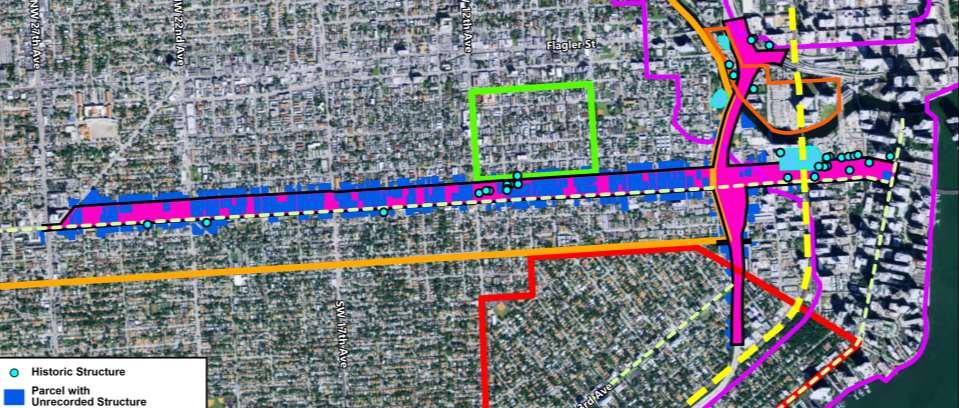
7 Study Area STATE HISTORIC HIGHWAYS SW 8th Street/Calle Ocho From the Palmetto Expressway (SW 74th Avenue) to Brickell Avenue Brickell Avenue From the Miami River south to SE 25th Road 7


8 Purpose and Need Safety - Improve Safety Crash data collected for 2011 to 2014 Crash data for 2015 will be collected Data analyzed yearly by: Crash Type Severity Lighting Conditions Surface Conditions Weather Conditions Day of the week & time 8

 in order to assess the efficiency of the transportation facility.")
9 Purpose and Need Traffic Operations - Improve traffic operations and multimodal level of service Substantial growth in transportation demand is anticipated through % to 1.9% annually. Note: Multimodal level of service (LOS) is a measure used to evaluate all modes of transportation (automobile, pedestrian, bicycle, and transit) in order to assess the efficiency of the transportation facility. A LOS A being the best and LOS F being the worst. 9


10 Purpose and Need Social Demands and Economic Development S - Improve access to urban central business districts Modal Interrelationships - Improve multimodal connectivity 10


11 EXISTING CONDITIONS ROADWAY SW 8th Street SW 7th Street 11

12 EXISTING CONDITIONS STRUCTURES I-95 southbound over Miami River I-95 northbound over Miami River I-95 northbound over SW 1st Avenue Pre-stressed AASHTO beams No loading restrictions High sufficiency rating 12

13 Previous Planning Study Feasibility Study- Completed June 2015 SR 90 from SR 5/Brickell Avenue to SR 9/SW 27th Avenue 13


14 Previous Feasibility Study PRELIMINARY BUILD SCENARIOS SW 7TH/SW 8TH STREETS 2 Lanes + Transit 2 Way SW 7 TH Street SW 7 TH Street SW 8 TH Street SW 8 TH Street Mixed Traffic Flow Direction Transit Flow Direction Mixed Traffic Flow Direction 14


15 Previous Feasibility Study PRELIMINARY BUILD SCENARIOS SW 7 TH /SW 8 TH STREETS 3 Lanes Reversed 3 Lane Alternative SW 7 TH Street SW 7 TH Street SW 8 TH Street SW 8 TH Street Mixed Traffic Flow Direction Mixed Traffic Flow Direction 15


16 Previous Feasibility Study PRELIMINARY BUILD SCENARIOS I-95 INTERCHANGE Alternative 1 Alternative 2 Alternative 3 Alternative 4 16


17 PD&E Study STUDY COMPONENTS Engineering Environmental Public Involvement 17


18 Engineering Complete Streets A street where the entire right-of-way is planned, designed and operated for all modes of transportation and all users regardless of age and ability. ADA accessible sidewalks with frequent and safe crossings Bicycle lanes Pedestrian lighting and accessible pedestrian signals Special bus lanes Comfortable and accessible public transportation stops Landscape curb extensions Roundabouts On-street parking 18


19 Engineering Safety Analysis Crash Analysis Highway Safety Manual Crash prediction procedures Analysis of Crash Types Calculation of Safety Ratio Identification of High Crash Locations Development of Mitigation Measures 19
20 Engineering Safety Analysis Crash Statistics SW 8 th Street SW 8th Street from SW 27th Avenue to Brickell Avenue Number of Crashes Year Year Total Crashes Mean Crashes Per Year CRASH TYPE Rear End % Head On % Angle % Left Turn % Right Turn % Sideswipe % Backed Into % Pedestrian % Bicycle % Fixed Object % Other Non Fixed Object % Collisions Parked Motor Vehicle % Non-Collisions % Others % Total Crashes % % 20
21 Engineering Safety Analysis Crash Statistics SW 7 th Street SW 7th Street from Brickell Avenue to SW 27th Avenue Number of Crashes Year Year Total Crashes Mean Crashes Per Year CRASH TYPE Rear End % Head On % Angle % Left Turn % Right Turn % Sideswipe % Backed Into % Pedestrian % Bicycle % Fixed Object % Other Non Fixed Object % Collisions Parked Motor Vehicle % Non-Collisions % Others % Total Crashes % % 21
22 Engineering Safety Analysis Total Crashes by Year SW 8 th Street
23 Engineering Safety Analysis Total Crashes by Year- SW 7 th Street
24 Engineering Traffic Analysis Traffic Data: Review of TMCs from the Feasibility Study Calculation of Traffic Growth Rates Collection of Recent Signal Timing Plans Travel Demand Forecasting Arterial Traffic Analysis (ARTPLAN and Synchro) Interchange Modification Report (IMR) (Synchro and VISSIM) 24
25 Engineering Traffic Analysis Travel Demand Forecasting Review and Development of Existing Year (2015) AADT, and AM and PM Peak Hour Volumes Subarea Model Design Year (2040) AADT, and AM/PM Peak Hour Volumes (Using SERPM 7 and TmTool/TURNS 5 tools) Interim Year (2030) AADT, and AM/PM Peak Hour Volumes (Interpolated from 2015 and 2040 Traffic Volumes) Opening Year (2020) AADT, and AM/PM Peak Hour Volumes (Interpolated from 2015 and 2040 Traffic Volumes) 25

26 Engineering Traffic Analysis Arterial Traffic Analysis (ARTPLAN) Multimodal Segment LOS Automobile Bicycle Pedestrian Transit Intersections Traffic Operations: Cycle Length, Thru g/c, and % Left/Right Turns Geometry: # Thru/Left Turn Lanes and Left Turn Storage Segments Traffic Factors: K, D, PHF, % H. Veh. Geometry: Length, # Thru Lanes, and Median Type Traffic Operations: AADT, Posted Speed, FFS Parking Activity Auto Lane Width Bike Pavement Condition Bike Lane/Side Path Configuration Sidewalk Configuration Bus Frequency Passenger Load Factor Amenities Bus Stop Type 26
 Traffic Data (peak hour volumes for existing and future conditions) Traffic Factors (PHF, % T) Automobile Segment and Intersection LOS")
27 Engineering Traffic Analysis Arterial Traffic Analysis (Synchro) Input Data: Detailed signal timing plans Roadway Geometry (# of lanes, left/right turn storage lanes) Traffic Data (peak hour volumes for existing and future conditions) Traffic Factors (PHF, % T) Automobile Segment and Intersection LOS 27

28 Engineering Traffic Analysis Interchange Modification Report (IMR) Synchro Analysis HCS Analysis VISSIM Analysis Peak Hour Analysis Determines the Performance of Signalized Intersections Peak Hour Analysis Determines the Performance of Freeway Segments Model Calibration Peak Period Analysis Determines the Performance of Freeway Segments Provides Additional Information on Unmet Demand, and Networkwide MOEs. 28


29 Environmental Analysis CULTURAL RESOURCES PHYSICAL EFFECTS Contamination, Air Quality, Noise NATURAL RESOURCES Water Quality and Wetlands 29
30 Environmental- Cultural Resources 30


31 Environmental- Cultural Resources CULTURAL RESOURCES Historic Resources within the Area of Potential Effect 33 previously recorded buildings One previously recorded historic District: Miami Roads Two potential historic districts: Riverside Heights/Little Havana Over 400 unrecorded historic buildings National Register eligible FEC railway Two state historic highways: Calle Ocho and Brickell Avenue 31

 City of Miami Jose Marti Park (including baseball fields - 315 SW 4th Street) Soccer Cage Miami (301 SW 8th Street)")
32 Environmental Potential Section 4(f) Resources Section 4(f) is part of federal law that requires special effort be made to protect publicly owned parks and recreational lands. Miami River (Biscayne Bay) Aquatic Preserve City of Miami Jose Marti Riverfront Park (315 SW 4th Street) City of Miami River Greenway Corridor (proposed trail network) City of Miami Jose Marti Park (including baseball fields SW 4th Street) Soccer Cage Miami (301 SW 8th Street) City of Miami Maximo Gomez Park (801 SW 15th Avenue) Metro-Dade Transit M-Path (Brickell Avenue/SW 8th Street) 32


33 Environmental No State Funds can be expended to Cut or remove trees Alter the physical dimensions Erect, demolish or alter the appearance of any structure Safety Improvements in Compliance Alter its location by either extension of: - Boundaries - The Name Maintenance and Repair in Compliance 33

34 Environmental - Physical Effects CONTAMINATION IMPACT ASSESSMENT Potential contamination sites: Gas stations, dry cleaners, light industry Typical for dense complex urban environment Main area of concern: I-95 Interchange Subsurface construction may impact soil and/or groundwater Evaluate underground utility work, stormwater pond locations, ROW acquisition AIR QUALITY Air Quality Technical Memorandum NOISE Noise Study Report 34
 WETLANDS AND ESSENTIAL FISH HABITAT No direct impacts expected WILDLIFE AND HABITAT Assessment of")
35 Environmental Natural Resources WATER QUALITY Biscayne Bay is a sole source aquifer SPECIAL DESIGNATIONS Biscayne Bay Aquatic Preserve; Outstanding Florida Waters (Note: Includes Miami River in vicinity of project ETDM Moderate Degree of Effect, due primarily to proximity to Biscayne Bay) WETLANDS AND ESSENTIAL FISH HABITAT No direct impacts expected WILDLIFE AND HABITAT Assessment of wildlife and habitat will be conducted 35


36 Public Involvement MEETINGS Elected Officials/Agencies/Public Kick-off Meeting Project Advisory Group (PAG) Alternatives Public Workshop Public Hearing PROJECT WEBSITE 36

37 Project Schedule 37
38 Questions / Comments Bao-Ying Wang, P.E. Project Manager Consultant Management Office Florida Department of Transportation District Six 1000 NW 111 Avenue, Room 6251 Miami, Florida Phone: BaoYing.Wang@dot.state.fl.us Vilma Croft, P.E. Project Manager HNTB Corporation Phone: VCroft@hntb.com 38
Project Development & Environment (PD&E) Study JUNE 22, SR 90 (SW 8th Street and SW 7th Street) SW 8 th Street/SW 7 th Street PD&E Study 1
 Study JUNE 22, SR 90 (SW 8th Street and SW 7th Street) SW 8 th Street/SW 7 th Street PD&E Study 1") Financial Management Number: 432639-6-22-01 Federal Aid Project Number: 0202-054-P Efficient Transportation Decision Making Number: 14230 Project Development & Environment (PD&E) tudy R 90 (W 8th treet
Financial Management Number: 432639-6-22-01 Federal Aid Project Number: 0202-054-P Efficient Transportation Decision Making Number: 14230 Project Development & Environment (PD&E) tudy R 90 (W 8th treet
FM #: ETDM #: 11241
 SR 826/Palmetto Expressway PD&E Study From SR 93/I 75 to the Golden Glades Interchange FM #: 418423 1 22 01 ETDM #: 11241 Agency/ Kick Off Meeting October 27, 2011 2 Location Map From SR 93/I 75 to Golden
City of Gainesville Transportation/Roadway Needs PROJECT SUMMARY
 A1 Roadway Resurfacing $23,846,000 TYPE: Preservation of existing system Roadway resurfacing A2 Signal Replacement $6,000,000 TYPE: Preservation of existing system Replace traffic signals. B1 W 6th St
MDX SR 836/DOLPHIN EXPRESSWAY SOUTHWEST EXTENSION Project Development and Environment PD&E Study Miami-Dade County, Florida
 MDX SR 836/DOLPHIN EXPRESSWAY SOUTHWEST EXTENSION Project Development and Environment PD&E Study Miami-Dade County, Florida Citizens Advisory Committee Meeting March 13, 2018 ETDM NUMBER: 11482 MDX WORK
Project Development & Environment (PD&E) Study Public Hearing January 12 th, 2006
 Study Public Hearing January 12 th, 2006") Project Development & Environment (PD&E) Study Public Hearing January 12 th, 2006 Public Hearing Regulations Chapter 23 of United States Code 128 Title 40 of the Code of Federal Regulations Parts 1500
Project Development & Environment (PD&E) Study Public Hearing January 12 th, 2006 Public Hearing Regulations Chapter 23 of United States Code 128 Title 40 of the Code of Federal Regulations Parts 1500
Waterford Lakes Small Area Study
 Waterford Lakes Small Area Study Existing Traffic Conditions PREPARED FOR: ORANGE COUNTY PUBLIC WORKS DEPARTMENT TRAFFIC ENGINEERING DIVISION ORLANDO, FLORIDA PREPARED WITH: INWOOD CONSULTING ENGINEERS
Planning Study SR 976. Project Advisory Team Meeting May 24, 2017
 ` SR 976 BIRD ROAD/SW 40TH STREET FROM SR 821/HEFT TO SR 5/US-1 Miami-Dade County, Florida FPID No.: 434845-4-22-01 Planning Study Project Advisory Team Meeting May 24, 2017 1 Agenda Introductions Project
TRAFFIC IMPACT ANALYSIS
 TRAFFIC IMPACT ANALYSIS FOR THE CHAMPAIGN UNIT#4 SCHOOL DISTRICT PROPOSED HIGH SCHOOL (SPALDING PARK SITE) IN THE CITY OF CHAMPAIGN Final Report Champaign Urbana Urbanized Area Transportation Study 6/24/2014
Mark Malone, P.E. SD DOT
 Mark Malone, P.E. SD DOT SD10 Grading & Surfacing From 8 th Ave W to 8 th Ave E 1 mile plus transition lengths Complete Urban Reconstruction Grading, C&G, Storm Sewer, Sidewalk, Concrete Surfacing Railroad
APPENDIX G: INTERSECTION NEEDS AT OKEECHOBEE BOULEVARD
 APPENDIX G: INTERSECTION NEEDS AT OKEECHOBEE BOULEVARD INTERSECTION NEEDS AT SR 7 and OKEECHOBEE BOULEVARD SR 7 Extension Project Development and Environment (PD&E) Study From Okeechobee Boulevard (SR
US 1 Express Lanes Public Kick-Off Meeting
 US 1 Express Lanes Project Development & Environment (PD&E) Study Public Kick-Off Meeting September 7 & 8, 2011 Miami Dade County, Florida 1 Presentation Agenda Introduction to MDX Background to PD&E studies
Community Advisory Committee
 Community Advisory Committee Meeting #1 November 19, 2014 Presentation Team Matt Fulda, Greater Bridgeport Regional Council Chris Granatini, P.E., Tighe & Bond Craig Yannes, P.E., PE PTOE, Tighe & Bond
Financial Project ID No(s).: and ETDM No(s).: and 14181
.: and ETDM No(s).: and 14181") Palm Beach Metropolitan Planning Organization (MPO) Presentation I-95 at Boynton Beach Boulevard Interchange and I-95 at Gateway Boulevard Interchange Project Development and Environment Study Palm Beach
Palm Beach Metropolitan Planning Organization (MPO) Presentation I-95 at Boynton Beach Boulevard Interchange and I-95 at Gateway Boulevard Interchange Project Development and Environment Study Palm Beach
Complete Street Analysis of a Road Diet: Orange Grove Boulevard, Pasadena, CA
 Complete Street Analysis of a Road Diet: Orange Grove Boulevard, Pasadena, CA Aaron Elias, Bill Cisco Abstract As part of evaluating the feasibility of a road diet on Orange Grove Boulevard in Pasadena,
SR 9/I-95 Interchange at 45 th Street PD&E Study Palm Beach County, Florida FPID No.: FAP No.: ETDM No.
 SR 9/I-95 Interchange at PD&E Study Palm Beach County, Florida FPID No.: 436519-1-22-01 FAP No.: 0951-682-1 ETDM No.: 14225 Palm Beach County MPO October 19, 2017 SR 9/I-95 Interchange at PD&E Study Presentation
Project Advisory Group Meeting No. 2
 State Road (SR) 90/SW 8th Street and SW 7th Street Project Development and Environment (PD&E) Study Financial Project ID No.: 432639-6-22-01 Efficient Transportation Decision Making (ETDM) No.: 14230 Project
5.0 Roadway System Plan
 Southwest Boise Transportation Study Page 16 5.0 Roadway System Plan The Roadway System Plan outlines roadway improvements in the Initial Study Area. It forecasts future deficiencies on the arterial system,
Town of Bethlehem. Planning Assessment. Bethlehem Town Board
 Town of Bethlehem US 9W Corridor Transportation Planning Assessment Presented e to: Bethlehem Town Board June 2009 Overview Study Background Route 9W Corridor Conditions and Improvements Selkirk Bypass
Downtown Naples Mobility and Connectivity Study. Naples City Council Presentation January 2017
 Downtown Naples Mobility and Connectivity Study Naples City Council Presentation January 2017 Agenda 1. Introduction 2. Scope Review 3. Project Schedule 4. Existing Conditions 5. Public Charrette 6. Mobility
Los Altos Hills Town Council - June 18, 2015 Palo Alto City Council June 22, AGENDA ITEM #2.B Presentation
 Los Altos Hills Town Council - June 18, 2015 Palo Alto City Council June 22, 2015 AGENDA ITEM #2.B Presentation Previous Presentations Los Altos Hills Town Council in May 2014 and February 2015 Palo Alto
4. ENVIRONMENTAL IMPACT ANALYSIS 9. TRANSPORTATION AND TRAFFIC
 4. ENVIRONMENTAL IMPACT ANALYSIS 9. TRANSPORTATION AND TRAFFIC 4.9.1 INTRODUCTION The following section addresses the Proposed Project s impact on transportation and traffic based on the Traffic Study
Chapter 4 Traffic Analysis
 Chapter 4 Traffic Analysis PURPOSE The traffic analysis component of the K-68 Corridor Management Plan incorporates information on the existing transportation network, such as traffic volumes and intersection
Clackamas County Comprehensive Plan
 ROADWAYS The County s road system permits the movement of goods and people between communities and regions, using any of a variety of modes of travel. Roads provide access to virtually all property. They
SR 826/PALMETTO EXPRESSWAY EXPRESS LANES PD&E STUDY From US 1/SR 5/Dixie Highway to SR 836/Dolphin Expressway FPID No.: ETDM No.
 SR 826/PALMETTO EXPRESSWAY EXPRESS LANES PD&E STUDY From US 1/SR 5/Dixie Highway to SR 836/Dolphin Expressway FPID No.: 432639-1-22-02 ETDM No.: 14308 Newsletter 3 - March 2019 Incluye versión en español
Basalt Creek Transportation Refinement Plan Recommendations
 Basalt Creek Transportation Refinement Plan Recommendations Introduction The Basalt Creek transportation planning effort analyzed future transportation conditions and evaluated alternative strategies for
Multimodal Analysis in the 2010 Highway Capacity Manual
 Multimodal Analysis in the 2010 Highway Capacity Manual It s not just cars anymore! Jamie Parks, AICP HCAT Conference May 9-10, 2011 Multimodal LOS in the 2010 HCM History and background Overview of methods
CITY OF COCOA BEACH 2025 COMPREHENSIVE PLAN. Section VIII Mobility Element Goals, Objectives, and Policies
 CITY OF COCOA BEACH 2025 COMPREHENSIVE PLAN Section VIII Mobility Element Goals, Objectives, and Policies Adopted August 6, 2015 by Ordinance No. 1591 VIII MOBILITY ELEMENT Table of Contents Page Number
Performance Criteria for 2035 Long Range Transportation Plan
 Minimizing Impacts on Natural, Historic, Cultural or Archeological Resources 2035 LRTP Weighting Factor: 7% Objective 1.1: Use appropriate planning and design criteria to protect and enhance the built
Roundabout Feasibility Memorandum
 Roundabout Feasibility Memorandum To From Gwen Pipkin Bill Howell Date June 18, 2013 Subject Roundabout Feasibility Study SR 29 PD&E Study From Oil Well Road to SR 82 Collier County, FL FPID 417540-1-22-01
WELCOME. Stakeholder Involvement Group Meeting #2 Round Lake Public Works October 24, 2018
 WELCOME Stakeholder Involvement Group Meeting #2 Round Lake Public Works October 24, 2018 MEETING AGENDA 1. Welcome and Introductions 2. Study Progress Update 3. Problem Statement 4. Technical Analysis
DRAFT. Corridor study. Honeysuckle Road. October Prepared for the City of Dothan, AL. Prepared by Gresham, Smith and Partners
 DRAFT Corridor study Honeysuckle Road October 2017 Prepared for the City of Dothan, AL Prepared by TABLE OF CONTENTS SECTION I... 1 STUDY SUMMARY... 1 INTRODUCTION... 1 CONCLUSIONS... 5 SECTION II... 7
Figure 1: Vicinity Map of the Study Area
 ARIZONA TEXAS NEW MEXICO OKLAHOMA May 5, 2016 Mr. Anthony Beach, P.E. BSP Engineers 4800 Lakewood Drive, Suite 4 Waco, Texas 76710 Re: Intersection and Access Analysis along Business 190 in Copperas Cove
The current document is revised based on the comments received on:
 General Overview 1 Introduction Over the last several years, the Waterford Lakes area has experienced increased congestion due to a substantial increase in residential and commercial development. The current
Pine Hills Road Pedestrian/Bicycle Safety Study Board of County Commissioners Work Session
 Pine Hills Road Pedestrian/Bicycle Safety Study Board of County Commissioners Work Session February 20, 2018 Meeting Agenda Study Overview Existing Conditions Access Management Potential Gateway Features
J-Turn An Intersection Safety Improvement Purdue Road School 2016 Tuesday, March 8, 2016 Brian Malone, INDOT & Josh Cook, HNTB
 J-Turn An Intersection Safety Improvement Purdue Road School 2016 Tuesday, March 8, 2016 Brian Malone, INDOT & Josh Cook, HNTB US 231 and SR 62 and SR 68 US 231 and SR 62 Intersection Traffic Data Traffic
Reams Road RCA Study. Board of County Commissioners Public Hearing
 Reams Road RCA Study Board of County Commissioners Public Hearing April 24, 2018 Presentation Overview Study Overview Existing Conditions Development of Alternatives Preferred Alternative Public Involvement
Dr. M.L. King, Jr. Street North Complete Streets Resurfacing Opportunities HOUSING, LAND USE, AND TRANSPORTATION COMMITTEE MARCH 22, 2018
 Dr. M.L. King, Jr. Street North Complete Streets Resurfacing Opportunities HOUSING, LAND USE, AND TRANSPORTATION COMMITTEE MARCH 22, 2018 What s Happening The City plans to mill and resurface Dr. M.L.
Waterford Lakes Small Area Study
 Over the last several years, the Waterford Lakes area has experienced increased congestion due to a substantial increase in residential and commercial development. The current Existing and Future Conditions
Figure 1: East West Connector Alignment Alternatives Concept Drawing
 Page 2 of 9 Figure 1: East West Connector Alignment Alternatives Concept Drawing The Montebello Drive extension will run north south and connect Wilsonville Road to the Boones Ferry Road to Brown Road
CSAH 101 Preliminary Design
 CSAH 101 Preliminary Design Public Open House No. 2 January 29, 2013 CSAH 62 to Hutchins Drive Welcome / Introductions Hennepin County Craig Twinem, Transportation Maury Hooper, Transportation Nick Peterson,
Welcome to the Open House
 Leslie Street Between 19 th Avenue and Stouffville Road Addendum to Class Environmental Assessment Study Welcome to the Open House Please sign in at the front desk. March 28, 2017 Richmond Green Sports
5. RUNNINGWAY GUIDELINES
 5. RUNNINGWAY GUIDELINES These guidelines should be considered collectively when making runningway decisions. A runningway is the linear component of the transit system that forms the right-of-way reserved
AMATS Complete Streets Policy
 AMATS Complete Streets Policy Table of Contents: Section 1. Definition of Complete Streets Section 2. Principles of Complete Streets Section 3. Complete Streets Policy Section 4. Consistency Section 5.
Design Traffic Technical Memorandum
 State Road 7 Extension PD&E Study Design Traffic Technical Memorandum Palm Beach County, FL October 2010 State Road 7 Extension PD&E Study Design Traffic Technical Memorandum Palm Beach County, FL Prepared
Project Report. South Kirkwood Road Traffic Study. Meadows Place, TX October 9, 2015
 Meadows Place, TX October 9, 2015 Contents 1 Introduction... 1 2 Data Collection... 1 3 Existing Roadway Network... 2 4 Traffic Volume Development... 2 5 Warrant Analysis... 3 6 Traffic Control Alternative
Route 7 Corridor Study
 Route 7 Corridor Study Executive Summary Study Area The following report analyzes a segment of the Virginia State Route 7 corridor. The corridor study area, spanning over 5 miles in length, is a multi
PROJECT OBJECTIVES. Improve vehicle capacity for the intersection. Improve pedestrian and bicycle access
 COMMUNITY MEETING Project Update March 15, 2010 Purcellville, Virginia OVERVIEW Project need / objectives Project recap Design elements Proposed improvements Summary of project benefits / next steps PROJECT
REGIONAL BICYCLE AND PEDESTRIAN DESIGN GUIDELINES
 REGIONAL BICYCLE AND PEDESTRIAN DESIGN GUIDELINES November 16, 2011 Deb Humphreys North Central Texas Council of Governments Bicycle and Pedestrian Advisory Committee Snapshot of the Guide 1. Introduction
CITY OF OAKLAND. 27th Street Bikeway Feasibility and Design. Final Report (v3) March 23, Kimley-Horn and Associates, Inc.
 March 23, Kimley-Horn and Associates, Inc.") CITY OF OAKLAND 27th Street Bikeway Feasibility and Design Final Report (v3) March 23, 2007 PREPARED BY: Kimley-Horn and Associates, Inc. Table of Contents 1. Introduction 3 2. 27 th Street/Bay Place Corridor
CITY OF OAKLAND 27th Street Bikeway Feasibility and Design Final Report (v3) March 23, 2007 PREPARED BY: Kimley-Horn and Associates, Inc. Table of Contents 1. Introduction 3 2. 27 th Street/Bay Place Corridor
Lyons Avenue/Dockweiler Road Extension Project Draft Environmental Impact Report. Appendix I Traffic Impact Study
 Lyons Avenue/Dockweiler Road Extension Project Draft Environmental Impact Report Appendix I Traffic Impact Study Street 0 80-1947 500.4501 RITA ld Court 0 91355-1096 400.7401 LA n Avenue 0 590-3745 300-9301
New Measure A Expenditure Categories DEFINITIONS OF ELIGIBLE EXPENDITURES Adopted March 8, 2007
 New Measure A Expenditure Categories DEFINITIONS OF ELIGIBLE EXPENDITURES Adopted March 8, 2007 City Street and County Road Maintenance Program The preservation and keeping of public street and road rights-of-way
US 41 COMPLETE STREETS CORRIDOR PLANNING STUDY from University Parkway to Whitfield Avenue
 41 US 41 COMPLETE STREETS CORRIDOR PLANNING STUDY from University Parkway to Whitfield Avenue EXECUTIVE SUMMARY DRAFT FEBRUARY 2019 Project Overview The US 41 Complete Streets Corridor Planning Study,
DOWNTOWN MIAMI PEDESTRIAN PRIORITY ZONE
 DOWNTOWN MIAMI PEDESTRIAN PRIORITY ZONE AUGUST 6, 2013 DOWNTOWN MIAMI BY THE NUMBERS more than 200,000 people live, work, and play here every day is home to more than 1,000 events each year hosts more
Alternatives Public Workshop
 US 1 Express Lanes Project Development & Environment (PD&E) Study Alternatives Public Workshop August 2013 1 Today s Agenda Project Background and Overview Tier 1 Alternatives Development Tier 2 Decision-Making
TRANSPORTATION & MOBILITY VISIONING MEETING. August 23 24, 2017
 TRANSPORTATION & MOBILITY VISIONING MEETING August 23 24, 2017 Project Team 1999 South Lakefront Framework Plan In 1999, the Chicago Park District authorized framework plans for three historic parks: Jackson,
Atwood Avenue Fair Oaks Avenue Cottage Grove Road
 Atwood Avenue Fair Oaks Avenue Cottage Grove Road Agenda Purpose Review project scope & goals Present design alternatives Gather feedback Answer Questions Format Open House Presentation Q&A Open House
Regional Transportation Needs Within Southeastern Wisconsin
 Regional Transportation Needs Within Southeastern Wisconsin #118274 May 24, 2006 1 Introduction The Southeastern Wisconsin Regional Planning Commission (SEWRPC) is the official areawide planning agency
Emerging Methods for Evaluating Transportation Systems Multimodal LOS and Highway Safety Manual
 Emerging Methods for Evaluating Transportation Systems Multimodal LOS and Highway Safety Manual November 8, 2012 Lake Merritt Tower in Oakland Transportation Education Series 1 Presenters Mark Bowman,
Preliminary Transportation Analysis
 Preliminary Transportation Analysis Goals of a Robust, Multimodal Transportation Network Safe Accessible/Connected Efficient Comfortable Context-Sensitive Motor Vehicle: Continue to analyze the data to
ACTIVE TRANSPORTATION
 ACTIVE TRANSPORTATION Mobility 2040 Supported Goals Improve the availability of transportation options for people and goods. Support travel efficiency measures and system enhancements targeted at congestion
Multimodal Through Corridors and Placemaking Corridors
 68 Multimodal Through Corridors and Placemaking Corridors Corridors have different functions in a region. Some corridors are used to get smoothly and rapidly through a region or to get quickly to major
Item to be Addressed Checklist Consideration YES NO N/A Required Description Complete Streets Guidelines
 Passaic County Complete Streets Checklist - Concept Development Project Name Item to be Addressed Checklist Consideration YES NO N/A Required Description Complete Streets Guidelines Existing Plans Have
City of Seattle Edward B. Murray, Mayor
 City of Seattle Edward B. Murray, Mayor Department of Transportation Scott Kubly, Director Eastlake Community Council 117 E Louisa St. #1 Seattle, WA 98102-3278 January 28, 2016 RE: Roosevelt to Downtown
US287 Asset Inventory Fort Collins. Figure 5-1 Fort Collins Bridges and Traffic Signals
 Chapter 5: City of Fort Collins US287 through Fort Collins is known as College Avenue, runs for approximately 9.25 miles, and bisects the City north to south. Within the City, US287 is a principal arterial.
Bellevue Transportation: Challenges, Opportunities and Priorities Bellevue Downtown Association September 20, 2018
 Bellevue Transportation: Challenges, Opportunities and Priorities Bellevue Downtown Association September 20, 2018 Dave Berg Transportation Director City of Bellevue Traffic, traffic and more traffic!
DEPARTMENT OF ENVIRONMENTAL SERVICES. North Harrison Street (Lee Highway to Little Falls Road) Comparative Analysis. Prepared for:
 Comparative Analysis. Prepared for:") DEPARTMENT OF ENVIRONMENTAL SERVICES North Harrison Street (Lee Highway to Little Falls Road) Comparative Analysis Prepared for: Arlington County Department of Environmental Services 2100 Clarendon Boulevard,
DEPARTMENT OF ENVIRONMENTAL SERVICES North Harrison Street (Lee Highway to Little Falls Road) Comparative Analysis Prepared for: Arlington County Department of Environmental Services 2100 Clarendon Boulevard,
David DiPierro, John Amberson. Steering Committee Meeting #4 Overview
 IBI GROUP 18401 Von Karman Avenue Suite 110 Irvine CA 92612 USA tel 949 833 5588 fax 949 833 5511 ibigroup.com Memorandum To/Attention Steering Committee Members Date February 17, 2016 From IBI Group Project
RZC Appendix 8A Marymoor Subarea Street Requirements
 RZC Appendix 8A Marymoor Subarea Street Requirements For additional design details for Marymoor Subarea infrastructure, refer to the 2017 Marymoor Subarea Infrastructure Planning Report. STREET REQUIREMENTS
City of Novi Non-Motorized Master Plan 2011 Executive Summary
 City of Novi Non-Motorized Master Plan 2011 Executive Summary Prepared by: February 28, 2011 Why Plan? Encouraging healthy, active lifestyles through pathway and sidewalk connectivity has been a focus
General Plan Circulation Element Update Scoping Meeting April 16, 2014 Santa Ana Senior Center, 424 W. 3rd Street, Santa Ana, CA 92701
 General Plan Circulation Element Update Scoping Meeting April 16, 2014 Santa Ana Senior Center, 424 W. 3rd Street, Santa Ana, CA 92701 Meeting Agenda 1. Purpose of Scoping Meeting 2. Project Overview 3.
List of Exhibits...ii
 One Brickell Traffic Study TABLE OF CONTENTS List of Exhibits...ii EXECUTIVE SUMMARY...1 1. INTRODUCTION...2 1.1 Study Area...2 1.2 Study Objective...5 2. EXISTING TRAFFIC CONDITIONS...6 2.1 Data Collection...6
INDUSTRIAL BUILDING 1660 COMSTOCK ROAD CITY OF OTTAWA TRANSPORTATION OVERVIEW. Prepared for:
 INDUSTRIAL BUILDING 1660 COMSTOCK ROAD CITY OF OTTAWA TRANSPORTATION OVERVIEW Prepared for: Simluc Contractors Limited 2550 Blackwell Street, Ottawa K1B 5R1 October 18, 2013 113-584 Overview_1.doc D. J.
TRAFFIC IMPACT STUDY CRITERIA
 Chapter 6 - TRAFFIC IMPACT STUDY CRITERIA 6.1 GENERAL PROVISIONS 6.1.1. Purpose: The purpose of this document is to outline a standard format for preparing a traffic impact study in the City of Steamboat
MCTC 2018 RTP SCS and Madera County RIFP Multi-Modal Project Eval Criteria GV13.xlsx
 MCTC 8 RTP SCS and Madera County RIFP Multi-Modal Project Eval Criteria GV.xlsx Madera County Transportation Commission Regional Transportation Plan / Sustainable Communities Strategy Multi-Modal Project
University Hill Transportation Study Technical Memorandum Alternatives Modeling and Analysis May 2007
 Technical Memorandum May 2007 Syracuse Metropolitan Transportation Council Edwards and Kelcey with Wallace Roberts and Todd Alta Planning and Design CONTENTS SECTION ONE- INTRODUCTION...1 SECTION TWO-
Simulating Street-Running LRT Terminus Station Options in Dense Urban Environments Shaumik Pal, Rajat Parashar and Michael Meyer
 Simulating Street-Running LRT Terminus Station Options in Dense Urban Environments Shaumik Pal, Rajat Parashar and Michael Meyer Abstract The Exposition Corridor transit project is a light rail project
Virginia Street Bus RAPID Transit Extension Project. Environmental Assessment (EA) Presentation Public Hearing June 22, 2017
 Presentation Public Hearing June 22, 2017") Virginia Street Bus RAPID Transit Extension Project Environmental Assessment (EA) Presentation Public Hearing June 22, 2017 Presentation to RTC July 17, 2015 Presentation Overview Project Timeline Environmental
Virginia Street Bus RAPID Transit Extension Project Environmental Assessment (EA) Presentation Public Hearing June 22, 2017 Presentation to RTC July 17, 2015 Presentation Overview Project Timeline Environmental
In station areas, new pedestrian links can increase network connectivity and provide direct access to stations.
 The Last Mile Planning for Pedestrians Planning around stations will put pedestrians first. Making walking to stations safe and easy is important; walking will be a part of every rapid transit Accessible
Florida Department of Transportation District Four. I-95 at 6 th Avenue Interchange Improvements FDOT PM - Fernando Morales, PE
 1 Florida Department of Transportation District Four I-95 at 6 th Avenue Interchange Improvements FDOT PM - Fernando Morales, PE Presentation Outline Overview of Planning and Programming I-95 Interchange
Small Area Study U.S. Route 220 and VA Route 615 Intersection. Bath County, Virginia
 Small Area Study U.S. Route 220 and VA Route 615 Intersection Bath County, Virginia Prepared by the Central Shenandoah Planning District Commission Final Report February 2018 Table of Contents 1. INTRODUCTION...
Presentation Outline. PD&E Study Process Project Overview Proposed Alternatives & Evaluation Schedule Contact Information
 Volusia Transportation Planning Organization CAC / TCC Project Update Tuesday, May 21, 2013 1 Presentation Outline PD&E Study Process Project Overview Proposed Alternatives & Evaluation Schedule Contact
Project Application. Project Location: Salem Drive (Federal Route 1101)
") Project Application General Information Municipality/Lead Agency: Hoffman Estates 1. Contact Person: Michael Hankey 2. Contact Phone: 847 252-5801 3. Contact Email: mike.hankey@hoffmanestates.org Project
Project Application General Information Municipality/Lead Agency: Hoffman Estates 1. Contact Person: Michael Hankey 2. Contact Phone: 847 252-5801 3. Contact Email: mike.hankey@hoffmanestates.org Project
City of Memphis On-Street Parking Modification Guidelines
 City of Memphis Effective Date: December 1, 2013 Bicycle/Pedestrian Program 125 N. Main Street Memphis, TN 38103 (901) 576-6710 www.bikepedmemphis.com City of Memphis Executive Summary It is current practice
Beach Cities Living Streets Design Manual and Aviation Boulevard Multimodal Corridor Plan
 Beach Cities Living Streets Design Manual and Aviation Boulevard Multimodal Corridor Plan AGENDA 1 Introductions & Project Scope 2 Public Outreach Recap 3 Living Streets Design Manual 4 Aviation Boulevard
Safety Emphasis Areas & Safety Project Development Florida Department of Transportation District Seven Tampa Bay
 Safety Emphasis Areas & Safety Project Development Florida Department of Transportation District Seven Tampa Bay Stephen L. Benson, AICP, CNU-A FDOT District Seven Safety Office Presentation Overview Safety
Application of a Complete Street
 Application of a Complete Street Southbend to Prima Vista Update May 14, 2018 Meeting Agenda Perspective and History Public input received Typical sections being considered Presentation of the 2-lane master
SECTION 1 - TRAFFIC PLANNING
 SECTION 1 - TRAFFIC PLANNING 1.1 TRAFFIC OPERATIONS 1.1.1 Roadway Functional Classification The Multnomah County Comprehensive Framework Plan s Policy 34: Trafficways and the Functional Classification
Balancing Operation & Safety for Motorized and Non-Motorized Traffic
 Balancing Operation & Safety for Motorized and Non-Motorized Traffic Brian Willham, PE, PTOE Iowa Director - MOVITE June 30, 2014 Learning Objectives: When & Why should we measure the performance of complete
Most Important Part of any Plan
 Most Important Part of any Plan Objectives must be evaluated to determine if they have been achieved Achievement of Objectives: 10 of 13 Objectives Achieved 1 not achieved 2 not due yet Transportation
Omaha s Complete Streets Policy
 Omaha s Complete Streets Policy (Adopted August 2015) VISION To create great places and enhance our quality of life, the City of Omaha will provide safe, accessible streets for all users. Complete Streets
Moving Towards Complete Streets MMLOS Applications
 Moving Towards Complete Streets MMLOS Applications Transportation Education Series May 18 th, 2012 It s not just for cars! Presentation Overview The Complete Streets Movement What is Multi-Modal Level
1609 E. FRANKLIN STREET HOTEL TRAFFIC IMPACT STUDY EXECUTIVE SUMMARY
 1609 E. FRANKLIN STREET HOTEL TRAFFIC IMPACT STUDY EXECUTIVE SUMMARY Prepared for: The Town of Chapel Hill Public Works Department Traffic Engineering Division Prepared by: HNTB North Carolina, PC 343
MEDICAL/OFFICE BUILDING 1637 BANK STREET OTTAWA, ONTARIO TRANSPORTATION OVERVIEW. Prepared for:
 MEDICAL/OFFICE BUILDING 1637 BANK STREET OTTAWA, ONTARIO TRANSPORTATION OVERVIEW Prepared for: 2434984 Ontario Inc. 13-5510 Canotek Road Ottawa, Ontario K1J 9J5 June 4, 2015 115-613 Report_2.doc D. J.
What Is a Complete Street?
 Session 5 Charleen Zimmer, AICP, Zan Associates May 5-7, 2010 What Is a Complete Street? May 2010 5-1 Not a Complete Street More of a Complete Street May 2010 5-2 Benefits of Complete Streets Safety for
HSM PREDICTIVE METHODS IN PRELIMINARY ENGINEERING
 HSM PREDICTIVE METHODS IN PRELIMINARY ENGINEERING 2017 ILLINOIS THE CONFERENCE Filiberto Sotelo & Steven Schilke, P.E. OUTLINE Safety & Transportation Management Process What is HSM? Illinois HSM Predictive
TRANSPORTATION NEEDS ASSESSMENT
 TRANSPORTATION NEEDS ASSESSMENT A travel demand analysis was carried out to determine the operational issues and the potential benefit that adding traffic capacity would have on the road network. All the
Overview. Illinois Bike Summit IDOT Complete Streets Policy Presentation. What is a Complete Street? And why build them? And why build them?
 Overview Illinois Bike Summit IDOT Complete Streets Policy Presentation Aren Kriks, P.E. District One Bicycle Coordinator and Bureau of Programming Project Engineer History of Complete Streets IDOT Policy
Living Streets Policy
 Living Streets Policy Introduction Living streets balance the needs of motorists, bicyclists, pedestrians and transit riders in ways that promote safety and convenience, enhance community identity, create
This chapter describes the proposed circulation system and transportation alternatives associated with
 5.0 Circulation 5.1 OVERVIEW This chapter describes the proposed circulation system and transportation alternatives associated with West Landing, and summarize the information contained in the Existing
Phone: Fax: Project Reference No. (to be filled out by MassHighway):
:") Massachusetts Highway Department District 3 Project Need Form (PNF) This form is intended to provide preliminary information about the proposed project. It is not expected that all information that is
Massachusetts Highway Department District 3 Project Need Form (PNF) This form is intended to provide preliminary information about the proposed project. It is not expected that all information that is