Project Introduction. area. The Diamond Springs and El Dorado Area Mobility and Livable Community Plan will also consider
|
|
|
- Shanon Daniel
- 6 years ago
- Views:
Transcription


1 April 3, :00 8:00 p.m. Union Mine High School Library 6530 Koki Lane, El Dorado Project Introduction The Diamond Springs and El Dorado Area Mobility and Livable Community Plan will explore improvements to the transportation system, including SR 49, which will enhance interregional and regional traffic safety and operations. The study will consider the El Dorado County General Plan, including land uses identified in the plan, and other relevant planning documents to ensure that potential improvements to the transportation system are consistent with those plans and are acceptable, safe, and in accordance with Caltrans and other applicable standards and are compatible with planned zoning and land uses in the project area. The Diamond Springs and El Dorado Area Mobility and Livable Community Plan will also consider how potential new improvements to the transportation system, including providing alternate routes and improved access to multi modal transportation options such as bicycle and pedestrian facilities and transit, may effect jobs, project area demographics, population growth and distribution projections, as well as current and future traffic demand and transportation impacts. Workshop #1 Purpose The Plan s focus is to improve traffic circulation and increase mobility for the communities of Diamond Springs and El Dorado. The purpose of the workshop was to provide an overview of the project and facilitate participation of local residents in identifying community values, preferred options for street treatments, and confirming highly used routes for automobiles, bicycles, and pedestrians. Publicity & Noticing Community workshop notification flyers were sent via to local jurisdictions, interested agencies, vicinity organizations, and interested individuals. Over seventy workshop notification flyers were ed or faxed to business and property owners in Diamond Springs and El Dorado. The community workshop flyer was posted on the EDCTC website ( and Facebook page. A public meeting notice was placed in the Mountain Democrat and published on March 29. Page 1 of 6


2 Press releases were sent via to the following publications: KCRA NBC Channel 3 KOVR CBS Channel 13 KXTV ABC Channel 10 El Dorado Hills Telegraph The Mountain Democrat The Clipper Village Life Newspapers Sacramento Business Journal The Sacramento Bee Community Workshop Format Over thirty community members attended the workshop which was organized as an open house with a series of information stations. Attendees were encouraged to visit the stations where project team members were available to answer questions. Each station included an opportunity to provide input on different areas of the plan, in addition attendees were given a feedback form to provide their thoughts and ideas. At 6:30 p.m. County Supervisor Brian Veerkamp welcomed attendees and spoke about the importance of the Diamond Springs and El Dorado Area Mobility and Livable Community Plan. This was followed by a brief overview of the project by EDCTC staff and the project team. Information Stations included: Welcome Table o As attendees entered the workshop format was explained and they were provided with a feedback form. Station #1: Community Values o Large posters depicted community values identified by Stakeholder Advisory Committee (SAC) members. Values depicted what the community would like to create, preserve, and avoid with the plan. Page 2 of 6


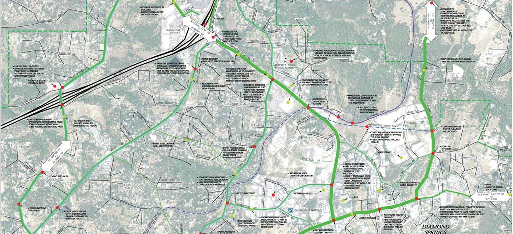
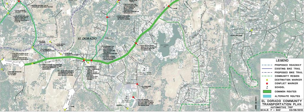
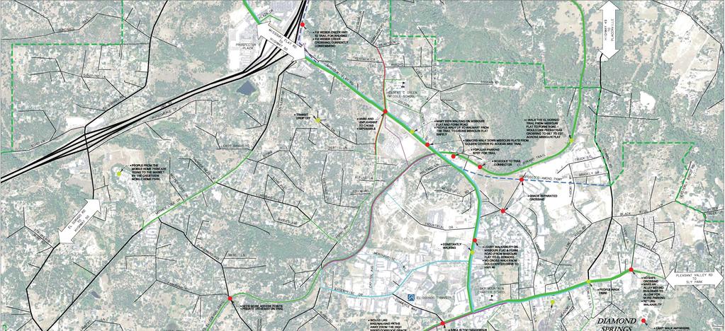
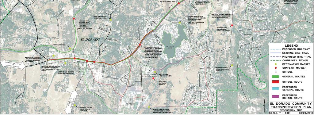
3 Attendees were asked to prioritize the values and add comments using post it notes. Station #2: Complete Streets Tools o Large posters depicted photo examples of complete street treatments. Attendees were asked to place green dots on treatments that they liked and thought appropriate for the community or red dots on treatments they did not like. Station #3: Transportation Network Automobile o Using markers and a large map of the project area, attendees were asked to identify highly used automobile routes, alternate routes, and barriers or challenges along the routes. Attendees were encouraged to add comments or questions to the maps via post it notes. Station #4: Transportation Network Bicycle o Using markers and a large map of the project area, attendees were asked to identify highly used bicycle routes, alternate routes, and barriers or challenges along the routes. Attendees were encouraged to add comments or questions to the maps via post it notes. Station #5: Transportation Network Walking o Using markers and a large map of the project area, attendees were asked to identify highly used pedestrian routes, alternate routes, and barriers or challenges along the routes. Attendees were encouraged to add comments or questions to the maps via post it notes. Page 3 of 6
4 Community Input: A summary of feedback received is included below. Also see the maps at the end of this summary for an overview of responses received. Station 1 Community Values 1. With the transportation plan, are there elements of the community you would like to: a. Preserve? o Natural wilderness, rural, historical sites, wetlands. o Historic character. o Rural and historic character of Diamond Springs, El Dorado and the Missouri Flat RR Depot District. o Preserve local wildlife corridors, e.g. Indian Creek Watershed. o Historic aspects; rural communities; safety; property values of adjacent private property. o Repair roads we have now, first. o Rails that are still there. o Hwy 49 safety changes only. It s historic. b. Create? o Keep small gold days type feel. Help business owners to remodel update with gold rush 49rs appeal for tourism. o Green Spaces. o Organized/ (Removed) parking. o Affordable housing in retail areas (3 story?). o Provide density for business. o Eyes on the street for CEPTED. o Zones where Miwok cultural sites are preserved, signed and protected. Small rural compatible businesses zone, including local artists, craftsmen, service people. c. Avoid o McDonalds, Starbucks, i.e. same as every other town. Keep identity. o Neon signage, gas stations, junky business, fast food. o Tacky; suburban look and feel; congestion. o High traffic (bike, auto and foot traffic) that would encroach on aesthetics and residential security. Many roads are too narrow to allow traffic/bikes and hikes. What are easements/impacts on residents? Parking problems on adjacent streets. o Leave the rails for tourists, especially children. o Bikes on country narrow roads stay on trails (since we spend many $s for them). o Hwy 49 safety changes only. It s historic. Page 4 of 6
5 Station 2 Complete Streets Tools 1. What other complete streets treatments or tools have you experienced that you would like to see used in the community? o Use the history of gold rush for signs, markers and monuments. o Attractive and concise signage and lighting. o Bike and pedestrian lanes/walkways. o Narrow traffic lanes, < Are there specific tools you would like to see utilized more than others? Where? o Underground utilities. o Bike paths for commuting. o Leave off center line so vehicles slow to proceed safely. o Walkable communities for PUBLIC HEALTH! o Avoid speed bumps. o Avoid bicycle trails which rely on developer largesse to happen. Station 3 Transportation Network Automobile 1. What trips do you make daily in your car? o PV to MF Rd to Hwy 50 to Rancho Cordova. o To grocery, to library, to gym. o Hwy 49. o To work in Diamond Springs. 2. Are there challenges on your route? o At times. o Bikes and parking. o To get on Pleasant Valley Rd. at Oak Hill. 3. Are there future routes you would like to see? o A possible bypass south of Diamond Springs to 49 to allieve traffic downtown. o Maybe, but I would like to see our money spent on non auto alternatives. o Entire Hwy 49 route connecting corridors. o Diamond Springs bypass. Station 4 Transportation Network Bicycle 1. What trips do you make regularly on your bicycle? o None! o None. o El Dorado Community FDN (Bill Roby) is undertaking a major project for EDC citizens, not Folsom, not Sac, etc. To finalize the use of the raised corridor from SS to the Co. line and Page 5 of 6
6 to fund the development of that stretch into a Class I bike path. To what extent has the Transportation Commission become aware of this proposal? o EDCTC response: EDCTC has met with Bill Roby with the El Dorado Community Foundation and is aware the he is coordinating with community stakeholders to facilitate construction of a Class I Bike Path and Railroad Park in the SPTC in the project area and plans to make a presentation to the El Dorado County Board of Supervisors regarding his proposal. 2. Are there challenges to your route? o Unsafe road (Pleasant Valley Rd.) o Note: Trail Shingle to Co. line through racing events state and nationwide, the US Handcycling Federation identifies individuals who qualify for the Paralymics. USHF is constantly looking for routes that lend themselves to these events. The SS Co. line railroad is an ideal time trial route. The Paralympic Committee s spouses may be interested in funding such a project. 3. Are there future routes you d like to see? o Pleasant Valley Road entire Hwy 49. Station 5 Transportation Network Walking 1. What trips do you make regularly by walking? o All over town. o Shopping in Placerville. Walking trail. o Dogs. o Around our property. 2. Are there challenges on your route? o I cannot walk on Pleasant Valley Rd. from my house. o Cars going too fast (30 mph speed limit). Too fast for conditions when I am walking the dogs (no sidewalk there). o No. 3. Are there future routes you would like to see? o Pleasant Valley Rd. with sidewalks in Diamond Springs and El Dorado. o Walkable communities for Public Health. See Maizlish. Page 6 of 6
7


8 INTEGRATE COLLEGE INTO THE NElWORK ' PROSPECTOR'S PLAZA MOST SCHOOL BIKE COMMUTES ARE COMING FROM NEAR BY HOMES (MAX 5) o THIS ROAD IS A JOY TO CYCLE EXCEPT FOR THE HIGH SPEED I(EHICLES AND STEEP -HILLS YOU'RE N~TS TO BIKE HWY49f <» w... --' --' >- -..:o> ~>-e'i '-' u - <( :I: ii' - DONT BIKE TO SCHOOL BECAUSE IT IS NOT SAFE THIS ROUTE NEEDS SIDEWALKS FOR HERBERT GREEN STUDENTS AND WHEEL CHAIR BOUND RESIDENTS COMING FROM GOLD COUNTRY. IT ALSO NEEDS BIKE LANES DITTO PEDESTRIAN OVERCROSSING BETTER PARKING WITH TRANSPORTATION HUB OVERPASS: MilS SOlJ~ ONLY RIDE BIKE ON DORADO TRAIL AFTER DIAMOND SPRING PARKWAY, FORNI CAN ACCOMODATE MORE BIKE TRAFFIC PAYERS CANNOT AFFORD EIT FOR AN TOIONJ,TI\A B~~~~~~~MAKETHED~VEL.OP'ERS ' P I FAIR SHARE CONTINUE DIAMOND I PARKWAY WITH BIKE LANES OUT TO PLEASANT VALLEY ROAD BLACK RICE 49 TO HERBERT GREEN KIDS OFF, EL DORADO TRANSIT HAGEN POND CLASS Ill BIKE ROUTE f CROSSING SR49 WALK BIKES THRU DOWNTOWN. ITS GOOD FOR LUI'f" BUSINESS SAFETY IN!'IA~(RO'IN SPACE.. :I: u z - <( et: PAVE THE DIRT BIKE TRAIL NEXT TO THE RAILROAD TRACKS HIGH SPEED, NO SHOULDER C~SS II BIKE LANE FROM EL DORADO TO MISSOURI FLAT...,... DIRT (TULLIS MINE) IMRPOVE 1"ULLIS MINE ROAD T OPROVIDE SAFE PEDESTRIAN AND BIKE ROUTE FROM DEER PARK TO DIAMOND SPRING. USE/ CREATE A ASSOCIATED DISTRICT TO AND UPKEEP ELDORADO PATTERSON LAKE LEGEND ---- PROPOSED ROADWAY MORE I I PLUS TOLL STATIONS TO PAY FOR MAINTENANCE MORE TRAIL HEAD PARKING NORTH SJ EXISTING BIKE TRAIL PROPOSED BIKE TRAIL PLEASANT VALLEY TO SHINGLE SPRINGs RD SAFETY MISSOURI FLAT TO PONDEROSA fi!.. w "' et: u ~ HAVE SERIOUS CONCERNS OF CREATING A FALSE SECURITY OF SAFE BICYCLE ROUTES _T~T ARE R~LY UNSAFE COMMUNITY REGION CONFLICT MARKER.t DESTINATION MARKER SCHOOL COMMON ROUTES RECREATIONAL ROUTE PREFERRED COMMON ROUTE BICYCLE FRIENDLY PREFERRED RECREATIONAL ROUTE I UNION MINE HIGH SCHOOL EL DORADO COMMUNITY TRANSPORTATION PLAN BICYCLE TRIP SCALE: 1" = 500' 03/26/2013
9
Diamond Springs Parkway Project
 Diamond Springs Parkway Project Public Information Meeting, Monday, March 18, 2013 330 Fair Lane, Building A, Placerville County Board of Supervisors Meeting Room, 6:30 8:00 p.m. PRESENTED BY: County of
Chapter 7. Transportation. Transportation Road Network Plan Transit Cyclists Pedestrians Multi-Use and Equestrian Trails
 Chapter 7 Transportation Transportation Road Network Plan Transit Cyclists Pedestrians Multi-Use and Equestrian Trails 7.1 TRANSPORTATION BACKGROUND The District of Maple Ridge faces a number of unique
Perryville TOD and Greenway Plan
 Perryville TOD and Greenway Plan Greenway Glossary Pathway: A bicycle and pedestrian path separated from motorized vehicular traffic by an open space, barrier or curb. Multi-use paths may be within the
Corpus Christi Metropolitan Transportation Plan Fiscal Year Introduction:
 Introduction: The Safe, Accountable, Flexible, Efficient Transportation Equity Act: A Legacy for Users (SAFETEA-LU) has continued the efforts started through the Intermodal Surface Transportation Efficiency
Nanaimo Transportation Master Plan. Phase 1 Consultation Summary
 Nanaimo Transportation Master Plan Phase 1 Consultation Summary Transportation Advisory Committee Meeting Wednesday December 12, 2012 Agenda Study Update Phase 1 Consultation Process Phase 1 Consultation
City of Davis East Covell Corridor Plan
 Community Open House #2 January 22, 2014 6:00 8:00 p.m. Veterans Memorial Center, Club Room City of Davis Introduction The (ECCP) is a taking a comprehensive look at the existing transportation systems
CITY OF COCOA BEACH 2025 COMPREHENSIVE PLAN. Section VIII Mobility Element Goals, Objectives, and Policies
 CITY OF COCOA BEACH 2025 COMPREHENSIVE PLAN Section VIII Mobility Element Goals, Objectives, and Policies Adopted August 6, 2015 by Ordinance No. 1591 VIII MOBILITY ELEMENT Table of Contents Page Number
Austin Avenue Bridges Project. Public Meeting Summary
 Austin Avenue Bridges Project Public Meeting Summary June 29, 2016 Red Table Safety and Connectivity Notes: 1. Would like to see forensic report evaluations 2. What is the lifespan? 3. Extend safety considerations
Clay Street Bridge Replacement Project
 Clay Street Bridge Replacement Project Frequently Asked Questions (FAQs) The project is located in downtown Placerville on Clay Street between US Highway 50 and Main Street and Cedar Ravine Road. The proposed
MASTER BICYCLE AND PEDESTRIAN PLAN
 VILLAGE OF NORTHBROOK MASTER BICYCLE AND PEDESTRIAN PLAN DRAFT PLAN OPEN HOUSE May 2, 2018 AGENDA 1. Community Engagement 2. Vision and Goals 3. General Structure of Plan 4. Recommendations Overview 5.
Ann Arbor Downtown Street Plan
 1 Ann Arbor Downtown Street Plan Public Workshop #1 We know that. 2 Public right-of-way (streets, sidewalks, and alleys) make up 30% of the total District area of downtown. Streets need to provide mobility
Welcome. Background. Goals. Vision
 Welcome The formal Public Information Centre (PIC) for the Transportation Master Plan How We GO will be held in early 2017. At that time we will present the recommended transportation system for Niagara
TRANSPORTATION NEEDS ASSESSMENT
 TRANSPORTATION NEEDS ASSESSMENT A travel demand analysis was carried out to determine the operational issues and the potential benefit that adding traffic capacity would have on the road network. All the
2.0 Existing Conditions
 20 2.0 Existing Conditions 2.1 Land Use, Future Growth Patterns, Physical Barriers Geographic Overview Sutter County s land use pattern is characterized by extensive agricultural areas, significant natural
What are the Qualities that make Newark a Bicycle Friendly Community? What are aspects that make Newark less Bicycle Friendly?
 What are the Qualities that make Newark a Bicycle Friendly Community? Many stores are within biking distance (1) Lots of bike lanes and new trail Existing bike routes (2) Designated bike lanes on Del ave.
Vision: Traditional hamlet with an attractive business/pedestrian friendly main street connected to adjacent walkable neighborhoods
 N D. Focus Area II Vision: Traditional hamlet with an attractive business/pedestrian friendly main street connected to adjacent walkable neighborhoods Transit Road Focus Area II is located in the Hamlet
Exhibit 1 PLANNING COMMISSION AGENDA ITEM
 Exhibit 1 PLANNING COMMISSION AGENDA ITEM Project Name: Grand Junction Circulation Plan Grand Junction Complete Streets Policy Applicant: City of Grand Junction Representative: David Thornton Address:
Solana Beach Comprehensive Active Transportation Strategy (CATS)
") Solana Beach Comprehensive Active Transportation Strategy (CATS) 3.0 Goals & Policies The Solana Beach CATS goals and objectives outlined below were largely drawn from the Solana Beach Circulation Element
Solana Beach Comprehensive Active Transportation Strategy (CATS) 3.0 Goals & Policies The Solana Beach CATS goals and objectives outlined below were largely drawn from the Solana Beach Circulation Element
o n - m o t o r i z e d transportation is an overlooked element that can greatly enhance the overall quality of life for the community s residents.
 N o n - m o t o r i z e d transportation is an overlooked element that can greatly enhance the overall quality of life for the community s residents. 84 Transportation CHAPTER 11 INTRODUCTION Transportation
CONNECTING PEOPLE TO PLACES
 CONNECTING PEOPLE TO PLACES 82 EAST BENCH MASTER PLAN 07 Introduction The East Bench transportation system is a collection of slow moving, treelined residential streets and major arteries that are the
Speed Limits Study and Proposal. Public Input Session: 8/14/13
 Speed Limits Study and Proposal Public Input Session: 8/14/13 Why is Decatur a unique place for this project? First Community Transportation Plan in the nation with a Health Impact Assessment. Strong sense
Developing a Bike/Pedestrian Plan Using ArcInfo and Public Participation Rob Shumowsky, Madison County Council of Governments
 Developing a Bike/Pedestrian Plan Using ArcInfo and Public Participation Rob Shumowsky, Madison County Council of Governments Abstract: The Madison County Council of Governments is creating a bike/pedestrian
TRANSPORTATION & MOBILITY
 TRANSPORTATION & MOBILITY ROADWAY SYSTEM There are approximately 40 miles of roadways in Manitou Springs. For planning purposes, roadways are typically assigned a functional classification which defines
The study area for this project is the entire County of Oxford including both the urban centres and rural areas.
 INTRODUCTION In July 2013 Oxford County initiated a study to develop a long term Trails Master Plan. The study is now being undertaken collaboratively with the County, the consultant team from MMM Group
City of Wilsonville 5 th Street to Kinsman Road Extension Project
 City of Wilsonville 5 th Street to Kinsman Road Walking Tour & Neighborhood Workshop Summary Report Public Outreach Overview On July 18 th, 2017, the City of Wilsonville hosted a neighborhood walking tour
CITY OF BLOOMINGTON COMPLETE STREETS POLICY
 CITY OF BLOOMINGTON COMPLETE STREETS POLICY POLICY OBJECTIVE: The City of Bloomington will enhance safety, mobility, accessibility and convenience for transportation network users of all ages and abilities,
COUNCIL POLICY NAME: COUNCIL REFERENCE: 06/119 06/377 09/1C 10llC 12/1C INDEX REFERENCE: POLICY BACKGROUND
 COUNCIL POLICY NAME: COUNCIL ADVISORY COMMITTEES - TERMS OF REFERENCE ISSUED: APRIL 3, 2006 AMENDED: NOVEMBER 27, 2006 NOVEMBER 23, 2009 JANUARY 11, 2010 DECEMBER 17, 2012 POLICY COUNCIL REFERENCE: 06/119
Complete Streets. Designing Streets for Everyone. Sarnia
 Complete Streets Designing Streets for Everyone Sarnia Complete Streets ~ Sarnia ~ 2018 Introduction Our City is made up of a network of streets that we use to go for a walk, cycle to work, drive to the
Executive Summary Route 30 Corridor Master Plan
 Route Corridor Master Plan Project Overview The Route Corridor Master Plan is a coordinated multimodal transportation and land use plan for the entire stretch of Route through East Whiteland Township,
Plant City Walk-Bike Plan
 Plant City Walk-Bike Plan Plant City Commute Mode Share 2.2% 1.4% 2.9% Drove alone 10.2% Carpooled Public transportation (0.1%) Walked Used a Bike (0.4%) 82.9% Taxicab, motorcycle, or other means Worked
EXECUTIVE SUMMARY. Vision
 Vision Walking and bicycling in Salt Lake City will be safe, convenient, comfortable, and viable transportation options that connect people to places, foster recreational and economic development opportunities,
Corridor Vision Workshop Summary James Madison Elementary February 22,2018
 Corridor Vision Workshop Summary James Madison Elementary February 22,2018 WHY DEVELOP THIS STUDY? Ogden City is planning for better connectivity and access to jobs and housing. Working with area partners,
TOWN OF WILLIAMSTON, SC BICYCLE AND PEDESTRIAN MASTER PLAN TOWN OF WILLIAMSTON, SC BICYCLE AND PEDESTRIAN MASTER PLAN
 TOWN OF WILLIAMSTON, SC BICYCLE AND PEDESTRIAN MASTER PLAN Americans Want Choices 55% of Americans would rather drive less & walk more. Transit use is growing faster than population or highway travel.
TRANSPORTATION COMMISSION Agenda Staff Report
 TRANSPORTATION COMMISSION Agenda Staff Report Agenda Item No. 5.a DATE: JULY 31, 2014 TO: FROM: SUBJECT: TRANSPORTATION COMMISSION COMMUNITY DEVELOPMENT DEPARTMENT - PLANNING DRAFT OLYMPIC CORRIDOR PREFERRED
West Village Mobility & Integration
 West Village Mobility & Integration PRESENTED TO TOPCA Town Hall November 9, 2017 [7189-21] Port Credit 2 West Village + Mobility AWalkable Community A CompleteCommunity A SustainableCommunity 3 Mobility
Castro Valley Municipal Advisory Council March 19, 2018
 Castro Valley Municipal Advisory Council March 19, 2018 1 Background 2 Draft Bicycle Vision and Pedestrian Networks 3 Next Steps 4 Updates Agenda 2 PROJECT AREA: Unincorporated Areas of Alameda County
Circulation in Elk Grove includes: Motor vehicles, including cars and trucks
 Circulation, as it is used in this General Plan, refers to the many ways people and goods move from place to place in Elk Grove and the region. Circulation in Elk Grove includes: Motor vehicles, including
Agency Advisory Group Meeting #3 and Walk Audit Anchorage Non-Motorized Plan
 Agency Advisory Group Meeting #3 and Walk Audit Anchorage Non-Motorized Plan Friday, May 18 th Walk Audit 10:00-11:30 AM Meeting 11:30 AM 1:00 PM Municipal Planning Department, 4700 Elmore Road, Training
COMMUNITY MEETING #1 Summary
 COMMUNITY MEETING #1 Summary October 26, 2016 LOCATION: TIME: ATTENDEES: Dr. Phillips High School Cafeteria 6500 Turkey Lake Road, Orlando, FL 32819 6:00 pm to 8:00 pm 79 citizens Commissioner Scott Boyd,
summary of issues and opportunities
 1 summary of issues and opportunities EXECUTIVE SUMMARY CHAPTER 2: HISTORY - 3: LAND USE This first chapter is an overview of lessons learned from analysis of the existing conditions on El Camino as well
Cherry Creek Transportation and Land Use Forum September 25, 2013 Meeting Summary
 Cherry Creek Transportation and Land Use Forum September 25, 2013 Meeting Summary I. LEAD-IN TO SMALL GROUP DISCUSSION, POLLING AND STEERING COMMITTEE/TECHNICAL TASK FORCE DISCUSSION The meeting began
EXECUTIVE SUMMARY: TRANSIT-ORIENTED DEVELOPMENT IN SMITHS FALLS, ONTARIO; A COMPARISON BETWEEN TWO SITES
 EECUTIVE SUMMARY: TRANSIT-ORIENTED DEVELOPMENT IN SMITHS FALLS, ONTARIO; A COMPARISON BETWEEN TWO SITES Topic and Purpose In 2007, the Mayor of Ottawa s Task Force on Transportation suggested adding a
Non-Motorized Transportation 7-1
 Non-Motorized Transportation 7-1 Transportation facilities no longer mean just accommodating a vehicle powered by a combustion engine. Pedestrian and non-motorized facilities are important modes of travel
City of Hamilton s Transportation Master Plan (TMP) Public Consultation 3 December 2015
 Public Consultation 3 December 2015") City of Hamilton s Transportation Master Plan (TMP) Public Consultation 3 December 2015 McPhail Transportation Planning Services Ltd. AGENDA 6:00 7:00 pm Viewing Boards / Q & A with the Team 7:00 7:50
City of Hamilton s Transportation Master Plan (TMP) Public Consultation 3 December 2015 McPhail Transportation Planning Services Ltd. AGENDA 6:00 7:00 pm Viewing Boards / Q & A with the Team 7:00 7:50
Introduction. North 12 th Complete Street Project Overview
 Introduction On Wednesday, March 1, 2017, the City of Sacramento, in partnership with Sacramento Regional Transit District and the Sacramento Housing and Redevelopment Agency, hosted a community outreach
Cecil County, Maryland. Bicycle Master Plan
 Cecil County, Maryland Bicycle Master Plan Overview Background Schedule and Tasks Network Assessment Network Identification Next Steps Schedule and Tasks May 2011 Plan Scoping and Mobilization Data Collection
6/22/2018 VIA . Darcy Goulart, Planning Manager City of Rancho Cordova Planning Department 2729 Prospect Park Drive Rancho Cordova, CA 95670
 6/22/2018 VIA EMAIL Darcy Goulart, Planning Manager City of Rancho Cordova Planning Department 2729 Prospect Park Drive Rancho Cordova, CA 95670 RE: Quick Quack Car Wash (DD9801) Dear Ms. Goulart: WALKSacramento
NM-POLICY 1: Improve service levels, participation, and options for non-motorized transportation modes throughout the County.
 Transportation PRINCE WILLIAM COUNTY 2008 COMPREHENSIVE PLAN NON-MOTORIZED PLAN CONTENTS Goals, Policies, and Action Strategies Table 4 (Bike Facility Classifications and Descriptions) Table 5 (Bike Facility
7 Complete Streets & Roadway Aesthetics
 7 Complete Streets & Roadway Aesthetics 7.1 OVERVIEW Our streets lay the foundation for how we interface with travel needs, physical exercise, social exchanges and access to goods and services. They are
Cyclists and Bikeways: What s your match? A guide to bikeway options for a variety of cyclists
 Cyclists and Bikeways: What s your match? guide to bikeway options for a variety of cyclists The workshop and this resource were made possible by funding from the Province of Ontario via the Ministry of
COMMENT CARD SUMMARY
 NORTH PARK MID-CITY REGIONAL BIKE CORRIDORS PROJECT SAN DIEGO ASSOCIATION OF GOVERNMENTS COMMUNITY ADVISORY GROUP MEETING 1 January 30, 2013 6:00 p.m. 8:30 p.m. City Heights Wellness Center 4440 Wightman
Amador County Pedestrian and Bicycle Plan Survey Results
 Survey Methodology Amador County Pedestrian and Bicycle Plan From September 23th to December 31st, 2016 a walking and biking survey was available for public input. It was advertised through the walkbikeamador.com
Chapter 5 Future Transportation
 Chapter 5 Future Transportation The Future Land Use Plan identifies the desired land use designations. The land uses desired for Crozet depend, in large part, on the success of the transportation system,
Bikeway action plan. Bicycle Friendly Community Workshop March 5, 2007 Rochester, MN
 Bikeway action plan Summary The was held on March 5, 2007 at the Rochester Mayo Civic Center. The workshop was hosted by Rochester-Olmsted County Planning Department in collaboration with the League of
Bicyclist Signing Guidelines
 Bicyclist Signing Guidelines April, 2009 1 Introduction This paper describes the Montana Department of Transportation s (MDT) current practices related to bicyclist safety and signing issues and presents
Goal 3: Foster an environment of partnerships and collaboration to connect our communities and regions to one another.
 Non-Motorized Transportation Plan (NMTP) Draft Vision, Goal and,, Tri-County Regional Planning Commission (TCRPC) Purpose The purpose of the Tri-County Regional Planning Commission (TCRPC) Non-Motorized
5/31/2016 VIA . Arwen Wacht City of Sacramento Community Development Department 300 Richards Blvd., 3 rd Floor Sacramento, CA 95811
 5/31/2016 VIA EMAIL Arwen Wacht City of Sacramento Community Development Department 300 Richards Blvd., 3 rd Floor Sacramento, CA 95811 RE: El Pollo Loco (P16-028) Dear Ms. Wacht: WALKSacramento has reviewed
Duwamish Way-finding and CTR Report
 V. North Tukwila When the North Tukwila Manufacturing and Industrial Center was designated in 1992 as part of the region s land use and transportation plan, the plan called for the area to set a light-rail
East Burke Transportation, Safety and Capacity Improvements
 East Burke Transportation, Safety and Capacity Improvements The purpose of this project is to increase mobility and improve safety for pedestrians, cyclists, and motor vehicles along VT Route 114 in the
San Jose Transportation Policy
 San Jose Transportation Policy Protected Intersections in LOS Policies to Support Smart Growth Presented by: Manuel Pineda City of San Jose Department of Transportation Bay Area Map San Francisco Oakland
Pre-Plan Consultation Summary
 Transportation Master Plan Pre-Plan Consultation Summary Thursday July 7, 2011 Presentation ti Outline Consultation Objectives Scope of Consultation Who Responded? What did we hear? How well did we connect?
Presentation Comments and Questions
 Presentation Comments and Questions The community had a number of questions regarding the master plan process and operational issues in and around the MARC rail station areas. The bullet points below are
Montford Drive Parking & Circulation Study
 Montford Drive Parking & Circulation Study Parking & Circulation Study Follow up to the Area Plan based on what we heard Purpose 1 2 3 4 To look closer and evaluate parking and network related issues (including
Roads and Vehicular Traffic Design Principles. Roads and Vehicular Traffic Recommendations
 CIRCULATION AND PARKING roads and vehicular traffic The Campus Master Plan updates the campus transportation network through a multi-modal approach that encourages walking and biking while improving vehicular
TABLE OF CONTENTS. Executive Summary
 Executive Summary Background... ES-1 Pedestrian Network... ES-2 Bikeway Network... ES-2 Collision History... ES-2 Public Input... ES-4 Conclusions and Recommendations... ES-4 1. Introduction and Setting
Page 1 of 21. Meeting Summary. Meeting Summary
 Page 1 of 21 Meeting Summary Project: 4 th /Prater Corridor Study Project No.: 8312.008 Date: 2/23/2012 Subject: Public Open House Meeting Client: RTC Attendees: See Sign in Sheet Prepared By: S. Huggins
Madison Urban Area and Dane County. Bicycle Transportation Plan Summary. September Introduction. Bicycle Plan Scope and Planning Process
 Bicycle Transportation Plan Summary Madison Urban Area and Dane County Introduction September 2000 Bicycling is an important mode of transportation in the Madison urban area and countywide that is available
Bicycle-Pedestrian Master Plan Update
 Bicycle-Pedestrian Master Plan Update Planning & Zoning Commission November 29, 2017 Overview Project Purpose & Scope Project History Plan Vision & Goals Chapter 5: Making Connections-Beyond the Path Next
Table #6 VISION CHARACTERISTICS
 Table #6 VISION White Flint is a place to live, work, play, shop, and walk with sufficient density to encourage quality redevelopment. Vibrant streets and consistent streetscapes are important. CHARACTERISTICS
Community Workshop #3 and On Line Feedback Summary Dry Creek Greenway Multi Use Trail Project
 Community Workshop #3 and On Line Feedback Summary Community Workshop #3 Date: March 21, 2013 Time: 6 p.m. Location: Maidu Community Center, 1550 Maidu Drive, Roseville Project Website Feedback tool (copy
RICHMOND BICYCLE AND PEDESTRIAN PLAN. September 2014 Prepared by the Midcoast Council of Governments
 2578 RICHMOND BICYCLE AND PEDESTRIAN PLAN September 2014 Prepared by the Midcoast Council of Governments Introduction Bicycle and pedestrian activity is an important factor of a successful village center.
Providing an Efficient and Multi-modal Transportation System
 Providing an Efficient and Multi-modal Transportation System Welcome and Introductions The Plan Process Transportation Overview Workshop Discussions Report Out and Next Steps AGENDA Comprehensive Plan
TxDOT Bicycle Tourism Trails Study Update. April 2017 BAC Meeting April 10, 2017
 AGENDA ITEM 6 TxDOT Bicycle Tourism Trails Study Update April 2017 BAC Meeting April 10, 2017 Agenda Approval of interim products o Present study vision statement, goals, and study objectives o Present
RESOLUTION NO ?? A RESOLUTION OF THE CITY OF NEPTUNE BEACH ADOPTING A COMPLETE STREETS POLICY
 RESOLUTION NO. 2018-?? A RESOLUTION OF THE CITY OF NEPTUNE BEACH ADOPTING A COMPLETE STREETS POLICY WHEREAS, safe, convenient, and accessible transportation for all users is a priority of the City of Neptune
 Time of Change We Are Growing We Are An Attractive Place To Live We Are Age Diverse + Living Longer 50000 40000 30000 20000 10000 0 2010 Census Job Density Housing Sheds Transit Sheds The Project FUNDING
WELCOME. Thank you for joining us at the Second Public Workshop for the Carlsbad Pedestrian Master Plan. We look forward to receiving your feedback.
 City of Carlsbad Pedestrian Master Plan: WELCOME WELCOME Please Sign In Provide Input at Flip Charts Review Boards Presentation of Draft Plan Thank you for joining us at the Second Public Workshop for
COASTAL RAIL TRAIL ROSE CREEK BIKEWAY PROJECT COMMUNITY WORKSHOP #2 AUGUST 15, 2013
 COASTAL RAIL TRAIL ROSE CREEK BIKEWAY PROJECT COMMUNITY WORKSHOP #2 AUGUST 15, 2013 CHRIS CARTERETTE, AICP PROJECT MANAGER Chris.Carterette@sandag.org Direct: 619-699.7319 REGIONAL PLANNING BACKGROUND
Town of Ashland. Downtown Planning Initiative 2 nd Community Workshop. March 29, Presented by:
 Town of Ashland Downtown Planning Initiative 2 nd Community Workshop Presented by: March 29, 2018 Agenda Tonight Review project & goals Recap 1st workshop (September 18, 2017) Present design alternatives
Project Description Form 6V
 Project Description Form 6V Basic Project Information Submitting Jurisdiction/Agency: Prince William County Project Title: Route 15 Widening: Route 55 to south of RR tracks & Construct RR Overpass Project
Lee s Summit Road Improvement Study Public Open House June 7, 2007 Summary of Comment Card Responses
 Lee s Summit Road Improvement Study Public Open House June 7, 2007 Summary of Comment Card Responses Introduction At the Lee s Summit Road Improvement Study Public Open House held Thursday, June 7, 2007
Tonight is for you. Learn everything you can. Share all your ideas.
 Strathcona Neighbourhood Renewal Draft Concept Design Tonight is for you. Learn everything you can. Share all your ideas. What is Neighbourhood Renewal? Creating a design with you for your neighbourhood.
Winnipeg Walk Bike Projects Downtown Tire Talk - Summary
 Winnipeg Walk Bike Projects Downtown Tire Talk - Summary Downtown Projected Bike Lane System Connecting The Forks to the Exchange District (Fort Street, Garry Street & The Forks to Assiniboine Connection)
Overview: Phase 3 Draft Development and Circulation Plans, White Bear Station
 Overview: Phase 3 Draft Development and Circulation Plans, White Bear Station This overview explains how to get more involved and provides information on the Phase 3 draft circulation and development plans
Climate Change Action Plan: Transportation Sector Discussion Paper: Cycling
 Climate Change Action Plan: Transportation Sector Discussion Paper: Cycling ontario.ca/climatechange Contents 1. Minister of Transportation s message... 3 2. Introduction... 5 3. Sector Overview and Support
COMMUNITY PARTICIPATION CHAPTER 8
 COMMUNITY PARTICIPATION CHAPTER 8 8.1 ROLE OF THE CITY S BICYCLE ADVISORY COMMISION 8.2 BICYCLE TRANSPORTATION PLAN STAKEHOLDERS 8.2.1 Stakeholders 8.2.2 Stakeholders Letters of Recommendations 8.3 CITY
WELCOME. Stakeholder Involvement Group Meeting #2 Round Lake Public Works October 24, 2018
 WELCOME Stakeholder Involvement Group Meeting #2 Round Lake Public Works October 24, 2018 MEETING AGENDA 1. Welcome and Introductions 2. Study Progress Update 3. Problem Statement 4. Technical Analysis
A CHANGING CITY. of Edmonton, it is essential that it reflects the long-term vision of the City.
 A CHANGING CITY By the year 2040, Edmonton will be home to more than 1 million people. To accommodate growth and support a healthy and compact city, we need a new approach to development/redevelopment
NOTICE OF AVAILABILITY/NOTICE OF COMMENT PERIOD OF A DRAFT EIR/EIS/EIS FOR PUBLIC REVIEW AND HEARINGS
 Tahoe Transportation District 128 Market Street, Suite 3F Stateline, NV 89449 Phone: (775) 589-5500 www.tahoetransportation.org Federal Highway Administration 650 Capitol Mall, Suite 4-100 Sacramento,
Summary Community Workshop #4 Beacon Day School Saturday, July 11, :00 a.m. 12:00 p.m.
 Workshop Format and Process Summary Community Workshop #4 Beacon Day School Saturday, July 11, 2009 9:00 a.m. 12:00 p.m. The City of Oakland is preparing a Specific Plan that will help define a common
Bicycle Lanes Planning, Design, Funding South Mountain Partnership Trails Workshop Roy Gothie PennDOT Statewide Bicycle Pedestrian Coordinator
 Bicycle Lanes Planning, Design, Funding 2018 South Mountain Partnership Trails Workshop Roy Gothie PennDOT Statewide Bicycle Pedestrian Coordinator Policy Changes: BOP Bicycle Policy Changes The OLD Way
CONNECTIVITY PLAN. Adopted December 5, 2017 City of Virginia Beach
 CONNECTIVITY PLAN Adopted December 5, 2017 City of Virginia Beach CONTENTS 1.0 Background & Purpose... 2 2.0 Existing Inventory & Analysis... 3 ViBe District Existing Walking Conditions... 4 3.0 ViBe District
CHAPTER 3: Vision Statement and Goals
 Davidson Walks & Rolls: Active Transportation Master Plan CHAPTER 3 Contents: Overview Vision Statement Measurable Goals Public Outreach CHAPTER 3: Vision Statement and Goals Overview The vision statement
Bike San Mateo County San Mateo County Bicycle Plan Recommendations August 30, 2010
 Policy and Procedures Develop and Implement a Complete Streets Policy to comply with DD-64-R1 and AB1358 Commencing January 1, 2011, AB1358 requires that the legislative body of a city or county, upon
Commerce Street Complete Street Project from Good Latimer Expressway to Exposition Avenue
 Commerce Street Complete Street Project from Good Latimer Expressway to Exposition Avenue T A N Y A B R O O K S A S S I S T A N T D I R E C T O R M O B I L I T Y P L A N N I N G M O B I L I T Y A N D S
Hamilton Transportation Master Plan Public Consultation. Public Information Centre One Summary
 Hamilton Transportation Master Plan Public Consultation Public Information Centre One Summary Table of Contents Introduction 1 Purpose 2 What Was Presented 2 Who Came to the Meeting 2 The Breakout Sessions
WALKNBIKE DRAFT PLAN NASHVILLE, TENNESSEE EXECUTIVE SUMMARY NASHVILLE, TENNESSEE
 NASHVILLE, TENNESSEE EXECUTIVE SUMMARY Executive Summary A world-class multi-modal transportation system is essential to a vibrant city and better quality of life. -Mayor Barry The WalknBike plan aims
BICYCLE AND TRAILS ADVISORY COMMISSION Meeting Minutes
 Minutes Approved as Submitted Date: 8/10/17 Initials: EC BICYCLE AND TRAILS ADVISORY COMMISSION Meeting Minutes June 8, 2017 The Bicycle and Trails Advisory Commission was called to order at 4:00 p.m.
5. Pedestrian System. Accomplishments Over the Past Five Years
 5. Pedestrian System Accomplishments Over the Past Five Years The Alamo Area Metropolitan Planning Organization (MPO) and its partner agencies recognize the importance of improving pedestrian mobility.
Proposed Amendment to the City-Wide Trails Plan
 Proposed Amendment to the City-Wide Trails Plan Planning and Zoning Commission June 23, 2015 Comprehensive Plan 2010 Sustainable Community Recommendations 2 Goal: Walking and Cycling are Encouraged throughout
GIS Based Data Collection / Network Planning On a City Scale. Healthy Communities Active Transportation Workshop, Cleveland, Ohio May 10, 2011
 The Purpose of GIS Based Network Planning GIS Based Data Collection / Network Planning Healthy Communities Active Transportation Conference Tuesday, May 10, 2011 10:00 AM Norman Cox, LLA, ASLA. Ann Arbor,