Atwood Avenue Fair Oaks Avenue Cottage Grove Road
|
|
|
- Sibyl Mercy Randall
- 6 years ago
- Views:
Transcription
1 Atwood Avenue Fair Oaks Avenue Cottage Grove Road

2 Agenda Purpose Review project scope & goals Present design alternatives Gather feedback Answer Questions Format Open House Presentation Q&A Open House Atwood Avenue Fair Oaks to Cottage Grove Road
3 Outline Project Introduction Project Team Project location and limits Project scope and goals Design Alternatives Roadway Typical Sections Intersection Alternatives Bike and Pedestrian Accommodations Pedestrian Bridge Alternatives Project Schedule Questions


4 Project Team City of Madison Rob Phillips, P.E. City Engineer Chris Petykowski, P.E. Principal Engineer City of Monona Dan Stephany Brad Bruun MSA Professional Services, Inc. Jaime Kurten, P.E. Ben Wilkinson, P.E.

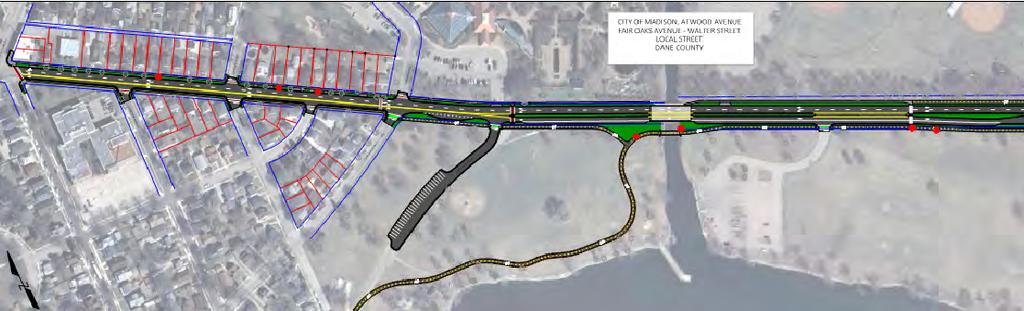
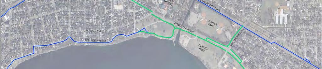
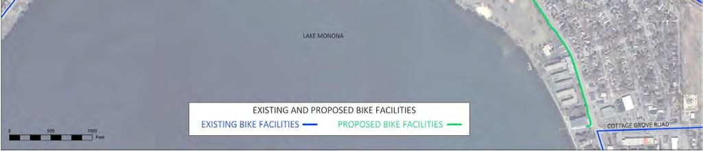
5 Project Location & Limits City of Madison 2021 Construction Fair Oaks Avenue to Cottage Grove Road Olbrich Garden Olbrich Park Lake Monona Cottage Grove Road
6 Section 4(f) Resources City of Madison Lowell School (Section 4(f) Resource) Olbrich Garden (Section 4(f) Resource) Olbrich Park (Section 4(f) Resource) Lake Monona (Section 4(f) Resource) Section 4(f) Resources Cottage Grove Road
7 Project Goals Improve safety and traffic operations while enhancing multimodal connectivity and safety. The proposed project includes: New pavement, curb and gutter, sidewalk 10-foot wide multi-use path along Atwood Avenue in OlbrichPark including a pedestrian bridge crossing of Starkweather Creek. 8-foot wide multi-use path along the south side of Atwood Avenue in Monona. Utilities: storm sewer, sanitary sewer, water main Street Lighting

8 Project Overview Layout


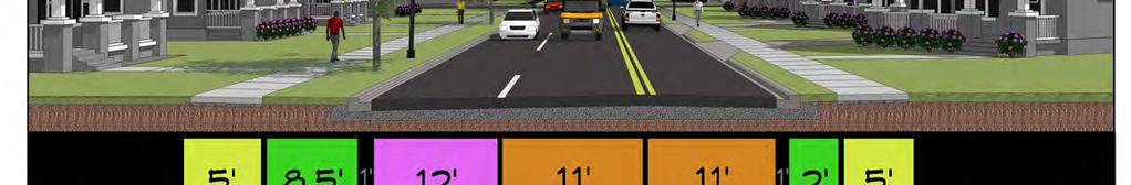

9 Roadway Typical Section

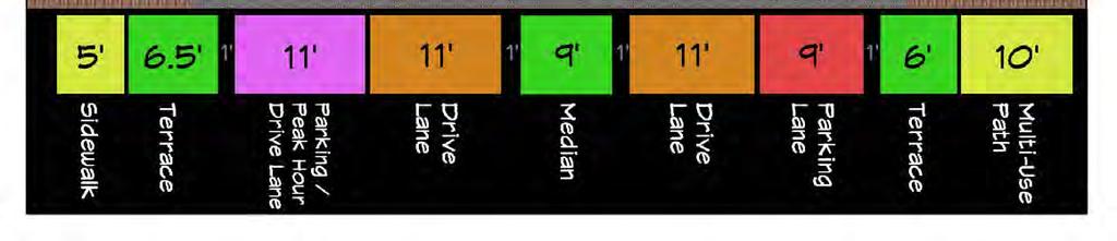
10 Roadway Typical Section


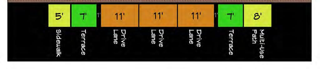
11 Roadway Typical Section

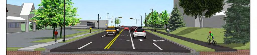
12 Roadway Typical Section

13 Other Alternatives Considered Consideration was given to both a reduction down to a 2-lane roadway and a 3-lane roadway. Why is a 3-lane roadway being recommended?
 Conclusion Not")


14 Other Alternatives Considered Inclusion of on-street bike facilities (4-ft bike lane + 2-ft gutter, 5-ft bike lane with integral curb, 4-ft bike lane+1-ft gutter) Conclusion Not Recommended Each alternative had considerable real estate impacts to both landscaping and buildings between Fair Oaks Avenue and Oakridge Avenue and also near the intersection of Cottage Grove Road. Reduction in lane width from 11-ft desirable to 10- ft minimum. Conclusion Incorporated where feasible Lane reductions are utilized where feasible and necessary to minimize impacts. Alternate bike route connection to Fair Oaks Avenue parallel to Atwood Avenue. Conclusion Not Recommended Property impacts and parkland impacts make this alternative less desirable.


15 Sight Distance Considerations Intersection at Oakridge Avenue with Fair Oaks Sight distance considerations at driveways along bike path in the Monona segment.
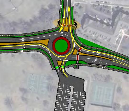
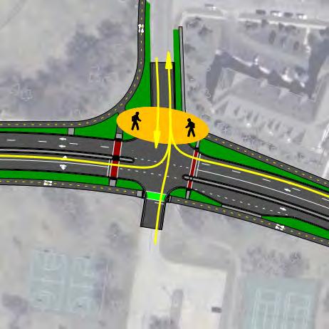
16 Intersection Control Evaluation Evaluate Intersection Alternatives Signal Roundabout
17 Intersection Control Evaluation Evaluation Factors Safety Operational Analysis Construction Cost Right-of-way Access Operation & Maintenance Cost Environment Large Vehicles Pedestrians & Bicycles
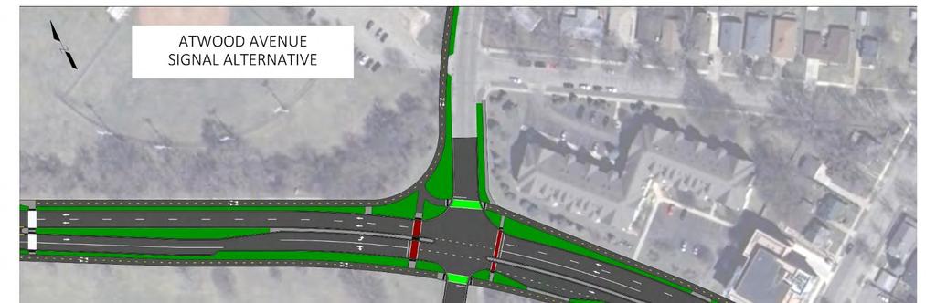
18 Intersection Alternatives-Signal
19 Intersection Alternatives-Roundabout
20 Intersection Alternatives Traffic Signal Provides signal control for pedestrian crossings Less right-of-way is needed Roundabout Slower speeds Safety Better operations, especially for Walter Street during off peak times Less severe crashes
21 Intersection Alternatives-Signal Right of Way Impacts Total R/W Impact = Approximately.58 Acre
22 Intersection Alternatives-Roundabout Right of Way Impacts Total R/W Impact = Approximately.70 Acre
23 Pedestrian and Bike Accommodations Sidewalks 10-foot wide multi-use path along Olbrich Park 8-foot wide multi-use path along south side of Atwood Avenue in Monona to Cottage Grove Road. Colored Crosswalks

24 Pedestrian and Bike Accommodations Bike Connectivity Overview
25 Pedestrian and Bike Conflicts
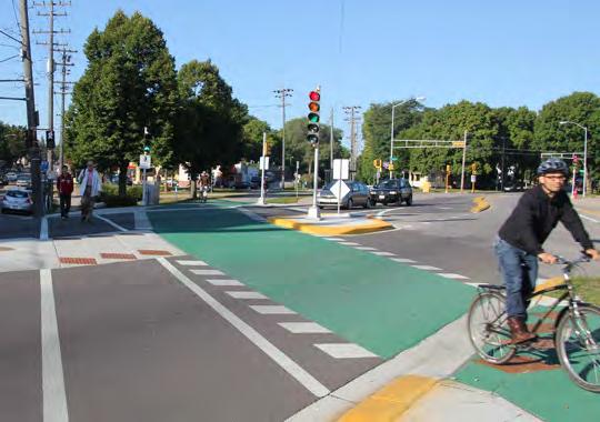
26 Pedestrian/Bike Enhancements
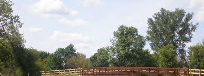
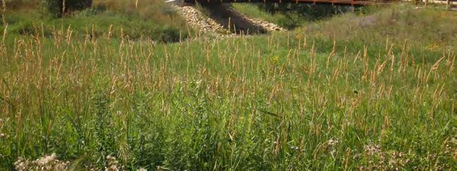
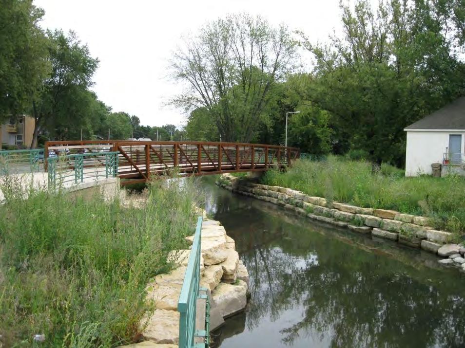
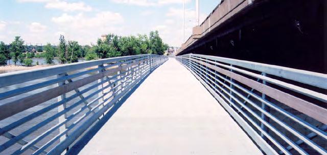
27 Pedestrian/Bike Bridge Aesthetics

28 Other Project Amenities Street Lighting Path Lighting Trees Planted or colored concrete medians
29 Real Estate Additional right of way and/or easements will be required for this project. The city of Madison will be assessing property owners in accordance with city policy.
30 Project Schedule, Funding, and Staging Schedule Fair Oaks Avenue to Cottage Grove Road Construction Anticipated for 2021 Funding Applied for Federal Funds for construction 60% Federal Funds/40% Local Funds Staging Construction includes construction of the preferred intersection alternative at Walter Street. Construction will be staged under traffic maintaining a single lane in each direction.
31 Feedback Sign In Review Exhibits Ask Questions Provide feedback & comments

32

33
City of Madison, East Johnson Street North Baldwin Street to First Street Local Street Dane County
 City of Madison, East Johnson Street North Baldwin Street to First Street Local Street Dane County Public Involvement Meeting Thursday, November 10, 2016 5:30 to 7 P.M. Festival Foods 810 E. Washington
City of Madison, East Johnson Street North Baldwin Street to First Street Local Street Dane County
 City of Madison, East Johnson Street North Baldwin Street to First Street Local Street Dane County Public Involvement Meeting Thursday, April 28, 2016 6 to 8 P.M. Lapham Elementary School 1045 E. Dayton
Poor pavement condition Substandard Intersections. / Substandard bike/pedestrian/transit accommodations. Driveway access Environmental concerns
 Public Informational Meeting University Avenue (Allen Boulevard Segoe Road) March 23, 2011 City of Madison City of Middleton Village of Shorewood Hills Dane County Existing Roadway Conditions Poor pavement
CTH M Reconstruction
 CTH M Reconstruction ID 5992 09 81 City of Madison, South Pleasant View Road (Cross Country Road Prairie Hill Road) CTH M Dane County Public Information Meeting Thursday, May 24, 2012 6 p.m. to 8 p.m.
Building Great Neighbourhoods BELLEVUE AND VIRGINIA PARK
 Building Great Neighbourhoods BELLEVUE AND VIRGINIA PARK This is Meeting 2 Unfortunately, some residents in Bellevue and Virginia Park received the wrong information for this public open house (Meeting
Application of a Complete Street
 Application of a Complete Street Southbend to Prima Vista Update May 14, 2018 Meeting Agenda Perspective and History Public input received Typical sections being considered Presentation of the 2-lane master
CSAH 101 Preliminary Design
 CSAH 101 Preliminary Design Public Open House No. 2 January 29, 2013 CSAH 62 to Hutchins Drive Welcome / Introductions Hennepin County Craig Twinem, Transportation Maury Hooper, Transportation Nick Peterson,
Information on display. Inside this handout. Triangle Area revisions. Project need displays. Preferred alternative on aerial maps
 Public information meeting #4 4 to 7 p.m., September 30, 2009 Hales Corners Welcome Thank you for attending this public information meeting for the WIS 100 Corridor Study. Your interest and comments are
City of Sammamish. Welcome. Issaquah-Fall City Road Improvements Project Phase I Design: 242nd Avenue SE to Klahanie Drive SE
 Welcome Welcome to the third community meeting for the Issaquah-Fall City Road Improvements Project. AGENDA 6:00 p.m. Welcome and sign-in 6:10 p.m. Presentation 6:50 p.m. Open house Learn about the roadway
Tonight is for you. Learn everything you can. Share all your ideas.
 Strathcona Neighbourhood Renewal Draft Concept Design Tonight is for you. Learn everything you can. Share all your ideas. What is Neighbourhood Renewal? Creating a design with you for your neighbourhood.
Preliminary Engineering Study
 Preliminary Engineering Study Open House # 2 June 6, 2018 PREPARED FOR: PREPARED BY: Agenda Background and status of preliminary engineering study County Road 26 design summary County Road 63 design summary
GARLAND ROAD/GASTON AVENUE/ GRAND AVENUE INTERSECTION IMPROVEMENT STUDY
 MEETING OF AFFECTED PROPERTY OWNERS AND STAKEHOLDERS GARLAND ROAD/GASTON AVENUE/ GRAND AVENUE INTERSECTION IMPROVEMENT STUDY CSJ 0009-02-067 Meeting Agenda 1 2 3 4 5 6 7 8 9 10 Opening Remarks State Representative
Public Information Meeting. Orange Camp Road. Dr. Martin Luther King Jr. Beltway to I-4. Presented by: Volusia County August 2, 2018
 Public Information Meeting Orange Camp Road Dr. Martin Luther King Jr. Beltway to I-4 Presented by: Volusia County August 2, 2018 1 Project Goals To improve the operations and safety for Orange Camp Road
RIVERSIDE, Newton MA BH NORMANDY RIVERSIDE LLC. Riverside Station. A green, transit-oriented community
 Riverside Station A green, transit-oriented community October 6, 2011 TONIGHT S AGENDA: 1. Project Update (5 min.) 2. Master Plan Update (10 min.) 3.Traffic Plan Update (10 min.) Questions & Answers MASTER
Complete Streets Policy DAVID CRONIN, P.E., CITY ENGINEER
 Complete Streets Policy DAVID CRONIN, P.E., CITY ENGINEER Complete Streets City Commission adopted a Complete Streets policy in 2012 Complete Streets are road networks that are designed for all users:
Intersection Improvement: Sturgeon Road, Silver Avenue and Murray Park Road Roundabout. Welcome. Public Information Session
 Intersection Improvement: 1 Welcome WHY IS AN INTERSECTION IMPROVEMENT NEEDED? 2 Traffic volumes for Sturgeon Road, Silver Avenue and Murray Park Road exceed the capacity of the existing 4-way stop controlled
2014/2015 BIKE ROUTE PLAN 83 AVENUE PROTECTED BIKE LANE
 About the Project The City of Edmonton is planning a major bike route on the southside of Edmonton. The Strathcona Bike Route will connect the communities of Strathcona, Garneau and the University area,
6.4 RECOMMENDED IMPROVEMENTS
 6.4 RECOMMENDED IMPROVEMENTS 6.4.1 Williston Road Recommendations While all alternatives would be an improvement over existing conditions, Alternative 3B is recommended over the others because it provides
Building Great Neighbourhoods QUEEN ALEXANDRA
 Building Great Neighbourhoods QUEEN ALEXANDRA We are here today to Explain how the City is investing in improving your neighbourhood and how your neighbourhood will be improved to meet current City standards.
Building Great Neighbourhoods LANSDOWNE
 Building Great Neighbourhoods LANSDOWNE We are here today to Explain how the City is investing in improving your neighbourhood and how your neighbourhood will be improved to meet current City standards.
DISTRICT BICYCLE PROGRAM
 DISTRICT BICYCLE PROGRAM TxDOT Fort Worth District Public Hearing Bicycle Use on the State Highway System Public Hearing Agenda 1 2 3 4 5 6 Introduction Susan Howard TxDOT Public Involvement Specialist
Board of Supervisors February 27, 2017
 : Traffic Analysis Results & Draft Conceptual Plan Board of Supervisors February 27, 2017 Transportation Solutions Building Better Communities Presentation Overview Background Summary of Traffic Analysis
2014/2015 BIKE ROUTE PLAN 83 AVENUE PROTECTED BIKE LANE
 About the Project 2014/2015 BIKE ROUTE PLAN The City of Edmonton is planning a major bike route on the south side of Edmonton. This bike route is one part of a plan to provide citizens with transportation
Dr. M.L. King, Jr. Street North Complete Streets Resurfacing Opportunities HOUSING, LAND USE, AND TRANSPORTATION COMMITTEE MARCH 22, 2018
 Dr. M.L. King, Jr. Street North Complete Streets Resurfacing Opportunities HOUSING, LAND USE, AND TRANSPORTATION COMMITTEE MARCH 22, 2018 What s Happening The City plans to mill and resurface Dr. M.L.
Engineering - Bicycle and Pedestrian
 Capital Improvement Plan Project Summary # Bikeways Program 781,000 860,000 900,000 933,000 933,000 933,000 # Cannonball Path 1,200,000-780,000 - - - # Capital City Trail - 70,000 - - 910,000 - # Goodman
Brooklyn Boulevard (County Road 152) Reconstruction Project Phase I. OPEN HOUSE June 20, 2017
 Reconstruction Project Phase I. OPEN HOUSE June 20, 2017") Brooklyn Boulevard (County Road 152) Reconstruction Project Phase I OPEN HOUSE June 20, 2017 Brooklyn Boulevard (County Road 152) Phase I Project Partners Project Lead Other Project Partners include Brooklyn
Brooklyn Boulevard (County Road 152) Reconstruction Project Phase I OPEN HOUSE June 20, 2017 Brooklyn Boulevard (County Road 152) Phase I Project Partners Project Lead Other Project Partners include Brooklyn
Building Great Neighbourhoods BONNIE DOON
 Building Great Neighbourhoods BONNIE DOON We Are Here Today To Explain the Neighbourhood Renewal Process Show you the Westwood Preliminary Design Ask for local knowledge Highlight the Local Improvement
01. VICINITY OF GREENBRAE POC: EXISTING CONDITIONS
 01. VICINITY OF GREENBRAE POC: EXISTING CONDITIONS Existing Bus Stop Existing US101 On-ramp Existing POC Old Redwood Highway Rich Street City ROW Environmental Study Limit Industrial Way NO DESIGNATED
Route 47 (North Main Street) Reconstruction
 Reconstruction") TOWN OF SUNDERLAND Route 47 (North Main Street) Reconstruction Presented by Lou Rabito, P.E. Presented to Town of Sunderland June 11, 2018 Project Overview MassDOT Project No. 607245 Resurfacing and Related
TOWN OF SUNDERLAND Route 47 (North Main Street) Reconstruction Presented by Lou Rabito, P.E. Presented to Town of Sunderland June 11, 2018 Project Overview MassDOT Project No. 607245 Resurfacing and Related
Ocean Park Boulevard Green Street Project Alternatives & Trade Offs
 Planning Commission March 4, 2009 Ocean Park Boulevard Green Street Project Alternatives & Trade Offs Purpose of Tonight s Meeting Review concept plans and options Provide input on alternatives and trade-offs
Item No. 14 Town of Atherton
 Item No. 14 Town of Atherton CITY COUNCIL STAFF REPORT CONSENT AGENDA TO: THROUGH: FROM: HONORABLE MAYOR AND CITY COUNCIL GEORGE RODERICKS, CITY MANAGER MICHAEL KASHIWAGI, COMMUNITY SERVICES DIRECTOR MARTY
Ocean Park Boulevard Streetscape Improvement Project Alternatives & Trade Offs
 City Council Study Session January 27, 2009 Ocean Park Boulevard Streetscape Improvement Project Alternatives & Trade Offs Scope of Work Purpose of Tonight s Meeting Review work to date and direct staff
THE ALAMEDA CONCEPT DESIGN COMMUNITY MEETING 3. A Plan for The Beautiful Way JANUARY 28, 2010
 CONCEPT DESIGN COMMUNITY MEETING 3 JANUARY 28, 2010 AGENDA INTRODUCTION COMMUNITY INPUT ROADWAY STUDIES STREETSCAPE DESIGN STATIONS DISCUSSION SUMMARY AND DISCUSSION NEXT STEPS CLOSE INTRODUCTION SCHEDULE
Pine Hills Road Pedestrian/Bicycle Safety Study Board of County Commissioners Work Session
 Pine Hills Road Pedestrian/Bicycle Safety Study Board of County Commissioners Work Session February 20, 2018 Meeting Agenda Study Overview Existing Conditions Access Management Potential Gateway Features
WELCOME. City of Eden Prairie West 70 th Street
 WELCOME City of Eden Prairie West 70 th Street Project Schedule Sep Oct Nov Dec Jan Feb Mar Apr May Jun Jul Aug >>> May WEST SEGMENT Concept Plan Fall 2014 Plan Development Winter 2014 Summer 2015 Construction
Pre-Construction Meeting
 Pre-Construction Meeting Wednesday, March 21 Drop-in from 5 9pm Please visit displays for project information, talk to staff, and ask questions! Edmonton.ca/SouthsideBikeRoutes Objectives & Project Scope
5 CIRCULATION AND STREET DESIGN
 5 CIRCULATION AND STREET DESIGN This chapter describes circulation and streetscape improvements proposed for the Northwest Chico Specific Plan Area. It includes detailed design specifications for existing
Columbia Pike Implementation Team (CPIT) Meeting
 Meeting") Columbia Pike Implementation Team (CPIT) Meeting November 30, 2010 Agenda Introductions / Purpose of Meeting Review of project goals Multimodal project: 10% street design between the curbs Discussion Multimodal
Columbia Pike Implementation Team (CPIT) Meeting November 30, 2010 Agenda Introductions / Purpose of Meeting Review of project goals Multimodal project: 10% street design between the curbs Discussion Multimodal
Intersection Design. Leah Ness, Craig Hardy and Eric Sorensen
 Intersection Design Leah Ness, Craig Hardy and Eric Sorensen OVERVIEW TYPES OF INTERSECTIONS SCOPING COORDINATION INTERSECTION EVALUATION HORIZONTAL AND VERTICAL LAYOUTS DESIGN COORDINATION CONSTRUCTION
Road Diets FDOT Process
 Florida Department of TRANSPORTATION Road Diets FDOT Process Humberto Castillero, PE, PTOE Roadway Design Office Purpose of Guide Develop a statewide lane elimination review process Balance state & local
US 278 Corridor Concept Presentation. Avondale Estates Intersection Improvement/Roundabout and Road Diet Feasibility Study March 19, 2015
 US 278 Corridor Concept Presentation Avondale Estates Intersection Improvement/Roundabout and Road Diet Feasibility Study March 19, 2015 Thanks to our Partners Atlanta Regional Commission Georgia Department
CONNECTIVITY PLAN. Adopted December 5, 2017 City of Virginia Beach
 CONNECTIVITY PLAN Adopted December 5, 2017 City of Virginia Beach CONTENTS 1.0 Background & Purpose... 2 2.0 Existing Inventory & Analysis... 3 ViBe District Existing Walking Conditions... 4 3.0 ViBe District
City of Albert Lea Policy and Procedure Manual 4.10 ALBERT LEA CROSSWALK POLICY
 4.10 ALBERT LEA CROSSWALK POLICY PURPOSE: Pedestrian crosswalks are an integral part of our transportation infrastructure. To be effective and promote safety, marked crosswalks must be installed after
Southbend to Prima Vista. October 30, Floresta Corridor Master Plan
 Application of a Complete Street initiative and how it might function operationally 8 8 Southbend to Prima Vista October 30, 2017 Presentation Agenda 2 Perspective and History Traffic projections, Levels
Derby Street. Project Updates. Salem, Massachusetts
 Derby Street Project Updates Salem, Massachusetts September 13, 2017 Project Limits Derby Street Project Objectives 1. Improve complete streets elements on Derby Street 2. Improve sidewalks on finger streets
C C C
 C-012-001 Thank you for your support for the creation of new public space and nonmotorized access between downtown and the waterfront through the Overlook Walk, the East-West Connections, and the Promenade.
Clybourn Ave. Protected Bike Lane Study Halsted St. to Division St.
 Clybourn Ave. Protected Bike Lane Study Halsted St. to Division St. Nathan Roseberry, Senior Engineer Pam Broviak, Project Manager July 24, 2014 Agenda Project Goals Existing Roadway Conditions Traffic
APPENDIX L: COST ESTIMATING TOOLS
 APPENDIX L: COST ESTIMATING TOOLS Rural Arterial From LRE MOT * Mobilization * Subtotal Scope Contingency (25%) Total PE Design (15%) CEI (15%) Total Project ** New (2-Lane Roadway) with 5' Paved Shoulders
RZC Appendix 8A Marymoor Subarea Street Requirements
 RZC Appendix 8A Marymoor Subarea Street Requirements For additional design details for Marymoor Subarea infrastructure, refer to the 2017 Marymoor Subarea Infrastructure Planning Report. STREET REQUIREMENTS
NORTH DOWNTOWN N EAST WEST
 ORTH DOWTOW CHURCH STREET ALTERATE o. 1 BIKE LAES, O-STREET PARKIG, SIDEWALK AD MULTI-USE PATH This alternate incorporates a 5-foot sidewalk along the eastern side of Church Street, a 10-foot Multi-Use
Commerce Street Complete Street Project from Good Latimer Expressway to Exposition Avenue
 Commerce Street Complete Street Project from Good Latimer Expressway to Exposition Avenue T A N Y A B R O O K S A S S I S T A N T D I R E C T O R M O B I L I T Y P L A N N I N G M O B I L I T Y A N D S
East Burke Transportation, Safety and Capacity Improvements
 East Burke Transportation, Safety and Capacity Improvements The purpose of this project is to increase mobility and improve safety for pedestrians, cyclists, and motor vehicles along VT Route 114 in the
5. RUNNINGWAY GUIDELINES
 5. RUNNINGWAY GUIDELINES These guidelines should be considered collectively when making runningway decisions. A runningway is the linear component of the transit system that forms the right-of-way reserved
General Plan Circulation Element Update Scoping Meeting April 16, 2014 Santa Ana Senior Center, 424 W. 3rd Street, Santa Ana, CA 92701
 General Plan Circulation Element Update Scoping Meeting April 16, 2014 Santa Ana Senior Center, 424 W. 3rd Street, Santa Ana, CA 92701 Meeting Agenda 1. Purpose of Scoping Meeting 2. Project Overview 3.
MAG Town of Cave Creek Bike Study Task 6 Executive Summary and Regional Significance Report
 Page 1 MAG Town of Cave Creek Bike Study Task 6 Executive Summary and Regional Significance Report August 1, 2012 MAG Project #481 Page 2 Task 6 Executive Summary and Regional Significance Report Introduction
City of Gainesville Transportation/Roadway Needs PROJECT SUMMARY
 A1 Roadway Resurfacing $23,846,000 TYPE: Preservation of existing system Roadway resurfacing A2 Signal Replacement $6,000,000 TYPE: Preservation of existing system Replace traffic signals. B1 W 6th St
Southview Blvd & 3 rd Avenue Improvement Project. Public Open House December 4, to 7pm
 Southview Blvd & 3 rd Avenue Improvement Project Public Open House December 4, 2014 5 to 7pm Southview Blvd & 3 rd Avenue Public Information Meeting Agenda Presentation 5:30 to 6:15 pm Purpose of Project
Mark Malone, P.E. SD DOT
 Mark Malone, P.E. SD DOT SD10 Grading & Surfacing From 8 th Ave W to 8 th Ave E 1 mile plus transition lengths Complete Urban Reconstruction Grading, C&G, Storm Sewer, Sidewalk, Concrete Surfacing Railroad
STEERING COMMITTEE MEETING June 17, Streetscape Overview Burlington Comprehensive Master Plan
 STEERING COMMITTEE MEETING June 17, 2015 Streetscape Overview Burlington Comprehensive Master Plan 1 Introduction Slide This slide show was presented to the Burlington Steering Committee on June 17, 2015
Multimodal Design Guidance. October 23, 2018 ITE Fall Meeting
 Multimodal Design Guidance October 23, 2018 ITE Fall Meeting Introductions Jessica Wilson TDOT Multimodal Division Office of Multimodal Planning Program Supervisor Jessica.L.Wilson@tn.gov Ali Hangul TDOT
Hennepin Avenue Reconstruction Washington Avenue to 12 th Street
 CITY OF MINNEAPOLIS Hennepin Avenue Reconstruction Washington Avenue to 12 th Street April 2016 1 Upcoming Opportunities Public Meeting #2 April 25, 2016 Minneapolis Central Library Doty Board Room Repeat
STANLEY STREET December 19, 2017
 STANLEY STREET December 19, 2017 Welcome Mike Wiza, Mayor Scott Beduhn, Director of Public Works Agenda 1. Introduction 2. Existing Roadway Conditions 3. Current Alternative Improvements 4. Summary of
Saskatchewan Drive Roadway Rehabilitation and Shared-Use Path Widening
 Saskatchewan Drive Roadway Rehabilitation and Shared-Use Path Widening We are here today to present the draft plan for the Saskatchewan Drive Roadway Rehabilitation and Shared-Use Path Widening project
Downtown Naples Mobility and Connectivity Study. Naples City Council Presentation January 2017
 Downtown Naples Mobility and Connectivity Study Naples City Council Presentation January 2017 Agenda 1. Introduction 2. Scope Review 3. Project Schedule 4. Existing Conditions 5. Public Charrette 6. Mobility
Pine Hills Road Pedestrian/Bicycle Safety Study Community Meeting #1
 Pine Hills Road Pedestrian/Bicycle Safety Study Community Meeting #1 June 8, 2017 Meeting Agenda Study Overview Community Survey Existing Conditions Access Management Potential Safety Countermeasures Potential
TRANSPORTATION FACILITY PLANNING Waugh Chapel Road Maytime Drive to New Market Lane
 July 24, 2018 TRANSPORTATION FACILITY PLANNING Waugh Chapel Road Maytime Drive to New Market Lane DPWandYOU.com Making a difference, together Meeting Agenda Purpose of the project Overview of work conducted
Controlled. Semi-Controlled PAGE 01 CHAPTER 12 INTERSECTIONS
 PAGE 01 CHAPTER 12 INTERSECTIONS You will cross many intersections while driving. Intersections are especially dangerous because vehicles are crossing each other s driving path. Many crashes happen at
In station areas, new pedestrian links can increase network connectivity and provide direct access to stations.
 The Last Mile Planning for Pedestrians Planning around stations will put pedestrians first. Making walking to stations safe and easy is important; walking will be a part of every rapid transit Accessible
Monroe Street Reconstruction
 Total participants: 45+ Monroe Street Reconstruction Cross Section Workshop Notes September 29, 2016, Wingra School Workshop Orientation, Technical and Functional Considerations: The workshop began with
What Is a Complete Street?
 Session 5 Charleen Zimmer, AICP, Zan Associates May 5-7, 2010 What Is a Complete Street? May 2010 5-1 Not a Complete Street More of a Complete Street May 2010 5-2 Benefits of Complete Streets Safety for
Moving Together Conference Complete Streets from the MassDOT District 5 Perspective
 Moving Together Conference Complete Streets from the MassDOT District 5 Perspective Timothy Kochan, Transportation Planner and Bicycle/ Pedestrian Coordinator District 5 Office Taunton S Overview of District
Item to be Addressed Checklist Consideration YES NO N/A Required Description Complete Streets Guidelines
 Passaic County Complete Streets Checklist - Concept Development Project Name Item to be Addressed Checklist Consideration YES NO N/A Required Description Complete Streets Guidelines Existing Plans Have
Beach Cities Living Streets Design Manual and Aviation Boulevard Multimodal Corridor Plan
 Beach Cities Living Streets Design Manual and Aviation Boulevard Multimodal Corridor Plan AGENDA 1 Introductions & Project Scope 2 Public Outreach Recap 3 Living Streets Design Manual 4 Aviation Boulevard
CHAPTER 16 PEDESTRIAN FACILITIES DESIGN AND TECHNICAL CRITERIA TABLE OF CONTENTS
 CHAPTER 16 PEDESTRIAN FACILITIES DESIGN AND TECHNICAL CRITERIA TABLE OF CONTENTS Section Title Page 16.1 General... 16-1 16.1.1 AASHTO Reference... 16-1 16.1.2 ADA Requirements... 16-1 16.2 Sidewalks...
BETHEL ROAD AND SEDGWICK ROAD CORRIDOR STUDY
 DRAFT PLAN City Council Meeting August 14, 2017 STUDY AREA Sedgwick Corridor State Route 160, principal arterial with Class 3 access management designation, commuter and freight route, connection to SR
Fleur Drive Reconstruction
 Fleur Drive Reconstruction October 29, 2018 1 Agenda: Fleur Drive Reconstruction Project Scope & Cost Overview Fleur Drive Cross Section Elements - Travel Lane Widths - Sidewalk Widths - Parkway Widths
Chapter 2: Standards for Access, Non-Motorized, and Transit
 Standards for Access, Non-Motorized, and Transit Chapter 2: Standards for Access, Non-Motorized, and Transit The Washtenaw County Access Management Plan was developed based on the analysis of existing
Bicycle and Pedestrian Facilities Toolbox (Excerpt from Figure 3.1)
") Appendix B Neighborhood Connections Summaries This Appendix is a supplement to the information presented in Chapter 3 Connect People. The Appendix includes a summary or profile for each of the proposed
Appendix B Neighborhood Connections Summaries This Appendix is a supplement to the information presented in Chapter 3 Connect People. The Appendix includes a summary or profile for each of the proposed
Washington St. Corridor Study
 FIGURE 7.17 Bridge Alternatives - Cross Sections 86 Discarded Alternative: Short-Term Bridge Repair Short-term repairs and west bridge span replacement were considered during analysis. Short-term repairs
TRANSPORTATION COMMISSION East 19 th St, Harper to O Connell Thursday, March 29, :00 PM City Commission Room, City Hall, 6 E.
 TRANSPORTATION COMMISSION East 19 th St, Harper to O Connell Thursday, March 29, 2018 6:00 PM City Commission Room, City Hall, 6 E. 6th Street AGENDA Public comment related to the meeting topic will be
83 AVENUE PRE-CONSTRUCTION MEETING
 83 AVENUE PRE-CONSTRUCTION MEETING April 6, 2017 5-8PM Please visit displays for project information Talk to staff, ask questions, visit website at: www.edmonton.ca/bike83avenue Pre-Construction Meeting
Complete Street Analysis of a Road Diet: Orange Grove Boulevard, Pasadena, CA
 Complete Street Analysis of a Road Diet: Orange Grove Boulevard, Pasadena, CA Aaron Elias, Bill Cisco Abstract As part of evaluating the feasibility of a road diet on Orange Grove Boulevard in Pasadena,
PROJECT OBJECTIVES. Improve vehicle capacity for the intersection. Improve pedestrian and bicycle access
 COMMUNITY MEETING Project Update March 15, 2010 Purcellville, Virginia OVERVIEW Project need / objectives Project recap Design elements Proposed improvements Summary of project benefits / next steps PROJECT
Overview. Illinois Bike Summit IDOT Complete Streets Policy Presentation. What is a Complete Street? And why build them? And why build them?
 Overview Illinois Bike Summit IDOT Complete Streets Policy Presentation Aren Kriks, P.E. District One Bicycle Coordinator and Bureau of Programming Project Engineer History of Complete Streets IDOT Policy
Public Works Committee Meeting Richard E. Mastrangelo Council Chamber November 20, 2017
 Public Works Committee Meeting Richard E. Mastrangelo Council Chamber November 20, 2017 Purpose of Meeting Why are we here? Project Recap/Updates Project Limits/Segments Road Diet Concept Lessons Learned
FOCUS AREA 1 - Alberta Avenue Pocket Park 3 (121 Ave and 92 St)
") FOCUS AREA 1 - Alberta Avenue Pocket Park 3 (121 Ave and 92 St) New benches Plant evergreen trees Widen existing sidewalk from 1.5m to 1.8m Marked crosswalk 1.8m wide sidewalk Add pedestrian oriented lights
FOCUS AREA 1 - Alberta Avenue Pocket Park 3 (121 Ave and 92 St) New benches Plant evergreen trees Widen existing sidewalk from 1.5m to 1.8m Marked crosswalk 1.8m wide sidewalk Add pedestrian oriented lights
Mission-Geneva Transportation Study Community Workshop 2 July 8, 2006
 Community Workshop 2 July 8, 2006 Small Group Workbook 1 Basic Improvements on Mission Street Streetscape. Pedestrian-scale lighting; landscaping; community art on utility boxes; more (possibly unique)
Southcote Road Improvements Class Environmental Assessment Study
 1 Southcote Road Improvements Class Environmental Assessment Study Public Information Centre #1 May 24, 2018 Study Area 2 3 Welcome The Ancaster Transportation Master Plan (2011) outlined a long range
20 minute presentation on proposed project. Comments and Questions following presentation. City of Madison
 20 minute presentation on proposed project Comments and Questions following presentation 2016 2017 Replace concrete pavement & base Replace curb and sidewalk as needed Proposed contra-flow bike lane Replace
TRANSPORTATION STANDARDS
 INTRODUCTION LOCAL STREETS ON-STREET PARKING SIDEWALKS STREET LIGHTING STREET FURNISHINGS TRAFFIC CALMING STREET TREES MEDIAN PLANTING BOULEVARD LOCATIONS VILLAGE CENTER STREET LOCATIONS RESIDENTIAL STREET
West Dimond Blvd Upgrade Jodhpur Street to Sand Lake Road
 West Dimond Blvd Jodhpur St to Sand Lake CSS Transportation Project Summary Municipality of Anchorage Project # 05 005 Project Manager: John Smith, P.E. (MOA PM&E) Project Administrator: Julie Makela,
WELCOME. Stakeholder Involvement Group Meeting #2 Round Lake Public Works October 24, 2018
 WELCOME Stakeholder Involvement Group Meeting #2 Round Lake Public Works October 24, 2018 MEETING AGENDA 1. Welcome and Introductions 2. Study Progress Update 3. Problem Statement 4. Technical Analysis
Operations -- Transit From: N/A To: N/A. Improvement Type: Regionally Significant: No
 Central Puget Sound Regional 2017-2020 Transportation Improvement Program Amendments and Corrections to be included in the 2017-20 STIP PSRC's Amendment 2017-08 County: King List of 17-08 Amendment Projects:
10A. DATE: October 5, Pedestrian and Bicycle Advisory Committee. Kevin Colin, Deputy Planning Manager Curt Bates, City Engineer
 10A DATE: October 5, 2016 TO: PREPARED BY: SUBJECT: Pedestrian and Bicycle Advisory Committee Kevin Colin, Deputy Planning Manager Curt Bates, City Engineer Discussion and Provide Comments, Associated
Final Sidewalk Feasibility Study
 Garfield Drive From Anastasia Drive to Elizabeth Place City of South Daytona July 23, 2009 Final Sidewalk Feasibility Study Prepared for: Prepared by: Final Sidewalk Feasibility Study Garfield Drive 2
F L E T C H E R A V E N U E
 Jan. 29, 2014 Introduction F L E T C H E R A V E N U E FDOT Local Agency Program (LAP) Project FPN: 428214-1-58-01 CIP 63090 Hillsborough County, Traffic Engineering, PWD Stake holders and partners are
Water Street Promenade. Engineering and Design Services. Public Information Meeting No. 2. Education / Infrastructure / Innovation. Maplewood Avenue &
 Public Information Meeting No. 2 Water Street Promenade Maplewood Avenue & Engineering and Design Services Adjacent Areas July 16,2014Portsmouth, NH May 10, 2016 Education / Infrastructure / Innovation
WELCOME. to the meeting for the. Westside Avenue Action Plan Gateway to Revitalization
 WELCOME to the meeting for the Columbia Road - Before and After Ridge Road - Before and After Before and After WAAP Bridge Sections Fountain Creek Before Retaining Wall for Roadway 30' Existing Fountain
Colchester/Riverside/Barrett/ Mill Intersection Study. PAC Meeting #3 September 22, 2016
 Colchester/Riverside/Barrett/ Mill Intersection Study PAC Meeting #3 September 22, 2016 Tonight s Agenda Review Project Purpose and Need Describe short term and long improvements and changes since public
INDEX. Geometric Design Guide for Canadian Roads INDEX
 Acceleration lane, see Lanes, Acceleration Access, 8.1 Access Management and Functional Classification 8.2 Access Management by Design Classification 8.3 Access Configuration 8.4 Building Set-Back Guidelines