TOWN OF WINDSOR AGENDA REPORT
|
|
|
- Olivia Terry
- 6 years ago
- Views:
Transcription
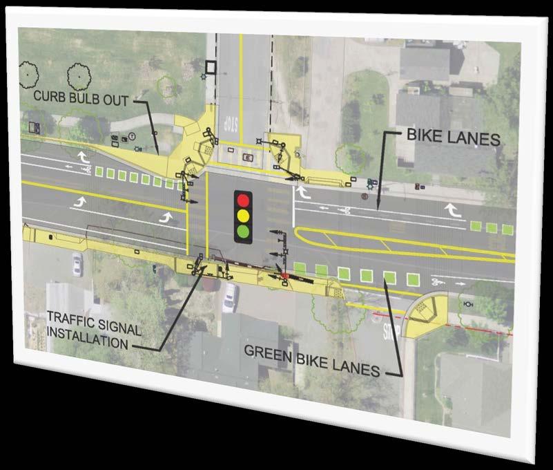
1 ITEM NO. : 8.3 TOWN OF WINDSOR AGENDA REPORT Joint Town Council and Windsor Unified School District Board of Trustees Meeting Date: February 16, 2016 To: From: Subject: Mayor and Council Members Board Chair and Members Alejandro Perez, Senior Civil Engineer Informational Report on the Town of Windsor Transportation Program Recommendation to Council and Board of Trustees: Receive a presentation on the Town of Windsor Transportation Program for fiscal year 2016 which includes bicycle and pedestrian projects that will benefit the Windsor Unified School District. Background: The Town of Windsor is currently in the first year of the biennium budget. For the Transportation Program, approximately $3.8 million was budgeted in fiscal year and $2.8 million was budgeted in fiscal year The focus of this agenda report is on the current year transportation work plan which includes projects and studies that may be of interest to the Windsor Unified School District (WUSD) community. These projects are intended to increase pedestrian and/or bicyclist activity with a focus on school-related travel safety. An update for the Safe Routes to School Program (SRTS) and the Old Redwood Highway roadway improvements associated with the Bell Village Development Project is also provided. Discussion: The following projects are grouped into four categories and described below. Information regarding project budget and schedule can be found in the attachment to the agenda report. Intersection Improvements: Traffic Signal at Windsor Road/Jaguar Way - The installation of this traffic signal and sidewalk will improve access to Windsor High School. Additional improvements include a parking lane and right turn lanes along the Windsor High School frontage. Traffic Signal at Windsor River Road/Market Street/Bell Road - The installation of this traffic signal will provide pedestrian safety improvements and improve traffic operations at this location. Road Realignment at Conde Lane/Johnson Street Conde Lane will be realigned to provide a 90 degree curve at Johnson Street. Access to Johnson Street will be limited to a right turn in/right turn out. Additional improvements include a sidewalk gap closure in front of the Redwood Royale Apartments. The improvements will improve pedestrian safety and traffic operations at this location. Windsor Creek Elementary School is located on Conde, south of this location. Windsor River Road/Windsor Road Intersection Reconfiguration Intersection reconfiguration options include a roundabout or a modified traffic signal at this location. 1 of 3
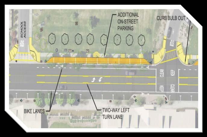
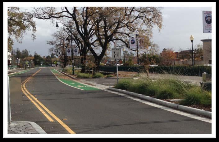
2 Pedestrian and Bicycle Improvements: Starr Road Sidewalk Gap Closure - Sidewalk improvements were recently completed along the east side of Starr Road between the existing sidewalks near Estrella s Market and the Head Start Pre-school. Additional sidewalk improvements are planned for the east side of Starr Road across from Cali Calmecac School. Windsor Road Sidewalk Gap Closure - Sidewalk improvements were completed along the east side of Windsor Road along the Wastewater Treatment Plant between Winemaker Way and Reiman Lane. The installation of streets lights has been delayed pending resolution of the collection of the contractor s performance bond due to the contractor s inability to complete the work. Starr Creek/Keiser Park Trail Connection - The project includes extending the existing Starr Creek Trail behind Windsor High School to Keiser Park. Planning Studies/Programs: Safe Routes to School Program (SRTS) - A grant was awarded to the Town for development and implementation of a town-wide program to educate, encourage, enforce and evaluate various school age pedestrian and bicycle activities. Program activities include walking audits at the five elementary/middle schools in Windsor, parent education workshops and inclassroom activities, purchase of a bicycle fleet and helmets, a public awareness campaign, additional traffic enforcement in school areas, and other incentivized activities. The SRTS Program is in the final year of the 3 year program. Downtown Pedestrian Crossing of US 101 Study - The study is to review alternatives for crossing US 101 near the central Windsor interchange to serve non-vehicular travel. Jaguar Way Concept Plan Development of a concept plan is planned for fiscal year The concept plan will evaluate roadway alternatives for Jaguar Way between Windsor Road and Starr Road. Starr Road pedestrian connectivity between Jaguar Way and Windsor River Road will also be considered with development of the Jaguar Way Concept Plan. Development: Old Redwood Highway Improvements at Bell Village - The Bell Village Project is a new development located on 25 acres on Old Redwood Highway across from the Town Green. This includes 19 acres of residential (apartments) and 6 acres of commercial. Old Redwood Highway improvements associated with the Bell Village Project include sidewalks, green bicycle lanes, angled/parallel parking, street lighting, landscaping, and roundabouts at the intersections of Market Street/Old Redwood Highway and Windsor Road/Old Redwood Highway. The first phase of the Old Redwood Highway improvements have been completed between Joe Rodota and Windsor River Road. The second phase between Windsor Road and Joe Rodota is anticipated to be completed by April Windsor Mill A new tentative map for the Windsor Mill Project is anticipated to be submitted by the applicant in The 20 acre project site is located on Bell Road, south of Windsor River Road, between Windsor Creek and the SMART railroad right-of-way. Public improvements associated with the project include the extension of Bell Road, a paved trail adjacent to the SMART right-of-way and a paved trail along Windsor Creek which includes a pedestrian bridge connection to Windsor Creek Elementary. 2 of 3
3 Fiscal Impact: None. Environmental Review: None. Attachments: 1. Location Map of Town of Windsor Transportation Projects 2. Schedule/Funding Information Table 3. PowerPoint Presentation Prepared By: Alejandro Perez Senior Civil Engineer Recommended By: Linda Kelly Town Manager Reviewed By: Stuart Hayre Acting Public Works Director/Town Engineer I:\80 - Public Works\Admin\Agenda Reports\2016\ \WUSD\ Agenda Report - Transportation Program Overview for Joint Town - WUSD Meeting.docx 3 of 3

4 Conde Ln Attachment No. 1 Old Redwood Hwy 5 Arata Ln B R O O K S E L E M E N TA R Y Brooks Rd W I N D S O R M I D D L E Starr Rd C A L I C A L M E C A C L A N G U A G E A C A D E M Y Los Amigos Rd WUSD Office Windsor River Rd Starr Rd 7 10 W I N D S O R H I G H W I N D S O R C R E E K E L E M E N TA RY Old Redwood Hwy Hembree Ln M AT T IE W A S H B U R N E L E M E N TA RY Pleasant Ave 6 Conde Ln Reiman Ln Mitchell Ln Old Redwood Hwy Windsor Rd In te rsec tio n Im p rovem en ts 1. Traffic Signal at Windsor Road/Jaguar Way 2. Traffic Signal at Windsor River Road/Market Street/Bell Road 3. Conde Lane/Johnson Street Realignment 4. Windsor River Road/Windsor Road Intersection Improvements Ped estria n an d B ic yc le Im provem en ts 5. Starr Road Sidewalk Gap Closure 6. Windsor Road Sidewalk Gap Closure 7. Starr Creek/Keiser Park Trail Connection P la nn in g Stud ies/p rogram s 8. Safe Routes to School Program (SRTS) (Not on Map) 9. Downtown Pedestrian Crossing of US 101 Study 10. Jaguar Way Concept Plan D evelo pm en t 11. Old Redwood Highway Improvements at Bell Village 12. Windsor Mill Development Improvements Hembree Ln Shiloh Rd A Joint Meeting of Town of Windsor Town Council and Windsor Unified School District Board of Trustees February 2016
5 TOWN OF WINDSOR Public Works Department Transportation Projects/Studies/Programs Attachment No. 2 Description Project Schedules Funding Intersection Improvements: 1 Traffic Signal at Windsor Road/Jaguar Way Begin Design: Fall 2014 Construction: 2016 $1,268,000 Source: Grant and General Fund 2 Traffic Signal at Windsor River Road/Market Street/Bell Road Design: 2016 Construction: 2017 $703,500 Source: Grant and General Fund 3 Conde Lane/Johnson Street Realignment Design: 2016 Construction: 2017 $593,000 Source: Grant and General Fund 4 Windsor River Road/Windsor Road Intersection Reconfiguration Preliminary Design: $200,000 Source: General Fund Pedestrian and Bicycle Improvements: 5 Starr Road Sidewalk Gap Closure Design: 2015 Construction: 2016 $313,000 Source: Grant and General Fund 6 Windsor Road Sidewalk Gap Closure Construction: $235,000 Source: Water Reclamation Repair and Replacement Fund 7 Starr Creek/Keiser Park Trail Connection Design: 2015 Construction: 2016 $148,500 Source: General Fund Planning Studies/Programs: 8 Safe Routes to School Program (SRTS) Currently in 3rd Year of Program $300,000 Source: Grant 9 Downtown Pedestrian Crossing of US 101 Study Begin Study: 2015 $175,000 Source: General Fund 10 Jaguar Way Concept Plan Begin Study: Summer 2016 $125,000 Source: General Fund Development: 11 Old Redwood Highway Improvements at Bell Village Construction of Phase IA Completed Construction of Phase IB Completion - Spring (tentative) 12 Windsor Mill Anticipating submittal of a new tentative map in 2016 I:\80 - Public Works\Admin\Agenda Reports\2016\ \WUSD\2 - Tranportation Program - Schedule - Funding Information Table.docx N/A N/A


6 ATTACHMENT 3 Town of Windsor Transportation Program Fiscal Year February 16, 2016 Page 1 of 13
7 Location Map of Projects Page 2 of 13

8 Jaguar Way/Windsor Road Improvements Page 3 of 13
9 Jaguar Way/Windsor Rd Improvements Page 4 of 13


10 Bell Rd/Market Street/Windsor River Road Traffic Signal Conde Lane/Johnson Street Realignment Page 5 of 13


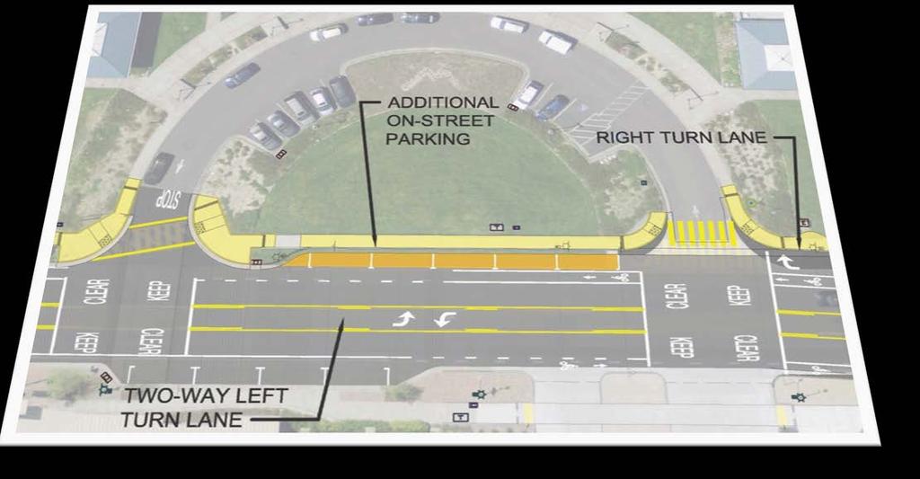
11 Windsor Rd/Windsor River Rd Roundabout Option Windsor Rd/Windsor River Rd Traffic Signal Option Page 6 of 13


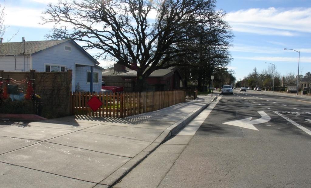
12 Starr Road Sidewalk Gap Closure New Sidewalk Proposed Sidewalk Page 7 of 13


13 New Sidewalk Windsor Road Sidewalk Gap Closure Page 8 of 13


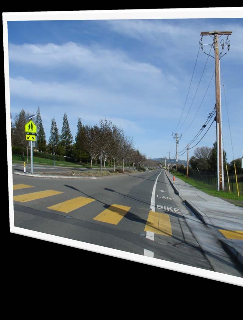
14 Keiser Park/Starr Creek Trail Extension Keiser Park Existing Trail Existing Path Existing Trail Windsor High School Page 9 of 13


15 Windsor Safe Routes to School Program Downtown Bicycle Pedestrian Crossing of US 101 Study Jaguar Way Concept Plan Page 10 of 13

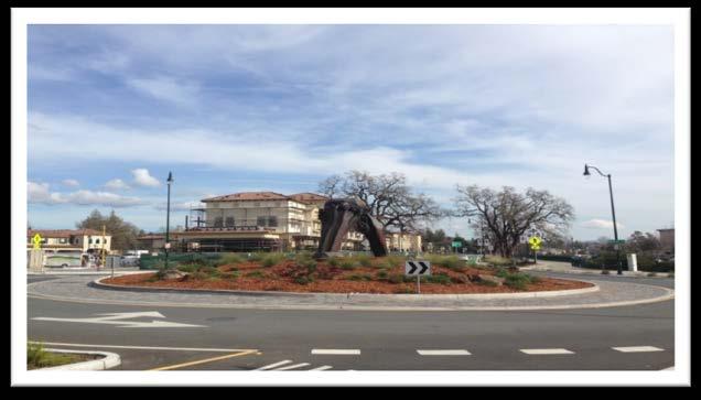
16 Old Redwood Highway Road Improvements at Bell Village Page 11 of 13


17 Windsor Mill Project Windsor Creek Elementary Bell Rd Windsor Mill Project Page 12 of 13


18 Page 13 of 13
TOWN OF WINDSOR AGENDA REPORT
 ITEM NO. : 9.7 Town Council Meeting Date: June 17, 2015 TOWN OF WINDSOR AGENDA REPORT To: From: Subject: Mayor and Town Council Jim O Brien, Project Manager Approve a Professional Services Agreement for
Preliminary Engineering Study
 Preliminary Engineering Study Open House # 2 June 6, 2018 PREPARED FOR: PREPARED BY: Agenda Background and status of preliminary engineering study County Road 26 design summary County Road 63 design summary
VIII. Project Prioritization & Implementation
 Transportation Plan 2030 July 2006 VIII. Project Prioritization & Implementation Public Transit Service Investigation into the development of a demand responsive service route system through a process
City of Sammamish. Welcome. Issaquah-Fall City Road Improvements Project Phase I Design: 242nd Avenue SE to Klahanie Drive SE
 Welcome Welcome to the third community meeting for the Issaquah-Fall City Road Improvements Project. AGENDA 6:00 p.m. Welcome and sign-in 6:10 p.m. Presentation 6:50 p.m. Open house Learn about the roadway
Brooklyn Boulevard (County Road 152) Reconstruction Project Phase I. OPEN HOUSE June 20, 2017
 Reconstruction Project Phase I. OPEN HOUSE June 20, 2017") Brooklyn Boulevard (County Road 152) Reconstruction Project Phase I OPEN HOUSE June 20, 2017 Brooklyn Boulevard (County Road 152) Phase I Project Partners Project Lead Other Project Partners include Brooklyn
Brooklyn Boulevard (County Road 152) Reconstruction Project Phase I OPEN HOUSE June 20, 2017 Brooklyn Boulevard (County Road 152) Phase I Project Partners Project Lead Other Project Partners include Brooklyn
February 2018 HIGHWAY 316 IMPROVEMENTS PROJECT
 February 2018 HIGHWAY 316 IMPROVEMENTS PROJECT Agenda 1 2 3 4 5 A Message from the City Project Area Traffic Conditions Pedestrian/Bicycle Comfort & Safety Next Steps Q&A City of Hastings Supports a study
City of Charlottesville Bicycle and Pedestrian Master Plan Update
 City of Charlottesville Bicycle and Pedestrian Master Plan Update September 17, 2014 I. Welcome and meeting overview II. Project status update III. Network overview IV. Break-out groups Pedestrian Network
Traffic and Flood Control Improvements in the Transit Oriented Development District Project Updates Tuesday, November 29, 2016 Meriden Public Library
 Traffic and Flood Control Improvements in the Transit Oriented Development District Project Updates Tuesday, November 29, 2016 Meriden Public Library Presentation Format Project Goals and Overview Sidewalk
TABLE OF CONTENTS. Executive Summary
 Executive Summary Background... ES-1 Pedestrian Network... ES-2 Bikeway Network... ES-2 Collision History... ES-2 Public Input... ES-4 Conclusions and Recommendations... ES-4 1. Introduction and Setting
TOWN OF MORAGA MORAGA WAY AND CAMINO PABLO/CANYON ROAD IMPROVEMENTS Town Council Meeting March 13, 2019
 TOWN OF MORAGA MORAGA WAY AND CAMINO PABLO/CANYON ROAD IMPROVEMENTS Town Council Meeting March 13, 2019 1 Edric Kwan, Public Works Director Josh Peterman, Principal, Fehr and Peers Shawn Knapp, Senior
Phone: Fax: Project Reference No. (to be filled out by MassHighway):
:") Massachusetts Highway Department District 3 Project Need Form (PNF) This form is intended to provide preliminary information about the proposed project. It is not expected that all information that is
Massachusetts Highway Department District 3 Project Need Form (PNF) This form is intended to provide preliminary information about the proposed project. It is not expected that all information that is
Route 29 Corridor Assessment Update. Development of Possible Solutions
 Route 29 Corridor Assessment Update Development of Possible Solutions Public Workshop #3 October 27, 2016 Purpose of Developing Possible Solutions Recap of where we ve been and timeline for moving forward
CITY OF LANCASTER PROPOSED NEW PROJECTS
 CITY OF LANCASTER 2013-2014 PROPOSED NEW PROJECTS Project Code 11 Facilities and Fixtures Project Title 1 11BS018 Main. Yard Storage Bldg, Phase 2 2 11GS007 Parks Improvements 3 11GS008 Dog Park AHP 4
Action Recommendation: Budget Impact:
 City of Fayetteville Staff Review Form Submitted By 2018 0473 Legistar File ID 9/18/2018 City Council Meeting Date Agenda Item Only N/A for Non Agenda Item Matt Mihalevich 8/28/2018 DEVELOPMENT SERVICES
Application of a Complete Street
 Application of a Complete Street Southbend to Prima Vista Update May 14, 2018 Meeting Agenda Perspective and History Public input received Typical sections being considered Presentation of the 2-lane master
MASTER BICYCLE AND PEDESTRIAN PLAN
 VILLAGE OF NORTHBROOK MASTER BICYCLE AND PEDESTRIAN PLAN DRAFT PLAN OPEN HOUSE May 2, 2018 AGENDA 1. Community Engagement 2. Vision and Goals 3. General Structure of Plan 4. Recommendations Overview 5.
Fairfax County Parkway Widening Fairfax County
 Get Involved VDOT representatives will review and evaluate information received as a result of this meeting. Please fill out the comment sheet provided in this brochure if you have any comments or questions.
Bicycle Pedestrian Master Plan Pre Bid Meeting Portsmouth, NH August 15, 2013
 Bicycle Pedestrian Master Plan Pre Bid Meeting Portsmouth, NH August 15, 2013 2005 Master Plan GOAL: Provide for safe and convenient bicycle and pedestrian circulation throughout the City. Develop a city
BOARD OF COUNTY COMMISSIONERS AGENDA ITEM SUMMARY
 7B BOARD OF COUNTY COMMISSIONERS AGENDA ITEM SUMMARY PLACEMENT: REQUESTS AND PRESENTATIONS PRESET: TITLE: FLORIDA DEPARTMENT OF TRANSPORTATION (FDOT) PRESENTATION RECONSTRUCTION OF SR-76 (SW KANNER HIGHWAY)
Lynchburg District Update
 Lynchburg District Update Virginia Statewide Bicycle and Pedestrian Advisory Committee Spring Meeting May 16 th, 2017 David Cook Transportation Planner, VDOT Lynchburg District Table of Contents Active
PROJECT FACT SHEET May 25, 2018
 SITE CHALLENGES & PROJECT BACKGROUND In 2014, the City of Aspen identified the Castle Creek Bridge and Hallam Street corridor as a deficient link in Aspen s bicycle and pedestrian network. Safe and efficient
FDOT Bicycle/Pedestrian Focused Initiative & Complete Streets
 Florida Department of TRANSPORTATION FDOT Bicycle/Pedestrian Focused Initiative & Complete Streets Billy L. Hattaway, PE District One Secretary Secretary s Pedestrian Safety Initiative Dangerous by Design
Non-Motorized Transportation 7-1
 Non-Motorized Transportation 7-1 Transportation facilities no longer mean just accommodating a vehicle powered by a combustion engine. Pedestrian and non-motorized facilities are important modes of travel
Route 245 over Broad Run. The recently replaced bridge links The Plains and other communities in northern Fauquier to Interstate 66.
 28 VIRGINIA DEPARTMENT OF TRANSPORTATION \\ CULPEPER DISTRICT Route 245 over Broad Run. The recently replaced bridge links The Plains and other communities in northern Fauquier to Interstate 66. PROJECT
OTO BIKE/PED PLAN REPORT
 OTO BIKE/PED PLAN REPORT 6/30/2012 Implementation in FY2012 This report outlines the bike/ped accomplishments related to the OTO Bike/Ped Plan. Activities occurring during the 2012 Fiscal Year, July 1,
10A. DATE: October 5, Pedestrian and Bicycle Advisory Committee. Kevin Colin, Deputy Planning Manager Curt Bates, City Engineer
 10A DATE: October 5, 2016 TO: PREPARED BY: SUBJECT: Pedestrian and Bicycle Advisory Committee Kevin Colin, Deputy Planning Manager Curt Bates, City Engineer Discussion and Provide Comments, Associated
Chapter 3.6 Elementary School Z. Volusia County MPO. March Page 13.0
 Chapter 3.6 Elementary School Z DeLand, FL Volusia County MPO March 2008 Page 13.0 Volusia County MPO Bicycle and Pedestrian School Safety Review Study Introduction Elementary School Z is a planned elementary
CITY OF PORTSMOUTH PLANNING DEPARTMENT
 CITY OF PORTSMOUTH PLANNING DEPARTMENT MEMORANDUM TO: JOHN P. BOHENKO, CITY MANAGER FROM: JULIET T.H. WALKER, PLANNING DIRECTOR SUBJECT: BICYCLE / PEDESTRIAN PLAN PROGRESS UPDATE DATE: 3/13/2018 Background
Los Altos Hills Town Council - June 18, 2015 Palo Alto City Council June 22, AGENDA ITEM #2.B Presentation
 Los Altos Hills Town Council - June 18, 2015 Palo Alto City Council June 22, 2015 AGENDA ITEM #2.B Presentation Previous Presentations Los Altos Hills Town Council in May 2014 and February 2015 Palo Alto
HOOPA DESIGN FAIR 4. IMPLEMENTATION PHASES & FUNDING
 4. IMPLEMENTATION PHASES & FUNDING HOOPA DESIGN FAIR 4-1 4. IMPLEMENTATION PHASES & FUNDING Phase One Development 1. Implementation The Conceptual Plan recommends five concept elements to revitalize downtown
CITY MANUALS AND STANDARDS REVIEW
 GEORGETOWN SIDEWALK MASTER PLAN CITY MANUALS AND STANDARDS REVIEW RESOURCES AND STANDARDS As part of the Master Plan process, a review and evaluation of current City documents and policies relevant to
Issues, Opportunities, and Enhancement Strategies. Evaluation Team: Debbie Yueh, AICP Bruce S. Appleyard, PhD, AICP. August 2012
 UNIVERSITY OF CALIFORNIA, BERKELEY INSTITUTE OF TRANSPORTATION STUDIES TECHNOLOGY TRANSFER PROGRAM 20020 TOWN OF WINDSOR PEDESTRIAN SAFETY ASSESSMENT Issues, Opportunities, and Enhancement Strategies Evaluation
Bicycle and Pedestrian Advisory Committee (BPAC) November 21, 2013
 November 21, 2013") Bicycle and Pedestrian Advisory Committee (BPAC) November 21, 2013 OVERALL LAND USE CONCEPT Overall Broadway Valdez District: 95.5 acres (35.1 acres right-of ways + 60.4 acres developable land) Plan Subareas:
Bicycle and Pedestrian Advisory Committee (BPAC) November 21, 2013 OVERALL LAND USE CONCEPT Overall Broadway Valdez District: 95.5 acres (35.1 acres right-of ways + 60.4 acres developable land) Plan Subareas:
Mineral Avenue Corridor Assessment. ITE 2017 Western District Annual Meeting San Diego, CA June 21 st
 Mineral Avenue Corridor Assessment ITE 2017 Western District Annual Meeting San Diego, CA June 21 st Biography - Aaron Heumann, PE, PTOE Currently City of Littleton Transportation Engineering Manager 24
Rolling Out New Bike Facilities Within the North Bethesda & White Flint Area
 Rolling Out New Bike Facilities Within the North Bethesda & White Flint Area Rolling Out New Bike Facilities Within the North Bethesda & White Flint Area Agenda Designing for all Cyclists Background on
WELCOME. Stakeholder Involvement Group Meeting #2 Round Lake Public Works October 24, 2018
 WELCOME Stakeholder Involvement Group Meeting #2 Round Lake Public Works October 24, 2018 MEETING AGENDA 1. Welcome and Introductions 2. Study Progress Update 3. Problem Statement 4. Technical Analysis
Southbend to Prima Vista. October 30, Floresta Corridor Master Plan
 Application of a Complete Street initiative and how it might function operationally 8 8 Southbend to Prima Vista October 30, 2017 Presentation Agenda 2 Perspective and History Traffic projections, Levels
Bicycle and Pedestrian Connectivity Study Phase 2
 Connectivity Study Phase 2 Process PROCESS OUTCOMES Phase Prepared By STEP I Public Participation and Outreach 1. RTP Outreach activities, and development of the Bike and Ped Task Force Phase 1 2011 OCPC
TRANSPORTATION & MOBILITY
 TRANSPORTATION & MOBILITY ROADWAY SYSTEM There are approximately 40 miles of roadways in Manitou Springs. For planning purposes, roadways are typically assigned a functional classification which defines
Bicycle Pedestrian Commission
 City of Gilroy Bicycle Pedestrian Commission Strategic Plan 2017 Table of Contents Invitation to the Public Goals Action Plan Grants Bicycle/Pedestrian Projects 2 3-4 5-6 7 8-9 1 The Bicycle Pedestrian
San Jose Transportation Policy
 San Jose Transportation Policy Protected Intersections in LOS Policies to Support Smart Growth Presented by: Manuel Pineda City of San Jose Department of Transportation Bay Area Map San Francisco Oakland
Traffic Improvements for the Transit Oriented Development District (TODD) Meriden Public Library March 11, 2014
 Meriden Public Library March 11, 2014") Traffic Improvements for the Transit Oriented Development District (TODD) Meriden Public Library March 11, 2014 Project Overview Coordinate roadway improvements with other major projects HUB Flood Control
Traffic Improvements for the Transit Oriented Development District (TODD) Meriden Public Library March 11, 2014 Project Overview Coordinate roadway improvements with other major projects HUB Flood Control
MONTGOMERY COUNTY COUNCIL MEMORANDUM
 MONTGOMERY COUNTY COUNCIL R O C K V I L L E, M A R Y L A N D HANS RIEMER COUNCILMEMBER AT-LARGE MEMORANDUM To: T&E Committee From: Councilmember Hans Riemer Date: March 1, 2016 Re: Funding a Protected
Pine Hills Road Pedestrian/Bicycle Safety Study Board of County Commissioners Work Session
 Pine Hills Road Pedestrian/Bicycle Safety Study Board of County Commissioners Work Session February 20, 2018 Meeting Agenda Study Overview Existing Conditions Access Management Potential Gateway Features
GARLAND ROAD/GASTON AVENUE/ GRAND AVENUE INTERSECTION IMPROVEMENT STUDY
 MEETING OF AFFECTED PROPERTY OWNERS AND STAKEHOLDERS GARLAND ROAD/GASTON AVENUE/ GRAND AVENUE INTERSECTION IMPROVEMENT STUDY CSJ 0009-02-067 Meeting Agenda 1 2 3 4 5 6 7 8 9 10 Opening Remarks State Representative
Work Session. Agenda Item # 4. Meeting Date September 8, Daryl Braithwaite Public Works Director. Prepared By. Suzanne R. Ludlow City Manager
 Agenda Item # 4 Work Session Meeting Date September 8, 2015 Prepared By Approved By Daryl Braithwaite Public Works Director Suzanne R. Ludlow City Manager Discussion Item Background Temporary Neighborhood
Highway 56 Traffic Study Rymal Road to Cemetery Road
 January 31, 2018 6:00 pm 8:00 pm Highway 56 Traffic Study Rymal Road to Cemetery Road City of Hamilton Public Meeting 2 2 Purpose of Public Meeting To review and obtain public input and comments on the
Trans-Canada Highway 1 RW Bruhn Bridge Replacement
 Trans-Canada Highway 1 RW Bruhn Bridge Replacement May 2016 RW Bruhn Bridge Project Objectives Improve safety, traffic flow and movement of goods Improve safety for pedestrians and cyclists Replace the
PROJECT OBJECTIVES. Improve vehicle capacity for the intersection. Improve pedestrian and bicycle access
 COMMUNITY MEETING Project Update March 15, 2010 Purcellville, Virginia OVERVIEW Project need / objectives Project recap Design elements Proposed improvements Summary of project benefits / next steps PROJECT
SR-203 Sidewalks and Town-Wide Mobility Improvements. Town Council Presentation September 7, 2016
 SR-203 Sidewalks and Town-Wide Mobility Improvements Town Council Presentation September 7, 2016 SR-203 Sidewalks and Town- Wide Mobility Improvements SR-203 Sidewalks and Appurtenances Town-Wide Mobility
SC 41/Joe Rouse Intersection Improvements
 SC 41/Joe Rouse Intersection Improvements Scope: Add dual left-turn lanes from Joe Rouse Road onto southbound SC 41 to reduce re-occurring peak hour congestion, particularly the AM peak. Construction Cost
Legislative Update Williamsburg Residency
 Hampton Roads District Legislative Update Williamsburg Residency Jim Brewer, Resident Administrator 757-253-5140 Projects Under Way Warwick Boulevard Project http://www.warwickboulevard.org/ Contractors:
Southwest Bus Rapid Transit (SW BRT) Functional Planning Study - Executive Summary January 19 LPT ATTACHMENT 2.
 Functional Planning Study - Executive Summary January 19 LPT ATTACHMENT 2.") Southwest Bus Rapid Transit (SW BRT) Functional Planning Study - Executive Summary 2011 January 19 1 of 19 Introduction This executive summary presents the results of the Southwest Bus Rapid Transit (SW
Southwest Bus Rapid Transit (SW BRT) Functional Planning Study - Executive Summary 2011 January 19 1 of 19 Introduction This executive summary presents the results of the Southwest Bus Rapid Transit (SW
TOWN OF MORAGA. CAMINO PABLO & CANYON ROAD INTERSECTION IMPROVEMENTS Public Information Meeting February 20, 2019
 TOWN OF MORAGA CAMINO PABLO & CANYON ROAD INTERSECTION IMPROVEMENTS Public Information Meeting February 20, 2019 Edric Kwan, Public Works Director April Malvino Miller, BKF Project Design Manager Shawn
Giles Run Connector Road
 Giles Run Connector Road Laurel Hill Adaptive Reuse Area to Laurel Crest Drive South County Federation Meeting June 14, 2016 History Connector road included in the Laurel Hill Comprehensive Plan amendment
PROJECT FACT SHEET March 21, 2018
 SITE CHALLENGES & PROJECT BACKGROUND In 2014, the City of Aspen identified the Castle Creek Bridge and Hallam Street corridor as a deficient link in Aspen s bicycle and pedestrian network. Safe and efficient
5 CIRCULATION AND STREET DESIGN
 5 CIRCULATION AND STREET DESIGN This chapter describes circulation and streetscape improvements proposed for the Northwest Chico Specific Plan Area. It includes detailed design specifications for existing
TO: Board Members Vancouver Park Board FROM: General Manager Parks and Recreation SUBJECT: Seaside Greenway Improvements
 Date: October 1, 2013 TO: Board Members Vancouver Park Board FROM: General Manager Parks and Recreation SUBJECT: Seaside Greenway Improvements RECOMMENDATION A. THAT the Board approve the new bike paths
ARLINGTON COUNTY, VIRGINIA
 ARLINGTON COUNTY, VIRGINIA County Board Agenda Item Meeting of October 15, 2016 DATE: October 7, 2016 SUBJECT: Adoption of amendments to the Master Transportation Plan (MTP) to create a new Pedestrian
Legislative Update. Frederick County Fall Staunton District. Interstate 81 - Exit 300 at Interstate 66 Southbound Acceleration Lane Extension
 Interstate 81 - Exit 300 at Interstate 66 Southbound Acceleration Lane Extension Application ID 1643 Northern Shenandoah Valley Regional Commission (NSVRC) $3,437,423 This project extends the Interstate
HARRISON STREET/OAKLAND AVENUE COMMUNITY TRANSPORTATION PLAN
 HARRISON STREET/OAKLAND AVENUE Community Workshop #4: Draft Plan Review December 3, 2009 D E S I G N, C O M M U N I T Y & E N V I R O N M E N T INTRODUCTIONS Key Project Staff: Alisa Shen, Project Manager,
Municipal Class EA To Address Traffic Congestion On The Ontario Street Corridor (Grand Bend) Public Information Meeting June 4, 2018
 Public Information Meeting June 4, 2018") Municipal Class EA To Address Traffic Congestion On The Ontario Street Corridor (Grand Bend) Public Information Meeting June 4, 2018 Background Agenda Traffic Study Update Class EA Alternatives Bridge
Municipal Class EA To Address Traffic Congestion On The Ontario Street Corridor (Grand Bend) Public Information Meeting June 4, 2018 Background Agenda Traffic Study Update Class EA Alternatives Bridge
Community Transportation Plan
 Community Transportation Plan Appendix A: Traffic Calming CITY OF DECATUR COMMUNITY TRANSPORTATION PLAN Appendix A: City of Decatur City-wide Residential Traffic Calming Program Process & Procedures The
Intersection Control Evaluation Report Project: Alternative: Location: Evaluator:
 Report Project: Alternative: Location: Evaluator: Franklin/Interstate-15 Interchange City of Lake Elsinore, 33 40'13.08"N 117 18'34.30"W Jeffrey Hsu 1 Introduction Policy Directive 13-02 calls for the
Advancing Transportation Choices in Des Moines. MPO Environmental Roundtable January 9, 2018
 Advancing Transportation Choices in Des Moines MPO Environmental Roundtable January 9, 2018 Presented by Jennifer McCoy, PE, PTOE City Traffic Engineer Agenda Des Moines Area Transportation Planning Connect
NJDOT Complete Streets Checklist
 Background The New Jersey Department of Transportation s Complete Streets Policy promotes a comprehensive, integrated, connected multi-modal network by providing connections to bicycling and walking trip
CITY OF SIGNAL HILL Cherry Avenue Signal Hill, CA
 CITY OF SIGNAL HILL 2175 Cherry Avenue Signal Hill, CA 90755-3799 AGENDA ITEM TO: HONORABLE MAYOR AND MEMBERS OF THE CITY COUNCIL FROM: STEVE MYRTER, P. E. DIRECTOR OF PUBLIC WORKS SUBJECT: SPRING STREET
PREFERRED ALTERNATIVE IMPLEMENTATION PLAN. Prepared for. Ohio Department of Transportation, District South SR 741 Lebanon, Ohio 45036
 HAM-32F-0.00 PID 86461 PREFERRED ALTERNATIVE IMPLEMENTATION PLAN Prepared for Ohio Department of Transportation, District 8 505 South SR 741 Lebanon, Ohio 45036 Prepared by URS Corporation 564 White Pond
West Circle Drive (CSAH 22) Traffic Operations Study
 Traffic Operations Study") West Circle Drive (CSAH 22) Traffic Operations Study May 24, 2016 Open House Harriet Bishop Elementary School 6:45 8:00 p.m. Presentation at 7:00 p.m. Purpose of Tonight s Meeting Introductions Explain
West Circle Drive (CSAH 22) Traffic Operations Study May 24, 2016 Open House Harriet Bishop Elementary School 6:45 8:00 p.m. Presentation at 7:00 p.m. Purpose of Tonight s Meeting Introductions Explain
Stakeholder Update. Agenda. Project update Needs Identification Strategy Proposed needs Safety Collectors/Arterials Greenways Local roads
 1 Stakeholder Update May 21, 2018 2 Agenda Project update Needs Identification Strategy Proposed needs Safety Collectors/Arterials Greenways Local roads Proposed Evaluation Criteria Next Steps 1 Project/Schedule
Safe Routes to School Action Plan Aberdeen, Idaho
 Background Aberdeen, Idaho is a largely agricultural community of nearly 2,000 people and is located in the southeast portion of the state on the western edge of American Falls Reservoir. The community
Houma-Thibodaux Metropolitan Planning Organization STP<200K Funding Application APPLICATION
 APPLICATION HOUMA-THIBODAUX METROPOLITAN PLANNING ORGANIZATION (HTMPO) FOR SURFACE TRANSPORTATION PROGRAM (STP
AGENDA REPORT. Issue: Discussion of potential improvements on Barnwell Road at Niblick Drive
 AGENDA REPORT To: From: By: Honorable Mayor and City Council Members Warren Hutmacher, City Manager Tom Black, Public Works Director Date: March 23, 2016 Agenda: March 28, 2016 WORK SESSION AGENDA: Barnwell
Public Information Meeting. Warren County Pathway Corridor Project September 27, 2018
 Public Information Meeting Warren County Pathway Corridor Project September 27, 2018 Why are we here? Introduce Study Hear concerns and Ideas Obtain input on preliminary Alternatives Previous Study (2008)
Public Information Meeting. Orange Camp Road. Dr. Martin Luther King Jr. Beltway to I-4. Presented by: Volusia County August 2, 2018
 Public Information Meeting Orange Camp Road Dr. Martin Luther King Jr. Beltway to I-4 Presented by: Volusia County August 2, 2018 1 Project Goals To improve the operations and safety for Orange Camp Road
1 st and 2 nd Street Couplet FAQ s
 1 st and 2 nd Street Couplet FAQ s Q. Will the proposed roundabout at Flume/2nd/1 st Streets affect access to businesses nearby?... 2 Q. What if the project isn t received well by the community after construction?...
ROUTE 81 CORRIDOR STUDY DESIGN CONCEPTS
 RT 81 Corridor Study CLINTON ROUTE 81 CORRIDOR STUDY DESIGN CONCEPTS View north on High Street, with potential improvements to the streetscape Draft Recommendations November 8 th, 2018 TOWN OF CLINTON
SOLANA BEACH BICYCLE TRANSPORTATION PLAN SECOND ADDENDUM
 SOLANA BEACH BICYCLE TRANSPORTATION PLAN SECOND ADDENDUM Prepared by the City of Solana Beach January 2005 Introduction In June of 1993, the Solana Beach City Council adopted a Bikeway Master Plan as directed
Board of Supervisors February 27, 2017
 : Traffic Analysis Results & Draft Conceptual Plan Board of Supervisors February 27, 2017 Transportation Solutions Building Better Communities Presentation Overview Background Summary of Traffic Analysis
1609 E. FRANKLIN STREET HOTEL TRAFFIC IMPACT STUDY EXECUTIVE SUMMARY
 1609 E. FRANKLIN STREET HOTEL TRAFFIC IMPACT STUDY EXECUTIVE SUMMARY Prepared for: The Town of Chapel Hill Public Works Department Traffic Engineering Division Prepared by: HNTB North Carolina, PC 343
Hennepin Avenue Reconstruction Washington Avenue to 12 th Street
 CITY OF MINNEAPOLIS Hennepin Avenue Reconstruction Washington Avenue to 12 th Street April 2016 1 Upcoming Opportunities Public Meeting #2 April 25, 2016 Minneapolis Central Library Doty Board Room Repeat
Diamond Springs Parkway Project
 Diamond Springs Parkway Project Public Information Meeting, Monday, March 18, 2013 330 Fair Lane, Building A, Placerville County Board of Supervisors Meeting Room, 6:30 8:00 p.m. PRESENTED BY: County of
BICYCLE AND TRAILS ADVISORY COMMISSION Meeting Minutes
 Minutes Approved as Submitted Date: 8/10/17 Initials: EC BICYCLE AND TRAILS ADVISORY COMMISSION Meeting Minutes June 8, 2017 The Bicycle and Trails Advisory Commission was called to order at 4:00 p.m.
West Capitol Avenue Road Rehabilitation and Safety Enhancement Project
 West Capitol Avenue Road Rehabilitation and Safety Enhancement Project Stakeholder Focus Group Meeting #2 Tuesday, August 28, 2018 7:00 8:00 a.m. West Sacramento City Hall 1110 West Capitol Avenue, West
Central Avenue Corridor Study FPID Number:
 Central Avenue Corridor Study FPID Number: 437932-1-18-01 City Commission Presentation 1 March 27, 2018 Meeting Agenda 1. Introductions 2. Project Overview 3. Opportunity for Economic Development 4. Healthy
Santa Clara County Expressways Complete Streets & Design Challenges
 Santa Clara County Expressways Complete Streets & Design Challenges Presented as part of County Partnerships to Improve Community Health Project Panel Discussion September 24, 2015 By Dan Collen, Deputy
Paoli Road Improvement Feasibility Study
 Paoli Road Improvement Feasibility Study & Public Participation Project March 24, 2015 Prepared for: Tredyffrin Township Prepared by: McMahon Associates, Inc. with Town Planning Partnership, LLC Glackin
Commerce Street Complete Street Project from Good Latimer Expressway to Exposition Avenue
 Commerce Street Complete Street Project from Good Latimer Expressway to Exposition Avenue T A N Y A B R O O K S A S S I S T A N T D I R E C T O R M O B I L I T Y P L A N N I N G M O B I L I T Y A N D S
APPENDIX L: COST ESTIMATING TOOLS
 APPENDIX L: COST ESTIMATING TOOLS Rural Arterial From LRE MOT * Mobilization * Subtotal Scope Contingency (25%) Total PE Design (15%) CEI (15%) Total Project ** New (2-Lane Roadway) with 5' Paved Shoulders
Route 79/Davol Street Corridor Study
 Route 79/Davol Street Corridor Study Fall River, MA Public Information Meeting #2 November 21, 2013 Fall River Heritage State Park Fall River, MA Agenda Welcome and Introductions Overview of Study Process
Bicycle Count Data. December 2008
 Bicycle Count Data December 28 Published By: San Luis Obispo Public Works Department 919 Palm Street, San Luis Obispo, California 9341 Telephone (85) 781 719; FAX (85) 781 7198 www.slocity.org Introduction
SECTION TRAFFIC REGULATIONS
 SECTION 01550 TRAFFIC REGULATIONS PART 1 - GENERAL 1.01 OBJECTIVES A. The Contractor shall provide for safe movement of vehicular, bicycle and pedestrian traffic, including persons with disabilities in
DEKALB COUNTY. 22. Priority Projects for DeKalb County
 DEKALB COUNTY 2 0 1 4 T R A N S P O R T A T I O N P L A N 22. Priority s for DeKalb County Following the completion of the project prioritization metrics, each project was able to be compared to other
CITY OF KASSON TRANSPORTATION ALTERNATIVES KASSON SAFE ROUTES TO SCHOOL
 ve ha 8t G B A Mantorville Ave N 240th Ave 16th St NE 11th Ave NE K-M HIGH SCHOOL SUNRISE TRAIL TO MANTORVILLE MNTH 57 SUNSET TRAIL TO MANTORVILLE NE PARK 16TH ST NE TRAIL K-M ELEMENTARY SCHOOL K-M MIDDLE
Culpeper District. Albemarle County Monthly Report October, 2011
 Culpeper District Albemarle County Monthly Report Special Issues FY2013 Revenue Sharing Program - If you wish to participate in the Revenue Sharing Program for the fiscal year starting July 1, 2012, applications
2011 Capital Projects University Area - Community Council Priority List Municipality of Anchorage
 2011 Capital Projects University Area - Community Council Priority List Municipality of Anchorage 2 Project Management and Engineering Projects on 40th Ave Extension - Lake Otis Pkwy to Dale St $18,103,000
RZC Appendix 8A Marymoor Subarea Street Requirements
 RZC Appendix 8A Marymoor Subarea Street Requirements For additional design details for Marymoor Subarea infrastructure, refer to the 2017 Marymoor Subarea Infrastructure Planning Report. STREET REQUIREMENTS
Access Management Regulations and Standards
 Access Management Regulations and Standards January 2014 Efficient highway operation Reasonable property access Concept of Access Management The way to manage access to land development while preserving
Building Great Neighbourhoods BONNIE DOON
 Building Great Neighbourhoods BONNIE DOON We Are Here Today To Explain the Neighbourhood Renewal Process Show you the Westwood Preliminary Design Ask for local knowledge Highlight the Local Improvement
Attached for your reference please find project updates on ongoing VDOT construction projects in Southampton County.
 SOUTHAMPTON COUNTY BOARD OF SUPERVISORS Regular Session i July 25, 2016 6. HIGHWAY MATTERS A. PLAN PROJECT UPDATES Attached for your reference please find project updates on ongoing VDOT construction projects