PLAN 20 PUBLIC TRANSPORT NETWORK
|
|
|
- Brice Hicks
- 6 years ago
- Views:
Transcription


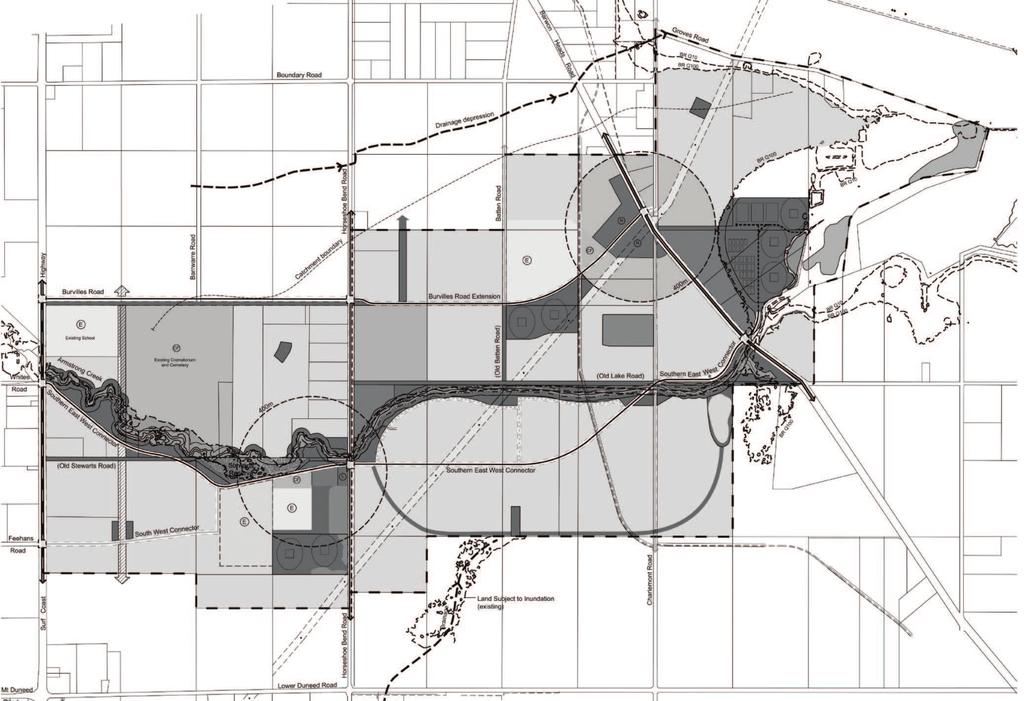
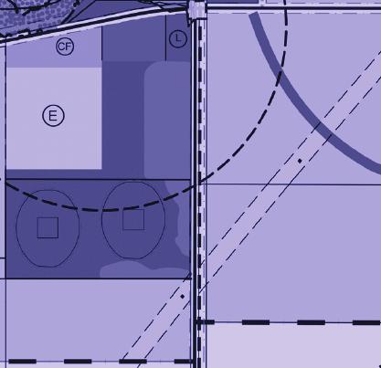
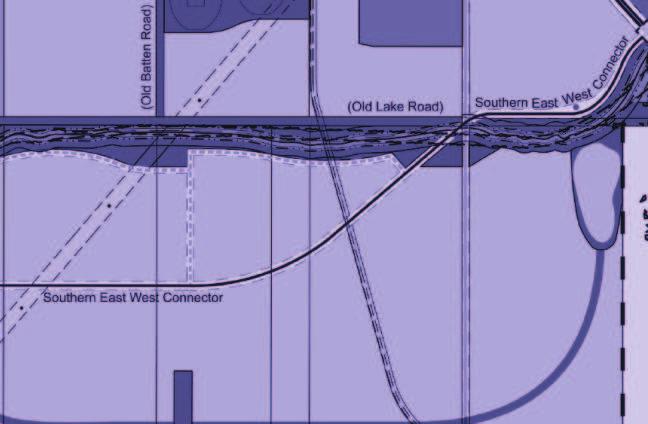
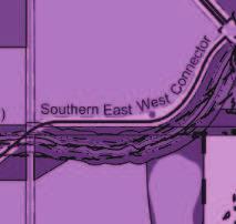


1 KEY Bus Route / 400m Coverage Existing Recommended Secondary Potential Secondary Indicative Stop Locations Principle Standard Sub-regional Transit Corridor Reservation PLAN 0 PUBLIC TRANSPORT NETWORK Date: 11 January 010
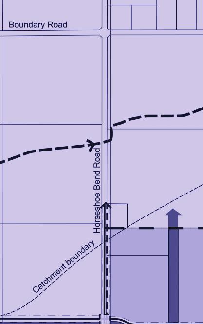
2 Table 8: Road Design Characteristics Category (refer Section 5.1.1) Related Cross Section in ACEPSP Road / Street Existing Reserve (metres) Ultimate Reserve (metres) Access Management Policy Indicative Vehicles per Day (VPD - maximum) Traffic Lanes Dedicated Parking Lanes Median Speed Limit (Maximum) Bus Compatible Property Access On Road Cycle Lane Shared Path (.5 metres) Footpath (1.5 metres) Construction Responsibility * Funding Responsibility Trigger for construction A NA Surf Coast Highway (land and construction) NA Surf Coast Highway intersection with Burvilles Road NA Surf Coast Highway intersection with southern East-West Connector NA Surf Coast Highway intersection with South West Connector A NA Barwon Heads Road (land and construction) NA Barwon Heads Road intersection with Burvilles Road extension * AMP *** 5, Yes 80 yes no Yes x No As required Roads Corporation NA NA NA NA NA NA NA NA NA NA NA NA NA Roads Corporation NA NA NA NA NA NA NA NA NA NA NA NA NA Roads Corporation NA NA NA NA NA NA NA NA NA NA NA NA NA Roads Corporation * AMP *** 9,000 (through ACEP) 4 0 Yes 80 Yes No Yes x No As required Roads Corporation NA NA NA NA NA NA NA NA NA NA NA NA NA Roads Corporation Roads Corporation Major activity centre precinct DCP (50:50 split with Armstrong Creek West Precinct) DCP (50:50 split with Armstrong Creek West Precinct) Roads Corporation Developer for type C intersection; DCP for signalisation of single carriageway; Roads Corporation for duplicated carriageway As required As required for major activity centre Before opening of fourth leg on intersection Before opening of fourth leg on intersection As required As required but signalisation before opening of fourth road leg of intersection O:\projects\ \004\word\working\W _00010 Collie Lodged Copy of ACEPSP with tracked changes.doco:\projects\ \004\word\working\w _10110 Collie Lodged Copy of ACEPSP with tracked changes.doco:\projects\ \004\word\working\w _ Collie Lodged Copy of ACEPSP.doc 10
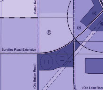
3 Category (refer Section 5.1.1) Related Cross Section in ACEPSP Road / Street Existing Reserve (metres) Ultimate Reserve (metres) Access Management Policy Indicative Vehicles per Day (VPD - maximum) Traffic Lanes Dedicated Parking Lanes Median Speed Limit (Maximum) Bus Compatible Property Access On Road Cycle Lane Shared Path (.5 metres) Footpath (1.5 metres) Construction Responsibility * Funding Responsibility Trigger for construction NA Barwon Heads Road intersection with southern East-West Connector) B Figure F Burvilles Road Interim (east boundary of Geelong Memorial Park to Horseshoe Bend Road) B C Figure G Figure H Burvilles Road Ultimate (east boundary of Geelong Memorial Park to Horseshoe Bend Road) Burvilles Road Extension (land and construction) (Horseshoe Bend Road to Barwon Heads Road) B Figure I Horseshoe Bend Road Interim NA NA NA NA NA NA NA NA NA NA NA NA NA Roads Corporation 0 43 (3 road; 0 greenway) 0 43 (3 road; 0 greenway) NA 10,400 No 60 Yes Yes - north side only NA 10, No 60 Yes Yes - north side only NA 4 NA 6,500 No 60 Yes Yes Yes x NA 11,300 0 No 60 Yes Yes (west side only) Yes x Yes x Yes x Yes in 'gree nway' Yes in 'gree nway' Developer for type C intersection; DCP for signalisation of single carriageway; Roads Corporation for signalisation of duplicated carriageway Yes x 1 Developer DCP (50:50 split of land with Horseshoe Bend Precinct); developer (share of construction) As required but signalisation before opening of fourth road leg ofof intersection As abutting Yes x 1 CoGG CoGG As required Yes Yes x 1 Developer DCP (only cost of pavement wider than typical local access street); developer for remainder and any overall costs above DCP payments No Yes x Developer DCP (land only); developer As abutting As abutting O:\projects\ \004\word\working\W _00010 Collie Lodged Copy of ACEPSP with tracked changes.doco:\projects\ \004\word\working\w _10110 Collie Lodged Copy of ACEPSP with tracked changes.doco:\projects\ \004\word\working\w _ Collie Lodged Copy of ACEPSP.doc 103
4 Category (refer Section 5.1.1) Related Cross Section in ACEPSP Road / Street Existing Reserve (metres) Ultimate Reserve (metres) Access Management Policy Indicative Vehicles per Day (VPD - maximum) Traffic Lanes Dedicated Parking Lanes Median Speed Limit (Maximum) Bus Compatible Property Access On Road Cycle Lane Shared Path (.5 metres) Footpath (1.5 metres) Construction Responsibility * Funding Responsibility Trigger for construction B Figure J Horseshoe Bend Road Interim plus Service Road B Figure K Horseshoe Bend Road Ultimate NA 11,300 + service road 1 - service road Yes 60 Yes Yes (direct on west side; service road on east side) NA 11, Yes 60 Yes Yes Yes x Yes x No Yes x Developer Developer As abutting No Yes x CoGG DCP (land only); CoGG As required D (type C); B (sign als) A (sign als for duplic ated road) NA Horseshoe Bend Road intersection with southern East-West Connector NA NA NA NA NA NA NA NA NA NA NA NA NA Developer / CoGG Ddeveloper for type C intersection; DCP for signalisation of single carriageway; CoGG for signalisation of duplicated carriageway Before opening of fourth leg on intersection C Figure L Southern East- West Connector (Surf Coast Highway to Horseshoe Bend Road) 4 NA 5,400 No 60 Yes Yes Yes x No Yes x 1 (another in adjacent open space) Developer DCP (only cost of pavement wider than typical local access street); developer for remainder and any overall costs above DCP payments As abutting Formatted Table O:\projects\ \004\word\working\W _00010 Collie Lodged Copy of ACEPSP with tracked changes.doco:\projects\ \004\word\working\w _10110 Collie Lodged Copy of ACEPSP with tracked changes.doco:\projects\ \004\word\working\w _ Collie Lodged Copy of ACEPSP.doc 104
5 Category (refer Section 5.1.1) Related Cross Section in ACEPSP Road / Street Existing Reserve (metres) Ultimate Reserve (metres) Access Management Policy Indicative Vehicles per Day (VPD - maximum) Traffic Lanes Dedicated Parking Lanes Median Speed Limit (Maximum) Bus Compatible Property Access On Road Cycle Lane Shared Path (.5 metres) Footpath (1.5 metres) Construction Responsibility * Funding Responsibility Trigger for construction C C D D D D Figure M Figure N Figure O Figure P Figure O Figure Q Southern East- West Connector (Horseshoe Bend Road to Barwon Heads Road) South West Connector Charlemont Road North (north of Burvilles Road Extension) ** Charlemont Road Central (Burvilles Road Extension to southern East- West Connector) ** Charlemont Road South (south of southern East- West Connector) ** 4 NA 7,00 No 60 Yes Yes Yes x 0 NA 5,300 0 No 50 Yes Yes Yes x No Yes x Developer DCP (only cost of pavement wider than typical local access street); developer for remainder and any overall costs above DCP payments No Yes x Developer DCP (only cost of pavement wider than typical local access street); developer for remainder and any overall costs above DCP payments As abutting As abutting 0 0 NA 3,400 0 No 50 Yes Yes No No Yes x Developer Developer As abutting 0 0 NA 3,300 0 No 50 Yes Yes Yes x No Yes x Developer Developer As abutting 0 0 NA 3,700 0 No 50 Yes Yes No No Yes x Developer Developer As abutting Batten Road ** 0 0 NA 1,900 0 No 50 Yes Yes no Yes - east side only Yes x 1 Developer Developer As abutting O:\projects\ \004\word\working\W _00010 Collie Lodged Copy of ACEPSP with tracked changes.doco:\projects\ \004\word\working\w _10110 Collie Lodged Copy of ACEPSP with tracked changes.doco:\projects\ \004\word\working\w _ Collie Lodged Copy of ACEPSP.doc 105
6 Category (refer Section 5.1.1) Related Cross Section in ACEPSP Road / Street Existing Reserve (metres) Ultimate Reserve (metres) Access Management Policy Indicative Vehicles per Day (VPD - maximum) Traffic Lanes Dedicated Parking Lanes Median Speed Limit (Maximum) Bus Compatible Property Access On Road Cycle Lane Shared Path (.5 metres) Footpath (1.5 metres) Construction Responsibility * Funding Responsibility Trigger for construction D D Figure R Figure S Typical Local Access Street ** Typical Local Access Street beside public open space) ** D Figure T Typical Local Access Street (as service road to Highways) ** D Figure U 16 NA <1,000 0 No 50 No Yes No No Yes x Developer Developer As abutting 13.5 NA <1,000 0 No 50 No Yes No No Yes x 1 (another in park) Developer Developer As abutting 15 NA <1, No 50 No Yes No No Yes x 1 Developer Developer As abutting Access Lane ** 6-8m NA < No 30 No Yes No No No Developer Developer As abutting D Figure V Access Place (providing primary vehicular access to four or less dwellings) ** 13.3m (but with no court bowl or equivalent required) NA <300 0 No 30 No Yes No No Yes x 1 Developer Developer As abutting NOTES * excludes service roads; no individual property access allowed. ** includes land and full construction including non-signalised intersections (except as specified in the table), main culverts, lighting and landscaping. *** Vic Roads Access Management Policies, May 006 Version 1.0 O:\projects\ \004\word\working\W _00010 Collie Lodged Copy of ACEPSP with tracked changes.doco:\projects\ \004\word\working\w _10110 Collie Lodged Copy of ACEPSP with tracked changes.doco:\projects\ \004\word\working\w _ Collie Lodged Copy of ACEPSP.doc 106
7 4.6.3 Planning and Design Guidelines: Transport and Movement The following planning and design guidelines must be met. Connector streets (including any culverts and all related infrastructure) must be constructed progressively by proponents as part of the subdivision works (before the issue of a statement of compliance for the relevant stages). All intersections with Surf Coast Highway and Barwon Heads Road must be designed, constructed and controlled in accordance with the Precinct Investment Plan (Section 5) to the satisfaction of the responsible authority and the Roads Corporation. Subdivisions must be staged to provide for the timely connection of road links between properties and to the arterial road network to support transport and movement links (that is, walking, cycling and vehicular links). The provision must be made for any bus route and bus stop (which must have direct and safe pedestrian access connected to an existing pedestrian / sharedwalking / cycling path) where nominated by the Director of Public Transport. Walking and cycling path crossings must be provided at all relevant intersections and at the intersection of key ACEP-wide shared paths and higher order roads. Cycle parking facilities must be provided by developers in convenient and prominent locations at key destinations such as schools, community centres, activity centres and public transport interchanges. The following planning and design guidelines should be met. Development should plan for the future grade separation of the transport corridor by ensuring that sufficient land is set aside to accommodate grade separated road and rail intersections. Land areas to be set aside are to be to the satisfaction of the responsible authority (determined in consultation with the Department of Transport (including VicTrack)). In order to minimise back fences along restricted-access roads, dwellings or other land uses should be designed and sited to address, except in limited situations, those roads but be separated by internal parallel access streets, service roads or inter-connected T-head courts. Open-ended court heads at such roads may be an alternative approach but should be inter-mixed with the other design options above. Bus stop facilities constructed by proponents as part of the subdivision works (before the issue of a statement of compliance for the relevant stage or bonded) should be to a design standard approved by the Director of Public Transport. O:\projects\ \004\word\working\W _00010 Collie Lodged Copy of ACEPSP with tracked changes.doco:\projects\ \004\word\working\w _10110 Collie Lodged Copy of ACEPSP with tracked changes.doco:\projects\ \004\word\working\w _ Collie Lodged Copy of ACEPSP.doc 107
8 Bus stops should be designed as an integral part of activity centres and activity generating land uses, such as schools, community hubs and regional active public open space. Walking / cycling paths should be constructed by proponents as part of subdivision works (before the issue of a statement of compliance for the relevant stage except if the works are bonded). Bicycle lanes should be designed to allow for the smooth transition between onroad and off-road facilities. Walking / cycling paths and footpaths should be designed and located to maximize passive surveillance. The local street network should be designed to provide permeable and safe routes for walking / cycling to activity centres, community facilities, public open spaces and public transport. Road and street cross sections should be consistent generally with those in Figures F to V but with consideration of the need for adjustments within the overall specified road reserve widths if required to cater for existing utilities and existing street trees. Courts that are not inter-connected for walking / cycling permeability should be avoided. Courts where included must have a T-head, court bowl or equivalent except where providing vehicle access to four or less dwellings and garbage collection is to occur at the mouth of the court. O:\projects\ \004\word\working\W _00010 Collie Lodged Copy of ACEPSP with tracked changes.doco:\projects\ \004\word\working\w _10110 Collie Lodged Copy of ACEPSP with tracked changes.doco:\projects\ \004\word\working\w _ Collie Lodged Copy of ACEPSP.doc 108
9 East Boundary of Geelong Memorial Park to Horseshoe Bend Road FIGURE F BURVILLES ROAD INTERIM CROSS SECTION
10 East Boundary of Geelong Memorial Park to Horseshoe Bend Road FIGURE G BURVILLES ROAD ULTIMATE CROSS SECTION
11 Horseshoe Bend Road to Barwon Heads Road FIGURE H BURVILES ROAD EXTENSION CROSS SECTION
12 FIGURE I HORSESHOE BEND ROAD INTERIM CROSS SECTION
13 FIGURE J HORSESHOE BEND ROAD INTERIM PLUS SERVICE ROAD CROSS SECTION
14 FIGURE K HORSESHOE BEND ROAD ULTIMATE CROSS SECTION
15 Surf Coast Highway to Horseshoe Bend Road FIGURE PLANL SOUTHERN EAST-WEST CONNECTOR CROSS SECTION
16 Horseshoe Bend Road to Barwon Heads Road FIGURE PLANM SOUTHERN EAST-WEST CONNECTOR CROSS SECTION
17 FIGURE PLANN SOUTH WEST CONNECTOR CROSS SECTION
18 North of Barwon Heads Road and South of southern East-West Connector FIGURE O CHARLEMONT ROAD NORTH AND SOUTH CROSS SECTION
19 South of Barwon Heads Road to southern East-West Connector FIGURE P CHARLEMONT ROAD CENTRAL CROSS SECTION
20 FIGURE Q BATTEN ROAD CROSS SECTION
21 FIGURE R TYPICAL LOCAL ACCESS STREET CROSS SECTION
22 FIGURE PLANS TYPICAL LOCAL ACCESS STREET BESIDE PUBLIC OPEN SPACE CROSS SECTION
23 SURF COAST HIGHWAY AND BARWON HEADS ROAD 40 METRES ROAD RESERVE FIGURE T TYPICAL LOCAL ACCESS STREET AS SERVICE ROAD TO HIGHWAYS CROSS SECTION
24 Property Boundary Property Boundary FIGURE U ACCESS LANE CROSS SECTION
25 Property Boundary Property Boundary FIGURE V ACCESS PLACE CROSS SECTION Date: 1 November 009
26 4.7 UTILITIES AND ENERGY Objectives: Utilities and Energy The objectives for the provision of utilities as an essential part of the of ACEP are: a) to ensure all land is serviced appropriately including the supply to all developed lots to the satisfaction of the relevant authority of: a potable water supply; reticulated sewerage; gas; underground electricity (except for infrastructure to support cables with a voltage greater than 66kv, sub-stations and the Alcoa power lines); telecommunications (including fibre to the lot); a recycled water supply; b) to encourage relevant authorities to work toward the undergrounding of existing electricity services. c) to facilitate innovative, sustainable and energy efficient approaches to the provision of such servicing Implementation: Utilities and Energy The objectives for physical services are met by implementation of all of the following. a) Plan 7: Armstrong Creek East Precinct Urban Structure. b) Plan 1: Main Sewerage Supply Network. c) Plan : Main Water Supply Network. d) Plan 3: Main Recycled Water / Third Pipe Supply Network. e) Plan 4: Main Electricity Supply Network. f) Plan 5: Main Natural Gas Supply Network. O:\projects\ \004\word\working\W _00010 Collie Lodged Copy of ACEPSP with tracked changes.doco:\projects\ \004\word\working\w _10110 Collie Lodged Copy of ACEPSP with tracked changes.doco:\projects\ \004\word\working\w _ Collie Lodged Copy of ACEPSP.doc 16
Daleston Masterplan Traffic & Transport Assessment
 ` Daleston Masterplan Job Number: CG111723 Daleston Masterplan Cardno Victoria Pty Ltd ABN 47 106 610 913 150 Oxford Street, Collingwood Victoria 3066 Australia Telephone: 03 8415 7777 Facsimile: 03 8415
Barwon Heads Road, Armstrong Creek Traffic Impact Assessment Prepared for: Newland Developers Pty Ltd
 892 990 Barwon Heads Road, Armstrong Creek Traffic Impact Assessment Prepared for: Newland Developers Pty Ltd JULY 2015 TABLE OF CONTENTS 1 INTRODUCTION... 1 1.1 BACKGROUND... 1 1.2 SCOPE... 1 1.3 AIM
TRANSPORT AND MOVEMENT
 TRANSPORT AND MOVEMENT Movement Strategy Public Transport Cycling and Walking Road Network Parking Standards Transport Impact Assessments Traffic Management Policies DRAFT POOLBEG PLANNING SCHEME Movement
Minta Farm Berwick S96A Transport Impact Assessment
 Minta Farm Berwick S96A Transport Impact Assessment 170310TIA001I-F 4 October 2017 onemilegrid ABN: 79 168 115 679 (03) 9939 8250 1/59 Keele Street COLLINGWOOD, VIC 3066 www.onemilegrid.com.au DOCUMENT
PROPOSED RESIDENTIAL SUBDIVISION
 PROPOSED RESIDENTIAL SUBDIVISION PART OF TARNEIT ROAD & 1121 DOHERTYS ROAD, TARNEIT Prepared For: TCG (RM) Developments Pty Ltd MARCH 2014 OUR REF: 16740R#1 PROPOSED RESIDENTIAL SUBDIVISION PART OF TARNEIT
1 VicRoads Access Management Policies May 2006 Ver VicRoads Access Management Policies May 2006 Version 1.02
 1 VicRoads Access Management Policies May 2006 Ver 1.02 VicRoads Access Management Policies May 2006 Version 1.02 2 VicRoads Access Management Policies May 2006 Ver 1.02 FOREWORD FOR ACCESS MANAGEMENT
Liveable Neighbourhoods Design Code and Policy
 CNU London Transportation Summit, November 2007 The West Australian Liveable Neighbourhoods Design Code and Policy Incorporating a New Urbanist Street Design Manual for New Communities Wendy Morris Ecologically
Classification Criteria
 SCHEDULE D TO RECOMMENDED OFFICIAL PLAN AMENDMENT NO. 40 SCHEDULE C-4 Road Criteria Criteria Traffic Service Objective Land Service/Access Typical Daily Traffic Volume Flow characteristics Travel Speed
Anniedale - Tynehead NCP. Transportation Highway 15 & Golden Ears Way Analysis
 Highway 15 & Golden Ears Way Analysis Stage 1 Conclusions Analysis indicated capacity constraints at Highway 15 & Golden Ears Way Grade Separation required for safe and efficient traffic movement Supports
Traffic and Transport Assessment
 Traffic and Transport Assessment Section 96 Residential Subdivision, Davis Road Tarneit CG120370 Prepared for Stockland Pty Ltd 19 February 2013 Document Information Prepared for Stockland Pty Ltd Project
Transit boulevard: A new road type for Sydney s Growth Centres
 Transit boulevard: A new road type for Sydney s Growth Centres Cleaver, M. A., de Roos, M. P., NSW Centre for Road Safety, Roads and Traffic Authority, NSW Collins, G., Network Services, Roads and Traffic
Minta Farm Precinct Structure Plan
 Minta Farm Precinct Structure Plan Concept Road Design Report Client: Victorian Planning Authority Project No. 161910 Final Report 05/10/17 1 st Floor 132 Upper Heidelberg Road Ivanhoe Vic 3079 PO Box
Sixth Line Development - Transit Facilities Plan
 Memorandum Date: November 13, 2012 To: From: c.c. Subject: Rob Freeman (Freeman Planning) Kevin Phillips Sixth Line Development - Transit Facilities Plan 33016631 This memo was prepared to review the transit
Frome Street Bicycle Route
 The Adelaide City Council invites engagement from the community about Frome Street Bicycle Route Project Summary Adelaide City Council is seeking feedback on design options to construct bicycle facilities
CHECKLIST 2: PRELIMINARY DESIGN STAGE AUDIT
 CHECKLIST 2: PRELIMINARY DESIGN STAGE AUDIT 2.1 General topics 2.1.1 Changes since previous audit Do the conditions for which the scheme was originally designed still apply? (for example, no changes to
5 CIRCULATION AND STREET DESIGN
 5 CIRCULATION AND STREET DESIGN This chapter describes circulation and streetscape improvements proposed for the Northwest Chico Specific Plan Area. It includes detailed design specifications for existing
2.0 LANE WIDTHS GUIDELINE
 2.0 LANE WIDTHS GUIDELINE Road Engineering Design Guidelines Version 2.0.1 May 2018 City of Toronto, Transportation Services City of Toronto Page 0 Background In early 2014, Transportation Services initiated
Berwick Health and Education Precinct: Casey Amendment C207 (Part 1) Submission to Planning Panels Victoria
 Submission to Planning Panels Victoria") Berwick Health and Education Precinct: Casey Amendment C207 (Part 1) Submission to Planning Panels Victoria August 2018 CONTENTS 1 Executive summary... 1 2 Summary of the amendment... 2 3 Submission...
Berwick Health and Education Precinct: Casey Amendment C207 (Part 1) Submission to Planning Panels Victoria August 2018 CONTENTS 1 Executive summary... 1 2 Summary of the amendment... 2 3 Submission...
2. Infrastructure Project Justification
 2. Infrastructure Justification The need for infrastructure included in this DCP has been determined according to the anticipated development scenario for the East Werribee Precinct as described in the
Proposed. City of Grand Junction Complete Streets Policy. Exhibit 10
 Proposed City of Grand Junction Complete Streets Policy Exhibit 10 1 City of Grand Junction Complete Streets Policy Vision: The Complete Streets Vision is to develop a safe, efficient, and reliable travel
Strategy for Walking & Cycling Action Plan
 Strategy for Walking & Cycling Action Plan To achieve higher levels of walking and cycling activity, the destinations which people access have to be available within suitable distances and designed to
5. RUNNINGWAY GUIDELINES
 5. RUNNINGWAY GUIDELINES These guidelines should be considered collectively when making runningway decisions. A runningway is the linear component of the transit system that forms the right-of-way reserved
WELCOME TO OPEN HOUSE # 1 June 14, 2017
 Langstaff Road Weston Road to Highway 7 Class Environmental Assessment Study WELCOME TO OPEN HOUSE # 1 June 14, 2017 Please sign in and join our mailing list Purpose of Open House #1 & Study Area York
RZC Appendix 8A Marymoor Subarea Street Requirements
 RZC Appendix 8A Marymoor Subarea Street Requirements For additional design details for Marymoor Subarea infrastructure, refer to the 2017 Marymoor Subarea Infrastructure Planning Report. STREET REQUIREMENTS
SC6.17 Planning scheme policy for the transport and parking code
 SC6.17 Planning scheme policy for the transport and parking code SC6.17.1 Purpose The purpose of this planning scheme policy is to:- (a) (b) (c) provide guidelines and advice about achieving outcomes in
APPENDIX A: Complete Streets Checklist DRAFT NOVEMBER 2016
 APPENDIX A: Complete Streets Checklist DRAFT NOVEMBER 2016 Complete Streets Checklist MetroPlan Orlando s Complete Streets Checklist is an internal planning tool for staff to further implementation of
Report. Typical Sections. City of Middleton, WI
 Report Typical Sections City of Middleton, WI December 2006 Report for City of Middleton, Wisconsin Typical Sections repared by: Traffic Associates LLC and STRAND ASSOCIATES, INC. 910 West Wingra Drive
Services Department A September 18, 2006 Region of Durham Recommended Arterial Corridor All Wards Guidelines Study
 Report To: From: Subject: Development Services Committee Commissioner, Development Item: Date of Report: DS-06-55 September 13, 2006 File: Date of Meeting: Services Department A-2261-0002 September 18,
DESIGN CODE. Enterprise West Harlow London Road North Design Code 21
 DESIGN CODE Enterprise West Essex @ Harlow London Road North Design Code 21 4 MAXIMUM BUILDING HEIGHTS 4.1 Table 4A sets out maximum building height standards for each character area within the LDO boundary.
Chapter 5 Future Transportation
 Chapter 5 Future Transportation The Future Land Use Plan identifies the desired land use designations. The land uses desired for Crozet depend, in large part, on the success of the transportation system,
Recommended Roadway Plan Section 2 - Land Development and Roadway Access
 Recommended Roadway Plan Section 2 - Land Development and Roadway Access SECTION 2 Land Development and Roadway Access 2.1 Land Use and Access Management The Federal Highway Administration (FHWA) defines
Roadway Classification Design Standards and Policies. Pueblo, Colorado November, 2004
 Roadway Classification Design Standards and Policies Pueblo, Colorado November, 2004 Table of Contents Page Chapter 1. General Provisions 1.1 Jurisdiction 3 1.2 Purpose and Intent 3 1.3 Modification 3
TRANSPORTATION NEEDS ASSESSMENT
 TRANSPORTATION NEEDS ASSESSMENT A travel demand analysis was carried out to determine the operational issues and the potential benefit that adding traffic capacity would have on the road network. All the
Road Markings. Lecture Notes in Transportation Systems Engineering. Prof. Tom V. Mathew. 1 Overview 1. 2 Classification 2
 Road Markings Lecture Notes in Transportation Systems Engineering Prof. Tom V. Mathew Contents 1 Overview 1 2 Classification 2 3 Longitudinal markings 2 3.1 Center line.....................................
A5.1 Permitted activities
 Section A5 Transportation A5.1 Permitted activities A5.1.1 Activities within roads Note: Refer to Section D for the definition of road (a) Any activity associated with the movement of traffic and the functioning
9/25/2018. Multi-Modal Level of Service (MMLOS) Bianca Popescu, Transportation Planner
 Bianca Popescu, Transportation Planner") Multi-Modal Level of Service (MMLOS) Bianca Popescu, Transportation Planner 1 What is MMLOS? Is this a nice place to walk? Is this a nice place to bike? Is transit convenient? Bottom line - Are there options
Multi-Modal Level of Service (MMLOS) Bianca Popescu, Transportation Planner 1 What is MMLOS? Is this a nice place to walk? Is this a nice place to bike? Is transit convenient? Bottom line - Are there options
COUNCIL POLICY. Document No: CPL260.5 Approval Date: 23 March 2010 Obstruction
 COUNCIL POLICY Road Reserve and Footpath Document No: CPL260.5 Approval Date: 23 March 2010 Obstruction Approved By: Council Review Date: 31 December 2013 Responsible Officer: Version No: 02 General Manager
INTRODUCTION THOROUGHFARE SYSTEM CLASSIFICATIONS
 INTRODUCTION The thoroughfare plan will assist public officials in the development of a specialized system for efficient and safe movement of vehicular traffic while minimizing potential conflicts with
APPENDIX 2 LAKESHORE ROAD TRANSPORTATION REVIEW STUDY EXECUTIVE SUMMARY
 APPENDIX 2 LAKESHORE ROAD TRANSPORTATION REVIEW STUDY EXECUTIVE SUMMARY Appendix 2 City of Mississauga Lakeshore Road FINAL REPORT Transportation Review Study December 2010 EXECUTIVE SUMMARY Study Purpose
ATTACHMENT 4 - TDM Checklist. TDM Checklist Overview
 ATTACHMENT 4 - TDM Checklist TDM Checklist Overview The proposed checklist rates developments on the degree to which they are TDM and transit supportive. Points are assigned based on the level of transit
Prepared For: Shieldbay Developments Inc. c/o Matson, McConnell Ltd. 2430A Bloor Street West Toronto, Ontario M6S 1P9.
 Prepared For: Shieldbay Developments Inc. c/o Matson, McConnell Ltd. 2430A Bloor Street West Toronto, Ontario M6S 1P9 Prepared By: URS Canada Inc. 4 th Floor, 30 Leek Crescent Richmond Hill, Ontario L4B
Multimodal Through Corridors and Placemaking Corridors
 68 Multimodal Through Corridors and Placemaking Corridors Corridors have different functions in a region. Some corridors are used to get smoothly and rapidly through a region or to get quickly to major
Solana Beach Comprehensive Active Transportation Strategy (CATS)
") Solana Beach Comprehensive Active Transportation Strategy (CATS) 3.0 Goals & Policies The Solana Beach CATS goals and objectives outlined below were largely drawn from the Solana Beach Circulation Element
Solana Beach Comprehensive Active Transportation Strategy (CATS) 3.0 Goals & Policies The Solana Beach CATS goals and objectives outlined below were largely drawn from the Solana Beach Circulation Element
Response to further information request Ministry of Education Notice of Requirement (200 & 252 Park Estate Road)
") 21 Pitt Street PO Box 6345, Auckland 1141, New Zealand T: +64 9 300 9000 // F: +64 9 300 9300 E: info@beca.com // www.beca.com Auckland Council Private Bag 92300 Victoria Street West Auckland 1142 15 August
21 Pitt Street PO Box 6345, Auckland 1141, New Zealand T: +64 9 300 9000 // F: +64 9 300 9300 E: info@beca.com // www.beca.com Auckland Council Private Bag 92300 Victoria Street West Auckland 1142 15 August
2. Context. Existing framework. The context. The challenge. Transport Strategy
 Transport Strategy Providing quality connections Contents 1. Introduction 2. Context 3. Long-term direction 4. Three-year priorities 5. Strategy tree Wellington City Council July 2006 1. Introduction Wellington
Appendix T CCMP TRAIL TRAFFIC & TRANSPORTATION DESIGN STANDARD
 Appendix T CCMP 3.3.4 TRAIL TRAFFIC & TRANSPORTATION DESIGN STANDARD 3.3.4 Trail Traffic and Transportation Design Multi-use trails have certain design standards, which vary depending on the agency that
DRAFT OPERATIONAL RESPONSIBILITY FOR PUBLIC ROADS IN WESTERN AUSTRALIA DRAFT VERSION 2
 DRAFT OPERATIONAL RESPONSIBILITY FOR PUBLIC ROADS IN WESTERN AUSTRALIA DRAFT VERSION 2 DECEMBER 2009 TABLE OF CONTENTS PART 1 INTRODUCTION...1 1. Purpose of Document...1 2. Consultation...1 3. Roads Which
DRAFT - CITY OF MEDFORD TRANSPORTATION SYSTEM PLAN Roadway Cross-Sections
 Roadway Cross-Sections Medford s roadway cross-section standards apply to new and reconstructed roads. The crosssections take into consideration roadway function and operational characteristics, including
EXECUTIVE SUMMARY Callan Park accommodates travel from a wide range of transport modes, including walking, cycling, bus and light rail.
 TRANSPORT AND ACCESS EXECUTIVE SUMMARY Callan Park accommodates travel from a wide range of transport modes, including walking, cycling, bus and light rail. Whilst there are some walking facilities within
Footpath design. A guide to creating footpaths that are safe, comfortable, and easy to use
 Footpath design A guide to creating footpaths that are safe, comfortable, and easy to use November 2013 Contents Introduction / 1 Zoning system / 2 Width / 4 Height / 5 Surface / 5 Footpath elements /
TOWN OF CHAPEL HILL POLICY AND PROCEDURES FOR TRAFFIC CALMING MEASURES
 TOWN OF CHAPEL HILL POLICY AND PROCEDURES FOR TRAFFIC CALMING MEASURES (Adopted by the Town Council on June 30, 2004) (Revised December 6, 2010) (Revised February 8, 2016) POLICY AND PROCEDURES FOR TRAFFIC
Devonport City Cycling Network Strategy
 Devonport City Cycling Network Strategy 2010-2013 Devonport City Cycling Network Strategy Introduction In February 2010 a draft master plan for cycleways was presented to the community. The feedback received
Road Markings. Lecture Notes in Transportation Systems Engineering. Prof. Tom V. Mathew
 Road Markings Lecture Notes in Transportation Systems Engineering Prof. Tom V. Mathew 1 Overview The essential purpose of road markings is to guide and control traffic on a highway. They supplement the
Chapter 2: Standards for Access, Non-Motorized, and Transit
 Standards for Access, Non-Motorized, and Transit Chapter 2: Standards for Access, Non-Motorized, and Transit The Washtenaw County Access Management Plan was developed based on the analysis of existing
Goodlettsville Bicycle and Pedestrian Plan Executive Summary
 Goodlettsville Bicycle and Pedestrian Plan July 2010 In Cooperation with the Nashville Area Metropolitan Planning Executive Organization Summary Introduction Progressive and forward thinking communities
SCHEME DESIGN AND ENGINEERING
 THE NORTH SOMERSET COUNCIL (SOUTH BRISTOL LINK CLASSIFIED ROAD) SIDE ROADS ORDER 2013 THE NORTH SOMERSET COUNCIL (SOUTH BRISTOL LINK) COMPULSORY PURCHASE ORDER 2013 THE NORTH SOMERSET COUNCIL (SOUTH BRISTOL
City of Waterloo Complete Streets Policy
 City of Waterloo Complete Streets Policy Chris Hodgson P. Eng City of Waterloo Complete Streets Forum 2011 April 28-29 Toronto Waterloo context: Current population Major employers Universities and student
Living Streets Policy
 Living Streets Policy Introduction Living streets balance the needs of motorists, bicyclists, pedestrians and transit riders in ways that promote safety and convenience, enhance community identity, create
Roadways. Roadways III.
 Introduction 97 Roadway Design Principles 98 Safe Speeds 99 Optimizing of Street Space 00 Minimum Lane Widths in the City of Boston 02 Design Features that Reduce Operating Speeds 05 Travel Lanes Transit
Chapter 3 DESIGN SPECIFICATIONS
 Brampton PathWays Planning and Design Guidelines 27 Chapter 3 DESIGN SPECIFICATIONS 3.1 CLASS 1 MULTI-USE PATH Off-road multi-use trails are the backbone of the Brampton PathWays Network. They are typically
Moving Cambridge. City of Cambridge Transportation Master Plan Public Consultation Centre. March 7, :00 8:00 PM.
 City of Cambridge Transportation Master Plan Public Consultation Centre March 7, 2018 5:00 8:00 PM Region of Waterloo City of Cambridge Transportation Master Plan Public Consultation Centre March 7, 2018
APPENDIX L. Design Criteria
 APPENDIX L Design Criteria DRAFT PRELIMINARY DESIGN CRITERIA Page 1 of 18 APPROVALS MANAGER, ENGINEERING CITY OF HAMILTON MANAGER, ENGINEERING REGION OF HALTON DATE This Design Criteria for the New East-West
Welcome. If you have any questions or comments on the project, please contact:
 Welcome This drop-in public open house is intended to provide information about the Bay Street bike lanes project. This project proposes a dedicated cycling facility along Bay Street between Aberdeen Avenue
TGSI Tactile Ground Surface Indicators
 TGSI Tactile Ground Surface Indicators Introduction: This Design Note, No 11, provides guidelines and requirements for the use and installation of Tactile Ground Surface Indicators (TGSI s). References
Review of Guidelines for Cycleway Safety Fencing
 Review of Guidelines for Cycleway 1.0 PURPOSE 1.1 This document is meant to provide a review of available reference documents for determining appropriate fencing requirements for cycleway paths and shared
Access Management Regulations and Standards
 Access Management Regulations and Standards January 2014 Efficient highway operation Reasonable property access Concept of Access Management The way to manage access to land development while preserving
Building Great Neighbourhoods BELLEVUE AND VIRGINIA PARK
 Building Great Neighbourhoods BELLEVUE AND VIRGINIA PARK This is Meeting 2 Unfortunately, some residents in Bellevue and Virginia Park received the wrong information for this public open house (Meeting
A CHANGING CITY. of Edmonton, it is essential that it reflects the long-term vision of the City.
 A CHANGING CITY By the year 2040, Edmonton will be home to more than 1 million people. To accommodate growth and support a healthy and compact city, we need a new approach to development/redevelopment
10.0 CURB EXTENSIONS GUIDELINE
 10.0 CURB EXTENSIONS GUIDELINE Road Engineering Design Guidelines Version 1.0 March 2017 City of Toronto, Transportation Services City of Toronto Page 0 Background In early 2014, Transportation Services
West Dimond Blvd Upgrade Jodhpur Street to Sand Lake Road
 West Dimond Blvd Jodhpur St to Sand Lake CSS Transportation Project Summary Municipality of Anchorage Project # 05 005 Project Manager: John Smith, P.E. (MOA PM&E) Project Administrator: Julie Makela,
10 SHERFORD Town Code
 Key Fixes (Ref: Masterplan Book, section 4a. Land Use Budget and Key Fixes ) The Town Plan designs and allocates buildings, streets and spaces as accurately as possible in the understandable absence of
guide to a phased approach TRIPP
 complete street development guide to a phased approach TRIPP development phases Existing 00 months 00 crores/km Phase 0 months 0 crores/km Phase 09 months 0 to 08 crores/km Phase months 07 to crores/km
CURRENT ORIGINAL REFERENCE SECTIONS. (Typical Section) (Typical Section) The Parade Island Bay : Concept Option Summary Sheets.
 (Typical Section) The Parade Island Bay : Concept Option Summary Sheets.") ORIGINAL (Typical Section) CURRENT (Typical Section) 3,900 3,000 2,000 1,500 3,100 1,600 3,100 1,500 2,000 2,500 3,900 3,000 1,800 600 2,000 3,000 3,000 2,000 600 1,800 2,500 Existing Planting Traffic
ORIGINAL (Typical Section) CURRENT (Typical Section) 3,900 3,000 2,000 1,500 3,100 1,600 3,100 1,500 2,000 2,500 3,900 3,000 1,800 600 2,000 3,000 3,000 2,000 600 1,800 2,500 Existing Planting Traffic
(HIGHWAY GEOMETRIC DESIGN -1)
") LECTURE HOUR-19 TE-1(10CV56) UNIT-3 (HIGHWAY GEOMETRIC DESIGN -1) Width of carriage way: Width of the carriage way or the width of the pavement depends on the width of the traffic lane and number of lanes.
LECTURE HOUR-19 TE-1(10CV56) UNIT-3 (HIGHWAY GEOMETRIC DESIGN -1) Width of carriage way: Width of the carriage way or the width of the pavement depends on the width of the traffic lane and number of lanes.
Aurora Urban Street Standards For Transit Oriented Developments and Urban Centers
 Aurora Urban Street Standards For Transit Oriented Developments and Urban Centers I. Purpose These standards will be applied to create a safe, comfortable, pleasant and pedestrian-friendly multi-modal
Circulation in Elk Grove includes: Motor vehicles, including cars and trucks
 Circulation, as it is used in this General Plan, refers to the many ways people and goods move from place to place in Elk Grove and the region. Circulation in Elk Grove includes: Motor vehicles, including
INDOT Complete Streets Guideline & Policy
 INDOT Complete Streets Guideline & Policy INTRODUCTION The Complete Streets guidelines build upon multiple efforts and promote a multimodal transportation system that is integrated and sustains land use
City of Gainesville Transportation/Roadway Needs PROJECT SUMMARY
 A1 Roadway Resurfacing $23,846,000 TYPE: Preservation of existing system Roadway resurfacing A2 Signal Replacement $6,000,000 TYPE: Preservation of existing system Replace traffic signals. B1 W 6th St
Active Transportation Infrastructure Investment A Business Case
 Active Transportation Infrastructure Investment A Business Case In 2016, the Real Estate Foundation awarded the Capital Regional District a $50,000 grant for Shifting Gears: Land Use Change through Active
On Road Bikeways Part 1: Bicycle Lane Design
 On Road Bikeways Part 1: Bicycle Lane Design Presentation by: Nick Jackson Bill Schultheiss, P.E. September 04, 2012 FOLLOW THE CONVERSATION ON TWITTER Toole Design Group is live tweeting this webinar
The Cabinet Member for Highways & Streetscene. Aurang Zeb - Head of Highways & Transport
 LONDON BOROUGH OF RICHMOND UPON THAMES Cabinet Member Decision DATE: January 2012 REPORT OF: LEAD OFFICER: SUBJECT: WARDS: The Cabinet Member for Highways & Streetscene Aurang Zeb - Head of Highways &
Auckland Transport Code of Practice 2013
 P age 234 9 Roadside Restraint Devices 9.1 Scope This chapter includes the following: Road Safety Barrier Systems Fences Railings Bollards Sight Rails It excludes: Fences and restraints required within
Appendix 3 Roadway and Bike/Ped Design Standards
 Appendix 3 Roadway and Bike/Ped Design Standards OTO Transportation Plan 2040 4/20/2017 Page A3-1 Adopted Standards The adopted OTO Design Standards and Major Thoroughfare Plan are contained herein.
Perryville TOD and Greenway Plan
 Perryville TOD and Greenway Plan Greenway Glossary Pathway: A bicycle and pedestrian path separated from motorized vehicular traffic by an open space, barrier or curb. Multi-use paths may be within the
IMPLEMENTATION GUIDELINE NO. 13
 IMPLEMENTATION GUIDELINE NO. 13 Provision of Electricity, Driveways and Crossovers, Footpaths, Kerb and Channel Date of Council Resolution These guidelines were adopted by Council on 13 October 2009, and
CITY OF SASKATOON COUNCIL POLICY
 ORIGIN/AUTHORITY Clause 1, Report No. 1-1980 and Clause 4, Report No. 22-1990 of the Works and Utilities Committee; Clause 6, Report No. 17-2004 of the Planning and Operations Committee; and Clause D5,
4. ENVIRONMENTAL IMPACT ANALYSIS 9. TRANSPORTATION AND TRAFFIC
 4. ENVIRONMENTAL IMPACT ANALYSIS 9. TRANSPORTATION AND TRAFFIC 4.9.1 INTRODUCTION The following section addresses the Proposed Project s impact on transportation and traffic based on the Traffic Study
Access Management Guidelines February 2013 THE CITY OF
 Access Management Guidelines February 2013 THE CITY OF Table of Contents Introduction 2 Review and Approval Process 5 Technical Guidelines 9... 10... 12 3. Separation Distance: Non-Signalized All-Turns
Chapter 6 Transportation Plan
 Chapter 6 Transportation Plan Transportation Plan Introduction Chapter 6 Transportation Plan Transportation Plan Introduction This chapter describes the components of Arvada s transportation system, comprised
ACTIVE TRANSPORTATION
 ACTIVE TRANSPORTATION Mobility 2040 Supported Goals Improve the availability of transportation options for people and goods. Support travel efficiency measures and system enhancements targeted at congestion
Chapter Five: Transportation Plan
 Introduction Transportation and Circulation Street Sections Intersections Traffic Calming Public Transit Trails Public Landscape and Streetscape Circulation Policies September 2008 Page 5-1 Tidewater Crossing
In station areas, new pedestrian links can increase network connectivity and provide direct access to stations.
 The Last Mile Planning for Pedestrians Planning around stations will put pedestrians first. Making walking to stations safe and easy is important; walking will be a part of every rapid transit Accessible
Corporate. Report COUNCIL DATE: June 26, 2006 NO: C012 COUNCIL-IN-COMMITTEE. TO: Mayor & Council DATE: June 22, 2006
 Corporate NO: C012 Report COUNCIL DATE: June 26, 2006 COUNCIL-IN-COMMITTEE TO: Mayor & Council DATE: June 22, 2006 FROM: General Manager, Engineering FILE: 0410-20(MoT/Gate) SUBJECT: Surrey Response on
NJDOT Complete Streets Checklist
 Background The New Jersey Department of Transportation s Complete Streets Policy promotes a comprehensive, integrated, connected multi-modal network by providing connections to bicycling and walking trip
Transportation Planning Division
 Transportation Planning Division Presentation Outline Study Tasks Recap of Previous Meetings Data Collected Focus Areas within Study Limits Design Principles Tool Box Recommended Concepts Schedule Moving
Regional Transportation Needs Within Southeastern Wisconsin
 Regional Transportation Needs Within Southeastern Wisconsin #118274 May 24, 2006 1 Introduction The Southeastern Wisconsin Regional Planning Commission (SEWRPC) is the official areawide planning agency
Green Streets and Urban Greenways
 127 11 Green Streets and Urban Greenways 11. Green Streets and Urban Greenways 128 11 Green Streets and Urban Greenways Once the traffic-free section of a route has come to an end, then comes the remaining
This Chapter sets forth the minimum design, technical criteria and specifications to be used in the preparation of all roadway plans.
 4.1 GENERAL This Chapter sets forth the minimum design, technical criteria and specifications to be used in the preparation of all roadway plans. These Roadway Standards are for new construction and modification
Chapter 7. Transportation. Transportation Road Network Plan Transit Cyclists Pedestrians Multi-Use and Equestrian Trails
 Chapter 7 Transportation Transportation Road Network Plan Transit Cyclists Pedestrians Multi-Use and Equestrian Trails 7.1 TRANSPORTATION BACKGROUND The District of Maple Ridge faces a number of unique
Complete Streets Policy DAVID CRONIN, P.E., CITY ENGINEER
 Complete Streets Policy DAVID CRONIN, P.E., CITY ENGINEER Complete Streets City Commission adopted a Complete Streets policy in 2012 Complete Streets are road networks that are designed for all users: